Interstate MAX: Yellow Line Fact Sheet - TriMet
Interstate MAX: Yellow Line Fact Sheet - TriMet
Interstate MAX: Yellow Line Fact Sheet - TriMet

Create successful ePaper yourself
Turn your PDF publications into a flip-book with our unique Google optimized e-Paper software.
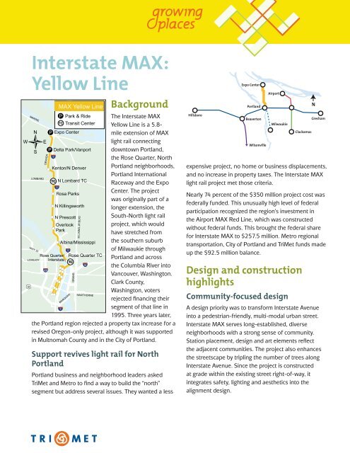
<strong>Interstate</strong> <strong>MAX</strong>:<br />
<strong>Yellow</strong> <strong>Line</strong><br />
<strong>MAX</strong> <strong>Yellow</strong> <strong>Line</strong><br />
Park & Ride<br />
Transit Center<br />
Expo Center<br />
Delta Park/Vanport<br />
Kenton/N Denver<br />
N Lombard TC<br />
Rosa Parks<br />
N Killingsworth<br />
N Prescott<br />
Overlook<br />
Park<br />
Albina/Mississippi<br />
Rose Quarter TC<br />
Background<br />
The <strong>Interstate</strong> <strong>MAX</strong><br />
<strong>Yellow</strong> <strong>Line</strong> is a 5.8-<br />
mile extension of <strong>MAX</strong><br />
light rail connecting<br />
downtown Portland,<br />
the Rose Quarter, North<br />
Portland neighborhoods,<br />
Portland International<br />
Raceway and the Expo<br />
Center. The project<br />
was originally part of a<br />
longer extension, the<br />
South-North light rail<br />
project, which would<br />
have stretched from<br />
the southern suburb<br />
of Milwaukie through<br />
Portland and across<br />
the Columbia River into<br />
Vancouver, Washington.<br />
Clark County,<br />
Washington, voters<br />
rejected financing their<br />
segment of that line in<br />
1995. Three years later,<br />
the Portland region rejected a property tax increase for a<br />
revised Oregon-only project, although it was supported<br />
in Multnomah County and in the City of Portland.<br />
Support revives light rail for North<br />
Portland<br />
Portland business and neighborhood leaders asked<br />
<strong>TriMet</strong> and Metro to find a way to build the “north”<br />
segment but address several issues. They wanted a less<br />
Hillsboro<br />
Expo Center<br />
Portland<br />
Beaverton<br />
Wilsonville<br />
Airport<br />
Milwaukie<br />
expensive project, no home or business displacements,<br />
and no increase in property taxes. The <strong>Interstate</strong> <strong>MAX</strong><br />
light rail project met those criteria.<br />
Nearly 74 percent of the $350 million project cost was<br />
federally funded. This unusually high level of federal<br />
participation recognized the region’s investment in<br />
the Airport <strong>MAX</strong> Red <strong>Line</strong>, which was constructed<br />
without federal funds. This brought the federal share<br />
for <strong>Interstate</strong> <strong>MAX</strong> to $257.5 million. Metro regional<br />
transportation, City of Portland and <strong>TriMet</strong> funds made<br />
up the $92.5 million balance.<br />
Design and construction<br />
highlights<br />
Community-focused design<br />
Clackamas<br />
Gresham<br />
A design priority was to transform <strong>Interstate</strong> Avenue<br />
into a pedestrian-friendly, multi-modal urban street.<br />
<strong>Interstate</strong> <strong>MAX</strong> serves long-established, diverse<br />
neighborhoods with a strong sense of community.<br />
Station placement, design and art elements reflect<br />
the adjacent communities. The project also enhances<br />
the streetscape by tripling the number of trees along<br />
<strong>Interstate</strong> Avenue. Since the project is constructed<br />
at grade within the existing street right-of-way, it<br />
integrates safety, lighting and aesthetics into the<br />
alignment design.<br />
N
Brian Borrello’s Silicon Forest, at the<br />
<strong>Interstate</strong>/Rose Quarter <strong>MAX</strong> Station,<br />
presents a metaphor for displacement<br />
and change.<br />
Rose Quarter junction<br />
In 2009, the <strong>MAX</strong> <strong>Yellow</strong> <strong>Line</strong> moved from the eastwest<br />
downtown alignment that it had shared with the<br />
Red and Blue lines since 2004 to the new north-south<br />
alignment also used by the Green <strong>Line</strong>. At the east end<br />
of the Steel Bridge, <strong>Interstate</strong> <strong>MAX</strong> separates from this<br />
shared alignment and enters the median of the <strong>Yellow</strong><br />
<strong>Line</strong>, which it follows for the next 4.5 miles, climbing<br />
a six percent grade between Albina and Overlook Park<br />
stations.<br />
Moving Paul Bunyan<br />
In the Kenton neighborhood, a 37-foot, six-ton statue<br />
of Paul Bunyan served as a community icon for more<br />
than 40 years—and stood in the middle of the planned<br />
alignment. A community event, was held to move the<br />
statue 59.2 feet to a new plaza. Across from the statue,<br />
bright blue, hoof-shaped seating sculptures invoke<br />
Paul’s legendary companion, Babe the Blue Ox.<br />
Community art celebrates cultural<br />
diversity<br />
Guided by an art advisory committee comprised of<br />
citizens and art professionals who live or work near the<br />
<strong>Interstate</strong> corridor, <strong>TriMet</strong>’s Public Art Program captured<br />
the diverse cultural and historic character of the 10<br />
station areas. It also provided direction for the 18 artists<br />
and writers who developed more than 50 art elements<br />
for the line, and inspiration for an oral history project<br />
entitled Intersections: <strong>TriMet</strong> <strong>Interstate</strong> <strong>MAX</strong> Light Rail<br />
Community History Project.<br />
Construction innovations<br />
A model in earth-friendly construction<br />
<strong>Interstate</strong> <strong>MAX</strong> used innovative, green construction<br />
practices previously not widely applied to light rail<br />
construction. The focus on green construction saved $3<br />
million in construction costs. Examples include:<br />
• Using 6,000 recycled plastic railroad ties in<br />
embedded trackway<br />
• Employing recycled plastic bollards and chains to<br />
discourage trespassing<br />
• Creating art elements for stormwater<br />
management<br />
• Recycling asphalt and concrete as base materials<br />
for roadways, trackway and sidewalks<br />
• Expanding wetlands and tripling the number of<br />
trees along the alignment<br />
• Reusing excavated soils in sewer trenches and<br />
planters, saving on hauling and disposal<br />
• Recycling excavated old trolley rails<br />
• Designing system support buildings to shed<br />
rainwater into the ground rather than into the<br />
storm sewer system<br />
Success with DBEs and workforce<br />
diversity<br />
From the beginning, <strong>TriMet</strong> wanted the community in<br />
North and Northeast Portland to benefit economically<br />
from the <strong>Interstate</strong> <strong>MAX</strong> project as much as possible. It<br />
also committed to using contractors and a workforce on<br />
the project that reflected the diversity of the community.<br />
In the process, <strong>TriMet</strong> created a national model for<br />
Disadvantaged Business Enterprise (DBE) involvement.<br />
Through innovative contracting—including breaking<br />
up large contracts into smaller ones and rotating<br />
DBE subcontractors within a scope of work—as well<br />
as technical and financial assistance to DBEs, <strong>TriMet</strong><br />
worked together with its prime contractors to achieve<br />
some remarkable results:
• 19 percent ($36 million) of the project’s total<br />
contracting dollars went to local DBEs<br />
• $8.1 million in contracts went to DBE<br />
subcontractors in North and Northeast Portland<br />
Business support program<br />
Many of the businesses along <strong>Interstate</strong> Avenue<br />
are small, owner-operated enterprises. To minimize<br />
construction impacts, <strong>TriMet</strong> maintained access to<br />
businesses along the avenue and worked in 3- to<br />
4-block segments to complete work as quickly as<br />
possible.<br />
To further offset possible construction impacts, partner<br />
agencies created an advertising campaign to draw<br />
in business. The broad-based campaign included<br />
advertisements, direct mail, promotions, financial<br />
assistance, technical workshops for the businesses and<br />
a “Lunch Bus” that brought 14,000 people to <strong>Interstate</strong><br />
restaurants. Over 50 new businesses had opened on<br />
<strong>Interstate</strong> Avenue by December 2004, eight months<br />
after the line opened.<br />
Ahead of schedule and under budget<br />
The <strong>Interstate</strong> <strong>MAX</strong> project opened four months early<br />
on May 1, 2004, and millions under budget. Much of the<br />
time and money savings came from these initiatives:<br />
• Value engineering<br />
• Utilizing the construction management/general<br />
contractor delivery method<br />
• Bringing the construction contractor into the<br />
design phase early<br />
• Using innovative construction practices and<br />
materials<br />
Technical highlights<br />
Safety<br />
Due to its location in an high pedestrian traffic<br />
environment, a post and chain barrier was installed<br />
between the tracks for the length of the project. This<br />
system, previously used on the Eastside <strong>MAX</strong> line,<br />
prevents passengers from walking out behind a train<br />
into the path of an oncoming one. The use of recycled<br />
plastic bollards (posts) and chain eliminated the need<br />
for an expensive grounding system, which had been<br />
required with the steel chains and bollards used on<br />
<strong>TriMet</strong>’s previous rail projects. Zee crossings were<br />
also used to protect pedestrians, and new countdown<br />
crossing signals were introduced—the first use of these<br />
in Portland.<br />
Vanport Bridge<br />
North of Kenton, <strong>MAX</strong> <strong>Yellow</strong> <strong>Line</strong> is carried on an<br />
elevated structure. The 4,000-foot-long Vanport Bridge<br />
carries light rail over several industrial properties, a<br />
railroad, slough, floodplain and highways. This long<br />
structure was named in memory of the city of Vanport.<br />
Formerly located at this site, the city was washed away<br />
by floodwaters in 1948, killing at least 15 people and<br />
leaving 18,000 residents homeless.<br />
Vehicles<br />
<strong>TriMet</strong> purchased 17 new low-floor rail cars sporting<br />
<strong>TriMet</strong>’s new logo and colors, along with 10 more for<br />
ridership growth.<br />
Transit-oriented development<br />
The <strong>Yellow</strong> <strong>Line</strong> was intended to stimulate reinvestment<br />
in the commercial corridor and residential areas<br />
surrounding the <strong>MAX</strong> stations. Notable additions on<br />
<strong>Interstate</strong> Avenue include New Seasons grocery store,<br />
Trillium School, Providence Medical Clinic, a renovated<br />
Fred Meyer and an expansion of Kaiser Permanente’s<br />
<strong>Interstate</strong> Medical Office, in addition to many new small<br />
businesses. The Overlook, a 30-unit condominium<br />
project located at N Shaver Street, completed in 2007,<br />
was the first new mixed-use project in a <strong>Yellow</strong> <strong>Line</strong><br />
station area. In 2009, the Patton Park Apartments<br />
opened, offering 53 affordable housing units. New<br />
housing and commercial options increase the ease of a<br />
transit-oriented lifestyle.
Snapshots<br />
Funding<br />
Annual Ridership<br />
6<br />
5<br />
$38.5 million<br />
<strong>TriMet</strong><br />
Total: $350 million<br />
$30 million<br />
City of Portland<br />
$257.5 million<br />
Federal<br />
in millions of rides, per year<br />
4<br />
3<br />
2<br />
1<br />
5.4 million<br />
rides in FY12<br />
$24 million<br />
Regional transportation funds<br />
Timeline<br />
1999 Preliminary design and environmental studies<br />
began<br />
2000-2001 Project approval and construction<br />
2002 Utility relocation completed<br />
Winter 2003 Track/street/sidewalk construction<br />
completed<br />
Summer 2003 Art pieces installed at all 10 stations<br />
2003-2004 Signals, overhead power, shelters, testing<br />
May 1, 2004 Opened four months ahead of schedule<br />
Facilities<br />
Length 5.8 miles<br />
Stations 10<br />
Surface Park & Rides 2 with 300 spaces each<br />
Maintenance facility Expansion of the Ruby Junction<br />
Maintenance Facility in Gresham to accommodate the<br />
new trains<br />
0<br />
FY04<br />
FY05<br />
Frequency<br />
Approximately every 15 minutes during peak hours;<br />
approximately every 35 minutes during early morning<br />
and nighttime service.<br />
Travel times<br />
FY06<br />
FY07<br />
Expo Center to downtown Portland 25 minutes<br />
Bus connections<br />
FY08<br />
Includes 12 connections with <strong>TriMet</strong> bus lines along the<br />
<strong>Interstate</strong> alignment and numerous bus lines downtown.<br />
FY09<br />
FY10<br />
FY11<br />
Available in other<br />
formats:<br />
trimet.org<br />
503-238-7433<br />
TTY 503-238-5811<br />
FY12<br />
<strong>Interstate</strong> <strong>MAX</strong> <strong>Yellow</strong> <strong>Line</strong> Tour <strong>Fact</strong> <strong>Sheet</strong> / August 2012