Localities of collecting trips in Ethiopia, GTI project 1 (October 2010 ...
Localities of collecting trips in Ethiopia, GTI project 1 (October 2010 ...
Localities of collecting trips in Ethiopia, GTI project 1 (October 2010 ...

You also want an ePaper? Increase the reach of your titles
YUMPU automatically turns print PDFs into web optimized ePapers that Google loves.
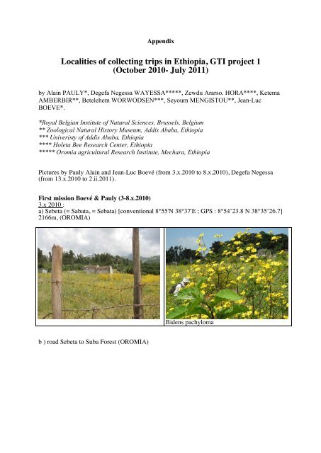
Appendix<br />
<strong>Localities</strong> <strong>of</strong> <strong>collect<strong>in</strong>g</strong> <strong>trips</strong> <strong>in</strong> <strong>Ethiopia</strong>, <strong>GTI</strong> <strong>project</strong> 1<br />
(<strong>October</strong> <strong>2010</strong>- July 2011)<br />
by Ala<strong>in</strong> PAULY*, Degefa Negessa WAYESSA*****, Zewdu Ararso. HORA****, Ketema<br />
AMBERBIR**, Betelehem WORWODSEN***, Seyoum MENGISTOU**, Jean-Luc<br />
BOEVE*.<br />
*Royal Belgian Institute <strong>of</strong> Natural Sciences, Brussels, Belgium<br />
** Zoological Natural History Museum, Addis Ababa, <strong>Ethiopia</strong><br />
*** Univeristy <strong>of</strong> Addis Ababa, <strong>Ethiopia</strong><br />
**** Holeta Bee Research Center, <strong>Ethiopia</strong><br />
***** Oromia agricultural Research Institute, Mechara, <strong>Ethiopia</strong><br />
Pictures by Pauly Ala<strong>in</strong> and Jean-Luc Boevé (from 3.x.<strong>2010</strong> to 8.x.<strong>2010</strong>), Degefa Negessa<br />
(from 13.x.<strong>2010</strong> to 2.ii.2011).<br />
First mission Boevé & Pauly (3-8.x.<strong>2010</strong>)<br />
3.x <strong>2010</strong> :<br />
a) Sebeta (= Sabata, = Sebata) [conventional 8°55'N 38°37'E ; GPS : 8°54’23.8 N 38°35’26.7]<br />
2166m, (OROMIA)<br />
Bidens pachyloma<br />
b ) road Sebeta to Suba Forest (OROMIA)
Cassia alata<br />
Cassia alata<br />
c) Suba Forest [conventional: 8°58'N 38°32'E] (OROMIA)<br />
Bidens sp.<br />
Fabaceae<br />
d) road Suba to Holeta (station Brassicaceae) (OROMIA)
J- L. Boeve and Degefa <strong>in</strong> Brassica crop Brassica spp.<br />
e) road Suba to Holeta (station blue Lamiaceae) (OROMIA)<br />
Plectranthus garckeanus (Lamiaceae)<br />
4.x.<strong>2010</strong>:<br />
Sebeta [conventional 8°55'N 38°37'E] (OROMIA)<br />
5.x.<strong>2010</strong>:<br />
Holeta (=Genet) [conventional: 9°04'N 38°30'E] (OROMIA)
J.-L. Boeve and tra<strong>in</strong>ees<br />
A. Pauly and tra<strong>in</strong>ees <strong>collect<strong>in</strong>g</strong> on Bidens<br />
pachyloma<br />
6.x.<strong>2010</strong><br />
a) Akaki [conventional: 8°52'N 38°47'E] (OROMIA)<br />
Crops (Brassica sp.)<br />
Ech<strong>in</strong>ops hispidus (Asteraceae)<br />
b) Mojo [conventional: 8°36'N 39°07'E] (OROMIA)<br />
Maize with Guizotia scabra<br />
Fallow land with Helianthus annuus<br />
(sunflower)
Guizotia scabra (Asteraceae)<br />
Sunflowers<br />
c) Koka [conventional: 8°26'N 39°02'E; GPS: 8°22’25.2N 39°00’07.1E], 1609m (OROMIA)<br />
Heliotropium c<strong>in</strong>erascens (Borag<strong>in</strong>aceae)<br />
Anethum graveolens (Apiaceae)<br />
7.x.<strong>2010</strong><br />
a) Sululta [conventional: 9°11'N 38°45'E] (OROMIA)<br />
Echium plantag<strong>in</strong>eum (Borag<strong>in</strong>aceae)<br />
Echium plantag<strong>in</strong>eum
) Chancho [conventional: 9°20'N 38°44'E] (OROMIA)<br />
Otostegia <strong>in</strong>tegrifolia (Lamiaceae)<br />
Otostegia <strong>in</strong>tegrifolia (Lamiaceae)<br />
Trifolium sp.<br />
Asteraceae<br />
c) Muketuri [conventional: 9°33'N 38°52'E] (OROMIA)
Achyranthes aspera (Amaranthaceae)<br />
d) Debre Libanos [conventional: 9°43'N 38°52'E ; GPS : 9°43’36.6N 38°48’20E] , 2573m<br />
(OROMIA)<br />
Plectranthus punctatus (Lamiaceae)<br />
8.x.<strong>2010</strong><br />
Baakelo 14km N. Debre Birhan [conventional 9°41'N 39°32'E; GPS: 9°42’25.4N<br />
39°38’11.4E], 2880m (AMHARA)
Salvia schimperi (Lamiaceae)<br />
Carduus camaecephalus (Asteraceae)<br />
Lippia adoensis (Verbenaceae)
Plectranthus ornatus (Lamiaceae)<br />
Plectranthus ornatus (Lamiaceae)<br />
12.x.<strong>2010</strong>, between Kolobo [conventional 9°04'N 38°44'E] and Genet (OROMIA).<br />
13.x.<strong>2010</strong>, Sabata [conventional 8°55'N 38°37'E] (OROMIA)<br />
14.x.<strong>2010</strong>, Mt Entoto [conventional 9°06'N 38°42'E; GPS: 9°05’09,5N 38°45‘36E] (2850m)<br />
(ADDIS ABEBA)<br />
10-16.x.<strong>2010</strong>, Holeta (leg. Zewdu) (OROMIA)
17.x.<strong>2010</strong>, Muger [conventional 9°38'N 38°37'E], 60 km N. Holeta (leg. Zewdu) (OROMIA)<br />
First trip to Bale Mounta<strong>in</strong>s: [OROMIA Region, BALE zone]<br />
(collectors: Degefa Negessa, Zewdu Ararso, Ketema Amberbir and Betelehem<br />
Wondwosen)<br />
20.x.<strong>2010</strong>,<br />
Sanate Park (= Sanetti Plateau ?) [conventional 6°40'N 39°40'E] and Mt Batu (BALE)<br />
21.x.<strong>2010</strong>, Goba [conventional 7°01'N 39°59'E] (BALE)<br />
21.x.<strong>2010</strong>,<br />
20 km E. Robe [conventional 7°08'N40°00'E] (BALE)
22.x.<strong>2010</strong>, Ali [conventional 7°15'N 39°56'E] (BALE)<br />
22.x.<strong>2010</strong>, Between Ali and Gasera or Gasera [conventional 7°22'N 40°13'E] (BALE)<br />
23.x.<strong>2010</strong>, Goro [conventional 6°59'N 40°30'E] (BALE)<br />
24.x.<strong>2010</strong>, Sebsibe Cave (= Sebsibe Washa) [conventional 7°03'39°35'E], between D<strong>in</strong>sho<br />
and Adaba (BALE)
Senecio fresenii<br />
Bidens macroptera<br />
24.x.<strong>2010</strong>, Cheleleka forest [7°01'N 39°30'E], between D<strong>in</strong>sho and Adaba (BALE)
Plectranthus garckeanus<br />
25.x.<strong>2010</strong>, Dark<strong>in</strong>a Meskeli Forest (7°01'N 39° 28'E) (between Adaba and D<strong>in</strong>sho) (BALE)<br />
25.x.<strong>2010</strong>, Dodola (6°59'N 39°11'E) (BALE)<br />
25.X.<strong>2010</strong>, K<strong>of</strong>ale (7°04’N 38°47’E), 2200m, between Sashemene and Dodola (BALE)<br />
Transect Mechara (OROMIA Region, WEST HARARGHE zone) (rec. Degefa)<br />
30-31.x., 3, 10, 13.xi.<strong>2010</strong>, Mechara (leg. Degefa) [conventional: 8°36'N 40°19'E], 1800 m<br />
6,7,9.xi.<strong>2010</strong>, Sororo, between Gelemso and Asbe Teferi (leg. Degefa) [? +- 8°54'N 40°47'E]<br />
Transect Gedo (rec Zewdu):<br />
29-30.x.<strong>2010</strong>, F<strong>in</strong>chaa Dam between Gedo and Shambu, 2100m, 9°33‘N 37°23‘E (leg.<br />
Zewdu) (OROMIA)<br />
4.xi.<strong>2010</strong>, Holeta (leg. Zewdu) (OROMIA)<br />
6-7.xi.<strong>2010</strong>, Guder (between Ambo and Gedo) (leg. Zewdu), 8°58’N 37°44’E, 1700m,<br />
(OROMIA)
14.xi.<strong>2010</strong>, Bako (between Tibe and Sire) (leg. Zewdu) Google map: 9°07'35"N 37°03'14"E<br />
(OROMIA)<br />
Trip to Dese (= Dessie) [AMHARA]<br />
(collectors: Degefa Negessa, Zewdu Ararso, Ketema Amberbir and Betelehem<br />
Wondwosen)<br />
17.xi.<strong>2010</strong>, Pasomila (Paso Mile) (between Hayk and Wochale) [Wuchale: conventional<br />
11°30'N 39°36'E]<br />
17-18.xi.<strong>2010</strong>, Hayk [conventional 11°18'N 39°41'E]<br />
18.xi.<strong>2010</strong>, Lake Hayk [conventional: 11°20'N 39°43'E] (2030m)
19.xi.<strong>2010</strong>, Haragoma (Mt Haregoma) (between Dese and Kombolecha) [11°06'N 39°41'E]<br />
20-21.xi.<strong>2010</strong>, Chefawoledi (Chefa Woledi) [conventional: 11°00'N 39°46'E]<br />
Hygrophila auriculata (Acanthaceae)
21.xi.<strong>2010</strong>, Kemise [conventional: 10°43'N 39°52'E]<br />
22.xi.<strong>2010</strong>, Karakore [conventional: 10°25'N 39°56'E]<br />
22.xi.<strong>2010</strong>, Efrata (mid way between Robit and Senbete) [10°09'N 39°59'E]<br />
Aloe berhana (Aloeaceae)<br />
Transect Holeta to Gedo (rec. Zewdu):<br />
25 -26.xii.<strong>2010</strong>, 1 & 4.i.2011, Holeta (OROMIA)<br />
12.i.2011, Bako [Google map: 9°07'35"N 37°03'14"E], between Tibe and Sire (OROMIA)
Transect to Mechara (rec Degefa) [OROMIA Region, WEST HARARGHE Zone]:<br />
4,5,6,16,18,19,25.xii.<strong>2010</strong>; 16, 17, 21.i.2011, Mechara (Machara), 1800 m<br />
29.xii.<strong>2010</strong>, Michata [Google map: 8°34'27"N 40°19'21"E]<br />
1.i.2011, Milkay, 50 km S. <strong>of</strong> Mechara, 8°08’N 40°29’E<br />
Asteraceae n°111 Asteraceae n°111<br />
2.i.2011, Tutis, 40 km SW <strong>of</strong> Machara (8°15’N 40°07’E ?).
Asteraceae n°111<br />
Asteraceae n°111<br />
5.i.2011, Gadullo [GPS 8°23'30"N 40°23'37"E], 1625m<br />
6.i.2011, Sororo
Vernonia<br />
Flower<strong>in</strong>g shrub n°112<br />
Second trip to Bale (OROMIA Region, BALE Zone)<br />
(collectors: Degefa Negessa, Zewdu Ararso, Ketema Amberbir and Betelehem<br />
Wondwosen):<br />
24.i.2011, Ssashemene [Google map: 7°11'56""N 38°37'30"E] , between Ziway and Awassa<br />
26.i.2011, Mt Bale (Sanete) [Google map: 6°46'29"N 39°43'35"E], between Goba and Dola-<br />
Mena
Senecio myriocephalum Sch.-Bip. Ex A. Rich<br />
(Asteraceae)
? Inula confertiflora (Asteraceae)<br />
Salvia nilotica Juss.ex Jacq. (Lamiaceae)<br />
27.i.2011, Harenna Forest [Google map: 6°34'48"N 39°43'30"E], between Goba and Dola<br />
Mena (Dello)<br />
29.i.2011, Dola Mena (Dallo, Dello Manna) [Google map: 6°24'58"N 39°50'30"E], between<br />
Goba and Legele Borena<br />
30.i.2011,<br />
a) Harenna Forest [Google map: 6°34'48"N 39°43'30"E], between Goba and Dello<br />
b) Dola Mena (Dallo) [Google map: 6°24'58"N 39°50'30"E], between Goba and Legele<br />
Borena
Vernonia auriculifera Hiern. (Asteraceae)<br />
friche avec Hypoestes forsakolii (Vahl) R. Sch.<br />
(Acanthaceae)<br />
? Helichrysum (Asteraceae)
Vernonia auriculifera (Asteraceae)<br />
31.i.2011, S<strong>of</strong>'Omar (S<strong>of</strong>umer) [Google map: 6°13'06"N 39°46'18"E]
Aloe berhana et Aloe sp.<br />
Aloe berhana et Aloe sp.<br />
1.ii.2011, Bekele Forest [Google map approximatively 7°01'N 39°34'E], midway between<br />
Adaba and D<strong>in</strong>sho.
Ech<strong>in</strong>ops macrochaetus A. Rich. (Asteraceae)<br />
Ech<strong>in</strong>ops macrochaetus A. Rich. (Asteraceae)<br />
Senecio lyratus Forssk. (Asteraceae)<br />
Senecio lyratus Forssk. (Asteraceae)<br />
1.ii.2011, D<strong>in</strong>sho National Park (Google map: 7°06'N 39°45'E)
Hypericum revolutum Vahl. (Hypericaceae)<br />
Hypericum revolutum Vahl. (Hypericaceae)<br />
Aaa<br />
Jimma Trip (16-20 June 2011) (collectors: Degefa Negessa and Ketema Amberbir )<br />
(OROMIA)<br />
16-17.vi.2011, Didessa river, north <strong>of</strong> Jimma, after Agaro, near Dembi (Google map: 8°02'N<br />
36°28'E) (OROMIA).
19.vi.2011, Sokoru (conventional: 7°55'N 37°25'E) (OROMIA).<br />
20.vi.2011, Gibe (conventional: 7°45'N 37°39'E) (OROMIA).<br />
Awash and Awasa trip (20-23.vii.2011) (collectors: Zewdu Ararso, Ketema Amberbir<br />
and Betelehem Wondwosen]:<br />
20-21.vii.2011: Awash National park, between Metahara and Awash Town [Google map:<br />
8°55'N 40°02'E] (AFAR)<br />
23.vii.2011: Tikur Wuha (Wondo Genet), between Awasa and Shashemene [Google map:<br />
7°01'N 38°34'E] (OROMIA)
The Zoological Museum <strong>in</strong> Addis Ababa<br />
a. - Entrance <strong>of</strong> the Museum b. - Insect room (With Dr Seyoum and Katama)<br />
c. - Mammal room d. - Bird room<br />
e. - Nile crocodile <strong>in</strong> bird room f. - Bird galery<br />
Fig. 1. The Zoological Museum <strong>in</strong> Addis Ababa
Aaa<br />
a. - Butterfly cab<strong>in</strong>ets b. - Amphibian room<br />
c. - Mammals d. - Hymenoptera cab<strong>in</strong>et.<br />
e. - Reserve to be managed f. - Bee collections<br />
Fig. 2. The Zoological Museum <strong>in</strong> Addis Ababa
Aaa<br />
a. - Holeta Bee Research Centre b. Entrance<br />
c. - Mission <strong>of</strong> the Centre d. - Gardens<br />
e. - f. - Tra<strong>in</strong>ees <strong>in</strong> Holeta<br />
Fig. 3. Holeta Bee Research Station
Aaa<br />
a. - Traditional fores beekeep<strong>in</strong>g b. - Back yard beekeep<strong>in</strong>g<br />
c. - Modern hives d. - Tree log hives (Gaagura Adaa)<br />
e. - Different tools for honey hunt<strong>in</strong>g, from<br />
Meznenger people, Gembella.<br />
f. - Tree log hive (Gaagura Adaa)<br />
Fig.4. - The Museum <strong>in</strong> the Holeta Bee Research Centre.
a. - Different tools for honey hunt<strong>in</strong>g, from<br />
Meznenger people, Gembella.<br />
b. - Beekeeper's smooker.<br />
c. - Smooker.<br />
d. - Log hive from Bale area.<br />
e. - Honey conta<strong>in</strong>ers (made from wood, animal f. - Teji conta<strong>in</strong>ers<br />
sk<strong>in</strong> and clay pot).<br />
Fig. 5. The Museum <strong>in</strong> the Holeta Bee Research Centre.
Aaa<br />
a.- Traditional teji dr<strong>in</strong>k<strong>in</strong>g ustensils<br />
b. - Deep log barrel for teji.<br />
c. - Chereka top bar. d. - Kenya top bar.<br />
e<br />
f<br />
Fig. 6. The Museum <strong>in</strong> the Holeta Bee Research Centre.
Aaa<br />
a<br />
b<br />
c<br />
e<br />
d<br />
f<br />
Fig. 7. - The Museum <strong>in</strong> the Holeta Bee Research Centre.
Authors