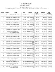
Parcel - Wyoming State Lands
Parcel - Wyoming State Lands
Parcel - Wyoming State Lands

You also want an ePaper? Increase the reach of your titles
YUMPU automatically turns print PDFs into web optimized ePapers that Google loves.
Wednesday, November 06, 2013<br />
Auction List<br />
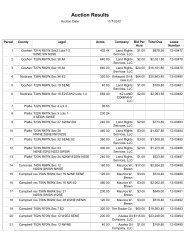
(*) = Tracts to be Auctioned at 12.5% Royalty Rate (N) = Nominated <strong>Lands</strong> (W) = Withdrawn <strong>Lands</strong> Stipulation Codes (see definitions at the end of this document)<br />
<strong>Parcel</strong> # County Legal Description Acres Fund Stipulations<br />
1 Goshen T20N R60W 640.00 CS 136<br />
Sec 16 All<br />
2 W Goshen T22N R60W 640.00 CS 136<br />
Sec 16 All<br />
3 Goshen T23N R61W 80.00 FL 136<br />
Sec 17 N2NE<br />
4 Goshen T27N R61W 640.00 CS 136<br />
Sec 16 All<br />
5 Laramie T14N R62W 480.00 FL 136<br />
Sec 14 N2:SE<br />
6 Laramie T14N R62W 640.00 CS 136<br />
Sec 16 All<br />
7 Laramie T14N R62W 640.00 CS 117,136<br />
Sec 36 All<br />
8 Laramie T18N R62W 160.00 CS 136<br />
Sec 13 S2NW:N2SW<br />
9 Laramie T18N R62W 240.00 CS 117,136<br />
Sec 14 S2NE:E2NW<br />
Sec 15 S2NW<br />
10 Goshen T26N R62W 560.00 FL 136<br />
Sec 34 N2NE:SWNE:W2:N2SE:SWSE<br />
11 Goshen res T28N R62W 640.00 CS 136<br />
Trt 101 (formerly Sec 36 All)<br />
12 Niobrara T33N R62W 239.77 SR 136<br />
Sec 4 Lot 3:SENW:N2SW:W2SE<br />
1
13 Niobrara T33N R62W 240.54 SR 136<br />
Sec 5 Lot 2:S2NE<br />
Sec 9 NWNE:S2NE<br />
14 Niobrara T33N R62W 640.00 CS 136<br />
Sec 16 All<br />
15 Niobrara T33N R62W 640.00 CS 136<br />
Sec 36 All<br />
16 Goshen T24N R63W 320.00 FL 136<br />
Sec 10 S2<br />
17 Goshen T24N R63W 640.00 CS 136<br />
Sec 16 All<br />
18 Goshen T25N R63W 640.00 CS 117,136<br />
Sec 36 All<br />
19 W Laramie T12N R64W 640.00 CS 117,136<br />
Sec 16 All<br />
20 Laramie T12N R64W 597.96 CS 117,136<br />
Sec 16 N2:N2S2:Lots 5-8<br />
21 Crook T49N R64W 320.00 CS 136<br />
Sec 16 W2<br />
22 Laramie T14N R65W 400.00 PB 136<br />
Sec 34 N2:N2SW<br />
23 Laramie T17N R65W 640.00 CS 136<br />
Sec 26 All<br />
24 Laramie T17N R65W 640.00 CS 136<br />
Sec 28 All<br />
25 Niobrara T33N R65W 440.35 IA 117,136<br />
Sec 5 Lots 2-<br />
4:S2N2:NWSW:S2SW:SWSE<br />
2
26 Niobrara T33N R65W 330.86 PB 136<br />
Sec 6 Lots 3-7:SENW:E2SW<br />
27 Niobrara T33N R65W 641.88 PB 136<br />
Sec 7 E2:E2W2:Lots 1-4<br />
28 Crook T49N R65W 640.00 CS 117,136<br />
Sec 16 All<br />
29 Laramie T12N R66W 334.18 PB 136<br />
Sec 6 Lots 3-7:SENW:E2SW<br />
30 Laramie T14N R66W 175.51 PB 136<br />
Sec 16 Pt S2S2S2NE:SE<br />
31 Laramie T14N R66W 319.65 CS 136<br />
Sec 36 Pt, N2NE:S2NE:Pt,<br />
S2NW:NESW:Pt, NWSW:N2SE<br />
32 Laramie T18N R66W 40.00 CS 117,136<br />
Sec 17 SWNW<br />
33 Niobrara T32N R66W 160.00 CS 136,143<br />
Sec 35 SE<br />
34 Niobrara T32N R66W 640.00 CS 136,143<br />
Sec 36 All<br />
35 Niobrara T40N R66W 640.00 CS 136,140<br />
Sec 16 All<br />
36 Niobrara T41N R66W 640.00 CS 136,140<br />
Sec 36 All<br />
37 Crook T49N R66W 640.00 CS 136,143<br />
Sec 36 All<br />
38 Laramie T12N R67W 196.22 PB 117,136<br />
Sec 4 Pt,Lots 1-2:S2NE<br />
3
39 Laramie T13N R67W 106.26 CS 136<br />
Sec 26 Pt N2NW:SWNW<br />
40 Laramie T13N R67W 292.33 UN 136<br />
Sec 28 E2<br />
41 Laramie T13N R67W 424.95 PB 136<br />
Sec 32 N2:SE<br />
42 Laramie T13N R67W 145.62 CS 136<br />
Pt Sec 34 NW<br />
43 Converse T32N R67W 151.37 CS 136<br />
Sec 7 NESW:Lots 3-4:NWSE<br />
44 Converse T32N R67W 190.73 SR 136<br />
Sec 18 S2NE:Lots 1-2:SESE<br />
45 Niobrara T32N R67W 640.00 CS 136<br />
Sec 36 All<br />
46 Crook T52N R67W 435.31 FL 136<br />
Sec 18 NE:E2W2:Lot 4:W2SE<br />
47 * Laramie T13N R68W 640.00 CS 5,136<br />
Sec 16 All<br />
48 * Laramie T13N R68W 640.00 SR 117,136<br />
Sec 20 All<br />
49 Laramie T14N R68W 360.00 CS 5,117,136<br />
Sec 24 W2NW:NWSW:S2SW:SE<br />
50 Laramie T14N R68W 640.00 CS 5,136<br />
Sec 36 All<br />
51 Converse T31N R68W 640.00 CS 136<br />
Sec 16 All<br />
4
52 Weston T47N R68W 640.00 CS 136,140<br />
Sec 16 All<br />
53 Campbell T45N R69W 161.27 CS 136<br />
Sec 2 Lots 1-2:S2NE<br />
54 Campbell T46N R69W 640.00 CS 117,136,140<br />
Sec 16 All<br />
55 Campbell T48N R69W 40.00 CS 136,140<br />
Sec 20 SENW<br />
56 Campbell T48N R69W 40.00 CS 136<br />
Sec 27 SWSW<br />
57 W Campbell T48N R69W 320.00 CS 117,136,140<br />
Sec 32 E2<br />
58 Campbell T53N R69W 640.00 CS 136<br />
Sec 16 All<br />
59 Campbell T53N R69W 40.00 CS 117,136<br />
Sec 21 SESE<br />
60 Campbell T54N R69W 80.00 CS 117,136,140<br />
Sec 27 NENW:SWNW<br />
61 Campbell T54N R69W 40.00 CS 136,140<br />
Sec 29 NESW<br />
62 Platte T23N R70W 40.00 CS 136<br />
Sec 1 NESE<br />
63 Platte T23N R70W 160.00 CS 5,136<br />
Sec 23 E2SW:S2SE<br />
64 Converse T32N R70W 640.00 CS 136,140<br />
Sec 36 All<br />
5
65 Campbell T49N R70W 40.00 CS 136,140<br />
Sec 13 SENW<br />
66 Campbell T49N R70W 640.00 CS 136,143<br />
Sec 16 All<br />
67 Campbell T49N R70W 640.00 CS 136,140<br />
Sec 36 All<br />
68 Campbell T53N R70W 159.56 MH 117,136,140<br />
Sec 4 Lot 4:Sec 5 Lots 1,2:SENE<br />
69 Campbell T53N R70W 640.00 CS 117,136,143<br />
Sec 36 All<br />
70 Campbell T54N R70W 40.00 MH 117,136,140<br />
Sec 25 SESE<br />
71 Campbell T54N R70W 120.00 SR 117,136,140<br />
Sec 29 SWNW:W2SW<br />
72 Campbell res T57N R70W 640.00 CS 136<br />
Trt 44 (formerly Sec 16 All)<br />
73 W Campbell T43N R71W 640.00 CS 117,136,143<br />
Sec 36 All<br />
74 Campbell T49N R71W 79.04 CS 117,136,143<br />
Sec 6 Lots 3,4<br />
75 * Converse T32N R72W 160.00 FL 5,117,136<br />
Sec 33 N2NE<br />
Sec 34 N2NW<br />
76 * Converse T32N R72W 160.00 CS 5,117,136<br />
Sec 35 NE<br />
77 * Converse T32N R72W 640.00 CS 5,117,136<br />
Sec 36 All<br />
6
78 W Campbell res T48N R72W 600.00 CS 117,136,143<br />
Sec 16 N2:N2SW:SESW:SE<br />
79 W Campbell T49N R72W 640.00 CS 136<br />
Sec 16 All<br />
80 Campbell T49N R72W 120.00 FL 123,136<br />
Sec 26 SWNE:W2SE<br />
81 Campbell T49N R72W 200.00 FL 123,136<br />
Sec 35 NWNE:S2NE:N2SE<br />
82 Campbell T49N R72W 160.00 CS 123,136<br />
Sec 36 SW<br />
83 Campbell T50N R72W 80.00 CS 136,143<br />
Sec 13 SWSW<br />
Sec 14 SESE<br />
84 Campbell T50N R72W 200.00 CS 117,136<br />
Sec 22 NWNE:NENW<br />
Sec 23 NENE:N2SW<br />
85 Campbell T50N R72W 200.00 CS 117,136<br />
Sec 24 NWNW:S2NW:E2SW<br />
86 Campbell T51N R72W 40.00 SR 117,136,143<br />
Sec 21 NWSW<br />
87 Campbell T51N R72W 40.00 CS 117,136,143<br />
Sec 21 SESE<br />
88 Campbell res T57N R72W 640.00 CS 117,136,143<br />
Trt 42 (formerly Sec 16 All)<br />
89 * Converse T32N R73W 160.00 CS 5,117,136<br />
Sec 32 S2NW:NENE:SWNE<br />
90 * Campbell T51N R73W 40.00 CS 117,136,143<br />
Sec 11 SWSW<br />
7
91 * Converse T32N R74W 80.00 CS 5,136<br />
Sec 27 E2SE<br />
92 * Campbell T51N R74W 40.00 MH 136,143<br />
Sec 26 SWNE<br />
93 * Converse T33N R75W 320.00 PE 5,117,136,143<br />
Sec 33 S2<br />
94 * Campbell T57N R75W 120.00 CS 117,136<br />
Sec 15 W2SW:SESW<br />
95 * Converse T33N R76W 160.00 PE 136,140<br />
Sec 20 SE<br />
96 * Converse T33N R76W 120.00 PE 136,140<br />
Sec 22 N2NW:SWNW<br />
97 * Converse T33N R76W 640.00 PE 136,140<br />
Sec 29 All<br />
98 * Converse T33N R76W 640.00 CS 5,117,136<br />
Sec 36 All<br />
99 * Converse T34N R76W 160.00 ES 136<br />
Sec 22 S2NE:N2NW<br />
100 * Campbell T52N R76W 80.00 HB 5,136<br />
Sec 35 NWNW:SENW<br />
101 Converse T41N R77W 640.00 CS 117,136<br />
Sec 36 All<br />
102 Natrona T37N R78W 520.00 CS 5,136,140<br />
Sec 36 SWNE:NW:S2<br />
103 * Natrona T41N R78W 640.00 CS 136<br />
Sec 36 All<br />
8
104 Johnson T42N R78W 40.00 CS 117,136<br />
Sec 24 SWSE<br />
105 Johnson T42N R78W 80.00 CS 136<br />
Sec 33 SENE:NESE<br />
106 Johnson T42N R78W 80.00 CS 136<br />
Sec 34 W2NW<br />
107 W Johnson T44N R78W 646.71 CS 117,136,140<br />
Sec 16 E2:SESW:Lots 1-8<br />
108 W Carbon T20N R79W 640.00 SS 5,136,140<br />
Sec 20 All<br />
109 * Natrona T33N R79W 320.00 CS 117,136<br />
Sec 27 E2<br />
110 Natrona T34N R79W 640.00 CS 136<br />
Sec 16 All<br />
111 Natrona T34N R79W 640.00 CS 94,117,136<br />
Sec 36 All<br />
112 Natrona T36N R79W 640.00 CS 136<br />
Sec 16 All<br />
113 Natrona T37N R79W 160.00 CS 136<br />
Sec 36 NW<br />
114 Natrona T39N R79W 80.16 CS 136<br />
Sec 4 Lot 4:SWNW<br />
115 Natrona T39N R79W 640.00 CS 136<br />
Sec 36 All<br />
116 W Natrona T40N R79W 640.00 CS 123,136<br />
Sec 16 All<br />
9
117 Carbon T26N R80W 640.00 CS 5,117,136<br />
Sec 16 All<br />
118 W Natrona T35N R80W 30.15 CS 5,117,136<br />
Sec 7 Lot 2<br />
119 Natrona T38N R80W 80.00 CS 136<br />
Sec 24 W2SE<br />
120 Natrona T38N R80W 80.00 CS 136,143<br />
Sec 25 W2NE<br />
121 Natrona T38N R80W 80.00 CS 136,140<br />
Sec 28 N2SW<br />
122 Natrona T39N R80W 640.00 CS 136<br />
Sec 36 All<br />
123 Natrona T40N R80W 640.00 CS 117,136,140<br />
Sec 16 All<br />
124 * Carbon T20N R81W 80.00 CS 136<br />
Sec 24 N2SW<br />
125 Natrona T31N R81W 148.31 CS 136,140<br />
Sec 6 E2SW:Lots 6-7<br />
126 Natrona T31N R81W 188.14 CS 117,136,140<br />
Sec 7 NENW:SESW:NESE:Lots 1,4<br />
127 Natrona T32N R81W 640.00 CS 136<br />
Sec 16 All<br />
128 Natrona T32N R81W 35.31 CS 117,136,143<br />
Sec 30 Lot 2<br />
129 Natrona T35N R81W 640.00 CS 136<br />
Sec 16 All<br />
10
130 Natrona T36N R81W 640.00 CS 136,140<br />
Sec 16 All<br />
131 Natrona T36N R81W 640.00 CS 5,136<br />
Sec 36 All<br />
132 Natrona T31N R82W 320.00 CS 136,140<br />
Sec 12 S2<br />
133 Natrona T35N R82W 280.00 CS 117,136,140<br />
Sec 8 SWNE:S2NW:NESW:NWSE:S2SE<br />
134 Natrona T35N R82W 640.00 CS 136<br />
Sec 36 All<br />
135 Natrona T35N R83W 640.00 CS 5,136<br />
Sec 16 All<br />
136 Natrona T35N R83W 240.00 CS 5,136<br />
Sec 21 N2NE:SWNE:E2SW:NWSE<br />
137 Natrona T35N R83W 80.00 CS 5,136<br />
Sec 28 N2NW<br />
138 Natrona T35N R83W 640.00 CS 5,136<br />
Sec 36 All<br />
139 Carbon T21N R87W 320.00 FL 5,117,136<br />
Sec 26 W2<br />
140 * Washakie T48N R88W 80.00 IA 136,143<br />
Sec 35 SWSE:SESW<br />
141 Carbon T19N R91W 640.00 CS 117,136,140<br />
Sec 36 All<br />
142 Carbon T17N R92W 320.00 CS 5,136,143<br />
Sec 16 W2<br />
11
143 * Fremont T39N R92W 40.00 CS 5,136<br />
Sec 3 SENW<br />
144 * Fremont T39N R92W 40.00 CS 5,117,136<br />
Sec 6 SESW<br />
145 Sweetwater T21N R93W 640.00 CS 136,143<br />
Sec 16 All<br />
146 Sweetwater T22N R93W 40.00 CS 136,143<br />
Sec 32 NENE<br />
147 Sweetwater T22N R93W 640.00 CS 136,143<br />
Sec 36 All<br />
148 * Big Horn T51N R93W 640.00 CS 136<br />
Sec 36 All<br />
149 * Big Horn T52N R93W 640.00 CS 136<br />
Sec 36 All<br />
150 Sweetwater T16N R94W 640.00 CS 136,143<br />
Sec 16 All<br />
151 Sweetwater T23N R94W 640.00 CS 136<br />
Sec 16 All<br />
152 * Fremont T33N R94W 160.00 CS 5,117,136,140<br />
Sec 12 NW<br />
153 Sweetwater T13N R95W 40.00 MH 136<br />
Sec 18 NENW<br />
154 Sweetwater T16N R95W 640.00 CS 136,143<br />
Sec 36 All<br />
155 Sweetwater T17N R95W 640.00 CS 136<br />
Sec 36 All<br />
12
156 Sweetwater T19N R95W 320.00 CS 136<br />
Sec 16 W2<br />
157 Sweetwater T20N R95W 40.00 CS 5,136<br />
Sec 32 NESW<br />
158 Sweetwater T21N R95W 640.00 CS 136,143<br />
Sec 16 All<br />
159 Sweetwater T23N R95W 640.00 CS 136<br />
Sec 16 All<br />
160 Sweetwater T25N R95W 640.00 CS 117,136,140<br />
Sec 36 All<br />
161 * Fremont T33N R95W 640.00 CS 5,117,136<br />
Sec 36 All<br />
162 Sweetwater T12N R96W 640.00 CS 5,136<br />
Sec 16 All<br />
163 Sweetwater T13N R96W 40.00 CS 136<br />
Sec 19 SENE<br />
164 Sweetwater T13N R96W 40.00 CS 5,136<br />
Sec 20 SESW<br />
165 Sweetwater T18N R96W 640.00 CS 136,143<br />
Sec 16 All<br />
166 Sweetwater T18N R96W 79.62 SB 136,143<br />
Sec 18 Lots 1,2<br />
167 Sweetwater T18N R96W 640.00 CS 117,136,143<br />
Sec 36 All<br />
168 Sweetwater T20N R96W 640.00 CS 136<br />
Sec 36 All<br />
13
169 Sweetwater T22N R96W 640.00 CS 136,143<br />
Sec 16 All<br />
170 Sweetwater T22N R96W 640.00 CS 136,143<br />
Sec 36 All<br />
171 * Fremont T32N R96W 640.00 CS 5,117,136,140<br />
Sec 16 All<br />
172 * Fremont T32N R96W 640.00 CS 136,140<br />
Sec 36 All<br />
173 Sweetwater T12N R97W 640.00 CS 5,136,143<br />
Sec 16 All<br />
174 Sweetwater T13N R97W 640.00 CS 136<br />
Sec 16 All<br />
175 Sweetwater T13N R97W 640.00 CS 5,136<br />
Sec 36 All<br />
176 W Sweetwater T16N R97W 640.00 CS 136<br />
Sec 36 All<br />
177 Sweetwater T18N R97W 640.00 CS 136<br />
Sec 16 All<br />
178 Sweetwater T19N R97W 160.00 CS 136<br />
Sec 16 N2N2<br />
179 Sweetwater T19N R97W 512.63 CS 136<br />
Sec 36 Lots 1-4:W2<br />
180 Sweetwater T20N R97W 512.23 CS 5,136,143<br />
Sec 36 Pt E2E2:W2E2:W2<br />
181 * Fremont T33N R97W 640.00 CS 117,136,140<br />
Sec 36 All<br />
14
182 Big Horn res T51N R97W 640.09 CS 136<br />
Trt 79 (formerly All Sec 36)<br />
183 Big Horn res T52N R97W 85.24 CS 136<br />
Trt 68 Lots 12,13,30 (formerly Pt Sec 36)<br />
184 Big Horn res T53N R97W 639.20 CS 136,143<br />
Trt 37 (formerly Sec 36 All)<br />
185 Sweetwater T12N R98W 81.10 CS 5,117,136<br />
Sec 3 Lots 3-4<br />
186 Sweetwater T12N R98W 160.00 CS 5,117,136<br />
Sec 4 S2NE:W2SE<br />
187 Sweetwater T12N R98W 160.00 CS 5,117,136<br />
Sec 9 E2NW:W2SW<br />
188 Sweetwater T17N R98W 640.00 CS 117,136<br />
Sec 16 All<br />
189 Sweetwater T17N R98W 640.00 CS 136,140<br />
Sec 36 All<br />
190 Sweetwater T18N R98W 640.00 CS 136<br />
Sec 36 All<br />
191 Sweetwater T25N R98W 640.00 CS 117,136,143<br />
Sec 16 All<br />
192 Sweetwater T25N R98W 640.00 CS 136,143<br />
Sec 36 All<br />
193 Sweetwater T16N R99W 640.00 CS 136,140<br />
Sec 36 All<br />
194 Sweetwater T17N R99W 640.00 CS 5,117,136,140<br />
Sec 16 All<br />
15
195 Sweetwater T17N R99W 560.00 CS 117,136,140<br />
Sec 36 N2:E2SW:SE<br />
196 Fremont T27N R99W 640.00 CS 117,136,140<br />
Sec 16 All<br />
197 Sweetwater T26N R100W 640.00 CS 136<br />
Sec 16 All<br />
198 Park res T46N R101W 81.28 CS 5,136<br />
Trt 53 A-B (formerly SENW:NESW Sec<br />
10)<br />
199 Park res T56N R101W 640.00 CS 136,143<br />
Trt 51 (formerly All Sec 16)<br />
200 Park res T56N R101W 640.00 CS 136,143<br />
Trt 66 (formerly All Sec 36)<br />
201 Sweetwater T26N R103W 640.00 CS 117,136,140<br />
Sec 16 All<br />
202 Lincoln T20N R114W 640.00 CS 136,143<br />
Sec 16 All<br />
203 W Lincoln res T24N R120W 120.00 CS 136<br />
Sec 23 SWNW<br />
Trt 38 (formerly S2SE Sec 23)<br />
204 Lincoln res T25N R120W 163.00 SL 117,136<br />
Trt 40 (formerly E2E2 Sec 13)<br />
205 Lincoln res T25N R120W 320.16 MH 136<br />
Pt Trt 41 (formerly S2NE:E2W2:W2SE<br />
Sec 12)<br />
16
Stipulation Definitions<br />
5 - <strong>Wyoming</strong> Game and Fish<br />
Resource issue: Big Game crucial winter range.<br />
<br />
This lease is issued subject to and conditioned upon lessee’s acknowledgement and agreement that any exploration and<br />
development activities undertaken shall:<br />
<br />
1) avoid human activity in Big Game crucial winter range from November 15 to April 30; or<br />
2) In the alternative, exploration and devlopment activities shall be subject to approval by the Director of the Office of <strong>State</strong> <strong>Lands</strong><br />
& Investments. Director approval will be subject to consultation with <strong>Wyoming</strong> Game & Fish Department to consider alternative<br />
practices/plan of development that will provide similar resource protection and mitigation.<br />
94 - <strong>State</strong> Hist. Pres.Org.<br />
Surface occupancy or use within ¼ mile or visual horizon of the Oregon Trail, whichever is closer, may be restricted or prohibited<br />
unless the lessee and/or operator and Office of <strong>State</strong> <strong>Lands</strong> and Investments, in consultation with the <strong>Wyoming</strong> <strong>State</strong> Historic<br />
Preservation Office, agree upon an acceptable plan for mitigation of possible impacts to the trail pursuant to protection of the<br />
cultural and scenic values of the trail. Compliance failure with this stipulation will result in loss of lease and potential action at<br />
law.<br />
117 - <strong>Wyoming</strong> Game and Fish<br />
Streams and Lake Buffer<br />
This lease is issued subject to and conditioned upon lessee’s acknowledgement and agreement that any exploration and<br />
development activities undertaken shall:<br />
1) provide a 300-foot buffer on both sides of streams that go through a lease parcel, a 300 foot-foot buffer from the high<br />
watermark on all sides of any lake contained within the parcel, and provide protection for riparian zones; or<br />
2) in the alternative, exploration and development activities shall be subject to approval by the Director of the Office of <strong>State</strong><br />
<strong>Lands</strong> and Investments, subject to the Director’s consultation with the <strong>Wyoming</strong> Game & Fish Department regarding alternative<br />
practices and/or plans of development which provide similar resource protection and mitigation.<br />
123 - <strong>State</strong> <strong>Lands</strong> & Investments<br />
Prior to Issuance of lease a bond in the amount of $10,000.00 must be filed with this office as an open well bore exists.<br />
136 - Resource Issue: aquatic invasive species<br />
Resource Issue: aquatic invasive species Resource Issue: Prevent spread of aquatic invasive species – To prevent the spread<br />
of aquatic invasive species (AIS) we recommend the following guidelines outlined in the Aquatic Invasive Species in <strong>Wyoming</strong><br />
brochure, which can be found at the following website:http://gf.state.wy.us/fish/AIS/index.asp. If equipment has been used in an<br />
area known to contain aquatic invasive species, the equipment will need to be inspected by an authorized aquatic invasive<br />
species inspector certified in the state of <strong>Wyoming</strong> prior to its use in any <strong>Wyoming</strong> water. If aquatic invasive species are found,<br />
the equipment will need to be decontaminated.”<br />
140 - PERMITTING PROCESS-Sage Grouse<br />
17
PERMITTING PROCESS<br />
Point of Contact: The first point of contact for addressing sage-grouse issues for any state permit<br />
application should be the <strong>Wyoming</strong> Game and Fish Department (WGFD). Project proponents<br />
(proponents) need to have a thorough description of their project and identify the potential effects on sage-grouse prior to<br />
submitting an application to the permitting agency (details such as a draft project implementation area analysis, habitat maps and<br />
any other information will help to expedite the project). Project proponents should contact WGFD at least 45-60 days prior to<br />
submitting their application. More complex projects will require more time. It is understood that WGFD has a role of consultation,<br />
recommendation, and facilitation, and has no authority to either approve or deny the project. The purpose of the initial<br />
consultation with the WGFD is to become familiar with the project proposal and ensure the project proponent understands<br />
recommended stipulations and stipulation implementation process.<br />
Maximum Disturbance Process: All activities will be evaluated within the context of maximum<br />
allowable disturbance (disturbance percentages, location and number of disturbances) of suitable sage-grouse habitat (See<br />
Appendix 1 for definition of suitable sage-grouse habitat and disturbance of suitable sage-grouse habitat) within the area affected<br />
by the project. The maximum disturbance allowed will be analyzed via a Density/Disturbance Calculation Tool (DDCT) process<br />
conducted by the Federal Land Management Agency on federal Land and the project proponent on non-federal (private, state)<br />
land.<br />
Unsuitable habitat occurring within the project area will not be included in the disturbance cap<br />
calculations.<br />
1. Density/Disturbance Calculation Tool (DDCT): Determine all occupied leks within a<br />
core population area that may be affected by the project by placing a 4 mile boundary<br />
around the project boundary (as defined by the proposed area of disturbance related to the<br />
project). All occupied leks located within the 4 mile boundary and within a core<br />
population area will be considered affected by the project.<br />
A four-mile boundary will then be placed around the perimeter of each affected lek. The<br />
core population area within the boundary of affected leks and the 4 mile boundary around<br />
the project boundary creates the DDCT for each individual project. Disturbance will he<br />
analyzed for the DDCT as a whole and for each individual affected lek within the DDCT.<br />
Any portion of the DDCT occurring outside of core area will be removed from the<br />
analysis.<br />
If there are no affected leks within the 4 mile boundary around the project boundary, the<br />
DDCT area will be that portion of the 4 mile project boundary within the core population<br />
area.<br />
2. Disturbance analysis: Total disturbance acres within the DDCT will be determined<br />
through an evaluation (Appendix 1) of:<br />
a. Existing disturbance (sage-grouse habitat that is disturbed due to existing<br />
anthropogenic activity and wildfire).<br />
Executive Order 201 1-5 Page 7b. Approved permits (that have approval for on the ground activity) not yet implemented.<br />
3. Habitat Assessment:<br />
a. A habitat assessment is not needed for the initial DDC1 area provided that the<br />
entire DDCT area is considered suitable.<br />
b. A habitat assessment should be conducted when the initial DDCT indicates<br />
proposed project will cause density/disturbance thresholds to be exceeded, to see<br />
whether siting opportunities exist within unsuitable or disturbed areas that would<br />
reduce density/disturbance effects.<br />
c. When a habitat assessment is conducted it should create a baseline survey<br />
identifying:<br />
i. Suitable arid unsuitable habitat within the DDCT area<br />
ii. Disturbed habitat within the DDCT area<br />
iii. Sage-grouse use of suitable habitat (seasonal, densities, etc.)<br />
iv. Priority restoration areas (which could reduce the 5% cap)<br />
A. Areas where plug and abandon activities will eliminate<br />
disturbance<br />
B. Areas where old reclamation has not produced suitable habitat<br />
v. Areas of invasive species<br />
vi. Other assurances in place (CCAA, easements, habitat, contracts, etc.)<br />
4. Determination of existing and allowable suitable habitat disturbance: Acres of<br />
disturbance within suitable habitat divided by the total suitable habitat within the DDCT<br />
area times 100 equals the percent of disturbed suitable habitat within the DDCT area.<br />
Subtracting the percentage of existing disturbed suitable habitat from 5% equals new<br />
allowable suitable habitat disturbance until plant regeneration or reclamation reduces<br />
acres of disturbed habitat within the DDCT area.<br />
18
Permitting: The complete analysis package developed by consultation and review outlined herein will be forwarded to the<br />
appropriate permitting agency. WGFD recommendations will be included, as will other recommendations from project proponents<br />
and other appropriate agencies. Project proponent shall have access to all information used in developing recommendations.<br />
Where possible and when requested by the project proponent, state agencies shall provide the project proponent with<br />
development alternatives other than those contained in the project proposal.<br />
Exempt Activities: A list of exempt (“de minimus”) activities, including standard uses of the landscape is available in Attachment<br />
C’.<br />
GENERAL STIPULATIONS<br />
These stipulations are designed to maintain existing suitable sage-grouse habitat by permitting<br />
development activities in core areas in a way that will not cause declines in sage-grouse populations.<br />
General stipulations are recommended to apply to all activities in core areas, with the exception of exempt (“de minimus”) actions<br />
defined herein (Attachment C) or specifically identified activities. The specific industry stipulations are considered in addition to<br />
the general stipulations.<br />
1. Surface Disturbance: Surface disturbance will be limited to 5% of suitable sage-grouse<br />
habitat per an average of 640 acres. lhe DDCI process will be used to determine the<br />
Executive Order 20t 1-5 Page 8level of disturbance. Distribution of disturbance may be considered and approved on a case-bycase<br />
basis. Unsuitable habitat should he identified in a seasonal and landscape context, on a case-by-case basis, outside the 0.6<br />
mile buffer around leks. This will incentivize proponents to locate projects in unsuitable habitat to avoid creating additional<br />
disturbance acres. Acres of development in unsuitable habitat are not considered<br />
disturbance acres. The primary focus should be on protection of suitable habitats and<br />
protecting from habitat fragmentation. See Appendix I for a description of suitable,<br />
unsuitable habitat and disturbance.<br />
2. Surface Occupancy: Within 0.6 miles of the perimeter of occupied sage-grouse leks<br />
there will he no surface occupancy (NSO). NSO, as used in these reconMnendations,<br />
means no surface facilities including roads shall be placed within the NSO area. Other<br />
activities may be authorized with the application of appropriate seasonal stipulations,<br />
provided the resources protected by the NSO are not adversely affected. For example,<br />
underground utilities may he penuissible if installation is completed outside applicable<br />
seasonal stipulation periods and significant resource damage does not occur. Similarly,<br />
geophysical exploration may be permissible in accordance with seasonal stipulations.<br />
3. Seasonal Use: Activity (production and maintenance activity exempted) will he allowed<br />
from July Ito March 14 outside of the 0.6 mile perimeter of a lek in core areas where<br />
breeding, nesting and early brood-rearing habitat is present. In areas used solely as winter<br />
concentration areas, exploration and development activity will be allowed March 14 to<br />
December 1. Activities in unsuitable habitat may also he approved year-round (including<br />
March 15 to June 30) on a case-by-case basis (except in specific areas where credible<br />
data shows calendar deviation). Activities may he allowed during seasonal closure<br />
periods as determined on a case-by-case basis. While the bulk of winter habitat<br />
necessary to support core sage-grouse populations likely occurs inside Core Population<br />
Areas, seasonal stipulations (December 1 to March 14) should be considered in locations<br />
outside Core Population Areas where they have been identified as winter concentration<br />
areas necessary for supporting biologically significant numbers of sage-grouse nesting in<br />
Core Population Areas. All efforts should he made to minimize disturbance to mature<br />
sagebrush cover in identified winter concentration areas.<br />
4. Transportation: Locate main roads used to transport production and/or waste products><br />
1 .9 miles from the perimeter of occupied sage-grouse leks. Locate other roads used to<br />
provide facility site access and maintenance> 0.6 miles from the perimeter of occupied<br />
sage-grouse leks. Construct roads to minimum design standards needed for production<br />
activities.<br />
5. Overhead Lines: Bury lines when possible, if not; locate overhead lines at least 0.6<br />
miles from the perimeter of occupied sage-grouse leks. New lines should be raptor<br />
proofed if not buried.<br />
6. Noise: New noise levels, at the perimeter of a lek, should not exceed 10 dBA above<br />
ambient noise (existing activity included) from 6:00 pm. to 8:00 am. during the<br />
initiation of breeding (March 1 May 15). Ambient noise levels should be determined<br />
by ineasuremenis taken at the perimeter ota lek at sunrise.<br />
7. Vegetation Removal: Vegetation removal should be limited to the minimum disturbance<br />
required by the project. All topsoil stripping and vegetation removal in suitable habitat<br />
Executive Order 2011-5<br />
Page 9will occur between July 1 and March 14 in areas that are within 4 miles of an occupied<br />
lek. Initial disturbance in unsuitable habitat between March 15 and June30 may he<br />
19
approved on a case-by-case basis.<br />
8. Sagebrush Treatment: Sagebrush eradication is considered disturbance and will<br />
contribute to the 5% disturbance factor. Northeast Wyoniing, as depicted in Figure 1, is<br />
of particular concern because sagebrush habitats rarely exceed 15% canopy cover and<br />
large acreages have already been converted from sagebrush to grassland or cropland.<br />
Absent sonic demonstration that the proposed treatment will not reduce canopy cover to<br />
less than 15% within the treated area, habitat treatments in northeast <strong>Wyoming</strong> (Figure 1)<br />
should not be conducted. In stands with less than 15% cover, treatment should be<br />
designed to maintain or improve sagebrush habitat. Sagebrush treatments that maintain<br />
sagebrush canopy cover at or above 15% total canopy cover within the treated acres will<br />
not be considered disturbance. Treatments that reduce sagebrush canopy cover below<br />
15% will be allowed, excluding northeast <strong>Wyoming</strong> (Figure 1), if all such treated areas<br />
make up less than 20% of the suitable sagebrush habitat within the DDCT, and any point<br />
within the treated area is within 60 meters of sagebrush habitat with 10% or greater<br />
canopy cover. Treatments to enhance sagebnishlgrassland will be evaluated based upon<br />
the existing habitat quality and the functional level post-treatment.<br />
9. Monitoring/adaptive response: Proponents of new projects are expected to coordinate<br />
with the permitting agency and local WGFD biologist to determine which leks need to he<br />
monitored and what data should be reported by the proponent. Certain permits may be<br />
exempted from monitoring activities pending permitting agency coordination. If declines<br />
in affected leks (using a three-year running average during any five year period relative to<br />
trends on reference leks) are determined to be caused by the project, the operator will<br />
propose adaptive management responses to increase the number of birds. If the operator<br />
cannot demonstrate a restoration of bird numbers to baseline levels (established by pre<br />
disturbance surveys, reference surveys and taking into account regional and statewide<br />
trends) within three years, operations will cease until such numbers are achieved.<br />
10. Reclamation: Reclamation should re-establish native grasses, forbs and shrubs during<br />
interim and final reclamation to achieve cover, species composition, and life form<br />
diversity commensurate with the surrounding plant community or desired ecological<br />
condition to benefit sage-grouse and replace or enhance sage-grouse habitat to the degree<br />
that environmental conditions allow. Seed mixes should include two native forbs and two<br />
native grasses with at least one hunchgrass species. Where sagebrush establishment is<br />
prescribed, establishment is defined as meeting the standard prescribed in the individual<br />
reclamation plan. Landowners should be consulted on desired plant mix on private lands.<br />
The operator is required to control noxious and invasive weed species, including<br />
cheatgrass. Rollover credit, if needed, will be outlined in the individual project<br />
reclamation plan.<br />
Credit may be given for completion of habitat enhancements on bond released or other<br />
minimally functional habitat when detailed in a plan. These habitat enhancements may he<br />
used as credit for reclamation that is slow to establish in order to maintain the disturbance<br />
cap or to improve nearby sage-grouse habitat.<br />
Executive Order 2011-5<br />
Page 10Figure 1. <strong>Wyoming</strong> Core Area with northeast <strong>Wyoming</strong> core (dark green)<br />
and coniwctivity areas (yellow).<br />
Execuive Order 2011-5<br />
Page 1111. Existing Activities: Areas already disturbed or approved for development within Core<br />
Areas prior to August 1, 2008 are not subject to new sage-grouse stipulations with the<br />
exception existing operations may not initiate activities resulting in new surface<br />
occupancy within 0.6 mile of the perimeter of a sage-grouse lek. Any existing<br />
disturbance will he counted toward the calculated disturbance cap for a new proposed<br />
activity. The level of disturbance for existing activity and rollover credit may exceed 5%.<br />
12. Exceptions: Any exceptions to these general or specific stipulations will be considered<br />
on a case by case basis and must show that the exception will not cause declines in sage-<br />
grouse populations.<br />
SPECIFIC STIPULATIONS (To be applied in addition to general stipulations)<br />
Oil and Gas: Well pad densities not to exceed an average of one pad per square mile (640<br />
acres) and suitable habitat disturbed not to exceed 5% of suitable habitat within the<br />
DDCT. As an example, the number of well pads within a two mile radius of the perimeter<br />
of an occupied sage-grouse lek should not exceed 11, distributed preferably in a clumped<br />
pattern in one general direction from the lek.<br />
2. Mining<br />
20
a. For development drilling or ore body delineation drilled on tight centers,<br />
(approximately l00’X100’) the disturbance area will be delineated by the<br />
external limits of the development area. Assuming a widely-spaced disturbance<br />
pattern, the actual footprint will be considered the disturbance area.<br />
b. Monitoring results will be reported annually in the mine permit animual report and<br />
to WGFD. Pre-disturhance surveys will be conducted as required by the<br />
appropriate regulatory agency.<br />
c. The number of active mining development areas (e.g., operating equipment and<br />
significant human activity) are not to exceed an average of one site per square<br />
mile (640 acres) within the DDCT.<br />
d. Surface disturbance and surface occupancy stipulations will be waived within the<br />
Core Area when implementing underground mining practices that are necessary<br />
to protect the health, welfare, and safety ofminers, mine employees, contractors<br />
and the general public. The mining practices include hut are not limited to bore<br />
holes or shafts necessary to: 1) provide adequate oxygen to an underground mine;<br />
2) supply inert gases or other substances to prevent, treat, or suppress combustion<br />
or mine fires; 3) inlect mine roof stabilizing substances; and 4) remove methane<br />
from mining areas. Any surface disturbance or surface occupancy necessary to<br />
access the sites to implement these mining practices will also be exempt from<br />
any stipulation.<br />
e. Coal mining operations will be allowed to continue under the regulatory and<br />
permit-specific terms and conditions authorized under the federal Surface Mining<br />
Control and Reclamation Act.<br />
3. Connectivity<br />
a. The suspension of federal and state leases in connectivity corridors (Figure 1) is<br />
encouraged where there is mutual agreement by time leasing agency and the<br />
operator. l’hese suspensions should be allowed until additional information<br />
Executive Order 2011-5<br />
Page 12clarifies their need. Where suspensions cannot be accommodated, disturbance<br />
should he limited to no more than 5% (up to 32 acres) per 640 acres of suitable<br />
sage-grouse habitat within connectivity corridors.<br />
b. For protection of connectivity corridors (Figure 1), a controlled surface use<br />
(CSU) buffer of 0.6 miles around leks or their documented perimeters is required.<br />
In addition, a March 15 to June 30 timing limitation stipulation is required within<br />
nesting habitat within 4 miles of leks.<br />
4. Process Deviation or Undefined Activities: Development proposals incorporating less<br />
restrictive stipulations or development that is not covered by these stipulations may be<br />
considered depending omi site-specific circumstances and the proponent must have data<br />
demonstrating that the alternative development proposal will not cause declines in sage-<br />
grouse populations in the core area. Proposals to deviate from standard stipulations will<br />
be considered by a team including WGFD and the appropriate land management and<br />
permitting agencies, with input from the U.S. Fish and Wildlife Service. Project<br />
proponents need to demonstrate that the project development would meet at least one of<br />
the following conditions:<br />
a. No suitable habitat is present in one contiguous block of land that includes at<br />
least a 0.6 mile buffer between the project area and suitable habitat;<br />
h. No sage-grouse use occurs in one contiguous block of land that includes at least a<br />
0.6 mile buffer between the project area and adjacent occupied habitat, as<br />
documented by total absence of sage-grouse droppings and an absence of sage-<br />
grouse activity for the previous ten years;<br />
c. Provision of a development/mitigation plan that has been implemented and<br />
demonstrated by previous research not to cause declines in sage-grouse<br />
populations. The demonstration must be based on monitoring data collected and<br />
analyzed with accepted scientific based techniques.<br />
Sage-grouse require somewhat different seasonal habitats distributed over large areas to complete their<br />
life cycle. All of these habitats consist of, are associated with, or are immediately adjacent to, sagebrush.<br />
If sage-grouse seasonal habitat use maps do not exist for the project site the following description of suitable habitat should he<br />
used to determine areas of unsuitable sage-grouse habitat for development siting purposes. An abbreviated description of a<br />
complex system cannot incorporate all aspects of, or exceptions to, what habitats a local sage-grouse population may or may not<br />
utilize. Suitable sage-grouse habitat (nesting, breeding, brood-rearing, or winter) is within the mapped occupied<br />
range of sage-grouse, and: 1) has 5% or greater sagebrush canopy cover as measured by the technique developed by<br />
21
interagency efforts. “Sagebrush” includes all species and sub-species of the genus Artemisia except the mat-forming sub-shrub<br />
species: frigida (fringed) and pedatifida (birdfoot); or 2) is riparian, wet meadow (native or introduced) or areas of alfalfa or other<br />
suitable forbs (brood rearing habitat) within 60 meters of sagebrush habitat with 10% or greater canopy cover and the early brood<br />
rearing habitat does not exceed 20% of the suitable sagebrush habitat present within the DDCT, Larger riparian/wet meadow,<br />
and grass/forb producing areas may be considered suitable habitat as determined on a case by case basis.<br />
Transitional sage-grouse habitat is land that has been treated or burned prior to 2011 resulting in