Man and the Christchurch Avon 1963 - royhodges.co.uk
Man and the Christchurch Avon 1963 - royhodges.co.uk
Man and the Christchurch Avon 1963 - royhodges.co.uk

You also want an ePaper? Increase the reach of your titles
YUMPU automatically turns print PDFs into web optimized ePapers that Google loves.
<strong>Man</strong> And The <strong>Christchurch</strong> <strong>Avon</strong><br />
The Story of Navigation on <strong>the</strong> River <strong>Avon</strong> <strong>and</strong> in<br />
<strong>Christchurch</strong> Harbour— by D. A. E. Cross, M.A.<br />
C.T. <strong>1963</strong><br />
NEXT year (1964) will be <strong>the</strong> 300th anniversary of <strong>the</strong><br />
"Clarendon Act"—an Act of Charles II's time, not yet<br />
repealed, which authorised <strong>the</strong> making navigable of <strong>the</strong><br />
Hampshire <strong>Avon</strong> from <strong>Christchurch</strong> Harbour to Salisbury<br />
in Wiltshire.<br />
The author, who has carried out much research into <strong>the</strong> e<strong>co</strong>nomic<br />
geography <strong>and</strong> history of <strong>the</strong> <strong>Avon</strong>, hopes that this story of <strong>the</strong> trade<br />
<strong>and</strong> <strong>co</strong>mmerce of <strong>Christchurch</strong> <strong>and</strong> of <strong>the</strong> efforts to navigate <strong>the</strong><br />
<strong>Avon</strong>, may be of interest to all those who love <strong>the</strong> harbour <strong>and</strong> <strong>the</strong><br />
River <strong>Avon</strong>, <strong>and</strong> who would like to know a little more about its<br />
fascinating history.<br />
The writer of <strong>the</strong>se articles is Donald<br />
Cross, M.A., now lecturing geography<br />
at <strong>the</strong> West-Oxfordshire Technical<br />
College, Witney. The story of <strong>the</strong><br />
<strong>Avon</strong> <strong>and</strong> <strong>the</strong> Harbours is based on a<br />
<strong>the</strong>sis entitled “The E<strong>co</strong>nomic<br />
Geography of <strong>the</strong> Hampshire <strong>Avon</strong><br />
basin” for which Mr. Cross gained his<br />
M.A. degree.<br />
(1) EARLY TIMES TO THE CLARENDON ACT<br />
Although various <strong>the</strong>ories have been made as to <strong>the</strong> use of <strong>the</strong> <strong>Avon</strong> for navigation in pre-historic<br />
times <strong>the</strong> only one which bears a possibility of truth is that <strong>the</strong> huge Prescelly stones for Stonehenge were<br />
transported by raft over some part of its distance (or possibly up <strong>the</strong> whole river if <strong>the</strong>y had <strong>co</strong>me by sea)<br />
to a spot near Amesbury <strong>and</strong> so overl<strong>and</strong> to Stonehenge. An original water-<strong>co</strong>lour by J. Browne, <strong>the</strong><br />
Avebury archaeologist, in 1823 (in <strong>the</strong> Red House Museum, <strong>Christchurch</strong>) gives his impression of<br />
this scene <strong>and</strong> shows <strong>the</strong> river flow running at a much higher level than at present. This higher river level is<br />
doubtless true, <strong>and</strong> thus water transport would be easy.<br />
<strong>Christchurch</strong> Harbour was well known as an anchorage during very early times, <strong>and</strong> <strong>the</strong> Bronze <strong>and</strong><br />
Iron Age settlements on Hengistbury Head <strong>and</strong> St. Ca<strong>the</strong>rine's Hill were no doubt sited <strong>the</strong>re because of <strong>the</strong><br />
<strong>co</strong>nvenience of <strong>the</strong> haven for Continental traffic. The harbour was well adapted for <strong>the</strong> boats of Bronze <strong>and</strong><br />
Iron Age times, though <strong>the</strong> river itself was probably not penetrated to any extent overl<strong>and</strong>, trackways along<br />
<strong>the</strong> sides of <strong>the</strong> valley being preferred.<br />
The "Hengistbury Head Report" (1915) suggests that much of <strong>the</strong> pottery found at <strong>the</strong> Head was probably<br />
acquired direct from France—only a short section of <strong>the</strong> Channel crossing being actually out of sight of l<strong>and</strong><br />
for any period.<br />
O. S.G. Crawford, <strong>the</strong> Wessex archaeologist, emphasises <strong>the</strong> importance of <strong>Christchurch</strong> Harbour by stating<br />
that "<strong>Christchurch</strong> is <strong>the</strong> natural port of Wiltshire", which was <strong>the</strong> chief settlement area at this time, while<br />
<strong>the</strong> suggestion that <strong>Christchurch</strong> began as a settlement nearer <strong>the</strong> harbour in Roman times as a "migration"<br />
from St. Ca<strong>the</strong>rine's Hill <strong>co</strong>mparable to <strong>the</strong> move from Old to New Sarum is also made by Crawford <strong>and</strong><br />
fur<strong>the</strong>r emphasises <strong>the</strong> attraction of <strong>the</strong> river <strong>and</strong> harbour as a means of transport.<br />
LIGHT GOODS<br />
Certainly <strong>the</strong> river was gradually developed as a means of transporting light goods inl<strong>and</strong> by Saxon times as<br />
<strong>the</strong> valley woods were cleared <strong>and</strong> settlement began at certain crossing points (e.g. Ringwood) <strong>and</strong> along <strong>the</strong><br />
valley terraces. Weeds, shallows, mudbanks <strong>and</strong> fallen trees were no doubt still a problem, <strong>and</strong> little<br />
accurate information can be learned of <strong>the</strong> use of <strong>the</strong> river until <strong>the</strong> Middle Ages—we can only surmise that<br />
<strong>the</strong> building of "wades" (or fords), bridges, weirs <strong>and</strong> mills quickly <strong>co</strong>unteracted any possible early<br />
navigational use on any large scale.<br />
The use of <strong>Christchurch</strong> Harbour by <strong>the</strong> larger ships now existing was limited by s<strong>and</strong> <strong>and</strong> weeds <strong>and</strong> <strong>the</strong><br />
low water at <strong>the</strong> entrance, though it is re<strong>co</strong>rded that <strong>the</strong> Danes <strong>and</strong> Saxons engaged in a sea battle in<br />
Bournemouth Bay in 877 A.D., <strong>and</strong> <strong>Christchurch</strong> Harbour may have been entered. There were Viking raids
on <strong>the</strong> harbour area in 980, 997 <strong>and</strong> 1006 A.D. <strong>and</strong> on Poole in 998 A.D. Galleys searched <strong>the</strong> creeks during,<br />
<strong>the</strong>se periods <strong>and</strong> took shelter in <strong>the</strong> harbour in stormy wea<strong>the</strong>r.<br />
Detailed references to <strong>the</strong> port of <strong>Christchurch</strong> during mediaeval times are not very <strong>co</strong>mmon. Though it is<br />
certain that small vessels visited <strong>the</strong> harbour, <strong>the</strong>ir trade went unre<strong>co</strong>rded. The Prior frequently brought wine<br />
by sea from Southampton <strong>and</strong> <strong>the</strong> Southampton Port Books (1428) re<strong>co</strong>rd <strong>the</strong> arrival from <strong>Christchurch</strong> of<br />
one boat loaded with teasels. It is re<strong>co</strong>rded that, in <strong>the</strong> reign of Henry VI, Salisbury played a part in <strong>the</strong> 100<br />
Years War for since "<strong>the</strong> <strong>Avon</strong> was navigable from <strong>Christchurch</strong> to Salisbury until <strong>the</strong> reign of Queen<br />
Elizabeth I, <strong>the</strong> city was technically a sea port <strong>and</strong> as such it built <strong>and</strong> manned a ship---<strong>the</strong> Trout which<br />
helped in <strong>the</strong> defence of <strong>the</strong> Kent <strong>co</strong>ast".<br />
In an attempt to avoid obstruction of <strong>the</strong> harbour channel, Masters of any vessels <strong>co</strong>uld be fined 39/6 under<br />
an old <strong>Christchurch</strong> <strong>Man</strong>orial Law. This perhaps emphasises <strong>the</strong> difficulties of <strong>the</strong> harbour navigation even<br />
in earlier times.<br />
GREAT ATTRACTION<br />
Fishing was a great river attraction <strong>and</strong> though <strong>the</strong> principal <strong>and</strong> obvious means of catch was <strong>the</strong> shore net;<br />
boats were also used both in <strong>the</strong> harbour <strong>and</strong> along <strong>the</strong> shores of <strong>the</strong> Bay.<br />
During Tudor <strong>and</strong> Stuart times more information as to <strong>the</strong> use of <strong>the</strong> Harbour <strong>and</strong> river for navigation<br />
be<strong>co</strong>mes available.<br />
The e<strong>co</strong>nomic problems of this period in <strong>co</strong>nnection with <strong>the</strong> use of rivers <strong>and</strong> river transport have been<br />
generally discussed by o<strong>the</strong>r historians elsewhere, <strong>and</strong> much of <strong>the</strong>ir survey of general e<strong>co</strong>nomic problems<br />
would apply to <strong>the</strong> <strong>Avon</strong>. We have, however, some information of <strong>the</strong> specific problems <strong>and</strong> plans for <strong>the</strong><br />
Hampshire <strong>Avon</strong>. In 1535 <strong>the</strong> Commission for <strong>the</strong> River <strong>Avon</strong> was appointed to order <strong>the</strong> removal of all<br />
weirs <strong>and</strong> obstructions on <strong>the</strong> river. This suggested plans for opening <strong>the</strong> river to navigation <strong>and</strong> <strong>the</strong><br />
improvement of <strong>the</strong> port of <strong>Christchurch</strong> but nothing more is known of <strong>the</strong> work.<br />
In 1623 John Taylor, <strong>the</strong> "Water Poet", travelled by water from London to Salisbury by wherry <strong>and</strong><br />
described how <strong>the</strong> river might be made properly navigable. The mills need not be moved, he stressed,<br />
though <strong>the</strong> weirs would have to be bought out. The main e<strong>co</strong>nomic factor <strong>co</strong>nditioning this proposal was <strong>the</strong><br />
scarcity of fuel in <strong>the</strong> inl<strong>and</strong> districts now developing but lacking good l<strong>and</strong> <strong>co</strong>mmunications. Wood was<br />
often transported down river to <strong>the</strong> <strong>co</strong>astal towns where it <strong>co</strong>mpeted with sea-borne <strong>co</strong>al <strong>and</strong> made fuel <strong>the</strong>re<br />
too cheap while <strong>the</strong> poor in-l<strong>and</strong>ers froze in winter for lack of it.<br />
The developing iron industries also used vast quantities for char<strong>co</strong>al <strong>and</strong> furnaces, <strong>and</strong> Taylor emphasised<br />
that boats <strong>co</strong>uld carry 20 wagon-loads of wood as well as dispensing with <strong>the</strong> need for 18 horses, while<br />
sea<strong>co</strong>al, beer, bricks, <strong>co</strong>rn <strong>and</strong> char<strong>co</strong>al <strong>co</strong>uld also be carried up <strong>and</strong> down river.<br />
DREAM TAKES SHAPE<br />
"Methinks", he wrote. "I see already men, horses, carts, mattocks, shovels, wheelbarrows, h<strong>and</strong>bar-rows <strong>and</strong><br />
baskets at work clearing <strong>the</strong> river". This dream began to take real shape by <strong>the</strong> middle of <strong>the</strong> century.<br />
F. Ma<strong>the</strong>w in 1656 supported <strong>the</strong> idea, <strong>and</strong> in <strong>the</strong> years 1664-1665, under <strong>the</strong> impetus of fuel scarcity, a<br />
Public Act (known as <strong>the</strong> "Clarendon Act") was passed with <strong>the</strong> Lord Chancellor or Lord Keeper of <strong>the</strong><br />
Great Seal as undertaker of a scheme to make <strong>the</strong> river open to navigation from Salisbury to <strong>the</strong> sea, <strong>and</strong><br />
also to develop <strong>Christchurch</strong> Harbour.<br />
<strong>Man</strong>y o<strong>the</strong>r such Acts were also passed during this period. The Act gave permission for <strong>the</strong> Earl of<br />
Pembroke <strong>and</strong> Montgomery to make <strong>the</strong> River Wylye navigable for boats, from Harnham Bridge, Salisbury<br />
(<strong>the</strong> limit of <strong>the</strong> Clarendon Scheme) to Wilton if he so wished with similar provisions. No wharf or quay<br />
was to be built in <strong>the</strong> City or within a mile of Harnham Bridge without <strong>the</strong> City of Salisbury's <strong>co</strong>nsent.<br />
Lord Clarendon owned <strong>the</strong> <strong>Man</strong>or of <strong>Christchurch</strong>-Twynham at this time, <strong>and</strong> actively promoted this<br />
Navigation Act <strong>and</strong> <strong>Christchurch</strong> Town Quay was built in 1671 when l<strong>and</strong> was granted for <strong>the</strong> purpose. This<br />
famous Act, now almost 300 years old, has never been repealed, <strong>and</strong> <strong>the</strong> story of <strong>the</strong> efforts to make it<br />
effective will be described in <strong>the</strong> next instalment.
(II) Making <strong>the</strong> River <strong>Avon</strong> navigable---early plans for developing <strong>Christchurch</strong> Harbour.<br />
The 1664 Act (<strong>the</strong> Clarendon Act) authorised work to begin on making<br />
<strong>the</strong> River <strong>Avon</strong> navigable from <strong>Christchurch</strong> to Salisbury, but very<br />
little was done about <strong>the</strong> plan for some ten years, though "much<br />
dis<strong>co</strong>urse took place in Salisbury".<br />
Two writers of <strong>the</strong> time were very enthusiastic, <strong>and</strong> one, in 1675,<br />
envisaged Salisbury as a se<strong>co</strong>nd Bristol. (I) Andrew Yarranton<br />
surveyed <strong>the</strong> river in 1675, on <strong>the</strong> insistence of Lord Salisbury.<br />
Yarranton emphasised that it <strong>co</strong>uld be made navigable, mentioning that<br />
on <strong>co</strong>mpletion of <strong>the</strong> scheme, timber might be brought in for 4s. a load<br />
instead of £1 4s. 0d. from Portsmouth by l<strong>and</strong>. He also re<strong>co</strong>mmended<br />
exploitation of <strong>the</strong> local ironstone <strong>and</strong> emphasised <strong>the</strong> possibilities of<br />
<strong>Christchurch</strong> Harbour.<br />
Enthusiasm was finally aroused, <strong>and</strong> Salisbury City Corporation decided to support <strong>the</strong> scheme (in July,<br />
1675) by granting £2,000 <strong>and</strong> appointing a Committee of <strong>Man</strong>agement with Samuel Fortney in<br />
charge. The Bishop of Salisbury cut <strong>the</strong> first spit of <strong>the</strong> "new waterway" on September 20, 1675. However,<br />
lack of money caused <strong>the</strong> Corporation to dis<strong>co</strong>ntinue its support <strong>the</strong> following year.<br />
In 1677 <strong>the</strong> Salisbury Corporation suggested that private undertakers be invited to carry on <strong>the</strong> work with<br />
profits for ever or until <strong>the</strong> Corporation redeemed <strong>the</strong> work at <strong>the</strong> <strong>co</strong>st of expenses plus 10% interest. Henry<br />
Hodges, Thomas Bennet <strong>and</strong> T. Dennett were carrying on <strong>the</strong> work in 1685 <strong>and</strong> <strong>the</strong> navigation works were<br />
<strong>co</strong>mpleted in 1687 when a <strong>co</strong>de of regulation <strong>and</strong> tolls was issued. Six years later, however, o<strong>the</strong>r managers<br />
were still at work (Rob. Woodward, Th. Pitt <strong>and</strong> Wingfield Brockwell). In 1692 an inspection of <strong>the</strong><br />
Navigation is re<strong>co</strong>rded <strong>and</strong> a report was issued in 1693.<br />
GREAT ATTEMPT<br />
In 1695 <strong>the</strong> Committee Revenue was <strong>co</strong>nsidering discussing "matters touching <strong>the</strong> making of <strong>the</strong> river<br />
<strong>Avon</strong>) navigable, <strong>and</strong> in 1695 Celia Fiennes, during her travels, wrote that "<strong>the</strong>re had been great attempt to<br />
make <strong>the</strong> <strong>Avon</strong> navigable, which would be of great advantage, but all charge has been lost in "it".<br />
The Hants. Victoria County History states that a flood washed away <strong>the</strong> works <strong>and</strong> this seems to be <strong>the</strong><br />
obvious answer. What is more important today is whe<strong>the</strong>r <strong>the</strong> right of navigation under <strong>the</strong> Act was ever<br />
established, <strong>and</strong> here evidence seems to prove that it was.<br />
In fact, a number of vessels used <strong>the</strong> navigation before Christmas Day, 1685. Pope's "Salisbury Ballad"<br />
describes Bishop Ward of Salisbury as <strong>the</strong> man "who brought <strong>the</strong> vessels to Harnham", whilst Daniel Defoe<br />
mentioned in 1727 that <strong>the</strong> river was still navigable to within two miles of Salisbury.<br />
A recent authority, Charles Hadfield, in his book on "'The Canals of Sou<strong>the</strong>rn Engl<strong>and</strong>", states that 36 miles<br />
of <strong>the</strong> work was done <strong>and</strong> locks were built, but no trace can be found of locks or boat traffic re<strong>co</strong>rds, though<br />
“it seems possible that a few barges passed upstream".<br />
FLOOD DISASTER<br />
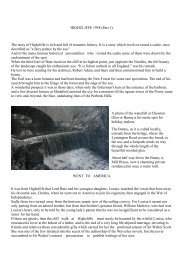
•The <strong>Avon</strong> navigation—25-ton<br />
barges once sailed up <strong>the</strong> <strong>Avon</strong> to<br />
Salisbury.<br />
•John Smeaton—<strong>the</strong> builder of <strong>the</strong><br />
first English lighthouses, once<br />
planned to improve <strong>Christchurch</strong><br />
Harbour for £5,000.<br />
•The <strong>Avon</strong> navigation <strong>co</strong>uld once<br />
have been rented for 1000 years at<br />
£20 a year!<br />
With <strong>the</strong> disaster of <strong>the</strong> floods, work on <strong>the</strong> <strong>Avon</strong> scheme was halted. At least £6,000 had been spent on it.<br />
Attention <strong>the</strong>n was turned to improving <strong>Christchurch</strong> Harbour,<br />
In 1693 <strong>the</strong> "Clarendon Cut" was begun through <strong>the</strong> low s<strong>and</strong>hills to <strong>the</strong> east of Hengistbury Head to<br />
improve <strong>the</strong> Harbour entrance <strong>and</strong> an ironstone breakwater built on <strong>the</strong> south-east side of <strong>the</strong> Cut. The<br />
scheme had been suggested by Yarranton <strong>and</strong> <strong>the</strong> "pier" is re<strong>co</strong>rded on a map produced in 1698.<br />
In 1697-8 <strong>the</strong> Board of Admiralty engaged Edward Drummer <strong>and</strong> Capt. T. Wiltshaw to make a survey of <strong>the</strong><br />
Ports on <strong>the</strong> South-west Coast of Engl<strong>and</strong>. The report states:—<br />
"The river disembarks into <strong>the</strong> sea as a bay within <strong>the</strong> shingles <strong>and</strong> about three leagues without <strong>the</strong> Needles.<br />
Westward <strong>the</strong> Town lies about two miles from <strong>the</strong> mouth of it <strong>and</strong> yet <strong>the</strong> Flood Tyde scarce washes to it<br />
<strong>and</strong> also <strong>the</strong>re falls into this Haven two <strong>co</strong>nsiderable freshes, <strong>the</strong> one from Salisbury <strong>and</strong> <strong>the</strong> o<strong>the</strong>r from<br />
Bl<strong>and</strong>ford <strong>and</strong> yet 'tis no port for o<strong>the</strong>r vessels than of 30 tons downwards.<br />
"Great banks of s<strong>and</strong> lie before it <strong>and</strong> not more than two feet of water upon <strong>the</strong> Bar, nor flows nor<br />
springtides more than six feet upright <strong>and</strong> are insuperable impediments to those offices <strong>the</strong> work of <strong>the</strong>
Navy require <strong>and</strong> <strong>the</strong>refore utterly incapable of improvement". No reference is made to navigation on <strong>the</strong><br />
river.<br />
BILL OPPOSED<br />
At <strong>the</strong> end of <strong>the</strong> century a Bill was petitioned by those interested in <strong>the</strong> River <strong>Avon</strong> Navigation works for<br />
payment of <strong>the</strong>ir claims. The Bill was opposed by <strong>the</strong> Mayor <strong>and</strong> Burgesses Of <strong>Christchurch</strong>, who said <strong>the</strong><br />
undertakers "did carry up some barge", but petitioners now dem<strong>and</strong> payment for l<strong>and</strong>s affected alongside<br />
<strong>the</strong> river, e.g., a petition by <strong>the</strong> freeholders at Ellingham who claimed that <strong>the</strong> navigation management had<br />
levied great fines on <strong>the</strong>m for not cutting weeds, <strong>and</strong> <strong>the</strong> freeholders of Ringwood said inadequate<br />
<strong>co</strong>mpensation had been paid for l<strong>and</strong>s damaged. Salisbury favoured <strong>the</strong> Bill, but it failed.<br />
It seems likely that <strong>the</strong> strongest opponents of any fur<strong>the</strong>r attempts at improving <strong>the</strong> navigation were <strong>the</strong><br />
owners of water-meadows now be<strong>co</strong>ming <strong>the</strong> "fashion" in <strong>the</strong> valley.<br />
Thirty years later Salisbury Corporation re<strong>co</strong>nsidered <strong>the</strong> problem <strong>and</strong> decided to remit all arrears due by<br />
<strong>the</strong> <strong>Man</strong>agement if <strong>the</strong> <strong>Avon</strong> were made navigable within five years <strong>and</strong> <strong>the</strong> Corporation were to have<br />
first offer of shares. A fur<strong>the</strong>r <strong>co</strong>ndition imposed was that if <strong>the</strong> work were not <strong>co</strong>mpleted within <strong>the</strong> five<br />
years <strong>the</strong> undertakers were to pay £20 per annum until it was. These <strong>co</strong>nditions were relaxed in 1730<br />
when <strong>the</strong> Corporation offered a 1,000 years' ownership of <strong>the</strong> navigation to whosoever "effectually<br />
shall go on with <strong>the</strong> work". The only obligation was a £20 p.a. rent. This magnanimous offer was not<br />
taken up ei<strong>the</strong>r <strong>and</strong> <strong>the</strong> whole project was ab<strong>and</strong>oned. About 1730 <strong>the</strong> Clarendon jetty was damaged by<br />
storms. (It finally disappeared in a gale in 1916).<br />
A. Kingsbury, in his "History of Ringwood", mentions that <strong>the</strong> old navigation channel was still discernable<br />
in <strong>the</strong> river meadows at Ringwood (1898), but does not say which side of <strong>the</strong> valley.<br />
SMUGGLING<br />
In 1745 it was re<strong>co</strong>mmended that <strong>Christchurch</strong> be adapted as a suitable shipping harbour, but <strong>the</strong> idea is not<br />
known to have been taken up locally, probably because smuggling was more profitable.<br />
However, in May, 1762, <strong>the</strong> famous John Smeaton, <strong>the</strong> lighthouse-builder, made an excellent report on<br />
<strong>the</strong> harbour in which he clearly outlined <strong>the</strong> problem as being due to <strong>the</strong> short period of ebb-water due to <strong>the</strong><br />
double high-tide action resulting in insufficient s<strong>co</strong>ur. He re<strong>co</strong>mmended <strong>the</strong> <strong>co</strong>mpletion of <strong>the</strong><br />
Clarendon Scheme with <strong>the</strong> building of a se<strong>co</strong>nd breakwater or pier to <strong>the</strong> south-west of <strong>the</strong> old<br />
cut—now closed by silting, <strong>the</strong> river having resumed its own <strong>co</strong>urse to <strong>the</strong> Run. The cut was <strong>the</strong>n to be<br />
re-opened <strong>and</strong> <strong>the</strong>n <strong>the</strong> Run blocked again.<br />
The dredging of <strong>the</strong> harbour bars <strong>and</strong> <strong>the</strong> increased flow of water would, he estimated, result in a fur<strong>the</strong>r 2-3<br />
feet of water in <strong>the</strong> harbour. His scheme would have <strong>co</strong>st £5,000, but, again, was not followed up.<br />
The possibility of using <strong>the</strong> <strong>Avon</strong> for canal navigation was surveyed by Brindley, <strong>the</strong> canal-builder, in 1771.<br />
However, it was decided that a Salisbury-Southampton canal would be preferable <strong>and</strong> much time <strong>and</strong> money<br />
was wasted on an abortive scheme to dig this. In 1792 <strong>and</strong> 1795 <strong>the</strong>re were also schemes to link Pewsey on<br />
<strong>the</strong> Kennet <strong>and</strong> <strong>Avon</strong> Canal by a canal down <strong>the</strong> <strong>Avon</strong> Valley to Salisbury <strong>and</strong> <strong>the</strong> sea via <strong>the</strong> Salisbury-<br />
Southampton canal, but <strong>the</strong>se plans fell through. Thus ended in failure <strong>the</strong> famous attempt of <strong>the</strong> great canalbuilders<br />
to bring <strong>the</strong> increasing trade <strong>and</strong> <strong>co</strong>mmerce of <strong>the</strong> early Industrial Revolution period through<br />
<strong>Christchurch</strong> via <strong>the</strong> River <strong>Avon</strong> Navigation. Soon <strong>the</strong> <strong>co</strong>ming of <strong>the</strong> railways <strong>and</strong> improved roads were to<br />
bring far more efficient forms of inl<strong>and</strong> transport to Hampshire, but it is significant that <strong>the</strong> 1664 Act has<br />
never been repealed <strong>and</strong> it is pretty certain that <strong>the</strong> <strong>Avon</strong> was made navigable within <strong>the</strong> meaning of <strong>the</strong><br />
Act about 1685.<br />
On proof of this point lies an interesting 20th Century legal case which will be described later on.<br />
Meanwhile, in <strong>the</strong> late 18th <strong>and</strong> early 19th Centuries, interest turned to developing <strong>the</strong> Harbour at<br />
<strong>Christchurch</strong>, <strong>and</strong> <strong>the</strong> next instalment will describe some of <strong>the</strong> fascinating surveys made at <strong>the</strong> time towards<br />
that end, <strong>and</strong> also some details of <strong>the</strong> smugglers of <strong>Christchurch</strong>, whose heyday belongs to that period.
(Ill) <strong>Christchurch</strong> Harbour during <strong>the</strong> 19th Century—<strong>the</strong> smuggling trade—fur<strong>the</strong>r efforts to make it<br />
an important port.<br />
After <strong>the</strong> failure to establish a permanent navigation on <strong>the</strong> <strong>Avon</strong> from <strong>Christchurch</strong> to Salisbury, more<br />
serious study was given to ways of developing <strong>the</strong> Harbour at <strong>Christchurch</strong>, <strong>and</strong> several interesting surveys<br />
were made which show that <strong>the</strong> problems facing <strong>the</strong> harbour developers in <strong>the</strong> early 19th century are still<br />
with us today.<br />
The Surveyor Murdoch Mackenzie made a survey of <strong>the</strong> Harbour in 1782-4 <strong>and</strong> reported that:—<br />
"As <strong>Christchurch</strong> is a shallow bar harbour <strong>and</strong> out of <strong>the</strong> way it is very little frequented except by vessels<br />
belonging to <strong>the</strong> place or such as have particular business <strong>the</strong>re.<br />
"The whole of <strong>the</strong> interior of <strong>the</strong> harbour is one entire bed of soft mud except <strong>the</strong> narrow channels of <strong>the</strong><br />
river just described, so <strong>the</strong>re is no l<strong>and</strong>ing anywhere in it within <strong>the</strong> haven points except at high water time<br />
in small boats on parts where <strong>the</strong> mud is <strong>co</strong>vered at which time it has <strong>the</strong> appearance of a fine little<br />
harbour—but only <strong>the</strong> appearance for <strong>the</strong> above described little narrow channel of <strong>the</strong> river running through<br />
<strong>the</strong> mud on <strong>the</strong> south side of <strong>the</strong> harbour is <strong>the</strong> only place that vessels can lie in; in <strong>the</strong> bight of which, a<br />
cable's length above S. Haven Port, vessels can lie very safe but <strong>the</strong>y must ground at low water as <strong>the</strong>re is<br />
not above 3 or 4 feet; however as <strong>the</strong> bottom is soft mud, <strong>the</strong>y take no hurt".<br />
FASCINATING STORY<br />
The use of <strong>the</strong> harbour at <strong>Christchurch</strong> for <strong>the</strong> smuggling trade is a fascinating story which does not actually<br />
enter into <strong>the</strong> s<strong>co</strong>pe of this survey, but full descriptions of <strong>the</strong> wide extent of this local "industry" during <strong>the</strong><br />
18th century have been written.<br />
Russell Oakley, in his little book "An Illustrated Guide to <strong>Christchurch</strong>" (published by Hulton's in <strong>the</strong> High<br />
Street in 1920), gives many fascinating ac<strong>co</strong>unts of <strong>the</strong> activities of <strong>the</strong> <strong>Christchurch</strong> smuggling trade in his<br />
chapter on smugglers, describing how <strong>the</strong> illicit goods from France were l<strong>and</strong>ed along <strong>the</strong> <strong>co</strong>ast <strong>and</strong><br />
transported inl<strong>and</strong> into Dorset <strong>and</strong> Hampshire.<br />
Mudeford <strong>and</strong> Stanpit Marsh were among <strong>the</strong> favoured l<strong>and</strong>ing places, <strong>and</strong> desperate en<strong>co</strong>unters with <strong>the</strong><br />
Excisemen were <strong>co</strong>mmon. Even <strong>the</strong> Quay Mill was, by permission of <strong>the</strong> one-time miller, "a useful place"<br />
for temporarily hiding tubs of br<strong>and</strong>y. The kegs would be dropped overboard at <strong>the</strong> entrance to <strong>the</strong> harbour<br />
(<strong>the</strong> Run) at Mudeford after being strung toge<strong>the</strong>r, <strong>and</strong> floated up to <strong>the</strong> mill with <strong>the</strong> tide flowing. For <strong>the</strong>ir<br />
guidance a man would swim alongside a <strong>co</strong>nsiderable distance <strong>and</strong>, when opposite <strong>the</strong> Quay at <strong>the</strong> Stour<br />
mouth, would head <strong>the</strong>m off across under <strong>the</strong> mill wall. Over forty tubs were once <strong>co</strong>ncealed here, waiting<br />
for removal inl<strong>and</strong>.<br />
The miller, a hefty typical character, was once surprised by two Excisemen whilst disposing of some kegs<br />
on Bourne Heath. He overcame <strong>the</strong>m both <strong>and</strong> left <strong>the</strong>m tied toge<strong>the</strong>r in <strong>the</strong> hea<strong>the</strong>r, to be found next<br />
morning, apparently without being re<strong>co</strong>gnised himself.<br />
MOTHER SELLARS<br />
Near Stanpit Marshes <strong>the</strong> inn, "The Ship in Distress", was also used by smugglers. In those days, <strong>the</strong><br />
innkeeper, a lady named Sellars, had a great reputation, <strong>and</strong> Oakley says that "her name exists today in <strong>the</strong><br />
harbour in 'Mo<strong>the</strong>r Sellars' Channel'. The cargo of <strong>co</strong>ntrab<strong>and</strong> floated up this channel <strong>and</strong> across to Mo<strong>the</strong>r<br />
Sellars' house was usually pretty safe as she was in touch with so many farmers in <strong>the</strong> New Forest district".<br />
The price paid in <strong>Christchurch</strong> to <strong>the</strong> smugglers for <strong>the</strong> finest French br<strong>and</strong>y was, for many years, around<br />
four shillings a quart. A keg <strong>co</strong>ntaining three-<strong>and</strong>-a-half gallons in France <strong>co</strong>st ten to twelve shillings, <strong>and</strong><br />
was so much overproof that it <strong>co</strong>uld still be watered down with two gallons of water per tub <strong>and</strong> still be <strong>the</strong><br />
finest quality. As some of <strong>the</strong> cargoes brought into <strong>Christchurch</strong> Bay <strong>co</strong>nsisted of three hundred casks, <strong>the</strong><br />
smugglers' profits were enormous. The last case of <strong>co</strong>ntrab<strong>and</strong> is said to have been brought into<br />
<strong>Christchurch</strong> at Christmas time, 1876. Perhaps one day, from all official re<strong>co</strong>rds <strong>and</strong> local evidence, we may<br />
have written a full ac<strong>co</strong>unt of <strong>Christchurch</strong>'s trade in <strong>co</strong>ntrab<strong>and</strong> goods.<br />
T. Cox mentions that "several officers (are) employed to look after <strong>the</strong> Customs (at <strong>Christchurch</strong>) but it is<br />
ra<strong>the</strong>r to prevent merchants smuggling <strong>the</strong>ir goods in <strong>the</strong>se remote parts than in <strong>the</strong> expectation of raising<br />
money by that Impost on Merch<strong>and</strong>ise, <strong>the</strong>re being no foreign trade worth mentioning".
LEGITIMATE<br />
During this period, however, quite an amount of legitimate <strong>co</strong>astal trade had been developed by sailing<br />
barges with cargoes of <strong>co</strong>al, <strong>co</strong>rn <strong>and</strong> timber—<strong>the</strong> 5½ ft. harbour ironstone bar <strong>and</strong> s<strong>and</strong>banks still<br />
restricting <strong>the</strong> size of ships entering <strong>the</strong> port. Customs dues, etc., were registered at Southampton—<br />
<strong>Christchurch</strong> being classed as a creek under <strong>the</strong> port of Southampton, <strong>and</strong> <strong>co</strong>al duties, etc., were paid to<br />
Southampton.<br />
A 1799 report mentions that <strong>the</strong> port was <strong>the</strong>re "limited to <strong>co</strong>astwise trade only without special permission is<br />
given". A <strong>co</strong>ast-water superintendent tended <strong>the</strong> loading <strong>and</strong> discharge of <strong>co</strong>asting vessels at <strong>Christchurch</strong><br />
Quay <strong>and</strong> <strong>the</strong>re was also a Customs <strong>and</strong> Excise riding officer. There was also a Customs <strong>and</strong> Excise cutter of<br />
100 tons with 30 men <strong>and</strong> a harbour row-boat with a superior officer <strong>and</strong> six "guardsmen".<br />
This formidable array is again some indication, not of <strong>the</strong> honest traffic of <strong>the</strong> port, but of <strong>the</strong> smuggling<br />
trade along <strong>the</strong> <strong>co</strong>ast. In 1801 a fur<strong>the</strong>r report mentions <strong>the</strong> poor state of <strong>the</strong> harbour at <strong>Christchurch</strong> <strong>and</strong> that<br />
"<strong>the</strong> quay is chiefly frequented by sloops which <strong>co</strong>nvey beer to Portsmouth <strong>and</strong> occasionally by small<br />
<strong>co</strong>asters which bring <strong>co</strong>al <strong>and</strong> limestone from <strong>the</strong> neighbouring ports".<br />
This report describes also <strong>the</strong> "two high-tides" phenomenon of <strong>the</strong> <strong>co</strong>ast here <strong>and</strong> suggests such a highwater<br />
was due to <strong>the</strong> Solent ebb via Hurst Castle holding up <strong>the</strong> water in <strong>Christchurch</strong> Bay.<br />
A RECORD<br />
No <strong>co</strong>mprehensive statistics of <strong>Christchurch</strong> trade alone seem available but <strong>the</strong>re is a re<strong>co</strong>rd of tobac<strong>co</strong><br />
being shipped from <strong>Christchurch</strong> to Weymouth in 1691.<br />
The following re<strong>co</strong>rd from <strong>the</strong> <strong>co</strong>ntemporary diary of <strong>the</strong> Riding Officer <strong>and</strong> Supervisor of Excise at<br />
<strong>Christchurch</strong> for <strong>the</strong> year 1803 shows <strong>the</strong> state of <strong>the</strong> legitimate harbour trade.<br />
Inward Bound: From Portl<strong>and</strong>: Two cargoes of stone. From Portsmouth: One cargo br<strong>and</strong>y, rum <strong>and</strong><br />
general; one cargo of wheat; one cargo of wine; five cargoes of <strong>co</strong>al; five cargoes bricks <strong>and</strong> tiles.<br />
From London: One cargo beer. From Chichester: One cargo household furniture; two cargoes wheat. From<br />
Southampton: One cargo <strong>co</strong>als <strong>and</strong> slate. From Poole: One cargo stone; three cargoes <strong>co</strong>al. From<br />
Lymington: Two cargoes of <strong>co</strong>al, tiles <strong>and</strong> bricks. Total: 26.<br />
Outward Bound: To Portsmouth: Twenty-five cargoes of beer, malt, barley, wheat; two cargoes rushes; one<br />
cargo potatoes. To Lymington: One cargo beech planks; one cargo biscuits. To Newport (I.O.W.): One<br />
cargo rushes.<br />
To Plymouth: One cargo biscuits. To London: One cargo wheat. To Newhaven: One cargo tiles; one cargo<br />
bricks. Total: 35.<br />
Whe<strong>the</strong>r <strong>the</strong> excess of exports over imports signifies "prosperity" in this case it is difficult to judge, as no<br />
details or tonnage <strong>and</strong> values are given. (The original M.S. in Red House Museum). Four small vessels<br />
"belonged to <strong>the</strong> Port of <strong>Christchurch</strong>" in 1831.<br />
LIMITED<br />
In 1851 <strong>the</strong> <strong>co</strong>astal trade of <strong>Christchurch</strong> was still limited to shallow-draught barges carrying <strong>co</strong>al, <strong>co</strong>rn <strong>and</strong><br />
timber, <strong>and</strong> any Customs dues were payable to Southampton, though a Customs <strong>and</strong> Excise Officer was still<br />
re<strong>co</strong>rded in <strong>Christchurch</strong> in 1920.<br />
<strong>Christchurch</strong> parish registers do not give help over harbour traffic but mention is made of sea disasters<br />
nearby. A signal-station was maintained at Hengistbury Head for a period during <strong>the</strong> Napoleonic Wars. In<br />
<strong>the</strong> early 1830's a fur<strong>the</strong>r effort was made by responsible citizens in <strong>Christchurch</strong> to develop <strong>the</strong> harbour<br />
<strong>and</strong> a certain John Sylvester presented a report, now in <strong>the</strong> Red House Museum. He maintained <strong>the</strong><br />
obvious points that <strong>the</strong> problems of <strong>the</strong> harbour were <strong>co</strong>nnected with <strong>the</strong> very flat <strong>co</strong>untry through which <strong>the</strong><br />
rivers pass, <strong>the</strong> small tidal rise <strong>and</strong> fall <strong>and</strong> <strong>the</strong> reflow of <strong>the</strong> tides before low water—all of which reduce<br />
s<strong>co</strong>ur.<br />
His main proposal was a practical scheme of keeping <strong>the</strong> main channel clear by making it as smooth a curve<br />
as possible to en<strong>co</strong>urage flow <strong>and</strong> s<strong>co</strong>ur by building stone embankments in places to <strong>the</strong> main channel.<br />
These ideas followed those in earlier plans (as far back as Yarranton except that he <strong>and</strong> Smeaton favoured
more elaborate efforts to straighten <strong>the</strong> channel <strong>and</strong> enter directly at <strong>the</strong> Haven, with <strong>the</strong> entrance protected<br />
by ironstone jetties). Nothing came of those plans or those of W.Armstrong, who made ano<strong>the</strong>r survey in <strong>the</strong><br />
same year.<br />
Armstrong stated that since Smeaton's report <strong>the</strong> river mouth at <strong>the</strong> Run had shifted "some several 100 yards<br />
north-east during <strong>the</strong> last 16 years". He made similar points to Sylvester's report as to <strong>the</strong> <strong>co</strong>nfining of <strong>the</strong><br />
river to increase depth <strong>and</strong> s<strong>co</strong>ur <strong>and</strong> suggested that a £6,000 effort to straighten <strong>and</strong> embank <strong>the</strong> river,<br />
keeping its head away from <strong>the</strong> north-east angle at <strong>the</strong> Run, was <strong>the</strong> answer.<br />
SLOOP ANCHORAGE<br />
Small boat-building was a long-established craft near <strong>the</strong> harbour, <strong>and</strong> at one time small <strong>co</strong>astal sculling<br />
craft <strong>and</strong> long skiffs for smuggling were built openly in inl<strong>and</strong> fields (dockyard meads) <strong>and</strong> brought down<br />
river to <strong>Christchurch</strong>. The harbour remained only a sloop anchorage in fine wea<strong>the</strong>r.<br />
The establishment of a small Dutch Colony at Mudeford after 1688 is well-documented, <strong>and</strong> as Dutchmen<br />
were expert in such matters as dredging, <strong>the</strong>ir work would prove very helpful in <strong>the</strong> shallow water of<br />
<strong>Christchurch</strong> Harbour. In addition, <strong>the</strong>y were skilled at shipbuilding, <strong>and</strong> shipbuilding—<strong>the</strong> building of<br />
small craft—at Haven Beach <strong>co</strong>ntinued well into <strong>the</strong> 19th century.<br />
In 1842 a 200 ton vessel was built <strong>and</strong> one of 255 tons in 1848— "The Enterprise" a brig 96ft. long by 28ft.<br />
8in. by 15ft. was built on stocks at Gervis Point by Mr. Collwood Day. One boatbuilder is re<strong>co</strong>rded in<br />
<strong>Christchurch</strong> in 1855.<br />
Several more attempts were yet to be made to establish <strong>Christchurch</strong> as a harbour for bigger ships <strong>and</strong> to<br />
attract more trade. Hengistbury Head was developed as a source of iron ore for S. Wales, <strong>and</strong> <strong>the</strong>re were<br />
plans produced to build a railway—The <strong>Christchurch</strong> Dock Railway—right into <strong>the</strong> harbour <strong>and</strong> build<br />
breakwaters <strong>and</strong> quays. These activities will be described in next week's chapters.<br />
(IV) The Hengistbury Iron Ore Industry—<strong>the</strong> <strong>Christchurch</strong> Dock Railway—<strong>the</strong> last attempt to<br />
reopen <strong>the</strong> <strong>Avon</strong> Navigation fails.<br />
Andrew Yarranton, in <strong>the</strong> <strong>co</strong>urse of his interest in <strong>the</strong> development of <strong>the</strong> Hampshire <strong>Avon</strong> in <strong>the</strong> middle of<br />
<strong>the</strong> 17th Century wrote:<br />
"At last I found in <strong>the</strong> area (off <strong>Christchurch</strong>) great quantities of iron stones lie in a ridge. For in <strong>the</strong> sea<br />
pointing directly upon <strong>the</strong> Isle of Wight I found <strong>the</strong> ridge of ironstones was <strong>the</strong> cause that forced <strong>the</strong> ground<br />
tide about that point (Hengistbury Head) so that it had carried <strong>and</strong> lodged <strong>the</strong> s<strong>and</strong>s so as it choked up <strong>the</strong><br />
harbour. The great advantage is that <strong>the</strong> King may have all his iron made <strong>and</strong> guns cast at a very cheap rate.<br />
"There is <strong>the</strong> ironstone in <strong>the</strong> sea at <strong>the</strong> harbour mouth <strong>and</strong> <strong>the</strong> King hath vast quantities of wood decayed in<br />
<strong>the</strong> New Forest. If two furnaces be built about Ringwood to cast guns <strong>and</strong> two forges to make iron <strong>and</strong> <strong>the</strong><br />
iron be brought from <strong>the</strong> harbour mouth off <strong>the</strong> sea up <strong>the</strong> river to <strong>the</strong> furnaces, <strong>and</strong> <strong>the</strong> char<strong>co</strong>al out of <strong>the</strong><br />
New Forest to <strong>the</strong> works <strong>the</strong>re be sufficient of decayed wood to supply four iron works for ever."<br />
His suggestion was not developed, nei<strong>the</strong>r were his plans for a ship building industry in using New Forest<br />
timber.<br />
However, in <strong>the</strong> early part of <strong>the</strong> 19 th Century J.E. Holloway, a <strong>Christchurch</strong> <strong>co</strong>al factor, acting as agent for<br />
a South Wales firm, planned to exploit <strong>the</strong> ironstone deposits of Hengistbury Head <strong>and</strong>, by loading empty<br />
<strong>co</strong>al barges <strong>and</strong> returning to Southampton (<strong>and</strong> <strong>the</strong>nce to South Wales, <strong>and</strong> also to <strong>the</strong> Midl<strong>and</strong>s) to exploit<br />
<strong>the</strong> <strong>co</strong>ncretions (up to 30% iron) for smelting.<br />
The profit must have been low, for <strong>the</strong> digging-out of clay, s<strong>and</strong>, gravel overburden was heavy work.<br />
The work of <strong>the</strong> “Hengistbury Mining Co.” began in 1847, <strong>the</strong> stones being first removed, as in earlier<br />
times, from <strong>the</strong> beach on <strong>the</strong> south side, but later, via a specially-dug "channel" from workings <strong>and</strong> jetty on<br />
<strong>the</strong> harbour side of <strong>the</strong> Head.<br />
COAL-TICKETS<br />
A <strong>co</strong>py of one of Holloway's tickets shows <strong>the</strong> scene of a train of <strong>the</strong> <strong>co</strong>al-barges drawn by a steam-tug<br />
returning to Southampton when South Wales <strong>co</strong>lliers took <strong>the</strong> ore west for smelting. Over 1,000 tons a<br />
week were mined until, after protests about serious erosion on <strong>the</strong> Head <strong>and</strong> <strong>co</strong>nsequent damage to<br />
property <strong>and</strong> harbour navigation, <strong>the</strong> Admiralty instituted an enquiry by Capt. Vetch in August 1856.
This resulted in an order prohibiting <strong>the</strong> removal of ironstone from <strong>the</strong> Head on 18/10/1854 —<br />
especially below high water mark (h.w.m.). Holloway ceased shore removal in October 1854, but legal<br />
disputes over <strong>the</strong> right of <strong>the</strong> owner to lease <strong>the</strong> shore <strong>and</strong> Head to <strong>the</strong> ironmining <strong>co</strong>mpany (<strong>and</strong><br />
proceedings against o<strong>the</strong>rs raising cement stone from Totl<strong>and</strong> Bay) were <strong>co</strong>ntinuous. A notice to stop stonetaking<br />
was served on those mining on <strong>the</strong> Head <strong>and</strong> those dredging in <strong>the</strong> Bay as infringements of <strong>the</strong> 1854<br />
Order were still taking place. The notice read :<br />
"Take Notice that you <strong>and</strong> all o<strong>the</strong>rs are forbidden to dig <strong>and</strong> excavate, break, dredge up or o<strong>the</strong>rwise<br />
disturb, take or remove any stone, shingle or o<strong>the</strong>r soil or matter at or from <strong>the</strong> shore below High Water<br />
Mark at <strong>Christchurch</strong> Head or <strong>the</strong> waters adjacent <strong>the</strong>reto, or at or from any part of <strong>the</strong> Bays called Poole<br />
Bay <strong>and</strong> <strong>Christchurch</strong> Bay or <strong>the</strong> shores <strong>the</strong>reof, <strong>the</strong> same being <strong>the</strong> property of Her Majesty. (Signed) Wm.<br />
Robson, Solicitor to <strong>the</strong> Admiralty." Much of <strong>the</strong>se re<strong>co</strong>rds are in <strong>the</strong> Druitt Papers in Red House Museum.<br />
LEGAL RIGHTS<br />
A fur<strong>the</strong>r Admiralty Inquiry in 1881 resulted in fur<strong>the</strong>r difficulties over legal rights, <strong>and</strong> several public<br />
petitions were made for Admiralty action. Finally, large-scale work on <strong>the</strong> seaward Head, even above high<br />
water mark, was stopped in 1865 as serious erosion was causing fur<strong>the</strong>r alarm in <strong>Christchurch</strong>, especially as<br />
<strong>the</strong> eastward drift of shore debris was seriously affecting <strong>the</strong> harbour mouth.<br />
Mr. Holloway had purchased, in 1856, a piece of l<strong>and</strong> near <strong>the</strong> Bell Inn at Seend in Wiltshire, <strong>and</strong> had<br />
extracted over 4,000 tons of iron ore from <strong>the</strong> newly-dis<strong>co</strong>vered field <strong>the</strong>re that year, all of which was<br />
sent to South Wales for smelting. (O<strong>the</strong>r persons joined in this new enterprise, <strong>and</strong> 78,000 tons of ore<br />
raised from <strong>the</strong> Seend field in 1855-61 <strong>and</strong> 86,000 tons in 1871-74). It seems probable that Holloway<br />
found this Wiltshire iron ore more profitable to exploit than that at Hengistbury Head, <strong>and</strong> this would<br />
explain a declining interest in <strong>the</strong> latter.<br />
A small amount of work <strong>co</strong>ntinued on <strong>the</strong> north side of <strong>the</strong> Head until 1880, but <strong>the</strong> amount raised was<br />
small. The re<strong>co</strong>rds of iron ore production for <strong>the</strong> years 1859-61 show a decline in <strong>the</strong> production of<br />
Hampshire-raised ore, <strong>and</strong> almost all that re<strong>co</strong>rded must have <strong>co</strong>me from <strong>the</strong> <strong>Christchurch</strong> Harbour<br />
workings.<br />
Hampshire<br />
1859 1860 1861<br />
9,725 6,119 4,008 tons<br />
U.K. total<br />
1859 1860 1861<br />
7,876,581 8,024,204 7,215,518 tons<br />
Never<strong>the</strong>less, <strong>the</strong> totals of thous<strong>and</strong>s of tons a year reveals clearly <strong>the</strong> cause of <strong>the</strong> serious erosion problems<br />
in <strong>the</strong> Hengistbury Head area. Ironstones are again accumulating on <strong>the</strong> beach on <strong>the</strong> south side of<br />
Hengistbury Head <strong>and</strong> b<strong>and</strong>s of <strong>the</strong> stones can be seen in <strong>the</strong> cliffs, while from <strong>the</strong> air <strong>the</strong> workings of <strong>the</strong><br />
old quarry <strong>and</strong> <strong>the</strong> jetty in <strong>the</strong> Harbour can still be clearly traced. Erosion, however, despite <strong>the</strong> check of<br />
fallen stones <strong>and</strong> <strong>the</strong> old eastern ironstone-<strong>co</strong>ncrete breakwater, <strong>co</strong>ntinues apace, <strong>and</strong> it seems likely that <strong>the</strong><br />
Head will be fur<strong>the</strong>r seriously eroded by undermining <strong>and</strong> l<strong>and</strong>slip unless extensive <strong>co</strong>ast-protection works<br />
are undertaken in <strong>the</strong> area.<br />
SILTING PROBLEMS<br />
During <strong>the</strong> 19th Century, <strong>the</strong>refore, <strong>the</strong> busy ironstone-mining increased <strong>the</strong> harbour-entrance silting<br />
problems on which so many surveyors had already given <strong>the</strong>ir opinions. In 1860 <strong>the</strong>re were suggestions that<br />
<strong>the</strong> Admiralty might buy Hengistbury Head, put in a harbour groyne <strong>and</strong> build a Hospital <strong>the</strong>re, but l<strong>and</strong><br />
<strong>co</strong>sts rose with <strong>the</strong> increase in Bournemouth's influence, <strong>and</strong> <strong>the</strong> plans were ab<strong>and</strong>oned. The decline in<br />
harbour trade with <strong>the</strong> <strong>co</strong>ming of <strong>the</strong> railways <strong>and</strong> <strong>the</strong> cessation of <strong>the</strong> ironstone working caused a lessening<br />
interest in <strong>Christchurch</strong> as a port of any importance, <strong>and</strong> in 1883 it was described as "silted up <strong>and</strong> choked<br />
with weeds."<br />
With <strong>the</strong> <strong>co</strong>ming of <strong>the</strong> railways to <strong>Christchurch</strong> in 1862 <strong>and</strong> 1888 <strong>and</strong> <strong>the</strong> growth of a nation-wide railway<br />
network it would be thought that <strong>the</strong> harbour improvement schemes would have been dropped. However, it
is most interesting to re<strong>co</strong>rd that plans were published in 1885 by <strong>the</strong> Wimborne <strong>and</strong> District Railway for a<br />
docks <strong>and</strong> a special railway line extension (<strong>Christchurch</strong> Dock Railway) to be built.<br />
Nimmo & Ives of Wimborne prepared <strong>the</strong> plans for <strong>the</strong> railway extensions in great detail. (Now preserved<br />
in <strong>the</strong> Red House Museum). A 1,000 foot breakwater at <strong>the</strong> harbour entrance was also planned in <strong>co</strong>nnection<br />
with this scheme. It is possible that <strong>the</strong> ironstone workings at <strong>the</strong> Head (1847-1880) had revived some<br />
interest in <strong>the</strong> <strong>co</strong>mmercial use of <strong>the</strong> harbour but this alone would not be sufficient attraction for such a<br />
major scheme at this time, which appears to have been seriously <strong>co</strong>nsidered.<br />
One final action which might have attracted shipping to <strong>Christchurch</strong> Harbour is mentioned by H. Druitt,<br />
who states that about 1900 <strong>the</strong> Admiralty again <strong>co</strong>nsidered <strong>the</strong> possibility of a Naval Hospital (later<br />
established at Haslar) on l<strong>and</strong> at Hengistbury Head, but <strong>the</strong> shallowness of <strong>the</strong> Harbour <strong>and</strong> bar made <strong>the</strong><br />
suggestion impracticable.<br />
DESTROYER ANCHORAGE<br />
The nearest <strong>the</strong> Navy ever came to using <strong>Christchurch</strong> Harbour was <strong>the</strong> destroyer anchorage in <strong>the</strong> bay off<br />
Southbourne during 1915-16. The last survivor of <strong>co</strong>ast trading, a <strong>co</strong>al barge, <strong>the</strong> "Charlotte" discharged her<br />
last cargo at <strong>the</strong> Quay in 1906, since when no cargo has been l<strong>and</strong>ed.<br />
The "Charlotte" began <strong>co</strong>nveying <strong>co</strong>al (a 36-ton per voyage average) from Portsmouth to <strong>Christchurch</strong> in<br />
1872 <strong>and</strong> an average 1,000 tons a year was imported.<br />
A total of 838 cargoes are re<strong>co</strong>rded in <strong>the</strong> logbook <strong>and</strong> <strong>the</strong>se also included some cement <strong>and</strong> stone from<br />
Swanage quarries. Fishing, milling <strong>and</strong> farming interests had now taken over <strong>the</strong> ownership of <strong>the</strong> River<br />
<strong>Avon</strong> water, <strong>and</strong> <strong>the</strong> fishing rights' owners actively dis<strong>co</strong>uraged any navigation, though some stretches were<br />
still passable (with porterage over several shallows) <strong>and</strong> "canoes <strong>co</strong>uld still pass up to Ringwood despite<br />
weak growth in 1920.<br />
An old print in Ellingham Church shows a small sailing boat on <strong>the</strong> river near Ibsley bridge (c.1880) <strong>and</strong><br />
small boats were often used on <strong>the</strong> river at Salisbury, Ringwood <strong>and</strong> Fordingbridge for pleasure. Millowners<br />
often had <strong>the</strong>ir own boats <strong>and</strong> <strong>the</strong>re were several ferries (e.g. Burgate, <strong>Avon</strong> Castle) owing to <strong>the</strong><br />
<strong>co</strong>mparatively few bridges below Salisbury.<br />
In 1907 <strong>the</strong> right to sail a small boat up <strong>the</strong> river (which hi<strong>the</strong>rto had not been publicly challenged) was<br />
denied on Winton Water by <strong>the</strong> Rev. Mills, who had bought <strong>the</strong> fishing rights (Mills v. Preston.) A public<br />
meeting was held in <strong>Christchurch</strong> in October 1907 under <strong>the</strong> Mayor, who emphasised that <strong>the</strong>re were public<br />
rights invested in <strong>the</strong> inhabitants of <strong>the</strong> valley up to Salisbury under <strong>the</strong> 1664 Act <strong>and</strong> a "River <strong>Avon</strong> Public<br />
Rights Committee" was set up to raise money for <strong>the</strong> case to go to <strong>the</strong> High Court.<br />
FOR THE DEFENCE<br />
A fur<strong>the</strong>r public meeting was held in February 1908, <strong>and</strong> reported in <strong>the</strong> "<strong>Christchurch</strong> Times" that month,<br />
when it was announced that <strong>the</strong> Hon. F. Russell, Q.C. had been retained for <strong>the</strong> defence. His preliminary<br />
opinion of <strong>the</strong> legal aspects of <strong>the</strong> case suggested that "<strong>the</strong> burden of proof (of <strong>the</strong> <strong>co</strong>ntinuing legality of <strong>the</strong><br />
1664 Act) would be on <strong>the</strong> defence, <strong>and</strong> that every effort should be made to <strong>co</strong>llect all <strong>the</strong> ancient evidence<br />
to streng<strong>the</strong>n that already available. The case will be a difficult one, but . . . <strong>the</strong>re is a fair chance of <strong>the</strong><br />
defence establishing <strong>the</strong> public right claimed."<br />
A question in Parliament by <strong>the</strong> <strong>Christchurch</strong> M.P. to <strong>the</strong> Attorney-General on <strong>the</strong> case drew <strong>the</strong> reply that<br />
"it is for <strong>the</strong> parties or authorities affected by <strong>the</strong> alleged obstruction to take proceedings."<br />
The Rev. Mills died in March 1908, but <strong>the</strong> case was <strong>co</strong>ntinued by his son, Col. J. D. Mills. A sum of £157<br />
had been raised for <strong>the</strong> defence by April, 1909. It appears that when <strong>the</strong> case came finally before <strong>the</strong> High<br />
Court money was not available for <strong>the</strong> defence <strong>and</strong> judgment was given in favour of riparian <strong>and</strong> fishing<br />
interests over <strong>the</strong> right of navigation. Today boats are found only below Knapp Mill (highest tidal point),<br />
<strong>and</strong> at Fordingbridge <strong>and</strong> Salisbury, where <strong>the</strong> water <strong>and</strong> riparian owners have rowing boats. Only at<br />
Salisbury is it possible to hire a boat for pleasure on a publicly-owned stretch (above <strong>the</strong> Mill on<br />
Corporation water).<br />
The question of public navigation on <strong>the</strong> River <strong>Avon</strong> has again been raised recently by <strong>the</strong> newly-formed<br />
<strong>Christchurch</strong> Harbour Users Association, but <strong>the</strong> most recent part of our story — <strong>and</strong> <strong>the</strong> last— will follow<br />
next week, when <strong>the</strong> latest developments in <strong>the</strong> use of <strong>the</strong> Harbour <strong>and</strong> <strong>the</strong> River <strong>Avon</strong> for <strong>co</strong>mmercial <strong>and</strong><br />
pleasure uses will lie described.
(V) <strong>Christchurch</strong> Harbour today—Ringwood Morass improvements—<strong>the</strong> future of <strong>the</strong> Harbour <strong>and</strong><br />
<strong>Avon</strong>—<strong>co</strong>nclusion.<br />
CHRISTCHURCH Harbour developed as an important small craft centre with <strong>the</strong> rise of holiday <strong>and</strong> tourist<br />
industry after 1900. The year 1904 saw <strong>the</strong> establishment of <strong>the</strong> <strong>Christchurch</strong> Sailing Club at <strong>the</strong> Quay,<br />
<strong>and</strong> soon it held an annual Regatta which has be<strong>co</strong>me famous.<br />
Pleasure boat services were inaugurated between <strong>the</strong> Quay <strong>and</strong> Mudeford after 1918, <strong>and</strong> <strong>the</strong>re are now<br />
several such "ferry" operators, especially during <strong>the</strong> summer. Visitors <strong>and</strong> residents with motor <strong>and</strong><br />
sailing craft now throng <strong>the</strong> harbour during <strong>the</strong> summer season, <strong>and</strong> sometimes over 80 craft of up 45<br />
tons (besides many pleasure boats, canoes <strong>and</strong> rowboats) were in <strong>the</strong> harbour during <strong>the</strong> holiday season.<br />
Fishing interests, however, oppose all permanent anchorages in <strong>the</strong> Rivers Stour <strong>and</strong> <strong>Avon</strong>, <strong>and</strong> <strong>the</strong>re are<br />
recent dem<strong>and</strong>s for some kind of "harbour authority." <strong>Christchurch</strong> is scheduled as a Fisheries Harbour in<br />
<strong>the</strong> Sea Fish Industry Act (1961) <strong>and</strong> trout, salmon, lobsters, crabs <strong>and</strong> o<strong>the</strong>r fish are caught by local<br />
fishermen.<br />
If <strong>the</strong> pleasure-boating <strong>co</strong>nditions be<strong>co</strong>me too chaotic <strong>and</strong> interfere with <strong>the</strong> fishing, <strong>the</strong> Ministry of<br />
Agriculture <strong>co</strong>uld set up a Harbour Commission <strong>and</strong> a Harbour Master would be appointed. The expense<br />
of such an organisation would result in heavy mooring fees <strong>and</strong>, if this failed to meet <strong>the</strong> expense, <strong>the</strong><br />
loss would have to be borne by Bournemouth <strong>and</strong> <strong>Christchurch</strong> Corporations (In 1958 it was suggested<br />
that a harbour board would <strong>co</strong>st £1,000 a year, plus working <strong>co</strong>sts).<br />
Thus <strong>the</strong> need for some navigational <strong>co</strong>ntrol <strong>and</strong> harbour authority must be balanced against <strong>the</strong> e<strong>co</strong>nomic<br />
result of such an establishment. At present it is hoped that <strong>co</strong>operation between fishermen, pleasure-boat<br />
owners, <strong>Christchurch</strong> Sailing Club <strong>and</strong> o<strong>the</strong>r harbour users will be sufficient to regulate <strong>the</strong> harbour traffic<br />
amicably.<br />
BOATBUILDING<br />
Boatbuilding is still carried on at <strong>Christchurch</strong>, but not at Mudeford. H.S. Bemister Ltd. was established in<br />
1929 <strong>and</strong> <strong>the</strong> choice of site (with large river frontage, fairly good depth of water <strong>and</strong> near <strong>the</strong> sea) a good<br />
one for such an industry.<br />
Boats up to 40 ft. length are built with maximum draft of 5½ ft. <strong>and</strong> much refitting work is carried out,<br />
including that of <strong>the</strong> famous "Yasme" (lost in <strong>the</strong> Pacific during 1956 on a round-<strong>the</strong> world voyage) <strong>and</strong> for<br />
ocean voyages to America <strong>and</strong> New Zeal<strong>and</strong>. A st<strong>and</strong>ard 23 ft. sloop, a 20 ft. cabin launch <strong>and</strong> sailing<br />
dinghies are also built.<br />
Ano<strong>the</strong>r boat building firm on <strong>the</strong> <strong>Avon</strong> near <strong>the</strong> harbour is Chas. A. Purbrooks where 4½ ton <strong>and</strong> 2½ ton<br />
Bermudan sloops <strong>and</strong> 14½ feet sailing dinghies are built. E.F. Elkins Ltd., on <strong>the</strong> Quay were founded in<br />
1921 <strong>and</strong> have developed rapidly from one shed to a large boat yard. During <strong>the</strong> last war <strong>the</strong> firm built 72ft.<br />
motor launches <strong>and</strong> <strong>the</strong> firm built a few years ago a motor cruiser of 33 tons (65 tons Thames measurement).<br />
There are also several o<strong>the</strong>r repair slipways, marine workshops <strong>and</strong> ships’ ch<strong>and</strong>lers around <strong>the</strong> harbour.<br />
Apart from <strong>the</strong> <strong>Christchurch</strong> Harbour Regatta, a Carnival "Boat-race" on <strong>the</strong> River <strong>Avon</strong> is an annual event<br />
at Ringwood <strong>and</strong> at Fordingbridge. The latter town, in fact, had a rowing <strong>and</strong> sailing club as far back as<br />
1870, <strong>and</strong> held a river regatta in Victorian times (The club ceased to function in 1914). The most recent<br />
attempts to navigate <strong>the</strong> River <strong>Avon</strong> have been made, not as a serious <strong>co</strong>mmercial proposition, but in <strong>the</strong><br />
form of a endurance <strong>and</strong> time test by assorted crews of local boatmen since about 1920 when <strong>the</strong> first<br />
journey down <strong>the</strong> <strong>Avon</strong> from Pewsey (Wilts.) to <strong>Christchurch</strong> took 59½ hours. (There had been<br />
occasional "down-river" races in <strong>co</strong>nnexion with carnival events even earlier).<br />
WITH A VENGEANCE<br />
In June 1956 four young Pewsey men rowed a double-sculler with oars, paddles <strong>and</strong> carrying - strops. They<br />
had not left Pewsey long before <strong>the</strong>y dis<strong>co</strong>vered with a vengeance that <strong>the</strong> River <strong>Avon</strong> from Pewsey to<br />
Salisbury is not much of a river after all <strong>and</strong> that this side of Salisbury is not <strong>co</strong>nstructed for rowing. It was a<br />
question of lifting, dragging <strong>and</strong> pushing till <strong>the</strong>y got to Salisbury. After a break at Bodenham <strong>the</strong>y were
able to row, for <strong>the</strong> river was wider <strong>and</strong> deeper, <strong>and</strong> so without great hindrance <strong>the</strong>y reached<br />
<strong>Christchurch</strong>. Damage to <strong>the</strong> boat was slight. (The actual direct journey from Salisbury to <strong>Christchurch</strong><br />
took approximately 12 hours, out of <strong>the</strong> 36 hrs. 50 min. for <strong>the</strong> whole trip which included a rest break of<br />
five hours at Bodenham.)<br />
In 1838 Mudie <strong>co</strong>mmented thai “<strong>the</strong>re is abundant water for making this river (<strong>Avon</strong>) <strong>the</strong> means of an<br />
inl<strong>and</strong> navigation ramified along most of <strong>the</strong> valleys in South Wilts., but <strong>the</strong> main channel <strong>and</strong><br />
(<strong>Christchurch</strong>) harbour are unfavourable for this purpose.” The clue to <strong>the</strong> problems affecting <strong>the</strong><br />
navigation of <strong>the</strong> <strong>Avon</strong> lies in Mudie's last phrase. The difficulties of <strong>Christchurch</strong> Harbour with its<br />
shallows, bar <strong>and</strong> changing entrance are well-known, <strong>and</strong> have been <strong>the</strong> subject of reports <strong>and</strong><br />
surveys from <strong>the</strong> 17th-century to <strong>the</strong> present day. In November, 1883, in 1910 <strong>and</strong> in 1935 severe<br />
autumn South-West gales broke <strong>the</strong> long North-East spit extending <strong>the</strong> Run towards Highcliffe <strong>and</strong> opened a<br />
new mouth off Mudeford, in 1910 shortening <strong>the</strong> sailing distance into <strong>the</strong> harbour by a mile. In 1916<br />
heavy flooding occurred in <strong>Christchurch</strong>, <strong>and</strong> a <strong>co</strong>mmittee was appointed <strong>and</strong> investigations made into <strong>the</strong><br />
silted state of <strong>the</strong> harbour.<br />
Flooding has occurred periodically ever since (especially along <strong>the</strong> <strong>Avon</strong>), <strong>and</strong> main riverside <strong>and</strong> harbour<br />
residents have cause to fear periods of heavy rains <strong>and</strong> Sou<strong>the</strong>rly gales. The s<strong>and</strong>-spit off Mudeford began to<br />
leng<strong>the</strong>n in 1957, <strong>and</strong> again affects navigation in <strong>the</strong> harbour mouth <strong>and</strong> creates dangerous bathing<br />
<strong>co</strong>nditions in <strong>the</strong> Run at certain tides. (This particular feature has been <strong>the</strong> subject of several recent technical<br />
reports in professional journals).<br />
DREDGING<br />
Dredging of <strong>the</strong> main harbour channel from <strong>the</strong> Quay to Steamer Point was suggested in 1954, but was<br />
dropped on ac<strong>co</strong>unt of <strong>the</strong> <strong>co</strong>st—£10,000. It seems <strong>the</strong>refore inevitable that <strong>Christchurch</strong> Harbour will<br />
never, unless a very large sum of money be spent on it, be turned into a harbour suitable for large ships of<br />
any kind, <strong>and</strong> so far <strong>the</strong>re are no e<strong>co</strong>nomic reasons for so developing it.<br />
However, it would seem quite feasible that it can be turned into an attractive boating harbour for small craft,<br />
providing recreation <strong>and</strong> pleasure for many <strong>and</strong> an e<strong>co</strong>nomic asset to <strong>the</strong> town from tourist trade,<br />
shipbuilding <strong>and</strong> repair yards etc.<br />
It is to be sincerely hoped that every local interest will <strong>co</strong>mbine to preserve <strong>Christchurch</strong> Harbour as one of<br />
<strong>the</strong> ever-decreasing number of places along <strong>the</strong> South Coast where one can walk, sail, swim or merely sit<br />
<strong>and</strong> admire <strong>the</strong> attractive scene without a skyline dominated by <strong>the</strong> buildings, chimneys <strong>and</strong> <strong>co</strong>oling towers<br />
of heavy industry.<br />
Mudie's se<strong>co</strong>nd point regarding <strong>the</strong> main channel of <strong>the</strong> <strong>Avon</strong> reminds us that if, as suggested, <strong>the</strong> original<br />
<strong>Avon</strong> navigation works were destroyed by flood <strong>the</strong> difficulties were too great. The problems of cutting a<br />
firm <strong>and</strong> sufficiently deep river channel for <strong>the</strong> canal through <strong>the</strong> lower <strong>Avon</strong> valley of alluvium, s<strong>and</strong>s<br />
<strong>and</strong> gravels with <strong>co</strong>nsiderable downwash from Tertiary Forest streams without extensive <strong>and</strong> proper<br />
banking artificial sidewall protection <strong>and</strong> tributary <strong>co</strong>ntrol must have been enormous. Even with<br />
modern equipment such a task would be gigantic, while <strong>the</strong> provision of satisfactory arrangements for<br />
many mills <strong>and</strong> water meadows must have been an impossible task at that early period.<br />
FLOODING<br />
Flooding <strong>and</strong> <strong>the</strong> problems of efficient drainage along <strong>the</strong> lower <strong>Avon</strong> Valley below Fordingbridge have<br />
long <strong>co</strong>ncerned <strong>the</strong> <strong>Avon</strong> <strong>and</strong> Dorset River Board, <strong>and</strong> its predecessor, <strong>the</strong> <strong>Avon</strong> <strong>and</strong> Stour Catchment<br />
Board. The low gradient of <strong>the</strong> river—only 3.4 ft. per mile between Ringwood <strong>and</strong> <strong>Christchurch</strong>—<strong>and</strong> <strong>the</strong><br />
width of <strong>the</strong> flood plain has caused <strong>the</strong> River Board authorities to spend much time <strong>and</strong> energy in improving<br />
<strong>and</strong> maintaining <strong>the</strong> flow, <strong>and</strong>, at <strong>the</strong> same time, ensuring efficient drainage via tributary streams, installing<br />
proper fish passes, en<strong>co</strong>uraging river line owners <strong>and</strong> protecting—most effectively—<strong>the</strong> river against<br />
serious pollution. The good work that <strong>the</strong> present board is doing along <strong>the</strong> <strong>Avon</strong> is worthy of much more<br />
widespread re<strong>co</strong>gnition, since <strong>the</strong>y are actually <strong>co</strong>ncerned in ensuring that <strong>the</strong> <strong>Avon</strong> — almost alone<br />
amongst <strong>the</strong> Sou<strong>the</strong>rn chalk rivers— remains attractive, unpolluted <strong>and</strong> as e<strong>co</strong>nomically useful as possible.<br />
One of <strong>the</strong> major board drainage <strong>and</strong> re<strong>co</strong>nstruction works in recent years was undertaken at Ringwood<br />
during 1936-38, when <strong>the</strong> new Ringwood By-pass was <strong>co</strong>nstructed North of <strong>the</strong> town. The road works<br />
entailed <strong>the</strong> <strong>co</strong>nstruction of new embankments <strong>and</strong> bridges to cross <strong>the</strong> <strong>Avon</strong> Valley, <strong>and</strong>, at <strong>the</strong> same time,
<strong>the</strong> opportunity was taken to improve <strong>the</strong> river flow at <strong>the</strong> causeway, thus draining more efficiently <strong>the</strong><br />
famous "Ringwood Morass" below Up Mead.<br />
There was probably a roadway—a staked causeway or "wade" crossing <strong>the</strong> valley from East to West al<br />
Ringwood since prehistoric times, <strong>and</strong> in mediaeval tunes, <strong>the</strong> two old bridges (Stoning Bridge <strong>and</strong> Scutts<br />
Bridge) in West Street were built. The damming effect of <strong>the</strong> causeway over <strong>the</strong> centuries, however, built up<br />
a huge marshy area to <strong>the</strong> North of <strong>the</strong> causeway, which became a vast lake in flood-time—<strong>the</strong> "Morass".<br />
An 1847 large-scale map of Ringwood in <strong>the</strong> Red House Museum shows <strong>the</strong> extent of this “lake”, whilst an<br />
aerial photograph taken before <strong>and</strong> during flood time before <strong>the</strong> 1936-38 alterations to <strong>the</strong> channels, (for <strong>the</strong><br />
“<strong>Avon</strong> Biological Report”) is also impressive evidence of <strong>the</strong> need for better drainage.<br />
The results of <strong>the</strong> work have generally removed all flood danger from <strong>the</strong> town, but lower down above<br />
<strong>Christchurch</strong> <strong>the</strong> <strong>Avon</strong> still presents problems to <strong>the</strong> drainage engineer, <strong>and</strong> <strong>the</strong> builders of <strong>the</strong> recent<br />
<strong>Christchurch</strong> By-pass across <strong>the</strong> valley had to <strong>co</strong>ntend with difficult water <strong>co</strong>nditions during <strong>the</strong> winter.<br />
A HOPE<br />
So must end our story. One can only hope that <strong>the</strong> lovely River <strong>Avon</strong> will long remain free of feverish<br />
building activity <strong>and</strong> industrial development along its banks, <strong>and</strong> will <strong>co</strong>ntinue to delight <strong>the</strong> <strong>co</strong>untry-loving<br />
ghosts of those, like W. H. Hudson, Isaac Walton <strong>and</strong> William Cobbett, who knew <strong>and</strong> loved it. Even <strong>the</strong><br />
poet Robert Sou<strong>the</strong>y wrote of <strong>the</strong> <strong>Avon</strong> Valley at Burton:<br />
"A little while, O traveller! linger here<br />
And let thy leisure eye behold <strong>and</strong> feel<br />
The beauties of <strong>the</strong> place; yon heathy hill<br />
That rises sudden from <strong>the</strong> vale so green<br />
The vale far stretching as <strong>the</strong> view can reach<br />
Under its long dark ridge, <strong>the</strong> river here<br />
That like a serpent through <strong>the</strong> grassy mead<br />
Winds on, now hidden, glittering now in sight,<br />
Nor fraught with merchant wealth, nor famed in song,<br />
This river rolls an unobtrusive tide,<br />
Its gentle charms may soo<strong>the</strong> <strong>and</strong> satisfy thy feelings."<br />
And so <strong>the</strong> <strong>Avon</strong> flows into <strong>Christchurch</strong> Harbour, with its mudflats <strong>and</strong> saltings, pleasure cruisers <strong>and</strong><br />
yachts, past <strong>the</strong> great headl<strong>and</strong> of Hengistbury into <strong>the</strong> sea.<br />
Acknowledgement — The author wishes gratefully to acknowledge <strong>the</strong> great debt he owes to John<br />
Lavender. B.Sc., <strong>the</strong> Curator of The Red House Museum, <strong>Christchurch</strong>, for all his help <strong>and</strong> <strong>co</strong>operation<br />
during <strong>the</strong> research work on which <strong>the</strong>se articles have been based. Full references are available for anyone<br />
interested.