BMP Retrofit Application - Tahoe Regional Planning Agency â TRPA
BMP Retrofit Application - Tahoe Regional Planning Agency â TRPA
BMP Retrofit Application - Tahoe Regional Planning Agency â TRPA

Create successful ePaper yourself
Turn your PDF publications into a flip-book with our unique Google optimized e-Paper software.
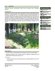
BEST MANAGEMENT PRACTICES (<strong>BMP</strong>s)<br />
RETROFIT APPLICATION<br />
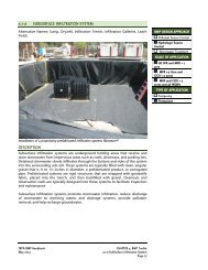
Lake <strong>Tahoe</strong> is losing its clarity at a rate of over a foot a year. Research has found that the addition of sediment and<br />
nutrients such as nitrogen and phosphorus to Lake <strong>Tahoe</strong> promotes algal blooms that contribute to this loss of water<br />
clarity. Non-point source (NPS) pollution, or pollution originating from many diffuse sources, is the main contributor<br />
to this decline. NPS pollution occurs when rain or snowmelt causes overland flow, picking up various pollutants from<br />
the ground’s surface and transporting them directly into the surface waters that lead to Lake <strong>Tahoe</strong>.<br />
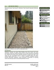
Pursuant to subsection 60.4.6.A of the <strong>TRPA</strong> Code of Ordinances, all property owners in the <strong>Tahoe</strong> Basin are<br />
required to install infiltration facilities designed to accommodate the volume of runoff from the twenty year/one hour<br />
storm, which is approximately one inch of precipitation in an hour. These infiltration facilities are Best Management<br />
Practices (<strong>BMP</strong>s), or structural and nonstructural practices proven effective in soil erosion control and management<br />
of surface runoff.<br />
All property owners in the Lake <strong>Tahoe</strong> basin need to implement <strong>BMP</strong>s, whether they own residential or commercial<br />
properties. The watersheds in the <strong>Tahoe</strong> Basin were prioritized for <strong>BMP</strong> implementation based on various factors<br />
including soil erodability, steepness of terrain, ratio of development to undisturbed land, and relative inputs of<br />
nutrients and sediment from the watershed. Utilizing this data, the watersheds were determined to be Priority One,<br />
Two or Three.<br />
Property owners in Priority One watersheds were required under subsection 60.4.4.A of the <strong>TRPA</strong> Code of<br />
Ordinances to implement <strong>BMP</strong>s on their property by October 15, 2000. Subsequent target dates for full<br />
implementation of <strong>BMP</strong>s are October 15, 2006 for property owners in Priority Two watersheds, and October 15, 2008<br />
for property owners in Priority Three watersheds. You can find out the priority of the watershed you are in by going<br />
online to www.trpa.org.
<strong>BMP</strong> RETROFIT APPLICATION<br />
Applicant<br />
Mailing Address City State<br />
Zip Code Email Phone FAX<br />
Representative or Agent<br />
Mailing Address City State<br />
Zip Code Email Phone FAX<br />
Owner<br />
Same as Applicant<br />
Mailing Address City State<br />
Zip Code Email Phone FAX<br />
Project Location/Assessor’s Parcel Number (APN)<br />
Street Address Subdivision Lot #<br />
County<br />
Previous APN<br />
(if changed by county assessor since 1987)<br />
Existing Use on Property 1 :<br />
Detailed Description of <strong>BMP</strong> <strong>Retrofit</strong> 2 (Attach additional sheets if necessary):<br />
<strong>BMP</strong> <strong>Retrofit</strong> permits are not a verification of land coverage, land capability, or use, nor are they a conceptual<br />
approval of any future project. Land coverage cannot be verified, transferred or banked through a <strong>BMP</strong><br />
<strong>Retrofit</strong> permit. These verifications require the submittal of a separate application to <strong>TRPA</strong> for review and<br />
approval.<br />
1 Please note that existing use may influence the type of <strong>BMP</strong> <strong>Retrofit</strong> required.<br />
2 THIS APPLICATION IS ONLY FOR PROJECTS IN WHICH THE MAIN PURPOSE IS <strong>BMP</strong> RETROFIT. All other<br />
projects must go through appropriate <strong>TRPA</strong> application procedures.
DECLARATION:<br />
I hereby declare under penalty of perjury that this application and all information submitted as part of this application is true and accurate to the<br />
best of my knowledge. I am the owner of the subject property, or have been authorized in writing by the owner(s) of the subject property to<br />
represent this application, and I have obtained authorization to submit this application from any other necessary parties holding an interest in<br />
the subject property. I understand it is my obligation to obtain such authorization, and I further understand that <strong>TRPA</strong> accepts no responsibility<br />
for informing these parties or obtaining their authorization. I understand that should any information or representation submitted in connection<br />
with this application be inaccurate, erroneous, or incomplete, <strong>TRPA</strong> may rescind any approval or take other appropriate action. I hereby<br />
authorize <strong>TRPA</strong> to access the property for the purpose of site visits. I understand that additional information may be required by <strong>TRPA</strong> to<br />
review this project. (Edited 7/10)<br />
Signature: (Original signature required.)<br />
Person Preparing <strong>Application</strong><br />
At<br />
County<br />
Date:<br />
AUTHORIZATION FOR REPRESENTATION (Original signatures required):<br />
The following person(s) own the subject property (Assessor’s Parcel Number(s)<br />
therein to make application to <strong>TRPA</strong>:<br />
) or have sufficient interest<br />
Print Owner(s) Name(s):<br />
I/We authorize<br />
to act as my/our representative in connection with<br />
this application to <strong>TRPA</strong> for the subject property and agree to be bound by said representative. I understand that additional information may<br />
be required by <strong>TRPA</strong> beyond that submitted by my representative, to review this project. Any cancellation of this authorization shall not be<br />
effective until receipt of written notification of same by <strong>TRPA</strong>. I also understand that should any information or representation submitted in<br />
connection with this application be incorrect or untrue, <strong>TRPA</strong> may rescind any approval or take other appropriate action. I further accept that if<br />
this project is approved, I, as the permittee, will be held responsible for any and all permit conditions.<br />
Owner(s) Signature(s): (Original signature required.)<br />
Date:<br />
Date:<br />
FOR OFFICE USE ONLY<br />
Date Received:<br />
By:<br />
Fee: N/A; <strong>Application</strong> fees will be waived if the owner installs ALL required <strong>BMP</strong>s on the subject property 3 .<br />
Comments:<br />
3 <strong>TRPA</strong>’s <strong>BMP</strong> <strong>Retrofit</strong> Program is funded through various grants from the States of Nevada and California.
<strong>BMP</strong> RETROFIT APPLICATION CHECKLIST<br />
APPLICATIONS LACKING ANY OF THE FOLLOWING ITEMS WILL NOT BE ACCEPTED. <strong>TRPA</strong> OR YOUR LOCAL JURISDICTION MAY<br />
REQUIRE ADDITIONAL INFORMATION ABOVE AND BEYOND THE CHECKLIST ITEMS TO REVIEW THIS APPLICATION.<br />
Each item and number corresponds to <strong>TRPA</strong>’s Master Checklist available at our offices or online at www.trpa.org. Click<br />
“Permits & Documents” and look for the Master Checklist under “other documents.” Refer to the Master Checklist for<br />
more information on any item.<br />
PROJECT NAME:<br />
CURRENT ASSESSOR’S PARCEL NUMBER (APN): ____________________________________________________________<br />
PREVIOUS ASSESSOR’S PARCEL NUMBER (APN): ____________________________________________________________<br />
PRIORITY WATERSHED: 1 2 3 (If you are unsure, go to www.trpa.org)<br />
Applicant<br />
<strong>TRPA</strong><br />
_____ _____ 1. Complete <strong>Application</strong> with original signed authorization and checklist.<br />
_____ _____ 2.. Three (3) Site Plans, minimum 11” x 17” showing the following:<br />
_____ _____ a. Parcel boundaries.<br />
_____ _____ b. Map scale and north arrow.<br />
_____ _____ c. Assessor’s Parcel Number (APN) and property address.<br />
_____ _____ d. Location and description of all <strong>BMP</strong>s to be implemented.<br />
_____ _____ e. Delineation of land capability districts.<br />
_____ _____ f. Location of all trees greater than 6” diameter at breast height (dbh), including which, if any,<br />
trees are proposed to be removed.<br />
_____ _____ g. Existing coverage (building footprint, driveway, walkways).<br />
_____ _____ h. All major utilities (sewer, water, gas, telephone, and electricity) must be clearly marked.<br />
_____ _____ 3. For excavations greater than 5 feet in depth, a soils/hydrologic scoping report. A scoping report may also be<br />
required when evaluations of depth to groundwater or an impermeable layer such as bedrock, a hardpan or<br />
fragipan are needed to properly design and implement <strong>BMP</strong>s.<br />
______ ______ 4. Copy of current assessors parcel map or site vicinity map.<br />
_____ _____ 5. Engineer-stamped plans and calculations for the following (if applicable). Please note that this is not a<br />
comprehensive list. Other complex <strong>BMP</strong> designs may require engineered plans:<br />
_____ _____ a. Retaining walls more than three feet in height.<br />
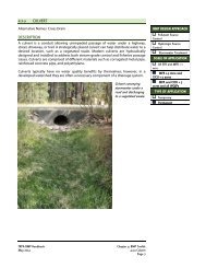
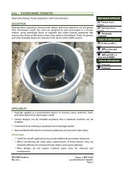
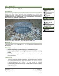
_____ _____ b. Storm water treatment systems (i.e. sand/oil separator).<br />
_____ _____ c Infiltration basins.<br />
_____ _____ d. Infiltration systems capturing runoff from areas greater than 2,500 square feet.
_____ _____ e. Subsurface conveyance systems (piping) and drop inlets.<br />
_____ _____ f. Extensive grade alterations.<br />
_____ _____ 6. Letter of permission or permit, if necessary, from the local jurisdiction in which the work is proposed to be done.<br />
_____ _____ 7. Calculations indicating that the 20 year/1 hour storm will be infiltrated by proposed <strong>BMP</strong>s (1 inch of water from all<br />
impervious surfaces)(Go to www.trpa.org for an infiltration spreadsheet to assist with this effort).<br />
_____ _____ 8 Location of stream environment zone (SEZ) within ¼-mile of the project area.<br />
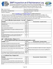
_____ _____ 9. Copy of <strong>BMP</strong> Maintenance and Monitoring Plan for commercial and public service properties ONLY.<br />
_____ _____ 10. Project approval from the local utility district.<br />
Note: If you have any questions, feel free to contact <strong>TRPA</strong> by mail or phone at PO Box 5310 Stateline, NV 89449;<br />
(775) 588-4547.