Topographic Map Symbols - Alabama Maps
Topographic Map Symbols - Alabama Maps
Topographic Map Symbols - Alabama Maps

Create successful ePaper yourself
Turn your PDF publications into a flip-book with our unique Google optimized e-Paper software.
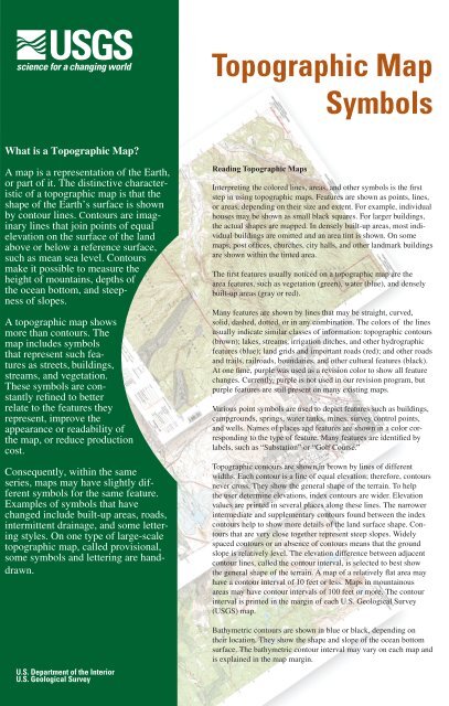
<strong>Topographic</strong> <strong>Map</strong><br />
<strong>Symbols</strong><br />
What is a <strong>Topographic</strong> <strong>Map</strong>?<br />
A map is a representation of the Earth,<br />
or part of it. The distinctive characteristic<br />
of a topographic map is that the<br />
shape of the Earth’s surface is shown<br />
by contour lines. Contours are imaginary<br />
lines that join points of equal<br />
elevation on the surface of the land<br />
above or below a reference surface,<br />
such as mean sea level. Contours<br />
make it possible to measure the<br />
height of mountains, depths of<br />
the ocean bottom, and steepness<br />
of slopes.<br />
A topographic map shows<br />
more than contours. The<br />
map includes symbols<br />
that represent such features<br />
as streets, buildings,<br />
streams, and vegetation.<br />
These symbols are constantly<br />
refined to better<br />
relate to the features they<br />
represent, improve the<br />
appearance or readability of<br />
the map, or reduce production<br />
cost.<br />
Consequently, within the same<br />
series, maps may have slightly different<br />
symbols for the same feature.<br />
Examples of symbols that have<br />
changed include built-up areas, roads,<br />
intermittent drainage, and some lettering<br />
styles. On one type of large-scale<br />
topographic map, called provisional,<br />
some symbols and lettering are handdrawn.<br />
U.S. Department of the Interior<br />
U.S. Geological Survey<br />
Reading <strong>Topographic</strong> <strong>Map</strong>s<br />
Interpreting the colored lines, areas, and other symbols is the first<br />
step in using topographic maps. Features are shown as points, lines,<br />
or areas, depending on their size and extent. For example, individual<br />
houses may be shown as small black squares. For larger buildings,<br />
the actual shapes are mapped. In densely built-up areas, most individual<br />
buildings are omitted and an area tint is shown. On some<br />
maps, post offices, churches, city halls, and other landmark buildings<br />
are shown within the tinted area.<br />
The first features usually noticed on a topographic map are the<br />
area features, such as vegetation (green), water (blue), and densely<br />
built-up areas (gray or red).<br />
Many features are shown by lines that may be straight, curved,<br />
solid, dashed, dotted, or in any combination. The colors of the lines<br />
usually indicate similar classes of information: topographic contours<br />
(brown); lakes, streams, irrigation ditches, and other hydrographic<br />
features (blue); land grids and important roads (red); and other roads<br />
and trails, railroads, boundaries, and other cultural features (black).<br />
At one time, purple was used as a revision color to show all feature<br />
changes. Currently, purple is not used in our revision program, but<br />
purple features are still present on many existing maps.<br />
Various point symbols are used to depict features such as buildings,<br />
campgrounds, springs, water tanks, mines, survey control points,<br />
and wells. Names of places and features are shown in a color corresponding<br />
to the type of feature. Many features are identified by<br />
labels, such as “Substation” or “Golf Course.”<br />
<strong>Topographic</strong> contours are shown in brown by lines of different<br />
widths. Each contour is a line of equal elevation; therefore, contours<br />
never cross. They show the general shape of the terrain. To help<br />
the user determine elevations, index contours are wider. Elevation<br />
values are printed in several places along these lines. The narrower<br />
intermediate and supplementary contours found between the index<br />
contours help to show more details of the land surface shape. Contours<br />
that are very close together represent steep slopes. Widely<br />
spaced contours or an absence of contours means that the ground<br />
slope is relatively level. The elevation difference between adjacent<br />
contour lines, called the contour interval, is selected to best show<br />
the general shape of the terrain. A map of a relatively flat area may<br />
have a contour interval of 10 feet or less. <strong>Map</strong>s in mountainous<br />
areas may have contour intervals of 100 feet or more. The contour<br />
interval is printed in the margin of each U.S. Geological Survey<br />
(USGS) map.<br />
Bathymetric contours are shown in blue or black, depending on<br />
their location. They show the shape and slope of the ocean bottom<br />
surface. The bathymetric contour interval may vary on each map and<br />
is explained in the map margin.
BATHYMETRIC FEATURES<br />
Area exposed at mean low tide; sounding<br />
datum line***<br />
Channel***<br />
Sunken rock***<br />
BOUNDARIES<br />
National<br />
State or territorial<br />
County or equivalent<br />
Civil township or equivalent<br />
Incorporated city or equivalent<br />
Federally administered park,<br />
reservation, or monument (external)<br />
Federally administered park,<br />
reservation, or monument (internal)<br />
State forest, park, reservation, or<br />
monument and large county park<br />
Forest Service administrative area*<br />
Forest Service ranger district*<br />
National Forest System land status,<br />
Forest Service lands*<br />
National Forest System land status,<br />
non-Forest Service lands*<br />
Small park (county or city)<br />
BUILDINGS AND RELATED FEATURES<br />
Building<br />
School; house of worship<br />
Athletic field<br />
Built-up area<br />
Forest headquarters*<br />
Ranger district office*<br />
Guard station or work center*<br />
Racetrack or raceway<br />
Airport, paved landing strip,<br />
runway, taxiway, or apron<br />
Unpaved landing strip<br />
Well (other than water), windmill or wind generator<br />
Tanks<br />
Covered reservoir<br />
Gaging station<br />
Located or landmark object (feature as labeled)<br />
Boat ramp or boat access*<br />
Roadside park or rest area<br />
Picnic area<br />
Campground<br />
Winter recreation area*<br />
Cemetery<br />
Cem<br />
COASTAL FEATURES<br />
Foreshore flat<br />
Coral or rock reef<br />
Rock, bare or awash; dangerous<br />
to navigation<br />
Group of rocks, bare or awash<br />
Exposed wreck<br />
Depth curve; sounding<br />
Breakwater, pier, jetty, or wharf<br />
Seawall<br />
Oil or gas well; platform<br />
CONTOURS<br />
<strong>Topographic</strong><br />
Index 6000<br />
Approximate or indefinite<br />
Intermediate<br />
Approximate or indefinite<br />
Supplementary<br />
Depression<br />
Cut<br />
Fill<br />
Continental divide<br />
Bathymetric<br />
Index***<br />
Intermediate***<br />
Index primary***<br />
Primary***<br />
Supplementary***<br />
CONTROL DATA AND MONUMENTS<br />
Principal point**<br />
U.S. mineral or location monument<br />
USMM 438<br />
River mileage marker<br />
Mile<br />
69<br />
Boundary monument<br />
Third-order or better elevation,<br />
BM<br />
with tablet<br />
9134<br />
Third-order or better elevation,<br />
recoverable mark, no tablet<br />
5628<br />
With number and elevation 67<br />
4567<br />
Horizontal control<br />
Third-order or better, permanent mark Neace<br />
With third-order or better elevation<br />
BM<br />
52<br />
With checked spot elevation<br />
1012<br />
Coincident with found section corner<br />
Unmonumented**<br />
Cactus<br />
18<br />
23
CONTROL DATA AND MONUMENTS – continued<br />
Vertical control<br />
Third-order or better elevation, with tablet<br />
Third-order or better elevation,<br />
recoverable mark, no tablet<br />
Bench mark coincident with found<br />
section corner<br />
Spot elevation<br />
GLACIERS AND PERMANENT SNOWFIELDS<br />
Contours and limits<br />
Formlines<br />
Glacial advance<br />
Glacial retreat<br />
BM<br />
5280<br />
BM<br />
528<br />
5280<br />
LAND SURVEYS<br />
Public land survey system<br />
Range or Township line<br />
Location approximate<br />
Location doubtful<br />
Protracted<br />
Protracted (AK 1:63,360-scale)<br />
Range or Township labels<br />
R1E T2N R3W T4S<br />
Section line<br />
Location approximate<br />
Location doubtful<br />
Protracted<br />
Protracted (AK 1:63,360-scale)<br />
Section numbers 1 - 36 1 - 36<br />
Found section corner<br />
Found closing corner<br />
Witness corner<br />
Meander corner<br />
Weak corner*<br />
Other land surveys<br />
Range or Township line<br />
Section line<br />
Land grant, mining claim, donation land<br />
claim, or tract<br />
Land grant, homestead, mineral, or<br />
other special survey monument<br />
Fence or field lines<br />
MARINE SHORELINES<br />
Shoreline<br />
Apparent (edge of vegetation)***<br />
Indefinite or unsurveyed<br />
MINES AND CAVES<br />
Quarry or open pit mine<br />
Gravel, sand, clay, or borrow pit<br />
Mine tunnel or cave entrance<br />
Mine shaft<br />
Prospect<br />
Tailings<br />
Mine dump<br />
Former disposal site or mine<br />
7523<br />
WC<br />
MC<br />
PROJECTION AND GRIDS<br />
Neatline 39˚15’<br />
90˚37’30”<br />
Graticule tick 55’<br />
Graticule intersection<br />
Datum shift tick<br />
State plane coordinate systems<br />
Primary zone tick<br />
Secondary zone tick<br />
Tertiary zone tick<br />
Quaternary zone tick<br />
Quintary zone tick<br />
Universal transverse metcator grid<br />
UTM grid (full grid)<br />
UTM grid ticks*<br />
RAILROADS AND RELATED FEATURES<br />
Standard guage railroad, single track<br />
Standard guage railroad, multiple track<br />
Narrow guage railroad, single track<br />
Narrow guage railroad, multiple track<br />
Railroad siding<br />
Railroad in highway<br />
Railroad in road<br />
Railroad in light duty road*<br />
Railroad underpass; overpass<br />
Railroad bridge; drawbridge<br />
Railroad tunnel<br />
Railroad yard<br />
Railroad turntable; roundhouse<br />
RIVERS, LAKES, AND CANALS<br />
Perennial stream<br />
Perennial river<br />
Intermittent stream<br />
Intermittent river<br />
Disappearing stream<br />
Falls, small<br />
Falls, large<br />
Rapids, small<br />
Rapids, large<br />
Masonry dam<br />
Dam with lock<br />
Dam carrying road<br />
640 000 FEET<br />
247 500 METERS<br />
260 000 FEET<br />
98 500 METERS<br />
320 000 FEET<br />
273<br />
269
RIVERS, LAKES, AND CANALS – continued<br />
Perennial lake/pond<br />
Intermittent lake/pond<br />
Dry lake/pond<br />
Narrow wash<br />
Wide wash<br />
Canal, flume, or aqueduct with lock<br />
Elevated aqueduct, flume, or conduit<br />
Aqueduct tunnel<br />
Water well, geyser, fumarole, or mud pot<br />
Spring or seep<br />
ROADS AND RELATED FEATURES<br />
Please note: Roads on Provisional-edition maps are not classified<br />
as primary, secondary, or light duty. These roads are all classified as<br />
improved roads and are symbolized the same as light duty roads.<br />
Primary highway<br />
Secondary highway<br />
Light duty road<br />
Light duty road, paved*<br />
Light duty road, gravel*<br />
Light duty road, dirt*<br />
Light duty road, unspecified*<br />
Unimproved road<br />
Unimproved road*<br />
4WD road<br />
4WD road*<br />
Trail<br />
Highway or road with median strip<br />
Highway or road under construction<br />
Highway or road underpass; overpass<br />
SUBMERGED AREAS AND BOGS<br />
Marsh or swamp<br />
Submerged marsh or swamp<br />
Wooded marsh or swamp<br />
Submerged wooded marsh or swamp<br />
Land subject to inundation<br />
SURFACE FEATURES<br />
Levee<br />
Sand or mud<br />
Disturbed surface<br />
Gravel beach or glacial moraine<br />
Tailings pond<br />
TRANSMISSION LINES AND PIPELINES<br />
Power transmission line;<br />
pole; tower<br />
Telephone line<br />
Aboveground pipeline<br />
Underground pipeline<br />
VEGETATION<br />
Woodland<br />
Highway or road bridge; drawbridge<br />
Highway or road tunnel<br />
Road block, berm, or barrier*<br />
Gate on road*<br />
Trailhead*<br />
T<br />
H<br />
Shrubland<br />
Orchard<br />
Vineyard<br />
Mangrove<br />
* USGS-USDA Forest Service Single-Edition<br />
Quadrangle maps only.<br />
In August 1993, the U.S. Geological Survey and the<br />
U.S. Department of Agriculture’s Forest Service signed<br />
an Interagency Agreement to begin a single-edition<br />
joint mapping program. This agreement established the<br />
coordination for producing and maintaining single-edition<br />
primary series topographic maps for quadrangles containing<br />
National Forest System lands. The joint mapping program<br />
eliminates duplication of effort by the agencies and results<br />
in a more frequent revision cycle for quadrangles containing<br />
National Forests. <strong>Map</strong>s are revised on the basis of jointly<br />
developed standards and contain normal features mapped<br />
by the USGS, as well as additional features required for efficient<br />
management of National Forest System lands. Singleedition<br />
maps look slightly different but meet the content,<br />
accuracy, and quality criteria of other USGS products.<br />
** Provisional-Edition maps only.<br />
Provisional-edition maps were established to expedite<br />
completion of the remaining large-scale topographic<br />
quadrangles of the conterminous United States. They<br />
contain essentially the same level of information as the<br />
standard series maps. This series can be easily recognized<br />
by the title “Provisional Edition” in the lower right-hand<br />
corner.<br />
*** <strong>Topographic</strong> Bathymetric maps only.<br />
<strong>Topographic</strong> <strong>Map</strong> Information<br />
For more information about topographic maps<br />
produced by the USGS, please call:<br />
1-888-ASK-USGS or visit us at http://ask.usgs.gov/<br />
Printed on recycled paper