Mt - Appalachian Trail Conservancy
Mt - Appalachian Trail Conservancy
Mt - Appalachian Trail Conservancy

You also want an ePaper? Increase the reach of your titles
YUMPU automatically turns print PDFs into web optimized ePapers that Google loves.
MARCH–APRIL 2003<br />
ATN<br />
APPALACHIAN TRAILWAY NEWS
2<br />
MARCH–APRIL 2003
MARCH–APRIL 2003<br />
ATN<br />
APPALACHIAN TRAILWAY NEWS<br />
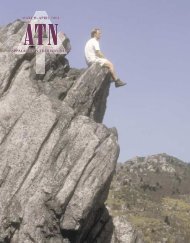
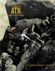
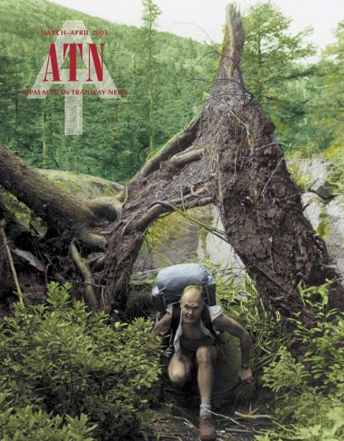
ON THE COVER<br />
The late Dave Richie nearing completion of his<br />
A.T. hike in Maine in 1986. Richie’s life and<br />
contribution to the <strong>Trail</strong> project are remembered<br />
beginning on page 8, below. (Photo: Deborah<br />
Richie) Inside: A red fox along the A.T., near<br />
Spence Field Shelter in the Great Smoky Mountains<br />
National Park. (Photo: Tommy Kirkland)<br />
VIEWPOINTS<br />
SHELTER REGISTER ♦ LETTERS 4<br />
OVERLOOK ♦ BRIAN T. FITZGERALD<br />
AND DAVE STARTZELL 5<br />
REFLECTIONS ♦ COMING HOME 34<br />
WHITE BLAZES<br />
PAPER TRAIL ♦ NEWS FROM<br />
HARPERS FERRY 29<br />
SIDEHILL ♦ NEWS FROM CLUBS<br />
AND GOV ERN MENT AGENCIES 30<br />
TREELINE ♦ NEWS FROM ALONG<br />
THE APPALACHIAN TRAIL 32<br />
GREENWAY ♦ LAND-PROTECTION<br />
AND FUND-RAISING NEWS 33<br />
BLUE BLAZES<br />
THE LONG JOURNEY OF DAVE RICHIE,<br />
1932–2002 ♦ DAVE STARTZELL 8<br />
A.T. CONFERENCE PROGRAM:<br />
WATERVILLE VALLEY 2003 13<br />
TREADWAY<br />
MEMORIAL GIFTS 12<br />
HONORARY GIFTS 12<br />
NOTABLE GIFTS 29<br />
PUBLIC NOTICES 38<br />
APPALACHIAN TRAILWAY NEWS 3
SHELTER REGISTER<br />
Letters from our readers<br />
<strong>Appalachian</strong> <strong>Trail</strong>way<br />
News<br />
VOLUME 64, NUMBER 1 • MARCH–APRIL 2003<br />
<strong>Appalachian</strong> <strong>Trail</strong>way News is published by the Ap pa la chian<br />
<strong>Trail</strong> Conference, a non profit educational organization rep re sent ing<br />
the citizen interest in the <strong>Appalachian</strong> <strong>Trail</strong> and ded i cat ed to the<br />
pres er va tion, main te nance, and enjoyment of the Ap pa la chian <strong>Trail</strong>way.<br />
Since 1925, the <strong>Appalachian</strong> <strong>Trail</strong> Con fer ence and its member<br />
clubs have con ceived, built, and maintained the Ap pa la chian <strong>Trail</strong><br />
in cooperation with federal and state agencies. The Conference also<br />
pub lish es guidebooks and other educational lit er a ture about the<br />
<strong>Trail</strong>, the trailway, and its facilities. Annual in di vid u al mem ber ship<br />
in the Ap pa la chian <strong>Trail</strong> Conference is $30; life membership, $600;<br />
corporate membership, $500 minimum annual con tri bu tion.<br />
Volunteer and freelance con tri bu tions are welcome. Please in clude<br />
a stamped, self-addressed en ve lope with your submission.<br />
Observations, conclusions, opin ions, and product endorsements<br />
expressed in <strong>Appalachian</strong> <strong>Trail</strong>way News are those of the authors<br />
and do not nec es sar i ly reflect those of mem bers of the board or staff<br />
of the <strong>Appalachian</strong> <strong>Trail</strong> Con fer ence.<br />
DIRECTOR OF PUB LIC AFFAIRS<br />
Brian B. King<br />
EDITOR<br />
Robert A. Rubin<br />
BOARD OF MANAGERS<br />
Chair<br />
Brian T. Fitzgerald<br />
Vice Chairs<br />
Carl C. Demrow Thyra C. Sperry<br />
Marianne J. Skeen<br />
Treasurer<br />
Kennard R. Honick<br />
Secretary<br />
Parthena M. Martin<br />
Assistant Secretary<br />
Arthur P. Foley<br />
New England Region<br />
Pamela Ahlen Stephen L. Crowe<br />
Thomas O. Lewis Andrew L. Petersen<br />
Dennis Regan Ann H. Sherwood<br />
Mid-Atlantic Region<br />
Walter E. Daniels Charles A. Graf<br />
Sandra Marra Eric C. Olson<br />
Glenn Scherer William Steinmetz<br />
Southern Region<br />
Bob Almand Phyllis Henry<br />
Robert P. Kyle<br />
William S. Rogers James M. Whitney, Jr.<br />
Steven A. Wilson<br />
Members at Large<br />
Paul Burkholder Al Sochard<br />
EXECUTIVE DIRECTOR<br />
David N. Startzell<br />
World Wide Web: <br />
<strong>Appalachian</strong> <strong>Trail</strong>way News (ISSN 0003-6641) is published<br />
bimonthly, except for January/Feb ru ary, for $15<br />
a year by the <strong>Appalachian</strong> <strong>Trail</strong> Con fer ence, 799 Washing<br />
ton Street, Harp ers Ferry, WV 25425, (304) 535-6331.<br />
Bulk-rate postage paid at Harpers Ferry, WV, and other<br />
offices. Post mas ter: Send change-of-address Form 3597<br />
to <strong>Appalachian</strong> <strong>Trail</strong>way News, P.O. Box 807, Harpers<br />
Ferry, WV 25425.<br />
Copyright © 2003, The Ap pa la chian <strong>Trail</strong> Conference.<br />
All rights re served.<br />
Fuel cells vs. windmills<br />
Andrew Priestley’s letter regarding the<br />
proposed Maine wind farm, in the November–December<br />
ATN, presents some<br />
significant misinformation. He suggests<br />
that fuel cells burning hydrogen and producing<br />
only water vapor represent renewable<br />
energy's future—leapfrogging wind<br />
power (a “dead-end technology”). But, just<br />
where will that hydrogen come from?<br />
Today’s fuel cells use natural gas or<br />
gasoline to produce the hydrogen. Those<br />
fossil fuels are first processed in a “reformer”<br />
to separate out the hydrogen<br />
(releasing carbon dioxide in the process).<br />
Many proponents of renewable energy and<br />
fuel cells, myself included, look to wind<br />
farms as one of the best ways to generate<br />
hydrogen from renewable energy.<br />
Here’s how it would work: During<br />
peak electric-demand periods, when electricity<br />
is needed, wind farms would send<br />
their power directly into the electricity<br />
grid. During nonpeak hours, typically at<br />
night, excess wind-generated electricity<br />
would be used to produce hydrogen from<br />
water through the process of “electrolysis.”<br />
The hydrogen thus produced could<br />
be stored, transported, and then used, as<br />
needed, to power the fuel cells.<br />
I continue to be saddened by the <strong>Appalachian</strong><br />
<strong>Trail</strong> Conference’s position on<br />
the Maine wind farm. If we—as people<br />
who celebrate and cherish the outdoors—<br />
cannot recognize that renewable energy<br />
sources provide our only real means of<br />
ensuring that this beauty will be around<br />
for our grandchildren and greatgrandchildren<br />
to enjoy, then how can we expect the<br />
general public to buy into the idea of protecting<br />
wild areas, such as the A.T. corridor<br />
and its viewscape? Global warming<br />
now threatens the very forests that make<br />
New England such a wonderful place.<br />
Without a shift to renewable energy<br />
sources, my own state of Vermont is projected<br />
to lose its maple forests—perhaps<br />
within the next century. I’d rather retain<br />
those maple forests with a few windmills<br />
on the ridges and be able to see those<br />
windmills through clear blue skies than<br />
have to peer through hazy gray skies at<br />
ridges whose native vegetation has been<br />
replaced by more southern species.<br />
Alex Wilson Dummerston<br />
Vermont Editor, Environmental<br />
Building News<br />
!<br />
Mr. Priestly suffers from a common<br />
misconception: that fuel cells somehow<br />
change our fundamental energy<br />
outlook. Because this particular myth is<br />
being promoted heavily by people in<br />
government and industry with a stake in<br />
the energy status quo, I’m appalled to see<br />
it repeated as fact in the ATN.<br />
Fuel cells, simply put, are only another<br />
way of burning a fuel. Essentially<br />
all the fuel cells in the world today use<br />
fossil fuel (or other fuels produced using<br />
fossil or nuclear energy).<br />
The “hydrogen economy” that a lot of<br />
people are counting on is just another way<br />
of moving energy to its point of consumption.<br />
Burning hydrogen is cleaner at the<br />
point of use, but you still need a fossil,<br />
nuclear, or renewable energy source to<br />
make it. Much of the original is energy<br />
lost to inefficiencies in producing, storing,<br />
and transporting the hydrogen.<br />
Running a fuel cell on alcohol from<br />
biomass comes closer to the mark, but<br />
our current farming methods require so<br />
much energy input (fuel, fertilizer, transportation,<br />
etc.) that you’re lucky if the<br />
Letters<br />
<strong>Appalachian</strong> <strong>Trail</strong>way News<br />
welcomes your comments. Letters<br />
will be edited for clarity and length.<br />
Please send them to:<br />
Letters to the Editor<br />
<strong>Appalachian</strong> <strong>Trail</strong>way News<br />
P.O. Box 807<br />
Harpers Ferry, WV 25425-0807<br />
E-Mail: <br />
4<br />
MARCH–APRIL 2003
Overlook<br />
Brian T. Fitzgerald and Dave Startzell<br />
alcohol coming out represents as much<br />
energy as you put into growing the corn.<br />
Elsewhere, forested areas have been clearcut<br />
and replanted with fast-growing species<br />
to be mass-harvested for fuelwood<br />
every few years; I don’t know if this<br />
scheme’s energy economics work better,<br />
but it doesn’t sound like Mr. Priestly<br />
would like that in Maine, either.<br />
America has a choice: If we continue<br />
on our fossil-fueled spree, regardless of the<br />
consequences of global warming, we will<br />
still hit the wall when supplies are exhausted.<br />
I believe we should follow the<br />
example of the Europeans and put our efforts<br />
into renewables and conservation in<br />
order to build something that will last.<br />
James Van Bokkelen<br />
South Hampton, New Hampshire<br />
!<br />
The letter by Tom Thwaites (who has<br />
had an immense impact on central<br />
Pennsylvania’s hiking, and that is an<br />
understatement) in the September 2002<br />
ATN makes a good point—windmills are<br />
beautiful, too, in their own way.<br />
Nature is beautiful, but the creations<br />
of man can, likewise, be beautiful. One<br />
need only read the works of Walt Whitman<br />
to know that this is not a new idea.<br />
There are thousands upon thousands of<br />
miles of trails with nice scenery and<br />
natural settings, but where else can you<br />
catch a breathtaking view of such an awesome<br />
creation as gigantic windmills?<br />
Frankly, the vistas of forested mountains<br />
are all starting to look the same to me,<br />
and I would delight in seeing something<br />
new and wonderful.<br />
I, for one, will continue to appreciate<br />
trails as they are and as they change. If I<br />
want to see unspoiled valleys, there are<br />
plenty of them in my backyard, but, if the<br />
wind farm becomes a reality, I just might<br />
make the trip to see it. It would truly be<br />
a sight to behold.<br />
William Ames<br />
State College, Pennsylvania<br />
Meeting our responsibilities as caretakers<br />
and stewards of the <strong>Appalachian</strong><br />
<strong>Trail</strong> sometimes threatens issue our effort this year to get a<br />
NOTE—We mentioned in the last<br />
to overwhelm us, so we try to stay better handle—at ATC and at the<br />
focused on those issues that directly<br />
affect the footpath. But, sometimes Park Service partner—on setting<br />
office of our principal National<br />
public-policy issues that may not, at first, priorities for the many elements<br />
seem related to the <strong>Trail</strong> can have serious of our basic work of taking care<br />
implications for our work on the A.T. We of the <strong>Trail</strong>. If you would like to<br />
thought we’d take the opportunity here to join directly in that discussion<br />
highlight some recent examples.<br />
(after all, it’s your dues at work!),<br />
NEW SOURCE REVIEW—In late November we would definitely like to see<br />
2002, the Environmental Protection Agency your answers to the set of questions<br />
on page 7.<br />
(EPA) relaxed certain regulations for enforcing<br />
the Clean Air Act that Congress passed<br />
in 1977. Those regulations required the power plants that were operating when the<br />
law was passed—plants that produce “dirtier” power than more modern plants—to<br />
meet stricter pollution-control standards if they were rebuilt. Congress assumed<br />
that those plants would either be decommissioned or upgraded to meet modern<br />
air-pollution standards. However, after twenty-five<br />
years, many of those plants remained in operation and<br />
New sources<br />
of concern<br />
continued to emit pollutants that cause acid rain and<br />
smog along the <strong>Appalachian</strong> <strong>Trail</strong>.<br />
One reason that they’re still running is an exception<br />
to the regulations that allowed utilities to perform<br />
“routine maintenance” at older power plants without meeting the new standards.<br />
Under that exception, many of the plants were upgraded to extend their service<br />
lives without having to be reviewed as a “new source” of pollution. That practice<br />
led the federal government and eight states to sue the owners of many of the plants<br />
to enforce the “New Source Review” provisions of the law. EPA’s recent decision<br />
leaves those lawsuits in limbo and greatly expands the exemption, which allows<br />
a plant owner to essentially rebuild old plants without installing new pollutioncontrol<br />
equipment. Nine states, almost all of which contain parts of the A.T., have<br />
sued EPA over that decision. A bipartisan group in Congress (mostly senators) so<br />
far has had little success in blocking it legislatively.<br />
OFF-ROAD-VEHICLE EMISSIONS—In another action related to air pollution, EPA<br />
last fall proposed regulations that would regulate emissions from off-road engines,<br />
including those on snowmobiles and all-terrain vehicles. In areas where riding<br />
snowmobiles and all-terrain vehicles is a popular pastime, those vehicles can be<br />
a major source of harmful pollutants. According to EPA, a two-cycle snowmobile<br />
ridden for one hour emits as much pollution as nearly one hundred low-emission<br />
automobiles driven for the same amount of time. Since those engines have been<br />
unregulated until now, the proposed regulations should be good news. But, the<br />
proposals are rather weak. Technology already exists that would greatly reduce<br />
air pollution from those engines at a reasonable cost. But, unfortunately, EPA has<br />
not required more significant reductions. That action will not only affect air quality<br />
generally, but will result in higher local pollutant levels in areas near the A.T.<br />
where snowmobiling is popular.<br />
continued on next page<br />
APPALACHIAN TRAILWAY NEWS 5
Shelter Register<br />
Lexus owners welcome<br />
In Lee Solomon’s letter, “Life Goals”<br />
(November–December 2002), he says,<br />
“Not many Lexus drivers would have<br />
much interest at all in hiking the <strong>Appalachian</strong><br />
<strong>Trail</strong>.” I respect anyone who<br />
chooses to be on the <strong>Trail</strong>. As long as<br />
they are not causing harm to the environment<br />
or fellow hikers, it should not matter<br />
what type of car they choose to drive.<br />
During my 2002 thru-hike, I met hikers<br />
from all walks of life.<br />
Marc Virtue (Dirty Bird)<br />
Frederick, Maryland<br />
!<br />
Unlike Lee Solomon, when I saw the<br />
Lexus commercial, I was delighted that<br />
TV people were giving us not merely a<br />
mention, but also endorsing the A.T. as<br />
a life goal. The <strong>Trail</strong> belongs to everyone,<br />
not merely elitists.<br />
As for Lexus drivers, the two I see<br />
regularly would be great to have on the<br />
<strong>Trail</strong>. One of them has, indeed, hiked a<br />
chunk of it. Maybe Mr. Solomon’s letter<br />
was intended to be tongue-in-cheek, but<br />
some of us found it mean-spirited.<br />
James W. Kerr<br />
Easton, Maryland<br />
OVERLOOK<br />
continued from previous page<br />
Hunting safety<br />
I<br />
’ve been hunting for 35 years, and I<br />
would like to encourage the victim [of<br />
the Georgia hunting accident], Rachel<br />
Ferguson, to press charges against the<br />
hunter. The hunter violated a number of<br />
safety and hunting rules. First, he should<br />
have never pulled the trigger unless he<br />
was sure of his target. Also, no one should<br />
ever take a 220-yard shot at a deer with<br />
a .243-caliber rifle except on open ground.<br />
A hunter must be aware of what lies beyond<br />
the target. Obviously, he didn’t<br />
check. And, lastly, a hunter must always<br />
know the terrain and area in which he or<br />
she is hunting. A simple check of a topographical<br />
map would have enlightened<br />
him that the A.T. was in his line of fire.<br />
Ms. Ferguson and her family should<br />
make sure that the hunter charged in the<br />
case is convicted of a felony, so that he<br />
can never legally own a firearm, and<br />
Georgia should revoke his hunting privileges<br />
for life in order to prevent him from<br />
injuring someone with an arrow or a<br />
muzzle-loading firearm.<br />
The A.T. should be a safe place without<br />
hikers wearing blaze orange [during<br />
hunting season], but wearing it is nevertheless<br />
advisable. I have encountered<br />
people riding horses through the woods<br />
WETLAND PROTECTION—Finally, EPA and the U.S. Army Corps of Engineers recently<br />
proposed new regulations that would limit the scope of the Clean Water Act<br />
of 1972 and 1977. Under their proposal, many small streams and wetlands, like<br />
those found all along the A.T., would no longer be protected by federal law. That<br />
would allow such wetlands to be drained and filled, and streams to be “dewatered”<br />
or relocated, without any federal regulatory review. State and local laws would still<br />
apply, but the basic protections provided by the Clean Water Act for the last thirty<br />
years would not.<br />
Although the impact of the new regulations might not be as apparent as a cellphone<br />
tower or powerline crossing, they do affect the <strong>Trail</strong>. We don’t intend to<br />
forget our basic work and divert all of our energy to fighting adverse government<br />
regulations, but we will take the opportunity to keep you informed. In some cases,<br />
we will actively participate in these public-policy debates.<br />
Brian T. Fitzgerald is chair of ATC; Dave Startzell is executive director.<br />
during hunting season; when I confronted<br />
them about the danger, and not showing<br />
any orange, they became defiant. I even<br />
encountered a woman walking through<br />
the woods during bear season in New<br />
York wearing a black fur coat and hat! A<br />
little help from both hikers and hunters<br />
will maintain the safety record of the A.T.<br />
I hope that Ms. Ferguson fully recovers,<br />
and that she and her family are not distracted<br />
by the hunter’s first-aid and hospital<br />
visits. The shooting should never<br />
have happened.<br />
Michael Modrak<br />
Nashville, Tennessee<br />
!<br />
As a lifetime member and trail maintainer<br />
with the Benton MacKaye <strong>Trail</strong><br />
Association, I take hiker and maintainer<br />
safety very seriously. Last year, in preparation<br />
for the Georgia deer-hunting season,<br />
I wrote an article on safety issues for<br />
the association’s newsletter and followed<br />
that up with another article discussing<br />
the tragic shooting of a hiker near the A.T.<br />
here in Georgia.<br />
Hiker-hunter interactions can be divisive<br />
and can create long-standing animosities<br />
between the different groups<br />
that use our public lands and trails. With<br />
this in mind, I was dismayed to read the<br />
conclusion to your article (ATN November–December<br />
2002). The last paragraph<br />
states that, “last year, the Chattahoochee<br />
reported fifty-two cases of hunters shooting<br />
other hunters, ten of them fatally.”<br />
That is incorrect. For the entire state of<br />
Georgia, fifty-one hunters were injured<br />
in hunting-related accidents, nine of<br />
whom died. Of the nine hunters killed<br />
during that deer season, four died in treestand<br />
accidents. The remaining five were<br />
shot by other hunters.<br />
The shooting accident described in<br />
your article is certainly unfortunate, but<br />
it is also very rare for Georgia. With an<br />
issue as potentially explosive as this one,<br />
I think it is in our best interests as a <strong>Trail</strong><br />
community to be sure of our facts and<br />
clear in our discussions.<br />
Bill Ross<br />
Calhoun, Georgia<br />
6<br />
MARCH–APRIL 2003
In a recent <strong>Appalachian</strong> <strong>Trail</strong>way News column,<br />
“Looking to our future,” ATC Chair Brian T. Fitzgerald<br />
and Executive Director Dave Startzell described a planning<br />
process that will help ATC and its partners at the<br />
National Park Service’s <strong>Appalachian</strong> <strong>Trail</strong> Park Office<br />
(ATPO) set priorities for the coming decade and make any<br />
organizational changes needed to achieve a common vision<br />
for the future of the <strong>Trail</strong>. Part of that planning process<br />
involves asking supporters of the <strong>Trail</strong> project for their<br />
ideas, which is the point of the questionnaire below.<br />
ATC and ATPO have retained The Delphi Group, an<br />
organizational consulting firm, to help develop this planning<br />
process. Beginning last August, they have addressed<br />
planning issues at a series of meetings that will culminate<br />
in a “strategic planning summit” in May 2003. The summit<br />
will involve a range of participants, including club<br />
The future: Your thoughts?<br />
ATC/ATPO planning questionnaire<br />
leaders and agency partners. It will work to develop a<br />
common mission and vision for ATC and ATPO and decide<br />
which will take primary responsibility for each of the many<br />
activities of maintaining and managing the A.T.<br />
ATC is particularly interested in responses to the following<br />
questions for the planning process. Although they<br />
cannot respond to individual comments, the planners will<br />
take all of them into consideration and keep you informed<br />
of the plan’s progress in future editions of ATN.<br />
Please visit the ATC Web site, , for more information on this process and<br />
an electronic form for your comments, or mail this questionnaire<br />
to: <strong>Appalachian</strong> <strong>Trail</strong> Conference, P.O. Box 807,<br />
Dept. OA, Harpers Ferry, WV 25425. Please feel free to<br />
attach a separate sheet of paper for additional comments.<br />
❶ Of the following, which do you value most<br />
about the <strong>Appalachian</strong> <strong>Trail</strong>? Please rank from<br />
1 (most important) to 6 (least important).<br />
❷ How well does ATC/ATPO protect and promote<br />
those values? Please grade them. (A=excellent,<br />
B=good, C=fair, D=poor, F=not at all)<br />
Opportunities for hiking and camping in the backcountry.<br />
Providing a place and subject for teaching and learning.<br />
Role of volunteers in maintaining and supporting the <strong>Trail</strong>.<br />
A “greenway” of protected lands surrounding the length of the <strong>Trail</strong>.<br />
Preservation of the <strong>Trail</strong>’s natural resources, including native plants and animals,<br />
and water and air quality.<br />
Other:<br />
❸ Many new and challenging issues face the <strong>Trail</strong> today. How would you like to see ATC grow or change to<br />
address these challenges?<br />
❹ ATC undertakes an ever-expanding range of activities. Which do you think should be the highest priority,<br />
and why? Are there any activities you are aware of that ATC should not be involved in?<br />
❺ As an outgrowth of the National <strong>Trail</strong>s System Act and the federal land-acquisition program, the A.T. is<br />
a unit of the national park system. Do you consider the close partnerships of ATC with the National Park<br />
Service and the U.S. Forest Service beneficial to the <strong>Trail</strong> and the organizations? Why? If not, why not?<br />
❻ Do you have additional ideas that might help this process? Please be specific.<br />
APPALACHIAN TRAILWAY NEWS 7
The long journey of Dave Richie, 1932–2002<br />
By Dave Startzell<br />
When we asked one of the Conference’s<br />
newest staff members recently to<br />
search the files for photographs of<br />
Dave Richie, most of them more than fifteen<br />
years old, she immediately knew who we<br />
meant. “Sure,” she said. “He’s the one who<br />
was always smiling.”<br />
Richie, the first manager of what is now the <strong>Appalachian</strong><br />
<strong>Trail</strong> Park Office (ATPO) of the National Park Service, was not<br />
one who sought or easily accepted credit for successes, although<br />
he might have accepted that compliment. Ordinarily, however,<br />
he disappeared from the limelight at ceremonies quicker than<br />
one could say “VIP.” At the time of his death at his home in<br />
Hampstead, North Carolina, five days before Christmas 2002,<br />
few of today’s A.T. hikers could have told you who Dave<br />
Richie was.<br />
The fact remains, however, that he had more to do with<br />
the reality of today’s <strong>Appalachian</strong> National Scenic <strong>Trail</strong> and<br />
its management than any other single person. David A.<br />
Richie belongs with Benton MacKaye and Myron Avery in<br />
the “pantheon” of the <strong>Appalachian</strong> <strong>Trail</strong> project.<br />
His was a long journey, although it seemed both short and<br />
linear. To date, none of the histories of the <strong>Trail</strong> project have<br />
acknowledged Richie’s place in the pantheon. It is time that<br />
they did so. His professional legacy during his quartercentury<br />
with the National Park Service defies measurement,<br />
and it has been inherited by a succession of ATPO managers<br />
who have shared and applied many of his convictions.<br />
First steps<br />
Richie was born in 1932 in Moorestown, New Jersey. He<br />
attended Westtown School, where he served as student body<br />
president, and then Haverford College. At both Westtown<br />
and Haverford, in addition to his strong academic and<br />
leadership skills, he demonstrated his natural athletic<br />
abilities as a soccer and baseball player. During several<br />
summer breaks, he and his life-long friend, Earl Harrison,<br />
worked in Alaska, which no doubt contributed to his<br />
appreciation for the natural world.<br />
In the early 1950s, he took a leave of absence from<br />
Haverford and enlisted in the Navy as a jet-pilot cadet,<br />
earning his wings while stationed in Pensacola, Florida. He<br />
then entered the Marine Corps, stationed at Cherry Point,<br />
North Carolina, where he first met his future wife. He retired<br />
from the Marine Corps Reserve with the rank of captain.<br />
He returned to Haverford, completing his undergraduate<br />
degree in political science in 1958, then went to work in the<br />
public-affairs section of the Bureau of Land Management.<br />
While there, he entered the night-school program at George<br />
Washington University Law School and earned his law<br />
degree. Then, he transferred from BLM to the National Park<br />
Service, serving for a year as an American Political Science<br />
Association fellow detailed to the office of Senator Charles<br />
McC. Mathias of Maryland (who later would become one of<br />
the prime sponsors for the National <strong>Trail</strong>s System Act).<br />
Richie’s first field assignment for the Park Service was as<br />
assistant superintendent at Mount Rainer National Park,<br />
from 1966 to 1967. He then became superintendent at Lake<br />
Roosevelt National Recreation Area/Grand Coulee Dam<br />
from 1967 to 1969.<br />
In 1969, he left the Park Service to teach history for two<br />
years at his alma mater, Westtown School. In 1971, he<br />
returned to become superintendent of the George Washington<br />
Memorial Parkway, where he contributed to the success<br />
of a number of features in that linear park along the Potomac<br />
River and Washington’s boundaries, including the conversion<br />
to public use of Turkey Run Farm and an abandoned amuse-<br />
8<br />
MARCH–APRIL 2003
ment park at Glen Echo. He also initiated the construction of<br />
a now-popular hiker/biker trail to Mount Vernon, drawing<br />
heavily on volunteers in the project.<br />
A new direction: Maine to Georgia<br />
With passage of the 1968 National <strong>Trail</strong>s System Act,<br />
Congress designated the <strong>Appalachian</strong> <strong>Trail</strong> as one of the<br />
nation’s first national scenic trails and assigned primary overall<br />
administrative responsibility to the Department of the<br />
Interior and its National Park Service. But, that federal<br />
agency had little or no experience managing long-distance<br />
trails and, in fact, had done little to implement the act. In<br />
1974, Richie accepted a new assignment as deputy director<br />
for the Northeast Regional Office of the National Park<br />
Service in Boston. When he took his new job, he sought—and<br />
was assigned—responsibility for the <strong>Appalachian</strong> National<br />
Scenic <strong>Trail</strong>.<br />
To further complicate matters, the <strong>Trail</strong> was a patchwork<br />
quilt of administrative jurisdictions, including six national<br />
parks, eight national forests, and dozens of state-administered<br />
parks, forests, and game-management units. In addition,<br />
600 miles of the <strong>Trail</strong> were situated on privately owned<br />
lands, while another 200 miles were located along roads.<br />
The legislation had authorized state and federal landacquisition<br />
programs to establish a permanent right-ofway<br />
and buffer zone for the <strong>Trail</strong>, but few funds were<br />
actually appropriated. Knowing little or nothing about<br />
long-distance trails, and with scarcely any funds to draw<br />
upon, the National Park Service assigned the task of defining<br />
an appropriate oversight role for the <strong>Trail</strong> project to<br />
Richie. Perhaps unknowingly, exactly the right man had<br />
sought the job.<br />
While many in his position might have been daunted by<br />
the sheer magnitude of the <strong>Trail</strong> project, Richie, a longdistance<br />
runner who twice ran the Boston Marathon while<br />
stationed in Boston and who had a strong affinity for outdoor<br />
recreation as well as a passion for natural-resource conservation,<br />
almost immediately saw the great potential of<br />
the <strong>Trail</strong> project. He was stimulated by the notion—<br />
well established through five decades of work by the<br />
<strong>Appalachian</strong> <strong>Trail</strong> Conference and its <strong>Trail</strong>-maintaining<br />
clubs—that citizen volunteers could play a<br />
significant role in creating and caring for a natural<br />
and recreational resource spanning more than 2,000<br />
miles.<br />
He soon became so consumed in the project<br />
that he fought for the creation of a separate<br />
National Park Service office dedicated solely<br />
to administration of the <strong>Trail</strong>. Once that was<br />
accomplished, he volunteered to serve as<br />
its first manager—a position he assumed<br />
in 1977. He successfully argued that, because the <strong>Trail</strong><br />
crossed multiple jurisdictions as well as four National Park<br />
Service regions, the office should be centrally located and its<br />
manager should report to the Park Service associate director<br />
for operations in Washington, rather than through a regional<br />
director as a traditional park superintendent would.<br />
In 1978, the <strong>Appalachian</strong> <strong>Trail</strong> Project Office moved to<br />
Harpers Ferry, just two blocks from the headquarters of the<br />
<strong>Appalachian</strong> <strong>Trail</strong> Conference. In fact, for the first few<br />
months until separate office space could be found, Richie and<br />
his assistant, Steve Golden, set up shop in a corner office on<br />
the second floor of the ATC headquarters building.<br />
As one of his first forays into the <strong>Trail</strong> project, while still<br />
stationed in Boston, Richie attended the biennial ATC<br />
membership conference in Boone, North Carolina, in 1975. It<br />
was at that conference that then-ATC Board of Managers<br />
member Ed Garvey introduced a resolution forcefully chastising<br />
the National Park Service for failing to do more to stem<br />
the tide of second-home development and other forces that<br />
were eroding the primitive character of the <strong>Trail</strong> and threatening<br />
to sever it altogether in many places.<br />
That experience deeply affected Richie. A year or so later,<br />
when a Washington outsider, Jimmy<br />
Carter, entered the White House,<br />
Richie, along with leaders of<br />
ATC, several of the <strong>Trail</strong>maintaining<br />
clubs, and members<br />
of the <strong>Appalachian</strong> National<br />
Scenic <strong>Trail</strong> Advisory Council<br />
(ANSTAC), wasted little time<br />
in cultivating relationships with<br />
9
key members of the new administration, including the new<br />
assistant secretary for fish, wildlife and parks, Robert Herbst.<br />
Herbst adopted as a first-term goal of the administration the<br />
completion of an <strong>Appalachian</strong> <strong>Trail</strong> land-acquisition program.<br />
In 1977, legislation was introduced in the form of<br />
amendments to the National <strong>Trail</strong>s System Act that greatly<br />
expanded federal land-acquisition authority for the <strong>Trail</strong> and<br />
also included a funding authorization of $90 million. In<br />
March 1978, the amendments—known as the “<strong>Appalachian</strong><br />
<strong>Trail</strong> Bill”—were signed into law.<br />
At the time, the National Park Service maintained a<br />
professional land-acquisition staff, but the typical Park<br />
Service approach was to operate such programs from one of<br />
its regional offices. Richie again successfully argued for a<br />
different approach: a dedicated, centralized field office. While<br />
land-acquisition responsibilities for the <strong>Trail</strong> project initially<br />
were based in the Park Service’s mid-Atlantic regional office<br />
in Philadelphia under the capable leadership of perhaps the<br />
most experienced specialist in the agency, Charles (“Chuck”)<br />
Rinaldi, within a year the <strong>Appalachian</strong> <strong>Trail</strong> Land Acquisition<br />
Field Office was established in Martinsburg, West<br />
Virginia, only a short distance from the ATPO and ATC<br />
offices in Harpers Ferry.<br />
That was not the only change Richie introduced to the<br />
standard operating procedures of the National Park Service.<br />
An ardent believer in volunteer leadership, Richie also<br />
wanted volunteers from the <strong>Trail</strong>-maintaining clubs, as well<br />
as the staff of the <strong>Appalachian</strong> <strong>Trail</strong> Conference, to play key<br />
roles in determining the direction of the land-acquisition<br />
project for the <strong>Trail</strong>. Those roles included scouting new<br />
routes, identifying corridor boundaries, participating in<br />
public hearings, and even engaging in title research and<br />
initial contacts with affected landowners. He, along with<br />
leaders and staff members of ATC, also argued that the<br />
government could reduce the opposition of landowners along<br />
the proposed corridor by not buying all the land outright.<br />
Instead, the government could purchase or acquire easements—deeds<br />
that guaranteed protection of the property and<br />
a right-of-way for the <strong>Trail</strong>, while still leaving the land in<br />
private ownership. That approach also was atypical for the<br />
Park Service. Eventually, Rinaldi and others on his staff came<br />
to value the contributions of volunteers in many facets of the<br />
land-acquisition process and to apply a full range of landacquisition<br />
“tools,” including both right-of-way and scenic<br />
easements, term estates, and land exchanges, in addition to<br />
the acquisition of fee-simple interests.<br />
The antibureaucrat<br />
I<br />
first met Dave Richie in 1975, at a trails conference held<br />
at the Tennessee Valley Authority facilities at Land between<br />
the Lakes. I had just completed my graduate studies<br />
in urban and regional planning at the University of<br />
Tennessee, and I was struggling to complete my thesis, which<br />
dealt with various aspects of outdoor-recreation planning,<br />
including trail-system planning. Dave only recently had been<br />
assigned responsibilities for the <strong>Appalachian</strong> National Scenic<br />
<strong>Trail</strong>, but he already was speaking of the project with great<br />
enthusiasm.<br />
What struck me most about him was his demeanor. He<br />
was a deputy regional director in the National Park Service—a<br />
position that sounded, at least, as if it carried considerable<br />
responsibilities and authority. But, Dave had none<br />
of the trappings one might associate with a person in such<br />
a position. There was no aloofness, no hint of inflated selfimportance,<br />
no protocol-conscious authoritarianism. He was<br />
not the stereotypical bureaucrat. In fact, he struck me more<br />
as an “antibureaucrat.”<br />
He was a regular guy, as they say, and one clearly on a<br />
mission: He wanted to reinvigorate the then fifty-year-old<br />
<strong>Appalachian</strong> <strong>Trail</strong> project; he wanted to assure the continuity<br />
and quality of the <strong>Trail</strong>; and he wanted to instill in his<br />
professional counterparts from the various federal and state<br />
agencies represented at that meeting an appreciation for the<br />
great potential of partnerships and volunteer-based citizen<br />
Dave Richie<br />
action. At that time, he was not preaching to the choir.<br />
I had an opportunity to meet Dave on several more occasions<br />
during the next couple of years, usually at A.T.-related<br />
meetings in the Great Smoky Mountains National Park or<br />
in one of the nearby national forests in Tennessee or North<br />
Carolina. Then, in mid-January 1978, I reported for work at<br />
the ATC headquarters building in Harpers Ferry as director<br />
of education.<br />
10<br />
MARCH–APRIL 2003
In the initial years of the land-acquisition program, a<br />
number of controversies and organized opposition surfaced—in<br />
the Cumberland Valley area of Pennsylvania, in<br />
Phillipstown, New York, in Falls Village and Salisbury,<br />
Connecticut, in Sheffield and Tyringham, Massachusetts,<br />
at Killington and Pico near Rutland, Vermont, and at<br />
Saddleback Mountain in Maine. In some cases, resolution<br />
of those conflicts was not fully achieved until well after<br />
Richie retired in 1987. But, in most of those situations,<br />
Richie set the tone for the often difficult and protracted<br />
negotiations. His approach to such controversies was<br />
similar to his approach to human relationships in general:<br />
He shunned authoritarianism, greeted adversaries with<br />
respect, and consistently struggled to achieve a negotiated<br />
settlement, but rarely, if ever, compromised important<br />
<strong>Trail</strong> values. His style and his influence in shaping the<br />
form and substance of the land-acquisition program during<br />
the initial years of that now 25-year-old program is wellevidenced<br />
today: The National Park Service has very<br />
nearly completed its A.T. program—perhaps the most<br />
complex and successful land-acquisition program in the<br />
history of that agency.<br />
Working toward partnership<br />
Success in the A.T. land-acquisition program is only one<br />
aspect of Richie’s contributions to the <strong>Appalachian</strong> <strong>Trail</strong> project,<br />
however. Indeed, many who knew and worked with him<br />
might argue that his most significant contribution to the<br />
project was in promoting public/private partnerships and in<br />
forging working relationships across many jurisdictions in<br />
what he called the “cooperative management system.”<br />
For example, recognizing that more than half of the <strong>Trail</strong><br />
was situated within the national forests, Richie argued for a<br />
Forest Service liaison position in his office—a Forest Service<br />
employee to work under the Park Service umbrella. That<br />
position, created in 1979, continues to this day. Its first<br />
occupant was Larry Henson, a rising star in the Forest<br />
Service and one of the youngest persons to serve as a USFS<br />
forest supervisor. Hensen later went on to become a regional<br />
forester and associate deputy chief for the agency. Together,<br />
Richie and Henson successfully encouraged the Forest<br />
Service to become more receptive to working cooperatively<br />
with volunteers and to devote greater attention to trails and<br />
other recreational resources in the eastern forests in general.<br />
Richie also promoted volunteerism and working partner-<br />
Not long after that, Dave and his assistant, Steve<br />
Golden, relocated to Harpers Ferry to establish a new <strong>Appalachian</strong><br />
<strong>Trail</strong> Project Office. For several months, Dave<br />
and Steve set up shop in the ATC headquarters building,<br />
just around the corner from my desk. During that time,<br />
we had many opportunities to discuss and debate the future<br />
direction of the project and the many challenges we faced.<br />
And, debate we did.<br />
As I learned more about the project, and especially about<br />
the relationships—or lack of them—that existed among the<br />
Conference, the <strong>Trail</strong>-maintaining clubs, and the many federal<br />
and state offices involved in the project, I was taken aback<br />
by the lack of “infrastructure” that existed at ATC and by its<br />
tenuous relationships with its ostensible partners in <strong>Trail</strong><br />
work. I had been told that ATC was expected to be the lead<br />
organization in fostering the stewardship of the <strong>Trail</strong>—indeed,<br />
leaders in the Conference had assured Congress in recent<br />
oversight hearings that ATC would do just that. I was full of<br />
the optimism that only youth can explain, and I had served,<br />
at least sporadically, as a <strong>Trail</strong>-maintenance volunteer with<br />
the Smoky Mountains Hiking Club during my graduateschool<br />
years. So, I had some appreciation for the level of<br />
devotion of which volunteers were capable. But, what faith<br />
I had might well have proved insufficient to bridge the chasm<br />
between the realities of that time and the vision recently set<br />
forth by the Conference’s Board of Managers.<br />
While I understood the “power of positive thinking” on<br />
some level, the sort of leap required in the <strong>Trail</strong> project<br />
seemed improbable. But, there was Dave Richie—the consummate<br />
optimist who, at every opportunity, would promote<br />
concepts such as partnership and cooperative management,<br />
and who spoke so eloquently about the great potential present,<br />
but unrealized, in the <strong>Trail</strong> project. He helped me and<br />
many others to look beyond the thick haze of the challenges<br />
of the moment toward the bright light of the possible and to<br />
have the courage and faith to embrace a bold vision. His<br />
enthusiasm was infectious, and, although I encountered any<br />
number of low spots during the next several years, it was not<br />
long before I became a “true believer.”<br />
Dave and I had many occasions to work and travel together<br />
during our overlapping service in the <strong>Trail</strong> project.<br />
Even after he left the area and relocated to North Carolina,<br />
we maintained contact. Dave and Cate often would join us<br />
for walks and talks along the beach whenever we visited our<br />
favorite barrier island, just north of where they lived. Dave<br />
would use our visits to catch up about goings-on in the <strong>Trail</strong><br />
project. But, our conversations often would range farther<br />
afield, into subjects such as land use, the environment, and<br />
world events.<br />
I had known for some time about Dave’s illness. He and<br />
Cate both had spoken openly about it. They understood the<br />
prognosis was not good, but they kept active and upbeat, and,<br />
near the end, squeezed in a last trip to the Yucatan, as well<br />
as visits with their children and grandchildren, and even an<br />
occasional game of golf. And, Dave maintained his involvement<br />
in local conservation issues.<br />
In other words, the last few months of his life probably<br />
were much like all the months before—full of optimism,<br />
humility, and grace.<br />
—Dave Startzell<br />
APPALACHIAN TRAILWAY NEWS 11
ships at the state level, particularly through his interactions<br />
with the <strong>Appalachian</strong> National Scenic <strong>Trail</strong> Advisory<br />
Council—a body established by the Congress through the<br />
National <strong>Trail</strong>s System Act that included representation<br />
from each of the fourteen <strong>Trail</strong> states. Shortly before the end<br />
of its second and final ten-year term in<br />
1988, Richie helped orchestrate the<br />
adoption by the advisory group of a set<br />
of cooperative principles that later<br />
would serve as the basis for many<br />
memoranda of understanding among<br />
various agencies within each state, the<br />
National Park Service, ATC, and the<br />
<strong>Trail</strong>-maintaining clubs. They continue<br />
to influence those relationships<br />
today.<br />
Richie liked principles—broad,<br />
almost poetic doctrines of conduct and<br />
perspective—as opposed to detailed<br />
prescriptions. Perhaps that was an<br />
outgrowth of his fundamental belief in humanity and his<br />
belief that motivation and creativity thrive best in an<br />
unfettered environment. He was not a micromanager.<br />
In 1981, for example, he once again pursued a “less<br />
traveled path” in terms of typical Park Service procedures.<br />
The trails legislation had mandated that the secretary of the<br />
interior, through the National Park Service, develop a<br />
DOC member David Hooke, Richie, ATC Chair<br />
Ruth Blackburn, and Vermont Gov. Hugh Gallen<br />
open new <strong>Trail</strong> section in 1986.<br />
Memorial gifts<br />
comprehensive plan for the <strong>Trail</strong>. Rather than drawing up a<br />
detailed park-management plan, which was the norm within<br />
the agency, Richie argued that, given the multiple jurisdictions<br />
involved in the <strong>Trail</strong> project and the tradition of<br />
private-sector and volunteer stewardship, it would be<br />
presumptuous for the Park Service<br />
alone to develop such a plan for the<br />
A.T. Instead, his office developed a<br />
comprehensive plan that was only 30<br />
pages in length (not including appendices)<br />
and consisted mostly of vision<br />
statements and broad principles<br />
intended to guide management<br />
decisions affecting the <strong>Trail</strong>. The<br />
comprehensive plan was predicated on<br />
an even more unusual concept: that<br />
each of the thirty-one <strong>Trail</strong>-maintaining<br />
clubs would develop its own, more<br />
detailed local-management plan for its<br />
particular sections of the A.T. The<br />
notion that private organizations, consisting mostly of<br />
volunteers, were capable of developing management plans<br />
that would guide not only their own actions, but also those<br />
of federal and state agency partners on public lands, was truly<br />
radical at the time and perhaps even now. But, it was typical<br />
Richie. And, it worked.<br />
continued on page 35<br />
Since our last edition, donations to the <strong>Appalachian</strong> <strong>Trail</strong><br />
Conference were made in memory of:<br />
HAROLD D. ALMOND ⎯ Beth Almond<br />
STEVE BARBER ⎯ Karen Barber, Donald Barber<br />
S. E. BELL, SR. ⎯ Virginia Bell<br />
HARRY BINFORD ⎯ Gregory and Jody Markel<br />
PETER J. BUSHER ⎯ Rand Frahm, B. Terry Johnson, Kimberly and<br />
Kathy Little, William and Tamera McBride, Jason and Susan<br />
Mickel, Trisha D. Neasman, Richard and Christne Owen,<br />
Mikel Renner, Douglas and Marcie Schubert, Jay W. Yingling<br />
CHRIS DEFFLER ⎯ Mr.and Mrs. Edwin and Margaret Deffler,<br />
Mr. and Mrs. John A. Wolff<br />
ROGER DIXON ⎯ Charles and Jill Dixon<br />
CHARLES ERNST FAY ⎯ Jack Fay Robinson<br />
ARTHUR FIORELLI ⎯ Michael and Candace Spigelman<br />
JOE GROSSMAN ⎯ Claudia Bokinsky<br />
LEWIS A. HUNT ⎯ Vernon B. Hunt<br />
JAMES B. (JIM) JOHNSON ⎯ Dorothy Brauer, Richard and Marion<br />
Clark, Joan C. Frank, Peter and Dorothy Hasse, William and<br />
Kathleen Lynch, Mary Rosenberg Interiors, Joyce S. Mc-<br />
Cracken, Kristina A. Schaefer, Peter and Suzanne Thompson,<br />
Toni M. Warbyla<br />
JEROME H. LOWENGARD ⎯ John and Phyllis Graham<br />
BILL MEDLIN ⎯ Parthena M. Martin<br />
DOROTHY STANLEY MOORE ⎯ David L. Brackey, Family Service<br />
& Guidance Center Of Topeka, Inc., Melanie R. Johnston<br />
MRS. FUSAYE NAGASAKI ⎯ Hideko Inouye and W. Ken Graves,<br />
H. Jeannette Pollard<br />
ALVINO OBERLANDER ⎯ Duane and Beverly Mattheis<br />
HARRIET K. PIERCE — As It Is, Inc., Counterpoint Systems, Inc.,<br />
Sharon E. Cowan, Roberta Merchant<br />
MARION AND DAVID C. PINKERTON ⎯ Laura Bliss<br />
D AVE RICHIE ⎯ Goodloe E. Byron, William and Kimiyo<br />
Hutchinson<br />
JOHN W. SCHNEIDER ⎯ Nancy Durrett, Fannie Mullins, John<br />
Rhodes, Don and Barbara Strotman<br />
EARL V. SHAFFER ⎯ Danny W. George, Warren F. Kitzmiller,<br />
William P. McNutt, Jr.<br />
JOHN SHANNON ⎯ David and Peggy Lewis<br />
DAVID SHELTON ⎯ Eldon J. Shelton<br />
ROBERT SILVA ⎯ Janice and Frank Becker<br />
PHILLIP R. SMITH ⎯ Mrs. Shirley Smith<br />
JIMMIE E. SWAIN ⎯ Alan Cox<br />
RICHARD TISDEL ⎯ Eugenia G. Powell<br />
WILLIAM T. TOBELMAN ⎯ John and Karen Polandick<br />
ORESTE UNTI ⎯ Minu Chaudhuri<br />
DANIEL SCOTT WALKER ⎯ Ann Fritschner, Vance Walker<br />
12<br />
MARCH–APRIL 2003
The 34 th Meeting of the<br />
<strong>Appalachian</strong> <strong>Trail</strong> Conference<br />
July 26–August 1, 2003<br />
Waterville Valley, New Hampshire<br />
Registration Package<br />
Stewardship through Education and Action<br />
For more than 66 years, the <strong>Appalachian</strong> <strong>Trail</strong> has been America’s premier long-distance hiking trail,<br />
a pathway into some of our country’s most extraordinary places. Since 1925, the <strong>Appalachian</strong> <strong>Trail</strong><br />
Conference and its members have been the <strong>Trail</strong>’s volunteer stewards. Now, with all but 13.5 miles<br />
of the <strong>Trail</strong> corridor protected by public ownership of land or easements, ATC’s focus turns to securing<br />
the future of the A.T. and the experience it offers. At our programs during the 34 th meeting of<br />
the Conference, in Waterville Valley, New Hampshire, we will strive to better educate ourselves—and<br />
others—about responsible use and management of the <strong>Trail</strong>, the importance of preserving its natural<br />
and cultural treasures, and ways of keeping the spirit of volunteerism strong among its<br />
stewards.<br />
Learn more about the A.T. and celebrate its traditions by going to Waterville Valley, nestled in New<br />
Hampshire’s spectacular White Mountains. Join us in hiking sections of the <strong>Appalachian</strong> <strong>Trail</strong> and<br />
other nearby trails, to summits and waterfalls throughout the White Mountains. Learn how to teach<br />
others about the <strong>Trail</strong> and hone your trail, nature, and outdoor skills at our workshop programs.<br />
Attend the Conference’s official biennial business activities as we usher in a new era of stewardship,<br />
education, and action to protect the A.T. Enjoy music and comedy entertainment with a special New<br />
England flair and excursions to the fun and scenic sights of New Hampshire. Join us at Waterville<br />
Valley to make and renew friendships.<br />
Hosted by the <strong>Appalachian</strong> Mountain Club<br />
<br />
ATC 2003, P.O. Box 1279, Marlboro, MA 01752
REGISTRATION<br />
Unless otherwise noted, your registration fee covers the cost of<br />
all hikes, workshops, and meetings. Excursions and the featured<br />
weekend entertainments require additional fees. Early registration<br />
reduces your registration fee and gives you a better chance<br />
to attend the activities you request. Membership in the <strong>Appalachian</strong><br />
<strong>Trail</strong> Conference or a <strong>Trail</strong>-maintaining club is not required.<br />
All are welcome. For updated information, go to<br />
.<br />
Conference Site<br />
Waterville Valley is a four-season resort nestled in the White<br />
Mountain National Forest of New Hampshire. It features a full<br />
range of outdoor activities year-round, including winter skiing;<br />
summer golf, tennis, and hiking; and spectacular fall foliage.<br />
Getting There: The resort village is located east of I-93, the<br />
major interstate highway linking Boston with New Hampshire.<br />
From exit 28, follow N.H. 49 east 11 miles.<br />
By Vehicle:<br />
• From Manchester, N.H.—70 miles, 1 1 /4 hours. Take I-293<br />
to I-93 N to Exit 28, then 11 miles via N.H. 49 to resort<br />
village.<br />
• From Boston, Mass.—130 miles, 2 hours. Take I-93 N to<br />
Exit 28, then 11 miles via N.H. 49 to resort village.<br />
• From points south and west: Take 1-95 to I-91 in New<br />
Haven, Conn., to I-84, to Mass. Turnpike (I-90), to I-290, to<br />
I-495, to U.S. 3 N, to I-93 N to Exit 28, then 11 miles via<br />
N.H. 49 to resort village.<br />
By Air: Nearest airports are in Manchester, N.H., and Boston,<br />
Mass.<br />
Conference Activities<br />
• Opening meeting and keynote—Saturday, July 26.<br />
A morning keynote address and reports on the state of the<br />
<strong>Trail</strong> and federal cooperative programs.<br />
• Morning business meeting—Monday, July 28.<br />
Election of the ATC Board of Managers; possible action on<br />
resolutions and other business.<br />
• Hikes and excursions—Hikes in the White Mountains and<br />
along the A.T. will be led throughout the week. Excursions<br />
led Saturday through Thursday, July 26–31.<br />
• Workshops—Saturday through Monday, July 26–28.<br />
No hikes or workshops scheduled during the morning<br />
meetings Saturday and Monday.<br />
Registration Hours: On-site conference registration:<br />
• Friday, July 25, 2 p.m.–8 p.m.<br />
• Saturday through Thursday, July 26–31, 8 a.m.–8 p.m.<br />
Lodging<br />
Lodging at the Conference Center: Attendees planning to stay<br />
at the Waterville Valley resort must make reservations before<br />
May 25, with Waterville Valley directly, for group rates at the<br />
lodging listed below:<br />
• Silver Fox Inn: standard rooms, sleep 2–4, $98 per day<br />
• Black Bear Lodge: suites, sleep 6, $169 per day<br />
• Golden Eagle Lodge: suites, sleep 6, $149 per day<br />
• Town Square Condominiums: sleep 8, $232 per day<br />
• Snowy Owl Inn: country inn, sleep 2-6, $113–$181 per day<br />
Rooms at the Silver Fox Inn, Black Bear Lodge, Golden Eagle<br />
Lodge, and Town Square Condominiums include the Waterville<br />
Valley (WV) activity pass for each occupant. The WV activity<br />
pass includes nine holes of golf mid-week, tennis-court use, two<br />
hours of mountain-bike use, one-hour paddle-boat or canoe<br />
use, and daily admission to the White Mountain Athletic Club,<br />
with Olympic-sized indoor pool, outdoor pool, sauna, steam<br />
room, weight room, and cardiovascular-exercise room. The<br />
Snowy Owl Inn has its own indoor and outdoor pools, exercise<br />
room, and mountain bikes. Lodging there does not include use<br />
of the athletic club, golf, and tennis courts.<br />
Make reservations on-line at , or call (888) 984-7687 (WV-GROUP). Be sure to specify<br />
“ATC 2003” to receive special group rates. Additional lodging<br />
and amenities descriptions can be found at .<br />
Tent and RV Camping: Camping offered through ATC will be at<br />
the USFS Osceola Vista Group Campground, 3 miles from Waterville<br />
Valley village. All sites are open, grassy areas with pit<br />
toilets and hand-pumped water. Not much luxury, except the<br />
view. Showers, pool, and weight room are available at the White<br />
Mountain Athletic Club for $5 per day for an 8 a.m.–11 a.m.<br />
pass.<br />
Tenting: Rates are $5 per adult per night (no charge for children).<br />
Camping reservations are to be made and confirmed as part of<br />
your conference registration.<br />
Parking for Self-contained RVs: At the Waterville Valley Ski Area,<br />
2 1 /2 miles from Waterville Valley village. RV sites are $5 per RV<br />
per night. There are no RV hookups. For nearby commercial<br />
(private) campground details, go to .<br />
Meals and Activities<br />
Meals will be served buffet-style at the Waterville Valley Conference<br />
Center. Prepaid meal tickets are included in your registration<br />
package. Meals begin with dinner, Friday, July 25; the last<br />
meal will be breakfast, Friday, August 1. Only trail lunches (no<br />
buffet lunches) served after Monday, July 28. Sunday night, July<br />
27, you have the option of a lobster dinner for an additional<br />
charge.<br />
Entertainment: Major entertainment programs are featured<br />
Saturday, Sunday, and Monday nights, offering fun, variety, and<br />
award-winning artists with something for everyone. Enjoy three<br />
nights of music, humor, and dance for only $11.<br />
• Like Maine humor? Watch Susan Poulin perform her onewoman<br />
show, “Ida: Woman Who Runs with the Moose.”<br />
• Vermont’s Wood’s Tea Company offers a mixture of lively<br />
folk tunes, Celtic music, sea chanties, bluegrass, and dry<br />
New England humor. Wood’s Tea has been featured at the<br />
Lincoln Center and the Chautauqua Institute and on<br />
National Public Radio.
New Hampshire 2003 Registration Form<br />
Registration No.<br />
Complete a separate form for each individual (adult or child). Make copies (both sides) as needed. Please print neatly<br />
or type. Note that all costs are per person. Forms must be postmarked not later than June 30, 2003. All hikes and activities<br />
are filled on a first-come, first-served basis. Hikes are limited to 10 people each: The earlier your registration is received,<br />
the better our ability is to accommodate your choice.<br />
Name: __________________________________________________________________________________________________<br />
Address: _________________________________________________________________________________________________<br />
City: ___________________________________________________ State: ___________________ ZIP: ___________________<br />
Phone: ______________________________________ E-mail: ____________________________________________________<br />
Name tag Information: Indicate the exact information you want on your name tag:<br />
Name: __________________________________________________________________________________________________<br />
Affiliation: _______________________________________________________________________________________________<br />
Lodging: Make reservations directly with Waterville Valley.<br />
Camping: Place an X in the appropriate box for the date and type of camping desired.<br />
Camping<br />
Fri<br />
7/25<br />
Sat<br />
7/26<br />
Sun<br />
7/27<br />
Mon<br />
7/28<br />
Tue<br />
7/29<br />
Wed<br />
7/30<br />
Thu<br />
7/31<br />
Cost/Night/<br />
Person<br />
Tent $5.00 $<br />
Total<br />
Cost<br />
RV $5.00 $<br />
Total $<br />
Meals: Each Meal may be ordered separately. Place an “X” in the box for the date and type of meal ordered. Meals for<br />
children 5–12 are 10 percent off adult rate. Meals for four and under are free.<br />
Meals<br />
Fri<br />
7/25<br />
Sat<br />
7/26<br />
Sun<br />
7/27<br />
Mon<br />
7/28<br />
Tue<br />
7/29<br />
Wed<br />
7/30<br />
Thu<br />
7/31<br />
Fri<br />
8/1<br />
Cost/Meal/<br />
Person<br />
Breakfast $7.00 $<br />
Lunch $8.00 $<br />
<strong>Trail</strong> Lunch $8.00 $<br />
Dinner $14.00 $<br />
Lobster Dinner $25.00 $<br />
Total Cost<br />
Check if vegetarian meals are requested _____<br />
Total $<br />
Date of arrival: ___/___/___<br />
Date of Departure: ___/___/___
New Hampshire 2003 Registration Form<br />
Hikes, Workshops, and Excursions: Enter the activity code in the box. Please indicate with a (D ) next to the hike or<br />
excursion number if you can drive for a requested hike or excursion.<br />
Activities<br />
Sat<br />
7/26<br />
Sun<br />
7/27<br />
Mon<br />
7/28<br />
Tue<br />
7/29<br />
Wed<br />
7/30<br />
Thu<br />
7/31<br />
Fri<br />
8/1<br />
Hikes<br />
1 st choice<br />
2 nd choice<br />
3 rd choice<br />
Workshops<br />
AM 8:15<br />
AM 10:15<br />
PM 1:15<br />
PM 3:15<br />
Excursions<br />
Code<br />
Fee<br />
Activities Total: $<br />
Enter the costs below for Tenting/RV, meals, and activities. Registration forms postmarked before May 25, 2003, qualify for<br />
early registration. Registration fees are waived for children 11 years old and under. One check or money order may cover<br />
more than one registration, but please send the forms and check together.<br />
Please make check or money order<br />
payable to:<br />
AMC/ATC 2003<br />
Mail to:<br />
ATC 2003<br />
P.O. Box 1279<br />
Marlboro, MA 01752<br />
Registration Fee (After 5/25) $60.00 $<br />
Early Registration (Before 5/25) $45.00 $<br />
Single-Day Registration $30.00 $<br />
Major Entertainment $11.00 $<br />
Tenting/RV Total (from front) $<br />
Meals Total (from front) $<br />
Activities Total (from above) $<br />
T-Shirt: S M L XL XXL $12.00 $<br />
TOTAL $<br />
REFUND POLICY: All cancellations and requests for refunds must be in writing. No refunds will be made after<br />
June 30, 2003. Persons or families canceling prior to June 30 will be refunded in full, less one registration fee.
• Tap your toes to Swell Party as they harmonize in a<br />
repertoire that ranges from big band to Broadway to<br />
boogie.<br />
• Contra dance with the Blackwater String Band.<br />
In addition to the major entertainment, every night will feature<br />
free campfires and slide shows about subjects of interest, such<br />
as mountains, trails, and wilderness privies.<br />
Youth Activities: Waterville Valley offers an outstanding variety<br />
of activities for children and teens. Saturday, Sunday, and Monday,<br />
July 26–28, the conference will sponsor three programs of<br />
youth and teen activities: Nature Camp (ages 6–10), Junior Explorer<br />
(9–12), and Teen Adventures (13–16). The Waterville<br />
Valley Recreation Camp runs weekdays for children aged 4 to<br />
12, including arts and crafts, reading programs, nature walks,<br />
and a wide variety of sports. For more information about programs,<br />
fees, and enrollment forms, contact Marty Lawthers at<br />
, or call (518) 891-4644.<br />
Exhibits & Vendors: The <strong>Appalachian</strong> <strong>Trail</strong> Conference, AMC,<br />
A.T.-maintaining clubs, trail-related organizations, and equipment<br />
representatives will provide exhibits and merchandise sales<br />
through Monday, July 28.<br />
Event T-Shirts: Heavyweight, short-sleeved, cotton T-shirts will<br />
be available for $12. To order yours, indicate size on the registration<br />
form. A limited number of T-shirts will be available for<br />
sale during the conference.<br />
2,000-Miler Reception: The <strong>Appalachian</strong> Long Distance Hikers<br />
Association (ALDHA) will host an informal reception for longdistance<br />
hikers Sunday afternoon, July 27. Enjoy refreshments<br />
and the fellowship of other 2,000-milers.<br />
HIKE PROGRAM<br />
Hiking and other activities involve risks. Those signing up<br />
for activities are responsible for their own safety and must<br />
assume the risks and liabilities. Officers and representatives<br />
of ATC or sponsoring clubs and activity leaders shall<br />
not be liable for any injuries, loss, or damage to persons<br />
and/or property, direct or consequential, arising out of<br />
any activity or related transportation.<br />
More than 400 miles of hiking trails cross the White Mountains.<br />
Some lead to rugged summits above treeline, while others lead<br />
to scenic waterfalls and overlooks. We are pleased to offer many<br />
hikes over this scenic and diverse terrain. Most hikes are full-day<br />
trips, but there are also half-day trips and some overnight backpacking<br />
trips. Most hikes are offered more than once, and additional<br />
hikes may be added to the program. Check the Web<br />
site, , for updated information.<br />
Terrain and <strong>Trail</strong>s: Most hikers find the trails in New Hampshire<br />
more difficult than those elsewhere in the country. Most trails<br />
here do not have switchbacks but go “straight up.” Many are<br />
steep and rough, with plenty of roots and rocks to trip hikers<br />
up.<br />
Hike Rating: Each hike has been rated for relative difficulty:<br />
• EASY (EAS): Less than 5 miles and less than 1,500' elevation<br />
gain. Easy to moderate terrain.<br />
• MODERATE (MOD): Less than 8 miles and less than 3,000'<br />
elevation gain. Moderate terrain with some steeper<br />
sections possible.<br />
• STRENUOUS (STR): Greater than 8 miles and/or more than<br />
3,000' elevation gain. Moderate to steep terrain.<br />
• VERY STRENUOUS (VER): Extremely steep and rough terrain;<br />
polished rock slabs that are extremely slippery when wet.<br />
Please make a realistic assessment of your abilities before you<br />
sign up for a particular hike. The trip leader may decline to include<br />
anyone who, in his or her opinion, is not capable of<br />
completing the trip without difficulty and thus is not suitable for<br />
that particular hike. (See “Leader’s Discretion” below.)<br />
Group Size: In accordance with White Mountain National Forest<br />
guidelines and Leave No Trace, group size is limited to 8<br />
participants plus 2 leaders. Hikes will be filled on a first-come,<br />
first-served basis. Early registration is encouraged.<br />
Duration: Unless noted elsewhere, all hikes are full-day hikes.<br />
Bring a trail lunch and snacks. Full-day hikes depart after breakfast<br />
and are expected to return before dinner. However, slower<br />
hikers may not return in time for regular dinner hours. In this<br />
event, we suggest buying dinner elsewhere in Waterville Valley<br />
village.<br />
• “H” designates half-day hikes. Hikers will depart after<br />
lunch and should return before dinner.<br />
• “O” designates overnight hikes. Hikes will begin after<br />
breakfast and should end before dinner the following day.<br />
Carpools: Drivers and vehicles are needed for all hikes. Please<br />
indicate whether you can drive your vehicle when you register.<br />
Do so by writing “D” next to the hike number on the registration<br />
form. If you will be driving, please bring a second car key in<br />
case a “key swap” is required midhike. “Cross-over hikes” can<br />
typically save an hour or more of driving at both the beginning<br />
and end of the hike. Costs of gas and other vehicle operating<br />
expenses should be shared. It is suggested that each passenger<br />
compensate the driver about 6¢ per mile driven.<br />
Fees: The White Mountain National Forest requires parking<br />
passes at many trailheads. The cost is $3 per day or $5 per week.<br />
Parking passes are the responsibility of each driver. Fees for<br />
staying overnight at AMC facilities are stated in the hike descriptions.<br />
First Aid: Hike leaders carry first-aid kits, but each hiker is responsible<br />
for his or her own first aid. Increased tick populations in the<br />
White Mountains make it vital to check yourself carefully after<br />
each hike for ticks, which can carry Lyme and other diseases.<br />
Poison ivy is almost nonexistent in the White Mountains.
Water/ equipment/ clothing/ food: We recommend carrying 2<br />
to 3 quarts of water per person, sunglasses, sunscreen, and insect<br />
repellent on all hikes. Hikes above treeline are very exposed to<br />
the elements. Windchills in the Whites may plunge below freezing,<br />
even in summer, and snow or freezing temperatures can<br />
occur. Accordingly, in addition to lunch, snacks, and the above,<br />
wear appropriate clothing (no cotton!), including a wool or<br />
fleece sweater/jacket/wind/rainsuit, mittens, a warm hat, brokenin<br />
hiking boots, and bring a working headlamp. Overnight hikes<br />
will require additional equipment, clothing, and food as detailed<br />
in the individual listings.<br />
Leader’s Discretion: Hike leaders may refuse to take any person<br />
who, in their opinion, is not properly equipped, adequately<br />
prepared, or physically fit for the hike. A hike leader may reroute<br />
the hike as he or she deems appropriate. In addition, hikes may<br />
be canceled for safety reasons, such as inclement weather and<br />
high water. Hikes may be canceled if insufficient numbers sign<br />
up or if insufficient drivers volunteer.<br />
Do-it-yourself Hikes: The hike information desk will have maps,<br />
guidebooks, and information available to plan your own hike if<br />
you so prefer.<br />
A.T. Hikes: Hikes 1 through 13 are point-to-point along sections<br />
of the <strong>Appalachian</strong> <strong>Trail</strong>. Assuming a sufficient number sign up,<br />
all A.T. hikes will be “crossover hikes,” where the group splits<br />
in two and hikes from opposite directions, exchanging car keys<br />
midway. If you have a preference for hiking northbound or<br />
southbound, please indicate it by writing “N” or “S” next to the<br />
hike number on the registration form. Key swaps will decrease<br />
waiting and driving time. Hike numbers 1, 6, 9, and 11 are<br />
overnight and require tents. Hike numbers 12 and 13 are overnight<br />
and require stays at AMC huts.<br />
Maps and Guides: AMC’s White Mountain Guide, 26th edition,<br />
contains detailed descriptions of all routes. All map numbers<br />
refer to the maps contained in that guide, except for the A.T.<br />
hikes. See maps contained in the A.T. Guide to New Hampshire–Vermont<br />
for those hikes.<br />
Hike Descriptions<br />
1<br />
2<br />
3<br />
4<br />
5<br />
A.T., Hanover to Dartmouth Skiway—Over Moose <strong>Mt</strong>n. and<br />
Holts Ledge. Tent at Moose <strong>Mt</strong>n. Shelter. A.T. map #4<br />
A.T., Dartmouth Skiway to Quinttown Road—Enjoy views<br />
from Smarts <strong>Mt</strong>n. fire tower. A.T. map #4<br />
A.T., Quinttown Road to N.H. 25A—Enjoy views from <strong>Mt</strong>.<br />
Cube, and visit Hexacuba Shelter. A.T. map #4<br />
A.T., N.H. 25A to Glencliff—Gentle walk in the woods. A.T.<br />
map #4<br />
A.T., Glencliff to Kinsman Notch—Over <strong>Mt</strong>. Moosilauke<br />
(4,802'). Beaver Brook <strong>Trail</strong> is very steep. Great views and<br />
lots of exposure above treeline. A.T. map #3<br />
6<br />
A.T., Kinsman Notch to Franconia Notch—Over North and<br />
South Kinsman mountains (4,358' and 4,293'). Tent at either<br />
Kinsman Pond ($10) or Eliza Brook Shelter. A.T. map #3<br />
7<br />
A.T., Franconia Notch to Gale River <strong>Trail</strong>head—Demanding<br />
hike over <strong>Mt</strong>. Lincoln (5,089'), <strong>Mt</strong>. Lafayette (5,260'), and<br />
<strong>Mt</strong>. Garfield (4,500’). Very exposed above treeline on Franconia<br />
Ridge. A.T. map #3<br />
8<br />
A.T., Gale River <strong>Trail</strong>head to Zealand Notch—Over South<br />
Twin <strong>Mt</strong>n. (4,902'), <strong>Mt</strong>. Guyot (4,580'), and <strong>Mt</strong>. Zealand<br />
(4,260'). Very exposed above treeline. A.T. map #3<br />
9<br />
A.T., Franconia Notch to Zealand Notch #1—Demanding<br />
hike above treeline over Franconia Ridge, including <strong>Mt</strong>. Lincoln<br />
(5,089'), <strong>Mt</strong>. Lafayette (5,260'), <strong>Mt</strong>. Garfield (4,500'), South<br />
Twin <strong>Mt</strong>n. (4,902'), <strong>Mt</strong>. Guyot (4,508'), and Zealand <strong>Mt</strong>n.<br />
(4,260'). Tent at Garfield Ridge Campsite ($10). A.T. map #3<br />
10<br />
11<br />
A.T., Zealand Notch to Crawford Notch—Watch for moose<br />
at Ethan Pond. A.T. map #3<br />
A.T., Crawford Notch to Pinkham Notch #1—Hike to <strong>Mt</strong>.<br />
Washington and down Tuckerman Ravine <strong>Trail</strong>. Very exposed<br />
above treeline. Camp at Nauman Tentsite ($10). A.T. map #2<br />
12<br />
A.T., Franconia Notch to Zealand Notch #2—Demanding<br />
hike above treeline over the Franconia Ridge, including <strong>Mt</strong>.<br />
Lincoln (5,089'), <strong>Mt</strong>. Lafayette (5,260'), <strong>Mt</strong>. Garfield (4,500'),<br />
South Twin <strong>Mt</strong>n. (4,902), <strong>Mt</strong>. Guyot (4,508’), and Zealand <strong>Mt</strong>.<br />
(4,260'). Overnight at AMC Galehead Hut ($85). A.T. map #2<br />
13<br />
A.T., Crawford Notch to Pinkham Notch #2—Hike to <strong>Mt</strong>.<br />
Washington and down Tuckerman Ravine <strong>Trail</strong>. Very exposed<br />
above treeline. Overnight at AMC Lakes of the Clouds Hut<br />
($85). A.T. map #2<br />
14<br />
15<br />
<strong>Mt</strong>. Webster (3,910')—via Webster Cliff <strong>Trail</strong> (A.T.). Great<br />
views of Crawford Notch from many precipices.<br />
<strong>Mt</strong>. Webster (3,910') and <strong>Mt</strong>. Jackson (4,052') #1—via<br />
Webster–Jackson, Webster Cliff, Mizpah Cutoff, and Crawford<br />
Path trails. Loop with great views of southern Whites,<br />
southern Presidentials, and Crawford Notch. Visit Mizpah Spring<br />
Hut.<br />
16<br />
17<br />
<strong>Mt</strong>. Pierce (4,312')—via Crawford Path. Great views of<br />
southern Presidentials and southern Whites.<br />
<strong>Mt</strong>. Eisenhower (4,760')—via Edmands Path and <strong>Mt</strong>. Eisenhower<br />
Loop. Great views of southern Presidentials and<br />
southern Whites.<br />
18<br />
<strong>Mt</strong>. Monroe (5,372')—via Ammonoosuc Ravine and <strong>Mt</strong>.<br />
Monroe Loop trails. Great views of <strong>Mt</strong>. Washington, southern<br />
Presidentials, and southern Whites. Visit Lakes of the Clouds<br />
Hut.<br />
19<br />
<strong>Mt</strong>. Eisenhower (4,760') and <strong>Mt</strong>. Monroe (5,372')—via<br />
Edmands Path, Eisenhower Loop, Crawford Path, Monroe<br />
Loop, and Ammonoosuc Ravine trails. Great views of <strong>Mt</strong>. Washington,<br />
southern Presidentials, and southern Whites from two<br />
great summits. Very exposed above treeline. Visit Lakes of the<br />
Clouds Hut.<br />
20<br />
<strong>Mt</strong>. Washington #1 (6,288')—via Ammonoosuc Ravine and<br />
Crawford Path. Hike New England’s highest peak. Very exposed<br />
above treeline. Visit Lakes of the Clouds Hut. Great views.
21<br />
<strong>Mt</strong>. Washington #2 (6,288')—via Jewel and Gulfside trails.<br />
Hike New England’s highest peak. Very exposed above<br />
treeline. Great views.<br />
22<br />
<strong>Mt</strong>. Clay (5,533')—via Jewel, Gulfside, and Clay Loop trails.<br />
Great views of northern Presidentials and Great Gulf. Very<br />
exposed above treeline.<br />
23<br />
<strong>Mt</strong>. Jefferson #1 (5,716')—via Caps Ridge <strong>Trail</strong>. Great views<br />
from New England’s third-highest peak. Expect some rock<br />
scrambling. Very exposed above treeline.<br />
24<br />
<strong>Mt</strong>. Jefferson #2 (5,716')—via Castle <strong>Trail</strong>. Great views from<br />
New England’s third-highest peak. Expect some rock scrambling.<br />
Very exposed above treeline.<br />
25<br />
<strong>Mt</strong>. Jefferson #3 (5,716')—via Lowe’s Path, Randolph Path<br />
and Jefferson Loop trails. Great views from New England’s<br />
third-highest peak. Expect some rock scrambling. Very exposed<br />
above treeline.<br />
26<br />
<strong>Mt</strong>. Adams (5,799')—via Air Line <strong>Trail</strong>. Great views from<br />
New England’s second-highest peak. Very exposed above<br />
treeline.<br />
27<br />
<strong>Mt</strong>. Madison (5,366')—via Valley Way and Osgood trails.<br />
Great views of northern Presidentials from New England’s<br />
fourth-highest peak. Visit Madison Hut. Very exposed above<br />
treeline.<br />
<strong>Appalachian</strong> <strong>Trail</strong><br />
Hike Number & Title Miles Diff. Dur. Climb Sa 7/26 Su 7/27 M 7/28 Tu 7/29 W 7/30 Th 7/31 F 8/01<br />
1 A.T., Hanover to Dartmouth Skiway 17.6 Str O 4,400' H 2601 H 2701<br />
2 A.T., Dartmouth Skiway to Quinttown Road 9.7 Mod 2,400' H 2702 H 3002<br />
3 A.T., Quinttown Road to N.H. 25A 6.3 Mod H 1,800' H 2603 H 2803<br />
4 A.T., N.H. 25A to Glencliff 9.8 Mod 2,100' H 2704 H 2904<br />
5 A.T., Glencliff to Kinsman Notch 9.5 Ver 4,100' H 2905 H 3105<br />
6 A.T., Kinsman Notch to Franconia Notch 16.3 Str O 4,600' H 2906 H 3106<br />
7 A.T., Franconia Notch to Gale River <strong>Trail</strong>head 17.2 Ver 6,000' H 2907 H 3107<br />
8 A.T., Gale River <strong>Trail</strong>head to Zealand Notch 14.3 Str 3,950' H 2708 H 3008<br />
9 A.T., Franconia Notch to Zealand Notch #1 (tent) 22.8 Str O 3,400' H 3009<br />
10 A.T., Zealand Notch to Crawford Notch 9.7 Mod 450' H 2910 H 3010 H 3110 H 0110<br />
11 A.T., Crawford Notch to Pinkham Notch #1 (tent) 16.8 Str O 4,500' H 3011<br />
12 A.T., Franconia Notch to Zealand Notch #2 (hut) 22.8 Str O 3,400' H 3112<br />
13 A.T., Crawford Notch to Pinkham Notch #2 (hut) 16.8 Str O 4,500' H 2913 H 3113<br />
Hike Number & Title Miles Diff. Dur. Climb Sa 7/26 Su 7/27 M 7/28 Tu 7/29 W 7/30 Th 7/31 F 8/01<br />
Presidential Range (AMC Map 1)<br />
14 <strong>Mt</strong>. Webster 6.6 Str 2,700' H 2913<br />
15 <strong>Mt</strong>. Webtser and <strong>Mt</strong>. Jackson #1 8.2 Str 2,400' H 2715 H 3015<br />
16 <strong>Mt</strong>. Pierce 6.2 Mod 2,350' H 2916<br />
17 <strong>Mt</strong>. Eisenhower 6.6 Mod 2,750' H 2717 H 3017 H 0117<br />
18 <strong>Mt</strong>. Monroe 7.0 Str 2,850' H 3118<br />
19 <strong>Mt</strong>. Eisenhower and <strong>Mt</strong>. Monroe 9.0 Str 3,650' H 2919<br />
20 <strong>Mt</strong>. Washington #1 via Ammonoosuc Ravine 9.0 Str 3,800' H 2920 H 3020<br />
21 <strong>Mt</strong>. Washington #2 via Jewel <strong>Trail</strong> 10.2 Str 3,900' H 2921<br />
22 <strong>Mt</strong>. Clay 9.7 Str 3,400' H 3122<br />
23 <strong>Mt</strong>. Jefferson #1 via Caps Ridge 5.0 Str 2,700' H 2723 H 3023<br />
24 <strong>Mt</strong>. Jefferson #2 via Castle <strong>Trail</strong> 10.0 Str 4,200' H 3024<br />
25 <strong>Mt</strong>. Jefferson #3 from Lowe’s Path 11.0 Str 4,350' H 2725<br />
26 <strong>Mt</strong>. Adams 8.6 Str 4,500' H 2926 H 3026<br />
27 <strong>Mt</strong>. Madison 8.4 Str 4,100' H 2927 H 3027<br />
28 <strong>Mt</strong>. Jackson 5.2 Mod 2,150' H 2728 H 3128<br />
29 <strong>Mt</strong>. Washington #3 from Pinkham Notch 8.4 Str 4,250' H 2929 H 3029 H 3129<br />
30 <strong>Mt</strong>. Webster and <strong>Mt</strong>. Jackson #2 6.5 Mod 2,500' H 2730 H 3130<br />
31 Tuckerman Ravine 6.2 Mod 2,500' H 2731 H 3031 H 0131
<strong>Mt</strong>. Jackson (4,502')—via Jackson Branch of Webster–Jackson<br />
<strong>Trail</strong>. Great views of the southern Presidentials and<br />
28<br />
southern Whites.<br />
29<br />
<strong>Mt</strong>. Washington #3 (6,288')—via Tuckerman Ravine and<br />
Lions Head trails. Loop hike through N.H.’s famous Tuckerman<br />
Ravine. Great views. Very exposed above treeline.<br />
30<br />
<strong>Mt</strong>. Webster (3,910') and <strong>Mt</strong>. Jackson (4,052') #2 Loop—via<br />
Webster–Jackson and Webster Cliff trails (A.T.). Great views<br />
of southern Presidentials, southern Whites, and Crawford<br />
Notch.<br />
31<br />
32<br />
33<br />
34<br />
Tuckerman Ravine (4,525')—via Tuckerman Ravine <strong>Trail</strong>.<br />
Visit this famous glacial cirque and Hermit Lake Shelter.<br />
<strong>Mt</strong>. Willard (2,865')—via <strong>Mt</strong>. Willard <strong>Trail</strong>. Nice hike to<br />
ledges overlooking Crawford Notch.<br />
Kedron Flume (1,900')—via Kedron Flume <strong>Trail</strong>. Nice overlook,<br />
interesting flume and waterfall.<br />
Arethusa Falls and Frankenstein Cliffs (2,150')—via Arethusa<br />
Falls, Arethusa-Ripley Falls, and Frankenstein Cliff<br />
trails. Loop hike to N.H.’s highest waterfall. Great views from<br />
cliffs of lower Crawford Notch.<br />
35<br />
Ethan Pond, Thoreau Falls, and Zealand Falls—via Ethan<br />
Pond (A.T.) and Zealand trails. Gentle walk, great waterfalls.<br />
Visit Zealand Falls Hut.<br />
36<br />
37<br />
<strong>Mt</strong>. Avalon (3,442')—via Avalon <strong>Trail</strong> and side trail to summit.<br />
Great views of Crawford Notch.<br />
<strong>Mt</strong>. Flume (4,328') and <strong>Mt</strong>. Liberty (4,459')—via Whitehouse,<br />
Liberty Spring, Flume Slide, and Franconia Ridge<br />
trails. Loop hike with very steep climb up the slide and great<br />
views from the ridge.<br />
38<br />
<strong>Mt</strong>. Flume (4,328')—via Whitehouse, Liberty Springs, Flume<br />
Slide, Osseo, and Lincoln Woods trails. Very steep climb up<br />
the slide, then rest of hike is moderate.<br />
39<br />
<strong>Mt</strong>. Lafayette (5,260') and <strong>Mt</strong>. Garfield (4,500')—via Old<br />
Bridal Path, Garfield Ridge, and Garfield trails. Hike over<br />
the highest peak in the Franconia Range. Great views. Visit<br />
Greenleaf Hut. Very exposed above treeline.<br />
40<br />
<strong>Mt</strong>. Garfield (4,500')—via Garfield and Garfield Ridge trails.<br />
This rocky summit commands a spectacular view of the<br />
Pemigewasset Wilderness.<br />
41<br />
<strong>Mt</strong>. Avalon (3,442'), <strong>Mt</strong>. Field (4,340'), and <strong>Mt</strong>. Tom<br />
(4,051')—via Avalon, Willey Range, Tom Spur, and A–Z<br />
trails. Nice hike with excellent views of Crawford Notch.<br />
42<br />
<strong>Mt</strong>. Lafayette (5,260')—via Greenleaf <strong>Trail</strong>. Hike to the highest<br />
peak in the Franconia Ridge. Visit Greenleaf Hut. Very<br />
exposed above treeline.<br />
43<br />
Little Haystack <strong>Mt</strong>. (4,780'), <strong>Mt</strong>. Lincoln (5,089'), and <strong>Mt</strong>.<br />
Lafayette (5,260')—via Falling Waters, Franconia Ridge,<br />
Greenleaf, and Old Bridle Path trails. Very exposed above<br />
treeline. Great waterfalls along trail and spectacular views from<br />
the ridge. Visit Greenleaf Hut.<br />
44<br />
45<br />
46<br />
47<br />
<strong>Mt</strong>. Hale (4,054')—via Hale Brook, Lend-a-Hand, and Zealand<br />
trails. Reported to be magnetic.<br />
Welch (2,605') and Dickey (2,734') Loop—via Welch–Dickey<br />
Loop <strong>Trail</strong>. Excellent views for modest effort.<br />
<strong>Mt</strong>. Osceola (4,340')—via <strong>Mt</strong>. Osceola <strong>Trail</strong>. <strong>Trail</strong> with many<br />
switchbacks and great views at summit.<br />
<strong>Mt</strong>. Osceola (4,340') and East Osceola (4,156')—via Livermore,<br />
Greeley Ponds, and <strong>Mt</strong>. Osceola trails. Loop hike past<br />
peaceful Greeley Ponds to great views at main summits.<br />
48<br />
Greeley Ponds (2,180')—via Livermore and Greeley Ponds<br />
trails. Watch for wildlife as you hike to beautiful remote<br />
ponds.<br />
49<br />
50<br />
Goodrich Rock (2,350')—via Livermore, Greely Ponds, and<br />
Goodrich Rock trails. One of N.H.’s largest glacial erratics.<br />
Sandwich Dome (3,993') and Jennings Peak (3460')—via<br />
Algonquin and Sandwich <strong>Mt</strong>n. trails. Gentle climb with great<br />
views.<br />
51<br />
52<br />
Jennings Peak (3,460') Loop —via Drakes Brook and Sandwich<br />
<strong>Mt</strong>n. trails. Moderate climb offering great views.<br />
<strong>Mt</strong>. Israel (2,630') and Guinea Pond Loop—via Bearcamp<br />
River, Wentworth, Mead, and Guinea Pond trails and Sandwich<br />
Notch Road. Nice views of the Sandwich Range Wilderness<br />
and Squam Lake along with a pleasant woodland walk.<br />
53<br />
54<br />
<strong>Mt</strong>. Tremont (3,371')—via <strong>Mt</strong>. Tremont <strong>Trail</strong>. Fine views from<br />
an open summit.<br />
<strong>Mt</strong>. Crawford (3,119')—via Davis Path and <strong>Mt</strong>. Crawford<br />
Spur Path. Great views of Crawford Notch and the Dry<br />
River Valley.<br />
55<br />
<strong>Mt</strong>. Crawford (3,119') and Stairs <strong>Mt</strong>n. (3,463')—via Davis<br />
Path and spur trails to summits. Great views of the Presidential<br />
Range and the Dry River Wilderness Area.<br />
56<br />
<strong>Mt</strong>. Carrigan (4,700')—via Signal Ridge <strong>Trail</strong>. Magnificent<br />
views of Pemigewasset Wilderness from observation platform.<br />
57<br />
58<br />
<strong>Mt</strong>. Parker (3,004')—via <strong>Mt</strong>. Langon and <strong>Mt</strong>. Parker trails.<br />
Fine views of Saco River Valley.<br />
East Pond (2,600') and Little East Pond (2,596')—via East<br />
Pond, East Pond Loop, and Little East Pond trails. Visit scenic<br />
ponds.<br />
59<br />
<strong>Mt</strong>. Chocorua (3,500') Champney Falls—via Champney Falls<br />
and Piper trails. One of the most frequently photographed<br />
mountains in the world and one of the most frequently climbed<br />
in the White Mountains. Great views from the rocky summit.<br />
60<br />
<strong>Mt</strong>. Morgan (2,220') and <strong>Mt</strong>. Percival (2,212')—via <strong>Mt</strong>.<br />
Morgan, Crawford-Ridgepole, and <strong>Mt</strong>. Percival trails. Loop<br />
hike offering fine views of Squam Lake.<br />
61<br />
<strong>Mt</strong>. Whiteface (4,020') and <strong>Mt</strong>. Passaconaway (4,043')—via<br />
Blueberry Ledge, Rollins, and Dicey’s Mill trails. Loop offers<br />
great views from Whiteface.
62<br />
63<br />
64<br />
<strong>Mt</strong>. Potash (2,700')—via Downes Brook and Potash trails.<br />
Great views for little effort.<br />
Hedgehog <strong>Mt</strong>n. (2,532')—via UNH <strong>Trail</strong>. Great loop hike<br />
with fine views for modest effort.<br />
North Moat <strong>Mt</strong>n. (3,196'). Loop hike over exposed ridge<br />
with great views. Visit Diana’s Baths via Moat <strong>Mt</strong>n. and Red<br />
Ridge trails.<br />
65<br />
66<br />
<strong>Mt</strong>. Tecumseh (4,003')—via <strong>Mt</strong>. Tecumseh <strong>Trail</strong>. Short hike<br />
to one of N.H.’s 4,000-footers. Views of Waterville Valley.<br />
North Hancock (4,420’) and South Hancock (4,318')—via<br />
Hancock Notch, Cedar Brook, and Hancock Loop trails.<br />
Limited views with good climb.<br />
67<br />
North Kinsman (4,293') and South Kinsman (4,358')—via<br />
<strong>Mt</strong>. Kinsman and Kinsman Ridge trails. Great views of Franconia<br />
Ridge to the east and Vermont to the west.<br />
Hike Number & Title Miles Diff. Dur. Climb Sa 7/26 Su 7/27 M 7/28 Tu 7/29 W 7/30 Th 7/31 F 8/01<br />
Franconia Range–Pemigewasset Wilderness (AMC<br />
Map 2)<br />
32 <strong>Mt</strong>. Willard 3.2 Eas H 900' H 3032 H 0132<br />
33 Kedron Flume 2.0 Eas H 600' H 3133<br />
34 Arethusa Falls and Frankenstein Cliffs 4.7 Eas H 1,250' H 2734 H 2934 H 0134<br />
35 Ethan Pond, Thoreau Falls, and Zealand Falls 14.2 Mod 500' H 2735 H 2935<br />
36 <strong>Mt</strong>. Avalon 3.6 Eas H 1,450' H 3136<br />
37 <strong>Mt</strong>. Flume and <strong>Mt</strong>. Liberty 9.9 Ver 3,300' H 2737 H 2937<br />
38 <strong>Mt</strong>. Flume 10.3 Ver 2,550' H 3138 H 0138<br />
39 <strong>Mt</strong>. Lafayette and <strong>Mt</strong>. Garfield 12.5 Str 4,800' H 2739 H 3039 H 0139<br />
40 <strong>Mt</strong>. Garfield 10.0 Mod 3,000' H 2740 H 3140<br />
41 <strong>Mt</strong>. Avalon, <strong>Mt</strong>. Field, and <strong>Mt</strong>. Tom 7.2 Mod 2,750' H 2941<br />
42 <strong>Mt</strong>. Lafayette 7.6 Mod 3,300' H 2942 H 0142<br />
43 Little Haystack <strong>Mt</strong>., <strong>Mt</strong>. Lincoln, and <strong>Mt</strong>. Lafayette 8.8 Str 3,950' H 2943 H 3043 H 3143<br />
44 <strong>Mt</strong>. Hale 7.7 Mod 2300' H 2944<br />
Hike Number & Title Miles Diff. Dur. Climb Sa 7/26 Su 7/27 M 7/28 Tu 7/29 W 7/30 Th 7/31 F 8/01<br />
Crawford Notch–Sandwich Range (AMC Map 3)<br />
45 Welch–Dickey Loop 4.4 Eas H 1,800' H 2645 H 2745 H 2845 H 2945 H 3045 H 3145 H 0145<br />
46 <strong>Mt</strong>. Osceola 6.4 Mod H 2,050' H 2646 H 2846 H 3046 H 3146<br />
47 <strong>Mt</strong>. Osceola and East Osceola 9.8 Str 2,550' H 0147<br />
48 Greeley Ponds 7.4 Eas H 600' H 2648 H 2748 H 2848 H 3048 H 3148<br />
49 Goodrich Rock 4.0 Eas H 770' H 2649 H 2849<br />
50 Sandwich Dome and Jennings Peak 8.8 Mod 2,850' H 2750 H 3150<br />
51 Jennings Peak 6.4 Mod H 2,060' H 2651 H 2751 H 2851 H 3051<br />
52 <strong>Mt</strong>. Israel and Guinea Pond 8.5 Mod 1,770' H 2752 H 3152<br />
53 <strong>Mt</strong>. Tremont 5.6 Mod 2,600' H 3053<br />
54 <strong>Mt</strong>. Crawford 5.0 Mod 2,100' H 2954 H 3154<br />
55 <strong>Mt</strong>. Crawford and Stairs <strong>Mt</strong>n. 9.8 Str 3,050' H 2755 H 2955<br />
56 <strong>Mt</strong>. Carrigan 10.0 Str 3,250' H 2756 H 3056<br />
57 <strong>Mt</strong>. Parker 7.8 Mod 2,550' H 3157<br />
58 East Pond and Little East Pond 5.0 Eas H 1,000' H 2658 H 2858 H 3158<br />
59 <strong>Mt</strong>. Chocorua–Champney Falls 7.6 Mod 2,250' H 2959 H 0159<br />
60 <strong>Mt</strong>. Morgan and <strong>Mt</strong>. Percival 4.8 Mod 1,550' H 2760 H 2960 H 3160<br />
61 <strong>Mt</strong>. Whiteface and Passaconway 11.9 Str 3,800' H 3061<br />
62 <strong>Mt</strong>. Potash 4.5 Eas H 1,400' H 2762 H 3062<br />
63 Hedgehog <strong>Mt</strong>n. 4.8 Eas H 1,450' H 2763 H 3063<br />
64 North Moat <strong>Mt</strong>n. 10.0 Str 2,800' H 3164<br />
65 <strong>Mt</strong>. Tecumseh 5.0 Mod H 2,200' H 2665 H 2865 H 3065 H 0165<br />
66 North Hancock and South Hancock 9.8 Mod 2,650' H 2766 H 3166
Cannon <strong>Mt</strong>n. (4,100') and Lonesome Lake Loop—via Hi<br />
68 Cannon, Kinsman Ridge, Dodge Cutoff, and Lonesome Lake<br />
trails. View Franconia Ridge, and swim in Lonesome Lake.<br />
69<br />
70<br />
Carr <strong>Mt</strong>n. (3,453')—via Three Ponds and Carr <strong>Mt</strong>n. trails.<br />
Good views from site of a fire tower.<br />
Three Ponds (2,380')–Brown Brook Loop—Watch for wildlife<br />
while hiking past the ponds and enjoy views of <strong>Mt</strong>. Carr<br />
and Kineo—via Three Ponds, Donkey Hill Cutoff, and <strong>Mt</strong>. Kineo<br />
trails.<br />
71<br />
72<br />
Hike Number & Title Miles Diff. Dur. Climb Sa 7/26 Su 7/27 M 7/28 Tu 7/29 W 7/30 Th 7/31 F 8/01<br />
Moosilauke–Kinsman Range (AMC Map 4)<br />
67 North Kinsman and South Kinsman 10.4 Str 3,800' H 2967<br />
68 Cannon <strong>Mt</strong>n. and Lonesome Lake 6.3 Mod 2,350' H 2768 H 2968 H 3168<br />
69 Carr <strong>Mt</strong>n. 6.8 Mod H 2,134' H 2669 H 2769 H 2869 H 2969 H 0169<br />
70 Three Pond–Brown Brook Loop 5.4 Mod H 500' H 2670 H 2870 H 2970<br />
71 Stinson <strong>Mt</strong>n. 3.6 Eas H 1,400' H 2671 H 2771 H 2871 H 3071 H 0171<br />
72 <strong>Mt</strong>. Moosilauke #1 from Ravine Lodge 7.5 Mod 2,450' H 2972 H 3172<br />
73 <strong>Mt</strong>. Moosilauke #2 from Kinsman Notch 7.6 Ver 3,100' H 2773<br />
74 <strong>Mt</strong>. Moosilauke #3 from Glencliff 7.8 Mod 3,300' H 3174<br />
75 <strong>Mt</strong>. Moosilauke #4 via Benton <strong>Trail</strong> 7.2 Mod 3,100' H 2775<br />
76 Naturalist Hike TBD* Eas H H 2676 H 2776 H 2876 H 2976 H 3076 H 3176 H 0176<br />
* To be determined. Check with hike registration desk upon arrival.<br />
Stinson <strong>Mt</strong>n. (2,900')—via Stinson <strong>Mt</strong>n. <strong>Trail</strong>. Great views<br />
for little effort.<br />
<strong>Mt</strong>. Moosilauke (4,802') #1—via Gorge Brook, Carriage<br />
Road, and Snapper trails. Loop hike with great views. Very<br />
exposed above treeline. Optional side trip to South Peak (4,523’)<br />
adds 0.4 mile.<br />
73<br />
<strong>Mt</strong>. Moosilauke (4,802') #2—via Beaver Brook <strong>Trail</strong> (A.T.).<br />
Great views. Very exposed above treeline. Extremely steep<br />
and rough along the Cascades.<br />
74<br />
<strong>Mt</strong>. Moosilauke (4,802') #3—via Glencliff <strong>Trail</strong> and Carriage<br />
Road (A.T.). Great views. Very exposed above treeline. Optional<br />
side trip to South Peak (4,523’) adds 0.4 mile.<br />
75<br />
<strong>Mt</strong>. Moosilauke (4,802') #4—via Benton <strong>Trail</strong>. Gradual climb<br />
to open summit with great views. Very exposed above<br />
treeline.<br />
76<br />
Naturalist Hike. Destinations and topics to be determined.<br />
May include birding, flowers, trees, wildlife, forestry, and<br />
photography. Hikes will vary in length and terrain, but all will<br />
be at a relaxed pace so that everyone may enjoy. Sign up for<br />
specific days and check in at the hike information desk for<br />
specifics.<br />
EXCURSIONS<br />
Guided excursions—The White Mountains offer plenty to do in<br />
addition to hiking. Following are some of the popular destinations<br />
in the region. Some excursions are active trips, such as<br />
water parks and canoeing, while others are less active, such as<br />
shopping and boat cruises. Most excursions are offered more<br />
than once, and additional excursions may be added to the<br />
program. Check the Web site, , for updated<br />
information.<br />
Do-it-yourself excursions—Information on other destinations<br />
will be available for those who wish to plan their own excursions.<br />
Carpools: Drivers and their vehicles are needed for all excursions.<br />
Please indicate if you can drive your vehicle when you<br />
register by writing “D” next to the excursion number on the<br />
registration form. Excursions may be canceled if there are insufficient<br />
drivers. The cost of gas and other operating expenses<br />
should be shared. It is suggested that each passenger compensate<br />
the driver about 6¢ per mile driven.<br />
Fees: Admission fees listed are 2002 adult rates. Actual 2003<br />
fee may be slightly higher. Senior and youth rates may be<br />
slightly lower. A group discount may apply if sufficient numbers<br />
sign up. Any adjustment in fees will be handled when you check<br />
in at registration.<br />
1<br />
Lost River: Visit this geological wonder, a magnificent gorge.<br />
The self-guided walk includes walkways, bridges, and caves.<br />
See the geological display and nature garden with more than<br />
300 varieties of native flowers, ferns, and shrubs. There is a<br />
cafeteria and gift shop. Wear sturdy footwear.<br />
2<br />
Clark’s Trading Post: Featured attractions include a train ride,<br />
bear shows, circus acts, guided tours, museums, specialty<br />
shops, bumper boats, food service, and antique cars.<br />
3<br />
Loon Mountain Park: Take a gondola sky-ride to the summit<br />
for spectacular views and a choice of activities, including a<br />
skate park and guided horseback tours. Or, take Loon’s shuttle<br />
to a self-guided bike tour of beautiful Franconia Notch. Climb<br />
the four-story observation tower and explore glacial caves. All<br />
abilities can mountain bike or hike on 35 kilometers of wooded<br />
trails along the Pemigewasset River. Ride the “J. E. Henry,” Loon’s<br />
wood-burning train.
Whale’s Tale Water Park: Admission includes tubes, unlimited<br />
use of wave pool and 6 water slides. Bring sunscreen and<br />
4<br />
towel. Free for ages 65 and over.<br />
5<br />
Pemigewasset River Canoe Trip: Experience the beauty of<br />
N.H. on this scenic river, traversing forested and rural lands.<br />
The paddling is easy on the quick-water river, allowing for rubbernecking,<br />
bird watching, and socializing. The NH-MC Paddlers<br />
will provide tandem canoes, paddles, and life jackets at no<br />
charge for the first 16 people to register. Rentals available for<br />
$25 to $35 per canoe for others.<br />
6<br />
Flume Gorge and Cannon Tramway: Visit one of Franconia<br />
Notch’s geological wonders. Walk through a natural chasm,<br />
over covered bridges, past waterfalls and mountain views. The<br />
Flume Visitors Center has a free 15-minute movie, information<br />
center, and cafeteria. At Cannon Mountain, the 80-passenger<br />
aerial tramway takes you above treeline to the 4,200’ summit<br />
for outstanding views of the White Mountains and into Maine.<br />
7<br />
Squam Lakes Natural Science Center and Golden Pond Tour:<br />
This trip to the Natural Science Center in Holderness includes<br />
a walk to see wildlife in natural enclosures, hiking trails with<br />
views of Squam Lake, self-guided nature trails, and a raptor<br />
exhibit. The aviary is host to a variety of songbirds. Kirkwood<br />
Gardens attracts birds and butterflies. A Golden Pond boat tour<br />
on Squam Lake tells the history of this beautiful lake and offers<br />
the opportunity to see loons.<br />
8<br />
Conway Scenic Railway (North Conway to Crawford Depot):<br />
On this five-hour round-trip train ride, enjoy some of the finest<br />
natural scenery in the East—the sheer bluffs, ravines, cascading<br />
brooks and streams, and panoramic vistas of Crawford Notch.<br />
Commentary focuses on history and folklore of the railroad and<br />
the area.<br />
9<br />
North Conway Shopping: More than 200 shops and stores<br />
are located in <strong>Mt</strong>. Washington Valley, including brand-name<br />
factory outlets and nationally known stores.<br />
10<br />
Lake Winnipasaukee Boat Cruise: Relax and enjoy the<br />
beautiful scenery of N.H.’s largest lake aboard the MS/ <strong>Mt</strong>.<br />
Washington. Visit Annalee Doll Museum and gift shop. Optional<br />
side trip to Keepsake Quilting in the Center Harbor, the<br />
largest quilt shop in New England.<br />
11<br />
<strong>Mt</strong>. Washington Cog Railway and <strong>Mt</strong>. Washington Hotel:<br />
Three-hour round trip to the top of <strong>Mt</strong>. Washington on the<br />
world’s first mountain-climbing cog railway. Base station has<br />
outdoor display and railroad museum. One-hour tour of the<br />
famed 1902 hotel, the grand setting for the 1944 World Monetary<br />
Fund Conference.<br />
12<br />
<strong>Mt</strong>. Washington Auto Road and Wildcat Gondola: Drive<br />
yourself eight miles to the top of the Northeast’s highest peak<br />
and explore at your leisure the summit and buildings that have<br />
been a tourist destination since 1861. Ride N.H.’s highest fourpassenger<br />
gondola to the 4,602’ summit of Wildcat <strong>Mt</strong>n. for<br />
spectacular views of <strong>Mt</strong>. Washington.<br />
13<br />
<strong>Mt</strong>. Washington Summit Stage and Pinkham Notch: Van<br />
ride to the summit of <strong>Mt</strong>. Washington (1 1 /2 hours round-trip).<br />
Enjoy the spectacular notch views, and visit the AMC’s Pinkham<br />
Notch Visitors Center. Stop to see Glen Ellis Falls before heading<br />
back to Waterville Valley on the Kancamagus Highway, one of<br />
the region’s best known and most scenic drives.<br />
14<br />
Lakes Region Factory Stores: Tax-free shopping for fashions,<br />
gifts, and home accessories at more than 50 designer and<br />
brand-name outlets. Groups of 20 or more receive free coupon<br />
booklets valued at more than $300.<br />
15<br />
Castle in the Clouds: Explore the natural splendor of a 5,200-<br />
acre mountaintop estate overlooking beautiful Lake Winnepesaukee.<br />
Tour the castle and the Castle Spring Water bottling<br />
plant, and enjoy horseback riding and hiking trails.<br />
16 Moose Tour: Take a 21 /2- to 3-hour evening tour through the<br />
White Mountains by bus/van in search of the gentle giant of<br />
the North Country. Historically, a 96 percent success rate.<br />
Destination Fee RT miles Dur. Sa 7/26 Su 7/27 M 7/28 Tu 7/29 W 7/30 Th 7/31<br />
EXCURSIONS<br />
1 Lost River $14.00 36 1 to 5 E 2601 E 2801<br />
2 Clark’s Trading Post $14.00 27 1 to 5 E 2602 E 2802<br />
3 Loon Mountain Park $16.00 30 1 to 5 E 2603 E 2803 E 2903 E 3003<br />
4 Whale’s Tale Water Park $25.00 29 1 to 5 E 2604 E 2704 E 2804 E 3104<br />
5 Pemigewasset Canoe Trip see notes 40 8 to 4 E 2905 E 3105<br />
6 Flume Gorge & Cannon Tramway $25.00 12 10 to 4 E 2706 E 2906<br />
7 Squam Lakes Natural Science Center $32.00 52 9 to 5 E 2707 E 3107<br />
8 Conway Scenic Railway $54.00 110 9 to 5 E 3108<br />
9 North Conway Shopping N/C 110 10 to 5 E 2909 E 3009<br />
10 Lake Winnipesaukee Cruise $25.00 72 9 to 5 E 2910 E 3010<br />
11 Cog Railway $54.00 145 8 to 5 E 2911 E 3011<br />
12 <strong>Mt</strong>. Washington Auto Road $23.00 135 8 to 5 E 3012 E 3112<br />
13 <strong>Mt</strong> Washington Summit Stage $30.00 135 8 to 5 E 2713 E 3113<br />
14 Lakes Region Factory Stores N/C 60 1 to 5 E 2614 E 2814<br />
15 Castle in the Clouds $16.00 100 9 to 5 E 2715 E 3015<br />
16 Moose Tour $20.00 26 7 to 10 E 2916 E 3116
WORKSHOPS<br />
Saturday afternoon 1:15 p.m.–3:00 p.m.<br />
W100<br />
Pacific Crest <strong>Trail</strong><br />
Hawk Metheny, AMC Staff<br />
The PCT is a 2,650-mile national scenic trail between the<br />
Mexican border in southern California and the Canadian border<br />
in British Columbia. It winds along the mountain crests of<br />
California, Oregon, and Washington—an amazing journey from<br />
desert to rainforest, snow-capped peaks to lava fields and thick<br />
coniferous forests.<br />
W101<br />
Landscape-scale Conservation along the<br />
A.T. in the Northern Forest<br />
David Publicover, AMC Staff<br />
In the northern forest of New England, the <strong>Appalachian</strong> <strong>Trail</strong><br />
traverses the largest expanse of relatively undeveloped forest in<br />
the eastern United States. Large-scale conservation projects are<br />
creating the opportunity to integrate the A.T. corridor into a<br />
network of large protected areas across the region.<br />
W102<br />
Utilizing GPS in A.T. Management<br />
Matt Robinson, ATC Staff<br />
An introduction to global positioning systems (GPS) and how<br />
they can be used as tools. The focus will be on <strong>Trail</strong>-manager<br />
and -maintainer applications but will also cover Orienteering<br />
and other basic GPS skills. This is a “hands-on” workshop: Bring<br />
your own GPS if you have one.<br />
W103<br />
U.S. Forest Service Planning and the <strong>Appalachian</strong><br />
National Scenic <strong>Trail</strong><br />
Morgan Sommerville, ATC Staff<br />
The Forest Service is in the process of updating land and resource<br />
management plans that will affect A.T. management for a decade<br />
or longer. This workshop recaps USFS issues as they relate to<br />
the A.T. and surrounding USFS lands and what you can do to<br />
help ensure protection of the A.T.<br />
W104<br />
Progress on the International A.T.<br />
Richard Anderson, IAT<br />
Learn about the current status of the IAT, which can be reached<br />
from the A.T. and extends through northern Maine into Quebec<br />
and New Brunswick.<br />
W105<br />
Lightweight Backpacking<br />
Rick Wilcox, IME, Everest Explorer<br />
This workshop will discuss ways to minimize your load without<br />
leaving anything you will really need behind.<br />
W106<br />
The Catamount <strong>Trail</strong>: Vermont’s 300-mile<br />
Backcountry Ski Experience<br />
Ted Milks, Catamount <strong>Trail</strong> Association<br />
An introduction to the Catamount <strong>Trail</strong>, Vermont’s 300-mile<br />
backcountry ski trail. The trail offers an unparalleled doorway<br />
to Vermont’s winter landscape.<br />
W107<br />
Primitive <strong>Trail</strong> Management<br />
Jody Bickel and Deno Contos, ATC Staff<br />
Learn about ATC’s efforts to manage the <strong>Trail</strong> for a primitive<br />
experience. Examples along the <strong>Trail</strong> will be analyzed, and attendees<br />
will evaluate construction materials that offer a “natural”<br />
look. ATC’s primitive-ethics policy will be highlighted.<br />
W108<br />
The Shakers<br />
Darryl Thompson<br />
Learn about the Shaker principle of stewardship and the sect’s<br />
special way of life. Thompson was one of the consultants used<br />
by Ken Burns in his documentary film, The Shakers: Hands to<br />
Work, Hearts to God.<br />
W109<br />
Intro to Map and Compass<br />
Joe Comuzzi<br />
An introduction to the basic skills of map-reading and compass<br />
use in backcountry navigation. Build confidence in navigating<br />
the outdoors.<br />
W110<br />
Cable Rigging<br />
Lester Kenway and Peter Jensen<br />
Doing the almost impossible with those little mechanical devices,<br />
lengths of cable, a little math, and lots of experience.<br />
Saturday (all-afternoon sessions), 1:15 p.m.–5:00 p.m.<br />
W115<br />
Corridor Monitoring and Boundary Maintenance<br />
Karen Lutz, ATC Staff<br />
<strong>Trail</strong> clubs monitoring the A.T. corridor become the “eyes and<br />
ears” of <strong>Trail</strong> managers. Learn proven techniques of dealing with<br />
encroachments and other neighboring problems, and ways<br />
ofrepainting boundaries. See resources available from ATC.<br />
Saturday Afternoon, 3:15 p.m–5:00 p.m.<br />
W120<br />
Our Fine Feathered Friends of New England<br />
Nancy Ritger, AMC Staff<br />
Come discover how the birds of New England have adapted<br />
and thrived in this unique area. We’ll take a closer look at some<br />
of the more common flyers in our region.<br />
W121 Footwear<br />
Gary Schwartz<br />
Comfortable hiking requires appropriate footwear (boots, socks,<br />
gaiters) that must fit well. This workshop will cover the selection<br />
of footwear, with special emphasis on proper fit.<br />
W122<br />
Leave No Trace and the Conservation Aesthetic<br />
AMC Staff; and Jody Bickel, Deno Contos, ATC Staff<br />
Join us in a discussion of outdoor ethics and an overview of<br />
Leave No Trace principles.<br />
W123<br />
The Monadnock–Sunapee Greenway<br />
Patricia Bachman Turner and Don Vickery, AMC<br />
A visual journey of 50 miles of New Hampshire’s hidden gem.<br />
Discuss history, connecting trails, access, campsites, supplies,<br />
and guidebook.<br />
W124<br />
Accessibility in Outdoor Environments:<br />
A Panel Discussion<br />
USFS, ATC, and NPS Personnel<br />
A panel discussion on where and how trails and backcountry<br />
facilities should be made accessible for the disabled. Panelists<br />
will focus on legal obligations, practical design considerations,<br />
sample projects, and implementation costs.
W125<br />
Swamped by Groups? How to Manage their Impact<br />
Hawk Metheny, AMC Staff, and ATC Staff<br />
Learn about the growing phenomenon of commercial outfitters<br />
and other group users, and how to manage their impacts. Hear<br />
preliminary results from pilot projects to regulate commercialusers,<br />
how they responded, and what was learned.<br />
W126<br />
Tools for <strong>Trail</strong> Work<br />
Tim Tierney, Adirondack Mountain Club<br />
A demonstration of the different tools used for basic and intensive<br />
trail maintenance and rehabilitation. Focus on the appropriate<br />
utilization and care of this equipment.<br />
W127<br />
Stretching & Massage for Hikers and Backpackers<br />
TBD<br />
Learn about psychological benefits of stretching and massage,<br />
and practice stretches as well as self-massage and partner-massage<br />
techniques. Wear comfortable clothing.<br />
W128<br />
Planning for a Backpacking Trip<br />
AMC Staff<br />
All the basics for a weekend backpacking trip: What to pack,<br />
how to pack it, and caring for your gear and clothing. And, of<br />
course, food! Everything to make your next trip the most enjoyable,<br />
comfortable, and easiest to prepare yet.<br />
W129 Orienteering<br />
Bob Crowley, NYS Licensed Guide<br />
Orienteering is a challenging sport and fun family activity for<br />
all ages, using a specially made map and compass. Learn the<br />
skills needed to participate in any Orienteering event.<br />
W130<br />
River Days<br />
Michael Tougias, Author<br />
Recently designated an American heritage river, the Connecticut<br />
River provides the perfect setting for a wonderful blend of adventure,<br />
fishing tales, and natural history.<br />
Sunday Morning, 8:15 a.m.–10:00 a.m.<br />
W200<br />
Legacy Planning<br />
Christina Auch, ATC Staff<br />
Learn more about planning your legacy, from life-income gifts<br />
to bequests.<br />
W201<br />
Long-Distance Hiking: The ALDHA Experience<br />
Stacy Mikkalsen, <strong>Appalachian</strong> Long Distance<br />
Hikers Association<br />
An introduction to the various aspects of long-distance hiking.<br />
See members of ALDHA share slides, stories, song, and poetry<br />
about their experiences hiking the A.T.<br />
W202<br />
Windpower: Understanding How Wind Energy<br />
Might Change the Hiking Experience<br />
J.T. Horn, ATC Staff<br />
A look at three case studies of wind farms that have been proposed<br />
in the viewshed of the <strong>Appalachian</strong> <strong>Trail</strong> and how each<br />
might impact the A.T. experience. Also, a discussion of how to<br />
weigh the benefits of “clean power” against the environmental<br />
and scenic costs.<br />
W203<br />
Grafton Loop <strong>Trail</strong>: A New 30-mile Side <strong>Trail</strong><br />
Landon Fake, Outward Bound; and Mike Cooper<br />
Discussion of the six-year process of creating a significant,<br />
modern backpacking trail. How a coalition of individuals, corporations,<br />
and public and private agencies are designing, funding,<br />
and building a loop and side trail in western Maine intended<br />
to reduce impact on the A.T.<br />
W204<br />
Fire Towers in the White Mountain National Forest<br />
Larry Paul<br />
See vintage telephone equipment, field glasses, alidade, maps,<br />
and slides, hear tall tales, and explore the graphic history of fire<br />
detection and visitor education offered by still-valuable forest<br />
lookouts.<br />
W205<br />
Monitoring and Management of Endangered<br />
Species on the <strong>Appalachian</strong> <strong>Trail</strong><br />
Kent Schwarzkopf, NPS; and Michelle Miller,<br />
ATC Staff<br />
Discuss the volunteer program for monitoring threatened and<br />
endangered species in the A.T. corridor. Also, discuss the prioritization<br />
and implementation of management actions to<br />
protect the A.T.’s rarest endangered species.<br />
W206<br />
Winter Hiking and Backpacking Intro<br />
Mohammed Ellozy, AMC<br />
An introduction to safe travel and camping in the backcountry<br />
of the “winter wonderland,” with emphasis on the conditions<br />
found in the Northeast.<br />
W207<br />
<strong>Trail</strong> Inventories and Condition Assessments I<br />
Rita Hennessy, NPS; and Peter Jensen<br />
Learn the updated ins-and-outs of inventorying and assessing<br />
the condition of trails and trail features and how to document<br />
those needs for both planning the necessary work and securing<br />
funding for that work.<br />
W208<br />
Telecommunications Towers: What You Can Do<br />
Cosmo Catalano, AMC-Berkshire; and ATC Staff<br />
How to work with, and sometimes against, telecommunications<br />
companies planning towers near the <strong>Trail</strong>. Learn how laws and<br />
regulations help keep towers from impacting the A.T.<br />
W209<br />
Northeastern Wilds: Journeys of Discovery<br />
in the Northern Forest<br />
Steven Gorman, Author<br />
Travel down raging rapids and snow-swept peaks, along solitary<br />
trails of the Northern Forest. Go on an unforgettable visual<br />
journey through this threatened natural resource. Through personal<br />
stories and slides, learn the culture, history, and future of<br />
this important region.<br />
W210<br />
Geologic History of the A.T.<br />
TBD<br />
Focus on features of the White Mountains that relate to tectonic<br />
processes in the Earth, including rocks, minerals, glacial<br />
and erosional features, and large-scale structures. Slides and<br />
rock samples will be used to show the character of the <strong>Trail</strong> in<br />
New England.
Sunday (All Morning), 8:15 a.m.–noon<br />
W215<br />
Nature Photography<br />
Jerry and Marcy Monkman<br />
How to capture distinctive nature images on film. Get more (and<br />
carry less) from your SLR or digital camera. See a multimedia<br />
show that celebrates New England’s wildest places.<br />
W216<br />
Highland Center<br />
Max Shu, AMC Staff<br />
Take a guided tour of the Highland Center, the AMC’s new<br />
education center and lodge, now under construction in Crawford<br />
Notch. Transportation provided.<br />
Sunday (All Day), 8:15 a.m.–5:00 p.m.<br />
W218<br />
Human Waste/Backcountry Campsite Design<br />
Hawk Metheny, AMC; and Pete Ketchum, GMC<br />
Hike 3 1 /2 miles to a popular AMC-maintained campsite. The<br />
maintenance of a batch-bin composting system will be demonstrated,<br />
along with campsite design and management. Prepare<br />
for a full day on the <strong>Trail</strong> over difficult terrain.<br />
Sunday Morning, 10:15 a.m.–noon<br />
W220<br />
The Cohos <strong>Trail</strong> and Its Future<br />
Kim Robert Nilsen, Cohos <strong>Trail</strong> Association<br />
A multimedia show and talk about the origins, development,<br />
current state, and future plans for the Cohos <strong>Trail</strong>, the longest<br />
trail system developed in New England in the last 60 years.<br />
W221<br />
Managing Risk in Volunteer Organizations<br />
Alex Kosseff, AMC Staff<br />
Safety, liability, and difficulty obtaining insurance are increasing<br />
concerns for volunteer-based organizations. Learn about proactive<br />
approaches to addressing those issues that also strengthen<br />
your over-all organization.<br />
W222<br />
Building Constituencies for Public Lands<br />
Stewardship<br />
Amy McNamara, AMC Staff<br />
Citizens, trail groups, and nonprofit organizations are being<br />
called to play a greater role in ensuring the proper stewardship<br />
of public lands. Hear lessons learned from several model park<br />
campaigns, and discuss how park constituencies can do more<br />
to support state forest and park systems.<br />
W223<br />
Long-Distance Hiking in Scotland<br />
on the West Highland Way<br />
Jane and Oliver Mutch<br />
Learn about the history and geography along Scotland’s West<br />
Highland Way from this couple who have hiked all over the<br />
world. They will also discuss issues of older people and longdistance<br />
hiking.<br />
W224<br />
Mountain Rescue of an Endangered Alpine Plant<br />
Dr. Kenneth Kimball and Doug Weihrauch,<br />
AMC Staff<br />
Review AMC’s alpine vegetation-mapping project, see how the<br />
results can be accessed and learn their management implications.<br />
Hear about the recovery of an endangered alpine plant<br />
directly impacted by the A.T.<br />
W225<br />
Getting and Staying in Shape<br />
Mohammed Ellozy, AMC<br />
To enjoy the outdoors, you must be fit! We will discuss how to<br />
stay fit year-round. The best way is to hike regularly, but we will<br />
discuss alternatives for those whose lives do not allow it.<br />
W226 Bridging<br />
AMC and GMC<br />
Learn when a bridge is needed, about different types of bridges,<br />
and the basics of bridge design and construction.<br />
W227<br />
Backpacking Techniques for Women<br />
Luann “Sketch” Mack-Drinkard, A.T. Thru-hiker,<br />
<strong>Trail</strong> Maintainer<br />
An open-forum discussion of the joys and trials of being a<br />
woman on the <strong>Trail</strong>. We’ll discuss safety, hygiene, nutrition, what<br />
works, and what doesn’t.<br />
W228<br />
Medical Problems on the A.T.<br />
Vernon “Del Doc” Vernier<br />
Common problems of the hiker: foot, knee, gastrointestinal,<br />
mental, and other ailments. How to diagnose and treat them on<br />
the <strong>Trail</strong>. Can they be avoided? Suggested medical kits.<br />
W229<br />
<strong>Trail</strong> Inventories and Condition Assessments II<br />
Rita Hennessy, NPS; and Peter Jensen<br />
Hands-on field demonstration of how GPS is used to inventory<br />
and assess <strong>Trail</strong> conditions. Learn about collecting information<br />
for the <strong>Trail</strong>-assessment process.<br />
Sunday Afternoon, 1:15 p.m.–3:00 p.m.<br />
W240<br />
Get Out There and Volunteer! How to Develop,<br />
Recruit, and Train Volunteers<br />
Kim Marion and Teresa Martinez, ATC Staff<br />
Basic principles of working with volunteers. Discuss successes<br />
and failures, programs, recruitment tips, marketing strategies,<br />
recognition methods, and how to deal with volunteer burn-out.<br />
W241<br />
Interpretive Education for the <strong>Appalachian</strong> <strong>Trail</strong><br />
ATC Staff; Rita Hennessy, NPS;<br />
and Marty Lawthers, GMC<br />
Learn about “special story” projects and more active outreach<br />
to “nontraditional users,” as well as what ATC is doing with<br />
school systems and teachers and with our traditional partners.<br />
W242<br />
Recreational Liability and the A.T.<br />
Chuck Sloan, Attorney; Bob Proudman, ATC Staff<br />
What is your “duty of care” as a trip leader? Can you or your<br />
club be sued for a real or alleged failure in maintaining the <strong>Trail</strong>?<br />
Review the principles of negligence, existing protections for<br />
volunteer trail maintainers, and several real lawsuits.<br />
W243<br />
Wildlife Myths and Legends<br />
Nancy Ritger, AMC Staff<br />
Do bats really drink blood? Why do coyotes howl at the moon?<br />
Will dragonflies sew your lips together if you tell a lie? Discover<br />
the truth behind such myths and legends.<br />
W244<br />
Managed Open Areas of the <strong>Appalachian</strong> <strong>Trail</strong><br />
Deno Contos and Michelle Miller, ATC Staff<br />
How and why ATC works with clubs and other <strong>Trail</strong> partners in<br />
protecting habitats and keeping the southern balds open.
W245<br />
National Scenic <strong>Trail</strong> Status for the Metacomet-<br />
Monadnock <strong>Trail</strong> and Others<br />
Patrick Fletcher, AMC Staff<br />
Should we seek national scenic trail status for a trail system to<br />
stretch from Long Island Sound to Canada? Can we do this<br />
without hurting landowners who have allowed recreational use<br />
of their land for years?<br />
W246<br />
Going South: A Voyage to Antarctica<br />
Hilary Hopkins, AMC Staff<br />
Come travel (by slide show) to this gorgeous and dangerous<br />
place! See appealing penguins, seals, birds, and beautiful water,<br />
ice, and rock—as far south as you can get.<br />
W247<br />
Food and Cooking<br />
REI<br />
Explore the huge range of food and cooking equipment available<br />
for the backpacker. Choose what best suits you.<br />
W248<br />
Organizing Leadership Training<br />
Katherine Byers, AMC Staff<br />
AMC has made training for volunteers an organizational priority.<br />
This overview session details the planning, organization, and<br />
content of effective outdoor-leadership training.<br />
W249<br />
Alpine Stewardship Volunteer Program<br />
Scott Monroe, AMC and USFS<br />
Learn about this innovative program to protect the environment<br />
through on-site education about fragile alpine vegetation, Leave<br />
No Trace principles, and low-impact trails on Franconia Ridge<br />
(A.T.) in the White Mountain National Forest.<br />
Sunday (All Afternoon), 1:15 p.m.–5:00 p.m.<br />
W255<br />
Drawing and Painting on the <strong>Trail</strong><br />
TBD<br />
Enhance your observation skills and keep a naturalist’s sketchbook.<br />
Learn about art-making and painting “on location.”<br />
Discover how to assemble a compact, carry-along field painting-and-drawing<br />
kit. All materials provided. $5 materials fee<br />
payable at workshop.<br />
W256<br />
Native New England Plants<br />
Chris Mattick, New England Wildflower Society<br />
Few of us can identify more than a handful of our region's plants.<br />
Join this hands-on learning experience covering plant parts, taxonomy,<br />
and identification. We will use Newcomb’s Wildflower<br />
Guide, the best guide to wildflowers of New England.<br />
W257<br />
Advanced Cable Rigging<br />
Lester Kenway and Peter Jensen<br />
Learn tricks of the trade from two gurus of trail and rock work.<br />
An outdoors, hands-on demonstration and work session.<br />
Sunday Afternoon, 3:15 p.m.–5:00 p.m.<br />
W260<br />
Crosscut Workshop<br />
Carl Demrow, ATC Vice Chair, New England<br />
How to sharpen that crosscut saw? Take the1905 approach to<br />
jointing, sharpening, and setting it. Bring gloves, C-clamps, a<br />
saw, and two pieces of plywood to sandwich your saw—or,<br />
don’t bring anything but gloves, and team up with a partner.<br />
W261<br />
Knowing the Outdoors at Night<br />
Nancy Ritger, AMC Staff<br />
Nature at night is the same world you encounter during the day<br />
but with different characters involved. Those bumps, thuds, and<br />
creaks tell a fascinating story that you can only see if you venture<br />
out after the sun goes down.<br />
W262<br />
Archaeology and History Along the A.T.<br />
Don Owen, Ron Dupont, Lloyd Chapman, Joe Baker<br />
Who won the battle of South Mountain? Where’s the Overmountain<br />
Victory <strong>Trail</strong>? What is the Ring Quarry prehistoric mining<br />
district? Learn about archaeology and history along the A.T.<br />
W263<br />
Horse Use Along the A.T. in the Great Smoky<br />
Mountains National Park<br />
Morgan Sommerville, ATC Staff<br />
About 35 miles of the A.T. in the GSMNP are open to horse use.<br />
Find out why and how the A.T. community manages this use in<br />
cooperation with the equestrian community, and join a discussion<br />
of the results and merits of this partnership.<br />
W264<br />
“Not Without Peril”: Readings and<br />
What Happened Next<br />
Nicholas Howe, Author<br />
Readings from Not Without Peril: 150 Years of Misadventure on<br />
the Presidential Range of New Hampshire, and lessons from<br />
compelling and tragic encounters with the White Mountains.<br />
W265<br />
Kitchen Table Activism: Communicating<br />
with Your Elected Officials<br />
Bryan Wentzell, AMC Staff<br />
Learn how easy it is to communicate the conservation and trails<br />
issues that you care about to your elected officials. We’ll cover<br />
the pros and cons of letters, phone calls, and e-mail—and learn<br />
how to use local media outlets to make your point.<br />
W266<br />
Volunteer Vacation: A.T. Volunteer <strong>Trail</strong>-Crew<br />
Programs<br />
Jody Bickel, ATC Staff; Kim Marion and Ted Weber,<br />
AMC Staff<br />
Learn more about A.T. volunteer <strong>Trail</strong>-crew programs; how to<br />
become a <strong>Trail</strong>-crew volunteer, special crew projects, and how<br />
the crews support A.T.-maintaining clubs.<br />
W267<br />
Environmental Monitoring on the <strong>Appalachian</strong><br />
<strong>Trail</strong><br />
J.T. Horn, ATC Staff<br />
Review a proposal that uses citizen scientists to monitor air and<br />
water quality, endangered species, and wildlife of the A.T.<br />
W268<br />
A.T. Pioneer Thru-Hikers<br />
Larry Luxenberg, A.T. Museum Committee<br />
Several early A.T. thru-hikers discuss their more solitary <strong>Trail</strong><br />
experiences in the 1960s and early 1970s, before the upsurge<br />
in long-distance hiking.<br />
W269<br />
Exploring the Universe<br />
TBD<br />
Investigate the solar system and the universe, and learn about<br />
observation techniques. The program will center on astronomy<br />
and astrophotography and will include an open observing session<br />
after dark.
W270<br />
Environmental Education at the Highland Center<br />
Max Shu, AMC Staff<br />
Learn about AMC’s new education center and lodge at scenic<br />
Crawford Notch (opening this September) and what it can offer<br />
you and your organization.<br />
Monday Afternoon, 1:15 p.m.–3:00 p.m.<br />
W300<br />
Mountain Watch/Hikers for Clean Air<br />
Georgia Murray and Nancy Ritger, AMC<br />
Learn how the Mountain Watch program raises awareness of<br />
fragile ecosystems by combining educational and interpretive<br />
programs with ongoing research into the impact of climate<br />
change on the ecology of the WMNF.<br />
W301<br />
The Sunapee-Ragged-Kearsarge Greenway:<br />
Fifteen-Year Accomplishment<br />
Natalie Davis and Ruth White, AMC<br />
Learn how people formed a coalition to construct the SRKG, a<br />
75-mile trail system over <strong>Mt</strong>. Sunapee, Ragged Mountain, and<br />
<strong>Mt</strong>. Kearsarge, circling Lake Sunapee.<br />
W302<br />
Write the (Guide) Book!<br />
Robert Rubin, ATC Staff<br />
Have you considered contributing to ATC’s guidebooks? Discuss<br />
researching and preparing manuscripts, getting accurate mileage<br />
information, and following new guidebook formats.<br />
W303<br />
<strong>Trail</strong> Design and Aesthetics<br />
Steve Spencer, MBPL<br />
Focus on designing hiking trails that provide a well-composed<br />
array of sensory experiences—views, sounds, and textures.<br />
W304<br />
Don’t Die on the Mountain<br />
Dan Allen, AMC<br />
A discussion of decision-making and safety. We will explore the<br />
process and tackle a few hypothetical situations.<br />
W305 Backpacks<br />
EMS Staff<br />
This workshop will describe the range of available backpacks<br />
and help you choose one that suits your needs.<br />
W306<br />
Invasive Plant Species of the White Mountains<br />
New England Wild Flower Society,<br />
Invasive Species Project<br />
Exotic invasive plants pose a serious threat to natural habitats<br />
and plant communities in New England. Discuss a study being<br />
conducted around the White Mountain National Forrest, and<br />
review the plant species that pose the greatest threat to this area.<br />
Go outside to identify local invasive species.<br />
Monday (All Afternoon), 1:15 p.m.–5:00 p.m.<br />
W316<br />
Wilderness Medicine<br />
TBD<br />
Learn how to apply the basics of first aid in a backcountry situation.<br />
Emphasis will be on preventing backcountry emergencies<br />
through proper trip planning and equipment selection.<br />
Monday Afternoon, 3:15 p.m.–5:00 p.m.<br />
W320<br />
The A.T. of the Future: Will it be Virtual or Real?<br />
Teresa Martinez, ATC Staff<br />
What is the “desired future condition” of the A.T.? Should we<br />
reduce signage and change the level of information in guidebooks?<br />
Should we eliminate shelters or strive for enclosed<br />
shelters and lodges with European-style amenities? We’ll use an<br />
interactive exercise designed to spark or “clarify” your values!<br />
W321<br />
A Winter Odyssey on the A.T.<br />
Dan Allen, AMC<br />
A slide show describing what it is like to hike the A.T. in winter,<br />
including conditions, equipment, meals, and strategy.<br />
W322 Shelter<br />
Ragged Mountain<br />
Discuss what you need to sleep comfortably in the woods.<br />
W323<br />
W324<br />
Medical Problems on the A.T.<br />
Vernon “Del Doc” Vernier, MD.<br />
See W228<br />
Mountain Weather<br />
AMC and <strong>Mt</strong>. Washington Observatory Staff<br />
Using the example of <strong>Mt</strong>. Washington—“home of the world’s<br />
worst weather”—learn the basics of weather, including the role<br />
of local weather patterns, microclimates, and geology.<br />
W325<br />
Jewels of the Field, Forest, Bog, and Tundra<br />
Gray Wexelblat, AMC<br />
Learn about a variety of plant habitats typical of the White<br />
Mountains. Plants growing in alpine areas face different weather-related<br />
challenges than those growing in fields. Learn why<br />
plants grow where they do.<br />
W326<br />
Designing <strong>Trail</strong>s and Outdoor Recreation Facilities<br />
for Universal Access<br />
Peter Jensen, Open Space Management<br />
Learn about new guidelines developed for outdoor spaces and<br />
how to design trails, shelters, campgrounds, and parking areas<br />
with features that allow access by the disabled.<br />
Tuesday (All Day) 8:15 a.m.–4:00 p.m.<br />
W400<br />
Rock Work<br />
Bill Darcy, AMC–N.H. Chapter <strong>Trail</strong> Committee<br />
Learn to build steps and waterbars with rocks. Learn the fundamentals<br />
of rock work. Prepare to go outdoors for a hands-on<br />
demonstration and work session on a nearby trail.<br />
Wednesday (All Day), 8:15 a.m.–4:00 p.m.<br />
W500<br />
Rock Work<br />
Bill Darcy, AMC– N.H. Chapter <strong>Trail</strong> Committee<br />
Same as W400.<br />
Thursday (All Day), 8:15–4:00 p.m.<br />
W600<br />
Rock Work<br />
Bill Darcy, AMC–N.H. Chapter <strong>Trail</strong> Committee<br />
Same as W400.
Pennsylvania car-resort<br />
hearing delayed<br />
ATC and local opponents of<br />
a proposed high-performance<br />
“car resort” within<br />
earshot of the <strong>Trail</strong> in Eldred<br />
township, Pennsylvania were<br />
given an additional 45 days to<br />
take depositions and analyze<br />
the resort’s data relating to<br />
sound impacts, rejecting the<br />
developer’s arguments against<br />
it. An early February hearing<br />
was rescheduled for late<br />
March.<br />
PAPER TRAIL<br />
News from Harpers Ferry<br />
On Dec. 5, the groups had<br />
asked the court of common<br />
pleas to set aside the township<br />
supervisors’ conditional approval<br />
of the 360-acre resort.<br />
The groups argued that the<br />
developer’s plans were inadequate,<br />
incomplete, and failed<br />
to comply with the local ordinances—and<br />
the local ordinances<br />
themselves were deficient<br />
in that they provided no<br />
protection for the <strong>Trail</strong>.<br />
Ed Garvey memorial<br />
installed—Workers install<br />
a memorial to A.T. pioneer<br />
Edward P. Garvey at ATC<br />
headquarters in Harpers<br />
Ferry, W.Va., on November<br />
20, 2002. ATC Executive<br />
Director Dave Startzell,<br />
Garvey’s daughter Sharon,<br />
longtime friend Ken<br />
Ostermann, and others<br />
paid tribute to the club and<br />
Conference leader, who<br />
helped promote, protect,<br />
build and popularize the<br />
modern A.T. (Photo: Trish<br />
Ostermann)<br />
Notable gifts<br />
September 1, 2002 to December 31, 2002<br />
$10,000 +<br />
CHINGOS FOUNDATION ⎯ Land trust<br />
MCCABE FUND OF NEW HAMPSHIRE CHARITABLE<br />
FOUNDATION ⎯ <strong>Appalachian</strong> <strong>Trail</strong> Environmental<br />
Monitoring Initiative (ATEMI)<br />
DEER PARK SPRING WATER — General support<br />
WILLIAM E. LARSEN CHARITABLE TRUST FOR WILDERNESS<br />
PRESERVATION ⎯ General support<br />
$1,000 – $4,999<br />
CAMPMOR — General support<br />
DOVER FOUNDATION ⎯ Education program<br />
GOLITE — Volunteer recognition<br />
INDEPENDENT CHARITIES OF AMERICA ⎯ General support<br />
KEYSTONE TRAILS ASSOCIATION ⎯ Land trust coordinator<br />
and Mid-Atlantic <strong>Trail</strong> Crew<br />
LYME COMPUTER SYSTEMS — Computer services, New<br />
England ofÞce<br />
NATIONAL FOREST FOUNDATION ⎯ Round Bald <strong>Trail</strong><br />
relocation<br />
NORTH CAROLINA DEPARTMENT OF ENVIRONMENT AND NAT-<br />
URAL RESOURCEs ⎯ Rocky Top/Rockin’ Horse <strong>Trail</strong> Crews<br />
POTOMAC APPALACHIAN TRAIL CLUB ⎯ Land acquisition<br />
in northern Virginia<br />
THE VAUGHAN W. BROWN CHARITABLE TRUST ⎯ General<br />
support<br />
TRILLIUM FUND OF THE COMMUNITY FOUNDATION<br />
OF NORTH CAROLINA ⎯ General support<br />
UPPER VALLEY COMMUNITY FOUNDATION ⎯ ATEMI<br />
VERMONT COMMUNITY FOUNDATION ⎯ ATEMI<br />
$500 – $999<br />
COLE HAAN — Grants for Outreach<br />
GEORGIA APPALACHIAN TRAIL CLUB ⎯ General support<br />
TENNESSEE EASTMAN HIKING AND CANOEING<br />
CLUB ⎯ Konnarock <strong>Trail</strong> Crew<br />
WAL-MART OF CHARLES TOWN, W.VA. — General support<br />
Honorary gifts<br />
Since our last edition, donations to the <strong>Appalachian</strong> <strong>Trail</strong><br />
Conference were made in honor of:<br />
DAVID B. FIELD ⎯ Drs. O.W. and Lucy Lacy<br />
TERESA A. MARTINEZ ⎯ Edward and Randye Gralla<br />
RANDY E. NEWCOMER ⎯ Patricia J. Hampton<br />
MORTIMER AND JEAN WEISER ⎯ David and Phyllis<br />
Reynolds<br />
APPALACHIAN TRAILWAY NEWS 29
SIDEHILL<br />
News of clubs and government agencies<br />
New Pochuck Crossing spans time and space<br />
By Glenn Scherer<br />
October 20, 2002, turned<br />
sunny and hot. Bees<br />
buzzed the 4,000-foot<br />
boardwalk crossing a wide<br />
New Jersey wetland. Migrating<br />
geese honked, punctuating<br />
the early-afternoon speeches<br />
given by dignitaries from atop<br />
a 110-foot-long suspension<br />
bridge. Although electronically<br />
amplified, the speakers’<br />
oratory was swallowed up in<br />
the expanse of toasted brown<br />
fields of goldenrod, against a<br />
background of faraway mountains<br />
gone scarlet.<br />
The speeches celebrated<br />
probably the biggest construction<br />
project ever on the <strong>Appalachian</strong><br />
<strong>Trail</strong>, but it was a<br />
day in which the natural<br />
world, rather than human efforts<br />
to enter it, kept unsettling<br />
things in breathtaking<br />
ways: a marsh hawk dropping<br />
from the sky and gripping a<br />
vole in its talons; a marauding<br />
bear raiding the final moments<br />
of the festivities, only to be<br />
chased off by rangers firing<br />
guns in the air.<br />
In the twenty-four years<br />
that it took for the A.T. to finally<br />
span Pochuck Crossing—the<br />
official name for what<br />
volunteers long ago christened<br />
the Pochuck Quagmire—nature<br />
similarly showed an extraordinary<br />
way of upstaging<br />
all human effort.<br />
The Pochuck Quagmire<br />
resembles little of the ridgerunning<br />
<strong>Appalachian</strong> <strong>Trail</strong>. It<br />
is a low-lying, 3,000-foot-wide<br />
floodplain cradled between<br />
Pochuck and Wawayanda<br />
mountains. Surrounded by<br />
New Jersey exurbia, it is a<br />
complex of interlocking habitats,<br />
of wet meadows and<br />
floodplain forest and calcareous<br />
seeps: dull gray limestone<br />
outcrops that rise forty feet<br />
above a cattail-and-thistle sea<br />
like battered ship hulls.<br />
At the heart of this unique<br />
wetland is “a nondelineated<br />
river with a sixty-foot wide<br />
stream channel.” That’s Pochuck<br />
Creek, a narrow wiggle<br />
in dry times that, in wet<br />
weather, jumps its banks and<br />
spreads out to engulf cardinal<br />
flowers and plumed grasses. In<br />
flood times, the Quagmire<br />
tries to relive its primal past,<br />
becoming the glacial lake it<br />
once was.<br />
For maybe the last 8,000<br />
years, humans have tried to<br />
coexist with the temperamental<br />
Quagmire. Ancient<br />
Indians, their tribal names lost<br />
to us, built villages at its edge.<br />
They mined lenses of dark<br />
gray chert from the limestone<br />
bedrock, chipping the material<br />
into spearheads and arrow<br />
points.<br />
The floodplain—rich organic<br />
muck built up over<br />
thousands of years—tempted<br />
European settlers to tame it.<br />
By 1798, they started to ditch<br />
and drain the Quagmire. For<br />
more than a hundred years,<br />
their draft animals dragged<br />
plows across the wet meadows.<br />
But, the advent of twentieth-century<br />
tractors—too<br />
heavy for the soft silt—ended<br />
farming there.<br />
Like so much land no longer<br />
useful to people, the Quagmire<br />
returned to the wild; the <strong>Appalachian</strong><br />
<strong>Trail</strong> community fell<br />
heir to it by default. In 1978,<br />
when the state of New Jersey<br />
sought an off-road A.T. corridor<br />
through Vernon, subdivisions<br />
blocked their way. The only<br />
clear path was through the<br />
Quagmire. “We had no real<br />
choice,” said Capital Improvements<br />
Supervisor John Garcia,<br />
who spearheaded New Jersey’s<br />
A.T. land purchases. “If we had<br />
put the corridor anywhere<br />
other than in that swamp, we<br />
would have been declaring war<br />
on the town and its property<br />
owners.”<br />
In the 1980s, volunteers<br />
eliminated fifteen miles of<br />
New Jersey road walk, but<br />
the Quagmire resisted trail-<br />
Bridging the quagmire—Volunteers from the<br />
New York–New Jersey <strong>Trail</strong> Conference and<br />
<strong>Appalachian</strong> <strong>Trail</strong> Conference build boardwalk<br />
sections across the Pochuck in 2000 and<br />
2001. ATC’s mid-Atlantic <strong>Trail</strong> Crew added<br />
3,200 hours to local efforts. Public agencies,<br />
such as Wawayanda State Park's maintenance<br />
staff, were also closely involved. ATC Mid-<br />
Atlantic Regional Representative Karen Lutz<br />
said that Don Owen of the National Park<br />
Service and Wes Powers of the New Jersey<br />
Department of Environmental Protection were<br />
key partners on the project. Photos: Larry<br />
Wheelock<br />
30<br />
MARCH–APRIL 2003
Sidehill<br />
making. Instead, hikers<br />
trudged the treacherous shoulder<br />
of Sussex County Route<br />
517. “Anybody who ever<br />
crossed Vernon Valley in summer,<br />
walking on that hot road,<br />
knows that the sun beating off<br />
the pavement was a killer, not<br />
to mention the traffic,” recalled<br />
Pochuck volunteer<br />
Chris Mazza.<br />
<strong>Trail</strong> managers saw the<br />
need to plunge into the Quagmire<br />
relocation. But, a state<br />
study, proposing an elevated<br />
walkway and suspension<br />
bridge and sporting a half million<br />
dollar price tag, stalled<br />
progress.<br />
In 1990, Anne Lutkenhouse,<br />
assistant director of the<br />
New York–New Jersey <strong>Trail</strong><br />
Conference (NY–NJ TC), took<br />
up the challenge. “The [state]<br />
study presented such a bleak<br />
picture…, it seemed like it<br />
would require an act of God to<br />
get the project built,” Lutkenhouse<br />
recalled, but she still felt<br />
obligated to try. She sought out<br />
a volunteer project engineer.<br />
Tibor Latincsics took the<br />
bait. A civil engineer for Conklin<br />
Associates, he waded into<br />
the quagmire of the wetlands<br />
permitting process, while Lutkenhouse<br />
sought allies at the<br />
ATC Virginia field office moves to Blacksburg<br />
ATC moved its Virginia field office to new quarters in<br />
Blacksburg, Virginia, in early 2003, according to Teresa<br />
Martinez, ATC’s regional representative for central and<br />
southwest Virginia.<br />
For more than ten years, the Virginia office coordinated<br />
work with <strong>Trail</strong> volunteers from Damascus to the Shenandoah<br />
National Park at Rockfish Gap, Virginia, from an office<br />
in the remote mountain town of Newport, between Blacksburg<br />
and Pearisburg. The new Blackburg office, though farther<br />
from the <strong>Trail</strong>, is more accessible to Virginia maintainers,<br />
in a large town, and closer to offices of ATC’s U.S. Forest<br />
Service management partners, officials said.<br />
The new office, which opened January 2, is located at<br />
1280 North Main Street, Blacksburg, Va., 24060. Its new<br />
phone number is (540) 961-5551.<br />
New Jersey Department of<br />
Environmental Protection<br />
(NJDEP), National Park Service<br />
(NPS), and <strong>Appalachian</strong><br />
<strong>Trail</strong> Conference (ATC).<br />
Latinsics visited wilderness<br />
suspension bridges, looking<br />
for a model to fit the<br />
Quagmire. “There are other<br />
suspension bridges on the<br />
A.T., but all are built on bedrock<br />
or good soils,” he said.<br />
“What we had was a layer of<br />
silt, underlain by a layer of<br />
clay, underlain by a layer of<br />
organic muck. Coupled with<br />
flooding and an eroding stream<br />
bank, you couldn’t have worse<br />
building conditions.” He designed<br />
a model for a lightweight<br />
bridge costing just<br />
$10,000. But, the more he and<br />
others witnessed Pochuck’s<br />
violent mood swings, the<br />
more they realized that the<br />
crossing required a bigger vision<br />
to withstand them.<br />
In 1994, volunteer Paul Bell<br />
brought that bold vision to the<br />
project. Bell was looking for a<br />
way to memorialize the death<br />
of his son Dwayne, an avid<br />
A.T. hiker who had died in a<br />
car accident. Bell forged a<br />
partnership with Jersey Central<br />
Power and Light (JCP&L),<br />
which volunteered its big machines<br />
and expertise to erect a<br />
bridge able to withstand Pochuck’s<br />
floods. A host of other<br />
corporations donated and discounted<br />
materials.<br />
“What we now pictured<br />
was a bridge and walkway that<br />
would be very accessible to a<br />
wider community, beyond the<br />
average A.T. hiker,” said Bell.<br />
“Something for the birders,<br />
the kindergarten classes, for<br />
your grandparents, and handicapped<br />
people. We wanted all<br />
of them to be able to come out<br />
and take a walk on the <strong>Appalachian</strong><br />
<strong>Trail</strong>.”<br />
It took an exceptional cooperative<br />
effort to erect the<br />
bridge and first 1,000 feet of<br />
boardwalk. At the center of<br />
the cyclone were Paul De-<br />
Coste, rallying Vernon and<br />
NY–NJ TC volunteers, Don<br />
Owen of NPS, Karen Lutz of<br />
ATC, and NJDEP State Maintenance<br />
Coordinator Wes<br />
Powers. “Wes was the catalyst<br />
who made it happen and got<br />
us all working in synch together,”<br />
said DeCoste.<br />
In 1995, the bridge went<br />
up, its 40-foot white-pine towers,<br />
graceful cables, and pacontinued<br />
on page 37<br />
APPALACHIAN TRAILWAY NEWS 31
TREELINE<br />
News from along the <strong>Appalachian</strong> <strong>Trail</strong><br />
Hiker dies in Gulf<br />
Hagas fall<br />
A 47-year-old Hampden,<br />
Maine, ski-shop owner was<br />
injured fatally in a fall January<br />
2 from a trail off the A.T. in the<br />
Gulf Hagas preserve, according<br />
to the state Department of Inland<br />
Fisheries and Wildlife. A<br />
department sergeant reported<br />
that the icy conditions there<br />
were “extremely, extremely”<br />
dangerous.<br />
Jeffrey Peet, owner of the<br />
Bangor Ski Rack, and his<br />
daughter, 24, were hiking<br />
above the scenic West Branch<br />
of the Pleasant River when he<br />
slipped and fell about 100 feet<br />
down a ravine to the river’s<br />
edge. The hiker’s daughter<br />
injured herself going to his aid,<br />
authorities said, but was able<br />
to walk out along the river to<br />
seek help. However, her father<br />
died of his injuries before a<br />
search-and-rescue team could<br />
reach him.<br />
Nominations sought for honorary members<br />
Nominations are now open for honorary membership in the<br />
<strong>Appalachian</strong> <strong>Trail</strong> Conference—intended to recognize, while<br />
the person is still living, long-term, extraordinary service to<br />
the <strong>Trail</strong> and the Conference.<br />
Forty-five men and women have been accorded that status<br />
in the three-and-a-half decades since the Board of Managers<br />
established it as the organization’s highest honor.<br />
Since this award can be conferred only at a general membership<br />
meeting, members wishing to nominate someone<br />
for it should do so now—in time for the July 26 opening<br />
session of the 2003 meeting in Waterville Valley, New<br />
Hampshire.<br />
The nomination should state the type of contribution<br />
made, the years of service in behalf of the <strong>Trail</strong> project, and<br />
any other information that might be of interest to the selection<br />
committee, which will pass its recommendations on to<br />
the Board’s executive committee.<br />
Among other criteria for the honor is a Board policy that<br />
“the service performed shall have had an inspirational or<br />
exemplary effect because of its special quality/character or<br />
innovative aspects, rather than be service of conventional<br />
nature but performed in a superior manner…. If the nominee’s<br />
service has been mainly within a particular club, that<br />
must have had either regional implications or must bear<br />
upon the <strong>Trail</strong> as a whole, or upon the club’s relationship to<br />
the Conference.”<br />
Nominations should be sent by April 30 to Margaret C.<br />
Drummond, 1351 Springdale Road, Atlanta, GA 30306.<br />
Other members of the committee are Raymond F. Hunt and<br />
David B. Field, also past chairs of ATC.<br />
Virginia hiker shot in<br />
2nd hunting mishap<br />
On New Year’s Day, a second<br />
A.T. hiker was shot and<br />
seriously wounded by a hunter<br />
near the <strong>Appalachian</strong> <strong>Trail</strong>.<br />
In November, another shooting<br />
had wounded a 16-year-old<br />
in Georgia’s Chattahoochee<br />
National Forest. The January<br />
shooting wounded a hiker in<br />
the Jefferson National Forest<br />
near Bastian, Virginia.<br />
Authorities said George<br />
Ziegenfuss, a 1989 thru-hiker<br />
and retired Lutheran minister,<br />
was on his almost-daily hike<br />
about a mile north of Laurel<br />
Creek (Va. 615) when he was<br />
hit by a large-caliber bullet in<br />
the back. Two hunters at the<br />
scene assisted him while a<br />
third went for help.<br />
A spokesperson for the<br />
Virginia Department of Game<br />
and Inland Fisheries alleged<br />
that Jackie Leon Keen, Sr.,<br />
43, of Raven, Va., mistook<br />
Ziegenfuss for a deer. At the<br />
time, the 71-year-old Ziegenfuss<br />
was hiking a loop on the<br />
<strong>Trail</strong> Boss <strong>Trail</strong> and A.T. He<br />
was badly wounded after<br />
being hit from about 80<br />
yards away, apparently by a<br />
large-caliber muzzle-loaded<br />
gun. He was out of the hospital<br />
by mid-January and slowly<br />
recovering, authorities said.<br />
The hunter was charged<br />
with reckless handling of a<br />
firearm.<br />
More than half of the <strong>Appalachian</strong><br />
<strong>Trail</strong> is open to<br />
hunters seasonally—including<br />
all national forest lands,<br />
all state forest and gamelands,<br />
and the Delaware<br />
Water Gap National Recreation<br />
Area.<br />
Neither hiker wounded in<br />
recent accidents was wearing<br />
blaze-orange clothing or<br />
equipment.<br />
Fire destroys <strong>Mt</strong>. Washington<br />
buildings<br />
Fire burned for more than 24<br />
hours February 9 and destroyed<br />
a generator building<br />
and a small powerhouse next<br />
door atop <strong>Mt</strong>. Washington in<br />
New Hampshire, the <strong>Trail</strong>’s<br />
highest point in the Northeast.<br />
No one was injured, but<br />
four <strong>Mt</strong>. Washington Observatory<br />
staff members had to be<br />
evacuated—for part of a day in<br />
zero temperature and 75-milean-hour<br />
winds— until back-up<br />
generators could be taken up<br />
the mountain.<br />
GMC’s hiker center<br />
gutted by fire<br />
January 25 fire destroyed<br />
A the Green Mountain Club’s<br />
south barn, which includes<br />
the Marvin B. Gameroff<br />
Hiker Center, various displays,<br />
and storage areas for<br />
GMC’s store inventory and<br />
archival records. No one was<br />
injured in the blaze, and some<br />
historical materials appear<br />
salvageable, club officials<br />
said. GMC’s office building<br />
and north barn were not damaged,<br />
although the fire temporarily<br />
cut off water service.<br />
A fire relief fund has been<br />
established to help the rebuilding<br />
effort.<br />
32<br />
MARCH–APRIL 2003
Three New England foundations<br />
are underwriting<br />
the first year of an experimental<br />
<strong>Appalachian</strong> <strong>Trail</strong><br />
Conference program in which<br />
“citizen scientists” more<br />
closely monitor the health of<br />
the A.T. environment.<br />
The gifts, which will be<br />
matched by the National Park<br />
Service (NPS), could send researchers<br />
out to check on the<br />
health and growth of rare and<br />
threatened plant species in the<br />
<strong>Trail</strong> corridor, monitor changes<br />
in water quality of ponds<br />
and streams, track movements<br />
of large mammals within the<br />
<strong>Trail</strong> corridor, test air quality<br />
on major A.T. summits, or<br />
keep an eye on certain species<br />
of neotropical migratory birds.<br />
The program could last for<br />
three years in New England<br />
and then be evaluated for<br />
possible expansion to other<br />
regions.<br />
A new associate regional<br />
representative in ATC’s New<br />
England office will work with<br />
GREENWAY<br />
Land-protection and fund-raising news<br />
Foundations, NPS fund pilot ATC environmental program<br />
various local organizations,<br />
beginning in late 2003, to develop<br />
pilot projects. Possible<br />
partners include Vermont’s<br />
Keeping Track, Inc., the Vermont<br />
Institute of Natural<br />
Science, or the Green Mountain<br />
Club. The projects must<br />
meet NPS environmentalmonitoring<br />
protocols.<br />
ATC hopes to serve as a<br />
link between the citizen datacollectors<br />
and scientific programs<br />
already in place to analyze<br />
changes in the environment<br />
along the A.T.<br />
For the first year, the Mc-<br />
Cabe Environmental Fund,<br />
part of the New Hampshire<br />
Charitable Foundation, provided<br />
$15,000, supplemented<br />
with $2,500 each from the<br />
Upper Valley Community<br />
Foundation and the Vermont<br />
Community Foundation. The<br />
Upper Valley Community<br />
Foundation provided financial<br />
support from its Wellborn<br />
continued on page 38<br />
New A.T. land trust in Maine<br />
new local land trust has started working with ATC, focusing<br />
on land-protection issues along the <strong>Appalachian</strong> <strong>Trail</strong><br />
A<br />
in Maine.<br />
The Maine <strong>Appalachian</strong> <strong>Trail</strong> Land Trust was formed<br />
with a sixteen-person board of directors, a advisory council,<br />
and a mission to “acquire, protect, and preserve, for public<br />
benefit, the natural and ecological resources and the primitive<br />
recreation experience of the <strong>Appalachian</strong> <strong>Trail</strong> (A.T.)<br />
and its surrounding lands in the State of Maine,” according<br />
to Bob Williams, ATC’s director of land trust programs.<br />
Formation of the new organization began in late 2001<br />
when Williams and Maine <strong>Appalachian</strong> <strong>Trail</strong> Club board<br />
member Tom Lewis discussed decentralizing land-trust<br />
work along the <strong>Trail</strong>, so that groups distant from the Conference’s<br />
Harpers Ferry headquarters could tap into local<br />
resources, encourage initiative, raise money, and spur participation<br />
by local people with a desire to protect nearby<br />
<strong>Trail</strong> lands.<br />
At Lewis’s urging, the Maine club explored how feasible<br />
it would be for Maine and identified a core group of interested<br />
people in early 2002.<br />
“Its timing is perfect,” Williams said. “Timber lands that<br />
for so long have been in the hands of stable corporations who<br />
freely permitted recreational uses without threat of development<br />
are changing hands at an alarming rate. The values of<br />
new owners are unknown. The conservation community<br />
feels this is both an opportunity and a threat.”<br />
Outdoor-recreation firms back A.T. and Conference<br />
Commercial outdoor retailers<br />
and the wholesalers<br />
who supply them account<br />
for at least a quarter-million<br />
dollars, or thirty percent, of<br />
the <strong>Appalachian</strong> <strong>Trail</strong> Conference’s<br />
annual publications<br />
sales, and industry leaders help<br />
underwrite the Conference’s<br />
programs in other ways.<br />
For example, L.L. Bean, Inc.,<br />
alone has contributed more<br />
than $225,670 to ATC since<br />
1982—most notably through<br />
its sole sponsorship, now in its<br />
twenty-first year, of the Grants<br />
to Clubs program, which provides<br />
tools, building supplies,<br />
gates, and all manner of other<br />
materials to <strong>Trail</strong>-maintaining<br />
clubs. Bean employees in both<br />
Maine and Virginia also maintain<br />
sections of the <strong>Trail</strong> under<br />
the aegis of the respective<br />
clubs, and the stores frequently<br />
provide display space for<br />
ATC and the clubs to attract<br />
new members and otherwise<br />
inform the public.<br />
And, this spring, Recreational<br />
Equipment, Inc.—the<br />
top retail purchaser of A.T.<br />
guides and maps and other<br />
ATC publications—will be<br />
selling in its more than sixty<br />
stores a special A.T. T-shirt as<br />
a fund-raiser for the Conference.<br />
It expects to sell eight<br />
thousand of the shirts, with<br />
two dollars from each sale<br />
donated to ATC.<br />
REI has ten stores on the<br />
East Coast and plans to open<br />
three more there this year.<br />
Other shirts will be sold to<br />
benefit the Continental Divide<br />
<strong>Trail</strong>, Rocky Mountains<br />
National Park, Yosemite National<br />
Park, or <strong>Mt</strong>. Rainier<br />
National Park. The recipients<br />
were nominated by individual<br />
REI stores. The shirts are being<br />
produced by American<br />
Backcountry of Asheville,<br />
North Carolina, which itself<br />
last year generated almost<br />
$3,000 in royalties on shirts<br />
bearing the ATC trademark.<br />
APPALACHIAN TRAILWAY NEWS 33
REFLECTIONS<br />
At first glance, the woods and wilds along the <strong>Appalachian</strong><br />
<strong>Trail</strong>, with their bugs, rain, shelter mice, mud, and leaky tents,<br />
would seem to be about as far from home as it’s possible to<br />
get. But, be careful: The famous philosopher, Balloo the Bear<br />
(in Walt Disney’s The Jungle Book), might have said it best<br />
when he sang, “Wherever I wander, wherever I roam, I couldn’t<br />
be fonder of my big home.” Stay out on the <strong>Trail</strong> long enough,<br />
and you might find yourself humming along with Balloo, and<br />
the two long-distance hikers whose reflections follow.<br />
Been there, done that<br />
Larisa Parker<br />
It was a rainy fall weekday, and my husband and I had traipsed<br />
all over New York City in our hiking boots and rain gear.<br />
We had finished our thru-hike only days before, taken a bus<br />
from Millinocket to Boston, visited a <strong>Trail</strong> friend there, then<br />
taken a train to New York to stay with other <strong>Trail</strong> friends. We<br />
were southerners, and this was our best opportunity to see that<br />
bustlin’ town. It sure was bustlin’. We had ridden the ferry to<br />
see the Statue of Liberty, walked through Central Park, and<br />
stood on Fifth Avenue at 4:55 p.m. to watch rush hour begin<br />
and marvel at the suited and professional types passing us by<br />
the hundreds.<br />
Ours was the low-budget tour. We had just finished six<br />
months on the <strong>Trail</strong>, and we were broke. In a borrowed daypack,<br />
we carried a water bottle, some apples, and a bag of bagels—not<br />
the fresh delicatessen kind, either. This was before hiking gear<br />
became fashionable in the general public, and our weathered<br />
boots drew amused glances and even sneers.<br />
Penn Station was our last New York sight to see. Our packs<br />
were full, we wore thrift-store jeans, and we waited for the train<br />
south to Georgia, where our folks would meet us. I know we<br />
looked like outsiders, easy target for the panhandlers. And,<br />
indeed, while my husband got a cup of coffee, a somewhat<br />
bedraggled fellow sidled up to me, mumbling, not looking me<br />
in the eye: “Hey, will you give me some money? I want to catch<br />
a train, go see my daughter.”<br />
I studied him for a second. I’m not a hayseed; I know a panhandler<br />
when I see one. I hesistated. In my pocket was a load<br />
of bulky quarters, poking me in the thigh and heavy besides.<br />
And, I remembered, all of a sudden, all the <strong>Trail</strong> Magic of the<br />
past six months: the waitress in Virginia who bought our pizza,<br />
the salesman in Pennsylvania who took us to his house for a<br />
night, the day-hiker who gave me an orange after I fell in the<br />
river in Maine, and the countless rides we hitched.<br />
Coming Home<br />
“Sure,” I said. “I’ve been there.” I handed him my quarters.<br />
He met my eyes for just an instant and tried to cover his<br />
surprise. “Oh,” he said. “So you know how it is.”<br />
“Yes,” I said. “I do.”<br />
Larisa Parker (Pluck) and her husband, Ken (Georgia Breeze),<br />
completed the A.T. in 1993. They live in Athens, Georgia, and<br />
have two children (ages 5 and 1). They don’t get to hike now.<br />
The <strong>Trail</strong> not taken<br />
Tom Jones<br />
“Sweathog is leaving,” says my wife, Diana, as she comes<br />
up onto the deck at the Laurel Creek Lodge.<br />
“He’s not waiting for lunch?” I ask.<br />
“No. He’s leaving the <strong>Trail</strong>. He’s going home,” she replies.<br />
“Why? What happened?”<br />
Send us your reflections<br />
Reflections is where we ask you to consider the <strong>Trail</strong> and<br />
tell sto ries about subjects close to it and you. The list below<br />
notes up com ing top ics and the deadlines for sub mis sions.<br />
We look for sincerity, thought ful ness, humor, sensitivity<br />
to the privacy of oth ers, and fac tu al ac cu ra cy. Because of<br />
space limitations, we cannot print everything we receive.<br />
We may edit your article—perhaps heavi ly—to fit our<br />
for mat. Sub mis sions must be typed and dou ble-spaced or<br />
sub mit ted via electronic mail (editor@atconf.org) to be<br />
con sid ered. If you would like your sub mis sion back, please<br />
en close a stamped, self-ad dressed en ve lope. We must wait<br />
until the last minute to make our final se lec tions, so we<br />
cannot an swer ques tions regarding the status of submissions<br />
or pro vide criticism.<br />
We invite you to write on the following topics. Submission<br />
dead lines are:<br />
Issue Topic Deadline<br />
June 2003 Scouts April 15, 2003<br />
September 2003 Fall colors July 1, 2003<br />
November 2003 Rocks and boulders Sept. 1, 2003<br />
March 2004 Winter hiking Dec. 15, 2003<br />
May 2004 “Gone fishin’” March 1, 2004<br />
June 2004 Nature's classroom April 1, 2004<br />
34<br />
MARCH–APRIL 2003
Reflections<br />
“All I know is that he’s leaving. He’s getting a ride to Johnson<br />
City, and his wife is driving down from Ohio to pick him<br />
up. Spinner told me.”<br />
We had met Sweathog at Slaughter Gap on our third night<br />
on the <strong>Trail</strong>, just 27 miles from Springer Mountain. He had<br />
recently retired from his heating and air conditioning business<br />
in Columbus, Ohio. We had already encountered his wife, Peg,<br />
descending Springer after seeing him off. She was heading back<br />
to Ohio to continue her graduate work. Now, five weeks and<br />
more than 400 miles farther north, he’s going home.<br />
Yesterday, a long, wet, draining day for all of us, we had<br />
shared a shelter with Sweathog and another hiker, Spinner. It<br />
was a cold, damp night, with a penetrating chill, and there was<br />
no lingering over dinner: We were ready for our sleeping bags.<br />
All night, hemlocks combed water out of the ridgeline fog,<br />
making their own rain onto the roof of the shelter. Pack covers,<br />
merely damp when hung on nails under the eaves to dry, by<br />
dawn were saturated by the wind-blown fog.<br />
In the morning, Diana and I set off ten minutes behind<br />
Sweathog and Spinner. A quick six miles to the forest-road<br />
crossing and then the half-mile to the lodge. As we arrived,<br />
the unfamiliar sun came out. Soon, the railings of the lodge’s<br />
deck were draped with tents, sleeping bags, raincoats, shirts,<br />
boots, and socks, all drying in the sun. The prospect of dry<br />
gear, dry hiking, and a good meal suddenly made life wonderful<br />
and made it easy to forget about the rain and cold of the<br />
past month.<br />
But, now I learn that Sweathog is going home.<br />
“I decided last night that I really don’t want to spend the<br />
next five months away from my wife,” he tells me. Then, he<br />
adds, “Actually, it was seeing you and your wife together in the<br />
shelter last night that clinched it.”<br />
I think back: Were Diana and I being particularly affectionate<br />
last night? Were we the model couple? No, all I can recall was<br />
the normal routine of filtering water, making dinner, cleaning<br />
up, hanging the bear bag, stowing the gear, spreading out the<br />
sleeping bags, turning in for the night, waking up before dawn,<br />
pulling on the boots, grabbing breakfast, and packing up.<br />
“It wasn’t anything you were doing,” he says. “It was just<br />
that you were together.”<br />
“Now I really feel bad,” I say.<br />
He smiles. “No, you shouldn’t feel bad. You should feel great.<br />
This is absolutely the right thing for me. You helped me realize<br />
that.”<br />
We talk for a while longer. He tells me that he and his wife<br />
have been together since the age of 16 and married since they<br />
were 20. We compare notes about our grown kids, including<br />
the foster children we had both taken in. Then, his ride to<br />
Johnson City is ready, and he leaves, with 1,700 miles of the<br />
<strong>Trail</strong> unwalked. He does not even wait for lunch.<br />
Three days later, Diana and I meet Spinner’s wife and daughter<br />
and three granddaughters in Damascus when they come to<br />
see him on Easter weekend. After watching him with his grand-<br />
daughters, we are not surprised when we learn that Spinner,<br />
too, left the <strong>Trail</strong> to go home a few days later.<br />
I called Sweathog yesterday, more than two-and-a-half years<br />
after my last contact with him that day at Laurel Creek Lodge.<br />
It is winter, and the trees surrounding our house have shed their<br />
leaves. From our window, Diana and I can look upstream on<br />
the Rivanna River and see the Blue Ridge, where the A.T.<br />
stretches 850 miles to the south and 1,300 miles to the north.<br />
We carried our packs every step of that path and did not have<br />
to leave the A.T. to go home. We were together, and, for our six<br />
months on A.T., we were home—on the <strong>Trail</strong> for the same<br />
reason Sweathog left it.<br />
In December 2000, three months after Diana and I reached<br />
Katahdin, Sweathog and Peg moved to Idaho and a new home<br />
in the forest. He told me he does a lot of hiking these days,<br />
including a recent trek above 10,000 feet in the Sawtooths.<br />
Spinner visited him there, and they hiked together. Peg completed<br />
her graduate degree in May 2002. Moving west was<br />
something that the two of them had dreamed about for years,<br />
inspired by many camping trips with their kids. They celebrate<br />
their thirty-second wedding anniversary this week.<br />
Tom Jones (Unwired) and his wife, Diana Foster (Rivanna),<br />
celebrated their thirty-first wedding anniversary in December by<br />
backpacking to a Potomac A.T. Club cabin near the A.T., during<br />
an ice storm. They live near Charlottesville, Virginia.<br />
Dave Richie . . .<br />
continued from page 12<br />
He understood, better than most, that the best way to nurture<br />
a commitment to the protection and upkeep of the <strong>Trail</strong> was<br />
to delegate authority and to engage even the “worker bees” in<br />
the decision-making process. In the case of the A.T., the<br />
“worker bees” were thousands of individual volunteers, loosely<br />
organized as a network by ATC and its affiliated <strong>Trail</strong>-maintaining-clubs.<br />
During his service in the project, Richie helped<br />
transform that network from a loose band of <strong>Trail</strong>-builders and<br />
maintainers into “<strong>Trail</strong> managers.”<br />
Coming to an understanding<br />
A few years later, in 1984, that same belief found ultimate<br />
expression in the form of a new cooperative agreement between<br />
the National Park Service and the <strong>Appalachian</strong> <strong>Trail</strong><br />
Conference. The document, signed by the director of the National<br />
Park Service and the chair of the <strong>Appalachian</strong> <strong>Trail</strong><br />
Conference Board of Managers and witnessed by the secretary<br />
of the interior, delegated many traditional agency responsibilities<br />
for the “operation, development, maintenance, and<br />
APPALACHIAN TRAILWAY NEWS 35
management” of the <strong>Trail</strong> on all Park Service-acquired <strong>Trail</strong><br />
lands to the <strong>Appalachian</strong> <strong>Trail</strong> Conference and, through it, to<br />
the <strong>Trail</strong>-maintaining clubs. The agreement, now affecting<br />
more than 100,000 acres of federally owned lands, was unprecedented<br />
and even today remains perhaps the most farreaching<br />
example of a private, nonprofit, volunteer-based<br />
entity accepting responsibility for such a significant public<br />
estate.<br />
Richie’s fundamental belief in partnerships, in volunteerism,<br />
and in cooperative management also was evidenced in<br />
his support and influence in the evolution of the <strong>Appalachian</strong><br />
<strong>Trail</strong> Conference. When he first began working with the<br />
Conference, the organization had an operating budget of<br />
perhaps $300,000 and a staff of only six persons, none of<br />
whom were responsible for <strong>Trail</strong>-protection or -management<br />
issues. Its relationships with agency partners, and even with<br />
the <strong>Trail</strong>-maintaining clubs, were, at best, intermittent and<br />
diffuse.<br />
But, in 1977 and 1978, as the trails-act amendments were<br />
working their way through Congress, Richie stood side-by-side<br />
with volunteer leaders from the Conference, offering assurances<br />
to the Congress that, if it authorized the significant<br />
funds necessary for land acquisition, ATC and the clubs would<br />
“step up to the plate” and care for the lands that would be<br />
acquired. Shortly before the legislation was adopted in February<br />
1978, he participated in a special “brain-storming” meeting<br />
of the ATC Board of Managers in which the group crafted<br />
a vision of the steps that would be necessary to strengthen<br />
the private side of the cooperative management system—the<br />
first of a series of strategic plans. It was an ambitious scheme,<br />
one that required a “leap of faith.”<br />
Richie enthusiastically joined the ATC leadership in embracing<br />
that 1978 plan, and he “put his money where his<br />
mouth was.” Using an earlier cooperative agreement between<br />
the Park Service and ATC as the instrument, and authorities<br />
granted in the trails act, he transferred a significant portion<br />
of the National Park Service operating funds allocated to his<br />
office to ATC to help jump start its implementation scheme.<br />
He understood, long before it could be demonstrated, that if<br />
the Conference were successful, the modest investment of<br />
federal funds would be reimbursed ten-fold through the contributions<br />
of a more vibrant, organized cadre of <strong>Appalachian</strong><br />
<strong>Trail</strong> volunteers.<br />
During the next several years, the Conference hired additional<br />
<strong>Trail</strong>-management staff and introduced a succession of<br />
new programs intended to support volunteer-based stewardship,<br />
strengthen relationships among ATC, the clubs, and their<br />
agency partners, and improve the level of care for the <strong>Trail</strong><br />
and adjacent resources. Richie and members of his staff often<br />
participated in shaping those programs. In the early 1980s,<br />
when then-Secretary of the Interior James Watt threatened to<br />
impose a moratorium on federal land acquisition, Richie encouraged<br />
the Conference leadership to form its own privately<br />
funded land-trust program, then actively supported its first<br />
major purchase at the Wintergreen resort in central Virginia<br />
(see November/December 2002 ATN).<br />
A personal journey<br />
In 1986, Richie completed a long-term personal goal of hiking<br />
the entire <strong>Appalachian</strong> <strong>Trail</strong>. He pursued that goal through a<br />
series of section-hikes over a number of years, finishing the last<br />
segment in Maine accompanied by his daughter, Deborah. His<br />
sons, David and Robert, had joined him on some earlier hikes.<br />
The following year, he retired from the National Park Service,<br />
transferring the reins of leadership for the <strong>Appalachian</strong> <strong>Trail</strong><br />
Park Office to his long-time colleague, Chuck Rinaldi. Before<br />
his departure, however, at the ATC general membership meeting<br />
in Lynchburg, Virginia, he was awarded an honorary life<br />
membership in ATC, the organization’s highest form of recognition.<br />
Even after his retirement, Richie remained active for several<br />
more years, serving for a time as an interim administrator<br />
for the ATC land trust, then as a volunteer member of its advisory<br />
committee. True to form, Richie looked toward the future,<br />
intrigued by the prospect of conserving additional lands<br />
and resources beyond the confines of the federally acquired<br />
<strong>Trail</strong> corridor, to create an expansive “greenway” extending out<br />
from the footpath.<br />
Once he moved to North Carolina, Richie and his wife, Cate,<br />
enthusiastically took to the game of golf, sometimes playing<br />
three or four eighteen-hole days each week. They traveled—in<br />
the western United States, in the Virgin Islands, on the Yucatan<br />
peninsula, and in Great Britain—and also visited Portugal,<br />
France, Greece, and Germany. And, he enjoyed sunset walks<br />
along the beaches of nearby Topsail Island, as well as outings<br />
in his runabout boat where, in contrast to his mild-mannered<br />
exterior, he would delight in speeding at full throttle along the<br />
channels of the Intracoastal Waterway—a throwback, perhaps,<br />
to his days as a Marine jet pilot. Richie also soon became engaged<br />
in local conservation initiatives. He served as a board<br />
member and president of Pender Watch and <strong>Conservancy</strong>—a<br />
group committed to balanced land use and the conservation of<br />
coastal wetlands in the rapidly growing area surrounding Wilmington.<br />
Up to a few weeks before his death, he was actively<br />
supporting the work of a local land trust in a project to conserve<br />
a coastal savannah property and serving on the Pender County<br />
Planning Commission. He frequently appeared at local public<br />
meetings and also wrote a number of fervent letters to the<br />
editor of the local newspaper, urging controlled growth and<br />
sensitive land use.<br />
He died on December 20, at the age of 70, from complications<br />
of colon cancer. With him, at the time of his death, were<br />
his wife of 47 years, his three children, and his five grandchildren.<br />
On January 4, 2003, at the Episcopal Church of the Servant<br />
in Wilmington, a memorial “celebration” of Dave Richie’s life<br />
was conducted. The main chapel was filled to capacity by his<br />
family and many friends. In one section of pews, an assortment<br />
of people who had worked with Richie in the <strong>Trail</strong> project in<br />
the 1970s and ’80s had gathered. Most of them are still actively<br />
involved in the Park Service, Forest Service, or ATC, and<br />
many have advanced to high-ranking positions. Nearly all of<br />
36<br />
MARCH–APRIL 2003
them had traveled hundreds, and even thousands, of miles to<br />
pay tribute to the life and influence of their former colleague<br />
and mentor.<br />
Karen Wade, who had served as a “lieutenant” under Richie<br />
in the <strong>Appalachian</strong> <strong>Trail</strong> Park Office and who now serves as<br />
the director of the Park Service’s Intermountain Region (after<br />
a tour as superintendent of the Great Smoky Mountains National<br />
Park), represented the group in offering some brief remarks.<br />
Referring to Richie’s service in the <strong>Appalachian</strong> <strong>Trail</strong><br />
project, she said, in part: “Today, for all intents and purposes,<br />
the project is complete. Most of us have moved on to other<br />
things. Our great leader has passed on and away from us…. As<br />
we comfort each other here in retrospection, we are grateful to<br />
return to a time lived together and to realize nothing like it<br />
will ever come for us again. For a time, Dave Richie, a man of<br />
great character, molded character in a generation of us.”<br />
Like the proverbial pebble cast into a still pond, Richie’s<br />
influence not only permeates the <strong>Trail</strong> project, it extends well<br />
beyond it. Those who worked with him, or who simply knew<br />
him even as an acquaintance, could not avoid being imbued<br />
by—and applying in their own work—his nearly boundless<br />
optimism, his creativity, his devotion to outdoor recreation and<br />
conservation, and his fundamental belief in the power of collective<br />
action. Richie could be characterized as a “rainmaker,”<br />
and indeed he was. His influence can be traced in the effective<br />
cooperative management system that continues to thrive and<br />
evolve in the <strong>Trail</strong> project today, in the nearly continuous<br />
publicly owned greenway that now shields the footpath from<br />
incompatible development, and in the growth and maturation<br />
of the <strong>Appalachian</strong> <strong>Trail</strong> Conference and many of the <strong>Trail</strong>maintaining<br />
clubs.<br />
He was a visionary, a tireless ambassador of the <strong>Trail</strong> project,<br />
and a prophet of partnerships long before the concept of partnerships<br />
became fashionable. Perhaps most of all, he was a gentle<br />
man, a honorable man, a man possessing both passion and<br />
compassion.<br />
Dave Startzell is executive director of the <strong>Appalachian</strong> <strong>Trail</strong><br />
Conference.<br />
Pochuck Crossing . . .<br />
continued from page 31<br />
goda-like superstructure looming over the meadows. But, like<br />
an iceberg, much of the bridge is invisible to the eye. Latinsics<br />
solved the problem of its unstable muck foundation by floating<br />
the entire lightweight wooden structure atop two massive<br />
underground snowshoes made from a metal grid, poured concrete,<br />
and crushed stone.<br />
Still, it was a bridge to nowhere. It took until 1999 before<br />
permits were in place for the eastern elevated walkway. Like<br />
the bridge, it posed challenges. Over a hot, dry summer, each<br />
of its hundreds of supporting helical piers were drilled 15 to 20<br />
feet into the muck before coming to rest on solid soils. As<br />
construction was finished, nature, as if to test the project’s<br />
mettle, flung Tropical Storm Floyd against it. But, bridge and<br />
boardwalk stood.<br />
The labor—having stretched over so many years and with<br />
its complex, sometimes fractious, partnerships—then suffered<br />
from burnout. By 2000, Latinsics, Lutkenhouse, and DeCoste<br />
all were off the project. NY–NJ TC <strong>Trail</strong>s Director Larry Wheelock<br />
took up the role of coordinating the partners to finish the<br />
3,000-foot western walkway.<br />
“If it wasn’t for the drought of 2001, I’m not sure how we<br />
would have ever done it,” said Wheelock, speaking of the walkway<br />
construction down the center of the state’s largest cattail<br />
swamp. Mobilizing the ATC mid-Atlantic Crew, the NY–NJ<br />
TC North Jersey crew led by Sandy Parr, and West Jersey crew<br />
led by Monica Resor and David Day, an amazing 2,000 feet of<br />
boardwalk was laid in 2001, and the last 500 feet in 2002.<br />
Besides standing up to Tropical Storm Floyd, the project also<br />
weathered a storm of local dissension. As <strong>Trail</strong> neighbors<br />
watched the walkway edge across the floodplain toward their<br />
backyards, some became alarmed and for a time vocally opposed<br />
the project. One declared that, “I would rather have a K-Mart<br />
in my backyard than the <strong>Appalachian</strong> <strong>Trail</strong>.”<br />
Today, most Vernon residents prize the boardwalk, finding<br />
solitude along its length. “I live about two miles away. I enjoyed<br />
working on the project and watching it grow,” said volunteer<br />
and Vernon resident Bob Boyle. “Now, I go there a couple times<br />
a month, bring the dogs and family over. It’s a great place to get<br />
out and see the wild.”<br />
Pochuck Crossing is built to last. The bridge, said Latinsics,<br />
“is designed to hold 180 backpackers during a snowstorm with<br />
18 inches of snow in a 70-mile-per-hour wind.” The boardwalk<br />
includes 874 piers and 8,502 treadboards. Costs ran to $800,000,<br />
which folds in a volunteer contribution of more than 9,000<br />
hours valued at $150,000.<br />
“I’m absolutely tickled to see it complete,” said Lutkenhouse<br />
at the dedication. “I knew that the <strong>Trail</strong> Conference had<br />
the resources, had the volunteers, had a great working relationship<br />
with the partners. Why couldn’t this be done?”<br />
Now, the noise of electric generators and the rhythm of<br />
hammers and drills are absent from the Quagmire, and the<br />
rigors of construction fade into memory. “Finished, the Pochuck<br />
becomes a symbol of perseverance, of cooperation, and volunteerism,”<br />
said DeCoste. “It brought together disparate groups<br />
with different interests, agendas. and restraints. We had some<br />
pretty rough spots, but everyone is still speaking, and the result<br />
is miraculous. Thank God it’s done!”<br />
“The moments I treasure most?” mused Wheelock, “Of<br />
course, I’ll remember putting in the last helical pier or when<br />
we drove the last screw into the last plank. Those were milestones<br />
for us to celebrate. But, what sticks with me is a night<br />
camping out on the boardwalk. We watched the twilight<br />
deepen and then the fireflies. There were so many, it seemed<br />
like there were millions filling the darkening sky above the<br />
meadow.” Despite all the human travail and transformation,<br />
the Quagmire, as it always has, belongs first to nature.<br />
APPALACHIAN TRAILWAY NEWS 37
Hiking partners wanted<br />
Nova Scotia. Seeking companions,<br />
male or female, age unimportant,<br />
to go to Nova Scotia/Prince Edward<br />
Island, etc., after the Waterville<br />
Valley, N.H., conference, July<br />
26–Aug. 1. Am retired, in good<br />
health. Contact Barbara C. Rhodes,<br />
4221 Cobblestone Court, Pinson,<br />
AL 35126-3364; phone, (205) 681-<br />
7272.<br />
Weekend hiker. Experienced backpacker,<br />
female, seeks a lady hiking<br />
friend for weekend trips in upstate<br />
New York and adjoining states,<br />
including the A.T. Ricki, (585)<br />
727-3398.<br />
Section-hiker. Looking for partners,<br />
Georgia–Cental Va, April–<br />
June, 15 miles/day. Age 53. Bill<br />
Welch, (301) 334-5903, 746-5389.<br />
Wanted<br />
ATN issues. Would like to buy<br />
(including postage) copies of all<br />
ATN issues from Mar–Apr 2000 to<br />
Sep–Oct 2002, inclusively. Noel<br />
McJunkin, P.O. Box 2793, Highlands,<br />
NC 28741; phone, (828)<br />
526-8075; e-mail, <br />
Cougar information. Freelance<br />
writer working on story about the<br />
mystery of the Eastern cougar<br />
(mountain lion) seeking accounts<br />
or perspectives from hikers who<br />
have encountered, or believe they<br />
have encountered, wild or "escaped<br />
captive" cougars along the<br />
<strong>Appalachian</strong> <strong>Trail</strong>. Jay Kirk, (215)<br />
753-0415.<br />
For Sale<br />
Boots. Heavyweight Danner boots,<br />
woman’s size 9. Good condition.<br />
PUBLIC NOTICES<br />
Pub lic no tic es<br />
are published free for members of the <strong>Appalachian</strong> <strong>Trail</strong> Conference.<br />
We cannot vouch for any of the advertised items. Ads must pertain<br />
to the A.T. or related hiking/conservation matters. Send ads to PUB-<br />
LIC NOTICES, <strong>Appalachian</strong> <strong>Trail</strong> Conference, P.O. Box 807, Harpers<br />
Ferry, WV 25425. Deadline for the July 2003 issue is May 1. Public<br />
notices may also be e-mailed to ; please<br />
include complete contact information.<br />
$40 plus shipping. Contact Sandy<br />
and identify e-mail: . Or, call (610) 678-<br />
5564.<br />
Book. Lie in My Grave: Memories<br />
from an <strong>Appalachian</strong> <strong>Trail</strong> Hike,<br />
self-published story of Fullmoon<br />
and SunDog’s 1999 section-hike<br />
on the A.T.; $12 includes shipping.<br />
Contact Paul Gadola (Fullmoon),<br />
by phone, (724) 962-0471,<br />
or e-mail, .<br />
Book. A Guide to Car-hiking the<br />
<strong>Appalachian</strong> <strong>Trail</strong>, by Jim and<br />
Dancy Duffus, 228 pages, $14.95<br />
paperback. The authors identify<br />
74 auto access points with maps<br />
and text, including 19 major river<br />
and 17 interstate highway crossings,<br />
high and low sections, midpoint<br />
and terminals of the A.T.,<br />
the International A.T., and the<br />
first and last passable road-crossings<br />
in each of the 14 states. Includes<br />
history, scenic information.<br />
Available for order through<br />
most booksellers (ISBN 0-595-<br />
24348-7); as well as the publisher,<br />
Iuniverse, (877) 823-9235; and the<br />
authors, , (585) 383-0651, 82 Tobey<br />
Court, Pittsford, NY 14534.<br />
Gear. LaSportiva Storm GTX,<br />
woman’s size 8, good condition,<br />
$100; Gregory Whitney internalframe<br />
pack, size 8, excellent<br />
condition, $200. Contact Mary<br />
“Possum” Sturtevant, (603) 434-<br />
0655; e-mail, .<br />
Magazines. You name the price for<br />
333 issues of National Geographic,<br />
if you pay shipping. Includes<br />
complete 1965–75, 1979–83,<br />
1990–91, and parts of 14 other<br />
years from 1953 to 1992. John R.<br />
Crane, 277 Robin Hood Road NE,<br />
Atlanta, GA 30309-2635; phone,<br />
(404) 872-1415.<br />
Maine camp. 1.2 wooded acres and<br />
12' x 24' one-room camp building,<br />
near Madrid, Maine, with numerous<br />
accesses to western half of<br />
Maine A.T. within 20-minute to<br />
2-hour drives. No mice. $12,500.<br />
Paved road, electricity, phone,<br />
well, privy, wood- and gas-stoves,<br />
fully furnished. R. Innes, 122<br />
Jeanne Street, Portland, ME<br />
07102; phone, (207) 773-8315.<br />
Maps. Complete set of 2002 A.T.<br />
maps, used, $75 or best offer; e-<br />
mail, ; phone, (800) 699-2466, (540)<br />
894-5126.<br />
Tarp. Bat-Ray 2, with floor, lightweight,<br />
used 3 nights, $100; e-<br />
mail, .<br />
Boots. Midweight Limmers, 8 1/2<br />
wide. Used 100 miles, but in excellent<br />
condition. $125 or best<br />
offer. Dave, (410) 371-6264, e-<br />
mail, .<br />
Help wanted<br />
Information Services Assistant.<br />
Full-time position, after March, in<br />
ATC’s Harpers Ferry visitors center:<br />
greeting and assisting visitors,<br />
responding to telephone and e-<br />
mail information requests, maintenance<br />
of information resources<br />
and shop merchandise. General<br />
first-hand knowledge of A.T. and<br />
office-level computer (Mac) skills<br />
required; some college preferred;<br />
good verbal and written communications<br />
skills and ability to<br />
work well with volunteers and<br />
public essential. Excellent benefits;<br />
$9.40–$9.60/hour to start.<br />
Send résumé and cover letter to<br />
Information Services Coordinator,<br />
ATC, P.O. Box 807, Harpers Ferry,<br />
WV 25425.<br />
Systems administrator. Immediate<br />
opening at ATC, hands-on<br />
systems administrator for Mac<br />
and Windows networks in main<br />
office and 4 satellites, including<br />
tech support for staff of 43. Required:<br />
4-yr. deg. in technical field<br />
such as computer science, engineering,<br />
math; min. 2 yrs. exp. w/<br />
Mac and Windows systems, network<br />
infrastructure, communications<br />
hardware/software, MS Office,<br />
database development, remote-access<br />
software. GIS, Linux<br />
exp. & knowledge of <strong>Appalachian</strong><br />
<strong>Trail</strong> a plus. Excellent benefits;<br />
low-/mid-$30s, dep. on exp. Send<br />
résumé, cvr. ltr. to: Executive<br />
Director, <strong>Appalachian</strong> <strong>Trail</strong> Conference,<br />
P.O. Box 807, Harpers<br />
Ferry, WV 25425.<br />
Pilot ATC environmental program. . .<br />
continued from page 33<br />
Ecology Fund, a special endowment supporting environmentaland<br />
ecology-education programs in schools and communities<br />
along the Vermont–New Hampshire border.<br />
The New Hampshire Charitable Foundation, established in<br />
1962, supports nonprofit organizations serving the state and<br />
awards scholarships to residents from its endowment.<br />
Much of the impetus for this experimental program came<br />
from Charles “Hank” Foster, the last chairman of the federal<br />
<strong>Appalachian</strong> National Scenic <strong>Trail</strong> Advisory Council, which<br />
was disbanded in 1988. He is now professor emeritus at Harvard<br />
University’s Kennedy School of Government and maintains a<br />
strong interest in the protection of the <strong>Trail</strong>’s natural resources.<br />
Assisting him in developing the concept was Karen Filipovich,<br />
then at Harvard’s Belfer Center for Science and International<br />
Affairs and now at Montana State University.<br />
38<br />
MARCH–APRIL 2003
BOOKS<br />
Publications of Interest to A.T. Hikers<br />
New biography traces MacKaye’s life of the mind<br />
By Brian B. King<br />
Benton MacKaye: Conservationist, Planner, and Creator<br />
of the <strong>Appalachian</strong> <strong>Trail</strong>, by Larry Anderson. November<br />
2002, Johns Hopkins University Press; illustrated,<br />
464 pages, cloth, $45.<br />
So you think you know what “Benton MacKaye’s<br />
vision” for the <strong>Appalachian</strong> <strong>Trail</strong> was? Read<br />
Larry Anderson’s Benton MacKaye: Conservationist,<br />
Planner, and Creator of the <strong>Appalachian</strong><br />
<strong>Trail</strong>, and think again.<br />
Anderson’s book offers the first full-length look<br />
at the founder of the <strong>Appalachian</strong> <strong>Trail</strong> Conference<br />
(and—more effectively—one of eight cofounders of<br />
the Wilderness Society). In the works for about<br />
twenty years, it is as much a biography of MacKaye’s intellectual<br />
journey as it is a life story.<br />
Anderson and MacKaye never met, although the two Harvard<br />
graduates lived only a few miles apart in classic small New<br />
England towns for many years. Anderson’s interest in MacKaye’s<br />
better-known friends and peers (such as Lewis Mumford and<br />
Aldo Leopold) led him to pursue the life of MacKaye, an important<br />
influence on their thinking.<br />
He became in the 1980s one of the few to fully “devour”<br />
ATC’s archives and MacKaye’s personal possessions, and it is<br />
unimaginable—after reading 400 pages of text and 50 pages of<br />
footnotes, scholarly in appearance and journalistic in approach—that<br />
an extant piece of writing by or about MacKaye<br />
has since escaped Anderson’s attention, including the FBI file<br />
that labeled MacKaye an early Soviet-planning admirer with<br />
lifelong socialist friends.<br />
More impressively, Anderson tackles the final “opus” of this<br />
“ideas man,” who churned ideas out constantly over the course<br />
of three-fourths of the twentieth century. Others have found<br />
that opus unreadable, but the dogged and patient Anderson has<br />
unraveled and translated it for less patient students.<br />
Any close reader of MacKaye’s 1921 article proposing “an<br />
<strong>Appalachian</strong> trail” can readily see the utopian socialism behind<br />
it. What Anderson documents—in a thoroughly gentle and<br />
uncritical, but never sentimental, way—is the consistency of<br />
this ideology throughout MacKaye’s adult life. He also documents<br />
some of the tag-along inconsistencies. For example,<br />
Shirley Center, Massachusetts, MacKaye’s home base most of<br />
his mostly unemployed years, was, at age 14, “a pretty place<br />
but overrun with gossip”; later, he viewed it as the epitome of<br />
communal living to which all human beings should aspire.<br />
For MacKaye, living was a “problem” to be solved largely<br />
through government ownership and management<br />
of natural and industrial resources. Private property,<br />
cities per se, automobiles, profits and capitalism<br />
generally, the radio (until the last, nearly blind<br />
years of his life), development along highways,<br />
highways in towns, blazes and signs on a graded<br />
<strong>Appalachian</strong> <strong>Trail</strong>—all were among the bad. The<br />
A.T., for its part, should be a footpath of the wilderness,<br />
not one through it, whether or not it was<br />
continuous from Maine to Georgia (the goal of<br />
Myron Avery, his hiking-oriented, compromising<br />
nemesis).<br />
Anderson makes the case for MacKaye the ideas<br />
inseminator—the unsung bridge between the early Gifford<br />
Pinchot/Teddy Roosevelt conservationists and the post-World<br />
War II wilderness preservationists (including Leopold, Bob<br />
Marshall, Howard Zahniser) and between them and the modern<br />
environmentalists, from the Sierra Club’s David Brower onward.<br />
In doing so, he does not, however, give the reader two things:<br />
MacKaye as a flesh-and-blood person, and a broader context for<br />
his work.<br />
The effect of the omissions is not entirely detrimental—this<br />
is, after all, an intellectual biography. MacKaye hid his personal<br />
feelings nearly absolutely, and Anderson gives us only a<br />
handful of allusions to his friends’ observations of “eccentricities,”<br />
such as his fifty years of denial over the suicide of his<br />
suffragist wife. No hint is here of a life outside his carefully<br />
compartmentalized circles of work/theorizing friends. Also<br />
missing is sense of the urban context that prompted MacKaye’s<br />
lifelong antipathy—almost to the point of phobia—to cities.<br />
One does come away in the end with a strong sense of<br />
MacKaye thinking from an isolated perch, on which he could<br />
never comfortably reconcile his ideal visions, however inspiring,<br />
with a natural world in which humans were, well, natural.<br />
MacKaye’s many comments over fifty-five years—including<br />
some newly published ones—have a different cast when presented<br />
in the full context of his writings, the internal politics<br />
of more than one organization, and his personal/political relationships<br />
at a given time.<br />
Available through ATC (1-888-AT STORE or ; item #526, $38.35 to members.) Larry Anderson<br />
will be speaking about the book at the biennial conference<br />
in July.<br />
Brian B. King is director of public affairs for ATC.<br />
APPALACHIAN TRAILWAY NEWS 39
Guidebooks for<br />
Southwest Virginia,<br />
N.Y.–N.J. feature<br />
new format, maps<br />
Two new volunteer-edited ATC <strong>Trail</strong> guides feature a<br />
completely overhauled format that includes maps to<br />
<strong>Trail</strong>heads, photos, and expanded information on natural,<br />
scenic, and historical features along the <strong>Trail</strong>.<br />
January 2003 publication of the third edition of the <strong>Appalachian</strong><br />
<strong>Trail</strong> Guide to Southwest Virginia, edited by<br />
Vaughn Thomas, and the November 2002 publication of the<br />
<strong>Appalachian</strong> <strong>Trail</strong> Guide to New York–New Jersey, edited<br />
by Daniel Chazin, mark the first major overhaul of ATC’s<br />
guidebook format and content in more than a decade.<br />
Those guidebooks were the second and third in the series<br />
of official guidebooks to be completely revamped in the<br />
last two years into a format that combines north-to-south<br />
and south-to-north <strong>Trail</strong> descriptions into a single “omnidirectional”<br />
listing, and adds extensive notes on natural<br />
and cultural-history features of the sections, in addition to<br />
the traditional information on road crossings, parking areas,<br />
shelters and other overnight sites, water sources, and other<br />
basic concerns. The locator maps, produced using computerized<br />
Geographic Information System (GIS) data—are<br />
useful aids to hikers in locating <strong>Trail</strong>heads in relation to<br />
major highways. Small elevation profiles open each <strong>Trail</strong>section<br />
chapter of the two books.<br />
A third ATC guidebook, The <strong>Appalachian</strong> <strong>Trail</strong> Guide<br />
to Mas sachusetts–Connecticut, edited by Norm Sills, Bob<br />
Hatton, and Sue Spring, pub lished in 2001, also includes the<br />
new omnidirectional format, but does not include the expanded<br />
front- and back-matter, or GIS-based maps.<br />
®<br />
<strong>Appalachian</strong> <strong>Trail</strong><br />
Conference<br />
P.O. Box 807<br />
Harpers Ferry WV 25425-0807<br />
Address Service Requested<br />
Nonprofit Organization<br />
U.S. POSTAGE<br />
PAID<br />
<strong>Appalachian</strong> <strong>Trail</strong><br />
Conference