chapter 4 navigation in ice covered waters - Canadian Coast Guard
chapter 4 navigation in ice covered waters - Canadian Coast Guard
chapter 4 navigation in ice covered waters - Canadian Coast Guard

You also want an ePaper? Increase the reach of your titles
YUMPU automatically turns print PDFs into web optimized ePapers that Google loves.
<strong>Canadian</strong> <strong>Coast</strong> <strong>Guard</strong><br />
Ice Navigation <strong>in</strong> <strong>Canadian</strong> Waters<br />
Navigation In Ice Covered Waters<br />
CHAPTER 4<br />
NAVIGATION IN ICE COVERED WATERS<br />
4.1 GENERAL<br />
Ice is an obstacle to any ship, even an <strong>ice</strong>breaker, and the <strong>in</strong>experienced Navigation Off<strong>ice</strong>r is advised to<br />
develop a healthy respect for the latent power and strength of <strong>ice</strong> <strong>in</strong> all its forms. However, it is quite<br />
possible, and cont<strong>in</strong>ues to be proven so, for well-found ships <strong>in</strong> capable hands to navigate successfully<br />
through <strong>ice</strong>-<strong>covered</strong> <strong>waters</strong>.<br />
The first pr<strong>in</strong>ciple of successful <strong>ice</strong> <strong>navigation</strong> is to ma<strong>in</strong>ta<strong>in</strong> freedom of manoeuvre. Once a ship becomes<br />
trapped, the vessel goes wherever the <strong>ice</strong> goes. Ice <strong>navigation</strong> requires great patience and can be a tir<strong>in</strong>g<br />
bus<strong>in</strong>ess with or without <strong>ice</strong>breaker escort. The open water long way round a difficult <strong>ice</strong> area whose limits<br />
are known is often the fastest and safest way to port, or to the open sea when leav<strong>in</strong>g a port.<br />
Experience has proven that <strong>in</strong> <strong>ice</strong> of higher concentrations, four basic ship handl<strong>in</strong>g rules apply:<br />
1. keep mov<strong>in</strong>g - even very slowly, but try to keep mov<strong>in</strong>g;<br />
2. try to work with the <strong>ice</strong> movement and weaknesses but not aga<strong>in</strong>st them;<br />
3. excessive speed almost always results <strong>in</strong> <strong>ice</strong> damage; and<br />
4. know your ship’s manoeuvr<strong>in</strong>g characteristics.<br />
WARNING:<br />
EXCESSIVE SPEED IS THE MAJOR CAUSE OF DAMAGE TO SHIPS BY ICE.<br />
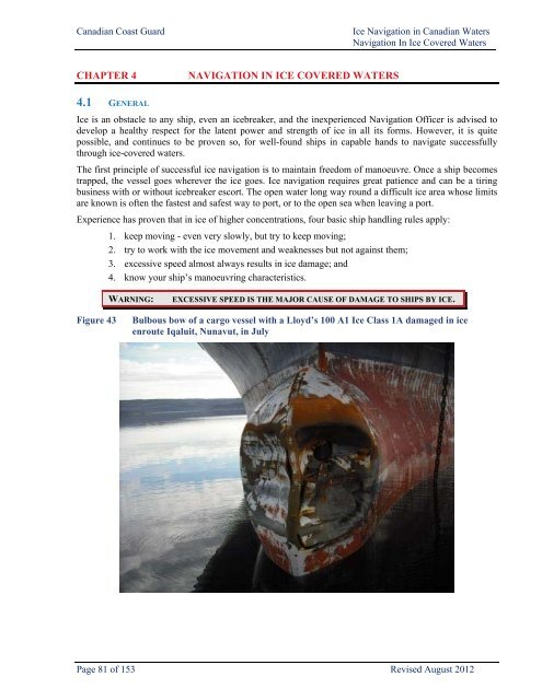
Figure 43<br />
Bulbous bow of a cargo vessel with a Lloyd’s 100 A1 Ice Class 1A damaged <strong>in</strong> <strong>ice</strong><br />
enroute Iqaluit, Nunavut, <strong>in</strong> July<br />
Page 81 of 153 Revised August 2012
Ice Navigation <strong>in</strong> <strong>Canadian</strong> Waters<br />
Navigation In Ice Covered Waters<br />
<strong>Canadian</strong> <strong>Coast</strong> <strong>Guard</strong><br />
4.2 REQUIREMENTS FOR SHIPS OPERATING IN ICE<br />
The propulsion plant and steer<strong>in</strong>g gear of any ship <strong>in</strong>tend<strong>in</strong>g to operate <strong>in</strong> <strong>ice</strong> must be reliable and must be<br />
capable of a fast response to manoeuvr<strong>in</strong>g orders. The <strong>navigation</strong>al and communications equipment must<br />
be equally reliable and particular attention should be paid to ma<strong>in</strong>ta<strong>in</strong><strong>in</strong>g radar at peak performance.<br />
Light and partly loaded ships should be ballasted as deeply as possible, but excessive trim by the stern is<br />
not recommended, as it cuts down manoeuvrability and <strong>in</strong>creases the possibility of <strong>ice</strong> damage to the more<br />
vulnerable lower area of the exposed bow. Eng<strong>in</strong>e room suction stra<strong>in</strong>ers should be able to be removed<br />
easily and to be kept clear of <strong>ice</strong> and snow. Good searchlights should be available to aid <strong>in</strong> visibility dur<strong>in</strong>g<br />
night <strong>navigation</strong> with or without <strong>ice</strong>breaker support.<br />
Ships navigat<strong>in</strong>g <strong>in</strong> <strong>ice</strong>-<strong>covered</strong> <strong>waters</strong> may experience delays and, therefore, should carry sufficient fresh<br />
water, supplies and manoeuvr<strong>in</strong>g fuel, especially vessels which use heavy bunker fuel for ma<strong>in</strong> propulsion.<br />
4.3 ADVERSE ENVIRONMENTAL CONDITIONS<br />
Ships and their equipment at sea <strong>in</strong> <strong>Canadian</strong> w<strong>in</strong>ters and <strong>in</strong> high latitudes are affected by the follow<strong>in</strong>g:<br />
<br />
<br />
<br />
<br />
<br />
<br />
<br />
<br />
low surface temperatures;<br />
high w<strong>in</strong>ds;<br />
low sea-water <strong>in</strong>jection temperatures;<br />
low humidity;<br />
<strong>ice</strong> conditions rang<strong>in</strong>g from slush <strong>ice</strong> to solid pack;<br />
snow, sleet, and freez<strong>in</strong>g ra<strong>in</strong>;<br />
fog and overcast, especially at the <strong>ice</strong>/water <strong>in</strong>terface; and<br />
superstructure ic<strong>in</strong>g when there is the great and dangerous possibility of heavy and rapid ic<strong>in</strong>g<br />
with consequent loss of stability.<br />
4.3.1 Superstructure Ic<strong>in</strong>g<br />
Superstructure ic<strong>in</strong>g is a complicated process which depends upon meteorological conditions, condition of<br />
load<strong>in</strong>g, and behaviour of the vessel <strong>in</strong> stormy weather, as well as on the size and location of the<br />
superstructure and rigg<strong>in</strong>g. The more common cause of <strong>ice</strong> formation is the deposit of water droplets on the<br />
vessel's structure. These droplets come from spray driven from wave crests and from ship-generated spray.<br />
Ice formation may also occur <strong>in</strong> conditions of snowfall, sea fog, (<strong>in</strong>clud<strong>in</strong>g Arctic sea smoke) a drastic fall<br />
<strong>in</strong> ambient temperature, and from the freez<strong>in</strong>g of ra<strong>in</strong>drops on contact with the vessel's structure. Ice<br />
formation may sometimes be caused or accentuated by water shipped on board and reta<strong>in</strong>ed on deck.<br />
Vessel ic<strong>in</strong>g is a function of the ship's course relative to the w<strong>in</strong>d and seas and generally is most severe <strong>in</strong><br />
the follow<strong>in</strong>g areas: stem, bulwark and bulwark rail, w<strong>in</strong>dward side of the superstructure and deckhouses,<br />
hawse pipes, anchors, deck gear, forecastle deck and upper deck, free<strong>in</strong>g ports, conta<strong>in</strong>ers, hatches, aerials,<br />
stays, shrouds, masts, spars, and associated rigg<strong>in</strong>g. It is important to ma<strong>in</strong>ta<strong>in</strong> the anchor w<strong>in</strong>dlass free of<br />
<strong>ice</strong> so that the anchor may be dropped <strong>in</strong> case of emergency. Constant spray enter<strong>in</strong>g the hawse pipes may<br />
freeze solid <strong>in</strong>side the pipe, also anchors stowed <strong>in</strong> recessed pockets may freeze <strong>in</strong> place, both conditions<br />
prevent<strong>in</strong>g lett<strong>in</strong>g the anchor go. It is good pract<strong>ice</strong> <strong>in</strong> freez<strong>in</strong>g spray to leave anchors slightly lowered <strong>in</strong><br />
the hawse pipe <strong>in</strong> order to free them from <strong>ice</strong> accretion when needed. It is also advisable to ma<strong>in</strong>ta<strong>in</strong><br />
secur<strong>in</strong>g claws <strong>in</strong> place <strong>in</strong> case of slippery brakes, so that the anchors can be readily released <strong>in</strong> the event of<br />
a power blackout.<br />
Page 82 of 153 Revised August 2012
<strong>Canadian</strong> <strong>Coast</strong> <strong>Guard</strong><br />
Ice Navigation <strong>in</strong> <strong>Canadian</strong> Waters<br />
Navigation In Ice Covered Waters<br />
Figure 44: Severe Ic<strong>in</strong>g Conditions Superstructure ic<strong>in</strong>g is possible<br />
whenever air temperatures are -<br />
2.2°C or less and w<strong>in</strong>ds are<br />
17 knots or more. It is very<br />
likely to take place when these<br />
conditions occur at the same<br />
time.<br />
In fresh water such as the Great<br />
Lakes and St. Lawrence River<br />
superstructure ic<strong>in</strong>g will occur at<br />
0°C and below, and accumulate<br />
faster than <strong>in</strong> salt water<br />
conditions.<br />
Generally speak<strong>in</strong>g, w<strong>in</strong>ds of<br />
Beaufort Force 5 may produce<br />
slight ic<strong>in</strong>g; w<strong>in</strong>ds of Force 7,<br />
moderate ic<strong>in</strong>g; and w<strong>in</strong>ds of<br />
above Force 8, severe ic<strong>in</strong>g.<br />
Under these conditions, the most <strong>in</strong>tensive <strong>ice</strong> formation takes place when w<strong>in</strong>d and sea come from ahead.<br />
In beam and quarter<strong>in</strong>g w<strong>in</strong>ds, <strong>ice</strong> accumulates more quickly on the w<strong>in</strong>dward side of the vessel, thus<br />
lead<strong>in</strong>g to a constant list which is extremely dangerous as the deck-immersion po<strong>in</strong>t could easily be reached<br />
with a loaded vessel.<br />
WARNING:<br />
VESSEL ICING MAY IMPAIR THE STABILITY AND SAFETY OF A SHIP.<br />
The effects of freez<strong>in</strong>g spray can be m<strong>in</strong>imized by slow<strong>in</strong>g down <strong>in</strong> heavy seas to reduce bow pound<strong>in</strong>g,<br />
runn<strong>in</strong>g with the sea, or seek<strong>in</strong>g more sheltered sea conditions near-shore or <strong>in</strong> sea <strong>ice</strong>. Another option may<br />
be to head to warmer <strong>waters</strong>, although this is not possible <strong>in</strong> many <strong>Canadian</strong> mar<strong>in</strong>e areas.<br />
Figure 45: Crew remov<strong>in</strong>g <strong>ice</strong> from bulwarks. Figure 46: Ice build-up on forecastle<br />
Under severe ic<strong>in</strong>g conditions, manual removal of <strong>ice</strong> may be the only method of prevent<strong>in</strong>g a capsize. It is<br />
important for the Master to consider the predicted duration of an ic<strong>in</strong>g storm and the rate at which <strong>ice</strong> is<br />
accumulat<strong>in</strong>g on his vessel <strong>in</strong> determ<strong>in</strong><strong>in</strong>g which strategy to follow.<br />
Page 83 of 153 Revised August 2012
Ice Navigation <strong>in</strong> <strong>Canadian</strong> Waters<br />
Navigation In Ice Covered Waters<br />
<strong>Canadian</strong> <strong>Coast</strong> <strong>Guard</strong><br />
Several tips for m<strong>in</strong>imiz<strong>in</strong>g ic<strong>in</strong>g hazards on fish<strong>in</strong>g vessels are:<br />
<br />
<br />
<br />
<br />
<br />
<br />
<br />
<br />
<br />
head for warmer water or a protected coastal area;<br />
place all fish<strong>in</strong>g gear, barrels, and deck gear below deck or fasten them to the deck as low as<br />
possible;<br />
lower and fasten cargo booms;<br />
cover deck mach<strong>in</strong>ery and boats;<br />
fasten storm rails;<br />
remove grat<strong>in</strong>gs from scuppers and move all objects which might prevent water dra<strong>in</strong>age from<br />
the deck;<br />
make the ship as watertight as possible;<br />
if the freeboard is high enough, fill all empty bottom tanks conta<strong>in</strong><strong>in</strong>g ballast pip<strong>in</strong>g with seawater;<br />
and<br />
establish reliable two-way radio communication with either a shore station or another ship.<br />
Freez<strong>in</strong>g spray warn<strong>in</strong>gs are <strong>in</strong>cluded <strong>in</strong> mar<strong>in</strong>e forecasts by Environment Canada. However, it is difficult<br />
to provide accurate ic<strong>in</strong>g forecasts as <strong>in</strong>dividual vessel characteristics have a significant effect on ic<strong>in</strong>g.<br />
Graphs assess<strong>in</strong>g the rate of ic<strong>in</strong>g based on air temperature, w<strong>in</strong>d speed, and sea-surface temperature can<br />
provide a guide to possible ic<strong>in</strong>g conditions, but should not be relied on to predict <strong>ice</strong> accumulation rates on<br />
a vessel. Caution should be exercised whenever gale-force w<strong>in</strong>ds are expected <strong>in</strong> comb<strong>in</strong>ation with air<br />
temperatures below -2°C.<br />
4.4 SIGNS OF ICE IN THE VICINITY<br />
When steam<strong>in</strong>g through open water, it may be possible to detect the approach of <strong>ice</strong> by the follow<strong>in</strong>g signs:<br />
(a) Ice bl<strong>in</strong>k: this is a fairly reliable sign and may be the first <strong>in</strong>dication that an <strong>ice</strong> field is <strong>in</strong> the<br />
vic<strong>in</strong>ity. It can usually be seen for some time before the <strong>ice</strong> itself is visible and appears as a<br />
lum<strong>in</strong>ous reflection on the underside of the clouds above the <strong>ice</strong>. Its clarity is <strong>in</strong>creased after a fresh<br />
snowfall. On clear days, <strong>ice</strong> bl<strong>in</strong>k is less apparent but may appear as a light or yellowish haze<br />
which would <strong>in</strong>dicate the presence of <strong>ice</strong>. Ice bl<strong>in</strong>k can sometimes be detected at night, either from<br />
the reflection of moonlight, or from the ambient starlight <strong>in</strong> clear weather.<br />
(b) The sight<strong>in</strong>g of small fragments of <strong>ice</strong> often <strong>in</strong>dicates that larger quantities are not far away.<br />
(c) Abrupt moderation of the sea and swell occur when approach<strong>in</strong>g an <strong>ice</strong> field from leeward.<br />
(d) In northern areas, and <strong>in</strong> Labrador and Newfoundland, the onset of fog often <strong>in</strong>dicates the presence<br />
of <strong>ice</strong> <strong>in</strong> the vic<strong>in</strong>ity.<br />
On a clear day there may be abnormal refraction of light caus<strong>in</strong>g distortion <strong>in</strong> the appearance of features.<br />
Although the <strong>ice</strong> field will be seen at a greater distance than would normally be possible without refraction,<br />
its characteristics may be magnified out of all proportion – it may even appear as giant cliffs of <strong>ice</strong> <strong>in</strong> the<br />
far distance, with breaks between them where the open water lies.<br />
The follow<strong>in</strong>g are signs of open water:<br />
(a) Water sky: dark patches on low clouds, sometimes almost black <strong>in</strong> comparison with the clouds,<br />
<strong>in</strong>dicate the presence of water below them. When the air is very clear this <strong>in</strong>dication is less evident.<br />
When <strong>ice</strong>bl<strong>in</strong>k is visible at night, the absence of bl<strong>in</strong>k <strong>in</strong> some sectors of the horizon may <strong>in</strong>dicate<br />
open water but cannot be assumed to be water sky.<br />
(b) Dark spots <strong>in</strong> fog give a similar <strong>in</strong>dication, but are not visible for as great a distance as the<br />
reflection on clouds.<br />
Page 84 of 153 Revised August 2012
<strong>Canadian</strong> <strong>Coast</strong> <strong>Guard</strong><br />
Ice Navigation <strong>in</strong> <strong>Canadian</strong> Waters<br />
Navigation In Ice Covered Waters<br />
(c)<br />
A dark bank on a cloud at high altitude <strong>in</strong>dicates the presence of patches of open water below,<br />
which could lead to larger areas of open water <strong>in</strong> the immediate vic<strong>in</strong>ity.<br />
NOTE:<br />
To accomplish effective <strong>ice</strong> management for the Grand Banks<br />
and <strong>Canadian</strong> eastern seaboard, it is imperative that sight<strong>in</strong>gs of<br />
<strong>ice</strong> and <strong>ice</strong>bergs be reported to ECAREG CANADA through the<br />
nearest <strong>Canadian</strong> <strong>Coast</strong> <strong>Guard</strong> MCTS Centre. These messages<br />
will be handled free of charge.<br />
4.5 SHIPS NAVIGATING INDEPENDENTLY<br />
Experience has shown that non-<strong>ice</strong>-strengthened ships with an open water speed of about 12 knots can<br />
become hopelessly beset <strong>in</strong> heavy concentrations of relatively light <strong>ice</strong> conditions, whereas <strong>ice</strong>strengthened<br />
ships with adequate power should be able to make progress through first-year <strong>ice</strong> of 6/10 to<br />
7/10 concentrations. Such ships are often able to proceed without any assistance other than rout<strong>in</strong>g adv<strong>ice</strong>.<br />
In concentrations of 6/10 or less, most vessels should be able to steer at slow speed around the floes <strong>in</strong> open<br />
pack <strong>ice</strong> without com<strong>in</strong>g <strong>in</strong>to contact with very many of them.<br />
4.5.1 Enter<strong>in</strong>g the Ice<br />
The route recommended by the Ice Super<strong>in</strong>tendent through the appropriate report<strong>in</strong>g system i.e. ECAREG<br />
or NORDREG, is based on the latest available <strong>in</strong>formation and Masters are advised to adjust their course<br />
accord<strong>in</strong>gly. The follow<strong>in</strong>g notes on ship-handl<strong>in</strong>g <strong>in</strong> <strong>ice</strong> have proven helpful:<br />
(a) Do not enter <strong>ice</strong> if an alternative, although longer, open water route is available.<br />
(b) It is very easy and extremely dangerous to underestimate the hardness of <strong>ice</strong>.<br />
(c) Enter the <strong>ice</strong> at low speed to receive the <strong>in</strong>itial impact; once <strong>in</strong>to the pack, <strong>in</strong>crease speed gradually<br />
to ma<strong>in</strong>ta<strong>in</strong> headway and control of the ship, but do not let the speed <strong>in</strong>crease beyond the po<strong>in</strong>t at<br />
which she might suffer <strong>ice</strong> damage. Particular attention should be paid to applied power <strong>in</strong> areas of<br />
weak <strong>ice</strong> or open leads, pools, etc. where the speed might <strong>in</strong>crease unnot<strong>ice</strong>d to dangerous levels if<br />
power is not taken off.<br />
(d) Be prepared to go "Full Astern" at any time.<br />
(e) Navigation <strong>in</strong> pack <strong>ice</strong> after dark should not be attempted without high-power searchlights which<br />
can be controlled easily from the bridge; if poor visibility precludes progress, heave to <strong>in</strong> the <strong>ice</strong><br />
and keep the propeller turn<strong>in</strong>g slowly as it is less susceptible to <strong>ice</strong> damage than if it were<br />
completely stopped, blocks of <strong>ice</strong> will also be prevented from jamm<strong>in</strong>g between the blades and the<br />
hull.<br />
(f) Propellers and rudders are the most vulnerable parts of the ship; ships should go astern <strong>in</strong> <strong>ice</strong> with<br />
extreme care, and always with the rudder amidships. If required to ram <strong>ice</strong> when brought to a halt,<br />
ships should not go astern <strong>in</strong>to unbroken <strong>ice</strong>, but should move astern only <strong>in</strong> the channel previously<br />
cut by their own passage.<br />
(g) All forms of glacial <strong>ice</strong> (<strong>ice</strong>bergs, bergy bits, growlers) <strong>in</strong> the pack should be given a wide berth, as<br />
they are current-driven whereas the pack is w<strong>in</strong>d-driven. Large features of old <strong>ice</strong> may be mov<strong>in</strong>g<br />
<strong>in</strong> a direction up-w<strong>in</strong>d or across w<strong>in</strong>d accord<strong>in</strong>g to the direction of the current.<br />
(h) Wherever possible, pressure ridges should be avoided and a passage through pack <strong>ice</strong> under<br />
pressure should not be attempted. The ship may have to be stopped <strong>in</strong> the <strong>ice</strong> until the pressure<br />
event is ended.<br />
(i) When a ship navigat<strong>in</strong>g <strong>in</strong>dependently becomes beset, it usually requires <strong>ice</strong>breaker assistance to<br />
free it. However, ships <strong>in</strong> ballast can sometimes free themselves by pump<strong>in</strong>g and transferr<strong>in</strong>g<br />
Page 85 of 153 Revised August 2012
Ice Navigation <strong>in</strong> <strong>Canadian</strong> Waters<br />
Navigation In Ice Covered Waters<br />
<strong>Canadian</strong> <strong>Coast</strong> <strong>Guard</strong><br />
ballast from side to side, and it may require very little change <strong>in</strong> trim or list to release the ship,<br />
especially <strong>in</strong> high-friction areas of heavy snow-cover.<br />
The Master may wish to engage the serv<strong>ice</strong>s of an Ice Navigator <strong>in</strong> the Arctic.<br />
4.6 ICEBREAKERS<br />
The <strong>Canadian</strong> <strong>Coast</strong> <strong>Guard</strong> has a limited number of <strong>ice</strong>breakers available for the escort and support of<br />
shipp<strong>in</strong>g. These <strong>ice</strong>breakers are heavily committed and cannot always be provided on short not<strong>ice</strong> when<br />
requested. Therefore, it is important for the ECAREG CANADA Off<strong>ice</strong> or Ice Operations Centre to be kept<br />
<strong>in</strong>formed about the position and projected movements of vessels when <strong>ice</strong> is present. Failure to follow the<br />
report<strong>in</strong>g procedures, by vessels unsure of their ability to cope with prevail<strong>in</strong>g <strong>ice</strong> conditions on their own,<br />
will only add to the difficulties of provid<strong>in</strong>g <strong>ice</strong>breakers and can lead to serious delays.<br />
<strong>Canadian</strong> <strong>Coast</strong> <strong>Guard</strong> <strong>ice</strong>breakers, many of which carry helicopters for <strong>ice</strong> reconnaissance, have operated<br />
<strong>in</strong> <strong>ice</strong> for many years, from the Great Lakes to as far north as the North Pole. Their Command<strong>in</strong>g Off<strong>ice</strong>rs<br />
and crews are highly skilled and thoroughly experienced <strong>in</strong> the specialist fields of <strong>ice</strong> <strong>navigation</strong>,<br />
<strong>ice</strong>break<strong>in</strong>g, and <strong>ice</strong> escort. The fullest co-operation with the Command<strong>in</strong>g Off<strong>ice</strong>r of an <strong>ice</strong>breaker is,<br />
therefore, requested from a ship or convoy under escort. For progress to be made, it is essential that escort<br />
operations be under the direction of the Command<strong>in</strong>g Off<strong>ice</strong>r of the <strong>ice</strong>breaker.<br />
NOTE:<br />
No escort will be provided unless full co-operation is obta<strong>in</strong>ed.<br />
4.6.1 Communicat<strong>in</strong>g with Icebreakers<br />
Once a vessel has requested <strong>ice</strong>breaker assistance, a radio watch should be kept on 2182 kHz and channel<br />
16 VHF (156.8 MHz). Difficulty is often experienced by <strong>ice</strong>breakers <strong>in</strong> mak<strong>in</strong>g <strong>in</strong>itial contact with these<br />
vessels, often with the result of lost time and extra fuel consumption. MF and VHF rema<strong>in</strong> as proven<br />
communications tools and should be utilised to ma<strong>in</strong>ta<strong>in</strong> contact with the <strong>ice</strong>breakers.<br />
A cont<strong>in</strong>uous radiotelephone watch on an agreed frequency should also be ma<strong>in</strong>ta<strong>in</strong>ed on the bridges of all<br />
ships work<strong>in</strong>g with <strong>Coast</strong> <strong>Guard</strong> <strong>ice</strong>breakers. Ships should be capable of work<strong>in</strong>g one or more of the<br />
follow<strong>in</strong>g MF and VHF frequencies:<br />
2237 kHz MF<br />
2134 kHz MF<br />
2738 kHz MF<br />
156.3 MHz VHF Channel 6<br />
Table 8 lists the letter, sound, visual, or radiotelephony signals that are for use between <strong>ice</strong>breakers and<br />
assisted ships. These signals are accepted <strong>in</strong>ternationally and they are restricted to the significance<br />
<strong>in</strong>dicated <strong>in</strong> the table.<br />
While under escort, cont<strong>in</strong>uous and close communications must be ma<strong>in</strong>ta<strong>in</strong>ed. Communications normally<br />
will be by radiotelephone on a selected and mutually agreed <strong>in</strong>ter-ship VHF work<strong>in</strong>g frequency. It is vital<br />
to <strong>in</strong>form the Ice Operations Centre and <strong>ice</strong>breaker of any change <strong>in</strong> the state of your vessel while await<strong>in</strong>g<br />
an <strong>ice</strong>breaker escort.<br />
Page 86 of 153 Revised August 2012
<strong>Canadian</strong> <strong>Coast</strong> <strong>Guard</strong><br />
Ice Navigation <strong>in</strong> <strong>Canadian</strong> Waters<br />
Navigation In Ice Covered Waters<br />
Table 8<br />
Code<br />
Letters<br />
WM<br />
Operational signals to be used to supplement radiotelephone communication between<br />
<strong>ice</strong>breaker and assisted vessel (s)<br />
Icebreaker Instruction<br />
Icebreaker support is now commenc<strong>in</strong>g. Use<br />
special <strong>ice</strong>breaker support signals and keep<br />
cont<strong>in</strong>uous watch for sound, visual, or<br />
radiotelephony signals<br />
Assisted Vessel(s) Response<br />
A Go ahead (proceed along the <strong>ice</strong> channel) I am go<strong>in</strong>g ahead. (I am proceed<strong>in</strong>g along<br />
the <strong>ice</strong> channel)<br />
G I am go<strong>in</strong>g ahead, follow me I am go<strong>in</strong>g ahead. I am follow<strong>in</strong>g you<br />
J<br />
Do not follow me. (proceed along the <strong>ice</strong><br />
channel)<br />
P Slow down I am slow<strong>in</strong>g down<br />
I will not follow you (I will proceed along<br />
the <strong>ice</strong> channel)<br />
N Stop your eng<strong>in</strong>es I am stopp<strong>in</strong>g my eng<strong>in</strong>es<br />
H Reverse your eng<strong>in</strong>es I am revers<strong>in</strong>g my eng<strong>in</strong>es<br />
L You should stop your vessel <strong>in</strong>stantly I am stopp<strong>in</strong>g my vessel<br />
4 Stop. I am <strong>ice</strong>bound I am stopp<strong>in</strong>g my vessel<br />
Q Shorten the distance between vessels I am shorten<strong>in</strong>g the distance<br />
B Increase the distance between vessels I am <strong>in</strong>creas<strong>in</strong>g the distance<br />
Y Be ready to take (or cast off) the tow l<strong>in</strong>e I am ready to take (or cast off) the tow l<strong>in</strong>e<br />
FE<br />
WO<br />
Stop your headway (given only to a ship <strong>in</strong><br />
an <strong>ice</strong> channel ahead of an <strong>ice</strong>breaker)<br />
Icebreaker support is f<strong>in</strong>ished. Proceed to<br />
your dest<strong>in</strong>ation<br />
5 Attention Attention<br />
I am stopp<strong>in</strong>g headway<br />
Signals which may be used dur<strong>in</strong>g <strong>ice</strong>break<strong>in</strong>g operations<br />
E I am alter<strong>in</strong>g my course to starboard I am alter<strong>in</strong>g my course to starboard<br />
I I am alter<strong>in</strong>g my course to port I am alter<strong>in</strong>g my course to port<br />
S My eng<strong>in</strong>es are go<strong>in</strong>g astern My eng<strong>in</strong>es are go<strong>in</strong>g astern<br />
M<br />
My vessel is stopped and mak<strong>in</strong>g no way<br />
through the water<br />
My vessel is stopped and mak<strong>in</strong>g no<br />
progress through the water<br />
NOTES: EMERGENCY STOP SIGNAL: Icebreakers have red revolv<strong>in</strong>g<br />
lights placed high up at the after end of the superstructure, visible<br />
from astern, which will be activated when an EMERGENCY<br />
STOP is required by the escorted ship or ships.<br />
The signal "K" by sound or light may be used by an <strong>ice</strong>breaker to rem<strong>in</strong>d ships of their obligation to listen<br />
cont<strong>in</strong>uously on their radios.<br />
Page 87 of 153 Revised August 2012
Ice Navigation <strong>in</strong> <strong>Canadian</strong> Waters<br />
Navigation In Ice Covered Waters<br />
<strong>Canadian</strong> <strong>Coast</strong> <strong>Guard</strong><br />
If more than one vessel is assisted, the distance between vessels should be as constant as possible; watch<br />
the speed of your own vessel and of the vessel ahead. Should the speed of your own vessel go down, give<br />
an attention signal to the vessel follow<strong>in</strong>g.<br />
The visual signals are seldom used <strong>in</strong> pract<strong>ice</strong>, but are listed <strong>in</strong> case vo<strong>ice</strong> radio communication fails.<br />
The use of these signals does not relieve any vessel from comply<strong>in</strong>g with the<br />
International Regulations for Prevent<strong>in</strong>g Collisions at Sea.<br />
4.6.2 Report Required Before Escort Commences<br />
Before escort or assistance commences, the <strong>ice</strong>breaker will require some or all of the follow<strong>in</strong>g <strong>in</strong>formation<br />
to assess a ship's capabilities while under escort <strong>in</strong> <strong>ice</strong>:<br />
<br />
<br />
<br />
<br />
<br />
<br />
<br />
<br />
<br />
<br />
<br />
<br />
<br />
<br />
<br />
vessel name, type and call sign;<br />
Lloyds/IMO number;<br />
owner/agent name;<br />
country of registry;<br />
tonnage (gross and net);<br />
ship's length and beam;<br />
port of departure and dest<strong>in</strong>ation;<br />
cargo type and amount (tonnage);<br />
<strong>ice</strong> navigator’s name, if embarked;<br />
open water speed;<br />
<strong>ice</strong> class (if any) and classification society;<br />
drafts - forward and aft;<br />
number of propellers and rudders;<br />
shaft horsepower;<br />
propulsion plant (whether diesel or turb<strong>in</strong>e, and astern power expressed as a percentage of full<br />
ahead power) and the type of fuel for the ma<strong>in</strong> propulsion (e.g. heavy bunker, diesel, LNG, etc.);<br />
and<br />
radiotelephone work<strong>in</strong>g frequencies, communications systems <strong>in</strong>clud<strong>in</strong>g telephone and/or fax<br />
number.<br />
The onus is on the escorted vessel to advise the <strong>ice</strong>breaker of any deficiencies that exist on their<br />
vessel.<br />
4.6.3 Icebreak<strong>in</strong>g Escort Operations<br />
The follow<strong>in</strong>g are comments on aspects of <strong>ice</strong>breaker escort procedures:<br />
(a) Track width: Progress through <strong>ice</strong> by an escorted ship depends to a great extent on the width of<br />
the track made by the <strong>ice</strong>breaker, which is directly related to the speed of the forward progress of<br />
the <strong>ice</strong>breaker and the distance between the <strong>ice</strong>breaker and the ship follow<strong>in</strong>g.<br />
(b) Icebreaker beam: When an <strong>ice</strong>breaker is break<strong>in</strong>g a track through large heavy floes at slow<br />
speed, the track will be about 30 to 40 per cent wider than the beam of the <strong>ice</strong>breaker. At high<br />
speed, and if the <strong>ice</strong> is of a type which can be broken by the action of the stern wave (wake), the<br />
track may be as much as three times that of the <strong>ice</strong>breaker's beam.<br />
Page 88 of 153 Revised August 2012
<strong>Canadian</strong> <strong>Coast</strong> <strong>Guard</strong><br />
Ice Navigation <strong>in</strong> <strong>Canadian</strong> Waters<br />
Navigation In Ice Covered Waters<br />
(c)<br />
(d)<br />
M<strong>in</strong>imum escort distance: The m<strong>in</strong>imum distance will be determ<strong>in</strong>ed by the Command<strong>in</strong>g<br />
Off<strong>ice</strong>r of the <strong>ice</strong>breaker on the basis of distance required by the escorted ship(s) to come to a<br />
complete stop, after revers<strong>in</strong>g to full astern from normal full ahead speed. Once this distance has<br />
been established, it is the responsibility of the ship under escort to see that it is ma<strong>in</strong>ta<strong>in</strong>ed. If the<br />
escorted vessel is unable to ma<strong>in</strong>ta<strong>in</strong> the m<strong>in</strong>imum escort distance and is fall<strong>in</strong>g back, the<br />
<strong>ice</strong>breaker should be <strong>in</strong>formed at once to avoid the possibility of besetment and result<strong>in</strong>g delay.<br />
Maximum escort distance: Maximum distance is determ<strong>in</strong>ed on the basis of <strong>ice</strong> conditions and<br />
the distance at which the track will rema<strong>in</strong> open or nearly so. Increas<strong>in</strong>g this distance creates the<br />
possibility of besetment, which would necessitate a free<strong>in</strong>g operation by the <strong>ice</strong>breaker. If the<br />
escorted vessel is unable to ma<strong>in</strong>ta<strong>in</strong> the maximum escort distance, the <strong>ice</strong>breaker should be<br />
<strong>in</strong>formed at once to avoid the possibility of besetment and result<strong>in</strong>g delay.<br />
(e) Ma<strong>in</strong>ta<strong>in</strong><strong>in</strong>g the escort distance: Masters are requested to ma<strong>in</strong>ta<strong>in</strong> the required escort distance<br />
astern of the <strong>ice</strong>breaker to the best of their ability. The progress made depends to a very great<br />
extent on the correct escort distance be<strong>in</strong>g ma<strong>in</strong>ta<strong>in</strong>ed. This distance is dictated by the exist<strong>in</strong>g <strong>ice</strong><br />
conditions and the risk of collision by the escorted vessel overtak<strong>in</strong>g the <strong>ice</strong>breaker.<br />
Figure 47: The Command<strong>in</strong>g Off<strong>ice</strong>r of the <strong>ice</strong>breaker will determ<strong>in</strong>e a safe escort distance<br />
(f)<br />
(g)<br />
(h)<br />
Ice concentration: With 9+/10 concentrations, the track will have a tendency to close quickly<br />
beh<strong>in</strong>d the <strong>ice</strong>breaker, thus necessitat<strong>in</strong>g very close escort at a speed determ<strong>in</strong>ed by the<br />
Command<strong>in</strong>g Off<strong>ice</strong>r of the <strong>ice</strong>breaker and the type of <strong>ice</strong> encountered.<br />
Ice pressure: When the <strong>ice</strong> concentration is 9+/10 and under pressure, the track will close very<br />
rapidly. Progress will be almost impossible because the track, be<strong>in</strong>g marg<strong>in</strong>ally wider than the<br />
beam of the <strong>ice</strong>breaker, will close and result <strong>in</strong> the escorted ship becom<strong>in</strong>g beset.<br />
Effect of escort on width of track: When an <strong>ice</strong>breaker makes a track, it causes outward<br />
movement of the floes. The width of the track depends on the extent of this outward movement<br />
together with the amount of open water available for floe movement. A longer escort distance<br />
allows a longer period of movement that results <strong>in</strong> a wider track.<br />
Page 89 of 153 Revised August 2012
Ice Navigation <strong>in</strong> <strong>Canadian</strong> Waters<br />
Navigation In Ice Covered Waters<br />
<strong>Canadian</strong> <strong>Coast</strong> <strong>Guard</strong><br />
(i)<br />
(j)<br />
(k)<br />
(l)<br />
(m)<br />
(n)<br />
(o)<br />
Speed: When an <strong>ice</strong>breaker makes contact with <strong>ice</strong> floes on either side of the track, they may be<br />
forced outward with sufficient momentum to overcome the <strong>in</strong>draft at the stern; otherwise, some<br />
blocks and small floes will be drawn <strong>in</strong>to the broken track. Most tracks made by <strong>ice</strong>breakers will<br />
conta<strong>in</strong> <strong>ice</strong> rubble, which may also conta<strong>in</strong> floes, which could damage an escorted vessel at<br />
excessive speed.<br />
If an <strong>ice</strong>breaker proceeds at slow speed through <strong>ice</strong>, floes will slide along her hull and rema<strong>in</strong><br />
<strong>in</strong>tact, with the exception of small pieces that may break away from the lead<strong>in</strong>g edges. At high<br />
speeds the floes will be shattered <strong>in</strong>to many pieces. The <strong>ice</strong>breaker will, therefore, proceed at a<br />
speed which will break floes <strong>in</strong>to as many pieces as possible, thus reduc<strong>in</strong>g the possibility of<br />
damage to the ship follow<strong>in</strong>g <strong>in</strong> the track.<br />
Escorted ship beset: When a ship under escort has stopped for any reason, the <strong>ice</strong>breaker should<br />
be notified immediately. If the ship is beset, the eng<strong>in</strong>es should be kept slow ahead to keep the <strong>ice</strong><br />
away from the propellers. The eng<strong>in</strong>es should be stopped only when requested by the <strong>ice</strong>breaker.<br />
Free<strong>in</strong>g a beset vessel: Free<strong>in</strong>g a ship that has become beset dur<strong>in</strong>g escort is usually carried out<br />
by the <strong>ice</strong>breaker back<strong>in</strong>g down the track, cutt<strong>in</strong>g out <strong>ice</strong> on either bow of the beset ship, and<br />
pass<strong>in</strong>g astern along the vessel's side before mov<strong>in</strong>g both vessels ahead. To free a ship beset while<br />
navigat<strong>in</strong>g <strong>in</strong>dependently, the <strong>ice</strong>breaker will normally approach from astern and cross close ahead<br />
at an angle of 20 to 30 degrees to the beset ship's course. Such an approach may be made on either<br />
side <strong>in</strong> moderate w<strong>in</strong>ds. In strong w<strong>in</strong>ds at a wide angle to the track, a decision as to which side the<br />
cross-ahead is made will be determ<strong>in</strong>ed by which of the two ships is more <strong>in</strong>fluenced by the w<strong>in</strong>d.<br />
On occasion, the <strong>ice</strong>breaker may elect to pass down one side of the beset vessel, turn astern of her<br />
and pass up on the other side, thereby releas<strong>in</strong>g pressure from both sides.<br />
Systems of escort: When a ship becomes beset dur<strong>in</strong>g escort, the normal procedure is for the<br />
<strong>ice</strong>breaker to back up to free her and then proceed ahead with the escorted ship follow<strong>in</strong>g.<br />
However, when progress is slow, the Free and Proceed system may be used, <strong>in</strong> which the beset ship<br />
is directed to proceed up the track made by the <strong>ice</strong>breaker while back<strong>in</strong>g up, the <strong>ice</strong>breaker then<br />
follow<strong>in</strong>g beh<strong>in</strong>d. Before the escorted vessel reaches the end of the previously broken <strong>ice</strong>breaker<br />
track, the <strong>ice</strong>breaker proceeds at full speed to overtake and pass the escorted vessel. This cuts down<br />
the number of free<strong>in</strong>g operations and improves progress.<br />
Red warn<strong>in</strong>g lights and air horn: When escort<strong>in</strong>g ships <strong>in</strong> <strong>ice</strong>, <strong>Canadian</strong> <strong>Coast</strong> <strong>Guard</strong><br />
<strong>ice</strong>breakers use two rotat<strong>in</strong>g red lights to <strong>in</strong>dicate that the <strong>ice</strong>breaker has become stopped. In most<br />
cases these lights are placed <strong>in</strong> a vertical l<strong>in</strong>e 1.8 metres apart abaft the ma<strong>in</strong>mast and are visible<br />
for at least two miles. However, construction restrictions of some <strong>ice</strong>breakers necessitate that these<br />
lights be placed horizontally <strong>in</strong> roughly the same aft-fac<strong>in</strong>g position.<br />
As an additional warn<strong>in</strong>g signal, all <strong>ice</strong>breakers are fitted with and use a zet-horn, fac<strong>in</strong>g aft,<br />
audible up to 5 nautical miles, which sounds simultaneously with the red warn<strong>in</strong>g lights when they<br />
are activated. Prior to commencement of escort, all vessels will familiarize themselves with the<br />
position<strong>in</strong>g and operation of these red rotat<strong>in</strong>g lights and the zet-horn.<br />
Icebreaker stopped: Whenever the red revolv<strong>in</strong>g lights are displayed and the horn sounded, either<br />
separately or simultaneously, it signifies that the <strong>ice</strong>breaker has come to a standstill and is unable to<br />
make further progress without back<strong>in</strong>g up. Dur<strong>in</strong>g close escort work, a lookout shall always be kept<br />
for the flash<strong>in</strong>g red light. The Master of the escorted ship should treat these signals with extreme<br />
urgency and immediately reverse eng<strong>in</strong>es to full speed astern. The rudder should be put hard over<br />
to <strong>in</strong>crease <strong>ice</strong>-friction on the hull as long as headway is carried, until all forward motion has<br />
ceased, then the rudder must be returned to the amidships position.<br />
Icebreaker stopp<strong>in</strong>g without warn<strong>in</strong>g: Masters are cautioned that, because of unexpected <strong>ice</strong><br />
conditions or <strong>in</strong> other emergency situations, the <strong>ice</strong>breaker may stop or otherwise manoeuvre ahead<br />
Page 90 of 153 Revised August 2012
<strong>Canadian</strong> <strong>Coast</strong> <strong>Guard</strong><br />
Ice Navigation <strong>in</strong> <strong>Canadian</strong> Waters<br />
Navigation In Ice Covered Waters<br />
of the escorted ship without these warn<strong>in</strong>g signals. Masters must always be prepared to take prompt<br />
action to avoid overrunn<strong>in</strong>g the <strong>ice</strong>breaker.<br />
Figure 48: Icebreaker back<strong>in</strong>g alongside vessel to free it from the <strong>ice</strong><br />
(p)<br />
(q)<br />
(r)<br />
Tow<strong>in</strong>g <strong>in</strong> <strong>ice</strong>: This procedure would only be undertaken <strong>in</strong> emergencies as there is an <strong>in</strong>herent<br />
risk of damage to both vessels. The Command<strong>in</strong>g Off<strong>ice</strong>r of an <strong>ice</strong>breaker who receives a request<br />
for a tow will judge whether or not the situation calls for such extreme measures. <strong>Canadian</strong> <strong>Coast</strong><br />
<strong>Guard</strong> <strong>ice</strong>breakers are not equipped for close-coupled tow<strong>in</strong>g operations. The <strong>Canadian</strong> <strong>Coast</strong><br />
<strong>Guard</strong> has a policy and operational procedures on Assistance to Disabled Vessels that can be<br />
referenced onl<strong>in</strong>e at http://www.ccg-gcc.gc.ca/Publications/Policy-Assistance-Disabled-Vessels.<br />
Anchor<strong>in</strong>g <strong>in</strong> <strong>ice</strong>: Anchor<strong>in</strong>g <strong>in</strong> the presence of <strong>ice</strong> is not recommended except <strong>in</strong> an emergency,<br />
but if such anchor<strong>in</strong>g is necessary, only the m<strong>in</strong>imum amount of cable should be used and the<br />
capstan/w<strong>in</strong>dlass should be available for immediate use. The eng<strong>in</strong>es must be on standby, or kept<br />
runn<strong>in</strong>g, if the start-up time is more than 20 m<strong>in</strong>utes. If the water is too deep to let go an anchor,<br />
the ship may be stopped <strong>in</strong> fast <strong>ice</strong> (when the conditions permit). When off-shore <strong>in</strong> deep water, a<br />
ship can usually safely stop <strong>in</strong> the drift <strong>ice</strong> without an anchor down when darkness or poor<br />
visibility prevents further progress. The ship will then drift with the <strong>ice</strong> and may be turned around<br />
by the <strong>ice</strong>, but will be quite safe if properly placed before shutt<strong>in</strong>g down.<br />
Convoys: Convoys of ships may be formed by the Command<strong>in</strong>g Off<strong>ice</strong>r of the <strong>ice</strong>breaker, after<br />
consultation with the appropriate shore authority. Dur<strong>in</strong>g operations <strong>in</strong> <strong>ice</strong>, this action will best aid<br />
the movement of the maximum number of ships when there are an <strong>in</strong>sufficient number of<br />
<strong>ice</strong>breakers of suitable capacity available to facilitate the escort of ships proceed<strong>in</strong>g to or from<br />
adjacent areas or ports.<br />
The Command<strong>in</strong>g Off<strong>ice</strong>r of the <strong>ice</strong>breaker will determ<strong>in</strong>e the order of station with<strong>in</strong> the convoy,<br />
to be arranged to expedite the movement of the convoy through the <strong>ice</strong> (not necessarily on "first<br />
come-first served" basis). The ships <strong>in</strong> the convoy are responsible for arrang<strong>in</strong>g and ma<strong>in</strong>ta<strong>in</strong><strong>in</strong>g a<br />
Page 91 of 153 Revised August 2012
Ice Navigation <strong>in</strong> <strong>Canadian</strong> Waters<br />
Navigation In Ice Covered Waters<br />
<strong>Canadian</strong> <strong>Coast</strong> <strong>Guard</strong><br />
suitable and safe distance between <strong>in</strong>dividual vessels. The <strong>ice</strong>breaker will designate the required<br />
distance to be ma<strong>in</strong>ta<strong>in</strong>ed between itself and the lead ship of the convoy.<br />
If the <strong>ice</strong> conditions should change on route, or if some vessels have difficulty <strong>in</strong> follow<strong>in</strong>g the<br />
vessel ahead, the Command<strong>in</strong>g Off<strong>ice</strong>r of the <strong>ice</strong>breaker may change the order of convoy station so<br />
that ships with<strong>in</strong> the convoy can assist the progress of others less capable than themselves<br />
4.7 EFFECT OF ICE AND SNOW ON SHIP PERFORMANCE<br />
Ships not specifically designed and constructed for <strong>ice</strong> <strong>navigation</strong> must consider the suitability and best<br />
usage of their exist<strong>in</strong>g propulsion and control systems, <strong>in</strong> addition to hull strength, for <strong>navigation</strong> <strong>in</strong> <strong>ice</strong><strong>covered</strong><br />
<strong>waters</strong>.<br />
4.7.1 Ship Resistance<br />
The resistance of a ship is greater <strong>in</strong> level <strong>ice</strong> than <strong>in</strong> open water. As <strong>ice</strong> thickness and/or <strong>ice</strong> strength<br />
<strong>in</strong>creases, the ship must <strong>in</strong>crease power to ma<strong>in</strong>ta<strong>in</strong> its speed. However, even <strong>in</strong> open pack <strong>ice</strong> or <strong>in</strong> heavier<br />
<strong>ice</strong> concentrations, the navigator must use caution and avoid excessive speed.<br />
In general it can be said that rafted, ridged, and rubbled <strong>ice</strong> present significant impediments to the progress<br />
of a ship. Caution should also be used when navigat<strong>in</strong>g through level <strong>ice</strong> with occasional hummocks or<br />
rafted areas or <strong>in</strong>clusions of old <strong>ice</strong>.<br />
WARNING:<br />
ANY SHIP THAT IS NOT STRENGTHENED FOR OPERATING IN ICE<br />
SHOULD AVOID LARGE UNBROKEN ICE FLOES, PARTICULARLY IF THE<br />
ICE IS DEFORMED BY RAFTS, RIDGES, OR RUBBLE.<br />
When the <strong>ice</strong> thickness exceeds that <strong>in</strong> which the ship can make cont<strong>in</strong>uous progress, (such as when the<br />
ship encounters old <strong>ice</strong>, ridges, rafts, or hummocks), the ship could resort to ramm<strong>in</strong>g if the ship’s design<br />
and structural strength permits.<br />
It is important that the <strong>ice</strong> navigator understands how much impact from the <strong>ice</strong> the vessel can withstand<br />
without suffer<strong>in</strong>g damage, and at what speed hull damage is likely to be <strong>in</strong>flicted by the <strong>ice</strong> environment<br />
currently be<strong>in</strong>g experienced.<br />
The <strong>in</strong>fluence of snow on ship performance varies directly with snow thickness and snow type, and greatly<br />
<strong>in</strong>creases ship resistance. The friction coefficient between snow and a ship's hull varies with the<br />
consistency and wetness of the snow; wetter snow has a higher friction coefficient than dry snow. In certa<strong>in</strong><br />
environmental conditions the snow will be quite "sticky" whereas, <strong>in</strong> others, it will be very dry and brittle.<br />
One rule of thumb suggests that resistance from snow cover can be approximated by add<strong>in</strong>g half the snow<br />
thickness to the observed <strong>ice</strong> thickness and assess<strong>in</strong>g performance <strong>in</strong> <strong>ice</strong> of the <strong>in</strong>creased calculated<br />
thickness. Resistance <strong>in</strong> "sticky" snow is very difficult to predict, but it can be very high: equal to, or<br />
greater than, the <strong>ice</strong>break<strong>in</strong>g resistance.<br />
Low friction coat<strong>in</strong>gs and hull form are important elements <strong>in</strong> ship performance <strong>in</strong> snow-<strong>covered</strong> <strong>ice</strong>. In<br />
ramm<strong>in</strong>g mode a low-friction hull coat<strong>in</strong>g will facilitate extraction astern after each ram, as well as<br />
permitt<strong>in</strong>g each ram to proceed further ahead than would be possible with a bare steel hull surface.<br />
4.7.2 Ship Manoeuvr<strong>in</strong>g<br />
The features of hull shape that <strong>in</strong>fluence manoeuvrability <strong>in</strong> <strong>ice</strong> to the greatest extent are length-to-breadth<br />
ratio, flare, mid-body, and bow and stern shape. Manoeuvrability is also greatly <strong>in</strong>fluenced by <strong>ice</strong><br />
conditions, such as: thickness, coverage, pressure, and shear zone conditions. The diameter of a ship's<br />
turn<strong>in</strong>g circle <strong>in</strong>creases as the thickness of the <strong>ice</strong> <strong>in</strong>creases. Turn<strong>in</strong>g <strong>in</strong> level <strong>ice</strong> conditions is generally<br />
<strong>in</strong>fluenced by the degree of conf<strong>in</strong>ement imposed by the surround<strong>in</strong>g <strong>ice</strong>. Steady turns are recommended<br />
Page 92 of 153 Revised August 2012
<strong>Canadian</strong> <strong>Coast</strong> <strong>Guard</strong><br />
Ice Navigation <strong>in</strong> <strong>Canadian</strong> Waters<br />
Navigation In Ice Covered Waters<br />
for most vessels that are not as manoeuvrable as <strong>ice</strong>breakers, however it is more common for <strong>ice</strong>breakers to<br />
use star or channel breakout manoeuvres as a faster means of turn<strong>in</strong>g. These manoeuvres are described <strong>in</strong><br />
subsection 4.9.1. Heel<strong>in</strong>g systems have been demonstrated to be effective for most <strong>ice</strong>break<strong>in</strong>g ships,<br />
especially <strong>in</strong> snow-<strong>covered</strong> <strong>ice</strong> situations.<br />
4.7.3 Structural Capability<br />
A ship's performance <strong>in</strong> <strong>ice</strong> can be limited by the hull structure's capability to withstand <strong>ice</strong> impacts.<br />
Different modes of operation and <strong>ice</strong> regimes will generate different magnitudes of <strong>ice</strong> impact forces. For<br />
example, a ship encounter<strong>in</strong>g first-year <strong>ice</strong> will experience lower impact forces than a ship encounter<strong>in</strong>g<br />
old <strong>ice</strong>. A ship – usually an <strong>ice</strong>breaker - which is required to ram <strong>ice</strong> features aggressively with the<br />
<strong>in</strong>tention of protect<strong>in</strong>g less capable ships or structures will, of necessity, <strong>in</strong>cur higher impact forces to break<br />
<strong>ice</strong> which would damage that which they are protect<strong>in</strong>g. In terms of overall magnitude, ramm<strong>in</strong>g operations<br />
generate the largest forces on the ship's structure, and be<strong>in</strong>g repetitive, they may cause cumulative damage.<br />
4.7.4 Performance Enhanc<strong>in</strong>g Systems<br />
Performance enhanc<strong>in</strong>g systems are designed to reduce the power necessary for propulsion and to <strong>in</strong>crease<br />
the ship's manoeuvrability through <strong>ice</strong>. Heel<strong>in</strong>g systems, which roll the ship from side to side and reduce<br />
the effect of static friction, are helpful if the ship is stuck <strong>in</strong> pressured <strong>ice</strong>, or beached on an <strong>ice</strong> feature. The<br />
follow<strong>in</strong>g hull lubrication systems can also reduce resistance and aid manoeuvrability:<br />
(a)<br />
(b)<br />
(c)<br />
(d)<br />
Low friction coat<strong>in</strong>gs - Low friction coat<strong>in</strong>gs can be used to reduce drag forces and are now used<br />
on many <strong>ice</strong>break<strong>in</strong>g ships.<br />
Air bubble system - The system uses one or more air compressors to force air through nozzles at<br />
the ship's side below the waterl<strong>in</strong>e. The air bubbles rise to the surface together with entra<strong>in</strong>ed<br />
water, lubricat<strong>in</strong>g the <strong>in</strong>terface between the <strong>ice</strong> and the ship's hull, both above and below the<br />
waterl<strong>in</strong>e. The conditions and operations for which the system is particularly well-suited <strong>in</strong>clude:<br />
low speed transit<strong>in</strong>g <strong>in</strong> "sticky <strong>ice</strong>" and <strong>ice</strong> with deep snow cover, manoeuvr<strong>in</strong>g <strong>in</strong> pressured <strong>ice</strong>,<br />
lubricat<strong>in</strong>g the hull dur<strong>in</strong>g the break-away (extraction) portion of ramm<strong>in</strong>g, and manoeuvr<strong>in</strong>g<br />
alongside a dock. In open water situations the air bubblers can sometimes be used <strong>in</strong>stead of<br />
thrusters.<br />
Water jet/air <strong>in</strong>jection system - This system <strong>in</strong>volves <strong>in</strong>ject<strong>in</strong>g air <strong>in</strong>to water, which is pumped<br />
through nozzles at the ship's side below the waterl<strong>in</strong>e.<br />
Water-wash system - The water-wash system pumps a large volume of water to nozzles at the<br />
bow above the water-l<strong>in</strong>e. The objective is to flood the <strong>ice</strong> with water, thereby lubricat<strong>in</strong>g the<br />
<strong>in</strong>terface between ship and <strong>ice</strong>, and to wash away any snow cover from the <strong>ice</strong> to be broken.<br />
4.8 SHIP HANDLING TECHNIQUES IN ICE<br />
4.8.1 Manoeuvres <strong>in</strong> Different Ice Conditions<br />
Ice is an obstacle to any ship, even an <strong>ice</strong>breaker, and the <strong>in</strong>experienced navigator is advised to develop a<br />
healthy respect for the potential strength of <strong>ice</strong> <strong>in</strong> all its forms. However, it is quite possible, and cont<strong>in</strong>ues<br />
to be proven so, for well-ma<strong>in</strong>ta<strong>in</strong>ed and well-equipped ships <strong>in</strong> capable hands to navigate successfully<br />
through <strong>ice</strong>-<strong>covered</strong> <strong>waters</strong>. Masters who are <strong>in</strong>experienced <strong>in</strong> <strong>ice</strong> often f<strong>in</strong>d it useful to employ the serv<strong>ice</strong>s<br />
of an Ice Advisor for transit<strong>in</strong>g the Gulf of St. Lawrence <strong>in</strong> w<strong>in</strong>ter or an Ice Navigator for voyages <strong>in</strong>to the<br />
Arctic <strong>in</strong> the summer.<br />
The first pr<strong>in</strong>ciple of successful <strong>ice</strong> <strong>navigation</strong> is to avoid stopp<strong>in</strong>g or becom<strong>in</strong>g stuck <strong>in</strong> the <strong>ice</strong>. Once<br />
a ship becomes trapped, it goes wherever the <strong>ice</strong> goes. Ice <strong>navigation</strong> requires great patience and can be a<br />
tir<strong>in</strong>g bus<strong>in</strong>ess, with or without <strong>ice</strong>breaker escort. The longer open water way around a difficult <strong>ice</strong> area<br />
whose limits are known is often the fastest and safest way to port or to reach the open sea.<br />
Page 93 of 153 Revised August 2012
Ice Navigation <strong>in</strong> <strong>Canadian</strong> Waters<br />
Navigation In Ice Covered Waters<br />
<strong>Canadian</strong> <strong>Coast</strong> <strong>Guard</strong><br />
NOTE:<br />
Do not underestimate the hardness of <strong>ice</strong> and its potential for<br />
<strong>in</strong>flict<strong>in</strong>g damage.<br />
Before Enter<strong>in</strong>g the Ice<br />
For an unstrengthened ship, or for a ship whose structural capability does not match the prevail<strong>in</strong>g <strong>ice</strong><br />
conditions, it is preferable and safer to take any alternative open water route around the <strong>ice</strong> even if it is<br />
considerably longer. An open water route is always better than go<strong>in</strong>g through a large amount of <strong>ice</strong>. Any<br />
expected sav<strong>in</strong>gs of fuel will be more than offset by the risk of damage, and the actual fuel consumption<br />
may be higher by go<strong>in</strong>g through <strong>ice</strong>, even if the distance is shorter.<br />
The follow<strong>in</strong>g conditions must be met before a vessel enters an <strong>ice</strong> field:<br />
(a) Follow the route recommended by the Ice Super<strong>in</strong>tendent via the Mar<strong>in</strong>e Communications and<br />
Traffic Serv<strong>ice</strong>s Centre (MCTS). This route is based on the latest available <strong>in</strong>formation and<br />
Masters are advised to adjust their course accord<strong>in</strong>gly if changes are recommended dur<strong>in</strong>g the<br />
passage.<br />
(b) Extra lookouts must be posted and the bridge watch may be <strong>in</strong>creased, depend<strong>in</strong>g on the visibility.<br />
(c) There must be sufficient light to complete the transit of the <strong>ice</strong> field <strong>in</strong> daylight or the vessel must<br />
be equipped with sufficient high-powered and reliable searchlights for use after dark.<br />
(d) Reduce speed to a m<strong>in</strong>imum to receive the <strong>in</strong>itial impact of the <strong>ice</strong>.<br />
(e) The vessel should be at right angles to the edge of the pack <strong>ice</strong> at entry to avoid glanc<strong>in</strong>g blows and<br />
the po<strong>in</strong>t of enter<strong>in</strong>g the <strong>ice</strong> must be chosen carefully (see Figure 49), preferably <strong>in</strong> an area of lower<br />
<strong>ice</strong> concentration.<br />
Figure 49: Correct Approach to Ice Field: Reduced Speed and Perpendicular to Edge<br />
Page 94 of 153 Revised August 2012
<strong>Canadian</strong> <strong>Coast</strong> <strong>Guard</strong><br />
Ice Navigation <strong>in</strong> <strong>Canadian</strong> Waters<br />
Navigation In Ice Covered Waters<br />
(f)<br />
(g)<br />
The eng<strong>in</strong>e room personnel should be briefed fully as to the situation and what may be required of<br />
them, as it may be necessary to go full astern at any time, and eng<strong>in</strong>e manoeuvres will be frequent<br />
as speed is constantly adjusted.<br />
The ship should be ballasted down to <strong>ice</strong> draft, if appropriate, or to such a draft that would offer<br />
protection to a bulbous bow, rudder, or propeller (as applicable).<br />
(h) The ship should be fitted with an <strong>in</strong>ternal cool<strong>in</strong>g system for use <strong>in</strong> the event that the ma<strong>in</strong> eng<strong>in</strong>e<br />
cool<strong>in</strong>g water <strong>in</strong>take becomes clogged with slush <strong>ice</strong>.<br />
After Enter<strong>in</strong>g the Ice<br />
Once the <strong>ice</strong> is entered, speed of the vessel should be <strong>in</strong>creased slowly, accord<strong>in</strong>g to the prevail<strong>in</strong>g <strong>ice</strong><br />
conditions and the vulnerability of the ship. If visibility decreases while the vessel is <strong>in</strong> the <strong>ice</strong>, speed<br />
should be reduced until the vessel can be stopped with<strong>in</strong> the distance of visibility. If <strong>in</strong> doubt, the vessel<br />
must stop until the visibility improves. The potential of damage by <strong>ice</strong> <strong>in</strong>creases with less visibility. If the<br />
vessel is stopped, the propeller(s) should be kept turn<strong>in</strong>g at low revolutions to prevent <strong>ice</strong> from build<strong>in</strong>g up<br />
around the stern.<br />
When navigat<strong>in</strong>g <strong>in</strong> <strong>ice</strong>, the general rule is:<br />
use the pack to its best advantage. Follow open water patches and lighter <strong>ice</strong> areas even if <strong>in</strong>itially<br />
it <strong>in</strong>volves large deviations of course.<br />
<strong>in</strong> limited visibility, beware follow<strong>in</strong>g an open water lead at excessive speed, it may be the trail of<br />
an <strong>ice</strong>berg.<br />
Do not allow the speed to <strong>in</strong>crease to dangerous levels when <strong>in</strong> leads or open pools with<strong>in</strong> an <strong>ice</strong> field, or<br />
when navigat<strong>in</strong>g open pack conditions.<br />
Turn<strong>in</strong>g <strong>in</strong> Ice<br />
Changes <strong>in</strong> course will be necessary when the vessel is <strong>in</strong> <strong>ice</strong>. If possible course changes should be carried<br />
out <strong>in</strong> an area of open water or <strong>in</strong> relatively light <strong>ice</strong>, as turn<strong>in</strong>g <strong>in</strong> <strong>ice</strong> requires substantially more power<br />
than turn<strong>in</strong>g <strong>in</strong> water, because the ship is try<strong>in</strong>g to break <strong>ice</strong> with its length rather than with its bow, turns<br />
should be started early and make as wide an arc as possible to achieve the new head<strong>in</strong>g. Care must be taken<br />
even when turn<strong>in</strong>g <strong>in</strong> an open water area, as it is easy to underestimate the sw<strong>in</strong>g of the ship and to make<br />
contact with <strong>ice</strong> on the ship's side or stern: a glanc<strong>in</strong>g blow with a soft piece of <strong>ice</strong> may result <strong>in</strong> the ship<br />
collid<strong>in</strong>g with a harder piece (see Figure 50).<br />
The ship will have a strong tendency to follow the path of least resistance and turn<strong>in</strong>g out of a channel may<br />
be difficult or even impossible. Ships that are equipped with tw<strong>in</strong> propellers should use them to assist <strong>in</strong> the<br />
turn. . In very tight <strong>ice</strong> conditions, a ship sail<strong>in</strong>g <strong>in</strong>dependently may make better progress by apply<strong>in</strong>g full<br />
power and leav<strong>in</strong>g the rudder amidships. This allows her to f<strong>in</strong>d the least resistance without any drag from<br />
the rudder <strong>in</strong> try<strong>in</strong>g to ma<strong>in</strong>ta<strong>in</strong> a straight course by steer<strong>in</strong>g.<br />
WARNING:<br />
AVOID TURNING IN HEAVY ICE – SEEK LIGHTER ICE OR OPEN WATER<br />
POOLS.<br />
If it is not possible to turn <strong>in</strong> an open water area, the Master must decide what type of turn<strong>in</strong>g manoeuvre<br />
will be appropriate. If the turn does not have to be sharp then it will be better to ma<strong>in</strong>ta<strong>in</strong> progress <strong>in</strong> <strong>ice</strong><br />
with the helm over. When <strong>ice</strong> conditions are such that the vessel's progress is marg<strong>in</strong>al, the effect of the<br />
drag of the rudder be<strong>in</strong>g turned may be sufficient to halt the vessel's progress completely. In this case, or if<br />
the vessel must make a sharp turn, the star manoeuvre will have to be performed. This manoeuvre is the<br />
equivalent of turn<strong>in</strong>g the ship short round <strong>in</strong> <strong>ice</strong> by back<strong>in</strong>g and fill<strong>in</strong>g with the eng<strong>in</strong>e and rudder. Masters<br />
will have to weigh the dangers of back<strong>in</strong>g <strong>in</strong> <strong>ice</strong> to accomplish the star manoeuvre, aga<strong>in</strong>st any <strong>navigation</strong>al<br />
dangers of a long turn <strong>in</strong> <strong>ice</strong>. Care must be taken while back<strong>in</strong>g on each ram that the propeller and rudder<br />
are not forced <strong>in</strong>to unbroken <strong>ice</strong> astern.<br />
Page 95 of 153 Revised August 2012
Ice Navigation <strong>in</strong> <strong>Canadian</strong> Waters<br />
Navigation In Ice Covered Waters<br />
<strong>Canadian</strong> <strong>Coast</strong> <strong>Guard</strong><br />
Figure 50:<br />
Danger <strong>in</strong> Turn<strong>in</strong>g <strong>in</strong> an Ice Channel<br />
Back<strong>in</strong>g <strong>in</strong> Ice<br />
Back<strong>in</strong>g <strong>in</strong> <strong>ice</strong> is a dangerous manoeuvre as it exposes the most vulnerable parts of the ship, the rudder and<br />
propeller, to the <strong>ice</strong>. It should only be attempted when absolutely necessary and <strong>in</strong> any case the ship should<br />
never ram astern. In recent years “double-act<strong>in</strong>g” <strong>ice</strong> strengthened vessels have been developed which are<br />
designed to break <strong>ice</strong> while mov<strong>in</strong>g astern <strong>in</strong> order to protect their bulbous bows, but only this type of<br />
specially designed vessel should attempt such manoeuvres.<br />
The ship should move at dead slow astern and the rudder must be amidships (Figure 51). If the rudder is off<br />
centre and it strikes a piece of <strong>ice</strong> go<strong>in</strong>g astern, the twist<strong>in</strong>g force exerted on the rudder post will be much<br />
greater than if the rudder is centred. In the centre position, the rudder will be protected by an <strong>ice</strong> horn if<br />
fitted.<br />
If <strong>ice</strong> starts to build up under the stern, a short burst of power ahead should be used to clear away the <strong>ice</strong>.<br />
Us<strong>in</strong>g this technique of back<strong>in</strong>g up to the <strong>ice</strong> and us<strong>in</strong>g the burst ahead to clear the <strong>ice</strong> can be very<br />
effective, but a careful watch must be kept of the distance between the stern and the <strong>ice</strong> edge. If a good<br />
view of the stern is not possible from the bridge, post a reliable lookout aft with access to a radio or<br />
telephone.<br />
WARNING:<br />
AVOID BACKING IN ICE WHENEVER POSSIBLE. IF YOU MUST MOVE<br />
ASTERN, DO SO WITH EXTREME CAUTION AT DEAD SLOW.<br />
Page 96 of 153 Revised August 2012
<strong>Canadian</strong> <strong>Coast</strong> <strong>Guard</strong><br />
Ice Navigation <strong>in</strong> <strong>Canadian</strong> Waters<br />
Navigation In Ice Covered Waters<br />
Figure 51:<br />
Back<strong>in</strong>g onto Ice: Rudder Amidships. Dead Slow Astern.<br />
Precautions to Avoid Becom<strong>in</strong>g Beset<br />
The easiest way to avoid be<strong>in</strong>g beset is to avoid areas of <strong>ice</strong> under pressure. Ice can be put under pressure<br />
<strong>in</strong> several ways. The most common pressure situation occurs when open pack <strong>ice</strong> closes because of<br />
prevail<strong>in</strong>g w<strong>in</strong>ds, but it may also occur when tides, currents, or on-shore breezes blow <strong>ice</strong> onto the shore.<br />
Pack <strong>ice</strong> that has been under pressure for some time will deform, overrid<strong>in</strong>g as rafts or pil<strong>in</strong>g up as ridges<br />
or hummocks. Appearances are deceiv<strong>in</strong>g as the sail on a ridge or hummock may be only 1 to 2 metres<br />
above the <strong>ice</strong> cover but the keel could be several metres below.<br />
WARNING:<br />
ANY SHIP THAT IS NOT STRENGTHENED FOR OPERATING IN ICE<br />
SHOULD AVOID FLOES THAT ARE RAFTED OR RIDGED.<br />
The danger from becom<strong>in</strong>g beset is <strong>in</strong>creased greatly <strong>in</strong> the presence of old or glacial <strong>ice</strong>, as the pressure on<br />
the hull is that much greater.<br />
When <strong>in</strong> pack <strong>ice</strong>, a frequent check should be made for any signs of the track clos<strong>in</strong>g beh<strong>in</strong>d the ship.<br />
Normally there will be a slight clos<strong>in</strong>g from the release of pressure as the ship passes through the <strong>ice</strong>, but if<br />
the <strong>ice</strong> beg<strong>in</strong>s to close up completely beh<strong>in</strong>d the ship it is a strong sign that the pressure is <strong>in</strong>creas<strong>in</strong>g<br />
(Figure 52).<br />
Similarly, if proceed<strong>in</strong>g along an open water lead between <strong>ice</strong> and shore, or <strong>ice</strong> <strong>in</strong> motion and fast <strong>ice</strong>,<br />
watch for a change <strong>in</strong> the w<strong>in</strong>d direction or tide as the lead can close quickly.<br />
Page 97 of 153 Revised August 2012
Ice Navigation <strong>in</strong> <strong>Canadian</strong> Waters<br />
Navigation In Ice Covered Waters<br />
<strong>Canadian</strong> <strong>Coast</strong> <strong>Guard</strong><br />
Figure 52:<br />
Pressure <strong>in</strong> Ice Field Closes Track Beh<strong>in</strong>d Vessel<br />
Free<strong>in</strong>g a Ship Beset<br />
To free a beset vessel, it is necessary to loosen the grip of <strong>ice</strong> on the hull, which may be accomplished <strong>in</strong><br />
several ways, or it may be necessary to wait for conditions to improve:<br />
(a) Go ahead and astern at full power while alternat<strong>in</strong>g the helm from port to starboard, which has the<br />
effect of lever<strong>in</strong>g the <strong>ice</strong> aside. Care must be taken when go<strong>in</strong>g astern to ensure that no <strong>ice</strong> goes<br />
through the propeller(s), or if the vessel frees itself that it does not make sternway <strong>in</strong>to any heavy<br />
<strong>ice</strong>. In vessels with tw<strong>in</strong> propellers, they should be alternated with one ahead and one astern for a<br />
few m<strong>in</strong>utes, then each changed to the opposite direction, slew<strong>in</strong>g the stern from side to side to<br />
create a wider open<strong>in</strong>g <strong>in</strong> the <strong>ice</strong> astern.<br />
(b) Alternate the ballast to port and to starboard to list the ship and change the underwater shape. This<br />
method should only be done with knowledge of the possible consequences of an exaggerated list if<br />
the ship comes free quickly.<br />
(c) Alternate fill<strong>in</strong>g and empty<strong>in</strong>g of the fore and after peak tanks is a safer manoeuvre than us<strong>in</strong>g the<br />
ballast tanks, but it is usually only effective <strong>in</strong> chang<strong>in</strong>g the trim for the bow to get a better angle of<br />
attack on the <strong>ice</strong> ahead, or for the propellers to be given a better grip by greater submersion. It can<br />
also be effective <strong>in</strong> extract<strong>in</strong>g from a ridge, by rais<strong>in</strong>g the bow so that the ship slides backwards as<br />
the bow is raised.<br />
(d) In smaller ships it may be possible to sw<strong>in</strong>g weights over the side suspended on the ship's cranes or<br />
lift<strong>in</strong>g gear to <strong>in</strong>duce a list and break the ship free. This method should only be used with<br />
knowledge of the possible consequences if the ship comes free quickly (see (b) above).<br />
Page 98 of 153 Revised August 2012
<strong>Canadian</strong> <strong>Coast</strong> <strong>Guard</strong><br />
Ice Navigation <strong>in</strong> <strong>Canadian</strong> Waters<br />
Navigation In Ice Covered Waters<br />
Figure 53:<br />
Ice under pressure will close the track beh<strong>in</strong>d the vessel<br />
Ramm<strong>in</strong>g<br />
Ramm<strong>in</strong>g is particularly effective when attempt<strong>in</strong>g progress through <strong>ice</strong> that is otherwise too thick to break<br />
cont<strong>in</strong>uously.<br />
WARNING:<br />
RAMMING SHOULD NOT BE UNDERTAKEN BY VESSELS THAT ARE NOT<br />
ICE-STRENGTHENED AND BY VESSELS WITH BULBOUS BOWS. ICE-<br />
STRENGTHENED VESSELS, WHEN UNDERTAKING RAMMING, SHOULD<br />
DO SO WITH EXTREME CAUTION.<br />
For ships that can ram the <strong>ice</strong> it is a process of trial and error to determ<strong>in</strong>e the optimum distance to back<br />
away from the <strong>ice</strong> edge to build up speed. The optimum back<strong>in</strong>g distance will be that which gives the most<br />
forward progress with the least travel astern. It is always necessary to start with short rams to determ<strong>in</strong>e the<br />
thickness and hardness of the <strong>ice</strong>. All ships must pay close attention to the <strong>ice</strong> conditions, to avoid the<br />
possibility of lodg<strong>in</strong>g the ship across a ridge on a large floe. Floes of old <strong>ice</strong> which may be distributed<br />
throughout the pack <strong>in</strong> northern <strong>waters</strong>, must be identified and avoided while ramm<strong>in</strong>g.<br />
Ramm<strong>in</strong>g must be undertaken with extreme caution because the impact forces caused when the vessel<br />
contacts the <strong>ice</strong> can be very high. For <strong>ice</strong>-strengthened vessels these forces may be higher than those used<br />
to design the structure and may lead to damage. However, if the ramm<strong>in</strong>g is restricted to low speeds, the<br />
risk of damage will be greatly reduced.<br />
4.8.2 Handl<strong>in</strong>g a Damaged Ship <strong>in</strong> Ice<br />
Abandon<strong>in</strong>g ship <strong>in</strong> <strong>ice</strong>-<strong>covered</strong> <strong>waters</strong> is possible, if necessary, by land<strong>in</strong>g lifeboats or life rafts on the <strong>ice</strong>,<br />
if the <strong>ice</strong> is thick enough to take their weight. Vessels fitted with quick-release drop-lifeboats without davits<br />
should never attempt to launch them <strong>in</strong>to <strong>ice</strong>, but should lower them gently to the <strong>ice</strong>-surface by us<strong>in</strong>g the<br />
recovery equipment <strong>in</strong> reverse.<br />
If the ship can be made sufficiently seaworthy to proceed, an assessment will have to be made of the<br />
demands that will be placed on the ship by break<strong>in</strong>g <strong>ice</strong> dur<strong>in</strong>g the rema<strong>in</strong>der of the voyage, as opposed to<br />
any risks <strong>in</strong> wait<strong>in</strong>g for escort. The damaged area should be protected from further impacts by trimm<strong>in</strong>g the<br />
vessel, although this will have an effect on its ability to break <strong>ice</strong>. In <strong>ice</strong>-strengthened ships, ballast<strong>in</strong>g to<br />
m<strong>in</strong>imize flood<strong>in</strong>g can expose the hull above or below the <strong>ice</strong> belt. Care should be taken that the change <strong>in</strong><br />
Page 99 of 153 Revised August 2012
Ice Navigation <strong>in</strong> <strong>Canadian</strong> Waters<br />
Navigation In Ice Covered Waters<br />
<strong>Canadian</strong> <strong>Coast</strong> <strong>Guard</strong><br />
trim does not expose the rudder and propeller(s) to the <strong>ice</strong>, but, if it is unavoidable, that any subsequent<br />
decision is made with the knowledge of this exposure.<br />
4.8.3 Berth<strong>in</strong>g<br />
Berth<strong>in</strong>g <strong>in</strong> <strong>ice</strong>-<strong>covered</strong> <strong>waters</strong> can be, and usually is, a long process, particularly <strong>in</strong> the Arctic where<br />
normally there are no tugs. When approach<strong>in</strong>g a berth <strong>in</strong> <strong>ice</strong>-<strong>covered</strong> <strong>waters</strong> it is desirable (even if this is<br />
not the normal pract<strong>ice</strong>) to have an off<strong>ice</strong>r stationed on the bow to call back the distance off the wharf or<br />
pier because a variation <strong>in</strong> <strong>ice</strong> thickness (not observed from the bridge) can result <strong>in</strong> a sudden <strong>in</strong>crease or<br />
decrease <strong>in</strong> the clos<strong>in</strong>g speed of the bow and the wharf.<br />
There are a multitude of considerations depend<strong>in</strong>g on ship size and berth type, but the aim should be to<br />
br<strong>in</strong>g the ship alongside with as little <strong>ice</strong> as possible trapped between the ship and the dock face. It may be<br />
accomplished by land<strong>in</strong>g the bow on the near end of the dock and slid<strong>in</strong>g along the face (similar to land<strong>in</strong>g<br />
the bow on the wall enter<strong>in</strong>g a lock <strong>in</strong> the Seaway), or by br<strong>in</strong>g<strong>in</strong>g the bow <strong>in</strong> to the desired location,<br />
pass<strong>in</strong>g a stout spr<strong>in</strong>g l<strong>in</strong>e, and go<strong>in</strong>g ahead slowly so that the wash flushes the <strong>ice</strong> out from between the<br />
dock and the ship (Figure 54). Frequently it is necessary to comb<strong>in</strong>e the two techniques (<strong>in</strong> ships of<br />
sufficient manoeuvrability it is possible to clear <strong>ice</strong> away from the wharf prior to berth<strong>in</strong>g). Care must be<br />
exercised not to damage the wharf by contact with the vessel, or by forc<strong>in</strong>g <strong>ice</strong> aga<strong>in</strong>st pil<strong>in</strong>gs. The ship<br />
itself can be damaged by forc<strong>in</strong>g unbroken floes of hard <strong>ice</strong> aga<strong>in</strong>st the unyield<strong>in</strong>g fac<strong>in</strong>g of a solid berth.<br />
Figure 54: Berth<strong>in</strong>g: Flush<strong>in</strong>g out <strong>ice</strong> with wash while bow is fixed with a spr<strong>in</strong>g l<strong>in</strong>e<br />
Once the ship is secured, all efforts must be made to keep the ship alongside and not to allow <strong>ice</strong> to force its<br />
way between the ship and the dock. If the dock is <strong>in</strong> a river or <strong>in</strong> a strong tidal area there is noth<strong>in</strong>g that will<br />
keep the ship alongside if the <strong>ice</strong> is mov<strong>in</strong>g. The prudent th<strong>in</strong>g to do is to move the ship off the dock before<br />
the situation deteriorates. The <strong>ice</strong> conditions can change quickly when alongside a wharf and, for this<br />
reason, it is desirable to keep the eng<strong>in</strong>e(s) on standby at all times.<br />
Page 100 of 153 Revised August 2012
<strong>Canadian</strong> <strong>Coast</strong> <strong>Guard</strong><br />
Ice Navigation <strong>in</strong> <strong>Canadian</strong> Waters<br />
Navigation In Ice Covered Waters<br />
WARNING:<br />
KEEP THE ENGINE(S) ON STANDBY AT RIVER BERTHS OR STRONG<br />
TIDAL AREAS WHERE ICE IS IN MOTION<br />
4.8.4 Tow<strong>in</strong>g <strong>in</strong> Ice<br />
Tow<strong>in</strong>g <strong>in</strong> <strong>ice</strong> on a long wire is possible, although the stra<strong>in</strong> on the tow l<strong>in</strong>e is much greater than <strong>in</strong> an open<br />
water tow as the tug or <strong>ice</strong>breaker is subject to the sudden acceleration/deceleration of <strong>ice</strong>break<strong>in</strong>g. The<br />
situation can be alleviated somewhat if there is an <strong>ice</strong>breaker mak<strong>in</strong>g a track ahead of the tow<strong>in</strong>g<br />
<strong>ice</strong>breaker. The <strong>Canadian</strong> <strong>Coast</strong> <strong>Guard</strong> does not usually engage <strong>in</strong> tow<strong>in</strong>g operations except <strong>in</strong> emergency<br />
situations. There is a long tradition of this sort of work <strong>in</strong> the Baltic, though, where <strong>ice</strong>breakers are<br />
specially designed with a notch <strong>in</strong> the stern and heavy w<strong>in</strong>ches and cables to enable the bow of the towed<br />
ship to be brought up aga<strong>in</strong>st the stern of the <strong>ice</strong>breaker and secured. This tow<strong>in</strong>g method is known as close<br />
coupled tow<strong>in</strong>g and is considered an efficient method of tow<strong>in</strong>g <strong>in</strong> uniform <strong>ice</strong> conditions.<br />
WARNING:<br />
CLOSE-COUPLED TOWING TECHNIQUES WHICH ARE COMMONLY<br />
USED BY EUROPEAN ICEBREAKERS IN THE BALTIC SEA AND IN<br />
RUSSIAN WATERS OF THE NORTHERN SEA ROUTE, ARE NOT USED IN<br />
CANADIAN WATERS<br />
Tow<strong>in</strong>g <strong>in</strong> <strong>ice</strong> was common <strong>in</strong> the 1970s and early 1980s <strong>in</strong> the Beaufort Sea, by anchor-handl<strong>in</strong>g supply<br />
boats or <strong>ice</strong>breakers when reposition<strong>in</strong>g drill ships and platforms. Experience has shown that tow<strong>in</strong>g <strong>in</strong> <strong>ice</strong><br />
requires specialized skills <strong>in</strong> tow<strong>in</strong>g and <strong>ice</strong> <strong>navigation</strong>, coupled with appropriate purpose-designed<br />
equipment. The tow<strong>in</strong>g equipment must be robust and must allow frequent changes <strong>in</strong> towl<strong>in</strong>e length. The<br />
use of shock-absorb<strong>in</strong>g spr<strong>in</strong>gs or heavy surge cha<strong>in</strong>s is recommended. Bridle arrangements must optimise<br />
manoeuvrability to allow the tow<strong>in</strong>g vessel and tow to be navigated around heavy ridges and <strong>ice</strong> floes.<br />
It is the recommended pract<strong>ice</strong> that the connection between vessels should <strong>in</strong>corporate a weak l<strong>in</strong>k, usually<br />
a lighter pendant, which will fail before the tow-l<strong>in</strong>e or bridle. In difficult <strong>ice</strong> conditions the towl<strong>in</strong>e should<br />
be kept as short as possible to avoid hav<strong>in</strong>g the tow<strong>in</strong>g-wire pass under the <strong>ice</strong> floes, due to the weight of<br />
the wire and the catenary formed by a longer l<strong>in</strong>e. In free<strong>in</strong>g a beset tow, the tow<strong>in</strong>g vessel can shorten the<br />
tow-l<strong>in</strong>e to provide some propeller wash to lubricate the tow, but care must be exercised to avoid damag<strong>in</strong>g<br />
the tow with heavy <strong>ice</strong> wash. Tow<strong>in</strong>g <strong>in</strong> <strong>ice</strong> is a special application not to be undertaken without the benefit<br />
of tra<strong>in</strong><strong>in</strong>g and experience.<br />
4.8.5 Speed<br />
In all attempts at manoeuvr<strong>in</strong>g or avoid<strong>in</strong>g <strong>ice</strong>, it must be remembered that the force of impact varies as the<br />
square of the speed. Thus, if the speed of the ship is <strong>in</strong>creased from 8 to 12 knots, the force of impact with<br />
any piece of <strong>ice</strong> has been more than doubled. Nevertheless, it is most important when manoeuvr<strong>in</strong>g <strong>in</strong><br />
<strong>ice</strong> to keep mov<strong>in</strong>g. The prudent speed <strong>in</strong> a given <strong>ice</strong> condition is a result of the visibility, the <strong>ice</strong> type and<br />
concentration, the <strong>ice</strong> class, and the manoeuvr<strong>in</strong>g characteristics of the ship (how fast it can be stopped).<br />
4.8.6 Ice Management<br />
In situations where an <strong>ice</strong>breaker is used to prevent <strong>ice</strong> from collid<strong>in</strong>g with fixed structures, such as drill<strong>in</strong>g<br />
platforms, the technique of <strong>ice</strong> management comes <strong>in</strong>to force. The <strong>ice</strong>break<strong>in</strong>g and offshore supply fleet <strong>in</strong><br />
the <strong>Canadian</strong> and U.S. Arctic has been <strong>in</strong>volved with work to support drill<strong>in</strong>g operations. Icebreakers either<br />
try to break up drift<strong>in</strong>g <strong>ice</strong> before it arrives at the structure or to push and divert the dangerous floes out of<br />
the way so that they by-pass the structure. In <strong>ice</strong> management, obta<strong>in</strong><strong>in</strong>g <strong>in</strong>formation about the present and<br />
predicted <strong>ice</strong> conditions is very important, to ascerta<strong>in</strong> the best deployment of the <strong>ice</strong>breakers.<br />
Page 101 of 153 Revised August 2012
Ice Navigation <strong>in</strong> <strong>Canadian</strong> Waters<br />
Navigation In Ice Covered Waters<br />
<strong>Canadian</strong> <strong>Coast</strong> <strong>Guard</strong><br />
4.9 CLOSE-RANGE ICE HAZARD DETECTION<br />
Although a careful lookout will help the ship avoid large <strong>ice</strong> hazards (such as <strong>ice</strong>bergs), there is still a need<br />
for the close-range detection of <strong>ice</strong> hazards, such as small <strong>ice</strong>bergs and old <strong>ice</strong> floes. Close-range <strong>ice</strong><br />
<strong>navigation</strong> is an <strong>in</strong>teractive process, which does not lend itself to traditional passage plann<strong>in</strong>g techniques.<br />
Two groups of equipment aid <strong>in</strong> close-range hazard detection: visual (searchlights and b<strong>in</strong>oculars) and<br />
radar (both X- and S-band mar<strong>in</strong>e radars and the newer enhanced <strong>ice</strong> radar systems).<br />
4.9.1 Use of Radar for Ice Detection<br />
Radar can be a great asset <strong>in</strong> <strong>ice</strong> <strong>navigation</strong> dur<strong>in</strong>g periods of limited visibility, but only if the display is<br />
properly <strong>in</strong>terpreted. Ice makes a poor radar target beyond 3 to 4 nautical miles and the best work<strong>in</strong>g scale<br />
is <strong>in</strong> the 2 to 3 nautical mile range. Radar signal returns from all forms of <strong>ice</strong> (even <strong>ice</strong>bergs) are much<br />
lower than from ship targets, because of the lower reflectivity of radar energy from <strong>ice</strong>, and especially<br />
snow, than from steel. Detection of <strong>ice</strong> targets with low or smooth profiles is even more difficult on the<br />
radar screen, although the radar <strong>in</strong>formation may be the decid<strong>in</strong>g factor when attempt<strong>in</strong>g to identify the<br />
location of these targets under poor conditions, such as <strong>in</strong> high seas, fog, or <strong>in</strong> heavy snow return. For<br />
example, <strong>in</strong> close <strong>ice</strong> conditions the poor reflectivity and smooth surface of a floe may appear on the radar<br />
as a patch of open water, or signal returns from sea birds <strong>in</strong> a calm sea can give the appearance of <strong>ice</strong> floes.<br />
In an <strong>ice</strong> field, the edge of a smooth floe is prom<strong>in</strong>ent, whereas the edge of an area of open water is not.<br />
The navigator must be careful not to become over-confident <strong>in</strong> such conditions.<br />
In strong w<strong>in</strong>ds the wave clutter <strong>in</strong> an area of open water will be distributed uniformly across the surface of<br />
the water, except for the calm area at the leeward edge.<br />
Ice with<strong>in</strong> one mile of, and attached to, the shore may appear on the radar display as part of the land itself.<br />
The operator should be able to differentiate between the two if the receiver ga<strong>in</strong> is reduced. Mar<strong>in</strong>ers are<br />
advised not to rely solely on radar for the detection of <strong>ice</strong>bergs because they may not appear as clearly<br />
def<strong>in</strong>ed targets. In particular, mar<strong>in</strong>ers should exercise prudence when navigat<strong>in</strong>g <strong>in</strong> the vic<strong>in</strong>ity of <strong>ice</strong> or<br />
<strong>ice</strong>bergs. The absence of sea clutter also may <strong>in</strong>dicate that <strong>ice</strong> is present. Although ridges may show up<br />
well on the radar display, it is difficult to differentiate between ridges, closed tracks of ships and rafted <strong>ice</strong>,<br />
as all have a similar appearance on radar.<br />
The effectiveness of mar<strong>in</strong>e radar systems will vary with power and wavelength. The optimum sett<strong>in</strong>gs for<br />
the radar will be different for navigat<strong>in</strong>g <strong>in</strong> <strong>ice</strong> than for open water. As the radar reflectivity of <strong>ice</strong> is much<br />
lower than for ships or land, the ga<strong>in</strong> will have to be adjusted to detect <strong>ice</strong> properly. Generally, high-power<br />
radars are preferred and it has been found that radars with 50 kW output provide much better <strong>ice</strong> detection<br />
capability than 25 kW radars. Similarly, 3-centimetre radars (x-band) provide better <strong>ice</strong> detail while 10-<br />
centimetre radars (s-band) show the presence of <strong>ice</strong> and ridg<strong>in</strong>g at a greater distance - it is therefore<br />
recommended that both wavelengths be used.<br />
WARNING: MARINE RADAR PROVIDES AN IMPORTANT TOOL FOR THE<br />
DETECTION OF SEA ICE AND ICEBERGS. HOWEVER, DO NOT RELY<br />
SOLELY ON YOUR RADAR IN POOR VISIBILITY AS IT IS NOT CERTAIN<br />
THAT RADAR WILL DETECT ALL TYPES AND SIZES OF ICE AND IT WILL<br />
NOT DIFFERENTIATE OLD ICE FROM FIRST YEAR ICE.<br />
Page 102 of 153 Revised August 2012
<strong>Canadian</strong> <strong>Coast</strong> <strong>Guard</strong><br />
Ice Navigation <strong>in</strong> <strong>Canadian</strong> Waters<br />
Navigation In Ice Covered Waters<br />
4.9.2 Ice Navigation Radars<br />
Conventional mar<strong>in</strong>e radars are designed for target detection and avoidance. Enhanced mar<strong>in</strong>e radars<br />
provide a higher def<strong>in</strong>ition image of the <strong>ice</strong> that the vessel is transit<strong>in</strong>g through and may help the user to<br />
identify certa<strong>in</strong> <strong>ice</strong> features. There are various shipboard mar<strong>in</strong>e radar systems enhanced and optimized for<br />
<strong>ice</strong> <strong>navigation</strong>. Figures 55 to 58 compare images from a conventional x-band radar and an enhanced x-band<br />
<strong>ice</strong> <strong>navigation</strong> radar used on board a <strong>Canadian</strong> <strong>Coast</strong> <strong>Guard</strong> <strong>ice</strong>breaker. In the <strong>ice</strong> <strong>navigation</strong> radar, the<br />
analog signal from the x-band radar (azimuth, video, trigger) is converted by a modular radar <strong>in</strong>terface and<br />
displayed as a 12-bit digital video image (1024x1024).<br />
In the enhanced mar<strong>in</strong>e radar, the coastl<strong>in</strong>e is more clearly def<strong>in</strong>ed; <strong>ice</strong>bergs are visible at greater distances,<br />
as are the smaller bergy bits and growlers. In the standard radar, sea clutter affects the ability to see smaller<br />
targets near the vessel. X-band radars will produce clearer images of the <strong>ice</strong> at short ranges, such as under<br />
4 nautical miles, when set to a short pulse. The shapes of <strong>ice</strong> floes, the ridges and rafted <strong>ice</strong> and open water<br />
leads are also more dist<strong>in</strong>ct <strong>in</strong> an <strong>ice</strong> <strong>navigation</strong> radar, particularly when us<strong>in</strong>g the short radar pulse length.<br />
Figure 55: Standard X-band Radar Image Figure 56: Enhanced X-band Radar Image<br />
Figure 57: Standard X-band Radar Image<br />
Figure 58 Enhanced X-band Radar Image<br />
Page 103 of 153 Revised August 2012
Ice Navigation <strong>in</strong> <strong>Canadian</strong> Waters<br />
Navigation In Ice Covered Waters<br />
<strong>Canadian</strong> <strong>Coast</strong> <strong>Guard</strong><br />
Experiments with cross-polarized radar have demonstrated that it is possible to enhance radar displays for<br />
better detection of old and glacier <strong>ice</strong>. Advances are also be<strong>in</strong>g made <strong>in</strong> shipboard systems which use<br />
passive microwave radiometers to measure the natural emissivity of the <strong>ice</strong> (the relative ability of its<br />
surface to emit energy by radiation), produc<strong>in</strong>g radar-like displays which may be colour-enhanced to<br />
dist<strong>in</strong>guish between open water and various <strong>ice</strong> types.<br />
4.9.3 Icebergs<br />
Icebergs normally have a high freeboard and, as such, they are easy to detect visually (<strong>in</strong> clear conditions)<br />
and by ship's radar. In poor to no visibility, radar must be relied upon. The radar return from an <strong>ice</strong>berg<br />
with low freeboard, smooth surface, or deep snow cover is less obvious, particularly if surrounded by bright<br />
returns from sea or <strong>ice</strong> clutter. Depend<strong>in</strong>g upon their size, aspect and attitude, <strong>ice</strong>bergs may be detected at<br />
ranges between four and 15 nautical miles or even further for very large high profile <strong>ice</strong>bergs, detection<br />
ranges dim<strong>in</strong>ish<strong>in</strong>g <strong>in</strong> fog, ra<strong>in</strong>, and other conditions affect<strong>in</strong>g the attenuation of radar return. Icebergs may<br />
not appear as clearly def<strong>in</strong>ed targets but the sector of the radar display directly beh<strong>in</strong>d the <strong>ice</strong>berg may be<br />
free of clutter. Iceberg radar targets will sometimes cause a “radar shadow” on the far side, <strong>in</strong> which other<br />
targets will not show. It is sometimes possible to identify an <strong>ice</strong>berg target lost <strong>in</strong> the clutter by this shadow<br />
extend<strong>in</strong>g away from the observer. A large <strong>ice</strong>berg with a long and gently slop<strong>in</strong>g aspect may not provide<br />
enough reflective surfaces to show at all on radar, so it should never be assumed that just because there are<br />
no targets <strong>in</strong> view there are no <strong>ice</strong>bergs around.<br />
WARNING:<br />
DO NOT RELY SOLELY ON MARINE RADAR TO DETECT ICE,<br />
PARTICULARLY GLACIAL ICE.<br />
Observation will reveal the shadow to <strong>in</strong>crease <strong>in</strong> size on approach to the <strong>ice</strong>berg, and to sw<strong>in</strong>g around as<br />
the angle between the ship and the <strong>ice</strong>berg changes. However, care should be taken <strong>in</strong> us<strong>in</strong>g this technique<br />
as the returns from pack <strong>ice</strong> can obscure the return from the <strong>ice</strong>berg.<br />
As the vessel gets closer to the <strong>ice</strong>berg, the size of the radar target reduces and may <strong>in</strong> fact disappear when<br />
very close to the <strong>ice</strong>berg, <strong>in</strong> which case only the shadow will rema<strong>in</strong> to warn of the <strong>ice</strong>berg's presence. For<br />
this reason it is important to plot any <strong>ice</strong>berg (which has not been sighted visually) that the vessel may be<br />
approach<strong>in</strong>g, until the po<strong>in</strong>t of nearest approach has passed.<br />
4.9.4 Bergy Bits<br />
From time to time pieces of <strong>ice</strong> break off, or calve, from an <strong>ice</strong>berg. The larger pieces are known as bergy<br />
bits, and the smaller pieces are known as growlers. Whereas the <strong>ice</strong>berg moves <strong>in</strong> a direction that is<br />
primarily the result of current because of its large keel area, the growlers and bergy bits are primarily w<strong>in</strong>d<br />
driven, and will stream to leeward of the <strong>ice</strong>berg (Figure 59). While this is the general case, the effects of<br />
strong tidal currents may alter this pattern. However, for reason of the w<strong>in</strong>d <strong>in</strong>fluence on bergy bits and<br />
growlers it is advisable, if possible, to move to w<strong>in</strong>dward of <strong>ice</strong>bergs to avoid bergy bits and growlers.<br />
Pass<strong>in</strong>g distance from the <strong>ice</strong>berg is a function of the circumstances, but always bear <strong>in</strong> m<strong>in</strong>d that:<br />
1. the closer the ship passes the more likely the encounter with bergy bits, and<br />
2. a very close pass should be avoided because the underwater portion of the <strong>ice</strong>berg can protrude<br />
some distance away from the visible edge of the <strong>ice</strong>berg at the sea surface.<br />
The visual sight<strong>in</strong>g of bergy bits depends on good visibility, and surround<strong>in</strong>g conditions of low sea state or<br />
fairly smooth sea <strong>ice</strong>. In w<strong>in</strong>dy conditions, the presence of bergy bits can be <strong>in</strong>dicated by spray flung<br />
upwards by the waves strik<strong>in</strong>g the <strong>ice</strong>, while the <strong>ice</strong> itself rema<strong>in</strong>s <strong>in</strong>visible as the waves break over it. The<br />
differentiation of bergy bits (<strong>in</strong> <strong>waters</strong> where they are present) from open water or from a smooth first-year<br />
<strong>ice</strong> cover is relatively easy with radar, if the height of the bergy bit is sufficient for its return to be<br />
dist<strong>in</strong>guished from the <strong>ice</strong> or water returns. The radar display should be checked carefully for radar<br />
Page 104 of 153 Revised August 2012
<strong>Canadian</strong> <strong>Coast</strong> <strong>Guard</strong><br />
Ice Navigation <strong>in</strong> <strong>Canadian</strong> Waters<br />
Navigation In Ice Covered Waters<br />
shadows which may identify bergy bits with less height differential, or when the <strong>ice</strong> or water background is<br />
more cluttered.<br />
Detection of bergy bits by radar is difficult <strong>in</strong> pack <strong>ice</strong>, especially if there is any raft<strong>in</strong>g, ridg<strong>in</strong>g, or<br />
hummocks which cause backscatter and also may produce shadows that can obscure a bergy bit. Detection<br />
is particularly difficult if the surround<strong>in</strong>gs are open pack <strong>ice</strong>, because radar shadows beh<strong>in</strong>d low bergy bits<br />
are small and are difficult to discrim<strong>in</strong>ate from the dark returns of open water between <strong>ice</strong> floes. As with<br />
<strong>ice</strong>bergs, bergy bits should be avoided, but pass<strong>in</strong>g distances can be relatively closer, because the<br />
underwater portion of bergy bits is unlikely to extend as far to the side as for <strong>ice</strong>bergs.<br />
Figure 59: Navigat<strong>in</strong>g Around an Iceberg and Bergy Bits<br />
4.9.5 Growlers<br />
Growlers, because of their low freeboard and smooth relief, are the most difficult form of glacial<br />
<strong>ice</strong> to detect (both visually and on radar) and, therefore, are the most hazardous form of <strong>ice</strong>. Very<br />
little of a growler appears above the water surface because of the low freeboard of the <strong>ice</strong> and waves may<br />
completely cover it. Unless recently calved, water erosion will have made the surface of a growler very<br />
smooth, mak<strong>in</strong>g it a poor radar target. In open or bergy water with good weather conditions visual<br />
detection of growlers is possible at two or three nautical miles from the vessel. In rough weather<br />
and heavy swells, a growler may rema<strong>in</strong> submerged through the passage of two or more swells<br />
pass<strong>in</strong>g over it, mak<strong>in</strong>g detection by any method even more difficult. Detection (on radar or<br />
visually) can be as little as 0.5 nautical miles from the vessel, if at all. It is important to keep a<br />
constant check on radar sett<strong>in</strong>gs, particularly the tun<strong>in</strong>g control (on manually tuned radars), to<br />
ensure that the radar is operat<strong>in</strong>g at maximum efficiency. Vary<strong>in</strong>g the sett<strong>in</strong>gs can be useful, but<br />
care must be taken to ensure that the radar is retuned after any adjustment. It sometimes helps to<br />
sight a growler visually then tune the radar for maximum return.<br />
Page 105 of 153 Revised August 2012
Ice Navigation <strong>in</strong> <strong>Canadian</strong> Waters<br />
Navigation In Ice Covered Waters<br />
<strong>Canadian</strong> <strong>Coast</strong> <strong>Guard</strong><br />
WARNING:<br />
GROWLERS ARE ALMOST IMPOSSIBLE TO DETECT BY RADAR. THEY<br />
POSE AN IMMENSE THREAT TO SHIPS. CONSTANT VISUAL AND RADAR<br />
MONITORING MUST BE MAINTAINED IN ANY AREA WHERE GROWLERS<br />
ARE EXPECTED.<br />
For a growler <strong>in</strong> an <strong>ice</strong> cover, it may be possible to detect it visually <strong>in</strong> clear conditions (because it is often<br />
transparent, green, or dark <strong>in</strong> appearance), but it is often not possible to discrim<strong>in</strong>ate it from surround<strong>in</strong>g<br />
<strong>ice</strong> clutter on mar<strong>in</strong>e radar. As the exact location of each growler cannot be identified for certa<strong>in</strong> amongst<br />
<strong>ice</strong> floes, care must be taken to determ<strong>in</strong>e a safe speed through the <strong>ice</strong>-<strong>covered</strong> area when navigat<strong>in</strong>g by<br />
radar.<br />
4.9.6 Old Ice Floes<br />
Detection of old <strong>ice</strong> floes is primarily visual, because differentiation between first-year and old <strong>ice</strong> on<br />
mar<strong>in</strong>e radar is not possible. Travel through old <strong>ice</strong> can be reduced by us<strong>in</strong>g <strong>ice</strong> analysis charts to avoid<br />
areas of high concentrations of old-<strong>ice</strong>. However, mar<strong>in</strong>ers must watch for old <strong>ice</strong> even <strong>in</strong> areas where it is<br />
not identified on <strong>ice</strong> charts. Visual identification is possible up to one to two 2 nautical miles from the ship<br />
<strong>in</strong> good weather. Old <strong>ice</strong> can be dist<strong>in</strong>guished from first-year <strong>ice</strong> by more rounded and weathered surface,<br />
light blue colour, higher freeboard, and a well-def<strong>in</strong>ed system of melt-water channels. Old <strong>ice</strong> is widely<br />
encountered <strong>in</strong> the <strong>Canadian</strong> Arctic, Baff<strong>in</strong> Bay, Davis and Hudson Straits, as well as the Foxe Bas<strong>in</strong>, and<br />
is occasionally found <strong>in</strong> the Labrador Sea, off the north east coast of Newfoundland and on the Grand<br />
Banks. It is not a hazard <strong>in</strong> Cabot Strait, Gulf of St. Lawrence, Great Lakes, or the St. Lawrence River.<br />
4.9.7 Visibility<br />
Operat<strong>in</strong>g <strong>in</strong> restricted visibility is <strong>in</strong>evitable <strong>in</strong>, or near, <strong>ice</strong>-<strong>covered</strong> <strong>waters</strong>, either because of precipitation,<br />
fog or darkness. Travel through <strong>ice</strong> may, however, cont<strong>in</strong>ue at night or <strong>in</strong> fog, which is common <strong>in</strong> the<br />
Arctic dur<strong>in</strong>g the open water period, and visibility is often reduced by blow<strong>in</strong>g snow <strong>in</strong> the Gulf of St.<br />
Lawrence dur<strong>in</strong>g the w<strong>in</strong>ter.<br />
All possible effort must be made to m<strong>in</strong>imize the chances of collision with <strong>ice</strong> <strong>in</strong> poor visibility and the<br />
requirements of the regulation for prevent<strong>in</strong>g collisions at sea also apply. These efforts should <strong>in</strong>clude:<br />
<br />
<br />
<br />
<br />
<br />
<br />
<br />
ma<strong>in</strong>tenance of a constant visual and radar lookout;<br />
use of searchlights at night (which may be counter-productive <strong>in</strong> fog or precipitation through<br />
reflected glare);<br />
reduction of speed before enter<strong>in</strong>g any <strong>ice</strong> field <strong>in</strong> poor visibility and not <strong>in</strong>creas<strong>in</strong>g speed before<br />
the threat has been determ<strong>in</strong>ed;<br />
reduction of speed <strong>in</strong> any <strong>ice</strong> situation where the ratio of glacial and old <strong>ice</strong> to first-year <strong>ice</strong><br />
<strong>in</strong>dicates a significant <strong>in</strong>crease <strong>in</strong> the chance of collision with hazardous <strong>ice</strong>;<br />
location of <strong>ice</strong>bergs, bergy bits, and growlers on mar<strong>in</strong>e radar before they are obscured by sea or<br />
<strong>ice</strong> clutter, and track<strong>in</strong>g of these targets on ARPA (Automatic Radar Plott<strong>in</strong>g Aid);<br />
switch<strong>in</strong>g between ranges to optimize the radar for <strong>ice</strong>berg detection when navigat<strong>in</strong>g <strong>in</strong> pack <strong>ice</strong>;<br />
use of radar to detect <strong>ice</strong>bergs and bergy bits by observ<strong>in</strong>g their radar shadows <strong>in</strong> mixed <strong>ice</strong> cover;<br />
and<br />
recognition of the difficulty of detect<strong>in</strong>g glacial and old <strong>ice</strong> <strong>in</strong> open pack <strong>ice</strong> with mar<strong>in</strong>e radar<br />
when little or no radar shadow is recognizable.<br />
Many escorts occur <strong>in</strong> fog, when the escorted vessel must follow the <strong>ice</strong>breaker and ma<strong>in</strong>ta<strong>in</strong> the required<br />
distance by radar. If the <strong>ice</strong>breaker suddenly slows or its position is lost on the radar screen, a collision may<br />
Page 106 of 153 Revised August 2012
<strong>Canadian</strong> <strong>Coast</strong> <strong>Guard</strong><br />
Ice Navigation <strong>in</strong> <strong>Canadian</strong> Waters<br />
Navigation In Ice Covered Waters<br />
occur. It is important <strong>in</strong> these situations to ma<strong>in</strong>ta<strong>in</strong> VHF radio contact and constant monitor<strong>in</strong>g of the radar<br />
distance between vessels.<br />
Figure 60 The use of searchlights when transit<strong>in</strong>g <strong>ice</strong> at night is essential<br />
4.10 PASSAGE PLANNING<br />
The purpose of this section is to provide guidance <strong>in</strong> the procedures to be followed <strong>in</strong> the acquisition and<br />
use of <strong>in</strong>formation for plann<strong>in</strong>g passages <strong>in</strong> or near <strong>ice</strong>. Noth<strong>in</strong>g <strong>in</strong> the <strong>in</strong>structions given here, or the<br />
processes that follow, either supersedes the authority of the Master or relieves the Off<strong>ice</strong>r of the Watch<br />
from their normal responsibilities and from follow<strong>in</strong>g the pr<strong>in</strong>ciples of good seamanship.<br />
Passage plann<strong>in</strong>g for routes <strong>in</strong> <strong>ice</strong>-<strong>covered</strong> <strong>waters</strong> is based on standard <strong>navigation</strong>al pr<strong>in</strong>ciples for passage<br />
plann<strong>in</strong>g (International Maritime Organization Resolution A. 893(21) adopted on 25 November 1999,<br />
Guidel<strong>in</strong>es For Voyage Plann<strong>in</strong>g). The presence of sea <strong>ice</strong> along the planned route adds importance to the<br />
traditional pract<strong>ice</strong> of passage plann<strong>in</strong>g, necessitat<strong>in</strong>g the cont<strong>in</strong>ual review of the entire process throughout<br />
the voyage.<br />
Passage plann<strong>in</strong>g takes place <strong>in</strong> two phases,<br />
(a) Strategic, when <strong>in</strong> port or <strong>in</strong> open water, and<br />
(b) Tactical, when near or <strong>in</strong> <strong>ice</strong>-<strong>covered</strong> <strong>waters</strong>.<br />
Both Strategic and Tactical Plann<strong>in</strong>g <strong>in</strong>volve four stages:<br />
Appraisal<br />
Plann<strong>in</strong>g<br />
Execution<br />
Page 107 of 153 Revised August 2012
Ice Navigation <strong>in</strong> <strong>Canadian</strong> Waters<br />
Navigation In Ice Covered Waters<br />
<strong>Canadian</strong> <strong>Coast</strong> <strong>Guard</strong><br />
Monitor<strong>in</strong>g.<br />
The Strategic phase may be considered small-scale (large area) and the assumption is that the ship would be<br />
outside <strong>ice</strong>-<strong>covered</strong> <strong>waters</strong>, and days or weeks from encounter<strong>in</strong>g <strong>ice</strong>. The Strategic phase may be revised<br />
several times before the Tactical phase is commenced. The Tactical phase may be considered large scale<br />
(small area) and is constantly be<strong>in</strong>g revised as the voyage unfolds.<br />
Passage plann<strong>in</strong>g for open water is a fixed process <strong>in</strong> which most, if not all, the <strong>in</strong>formation is gathered<br />
before the ship leaves the dock. The localised nature of some of the <strong>in</strong>formation for Arctic passage<br />
plann<strong>in</strong>g <strong>in</strong> <strong>ice</strong> means that <strong>in</strong>formation may become available only as the ship moves <strong>in</strong>to <strong>Canadian</strong> <strong>waters</strong>.<br />
The amount and extent of <strong>in</strong>formation is a function of the voyage type, so the more difficult voyages, such<br />
as early or late season, are supported with more resources, such as <strong>ice</strong>breakers, more frequent report<strong>in</strong>g of<br />
current <strong>ice</strong> conditions, and the appropriate <strong>ice</strong> forecasts. Passage plann<strong>in</strong>g <strong>in</strong> <strong>ice</strong>-<strong>covered</strong> <strong>waters</strong>, especially<br />
<strong>in</strong> the Arctic, is an evolv<strong>in</strong>g process that demands a flexible approach to the plann<strong>in</strong>g and execution.<br />
Bridge Mann<strong>in</strong>g<br />
It is recommended that, because of the hazards of navigat<strong>in</strong>g <strong>in</strong> <strong>ice</strong>-<strong>covered</strong> <strong>waters</strong>, lookouts should be<br />
<strong>in</strong>creased when <strong>in</strong> or near an area of <strong>ice</strong>. Navigation <strong>in</strong> <strong>ice</strong> can be very strenuous and Masters should be<br />
careful not to overextend themselves, even if it means doubl<strong>in</strong>g the Off<strong>ice</strong>rs of the Watch on the bridge or<br />
stopp<strong>in</strong>g the vessel at night to receive adequate rest. This applies not only for those on the bridge, but for<br />
eng<strong>in</strong>e-room staff who may be called upon for long periods of manoeuvr<strong>in</strong>g, clear<strong>in</strong>g suctions, etc.<br />
4.10.1 Strategic Phase<br />
Appraisal<br />
This procedure <strong>in</strong>volves the use of all <strong>in</strong>formation sources used <strong>in</strong> open water passage plann<strong>in</strong>g, plus any<br />
others that can be obta<strong>in</strong>ed to give the most complete picture of the <strong>ice</strong> conditions possible. Check to<br />
determ<strong>in</strong>e the availability of <strong>Canadian</strong> Ice Serv<strong>ice</strong> <strong>ice</strong> <strong>in</strong>formation from <strong>Canadian</strong> <strong>Coast</strong> <strong>Guard</strong> Mar<strong>in</strong>e<br />
Communications and Traffic Serv<strong>ice</strong>s Centres and from the Internet web sites where <strong>ice</strong> <strong>in</strong>formation is<br />
freely available http://www.ec.gc.ca/glaces-<strong>ice</strong>/ and http://www.mar<strong>in</strong>fo.gc.ca/en/glaces/<strong>in</strong>dex.asp.<br />
Plann<strong>in</strong>g<br />
Strategic plann<strong>in</strong>g is a forward-look<strong>in</strong>g exercise to assess the <strong>ice</strong> conditions that the vessel is likely to<br />
encounter along the length of its planned route. Strategic plann<strong>in</strong>g relies on weather forecasts and available<br />
publications on the <strong>ice</strong> climatology of the region to be encountered <strong>in</strong> addition to standard nautical<br />
publications. This exercise may be planned over a period of hours, days, or even months depend<strong>in</strong>g on the<br />
route, dest<strong>in</strong>ation and the nature of the <strong>ice</strong> environment to be encountered.<br />
NOTE:<br />
For ships that are not <strong>ice</strong>-strengthened and will be follow<strong>in</strong>g <strong>ice</strong><br />
<strong>in</strong>structions from the <strong>Canadian</strong> <strong>Coast</strong> <strong>Guard</strong> Ice Operations<br />
Centre, the work at this po<strong>in</strong>t is the same as for a conventional<br />
voyage.<br />
The Master will develop a route to the dest<strong>in</strong>ation based on the <strong>in</strong>formation obta<strong>in</strong>ed <strong>in</strong> the Appraisal<br />
phase, and have this laid off on the appropriate charts. The pr<strong>in</strong>ciples <strong>in</strong>volved will be the same as <strong>in</strong> open<br />
water passage plann<strong>in</strong>g. The plan should be developed with the follow<strong>in</strong>g limitations of the elements of the<br />
Ice Navigation system <strong>in</strong> m<strong>in</strong>d:<br />
availability of <strong>ice</strong> <strong>in</strong>formation;<br />
dim<strong>in</strong>ished effectiveness of visual detection of <strong>ice</strong> hazards <strong>in</strong> late season or w<strong>in</strong>ter voyages; and<br />
<strong>in</strong>creased difficulty of detect<strong>in</strong>g <strong>ice</strong> hazards <strong>in</strong> comb<strong>in</strong>ed conditions of open <strong>ice</strong> and reduced<br />
visibility.<br />
Page 108 of 153 Revised August 2012
<strong>Canadian</strong> <strong>Coast</strong> <strong>Guard</strong><br />
Ice Navigation <strong>in</strong> <strong>Canadian</strong> Waters<br />
Navigation In Ice Covered Waters<br />
Additional <strong>in</strong>formation to be marked on the chart could <strong>in</strong>clude:<br />
the anticipated <strong>ice</strong> edge, areas of close pack <strong>ice</strong> and the fast <strong>ice</strong> edge;<br />
any areas of open water where significant pack <strong>ice</strong> may be expected, such as east Greenland <strong>ice</strong> <strong>in</strong><br />
the vic<strong>in</strong>ity of southern Greenland;<br />
safe clearance off areas known to have significant concentrations of <strong>ice</strong>bergs, such as off Cape<br />
Farvel and Disko Island <strong>in</strong> Greenland; and<br />
any environmentally sensitive areas where there are limitations as to course, speed, or on-<strong>ice</strong><br />
activities. For example, <strong>ice</strong> fish<strong>in</strong>g <strong>in</strong> St. Lawrence and Saguenay Rivers or traditional Inuit w<strong>in</strong>ter<br />
<strong>ice</strong> roads <strong>in</strong> the Arctic.<br />
Execution<br />
Once the plann<strong>in</strong>g of the passage has been completed, the tactics for its execution can be decided upon. The<br />
estimated time of arrival for the dest<strong>in</strong>ation can be developed based on the <strong>ice</strong> conditions expected along<br />
the route. Take <strong>in</strong>to account any expected reductions <strong>in</strong> speed or large deviations <strong>in</strong> course for reduced<br />
visibility, passages <strong>in</strong> consolidated <strong>ice</strong>, areas of higher concentrations of old <strong>ice</strong>, and delays <strong>in</strong> wait<strong>in</strong>g for<br />
<strong>in</strong>formation. The po<strong>in</strong>t at which it is considered necessary to ballast down to <strong>ice</strong> draft and to reduce speed<br />
should also be considered.<br />
Consider when extra lookouts will be required or when watches are likely to be doubled for enter<strong>in</strong>g <strong>ice</strong> or<br />
approach<strong>in</strong>g areas of low visibility or high numbers of <strong>ice</strong>bergs/bergy bits/growlers.<br />
Monitor<strong>in</strong>g<br />
Monitor<strong>in</strong>g of the route should cont<strong>in</strong>ue until the <strong>ice</strong>-<strong>covered</strong> areas are reached. As the ship approaches <strong>ice</strong><strong>covered</strong><br />
<strong>waters</strong>, the quality and quantity of <strong>ice</strong> <strong>in</strong>formation improves (with <strong>Canadian</strong> Ice Serv<strong>ice</strong> <strong>ice</strong><br />
analyses and forecasts), which <strong>in</strong>creases the accuracy of estimates for times of arrival and may perhaps<br />
<strong>in</strong>dicate a change <strong>in</strong> route.<br />
The strategic evaluation may be redone, once or several times, on approach to the <strong>ice</strong>, depend<strong>in</strong>g on the<br />
amount of new <strong>in</strong>formation received.<br />
NOTE:<br />
All ships should monitor the updated rout<strong>in</strong>g <strong>in</strong>structions from the<br />
<strong>Canadian</strong> <strong>Coast</strong> <strong>Guard</strong> Ice Operations Centres.<br />
4.10.2 Tactical Phase<br />
If no detailed <strong>ice</strong> <strong>in</strong>formation is available before reach<strong>in</strong>g the <strong>ice</strong>-<strong>covered</strong> area, the ship may be limited to<br />
the strategically planned route rather than a tactical one. All efforts should be made to obta<strong>in</strong> detailed<br />
<strong>in</strong>formation on <strong>ice</strong> conditions, particularly when consolidated <strong>ice</strong> is likely to be encountered, where high<br />
concentrations of old <strong>ice</strong> are expected or <strong>in</strong> highly mobile <strong>ice</strong>.<br />
Appraisal<br />
The gather<strong>in</strong>g of tactical <strong>in</strong>formation is based ma<strong>in</strong>ly (but not exclusively) on the acquisition of <strong>Canadian</strong><br />
Ice Serv<strong>ice</strong> <strong>ice</strong> observation and analysis charts. The reception of these charts depends on the ship be<strong>in</strong>g<br />
fitted with a facsimile mach<strong>in</strong>e capable of be<strong>in</strong>g tuned to the required frequencies. Additional <strong>in</strong>puts consist<br />
of mar<strong>in</strong>e radar (X and S-bands), visual observations, and processed radar imagery. Ice charts can be<br />
downloaded from the <strong>Canadian</strong> Ice Serv<strong>ice</strong> web site on the Internet where satellite telephone contact is<br />
available. Helicopter (visual) reconnaissance can also be valuable where available.<br />
Plann<strong>in</strong>g<br />
Plann<strong>in</strong>g may be as for open water on large-scale charts, but also, if further <strong>in</strong>formation has been obta<strong>in</strong>ed,<br />
this may <strong>in</strong>volve a track planned on a small-scale chart. Plann<strong>in</strong>g with additional <strong>in</strong>formation entails lay<strong>in</strong>g<br />
off the route to take the best advantage of optimum <strong>ice</strong> conditions, <strong>in</strong>clud<strong>in</strong>g:<br />
f<strong>in</strong>d<strong>in</strong>g open water leads;<br />
f<strong>in</strong>d<strong>in</strong>g first-year <strong>ice</strong> leads <strong>in</strong> close <strong>ice</strong> or old <strong>ice</strong> fields;<br />
Page 109 of 153 Revised August 2012
Ice Navigation <strong>in</strong> <strong>Canadian</strong> Waters<br />
Navigation In Ice Covered Waters<br />
<strong>Canadian</strong> <strong>Coast</strong> <strong>Guard</strong><br />
avoid<strong>in</strong>g areas of ridg<strong>in</strong>g; and<br />
avoid<strong>in</strong>g areas of pressure or potential pressure.<br />
Once the track has been laid out, it has to be transferred to large-scale charts and checked for adequate<br />
water depth. The two sources have to be reconciled so that the best route is also a safe route. Once the route<br />
has been laid out it may <strong>in</strong>dicate the need for further <strong>in</strong>formation.<br />
Execution<br />
Once the route has been determ<strong>in</strong>ed, estimated times of arrival can be revised. Any change <strong>in</strong> weather<br />
conditions, particularly visibility or w<strong>in</strong>d direction and speed, should be considered before execut<strong>in</strong>g the<br />
plan, as they are important for estimat<strong>in</strong>g pressure areas or where open water leads may be located.<br />
Monitor<strong>in</strong>g<br />
Progress should be monitored on the chart by conventional means and <strong>ice</strong> <strong>navigation</strong> can cont<strong>in</strong>ue.<br />
4.11 HIGH LATITUDE NAVIGATION<br />
Navigat<strong>in</strong>g <strong>in</strong> high latitudes requires great care <strong>in</strong> the procedures and <strong>in</strong> the use of <strong>in</strong>formation. The<br />
remoteness of the Arctic and the proximity to the North Magnetic Pole has an effect on the charts that are<br />
supplied and the <strong>navigation</strong> <strong>in</strong>struments that are used with them. This section discusses some of the effects<br />
and limitations on charts and <strong>in</strong>struments used <strong>in</strong> the Arctic.<br />
4.11.1 Navigational Appliances<br />
The equipment requirements for vessels navigat<strong>in</strong>g north of 60° North latitude <strong>in</strong> <strong>Canadian</strong> <strong>waters</strong> <strong>in</strong> a<br />
shipp<strong>in</strong>g safety control zone, are conta<strong>in</strong>ed <strong>in</strong> the Navigation Safety Regulations. In brief the follow<strong>in</strong>g are<br />
required:<br />
• two radars;<br />
• two Gyro compasses;<br />
• two echo sounders, each with an <strong>in</strong>dependent transducer;<br />
• two searchlights with two spare lamps;<br />
• a weather facsimile receiver; and<br />
• a spare antenna.<br />
4.11.2 <strong>Canadian</strong> Hydrographic Serv<strong>ice</strong> Navigational Charts and Publications<br />
With respect to the Arctic, due to a lack of modern hydrographic surveys, the quality of charts, <strong>in</strong>clud<strong>in</strong>g<br />
paper charts, Electronic Navigational Charts (ENC) and Raster Navigational Charts (RNC) can be poor.<br />
Many charts conta<strong>in</strong> areas that are <strong>in</strong>adequately surveyed, or are based on old surveys where only spot<br />
sound<strong>in</strong>gs were collected, or where data was collected only along a s<strong>in</strong>gle track. Mar<strong>in</strong>ers must be aware<br />
of these limitations.<br />
There are two areas of concern regard<strong>in</strong>g the use of charts <strong>in</strong> the Arctic. These are consideration of the<br />
different projections used versus southern <strong>waters</strong> and the accuracy of the surveys. While up-to-date charts<br />
and nautical publications are always critical to safe <strong>navigation</strong> the Arctic requires a special understand<strong>in</strong>g<br />
and the mar<strong>in</strong>er should use all sources of updates, <strong>in</strong>clud<strong>in</strong>g Not<strong>ice</strong>s to Mar<strong>in</strong>ers and broadcast Not<strong>ice</strong>s to<br />
Shipp<strong>in</strong>g, to be sure paper charts, electronic charts and nautical publications are up to date. The <strong>Canadian</strong><br />
Hydrographic Serv<strong>ice</strong> provides a monthly on-l<strong>in</strong>e updat<strong>in</strong>g serv<strong>ice</strong> for ENCs and RNCs.<br />
Projections<br />
To compensate for the fact that the meridians converge as they near the pole the scale of the parallels is<br />
gradually distorted. In the Arctic, Mercator projections suffer too much distortion <strong>in</strong> latitude to be used for<br />
anyth<strong>in</strong>g but large scale charts. As the latitude <strong>in</strong>creases, the use of rhumb l<strong>in</strong>es for visual bear<strong>in</strong>gs<br />
becomes awkward, as it is necessary to add ever-larger convergence corrections.<br />
Page 110 of 153 Revised August 2012
<strong>Canadian</strong> <strong>Coast</strong> <strong>Guard</strong><br />
Ice Navigation <strong>in</strong> <strong>Canadian</strong> Waters<br />
Navigation In Ice Covered Waters<br />
In the Arctic, the common projections are Lambert Conformal Conic, Polyconic, and Polar Stereographic.<br />
Polar Stereographic is popular as it provides m<strong>in</strong>imum distortion over relatively large areas. Roughly 30<br />
per cent of <strong>Canadian</strong> Hydrographic Serv<strong>ice</strong> paper <strong>navigation</strong>al charts <strong>in</strong> the north use one of these<br />
projections. The number of different projections makes it important, when chang<strong>in</strong>g charts, to check the<br />
type of projection and any cautions concern<strong>in</strong>g distances, bear<strong>in</strong>gs, etc. For example, the habit developed<br />
with Mercator charts is to use the latitude scale for distance, which is not possible on Polyconic charts.<br />
Particular care must also be taken when lay<strong>in</strong>g off bear<strong>in</strong>gs <strong>in</strong> high latitudes, as a convergence correction<br />
may be needed even for visual bear<strong>in</strong>gs. To elim<strong>in</strong>ate the corrections required by the use of compass<br />
bear<strong>in</strong>gs for fix<strong>in</strong>g positions, three radar ranges of known features can provide an accurate position.<br />
WARNING:<br />
IN THE ARCTIC, AS IN ANY OTHER AREA, CHECK THE CHART<br />
PROJECTION BEFORE USE. BE AWARE OF DIFFERENT PROJECTIONS<br />
WITHIN THE SAME CHART.<br />
Accuracy<br />
The accuracy of charts <strong>in</strong> the Arctic can vary widely accord<strong>in</strong>g to the date of survey and the survey<br />
technologies available at that time. The more frequently travelled areas, such as Lancaster Sound, Barrow<br />
Strait, and the approaches to Nanisivik, are reasonably well surveyed, but many charts are based on aerial<br />
photography (controlled by ground triangulation) comb<strong>in</strong>ed with l<strong>in</strong>es of reconnaissance sound<strong>in</strong>gs or spot<br />
sound<strong>in</strong>gs gathered as helicopters land at many discrete locations. Today, only 10% of the Arctic has been<br />
surveyed and charted to modern standards. The term “modern standards” means the <strong>Canadian</strong><br />
Hydrographic Serv<strong>ice</strong> has acquired cont<strong>in</strong>uous bottom profiles and has recorded survey vessel positions<br />
us<strong>in</strong>g modern radio- or satellite-position<strong>in</strong>g systems, and meet present-day <strong>in</strong>ternational hydrographic<br />
standards for survey<strong>in</strong>g, <strong>in</strong>clud<strong>in</strong>g hav<strong>in</strong>g conducted detailed exam<strong>in</strong>ations where the data <strong>in</strong>dicated<br />
possible shoal<strong>in</strong>g of the bottom. In general, the more recent the survey, the more reliable and accurate the<br />
results. The very latest surveys frequently, but not always, consist of 100% bottom <strong>in</strong>sonification us<strong>in</strong>g<br />
multi-beam sonar, sweep multi-transducer systems, and airborne laser bathymetry systems.<br />
Even new editions of charts may conta<strong>in</strong> a mix of older and newer data. The appearance of depth contour<br />
l<strong>in</strong>es on new charts does not necessarily <strong>in</strong>dicate any new <strong>in</strong>formation.<br />
Precautions to be taken when us<strong>in</strong>g <strong>navigation</strong>al charts for Arctic areas <strong>in</strong>clude:<br />
<br />
<br />
<br />
<br />
<br />
<br />
<br />
check<strong>in</strong>g the projection and understand<strong>in</strong>g its limitations;<br />
check<strong>in</strong>g the date of the hydrographic survey and review<strong>in</strong>g the Source Classification Diagram;<br />
us<strong>in</strong>g range and bear<strong>in</strong>g to transfer positions from chart to chart;<br />
check<strong>in</strong>g for evidence of reconnaissance sound<strong>in</strong>gs;<br />
us<strong>in</strong>g the largest scale chart available;<br />
check<strong>in</strong>g for the method of measur<strong>in</strong>g distances and tak<strong>in</strong>g bear<strong>in</strong>gs; and<br />
updat<strong>in</strong>g charts and nautical publications by check<strong>in</strong>g for Not<strong>ice</strong>s to Mar<strong>in</strong>ers, Not<strong>ice</strong>s to Shipp<strong>in</strong>g<br />
and any other sources for chart corrections.<br />
It is important to note that raster charts are electronic copies of the paper charts, and there is normally no<br />
<strong>in</strong>crease <strong>in</strong> accuracy simply because a charts is digital. Most S-57 ENCs and BSB RNCs are based on the<br />
paper chart; however, <strong>in</strong> the Arctic there are some S-57 ENCs that do not have a paper chart equivalent and<br />
may be based on modern surveys. It is important to exam<strong>in</strong>e the meta-data <strong>in</strong> the electronic chart display to<br />
assess this <strong>in</strong>formation. For more details and the latest <strong>in</strong>formation on the status of Arctic charts please<br />
visit www.charts.gc.ca.<br />
Page 111 of 153 Revised August 2012
Ice Navigation <strong>in</strong> <strong>Canadian</strong> Waters<br />
Navigation In Ice Covered Waters<br />
<strong>Canadian</strong> <strong>Coast</strong> <strong>Guard</strong><br />
4.11.3 Chart Horizontal Datum<br />
One of the pr<strong>in</strong>cipal problems with charts <strong>in</strong> the Arctic concerns the horizontal datum on which the chart is<br />
based. With more and more vessels us<strong>in</strong>g accurate position<strong>in</strong>g systems such as the Global Position<strong>in</strong>g<br />
System (GPS) or the Russian system (Global’naya Navigatsionnaya Sputnikovaya Sistem - GLONASS),<br />
the greater the problem will become. Regard<strong>in</strong>g GPS, the positions are referenced to the World Geodetic<br />
System (WGS 84) which is virtually equivalent to the North American Datum 1983 (NAD 83). If<br />
navigat<strong>in</strong>g on a NAD 83 paper chart with GPS there would be no corrections to apply. If plott<strong>in</strong>g on a NAD<br />
27 paper chart the appropriate corrections must be manually applied. Digital charts (raster or vector) issued<br />
by the <strong>Canadian</strong> Hydrographic Serv<strong>ice</strong> are always on NAD83.<br />
Mar<strong>in</strong>ers should always cross-reference positions plotted on electronic charts with the largest possible scale<br />
paper charts of the same area, as different electronic chart systems available on the market may vary greatly<br />
<strong>in</strong> the <strong>in</strong>formation presented on the electronic display. There can be <strong>in</strong>stances where the ship is plotted on a<br />
paper chart as be<strong>in</strong>g afloat <strong>in</strong> deep water, and yet is shown to be ashore on an electronic display.<br />
Conversely, a GPS position, when plotted by latitude and longitude on a paper chart, may <strong>in</strong>dicate that the<br />
vessel is on the shore when three radar ranges from the shorel<strong>in</strong>e <strong>in</strong>dicate that the vessel is safely afloat.<br />
Note: The value of a chart depends to a great extent on the accuracy and<br />
detail of the surveys on which it was based.<br />
Mar<strong>in</strong>ers should proceed with due caution and prudent seamanship when navigat<strong>in</strong>g <strong>in</strong> the Arctic especially<br />
<strong>in</strong> poorly charted areas or when plann<strong>in</strong>g voyages along new routes. Additional <strong>in</strong>formation may be found<br />
<strong>in</strong> the Not<strong>ice</strong>s to Mar<strong>in</strong>ers, Not<strong>ice</strong>s to Shipp<strong>in</strong>g, Not<strong>ice</strong>s to Mar<strong>in</strong>ers Annual Edition as well as Sail<strong>in</strong>g<br />
Directions.<br />
4.11.4 Compasses<br />
The magnetic compass can be erratic <strong>in</strong> the Arctic and is frequently of little use for <strong>navigation</strong>:<br />
Note: The magnetic compass depends on its directive force upon the<br />
horizontal component of the magnetic field of the earth. As the<br />
north magnetic pole is approached <strong>in</strong> the Arctic, the horizontal<br />
component becomes progressively weaker until at some po<strong>in</strong>t the<br />
magnetic compass becomes useless as a direction measur<strong>in</strong>g<br />
dev<strong>ice</strong>.<br />
If the compass must be used the error should be checked frequently by celestial observation and, as the rate<br />
of change of variation <strong>in</strong>creases as the pole is approached, reference must be made to the variation curve or<br />
rose on the chart. In high latitudes, generally above 70°N <strong>in</strong> the <strong>Canadian</strong> Arctic, the magnetic compass<br />
will not settle unless the ship rema<strong>in</strong>s on the same head<strong>in</strong>g for a prolonged period, so it can be considered<br />
almost useless anywhere north of Lancaster Sound.<br />
The gyro compass is as reliable <strong>in</strong> the Arctic as it is <strong>in</strong> more southerly latitudes, to a latitude of about<br />
70°N. For <strong>navigation</strong> north of 70°N special care must be taken <strong>in</strong> check<strong>in</strong>g its accuracy. Even with the<br />
compensation given by the latitude corrector on certa<strong>in</strong> makes of compass, the gyro cont<strong>in</strong>ues to lose<br />
horizontal force until, north of about 85°N, it becomes unusable. The manual for the gyro compass should<br />
be consulted before enter<strong>in</strong>g higher latitudes. The numerous alterations <strong>in</strong> course and speed and collisions<br />
with <strong>ice</strong> can have an adverse effect on its accuracy. Therefore, when navigat<strong>in</strong>g <strong>in</strong> the Arctic:<br />
<br />
<br />
the ship's position should be cross-checked with other <strong>navigation</strong> systems, such as electronic<br />
position fix<strong>in</strong>g dev<strong>ice</strong>s, where course history could be compared with course steered (allow<strong>in</strong>g<br />
for w<strong>in</strong>d and current);<br />
the gyro error should be checked whenever atmospheric conditions allow, by azimuth or<br />
amplitude; and<br />
Page 112 of 153 Revised August 2012
<strong>Canadian</strong> <strong>Coast</strong> <strong>Guard</strong><br />
Ice Navigation <strong>in</strong> <strong>Canadian</strong> Waters<br />
Navigation In Ice Covered Waters<br />
<br />
<strong>in</strong> very high latitudes approach<strong>in</strong>g the North Pole, the most accurate alternative to the gyro<br />
compass for steer<strong>in</strong>g is the GPS, which, if work<strong>in</strong>g as it should, can also be used as a check on<br />
“course-made-good” over the ground.<br />
4.11.5 Sound<strong>in</strong>gs<br />
When <strong>in</strong> areas of old or sparse hydrographic survey data, the echo sounder should be run so as to record<br />
any rocks or shoals previously undetected, although it is doubtful that the sounder would give sufficient<br />
warn<strong>in</strong>g to prevent the ship go<strong>in</strong>g aground. Even <strong>in</strong> areas of the high Arctic that are well surveyed, the<br />
echo-sounder should be run, as ship traffic <strong>in</strong> the area is sparse and many of the routes will not have been<br />
sailed previously by deep-draft ships.<br />
Many of the <strong>navigation</strong>al charts <strong>in</strong> the Arctic consist largely of reconnaissance sound<strong>in</strong>gs (not done as part<br />
of a survey). As a result, it is not likely that a l<strong>in</strong>e of sound<strong>in</strong>gs would be of much use <strong>in</strong> f<strong>in</strong>d<strong>in</strong>g a position.<br />
Additionally, false echoes may be given by <strong>ice</strong> pass<strong>in</strong>g underneath the echo sounder or by the wash when<br />
back<strong>in</strong>g or ramm<strong>in</strong>g <strong>in</strong> <strong>ice</strong>. In heavy concentrations of <strong>ice</strong> cover, the echo sounder may record multiple<br />
returns so that it is impossible to dist<strong>in</strong>guish which one represents the actual depth beneath the keel. When<br />
sound<strong>in</strong>gs are lost <strong>in</strong> this manner, it may help to stop the ship <strong>in</strong> the <strong>ice</strong> until a stable echo can be discerned<br />
amongst the random spurious echoes.<br />
4.11.6 Position Fix<strong>in</strong>g<br />
Problems encountered with position fix<strong>in</strong>g arise from either mistaken identification of shore features or<br />
<strong>in</strong>accurate surveys. Low relief <strong>in</strong> some parts of the Arctic makes it hard to identify landmarks or po<strong>in</strong>ts of<br />
land. Additionally, <strong>ice</strong> piled up on the shore or fast <strong>ice</strong> may obscure the coastl<strong>in</strong>e. For this reason radar<br />
bear<strong>in</strong>gs or ranges should be treated with more caution than measurements <strong>in</strong> southern <strong>waters</strong>. Visual<br />
observations are always preferable. Sometimes it is possible to fix the position of grounded <strong>ice</strong>bergs and<br />
then to use the <strong>ice</strong>berg for position<strong>in</strong>g further along the track, if performed with caution.<br />
Large areas of the Arctic have not yet been surveyed to the same standards as areas further south, and even<br />
some of the more recently produced charts are based on reconnaissance data. To decrease the possibility of<br />
errors, three l<strong>in</strong>es (range, or less preferably bear<strong>in</strong>gs) should always be used for positions. Fixes us<strong>in</strong>g both<br />
sides of a channel or l<strong>in</strong>es from two different survey areas should be avoided. Because of potential<br />
problems, fixes <strong>in</strong> the Arctic should always be compared with other <strong>in</strong>formation sources, such as electronic<br />
position<strong>in</strong>g systems. Reliance on one <strong>in</strong>formation source should be avoided.<br />
4.11.7 Use of Radar for Navigation <strong>in</strong> Arctic Waters<br />
In general, Arctic or cold conditions do not affect the performance of radar systems. Occasionally weather<br />
conditions may cause duct<strong>in</strong>g, which is the bend<strong>in</strong>g of the radar beam because of a decl<strong>in</strong>e <strong>in</strong> moisture<br />
content <strong>in</strong> the atmosphere. This effect may shorten or lengthen target detection ranges, depend<strong>in</strong>g on the<br />
severity and direction of the bend<strong>in</strong>g. A real problem with radar <strong>in</strong> the Arctic concerns <strong>in</strong>terpretation of the<br />
screen for purposes of position fix<strong>in</strong>g.<br />
The Automatic Identification System (AIS) has now become mandatory for most large vessels likely to be<br />
encountered <strong>in</strong> <strong>Canadian</strong> <strong>waters</strong> and is a useful tool to separate echoes of vessels from <strong>ice</strong>bergs on a radar<br />
display. It is also very useful to be able to identify a nearby but unseen vessel when work<strong>in</strong>g <strong>in</strong> <strong>ice</strong>, for the<br />
trad<strong>in</strong>g of <strong>ice</strong> <strong>in</strong>formation, details of progress and so on by vo<strong>ice</strong> radio or satellite communication (e-mail).<br />
Fix<strong>in</strong>g solely by a radar range and bear<strong>in</strong>g, from a po<strong>in</strong>t of land or by the use of radar or gyro bear<strong>in</strong>gs, is<br />
not recommended. Fix<strong>in</strong>g by two or more radar ranges is the best method <strong>in</strong> Arctic <strong>waters</strong>, but care is<br />
required <strong>in</strong> the correct selection and identification of prom<strong>in</strong>ent features on the radar screen. The follow<strong>in</strong>g<br />
difficulties, peculiar to radar fix<strong>in</strong>g <strong>in</strong> the Arctic, may be encountered:<br />
Page 113 of 153 Revised August 2012
Ice Navigation <strong>in</strong> <strong>Canadian</strong> Waters<br />
Navigation In Ice Covered Waters<br />
<strong>Canadian</strong> <strong>Coast</strong> <strong>Guard</strong><br />
(a)<br />
(b)<br />
(c)<br />
(d)<br />
Difficulty <strong>in</strong> determ<strong>in</strong><strong>in</strong>g where the <strong>ice</strong> ends and the shore-l<strong>in</strong>e beg<strong>in</strong>s. A reduction <strong>in</strong> receiver ga<strong>in</strong><br />
should reduce the <strong>ice</strong> return.<br />
Disagreement between ranges, caused by rang<strong>in</strong>g errors or chart <strong>in</strong>accuracies. The navigator should<br />
attempt to range on the nearest land and should not range on both sides of a channel or long <strong>in</strong>let.<br />
Uncerta<strong>in</strong>ty as to the height and, therefore, the detection range of land masses because of a lack of<br />
topographical <strong>in</strong>formation on the chart.<br />
Lack of fix<strong>in</strong>g aids <strong>in</strong> the area and sparse, dated or non-existent hydrographic surveys.<br />
4.11.8 Global Position<strong>in</strong>g System (GPS)<br />
The Global Position<strong>in</strong>g System, or GPS, is a space-based radio-<strong>navigation</strong> system that permits users with<br />
suitable receivers, on land, sea or <strong>in</strong> the air, to establish their position, speed and time at any time of the day<br />
or night, <strong>in</strong> any weather conditions.<br />
The <strong>navigation</strong>al system consists nom<strong>in</strong>ally of 24 operational satellites <strong>in</strong> six orbital planes, and an orbital<br />
radius of 26,560 kilometres (about 10,900 nautical miles above the earth). Of the 24 satellites, 21 are<br />
considered fully operable and the rema<strong>in</strong><strong>in</strong>g three although function<strong>in</strong>g, deemed “spares”. The orbital<br />
planes are <strong>in</strong>cl<strong>in</strong>ed at 55° to the plane of the equator and the orbital period is approximately 12 hours. This<br />
satellite constellation allows a receiver on earth to receive multiple signals from a number of satellites 24<br />
hours a day. The satellites cont<strong>in</strong>uously transmit rang<strong>in</strong>g signals, position and time data that is received and<br />
processed by GPS receivers to determ<strong>in</strong>e the user’s three-dimensional position (latitude, longitude, and<br />
altitude), velocity and time.<br />
Although the satellites orbit the earth <strong>in</strong> a 55° plane, the positional accuracy all over the globe is generally<br />
considered consistent at the 100-metre level. For a ship at a position 55° north or south latitude or closer to<br />
the pole, the satellites would be <strong>in</strong> a constellation around the ship with the receiver actually calculat<strong>in</strong>g the<br />
ship’s Horizontal Dilution of Precision (HDOP) with satellites possibly on the other side of the pole. With a<br />
ship at or near the North Pole all the satellites would be to the south, but well distributed <strong>in</strong> azimuth<br />
creat<strong>in</strong>g a strong fix. The exception to this is the vertical component of a position which will grow weaker<br />
the further north a ships sails because above 55°N there will not be satellites orbit<strong>in</strong>g directly overhead<br />
There are a variety of sources of error which can <strong>in</strong>troduce <strong>in</strong>accuracies <strong>in</strong>to GPS fixes especially <strong>in</strong> polar<br />
regions such as tropospheric delays and ionospheric refraction <strong>in</strong> the auroral zone. The troposphere varies<br />
<strong>in</strong> thickness from less than n<strong>in</strong>e kilometers over the poles to over 16 kilometres on the equator which can<br />
contribute to propagation delays due to the signals be<strong>in</strong>g refracted be electromagnetic signal propagation.<br />
This error is m<strong>in</strong>imized by accurate models and calculations performed with<strong>in</strong> the GPS receiver itself. The<br />
ionospheric refraction <strong>in</strong> the auroral zone (the same belt <strong>in</strong> which the aurora borealis / aurora australis<br />
phenomena occur) caused by solar and geomagnetic storms will cause some error.<br />
One m<strong>in</strong>or advantage of the drier, polar environment is the efficiency of the receiver to process satellite<br />
data. In warmer, mar<strong>in</strong>e climatic conditions it is more difficult to model a wet atmosphere.<br />
If the datum used by the GPS receiver <strong>in</strong> calculat<strong>in</strong>g latitude and longitude is different from the horizontal<br />
datum of the chart <strong>in</strong> use, errors will occur when GPS derived positions are plotted on the chart. GPS<br />
receivers can be programmed to output latitude and longitude based on a variety of stored datum sets.<br />
S<strong>in</strong>ce 1986 the <strong>Canadian</strong> Hydrographic Serv<strong>ice</strong> has been convert<strong>in</strong>g CHS charts to NAD 83. Electronic<br />
charts are typically on NAD83 however it is important to check the electronic chart meta-data to be certa<strong>in</strong>.<br />
Information on the chart will describe the horizontal datum used for that chart and for those not referenced<br />
to NAD 83, corrections will be given to convert NAD 83 positions to the datum of the chart. The title block<br />
of the chart will describe the horizontal datum used for the chart and will give the corrections to convert<br />
from the datum of the chart to NAD 83 and v<strong>ice</strong> versa. A note of caution regard<strong>in</strong>g raster charts: the title<br />
Page 114 of 153 Revised August 2012
<strong>Canadian</strong> <strong>Coast</strong> <strong>Guard</strong><br />
Ice Navigation <strong>in</strong> <strong>Canadian</strong> Waters<br />
Navigation In Ice Covered Waters<br />
block, s<strong>in</strong>ce it is an image taken from the paper chart, may <strong>in</strong>dicate the chart is not on NAD83 however the<br />
<strong>Canadian</strong> Hydrographic Serv<strong>ice</strong> issues all its raster charts on NAD83 therefore no correction is necessary.<br />
4.11.9 Global Navigation Satellite System (GLONASS)<br />
The Global Navigation Satellite System is a radio-based satellite <strong>navigation</strong> system operated for the<br />
Russian government by the Russian Aerospace Defence Forces. It complements and provides an alternative<br />
to the United States Global Position<strong>in</strong>g System and is currently the only alternative <strong>navigation</strong>al system <strong>in</strong><br />
operation with global coverage and the same precision. The GLONASS constellation has 24 operational<br />
satellites to provide cont<strong>in</strong>uous <strong>navigation</strong> serv<strong>ice</strong>s worldwide, with 7 additional satellites for spares and<br />
ma<strong>in</strong>tenance.<br />
4.11.10 Radios<br />
Radio communications <strong>in</strong> the Arctic, other than l<strong>in</strong>e of sight, are subject to <strong>in</strong>terference from ionospheric<br />
disturbances. Whenever communications are established alternative frequencies should be agreed upon<br />
before the signal degrades. Use of multiple frequencies and relays through other stations are the only<br />
methods of avoid<strong>in</strong>g such <strong>in</strong>terference.<br />
4.11.11 INMARSAT<br />
Inmarsat owns and operates three global constellations of 11 satellites fly<strong>in</strong>g <strong>in</strong> geosynchronous orbit<br />
37,786 km (22,240 statute miles) above the Earth. Use of INMARSAT serv<strong>ice</strong>s <strong>in</strong> the Arctic is the same as<br />
<strong>in</strong> the south, until the ship approaches the edge of the satellite reception at approximately 82°N. At high<br />
latitudes where the altitude of the satellite is only a few degrees above the horizon, signal strength is<br />
dependent on the height of the receiv<strong>in</strong>g dish and the surround<strong>in</strong>g land.<br />
As the ship leaves the satellite area of coverage the strength of the l<strong>in</strong>k with the satellite will become<br />
variable, gradually decl<strong>in</strong>e, and then become unusable. When the strength has dim<strong>in</strong>ished below that<br />
useable for vo<strong>ice</strong> communications, it may still be possible to send telexes. Upon the ship's return to the<br />
satellite area of coverage there may be problems <strong>in</strong> obta<strong>in</strong><strong>in</strong>g the satellite signal and keep<strong>in</strong>g it until the<br />
elevation is well above the horizon.<br />
4.11.12 Mobile Satellite (MSAT) / SkyTerra Communications Satellite System<br />
MSAT-1 and MSAT-2 geostationary satellites have been deliver<strong>in</strong>g mobile satellite vo<strong>ice</strong> and data serv<strong>ice</strong>s<br />
to North America s<strong>in</strong>ce 1995. The latest satellite, SkyTerra-1, was launched <strong>in</strong> orbit on November 14,<br />
2010. The SkyTerra2 satellite is scheduled for delivery <strong>in</strong> 2012. The satellite phone network and local<br />
cellular networks are compatible, allow<strong>in</strong>g a user to communicate over the regular cellular network, and<br />
only rely on the satellites <strong>in</strong> areas outside the range of cell phone towers. This is useful <strong>in</strong> sparsely<br />
populated areas where the construction of cell towers is not cost-effective, as well as to emergencyresponse<br />
serv<strong>ice</strong>s which must rema<strong>in</strong> operational even when the local cellular network is out of serv<strong>ice</strong>.<br />
4.11.13 Iridium Satellite System<br />
The Iridium satellite constellation consists of 66 cross-l<strong>in</strong>ked Low Earth Orbit (LEO) satellites, plus spares,<br />
that orbit from pole to pole with an orbit of roughly 100 m<strong>in</strong>utes. This design means that there is excellent<br />
satellite visibility and serv<strong>ice</strong> coverage at the North and South poles.<br />
4.12 SEARCH AND RESCUE<br />
The <strong>Canadian</strong> Forces are responsible for coord<strong>in</strong>at<strong>in</strong>g Search and Rescue (SAR) activities <strong>in</strong> Canada,<br />
<strong>in</strong>clud<strong>in</strong>g Arctic <strong>waters</strong>, and for provid<strong>in</strong>g dedicated Search and Rescue aircraft to aid <strong>in</strong> mar<strong>in</strong>e Search and<br />
Rescue <strong>in</strong>cidents. A Search and Rescue serv<strong>ice</strong> is def<strong>in</strong>ed as the performance of distress monitor<strong>in</strong>g,<br />
Page 115 of 153 Revised August 2012
Ice Navigation <strong>in</strong> <strong>Canadian</strong> Waters<br />
Navigation In Ice Covered Waters<br />
<strong>Canadian</strong> <strong>Coast</strong> <strong>Guard</strong><br />
communication, coord<strong>in</strong>ation, and search and rescue activities through the use of public and private<br />
resources. Any <strong>in</strong>cident requir<strong>in</strong>g assistance must be reported to an MCTS Centre.<br />
The <strong>Canadian</strong> <strong>Coast</strong> <strong>Guard</strong> works with the <strong>Canadian</strong> Forces to coord<strong>in</strong>ate mar<strong>in</strong>e Search and Rescue<br />
activities with<strong>in</strong> the Arctic. They search for and provide assistance to people, ships, and other craft that are,<br />
or are believed to be, <strong>in</strong> imm<strong>in</strong>ent danger. They provide dedicated mar<strong>in</strong>e Search and Rescue vessels <strong>in</strong><br />
strategic locations. . There are no dedicated mar<strong>in</strong>e SAR units deployed <strong>in</strong> the Arctic <strong>waters</strong> on a yearround<br />
basis, however, <strong>Canadian</strong> <strong>Coast</strong> <strong>Guard</strong> units deployed <strong>in</strong> the Arctic dur<strong>in</strong>g the <strong>navigation</strong> season are<br />
designated for SAR activities as their secondary role. SAR aircraft are staged <strong>in</strong>to the Arctic from more<br />
southerly bases <strong>in</strong> the event of a SAR <strong>in</strong>cident, or may already be present on tra<strong>in</strong><strong>in</strong>g missions.<br />
Rescue Co-ord<strong>in</strong>ation Centres, cover<strong>in</strong>g all <strong>waters</strong> under <strong>Canadian</strong> jurisdiction, are staffed 24 hours a day<br />
by <strong>Canadian</strong> Forces and <strong>Canadian</strong> <strong>Coast</strong> <strong>Guard</strong> personnel. They are located <strong>in</strong> Victoria, British Columbia,<br />
Trenton, Ontario and Halifax, Nova Scotia. The Jo<strong>in</strong>t Rescue Coord<strong>in</strong>ation Centre (JRCC) <strong>in</strong> Trenton<br />
provides emergency response and alert<strong>in</strong>g systems for Search and Rescue <strong>in</strong> the Great Lakes and Arctic<br />
regions. Visit http://www.jrcchalifax.forces.gc.ca/JRCC_home_E.htm for more <strong>in</strong>formation.<br />
Additional <strong>in</strong>formation on Search and Rescue Serv<strong>ice</strong>s <strong>in</strong> <strong>Canadian</strong> <strong>waters</strong> can be found <strong>in</strong> the follow<strong>in</strong>g<br />
publications, available from the <strong>Canadian</strong> Hydrographic Serv<strong>ice</strong> at charts.gc.ca:<br />
Sail<strong>in</strong>g Directions Arctic Canada, Vol. 1 Fourth Edition Chapter 1<br />
<br />
<strong>Canadian</strong> Annual Edition of Not<strong>ice</strong>s to Mar<strong>in</strong>ers, Section D<br />
4.13 REPORTING OIL SPILLS<br />
Any <strong>in</strong>cident <strong>in</strong>volv<strong>in</strong>g the spillage of oil or petroleum lubricat<strong>in</strong>g products <strong>in</strong>to the mar<strong>in</strong>e environment<br />
must be reported immediately to NORDREG CANADA. In addition, the operator should report the<br />
<strong>in</strong>cident to the 24-hour Spill Report Centre.<br />
Nunavut and Northwest Territories: (867) 920-8130.<br />
Yukon: (867) 667-7444;<br />
<strong>Canadian</strong> <strong>Coast</strong> <strong>Guard</strong> toll-free: 1-800-265-0237 (24 hours)<br />
4.14 FUEL AND WATER<br />
The ASPPR requires all vessels operat<strong>in</strong>g <strong>in</strong> the Zones to have sufficient fuel and water on board to<br />
complete their <strong>in</strong>tended voyages and to leave all Zones. A vessel’s capability of mak<strong>in</strong>g its own fresh water<br />
will be taken <strong>in</strong>to account <strong>in</strong> this regard. There are no refuell<strong>in</strong>g or water<strong>in</strong>g facilities <strong>in</strong> the Arctic unless<br />
the cruise operator makes special arrangements dur<strong>in</strong>g the plann<strong>in</strong>g phase. Transport Canada will require<br />
an estimate of fuel consumption anticipated for the full voyage and NORDREG will need to be <strong>in</strong>formed of<br />
the volume of fuel on board prior to the vessel enter<strong>in</strong>g the first Zone.<br />
4.15 ENVIRONMENTAL DISTURBANCES ON ICE TRANSPORTATION, BIRDS, ANIMALS AND FISH<br />
Environmental effects of a harmful nature are becom<strong>in</strong>g an <strong>in</strong>creas<strong>in</strong>gly important concern <strong>in</strong> mar<strong>in</strong>e<br />
<strong>navigation</strong>. This concern applies to <strong>navigation</strong> <strong>in</strong> <strong>ice</strong>-<strong>covered</strong> <strong>waters</strong> where special <strong>navigation</strong>al<br />
considerations may have a potential for environmental disturbance. While it is clear that accidents can have<br />
a detrimental effect on the environment, even normal mar<strong>in</strong>e operations have the potential to affect valued<br />
components of the environment. Valued components may <strong>in</strong>clude the follow<strong>in</strong>g:<br />
rare or threatened species or habitats;<br />
species or habitats which are unique to a given area;<br />
species or habitats which are of value for aesthetic reasons;<br />
species which may be used by local populations; and<br />
Page 116 of 153 Revised August 2012
<strong>Canadian</strong> <strong>Coast</strong> <strong>Guard</strong><br />
Ice Navigation <strong>in</strong> <strong>Canadian</strong> Waters<br />
Navigation In Ice Covered Waters<br />
cultural and socio-economic pract<strong>ice</strong>s of local populations<br />
There are numerous potential effects that are not unique to <strong>ice</strong> environments; however, the presence of <strong>ice</strong>,<br />
cold temperature, and remote location, may enhance the level of disturbances over similar activities <strong>in</strong><br />
milder environments.<br />
Some specific environmental disturbances which are unique to <strong>ice</strong>-<strong>covered</strong> <strong>waters</strong> <strong>in</strong>clude the possible<br />
restriction of on-<strong>ice</strong> travel of local populations when a track is created <strong>in</strong> the <strong>ice</strong>, potential disruption of the<br />
formation or break-up process for local <strong>ice</strong> edges and, <strong>in</strong> the early spr<strong>in</strong>g, disruption of seal breed<strong>in</strong>g on the<br />
<strong>ice</strong>.<br />
Potential disturbances aris<strong>in</strong>g from normal operations are generally location specific. In most cases,<br />
avoid<strong>in</strong>g sensitive areas and times of the year will mean that disturbances can be avoided. Adherence to<br />
<strong>navigation</strong> practises, as outl<strong>in</strong>ed <strong>in</strong> this manual, will m<strong>in</strong>imize the risk of environmental disturbances from<br />
<strong>navigation</strong> <strong>in</strong> <strong>ice</strong>. Navigators should consider how their ship might affect the environment and take<br />
measures to m<strong>in</strong>imize the disturbance.<br />
4.16 ICE INFORMATION<br />
To conduct a sea voyage safely and efficiently, a mar<strong>in</strong>er must have a well-founded understand<strong>in</strong>g of the<br />
operat<strong>in</strong>g environment. This is especially true for <strong>navigation</strong> <strong>in</strong> <strong>ice</strong>. It is the responsibility of all mar<strong>in</strong>ers to<br />
ensure that before enter<strong>in</strong>g <strong>ice</strong>-<strong>covered</strong> <strong>waters</strong>, adequate <strong>ice</strong> <strong>in</strong>formation is available to support the voyage<br />
from beg<strong>in</strong>n<strong>in</strong>g to end.<br />
The ways and means of acquir<strong>in</strong>g <strong>ice</strong> <strong>in</strong>formation suitable for <strong>navigation</strong> vary from one source to another.<br />
Content and presentation formats also vary depend<strong>in</strong>g on the nature of the system used to acquire the raw<br />
data, and the degree of analysis or other form of enhancement which may be employed <strong>in</strong> generat<strong>in</strong>g the<br />
f<strong>in</strong>al product.<br />
Many <strong>in</strong>formation sources are not normally or rout<strong>in</strong>ely available at sea, especially outside <strong>Canadian</strong><br />
<strong>waters</strong>. In some cases prior arrangements may be necessary to receive particular products. The mar<strong>in</strong>er is<br />
encouraged to consider carefully the required level of <strong>in</strong>formation, and to make appropriate arrangements<br />
for its delivery to the vessel.<br />
4.16.1 Levels of Ice Information<br />
It is possible to dist<strong>in</strong>guish four levels of <strong>ice</strong> <strong>in</strong>formation, characterised by <strong>in</strong>creas<strong>in</strong>g detail and<br />
immediacy:<br />
Background;<br />
synoptic (summary or general survey);<br />
route specific; and<br />
close range.<br />
Background <strong>in</strong>formation is primarily historical <strong>in</strong> nature. It describes the natural variability <strong>in</strong> space and<br />
time of <strong>ice</strong> conditions for the region of <strong>in</strong>tended operation. It may also describe the relationship of <strong>ice</strong><br />
conditions to other climatological factors <strong>in</strong>clud<strong>in</strong>g w<strong>in</strong>ds, currents, and tides. It is applied very early <strong>in</strong> the<br />
strategic plann<strong>in</strong>g process, but it may also be useful at any time dur<strong>in</strong>g the voyage.<br />
At the synoptic level, <strong>ice</strong> conditions are def<strong>in</strong>ed for specific regions and time periods. The <strong>in</strong>formation may<br />
provide either current or forecast <strong>ice</strong> conditions but, <strong>in</strong> either case, it is not very detailed. As synoptic<br />
<strong>in</strong>formation is normally used days or even weeks before enter<strong>in</strong>g the <strong>ice</strong>, and because conditions are often<br />
dynamic, its greatest value is as a support tool for strategic plann<strong>in</strong>g.<br />
Page 117 of 153 Revised August 2012
Ice Navigation <strong>in</strong> <strong>Canadian</strong> Waters<br />
Navigation In Ice Covered Waters<br />
<strong>Canadian</strong> <strong>Coast</strong> <strong>Guard</strong><br />
Route-specific <strong>in</strong>formation provides a greater level of detail than synoptic <strong>in</strong>formation, usually for smaller<br />
areas. The detail provided may extend to the identification of <strong>in</strong>dividual floes and other features of the <strong>ice</strong><br />
cover, and is most useful at the tactical plann<strong>in</strong>g stage.<br />
Close-range <strong>in</strong>formation identifies the presence of <strong>in</strong>dividual hazards which lie with<strong>in</strong> the immediate path<br />
of the ship. This level of <strong>in</strong>formation provides critical support dur<strong>in</strong>g monitor<strong>in</strong>g and execution of the<br />
tactical passage plan.<br />
Environment Canada’s <strong>Canadian</strong> Ice Serv<strong>ice</strong> (CIS), provides <strong>ice</strong> <strong>in</strong>formation and long-range forecasts to<br />
support mar<strong>in</strong>e activities. At the synoptic level, the Ice Operations Division of the CIS provides valuable<br />
strategic plann<strong>in</strong>g <strong>in</strong>formation through a series of pla<strong>in</strong> language bullet<strong>in</strong>s, warn<strong>in</strong>gs, and short-range<br />
forecasts for <strong>ice</strong> and <strong>ice</strong>berg conditions. These are broadcast live by mar<strong>in</strong>e radio, with a range of up to 320<br />
kilometres. Broadcast frequencies and schedules are listed <strong>in</strong> the <strong>Canadian</strong> <strong>Coast</strong> <strong>Guard</strong> publication Radio<br />
Aids to Mar<strong>in</strong>e Navigation, issued seasonally. Taped bullet<strong>in</strong>s are broadcast cont<strong>in</strong>uously from <strong>Canadian</strong><br />
<strong>Coast</strong> <strong>Guard</strong> radio stations with an effective range of 60-80 kilometres. Alternatively, most of this<br />
<strong>in</strong>formation is available on the CIS website or by subscription through the CIS Client Serv<strong>ice</strong> section.<br />
Extended forecasts (<strong>in</strong>clud<strong>in</strong>g seasonal outlooks and tw<strong>ice</strong>-monthly 30-day forecasts), and daily <strong>ice</strong><br />
analysis charts, are available through the web, email, mail or facsimile subscription. For further <strong>in</strong>formation<br />
contact:<br />
Address:<br />
<strong>Canadian</strong> Ice Serv<strong>ice</strong><br />
373 Sussex Drive, 3 rd Floor<br />
Lasalle Academy, Block “E”<br />
Ottawa, Ontario<br />
K1A 0H3<br />
Telephone: 1-877-789-7733 Fax: (613) 947-9160<br />
CIS website: http://<strong>ice</strong>-glaces.ec.gc.ca/<br />
The most important external source of <strong>in</strong>formation available to the ship is the broadcast of <strong>ice</strong> analysis<br />
charts by the CIS. For ships equipped with their own reconnaissance helicopter, aerial visual observations<br />
may provide considerably more <strong>ice</strong> <strong>in</strong>formation at the route plann<strong>in</strong>g and tactical levels.<br />
4.16.2 Remote Sens<strong>in</strong>g Systems<br />
With special purpose receiv<strong>in</strong>g and process<strong>in</strong>g equipment, ships may take advantage of airborne and<br />
satellite borne remote sens<strong>in</strong>g systems for complementary synoptic level <strong>ice</strong> <strong>in</strong>formation.<br />
The <strong>Canadian</strong> Ice Serv<strong>ice</strong> operates two airborne imag<strong>in</strong>g radar systems for <strong>ice</strong> reconnaissance, which are<br />
able to transmit raw data directly to the CCG Ice Operations Centres. The all-weather systems can penetrate<br />
dry snow cover to produce grey-tone images of the <strong>ice</strong> surface. The level of detail afforded by these<br />
systems depends on sensor resolution, which may vary between 25 and 400 metres. The resultant images<br />
therefore, are well suited to the tactical route plann<strong>in</strong>g process. The higher resolution data may be used <strong>in</strong><br />
conjunction with visual observations and mar<strong>in</strong>e radar at the close range hazard detection level.<br />
Many commercially available systems enable ships to receive direct transmission of weather satellite<br />
imagery which may be used to assess regional <strong>ice</strong> distribution. These systems are designed to receive the<br />
VHF (137 MHz) image transmission from various weather satellites via <strong>in</strong>expensive personal computer<br />
software. Image resolution is <strong>in</strong> the range of 3 to 4 kilometres, provid<strong>in</strong>g suitable <strong>in</strong>formation for synoptic<br />
level voyage plann<strong>in</strong>g. The low cost of these systems (typically <strong>in</strong> the tens of thousands of dollars) makes<br />
them suitable for a larger number of ships transit<strong>in</strong>g <strong>ice</strong>-<strong>covered</strong> <strong>waters</strong> (Figure 61).<br />
Canada has a fully operational imag<strong>in</strong>g radar satellite known as RADARSAT-2, which provides highresolution<br />
(100 metre) global coverage of <strong>ice</strong>-<strong>covered</strong> <strong>waters</strong> on a nearly cont<strong>in</strong>uous basis. RADARSAT-2<br />
has the capability to send and receive data <strong>in</strong> both horizontal (H) and vertical (V) polarizations. Images<br />
Page 118 of 153 Revised August 2012
<strong>Canadian</strong> <strong>Coast</strong> <strong>Guard</strong><br />
Ice Navigation <strong>in</strong> <strong>Canadian</strong> Waters<br />
Navigation In Ice Covered Waters<br />
acquired with the various comb<strong>in</strong>ations of polarizations on transmit and receive can be displayed on s<strong>in</strong>gle<br />
channels or <strong>in</strong> various comb<strong>in</strong>ations <strong>in</strong>clud<strong>in</strong>g ratios and false colour composites.<br />
Figure 61 Aerial <strong>ice</strong> reconnaissance image displayed <strong>in</strong> a GIS system (Courtesy of <strong>Canadian</strong> Ice<br />
Serv<strong>ice</strong>)<br />
Figure 62: RADARSAT-2 HH image of M’Clure Strait<br />
(MDA 2009)<br />
Figure 63: RADARSAT-2 HV image of M’Clure Strait.<br />
(MDA 2009)<br />
Page 119 of 153 Revised August 2012
Ice Navigation <strong>in</strong> <strong>Canadian</strong> Waters<br />
Navigation In Ice Covered Waters<br />
Figure 64: RADARSAT-2 RGB221 image of<br />
M’Clure Strait. (MDA 2009)<br />
<strong>Canadian</strong> <strong>Coast</strong> <strong>Guard</strong><br />
Figures 62 to 64 are RADARSAT-2 images that were<br />
taken on September 14, 2008 <strong>in</strong> M’Clure Strait.<br />
Figure 62 is an HH polarization (horizontal send and<br />
horizontal receive). In the image, it is difficult to<br />
differentiate the multi-year <strong>ice</strong> from other <strong>ice</strong> types.<br />
Cross-polarization modes comb<strong>in</strong>e horizontal send<br />
with vertical receive (HV) or v<strong>ice</strong> versa (VH). In the<br />
HV image (Figure 63) the multi-year <strong>ice</strong> clearly<br />
stands out but the th<strong>in</strong>ner <strong>ice</strong> types are not as evident.<br />
A comb<strong>in</strong>ation of HH, HV and the colours red, green<br />
and blue (RGB) can help to differentiate all the <strong>ice</strong><br />
types <strong>in</strong> satellite images.<br />
Figure 64 is an RGB221 image with very good<br />
detection of multi-year <strong>ice</strong>, with an <strong>in</strong>creased<br />
detection of strips of th<strong>in</strong>ner <strong>ice</strong> when compared to<br />
the previous images.<br />
4.16.3 <strong>Canadian</strong> Ice Serv<strong>ice</strong> Ice Charts<br />
Ice charts issued by the <strong>Canadian</strong> Ice Serv<strong>ice</strong> (CIS) use standard World Meteorological Organization terms<br />
and symbols to describe <strong>ice</strong> conditions at different locations. The mar<strong>in</strong>er should be aware that these charts<br />
are synoptic level <strong>in</strong>formation sources, and the <strong>ice</strong> conditions depicted are averages for the area. There is<br />
always the possibility that local <strong>ice</strong> conditions may differ significantly from those depicted on the chart.<br />
Ma<strong>in</strong>ta<strong>in</strong><strong>in</strong>g manoeuvrability for the avoidance of locally heavy <strong>ice</strong> conditions is an important<br />
consideration when us<strong>in</strong>g <strong>ice</strong> charts at the route plann<strong>in</strong>g level.<br />
The <strong>ice</strong> analysis charts issued daily by CIS do not show areas of ridged <strong>ice</strong>, rubbled <strong>ice</strong>, or <strong>ice</strong> under<br />
pressure. They do, however, <strong>in</strong>dicate the general drift <strong>in</strong> miles per day of <strong>in</strong>dividual <strong>ice</strong>-fields, so that<br />
develop<strong>in</strong>g pressure can be deduced. In us<strong>in</strong>g this <strong>in</strong>formation, the mar<strong>in</strong>er should consider at all times the<br />
potential for <strong>ice</strong> drift and changes <strong>in</strong> <strong>ice</strong> conditions, which is especially important where <strong>navigation</strong><br />
corridors are constra<strong>in</strong>ed by shallow water, and where w<strong>in</strong>ds, currents, and/or tides may result <strong>in</strong> zones of<br />
<strong>ice</strong> convergence.<br />
The <strong>ice</strong> analysis chart is the primary map product produced at the CIS. It is produced daily at 1800 UTC<br />
dur<strong>in</strong>g the operat<strong>in</strong>g season, and represents the best estimate of <strong>ice</strong> conditions at the time of issue. The<br />
chart is prepared <strong>in</strong> the afternoon so that it may be delivered to users <strong>in</strong> time for plann<strong>in</strong>g the next days'<br />
activities.<br />
An example of how to read a daily <strong>ice</strong> analysis chart is presented <strong>in</strong> Figure 65. The CIS uses codes and<br />
symbols to describe all <strong>ice</strong> forms, conditions, and concentrations as accepted by the World Meteorological<br />
Organization. The <strong>ice</strong> codes are depicted <strong>in</strong> oval form, known as the Egg Code, which is completely<br />
described <strong>in</strong> MANICE, and is outl<strong>in</strong>ed <strong>in</strong> this section. The use of codes and symbols varies accord<strong>in</strong>g to the<br />
type of <strong>ice</strong> chart:<br />
current daily <strong>ice</strong> chart: area specific, most detailed<br />
regional weekly <strong>ice</strong> chart: smaller scale, less detailed.<br />
Page 120 of 153 Revised August 2012
<strong>Canadian</strong> <strong>Coast</strong> <strong>Guard</strong><br />
Ice Navigation <strong>in</strong> <strong>Canadian</strong> Waters<br />
Navigation In Ice Covered Waters<br />
The basic data concern<strong>in</strong>g concentrations, stages of development (age), and form (floe size) of <strong>ice</strong> are<br />
conta<strong>in</strong>ed <strong>in</strong> a simple oval form. A maximum of three <strong>ice</strong> types are described with<strong>in</strong> the oval. This oval,<br />
and the cod<strong>in</strong>g with<strong>in</strong> it, are referred to as the "Egg Code".<br />
The Egg Codes symbols <strong>in</strong> the code are classed <strong>in</strong>to four categories of <strong>ice</strong> <strong>in</strong>formation:<br />
1. Total concentration top level<br />
C t - Total concentration of <strong>ice</strong> <strong>in</strong> the area, reported <strong>in</strong> tenths.<br />
2. Partial concentrations of <strong>ice</strong> types second level<br />
C a C b C c C d - Partial concentrations of thickest (Ca), second thickest (Cb), third thickest (Cc),<br />
and fourth thickest (Cd) <strong>ice</strong>, <strong>in</strong> tenths.<br />
3. Ice type correspond<strong>in</strong>g to the partial concentrations on the second level third level<br />
Stage of development of the thickest (S o ), second thickest (S a ), third thickest (Sb), and fourth<br />
thickest (S c ) <strong>ice</strong>, and the th<strong>in</strong>ner <strong>ice</strong> types (S d and S e ), of which the concentrations are reported<br />
by C a , C b , C c , and C d , respectively.<br />
4. Predom<strong>in</strong>ant floe size category for the <strong>ice</strong> type and concentration bottom level<br />
Floe size correspond<strong>in</strong>g to S a , S b , S c , S d , and S e (when S d and S e are greater than a trace).<br />
Table 9 Egg cod<strong>in</strong>g for Sea Ice Stages of Development (S o S a S b S c S d S e )<br />
Description Thickness Code<br />
New <strong>ice</strong>
Ice Navigation <strong>in</strong> <strong>Canadian</strong> Waters<br />
Navigation In Ice Covered Waters<br />
<strong>Canadian</strong> <strong>Coast</strong> <strong>Guard</strong><br />
Page 122 of 153 Revised August 2012
<strong>Canadian</strong> <strong>Coast</strong> <strong>Guard</strong><br />
Ice Navigation <strong>in</strong> <strong>Canadian</strong> Waters<br />
Navigation In Ice Covered Waters<br />
Page 123 of 153 Revised August 2012
Ice Navigation <strong>in</strong> <strong>Canadian</strong> Waters<br />
Navigation In Ice Covered Waters<br />
<strong>Canadian</strong> <strong>Coast</strong> <strong>Guard</strong><br />
Table 11 Egg Cod<strong>in</strong>g for Floe Sizes (F a F b F c F d F e F p F s )<br />
Description<br />
Code<br />
Pancake <strong>ice</strong> 0<br />
Small <strong>ice</strong> cake; brash <strong>ice</strong> 1<br />
Ice cake 2<br />
Small floe 3<br />
Medium floe 4<br />
Big floe 5<br />
Vast floe 6<br />
Giant floe 7<br />
Fast <strong>ice</strong>, growlers, or floebergs 8<br />
Icebergs 9<br />
Undeterm<strong>in</strong>ed or unknown<br />
X<br />
Interpret<strong>in</strong>g Ice Charts<br />
Observed or <strong>in</strong>terpreted <strong>ice</strong> charts require boundaries for all changes of <strong>ice</strong> parameters. However, the daily<br />
<strong>ice</strong> analysis chart requirements have been developed <strong>in</strong> co-ord<strong>in</strong>ation with the <strong>Canadian</strong> <strong>Coast</strong> <strong>Guard</strong>. In<br />
particular, these requirements address the placement of mandatory boundaries through differ<strong>in</strong>g <strong>ice</strong> types,<br />
concentrations, and floe size which are of significance to <strong>navigation</strong>.<br />
Table 12 Concentration<br />
A daily <strong>ice</strong> analysis chart will not normally show a boundary between <strong>ice</strong> conditions that vary by only one<br />
tenth, except when very close or compact conditions exist. Total concentration is the determ<strong>in</strong><strong>in</strong>g factor <strong>in</strong><br />
def<strong>in</strong><strong>in</strong>g <strong>ice</strong> boundaries, except that when first-year or thicker <strong>ice</strong> is present, any new <strong>ice</strong> which may also be<br />
present is ignored.<br />
The <strong>ice</strong> edge is the boundary between open water and concentrations of 1 or more tenths of <strong>ice</strong>. This<br />
implies that traces of <strong>ice</strong> may be expected beyond the <strong>ice</strong> edge. When <strong>ice</strong> types are grey-white or thicker,<br />
an additional solid boundary between close drift/pack, 7 to 8 tenths, and very close drift/pack, 9 to 9+<br />
tenths, is made at the discretion of the forecaster.<br />
The user should be aware that <strong>ice</strong> types are considered to be level and undeformed. Due to raft<strong>in</strong>g and<br />
ridg<strong>in</strong>g, there will usually be traces of thicker <strong>ice</strong> present. When present, second-year <strong>ice</strong>, code 8., and<br />
Multi-year <strong>ice</strong>, code 9., are used <strong>in</strong> the Arctic dur<strong>in</strong>g the October to December period, and at other times<br />
when the situation is well known. A boundary is not required between these two <strong>ice</strong> types. Along the<br />
Labrador coast and <strong>in</strong> Newfoundland <strong>waters</strong>, old <strong>ice</strong>, code 7., is used.<br />
Navigation through thicker <strong>ice</strong> types <strong>in</strong> larger floes is more difficult than <strong>in</strong> smaller floes. When first-year<br />
or thicker <strong>ice</strong> is present, with a concentration of 6 tenths or more, a boundary is required between areas<br />
with medium or larger floes, code 4 or greater, and areas with small floes, code 3 or less.<br />
Page 124 of 153 Revised August 2012
<strong>Canadian</strong> <strong>Coast</strong> <strong>Guard</strong><br />
Ice Navigation <strong>in</strong> <strong>Canadian</strong> Waters<br />
Navigation In Ice Covered Waters<br />
Strips and patches are often used on a chart <strong>in</strong> an attempt to describe <strong>ice</strong> conditions accurately when the<br />
total concentration <strong>in</strong> an area is <strong>in</strong> the very open to open drift category. In these areas, especially along <strong>ice</strong><br />
edges, the <strong>ice</strong> is arranged by w<strong>in</strong>ds, currents, and tides <strong>in</strong>to strips and patches of very close <strong>ice</strong> with large<br />
patches of open water <strong>in</strong> between. Similarly, the use of two egg codes jo<strong>in</strong>ed by the strip symbol is often<br />
used to depict strips and patches of close or very close <strong>ice</strong> of a thicker type. In this case the patches are<br />
embedded <strong>in</strong> a broad area of th<strong>in</strong>ner <strong>ice</strong> cover. A vessel which can make good progress <strong>in</strong> the average<br />
concentration of open pack <strong>ice</strong> should take care to reduce speed when encounter<strong>in</strong>g a strip or patch of the<br />
more heavily concentrated <strong>ice</strong>.<br />
Figure 66 Vessel encounter<strong>in</strong>g strips of multi-year <strong>ice</strong><br />
The daily <strong>ice</strong> analysis chart is a static picture of <strong>ice</strong> conditions at 1800 UTC. Ice is generally <strong>in</strong> a state of<br />
mobility, depend<strong>in</strong>g on meteorological and oceanographic conditions. Drift arrows are <strong>in</strong>cluded on the<br />
chart to assist the user <strong>in</strong> assess<strong>in</strong>g the change <strong>in</strong> <strong>ice</strong> conditions over the next 24 hours. The arrows <strong>in</strong>dicate<br />
the expected 24-hour net drift of freely mov<strong>in</strong>g <strong>ice</strong>, based on forecast w<strong>in</strong>ds and known currents. W<strong>in</strong>ddriven<br />
forces are directly proportional to the sail factor of the <strong>ice</strong>. The sail factor is directly proportional to<br />
the <strong>ice</strong> thickness and <strong>in</strong>directly proportional to total concentration and floe size. This means that the fastest<br />
mov<strong>in</strong>g <strong>ice</strong>, such as very open drift, would be expected to drift at the <strong>in</strong>dicated rate. There is a delay after<br />
the start of strong w<strong>in</strong>ds before an <strong>ice</strong>-field <strong>ice</strong> will start to drift downw<strong>in</strong>d, and the <strong>ice</strong>-field will cont<strong>in</strong>ue<br />
to drift <strong>in</strong> that direction for a period of time after the w<strong>in</strong>d ceases, or changes direction.<br />
The arrows can be used as an <strong>in</strong>dication of <strong>ice</strong> pressure when placed <strong>in</strong> an area of thicker <strong>ice</strong> and directed<br />
toward even thicker <strong>ice</strong> or a coastl<strong>in</strong>e. Conversely, areas of eas<strong>in</strong>g pressure or development of leads would<br />
be <strong>in</strong>dicated by an expected offshore drift.<br />
The user should be aware that because of melt and destruction, an <strong>ice</strong> edge may not be advanc<strong>in</strong>g at the rate<br />
<strong>in</strong>dicated. Conversely, with <strong>ice</strong> growth, the edge may be advanc<strong>in</strong>g at a faster rate.<br />
Revised August 2012 Page 125 of 153
Ice Navigation <strong>in</strong> <strong>Canadian</strong> Waters<br />
Navigation In Ice Covered Waters<br />
<strong>Canadian</strong> <strong>Coast</strong> <strong>Guard</strong><br />
4.16.4 Characteristics of Sea Ice<br />
There are characteristic features and formations associated with <strong>in</strong>dividual <strong>ice</strong> types, which provide useful<br />
clues that the mar<strong>in</strong>er can use to recognize and classify <strong>ice</strong> conditions. It must be remembered that<br />
environmental conditions such as darkness, fog, snow cover, <strong>ice</strong> roughness and surface melt may<br />
complicate <strong>ice</strong> recognition. Additional <strong>in</strong>formation on <strong>ice</strong> type characteristics and term<strong>in</strong>ology is conta<strong>in</strong>ed<br />
<strong>in</strong> Annex A.<br />
New Ice<br />
New <strong>ice</strong> is recently formed <strong>ice</strong> <strong>in</strong> which <strong>in</strong>dividual crystals are only weakly frozen together, if at all. It is<br />
frequently found without structural form, as crystals distributed <strong>in</strong> a sea-surface layer which may exceed<br />
one metre <strong>in</strong> depth, depend<strong>in</strong>g on sea state. New <strong>ice</strong> may be recognized by its characteristic soupy texture<br />
and matt appearance, as illustrated <strong>in</strong> Figure 67. It may also take the form of spongy white lumps a few<br />
centimetres <strong>in</strong> diameter (termed shuga), which can also result from heavy snow fall<strong>in</strong>g <strong>in</strong>to water at about<br />
the freez<strong>in</strong>g po<strong>in</strong>t.<br />
Figure 67: Photo of New Ice (<strong>Canadian</strong> Ice Serv<strong>ice</strong>)<br />
Nilas<br />
Nilas is <strong>ice</strong> that has developed to the stage where it forms a th<strong>in</strong> elastic crust over the sea surface. The layer<br />
may be up to 10 centimetres thick and is characterized by a dark, matt appearance. Nilas has unique<br />
deformation characteristics that make it easy to recognize. It bends easily on a ships wake, often without<br />
break<strong>in</strong>g, and when two sheets of nilas converge they may overlap <strong>in</strong> relatively narrow f<strong>in</strong>gers (Figure 68).<br />
New <strong>ice</strong> and nilas are not a hazard to shipp<strong>in</strong>g.<br />
Figure 68: Example of Nilas<br />
Page 126 of 153 Revised August 2012
<strong>Canadian</strong> <strong>Coast</strong> <strong>Guard</strong><br />
Ice Navigation <strong>in</strong> <strong>Canadian</strong> Waters<br />
Navigation In Ice Covered Waters<br />
Young Ice<br />
Young <strong>ice</strong> is <strong>ice</strong> that is between 10 and 30 centimetres thick. This category <strong>in</strong>cludes grey <strong>ice</strong> (10-15<br />
centimetres thick), and grey-white <strong>ice</strong> (15-30 centimetres thick). As these names suggest, young <strong>ice</strong> is most<br />
readily identified by its characteristic grey colour. Converg<strong>in</strong>g floes of grey <strong>ice</strong> will overlap, or raft, <strong>in</strong><br />
wider f<strong>in</strong>gers than nilas <strong>ice</strong>, and can extend to raft<strong>in</strong>g of very large sheets. Extensive rubble fields are<br />
frequently observed, especially <strong>in</strong> grey-white <strong>ice</strong>.<br />
Young <strong>ice</strong> achieves sufficient strength to present a potential hazard to vessels not strengthened for <strong>ice</strong> and<br />
will beg<strong>in</strong> to slow down the speed of advance of low-powered vessels. Figures 69 and 70 are examples of<br />
young <strong>ice</strong>.<br />
Figure 69: Example of Pancake Ice<br />
Figure 70:<br />
Examples of Grey and Grey-White Ice<br />
First-Year Ice<br />
First-year <strong>ice</strong> is <strong>ice</strong> that is greater than 30 centimetres thick and less than one year old. It can be classed as<br />
th<strong>in</strong>, medium, or thick. However, it is often difficult to tell by look<strong>in</strong>g at the <strong>ice</strong> how thick it is, because<br />
colour and surface characteristics are relatively constant. The thickness of block edges visible <strong>in</strong> ridges will<br />
Revised August 2012 Page 127 of 153
Ice Navigation <strong>in</strong> <strong>Canadian</strong> Waters<br />
Navigation In Ice Covered Waters<br />
<strong>Canadian</strong> <strong>Coast</strong> <strong>Guard</strong><br />
<strong>in</strong>dicate a m<strong>in</strong>imum thickness but the level component may be thicker than this depend<strong>in</strong>g on how long ago<br />
the ridge was formed. The most accurate way to estimate <strong>ice</strong> thickness is by observ<strong>in</strong>g the edges of pieces<br />
as they turn aga<strong>in</strong>st the ship's side. It is useful to know the dimensions of one or two deck-level objects<br />
(such as width of deck rail) which can be viewed from the bridge at the same time as the break<strong>in</strong>g <strong>ice</strong><br />
pieces. Figure 71 shows an example of first-year <strong>ice</strong>.<br />
Figure 71: Example of First-Year Ice<br />
Old Ice<br />
Old <strong>ice</strong> is <strong>ice</strong> that is more than one year old and has survived at least one melt season. This category<br />
<strong>in</strong>cludes second-year and multi-year <strong>ice</strong>. Dur<strong>in</strong>g the melt period, puddles form on the first-year <strong>ice</strong> surface<br />
that because of their darker colour tend to absorb more solar radiation than the surround<strong>in</strong>g patches of<br />
white <strong>ice</strong>. Should the <strong>ice</strong> not melt completely before the onset of freeze-up, the undulat<strong>in</strong>g pattern will<br />
become a permanent feature of the <strong>ice</strong> surface. As the melt-freeze cycles are repeated, the <strong>ice</strong> grows<br />
progressively thicker and the difference between melt ponds and hummocks becomes more pronounced.<br />
It is not always easy to dist<strong>in</strong>guish second-year from first-year <strong>ice</strong>, as both snow cover and melt-water tend<br />
to hide the early stages of hummock growth. The component of the <strong>ice</strong> cover that is actually second-year<br />
<strong>ice</strong> is normally limited to the upper 50-100 centimetres, with the rema<strong>in</strong>der be<strong>in</strong>g first-year <strong>ice</strong> growth.<br />
Thus second-year <strong>ice</strong> may be recognized when pieces turn on their side, by the presence of a dist<strong>in</strong>ct,<br />
cloudy boundary between the two layers which is several centimetres thick. Below the boundary, the firstyear<br />
<strong>ice</strong> will usually be apparent from its slightly greener colour, and vertical structure of its columnar<br />
crystals. Figure 72 shows an example of second-year <strong>ice</strong>.<br />
Multi-year <strong>ice</strong> is easier to identify than second-year <strong>ice</strong>, primarily because the hummocks and melt-ponds<br />
become <strong>in</strong>creas<strong>in</strong>gly pronounced. In addition, there is normally a well-established dra<strong>in</strong>age pattern<br />
connect<strong>in</strong>g the melt ponds, and floes tend to have a higher freeboard than first-year <strong>ice</strong>. Where the <strong>ice</strong> is<br />
bare, the colour of multi-year <strong>ice</strong> may appear bluer than first-year <strong>ice</strong>.<br />
Page 128 of 153 Revised August 2012
<strong>Canadian</strong> <strong>Coast</strong> <strong>Guard</strong><br />
Ice Navigation <strong>in</strong> <strong>Canadian</strong> Waters<br />
Navigation In Ice Covered Waters<br />
Figure 72:<br />
Example of Second-Year Ice<br />
Multi-year <strong>ice</strong> floes vary considerably <strong>in</strong> size, thickness, and roughness, depend<strong>in</strong>g on their growth history.<br />
Even when the surface is hidden by rubble or snow, it is frequently possible to identify these very strong<br />
floes by the first-year <strong>ice</strong> ridg<strong>in</strong>g which often forms around their perimeter. Many of these characteristics<br />
can be seen <strong>in</strong> the photograph of a typical multi-year floe, presented as Figure 73. Multi-year <strong>ice</strong> is the<br />
strongest and hardest form of sea <strong>ice</strong> and represents a serious impediment - <strong>in</strong>deed a danger - to all ships, as<br />
even the most powerful <strong>ice</strong>breakers will avoid contact with multi-year floes if at all possible.<br />
Figure 73 Example of a small floe of Multi-Year <strong>ice</strong><br />
Icebergs, Bergy Bits and Growlers<br />
Mar<strong>in</strong>ers should beware of leads <strong>in</strong> pack <strong>ice</strong>, which may suddenly end at an <strong>ice</strong>berg. Because <strong>ice</strong>bergs<br />
project deep <strong>in</strong>to the water column, they are affected more by ocean currents and less by w<strong>in</strong>ds than the<br />
surround<strong>in</strong>g sea <strong>ice</strong>. This may result <strong>in</strong> differential motion and the creation by the <strong>ice</strong>berg of an open water<br />
track through the pack <strong>ice</strong>.<br />
Revised August 2012 Page 129 of 153
Ice Navigation <strong>in</strong> <strong>Canadian</strong> Waters<br />
Navigation In Ice Covered Waters<br />
<strong>Canadian</strong> <strong>Coast</strong> <strong>Guard</strong><br />
Figure 74:<br />
Iceberg and Growlers <strong>in</strong> the Open Sea<br />
Generally, the same comments apply to bergy bits and growlers as to <strong>ice</strong>bergs. However, the smaller size of<br />
these hazards means they are often more difficult to detect than <strong>ice</strong>bergs and, therefore, are very dangerous.<br />
Special care must be taken <strong>in</strong> watch<strong>in</strong>g out for bergy bits and growlers. They may be well hidden by white<br />
caps <strong>in</strong> the open sea, as shown <strong>in</strong> Figure 74, or by rubbled <strong>ice</strong>, as shown <strong>in</strong> Figure 75. Their shape may<br />
make even larger bergy bits difficult to detect us<strong>in</strong>g mar<strong>in</strong>e radar, when the freeboard is relatively small<br />
and if the sides are oriented to deflect radar energy away from the antennae. It is worthwhile to reduce<br />
speed while <strong>in</strong> bergy <strong>waters</strong> and to add an extra watch keeper to ensure that an adequate look out can be<br />
ma<strong>in</strong>ta<strong>in</strong>ed. Bergy bits and growlers are the most dangerous hazards to ships <strong>in</strong> <strong>ice</strong>-<strong>covered</strong> <strong>waters</strong>.<br />
Figure 75: Growler Hidden <strong>in</strong> Ice Rubble<br />
Page 130 of 153 Revised August 2012
<strong>Canadian</strong> <strong>Coast</strong> <strong>Guard</strong><br />
Ice Navigation <strong>in</strong> <strong>Canadian</strong> Waters<br />
Navigation In Ice Covered Waters<br />
WARNING:<br />
THE NAVIGATOR MUST WATCH FOR BERGY BITS AND GROWLERS AT<br />
ALL TIMES WHEN IN BERGY WATERS. DO NOT RELY SOLELY ON<br />
MARINE RADAR TO DETECT ICEBERGS, BERGY BITS AND GROWLERS<br />
IN FOG AND DARKNESS.<br />
4.16.5 Mar<strong>in</strong>e Observations from Vessels<br />
Observations from vessels on weather, sea, and <strong>ice</strong> conditions are important sources of <strong>in</strong>formation for the<br />
Environment Canada Storm Prediction Centres. Vessel observations allow the meteorologist:<br />
to know where the vessel is and to focus on that area;<br />
to confirm a forecast with actual data dur<strong>in</strong>g the forecast period;<br />
to learn <strong>in</strong> real time what w<strong>in</strong>ds are produced by various pressure patterns <strong>in</strong> a given area; and<br />
to learn which forecast<strong>in</strong>g techniques are appropriate for a given area, for example, to forecast sea<br />
conditions, vessel ic<strong>in</strong>g, and <strong>ice</strong> motion.<br />
Direct observations from vessels are <strong>in</strong>corporated on weather maps and analyses. There is a special need<br />
for observations from vessels transit<strong>in</strong>g Hudson Strait and Hudson Bay, from fish<strong>in</strong>g vessels <strong>in</strong> Davis Strait<br />
dur<strong>in</strong>g November and December, and any vessels navigat<strong>in</strong>g <strong>in</strong> the Arctic.<br />
In addition to us<strong>in</strong>g vessel observations <strong>in</strong> current forecasts, the <strong>in</strong>formation is stored by the <strong>Canadian</strong><br />
Climate Centre <strong>in</strong> Toronto so that meteorologists can analyse it, for example to learn the means and<br />
extremes of w<strong>in</strong>d for various mar<strong>in</strong>e areas. Eng<strong>in</strong>eers use the data to evaluate extreme events expected<br />
which could affect vessels and structures; they can develop and ref<strong>in</strong>e formulas to compute conditions such<br />
as sea state and vessel ic<strong>in</strong>g.<br />
Observations can be passed to the appropriate Storm Prediction Centre, listed <strong>in</strong> Section 1.7, or to the<br />
nearest MCTS Centre which will forward the <strong>in</strong>formation to the Storm Prediction Centre. No cost is<br />
<strong>in</strong>volved. Weather, sea, and <strong>ice</strong> observations can be added to any position report given; for <strong>in</strong>stance, all<br />
vessels operat<strong>in</strong>g <strong>in</strong> Arctic <strong>waters</strong> must provide a once daily position report. It is most useful to provide<br />
weather observations at the regular times of 0000, 0600, 1200, and 1800 UTC so that charts and forecasts<br />
can be updated.<br />
Revised August 2012 Page 131 of 153