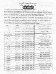
Objective Interface - Official Website of Howrah District
Objective Interface - Official Website of Howrah District
Objective Interface - Official Website of Howrah District

You also want an ePaper? Increase the reach of your titles
YUMPU automatically turns print PDFs into web optimized ePapers that Google loves.
E-Governance at <strong>Howrah</strong><br />
Future Scope <strong>of</strong> Activities<br />
As the<br />
Ultimate goal <strong>of</strong> GIS is to<br />
provide decision support in<br />
planning and development<br />
by effectively depicting<br />
information on Map along<br />
with Data .<br />
An example may be<br />
cited as follows:-<br />
Considering<br />
Health , ICDS & Eduction to<br />
be important social sectors ,<br />
important decisions may<br />
have to be taken regarding<br />
construction <strong>of</strong> New School<br />
Buildings, New Anganwadi<br />
Centres, New Health<br />
Centres following the Govt.<br />
Norms.<br />
Plotting <strong>of</strong> the<br />
informations like Outreach<br />
Camps for Health , Un-served area in relation to population and distance from Roads<br />
, Condition <strong>of</strong> roads and natural barrier can be depicted in the Map which can help in<br />
effective decision making process .<br />
To achieve the desired goals , more refinements and accuracy is being<br />
incorporated in the map, Buffers is being made in the Map to show a relative<br />
distance <strong>of</strong> a location from a Road or distance between two locations . Further<br />
finding the shortest route to reach a destination is also being incorporated .<br />
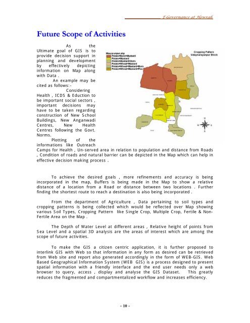
From the department <strong>of</strong> Agriculture , Data pertaining to soil types and<br />
cropping patterns is being collected which would be reflected over Map showing<br />
various Soil Types, Cropping Pattern like Single Crop, Multiple Crop, Fertile & Non-<br />
Fertile Area on the Map .<br />
The Depth <strong>of</strong> Water Level at different areas , Relative height <strong>of</strong> points from<br />
Sea Level and a spatial 3D analysis are the areas <strong>of</strong> interest which are among the<br />
scope <strong>of</strong> future activities.<br />
To make the GIS a citizen centric application, it is further proposed to<br />
interlink GIS with Web so that information in any form as desired can be retrieved<br />
from Web site and report also generated accordingly in the form <strong>of</strong> WEB-GIS. Web<br />
Based Geographical Information System (WEB GIS) is a process designed to present<br />
spatial information with a friendly interface and the end user needs only a web<br />
browser to query, access , display and analyse the GIS Dataset. This greatly<br />
reduces the fragmented and compartmentalized workflow and increases efficiency.<br />
- 10 -