Objective Interface - Official Website of Howrah District
Objective Interface - Official Website of Howrah District
Objective Interface - Official Website of Howrah District

Create successful ePaper yourself
Turn your PDF publications into a flip-book with our unique Google optimized e-Paper software.
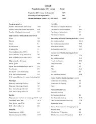
E-Governance at <strong>Howrah</strong><br />
The Outcome and Achievements<br />
In a Short span <strong>of</strong> starting the GIS activities effectively from the month <strong>of</strong><br />
March, 2007 and subsequent to the training organized to several departments ,<br />
outcome in the form <strong>of</strong> information(s) started pouring in from many departments ,<br />
naming a few are :-<br />
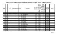
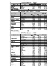
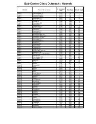
Department <strong>of</strong> Health , who have plotted a number <strong>of</strong> Information related to<br />
Parimary Health Centres , Sub-Centres , GP HQ sub Centres for many Blocks .<br />
Likewise , Department <strong>of</strong> Education had populated the Geo-Database with<br />
Primary, Upper Primary , SSK and MSK for several Blocks<br />
Department <strong>of</strong> Police had plotted vital informations like location <strong>of</strong> Police<br />
Stations, Police Outposts , Investigating Centres , Jurisdiction Areas .<br />
Department <strong>of</strong> Election had plotted information on location <strong>of</strong> Polling Stations<br />
Constituency wise.<br />
Department <strong>of</strong> Relief had identified locations <strong>of</strong> Relief Godown, Flood Shelters<br />
, Flood Affected area(s) , etc.<br />
Other Department(s) like Industry, ICDS , Transport , etc. have also<br />
contributed in populating information on the Map which could help in updating the<br />
Map with many useful informations towards a step forward for a effective GIS .<br />
Apart from the departmental<br />
activities in progress , parallel activities<br />
were also carried out at NIC, <strong>Howrah</strong> to<br />
show some more important informations<br />
on the Map based on several inputs<br />
received from various sources .<br />
Map showing Vested Water<br />
Bodies , Culturable & Non-Culturable<br />
Waterbodies- Mouzawise could be<br />
plotted through the Information received<br />
from Bureau <strong>of</strong> Applied Economics &<br />
Statistics . Land Bank Information<br />
showing Vested Land , Type <strong>of</strong> Vested<br />
Land with area could also be plotted on<br />
Culturable Waterbodies across the <strong>District</strong>,<br />
Source:- Bureau <strong>of</strong> Applied Eco & Stat<br />
the Map. Information as received from<br />
State Water Investigation Department<br />
regarding Permanent Hydrographic Stations could also be plotted on the Map.<br />
- 7 -