

PHAK - Chapter 14
PHAK - Chapter 14
PHAK - Chapter 14

You also want an ePaper? Increase the reach of your titles
YUMPU automatically turns print PDFs into web optimized ePapers that Google loves.
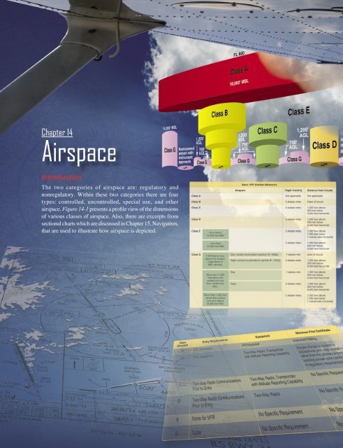
<strong>Chapter</strong> <strong>14</strong><br />
Airspace<br />
Introduction<br />
The two categories of airspace are: regulatory and<br />
nonregulatory. Within these two categories there are four<br />
types: controlled, uncontrolled, special use, and other<br />
airspace. Figure <strong>14</strong>-1 presents a profile view of the dimensions<br />
of various classes of airspace. Also, there are excerpts from<br />
sectional charts which are discussed in <strong>Chapter</strong> 15, Navigation,<br />
that are used to illustrate how airspace is depicted.<br />
<strong>14</strong>-1
FL 600<br />
Class A<br />
18,000' MSL<br />
<strong>14</strong>,500' MSL<br />
Class G<br />
Nontowered<br />
airport with<br />
instrument<br />
approach<br />
1,200'<br />
AGL<br />
700'<br />
AGL<br />
Class B<br />
1,200'<br />
AGL<br />
700'<br />
AGL<br />
Class C<br />
Class E<br />
1,200'<br />
AGL<br />
700'<br />
AGL<br />
Class G Class G Class G<br />
Class D<br />
Nontowered<br />
airport with<br />
no instrument<br />
approach<br />
Figure <strong>14</strong>-1. Airspace profile.<br />
Controlled Airspace<br />
Controlled airspace is a generic term that covers the<br />
different classifications of airspace and defined dimensions<br />
within which air traffic control (ATC) service is provided<br />
in accordance with the airspace classification. Controlled<br />
airspace consists of:<br />
• Class A<br />
• Class B<br />
• Class C<br />
• Class D<br />
• Class E<br />
Class A Airspace<br />
Class A airspace is generally the airspace from 18,000 feet<br />
mean sea level (MSL) up to and including flight level (FL)<br />
600, including the airspace overlying the waters within 12<br />
nautical miles (NM) of the coast of the 48 contiguous states<br />
and Alaska. Unless otherwise authorized, all operation in<br />
Class A airspace is conducted under instrument flight rules<br />
(IFR).<br />
Class B Airspace<br />
Class B airspace is generally airspace from the surface to<br />
10,000 feet MSL surrounding the nation’s busiest airports in<br />
terms of airport operations or passenger enplanements. The<br />
configuration of each Class B airspace area is individually<br />
tailored, consists of a surface area and two or more layers<br />
(some Class B airspace areas resemble upside-down wedding<br />
cakes), and is designed to contain all published instrument<br />
procedures once an aircraft enters the airspace. An ATC<br />
clearance is required for all aircraft to operate in the area,<br />
and all aircraft that are so cleared receive separation services<br />
within the airspace.<br />
Class C Airspace<br />
Class C airspace is generally airspace from the surface<br />
to 4,000 feet above the airport elevation (charted in<br />
MSL) surrounding those airports that have an operational<br />
control tower, are serviced by a radar approach control,<br />
and have a certain number of IFR operations or passenger<br />
enplanements. Although the configuration of each Class C<br />
area is individually tailored, the airspace usually consists of<br />
a surface area with a five NM radius, an outer circle with<br />
a ten NM radius that extends from 1,200 feet to 4,000 feet<br />
above the airport elevation, and an outer area. Each aircraft<br />
must establish two-way radio communications with the<br />
ATC facility providing air traffic services prior to entering<br />
the airspace and thereafter maintain those communications<br />
while within the airspace.<br />
Class D Airspace<br />
Class D airspace is generally airspace from the surface to<br />
2,500 feet above the airport elevation (charted in MSL)<br />
surrounding those airports that have an operational control<br />
tower. The configuration of each Class D airspace area is<br />
individually tailored and when instrument procedures are<br />
published, the airspace is normally designed to contain the<br />
procedures. Arrival extensions for instrument approach<br />
procedures (IAPs) may be Class D or Class E airspace. Unless<br />
otherwise authorized, each aircraft must establish two-way<br />
radio communications with the ATC facility providing air<br />
traffic services prior to entering the airspace and thereafter<br />
maintain those communications while in the airspace.<br />
Class E Airspace<br />
If the airspace is not Class A, B, C, or D, and is controlled<br />
airspace, then it is Class E airspace. Class E airspace extends<br />
upward from either the surface or a designated altitude to the<br />
<strong>14</strong>-2
overlying or adjacent controlled airspace. When designated<br />
as a surface area, the airspace is configured to contain all<br />
instrument procedures. Also in this class are federal airways,<br />
airspace beginning at either 700 or 1,200 feet above ground<br />
level (AGL) used to transition to and from the terminal or<br />
en route environment, and en route domestic and offshore<br />
airspace areas designated below 18,000 feet MSL. Unless<br />
designated at a lower altitude, Class E airspace begins at<br />
<strong>14</strong>,500 MSL over the United States, including that airspace<br />
overlying the waters within 12 NM of the coast of the 48<br />
contiguous states and Alaska, up to but not including 18,000<br />
feet MSL, and the airspace above FL 600.<br />
Uncontrolled Airspace<br />
Class G Airspace<br />
Uncontrolled airspace or Class G airspace is the portion of<br />
the airspace that has not been designated as Class A, B, C,<br />
D, or E. It is therefore designated uncontrolled airspace.<br />
Class G airspace extends from the surface to the base of the<br />
overlying Class E airspace. Although ATC has no authority<br />
or responsibility to control air traffic, pilots should remember<br />
there are visual flight rules (VFR) minimums which apply<br />
to Class G airspace.<br />
Special Use Airspace<br />
Special use airspace or special area of operation (SAO)<br />
is the designation for airspace in which certain activities<br />
must be confined, or where limitations may be imposed<br />
on aircraft operations that are not part of those activities.<br />
Certain special use airspace areas can create limitations on<br />
the mixed use of airspace. The special use airspace depicted<br />
on instrument charts includes the area name or number,<br />
effective altitude, time and weather conditions of operation,<br />
the controlling agency, and the chart panel location. On<br />
National Aeronautical Charting Group (NACG) en route<br />
charts, this information is available on one of the end panels.<br />
Special use airspace usually consists of:<br />
• Prohibited areas<br />
• Restricted areas<br />
• Warning areas<br />
• Military operation areas (MOAs)<br />
• Alert areas<br />
• Controlled firing areas (CFAs)<br />
charted as a “P” followed by a number (e.g., P-49). Examples<br />
of prohibited areas include Camp David and the National<br />
Mall in Washington, D.C., where the White House and the<br />
Congressional buildings are located. [Figure <strong>14</strong>-2]<br />
Figure <strong>14</strong>-2. An example of a prohibited area is Crawford, Texas.<br />
Restricted Areas<br />
Restricted areas are areas where operations are hazardous to<br />
nonparticipating aircraft and contain airspace within which<br />
the flight of aircraft, while not wholly prohibited, is subject<br />
to restrictions. Activities within these areas must be confined<br />
because of their nature, or limitations may be imposed upon<br />
aircraft operations that are not a part of those activities, or<br />
both. Restricted areas denote the existence of unusual, often<br />
invisible, hazards to aircraft (e.g., artillery firing, aerial<br />
gunnery, or guided missiles). IFR flights may be authorized<br />
to transit the airspace and are routed accordingly. Penetration<br />
of restricted areas without authorization from the using<br />
or controlling agency may be extremely hazardous to the<br />
aircraft and its occupants. ATC facilities apply the following<br />
procedures when aircraft are operating on an IFR clearance<br />
(including those cleared by ATC to maintain VFR on top) via<br />
a route which lies within joint-use restricted airspace:<br />
1. If the restricted area is not active and has been released<br />
to the Federal Aviation Administration (FAA), the<br />
ATC facility allows the aircraft to operate in the<br />
restricted airspace without issuing specific clearance<br />
for it to do so.<br />
2. If the restricted area is active and has not been released<br />
to the FAA, the ATC facility issues a clearance which<br />
ensures the aircraft avoids the restricted airspace.<br />
Prohibited Areas<br />
Prohibited areas contain airspace of defined dimensions<br />
within which the flight of aircraft is prohibited. Such areas<br />
are established for security or other reasons associated with<br />
the national welfare. These areas are published in the Federal<br />
Register and are depicted on aeronautical charts. The area is<br />
<strong>14</strong>-3
Restricted areas are charted with an “R” followed by a<br />
number (e.g., R-4401) and are depicted on the en route<br />
chart appropriate for use at the altitude or FL being flown.<br />
[Figure <strong>14</strong>-3] Restricted area information can be obtained<br />
on the back of the chart.<br />
military training activities from IFR traffic. Whenever an<br />
MOA is being used, nonparticipating IFR traffic may be<br />
cleared through an MOA if IFR separation can be provided by<br />
ATC. Otherwise, ATC reroutes or restricts nonparticipating<br />
IFR traffic. MOAs are depicted on sectional, VFR terminal<br />
area, and en route low altitude charts and are not numbered<br />
(e.g., “Camden Ridge MOA”). [Figure <strong>14</strong>-5] However, the<br />
MOA is also further defined on the back of the sectional<br />
charts with times of operation, altitudes affected, and the<br />
controlling agency.<br />
Alert Areas<br />
Alert areas are depicted on aeronautical charts with an “A”<br />
followed by a number (e.g., A-211) to inform nonparticipating<br />
pilots of areas that may contain a high volume of pilot training<br />
or an unusual type of aerial activity. Pilots should exercise<br />
caution in alert areas. All activity within an alert area shall<br />
be conducted in accordance with regulations, without waiver,<br />
and pilots of participating aircraft, as well as pilots transiting<br />
the area, shall be equally responsible for collision avoidance.<br />
[Figure <strong>14</strong>-6]<br />
Figure <strong>14</strong>-3. Restricted areas on a sectional chart.<br />
Warning Areas<br />
Warning areas are similar in nature to restricted areas;<br />
however, the United States government does not have sole<br />
jurisdiction over the airspace. A warning area is airspace of<br />
defined dimensions, extending from 12 NM outward from<br />
the coast of the United States, containing activity that may<br />
be hazardous to nonparticipating aircraft. The purpose of<br />
such areas is to warn nonparticipating pilots of the potential<br />
danger. A warning area may be located over domestic or<br />
international waters or both. The airspace is designated with<br />
a “W” followed by a number (e.g., W-237). [Figure <strong>14</strong>-4]<br />
Military Operation Areas (MOAs)<br />
MOAs consist of airspace with defined vertical and lateral<br />
limits established for the purpose of separating certain<br />
Figure <strong>14</strong>-4. Requirements for airspace operations.<br />
Controlled Firing Areas (CFAs)<br />
CFAs contain activities, which, if not conducted in a controlled<br />
environment, could be hazardous to nonparticipating aircraft.<br />
The difference between CFAs and other special use airspace<br />
is that activities must be suspended when a spotter aircraft,<br />
radar, or ground lookout position indicates an aircraft might<br />
be approaching the area. There is no need to chart CFAs<br />
since they do not cause a nonparticipating aircraft to change<br />
its flightpath.<br />
Other Airspace Areas<br />
“Other airspace areas” is a general term referring to the<br />
majority of the remaining airspace. It includes:<br />
• Local airport advisory<br />
• Military training route (MTR)<br />
• Temporary flight restriction (TFR)<br />
• Parachute jump aircraft operations<br />
• Published VFR routes<br />
• Terminal radar service area (TRSA)<br />
• National security area (NSA)<br />
Local Airport Advisory (LAA)<br />
A service provided by facilities, which are located on the<br />
landing airport, have a discrete ground-to-air communication<br />
frequency or the tower frequency when the tower is closed,<br />
automated weather reporting with voice broadcasting, and<br />
a continuous ASOS/AWOS data display, other continuous<br />
direct reading instruments, or manual observations available<br />
to the specialist.<br />
<strong>14</strong>-4
Figure <strong>14</strong>-5. Camden Ridge MOA is an example of a military operations area.<br />
Figure <strong>14</strong>-6. Alert area (A-211).<br />
<strong>14</strong>-5
Military Training Routes (MTRs)<br />
MTRs are routes used by military aircraft to maintain<br />
proficiency in tactical flying. These routes are usually<br />
established below 10,000 feet MSL for operations at speeds<br />
in excess of 250 knots. Some route segments may be defined<br />
at higher altitudes for purposes of route continuity. Routes are<br />
identified as IFR (IR), and VFR (VR), followed by a number.<br />
[Figure <strong>14</strong>-7] MTRs with no segment above 1,500 feet<br />
AGL are identified by four number characters (e.g., IR1206,<br />
VR1207). MTRs that include one or more segments above<br />
1,500 feet AGL are identified by three number characters<br />
(e.g., IR206, VR207). IFR low altitude en route charts<br />
depict all IR routes and all VR routes that accommodate<br />
operations above 1,500 feet AGL. IR routes are conducted<br />
in accordance with IFR regardless of weather conditions.<br />
VFR sectional charts depict military training activities such<br />
as IR, VR, MOA, restricted area, warning area, and alert<br />
area information.<br />
• Protect declared national disasters for humanitarian<br />
reasons in the State of Hawaii.<br />
• Protect the President, Vice President, or other public<br />
figures.<br />
• Provide a safe environment for space agency<br />
operations.<br />
Since the events of September 11, 2001, the use of TFRs has<br />
become much more common. There have been a number<br />
of incidents of aircraft incursions into TFRs, which have<br />
resulted in pilots undergoing security investigations and<br />
certificate suspensions. It is a pilot’s responsibility to be<br />
aware of TFRs in their proposed area of flight. One way to<br />
check is to visit the FAA website, www.tfr.faa.gov, and verify<br />
that there is not a TFR in the area.<br />
Parachute Jump Aircraft Operations<br />
Parachute jump aircraft operations are published in the<br />
Airport/Facility Directory (A/FD). Sites that are used<br />
frequently are depicted on sectional charts.<br />
Published VFR Routes<br />
Published VFR routes are for transitioning around, under, or<br />
through some complex airspace. Terms such as VFR flyway,<br />
VFR corridor, Class B airspace VFR transition route, and<br />
terminal area VFR route have been applied to such routes.<br />
These routes are generally found on VFR terminal area<br />
planning charts.<br />
Figure <strong>14</strong>-7. Military training route (MTR) chart symbols.<br />
Temporary Flight Restrictions (TFR)<br />
A flight data center (FDC) Notice to Airmen (NOTAM)<br />
is issued to designate a TFR. The NOTAM begins with<br />
the phrase “FLIGHT RESTRICTIONS” followed by the<br />
location of the temporary restriction, effective time period,<br />
area defined in statute miles, and altitudes affected. The<br />
NOTAM also contains the FAA coordination facility and<br />
telephone number, the reason for the restriction, and any other<br />
information deemed appropriate. The pilot should check the<br />
NOTAMs as part of flight planning.<br />
Some of the purposes for establishing a TFR are:<br />
• Protect persons and property in the air or on the surface<br />
from an existing or imminent hazard.<br />
• Provide a safe environment for the operation of<br />
disaster relief aircraft.<br />
• Prevent an unsafe congestion of sightseeing aircraft<br />
above an incident or event, which may generate a high<br />
degree of public interest.<br />
Terminal Radar Service Areas (TRSAs)<br />
TRSAs are areas where participating pilots can receive<br />
additional radar services. The purpose of the service is<br />
to provide separation between all IFR operations and<br />
participating VFR aircraft.<br />
The primary airport(s) within the TRSA become(s) Class D<br />
airspace. The remaining portion of the TRSA overlies other<br />
controlled airspace, which is normally Class E airspace<br />
beginning at 700 or 1,200 feet and established to transition to/<br />
from the en route/terminal environment. TRSAs are depicted<br />
on VFR sectional charts and terminal area charts with a solid<br />
black line and altitudes for each segment. The Class D portion<br />
is charted with a blue segmented line. Participation in TRSA<br />
services is voluntary; however, pilots operating under VFR<br />
are encouraged to contact the radar approach control and take<br />
advantage of TRSA service.<br />
National Security Areas (NSAs)<br />
NSAs consist of airspace of defined vertical and lateral<br />
dimensions established at locations where there is a<br />
requirement for increased security and safety of ground<br />
facilities. Flight in NSAs may be temporarily prohibited by<br />
<strong>14</strong>-6
egulation under the provisions of Title <strong>14</strong> of the Code of<br />
Federal Regulations (<strong>14</strong> CFR) part 99, and prohibitions are<br />
disseminated via NOTAM. Pilots are requested to voluntarily<br />
avoid flying through these depicted areas.<br />
Air Traffic Control and the National<br />
Airspace System<br />
The primary purpose of the ATC system is to prevent a<br />
collision between aircraft operating in the system and to<br />
organize and expedite the flow of traffic. In addition to<br />
its primary function, the ATC system has the capability to<br />
provide (with certain limitations) additional services. The<br />
ability to provide additional services is limited by many<br />
factors, such as the volume of traffic, frequency congestion,<br />
quality of radar, controller workload, higher priority duties,<br />
and the pure physical inability to scan and detect those<br />
situations that fall in this category. It is recognized that these<br />
services cannot be provided in cases in which the provision<br />
of services is precluded by the above factors.<br />
Consistent with the aforementioned conditions, controllers<br />
shall provide additional service procedures to the extent<br />
permitted by higher priority duties and other circumstances.<br />
The provision of additional services is not optional on the<br />
part of the controller, but rather is required when the work<br />
situation permits. Provide ATC service in accordance with<br />
the procedures and minima in this order except when:<br />
1. A deviation is necessary to conform with ICAO<br />
Documents, National Rules of the Air, or special<br />
agreements where the United States provides ATC<br />
service in airspace outside the country and its<br />
possessions or:<br />
2. Other procedures/minima are prescribed in a letter of<br />
agreement, FAA directive, or a military document,<br />
or:<br />
3. A deviation is necessary to assist an aircraft when an<br />
emergency has been declared.<br />
Coordinating the Use of Airspace<br />
ATC is responsible for ensuring that the necessary<br />
coordination has been accomplished before allowing an<br />
aircraft under their control to enter another controller’s area<br />
of jurisdiction.<br />
Before issuing control instructions directly or relaying<br />
through another source to an aircraft which is within<br />
another controller’s area of jurisdiction that will change that<br />
aircraft’s heading, route, speed, or altitude, ATC ensures<br />
that coordination has been accomplished with each of the<br />
controllers listed below whose area of jurisdiction is affected<br />
by those instructions unless otherwise specified by a letter<br />
of agreement or a facility directive:<br />
1. The controller within whose area of jurisdiction the<br />
control instructions are issued.<br />
2. The controller receiving the transfer of control.<br />
3. Any intervening controller(s) through whose area of<br />
jurisdiction the aircraft will pass.<br />
If ATC issues control instructions to an aircraft through a<br />
source other than another controller (e.g., Aeronautical Radio,<br />
Incorporated (ARINC), Automated Flight Service Station/<br />
Flight Service Station (AFSS/FSS), another pilot) they ensure<br />
that the necessary coordination has been accomplished with<br />
any controllers listed above, whose area of jurisdiction is<br />
affected by those instructions unless otherwise specified by<br />
a letter of agreement or a facility directive.<br />
Operating in the Various Types of Airspace<br />
It is important that pilots be familiar with the operational<br />
requirements for each of the various types or classes of<br />
airspace. Subsequent sections cover each class in sufficient<br />
detail to facilitate understanding with regard to weather, type<br />
of pilot certificate held, as well as equipment required.<br />
Basic VFR Weather Minimums<br />
No pilot may operate an aircraft under basic VFR when the<br />
flight visibility is less, or at a distance from clouds that is<br />
less, than that prescribed for the corresponding altitude and<br />
class of airspace. [Figure <strong>14</strong>-9] Except as provided in <strong>14</strong><br />
CFR Section 91.157, Special VFR Weather Minimums, no<br />
person may operate an aircraft beneath the ceiling under<br />
VFR within the lateral boundaries of controlled airspace<br />
designated to the surface for an airport when the ceiling is<br />
less than 1,000 feet. Additional information can be found in<br />
<strong>14</strong> CFR section 91.155(c).<br />
Operating Rules and Pilot/Equipment Requirements<br />
The safety of flight is a top priority of all pilots and the<br />
responsibilities associated with operating an aircraft<br />
should always be taken seriously. The air traffic system<br />
maintains a high degree of safety and efficiency with strict<br />
regulatory oversight of the FAA. Pilots fly in accordance<br />
with regulations that have served the United States well, as<br />
evidenced by the fact that the country has the safest aviation<br />
system in the world.<br />
All aircraft operating in today’s National Airspace System<br />
(NAS) has complied with the CFR governing its certification<br />
and maintenance; all pilots operating today have completed<br />
rigorous pilot certification training and testing. Of equal<br />
importance is the proper execution of preflight planning,<br />
aeronautical decision-making (ADM) and risk management.<br />
ADM involves a systematic approach to risk assessment<br />
and stress management in aviation, illustrates how personal<br />
<strong>14</strong>-7
attitudes can influence decision-making, and how those<br />
attitudes can be modified to enhance safety in the flight<br />
deck. More detailed information regarding ADM and<br />
risk mitigation can be found in <strong>Chapter</strong> 17, Aeronautical<br />
Decision-Making.<br />
Pilots also comply with very strict FAA general operating<br />
and flight rules as outlined in the CFR, including the FAA’s<br />
important “see and avoid” mandate. These regulations<br />
provide the historical foundation of the FAA regulations<br />
governing the aviation system and the individual classes of<br />
airspace. Figure <strong>14</strong>-10 lists the operational and equipment<br />
requirements for these various classes of airspace. It will<br />
be helpful to refer to this figure as the specific classes are<br />
discussed in greater detail.<br />
received prior to entering the airspace. Unless otherwise<br />
authorized by ATC, each aircraft operating in Class A<br />
airspace must be equipped with a two-way radio capable of<br />
communicating with ATC on a frequency assigned by ATC.<br />
Unless otherwise authorized by ATC, all aircraft within Class<br />
A airspace must be equipped with the appropriate transponder<br />
equipment meeting all applicable specifications found in <strong>14</strong><br />
CFR section 91.215.<br />
Class B<br />
All pilots operating an aircraft within a Class B airspace area<br />
must receive an ATC clearance from the ATC facility having<br />
jurisdiction for that area. The pilot in command (PIC) may<br />
not take off or land an aircraft at an airport within a Class<br />
B airspace unless he or she has met one of the following<br />
requirements:<br />
Class A<br />
1. A private pilot certificate.<br />
Pilots operating an aircraft in Class A airspace must conduct<br />
that operation under IFR and only under an ATC clearance 2. A recreational pilot certificate and all requirements<br />
Basic VFR Weather Minimums contained within <strong>14</strong> CFR section 61.101(d), or the<br />
Airspace<br />
Flight Visibility<br />
Distance from Clouds<br />
Class A Not applicable Not applicable<br />
Class B 3 statute miles Clear of clouds<br />
Class C 3 statute miles 1,000 feet above<br />
500 feet below<br />
2,000 feet horizontal<br />
Class D 3 statute miles 1,000 feet above<br />
500 feet below<br />
2,000 feet horizontal<br />
Class E 5 statute miles 1,000 feet above<br />
At or above<br />
1,000 feet below<br />
10,000 feet MSL<br />
1 statute mile horizontal<br />
Less than<br />
10,000 feet MSL<br />
3 statute miles 1,000 feet above<br />
500 feet below<br />
2,000 feet horizontal<br />
Class G Day, except as provided in section 91.155(b) 1 statute mile Clear of clouds<br />
1,200 feet or less<br />
above the surface<br />
Night, except as provided in section 91.155(b) 3 statute miles 1,000 feet above<br />
(regardless of<br />
500 feet below<br />
MSL altitude).<br />
2,000 feet horizontal<br />
More than 1,200<br />
feet above the<br />
surface but less<br />
than 10,000 feet<br />
MSL.<br />
More than 1,200 feet<br />
above the surface<br />
and at or above<br />
10,000 feet MSL.<br />
Day 1 statute mile 1,000 feet above<br />
500 feet below<br />
2,000 feet horizontal<br />
Night 3 statute miles 1,000 feet above<br />
500 feet below<br />
2,000 feet horizontal<br />
5 statute miles 1,000 feet above<br />
1,000 feet below<br />
1 statute mile horizontal<br />
Figure <strong>14</strong>-9. Visual flight rule weather minimums.<br />
<strong>14</strong>-8
equirements for a student pilot seeking a recreational<br />
pilot certificate in <strong>14</strong> CFR section 61.94.<br />
3. A sport pilot certificate and all requirements contained<br />
within <strong>14</strong> CFR section 61.325, or the requirements for<br />
a student pilot seeking a recreational pilot certificate<br />
in <strong>14</strong> CFR section 61.94, or the aircraft is operated<br />
by a student pilot who has met the requirements of <strong>14</strong><br />
CFR sections 61.94 and 61.95, as applicable.<br />
Unless otherwise authorized by ATC, all aircraft within Class<br />
B airspace must be equipped with the applicable operating<br />
transponder and automatic altitude reporting equipment<br />
specified in <strong>14</strong> CFR section 91.215(a) and an operable<br />
two-way radio capable of communications with ATC on<br />
appropriate frequencies for that Class B airspace area.<br />
Class C<br />
For the purpose of this section, the primary airport is the<br />
airport for which the Class C airspace area is designated. A<br />
satellite airport is any other airport within the Class C airspace<br />
area. No pilot may take off or land an aircraft at a satellite<br />
airport within a Class C airspace area except in compliance<br />
with FAA arrival and departure traffic patterns.<br />
Two-way radio communications must be established and<br />
maintained with the ATC facility providing air traffic services<br />
prior to entering the airspace and thereafter maintained while<br />
within the airspace.<br />
A pilot departing from the primary airport or satellite airport<br />
with an operating control tower must establish and maintain<br />
two-way radio communications with the control tower,<br />
and thereafter as instructed by ATC while operating in the<br />
Class C airspace area. If departing from a satellite airport<br />
without an operating control tower, the pilot must establish<br />
and maintain two-way radio communications with the ATC<br />
facility having jurisdiction over the Class C airspace area as<br />
soon as practicable after departing.<br />
Unless otherwise authorized by the ATC having jurisdiction<br />
over the Class C airspace area, all aircraft within Class C<br />
airspace must be equipped with the appropriate transponder<br />
equipment meeting all applicable specifications found in <strong>14</strong><br />
CFR section 91.215.<br />
Class D<br />
No pilot may take off or land an aircraft at a satellite airport<br />
within a Class D airspace area except in compliance with<br />
FAA arrival and departure traffic patterns. A pilot departing<br />
from the primary airport or satellite airport with an operating<br />
control tower must establish and maintain two-way radio<br />
communications with the control tower, and thereafter as<br />
instructed by ATC while operating in the Class D airspace<br />
area. If departing from a satellite airport without an operating<br />
control tower, the pilot must establish and maintain twoway<br />
radio communications with the ATC facility having<br />
jurisdiction over the Class D airspace area as soon as<br />
practicable after departing.<br />
Two-way radio communications must be established and<br />
maintained with the ATC facility providing air traffic services<br />
prior to entering the airspace and thereafter maintained while<br />
within the airspace.<br />
If the aircraft radio fails in flight under IFR, the pilot<br />
should continue the flight by the route assigned in the last<br />
ATC clearance received; or, if being radar vectored, by the<br />
direct route from the point of radio failure to the fix, route,<br />
or airway specified in the vector clearance. In the absence<br />
of an assigned route, the pilot should continue by the route<br />
Class<br />
Airspace<br />
Entry Requirements<br />
Equipment<br />
Minimum Pilot Certificate<br />
A<br />
ATC clearance<br />
IFR equipped<br />
Instrument rating<br />
B<br />
ATC clearance<br />
Two-way radio, transponder<br />
with altitude reporting capability<br />
Private—(However, a student or<br />
recreational pilot may operate at<br />
other than the primary airport if<br />
seeking private pilot certification and<br />
if regulatory requirements are met.)<br />
C<br />
Two-way radio communications<br />
prior to entry<br />
Two-way radio, transponder<br />
with altitude reporting capability<br />
No specific requirement<br />
D<br />
Two-way radio communications<br />
prior to entry<br />
Two-way radio<br />
No specific requirement<br />
E<br />
None for VFR<br />
No specific requirement<br />
No specific requirement<br />
G<br />
None<br />
No specific requirement<br />
No specific requirement<br />
Figure <strong>14</strong>-10. Requirements for airspace operations.<br />
<strong>14</strong>-9
that ATC advised may be expected in a further clearance;<br />
or, if a route had not been advised, by the route filed in the<br />
flight plan.<br />
If the aircraft radio fails in flight under VFR, the PIC may<br />
operate that aircraft and land if weather conditions are at or<br />
above basic VFR weather minimums, visual contact with the<br />
tower is maintained, and a clearance to land is received.<br />
Class E<br />
Unless otherwise required by <strong>14</strong> CFR part 93 or unless<br />
otherwise authorized or required by the ATC facility having<br />
jurisdiction over the Class E airspace area, each pilot<br />
operating an aircraft on or in the vicinity of an airport in a<br />
Class E airspace area must comply with the requirements of<br />
Class G airspace. Each pilot must also comply with any traffic<br />
patterns established for that airport in <strong>14</strong> CFR part 93.<br />
Unless otherwise authorized or required by ATC, no person<br />
may operate an aircraft to, from, through, or on an airport<br />
having an operational control tower unless two-way radio<br />
communications are maintained between that aircraft and<br />
the control tower. Communications must be established prior<br />
to four nautical miles from the airport, up to and including<br />
2,500 feet AGL. However, if the aircraft radio fails in<br />
flight, the PIC may operate that aircraft and land if weather<br />
conditions are at or above basic VFR weather minimums,<br />
visual contact with the tower is maintained, and a clearance<br />
to land is received.<br />
If the aircraft radio fails in flight under IFR, the pilot<br />
should continue the flight by the route assigned in the last<br />
ATC clearance received; or, if being radar vectored, by the<br />
direct route from the point of radio failure to the fix, route,<br />
or airway specified in the vector clearance. In the absence<br />
of an assigned route, the pilot should continue by the route<br />
that ATC advised may be expected in a further clearance;<br />
or, if a route had not been advised, by the route filed in the<br />
flight plan.<br />
Class G<br />
When approaching to land at an airport without an operating<br />
control tower in Class G airspace:<br />
1. Each pilot of an airplane must make all turns of that<br />
airplane to the left unless the airport displays approved<br />
light signals or visual markings indicating that turns<br />
should be made to the right, in which case the pilot<br />
must make all turns to the right.<br />
2. Each pilot of a helicopter or a powered parachute must<br />
avoid the flow of fixed-wing aircraft.<br />
Unless otherwise authorized or required by ATC, no person<br />
may operate an aircraft to, from, through, or on an airport<br />
having an operational control tower unless two-way radio<br />
communications are maintained between that aircraft and the<br />
control tower. Communications must be established prior to<br />
four nautical miles from the airport, up to and including 2,500<br />
feet AGL. However, if the aircraft radio fails in flight, the<br />
pilot in command may operate that aircraft and land if weather<br />
conditions are at or above basic VFR weather minimums,<br />
visual contact with the tower is maintained, and a clearance<br />
to land is received.<br />
If the aircraft radio fails in flight under IFR, the pilot<br />
should continue the flight by the route assigned in the last<br />
ATC clearance received; or, if being radar vectored, by the<br />
direct route from the point of radio failure to the fix, route,<br />
or airway specified in the vector clearance. In the absence<br />
of an assigned route, the pilot should continue by the route<br />
that ATC advised may be expected in a further clearance;<br />
or, if a route had not been advised, by the route filed in the<br />
flight plan.<br />
Ultralight Vehicles<br />
No person may operate an ultralight vehicle within Class A,<br />
Class B, Class C, or Class D airspace or within the lateral<br />
boundaries of the surface area of Class E airspace designated<br />
for an airport unless that person has prior authorization from<br />
the ATC facility having jurisdiction over that airspace. (See<br />
<strong>14</strong> CFR part 103.)<br />
Unmanned Free Balloons<br />
Unless otherwise authorized by ATC, no person may operate<br />
an unmanned free balloon below 2,000 feet above the surface<br />
within the lateral boundaries of Class B, Class C, Class D,<br />
or Class E airspace designated for an airport. (See <strong>14</strong> CFR<br />
part 101.)<br />
Parachute Jumps<br />
No person may make a parachute jump, and no PIC may<br />
allow a parachute jump to be made from that aircraft, in or<br />
into Class A, Class B, Class C, or Class D airspace without,<br />
or in violation of, the terms of an ATC authorization issued<br />
by the ATC facility having jurisdiction over the airspace.<br />
(See <strong>14</strong> CFR part 105.)<br />
<strong>Chapter</strong> Summary<br />
This chapter introduces the various classifications of airspace<br />
and provides information on the requirements to operate in<br />
such airspace. For further information, consult the AIM and<br />
<strong>14</strong> CFR parts 71, 73, and 91.<br />
<strong>14</strong>-10