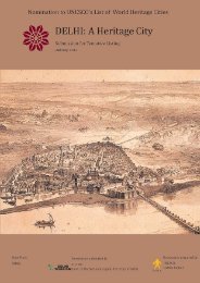
Executive Summary - Delhi Heritage City
Executive Summary - Delhi Heritage City
Executive Summary - Delhi Heritage City

You also want an ePaper? Increase the reach of your titles
YUMPU automatically turns print PDFs into web optimized ePapers that Google loves.
IMPERIAL CITIES OF DELHI<br />
AN EXECUTIVE SUMMARY<br />
STATE PARTY: INDIA<br />
Submission prepared by:<br />
Name:<br />
Indian National Trust for Art<br />
and Cultural <strong>Heritage</strong>, <strong>Delhi</strong> Chapter<br />
E-mail:delhiheritagecity@gmail.com<br />
on behalf of the <strong>Delhi</strong> Transport and Tourism Department,<br />
Government of the National Capital Territory of <strong>Delhi</strong><br />
Address: 71, Lodhi Estate, New <strong>Delhi</strong> 110 003, India Fax: + 91 11 246 11290<br />
Institution: Indian National Trust for Art and Cultural <strong>Heritage</strong> Telephone: + 91 11 246 92774<br />
Name of Property:<br />
State, Province or Region:<br />
Id no Name of the Region(s)/Districts<br />
component part<br />
001 Shahjahanabad National Capital<br />
Territory of <strong>Delhi</strong><br />
002 New <strong>Delhi</strong> National Capital<br />
Territory of <strong>Delhi</strong><br />
Imperial Cities of <strong>Delhi</strong><br />
<strong>Delhi</strong><br />
Coordinates of the<br />
Central Point<br />
Area of nominated<br />
component<br />
Area of the Buffer<br />
Zone(ha)<br />
28°39’N &<br />
673.27 ha 2,006.23 ha<br />
77° 14’E<br />
28°37’N &<br />
1,967.45 ha<br />
77° 13’E<br />
Total Area (in hectares) 2,640.72 ha 2,006.23 ha<br />
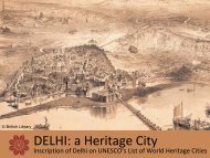
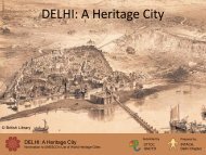
“Imperial Cities of <strong>Delhi</strong>”, a serial nomination comprising of two components, Shahjahanabad and the part of<br />
New <strong>Delhi</strong> built by the colonial government, is being proposed for inscription to UNESCO’s List of World<br />
<strong>Heritage</strong> Cities, under the category of Inhabited Historic Towns.<br />
Description<br />
Historical Reference: <strong>Delhi</strong> has been inhabited from the Stone-ages. As a site for settlements, <strong>Delhi</strong> possesses<br />
natural advantages such as the presence of the perennial River Yamuna and the ridge of hills for the supply of<br />
stones for construction; both these geographic features acted as buffers in times of war. It has a very rich<br />
agricultural hinterland to feed a large urban population, which is still considered the ‘granary of India’. Its<br />
regional importance stems from its crucial location on the important trade route, the Uttarapatha, which ran<br />
along the Gangetic plain to the Silk Route.<br />
Over the centuries, various settlements came up in the triangular area formed by the River Yamuna and the<br />
Ridge. Archaeological findings have revealed pottery fragments that date from approximately 1000-500 BC and<br />
continuous evidence of habitation from 3 rd -4 th C BC to the present. Rulers of successive dynasties from the 10 th<br />
century AD who conquered <strong>Delhi</strong> built their capitals within this triangular area of <strong>Delhi</strong>, each with their distinct<br />
fort walls and settlements, thus creating over time its various cities. Of significance in this process of city<br />
building is the fact that these cities were built adjacent to each other instead of over one another as it is<br />
commonly encountered to form historical layering.<br />
As early as the thirteenth century, the idea of <strong>Delhi</strong> was internalized by its citizens and poets , who referred to it<br />
as Hazrat-i-Dehli (revered <strong>Delhi</strong>) or the Shahr (the <strong>City</strong>). Lal Kot, the 1st city of <strong>Delhi</strong> was founded by the Tomar<br />
dynasty in 1060 AD. The Chauhans replaced the Tomars in the mid-12th century and enlarged Lal Kot to form<br />
Qila Rai Pithora. Thereafter, successive Muslim rulers conquered India and made <strong>Delhi</strong> their capital. In 1192<br />
AD, the first city was further expanded to form Mehrauli. During the <strong>Delhi</strong> Sultanate, Siri, the 2nd city of <strong>Delhi</strong>
An <strong>Executive</strong> <strong>Summary</strong><br />
Imperial Cities of <strong>Delhi</strong><br />
was established. Ghiyasuddin Tughlaq (ruled from 1320-24 AD), the first of the Tughlaq kings who followed the<br />
Khaljis, built Tughlaqabad, the 3rd city of <strong>Delhi</strong>. Muhammad-bin-Tughlaq linked the older cities of Lal Kot and<br />
Siri with two walls, from AD 1326-27, to build Jahanpanah, the 4th city of <strong>Delhi</strong>. Firoz Shah Tughlaq(1351-1388<br />
AD) built Firozabad, the 5th city of <strong>Delhi</strong>, on the banks of the river Yamuna. Unlike the other dynasties who<br />
ruled from <strong>Delhi</strong>, the Sayyid and Lodi Dynasties (up to mid 15th century AD) did not leave behind any particular<br />
city. The Mughal Emperor Humayun, in AD 1533, built Dinpanah, the 6th city of <strong>Delhi</strong>. After an interregnum, in<br />
AD 1639, Shahjahan shifted the Mughal capital back to <strong>Delhi</strong> and the walled city of Shahjahanabad, the 7th city<br />
of <strong>Delhi</strong> was built. Intermittently thereafter, it remained the capital of the Mughal Empire until 1857 when the<br />
British government took control of the country and ruled from Calcutta. In 1911 the British government shifted<br />
the capital of their empire back to <strong>Delhi</strong> and built New <strong>Delhi</strong>, the 8 th city of <strong>Delhi</strong>, to the south west of<br />
Shahjahanabad, with a buffer in between; it was inaugurated in 1931. Rarely can there be found anywhere in<br />
the world, a conglomeration of so many contiguous historic cities. Two of them, Shahjahanabad and the British<br />
built New <strong>Delhi</strong>, are being identified and nominated as the Imperial Cities of <strong>Delhi</strong>.<br />
Description of the area proposed for Nomination<br />
The two settlements proposed for nomination as ‘The Imperial Cities of <strong>Delhi</strong>’ are both outstanding examples of<br />
town planning of their time,<br />
o Shahjahanabad , the capital city of the Mughal Empire was established by the Mughal Emperor<br />
Shahjahan in the mid 17th century AD as an imperial gesture, it is considered the apogee of townplanning<br />
in medieval India; and ,<br />
o New <strong>Delhi</strong>, planned in 1912-13, and inaugurated in 1931, as the capital of the erstwhile British Empire<br />
in India, is evidence of the extraordinary fusion of two dominant themes of the early twentieth century<br />
city planning- the <strong>City</strong> Beautiful (vistas) and the Garden city (verdure) Movements.<br />
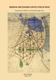
Although the two imperial cities are today engulfed within what is now termed as the National Capital Territory<br />
of <strong>Delhi</strong> (NCTD), the original urban morphology of each remains intact. Together, the nominated area is 2,640ha<br />
out of the total area of 1483 square kilometers of NCTD. The original extent of the imperial city of<br />
Shahjahanabad as built during the Mughal period forms the core area of the nominated area of Imperial<br />
Shahjahanabad and the core area of the nominated area of Imperial New <strong>Delhi</strong> is the area as originally<br />
designed by Sir Edwin Lutyens.<br />
Shahjahanabad<br />
The location of the walled city of Shahjahanabad, on high land on the western bank of the River Yamuna, was a<br />
point of convergence of important land routes of the region. The city was encircled by an 8 kilometer long wall,<br />
pierced by a number of gates. The largest and grandest structure within the city was the palace citadel, Qila-i-<br />
Mubarak (Red Fort), built along the river Yamuna to accommodate the imperial court and household. Chandni<br />
Chowk, a ceremonial pathway about 1.6 kilometres long, constitutes the east - west ceremonial axis,<br />
connecting the Qila-i-Mubarak in the east to the Fatehpuri Masjid in the west. Important public buildings and<br />
commercial establishments were located along this ceremonial axis, among them the kotwali(main police<br />
station), Sunehri Masjid, a mosque built in 1721-22 This ceremonial street was divided into three sections by<br />
two historic chowks. The one nearest to the fort was originally called Kotwali Chowk, but is today known<br />
popularly as Phawwara chowk after the phawwara or fountain, built here in the 1870s. The one inbetween the<br />
Kotwali Chowl and Fatehpuri Masjid was known as Chandni Chowk. The area north of Chandni Chowk had a<br />
large private royal garden and large estates of the nobility.<br />
Another major focal point in the walled city is Jama Masjid, the most impressive structure in Shahjahanabad<br />
besides the Red Fort. It is still the largest mosque in India, and was patronised by the emperor himself. It<br />
continues to serve as the main congregational mosque of the city and can hold up to 25,000 people<br />
Faiz Bazaar, an important commercial street, links the <strong>Delhi</strong> Gate of the palace to the <strong>Delhi</strong> Gate of the walled<br />
city. In later years, this became the principal north-south route through the city connecting Civil Lines to the<br />
north of Shahjahanabad and New <strong>Delhi</strong> to its south. To the east of this street lies Daryaganj, literally ‘the mart<br />
2
An <strong>Executive</strong> <strong>Summary</strong><br />
Imperial Cities of <strong>Delhi</strong><br />
by the river’. Another important node of the imperial city was Chowk Qasi Hauz, the main water reservoir,<br />
situated at the junction of four important bazaars. Today, the chowk remains as an important node, but it is no<br />
longer a water reservoir. These elements, each connected to one of the city gates, dictated the street pattern<br />
and spatial distribution of the population.<br />
A basic network of five major arterials leading from the city gates to Fatehpuri Masjid, Qasi Hauz, Jama Masjid<br />
and Kalan Masjid were built as spines of major commercial activity. Other landmarks like mosques, temples,<br />
gurudwaras and later, churches, were built organically in the interstices of the main arteries. The junction or<br />
crossing of two streets forms a ‘chowk’. Other streets of a lower hierarchy are access roads to residential areas.<br />
This network created social areas or neighbourhoods, known as mohallas, katras and kuchas. Essentially, these<br />
settlements came up in the quadrant bounded by Chandni Chowk, Faiz Bazaar, and the city wall. The residences<br />
were of courtyard typology and the neighbourhoods they formed were introverted precincts with independent<br />
social and functional use and character.<br />
As the capital of a rich empire and an important centre of trade, Shahjahanabad had the most famous specialist<br />
markets. Some that exist till today include Dariba Kalan, the gold and silver ware market; Kinari bazaar, the gilt<br />
and sequin market; Khari Baoli, the spice market; Katra Neel, the fabrics market and many more.<br />
As the premier trade and cultural centre, the architecture of the buildings in this imperial city displayed a<br />
synthesis of styles which were the products of an exchange of cultural meaning across sectarian lines. The lotus<br />
and kalash, held sacred by the Hindu tradition, became a part of the mosques and tombs of the city and the<br />
Hindu and Jain temples of Shahjahanabad used the cusped arches and fluted domes of the mature Mughal<br />
style. The buildings therefore represent a style that is neither ‘Hindu’ nor ‘Muslim’, irrespective of whether or<br />
not the function of a particular building was a religious one. They consciously sought to incorporate meaningful<br />
elements from different traditions. This syncretism is a characteristic of universal significance and can be seen<br />
in historic buildings throughout Shahjahanabad.<br />
The decline of the Mughal rule was followed by increasing influence of British colonial control of the city, which<br />
resulted in a process of change. Commercial and residential sectors increased in density to cater to an<br />
expanding colonial empire. However, the traditional urban morphology of the city did not change.<br />
New <strong>Delhi</strong><br />
The city designed by Sir Edward Lutyens , redefined the architecture and urbanism of <strong>Delhi</strong> and in the process<br />
introduced a modern idiom to this ancient city. At its core of Imperial New <strong>Delhi</strong> is the grand processional<br />
avenue, Kingsway, now known as Rajpath. Like Chandni Chowk, it is also aligned east-west and links two<br />
important elements of the city, the Viceroy’s House, now known as Rashtrapati Bhawan and the Capitol<br />
Complex, and the India Gate, located in a hexagonal park flanked by the residences of native rulers. Along with<br />
the network of diagonal tree lined avenues, which have been carefully graded in order of functional importance,<br />
it creates the most iconic image of the former Imperial Capital fusing, for the first time anywhere in the world,<br />
the two dominant themes of early twentieth century city planning – the <strong>City</strong> Beautiful (vistas) and the Garden<br />
<strong>City</strong> (verdure) Movements. The main cross axis, Queensway, now Janpath, runs south from the business<br />
district, Connaught Place. This morphology still palpably exists.<br />
In the architecture of the buildings, Indian elements and motifs were used, drawing inspiration from Buddhist<br />
religious complexes on the one hand, and grand Mughal buildings and the humble indigenous bungalow on the<br />
other. The overwhelming aesthetic strategy captures the spirit of syncretism evident in <strong>Delhi</strong> for many<br />
centuries, in this case a synthesis of Western classical geometry and Indian motifs.<br />
No buffer zone has been designated for Shahjahanabad as the layout is inward looking, not requiring a setting<br />
beyond the city walls for it to retain its integrity. However, a buffer has been retained towards the Yamuna as the<br />
original concept was a city along the banks of the river. The River Yamuna has changed course over the years<br />
moving away from the city wall. The space thus created has been retained as a buffer in order to retain the<br />
memory of a city along the river.<br />
3
An <strong>Executive</strong> <strong>Summary</strong><br />
Imperial Cities of <strong>Delhi</strong><br />
The central and other avenues represent the significance of the layout of Imperial New <strong>Delhi</strong>, and the vistas<br />
along the important ones neesd to be preserved. A buffer has therefore been demarcated along their respective<br />
axes. The city was designed by Lutyens to connect visually and symbolically to Jami Masjid along Parliament<br />
Street to its north and Purana Qila along the Central Vista to its east. This triangle of symbolic sight lines he<br />
created needs to be preserved. A buffer area has therefore been retained to the north and east. Further<br />
Nizamuddin the site of the dargah of the Sufi Saint Nizamuddin Auliya and its accompanying large concentration<br />
of tombs from various periods needs to be preserved and has therefore been incorporated into the buffer area<br />
proposed for Imperial New <strong>Delhi</strong>. Towards the west of New <strong>Delhi</strong>, the diplomatic area,Chanakyapuri, built after<br />
Independence, has also been included as a buffer area, to preserve the important vistas leading to the Viceregal<br />
building. The principal street of Chanakyapuri, Shanti Path, is oriented to provide a direct view of the dome of<br />
the Viceregal building.<br />
Justification of Outstanding Universal Value:<br />
The tangible urban heritage of <strong>Delhi</strong> has been a thousand years in the making. During this period many<br />
dynasties ruled India from here, often building new cities. These historic cities became emblematic of the aura<br />
of <strong>Delhi</strong> as a capital city. This aura is most significantly palpable in the last two of the historic cities of <strong>Delhi</strong>,<br />
Shahjahanabad and New <strong>Delhi</strong>. Both were conceived and built as Imperial cities to rule sub continental<br />
empires. Its sub continental role facilitated the development of cultural synthesis, which flowered into<br />
sophisticated and mature forms and in turn exerted an influence over a wide geographical area. Each was<br />
therefore outstanding in its time and represented unique advances in the contemporary ideas and ideologies of<br />
town planning and architecture of those times.<br />
Criteria considered to be met<br />
(i) (ii) √ (iii) (iv) (v) √ (vi) (vii) (viii) (ix) (x) .<br />
(ii)The nominated site exhibits an important interchange of human values, over a span of time, within a<br />
cultural area of the world, on developments in architecture and town planning.<br />
<strong>Delhi</strong>’s unique cultural landscape evolved out of the mingling and cross fertilisation of multiple streams of<br />
cultural forces, from the Islamic, Hindu, Buddhist and European worlds. Its uniqueness lies in the hybrid<br />
architectural styles and town planning principles which are manifest in both the nominated areas.<br />
Developments in Architecture<br />
o The medieval architecture of <strong>Delhi</strong> received a strong infusion of architectural styles and techniques<br />
from Turkish, Timurid and Central Asian, and Persian sources. This led to the development of a distinct<br />
<strong>Delhi</strong> style, characterized by an innovative mix of technologies, materials and decorative motifs. There<br />
was also an exchange of cultural meaning across sectarian lines. Over the centuries the builders of <strong>Delhi</strong><br />
built in a style that is neither ‘Hindu’ nor ‘Muslim’. They used styles that consciously sought to<br />
incorporate meaningful elements from different traditions.<br />
o Sir Edwin Lutyens was influenced by the High Game of Classical Architecture’ and his heroes were<br />
Palladio and Wren. In the architectural detailing of the buildings in New <strong>Delhi</strong>, however, Sir Edwin<br />
Lutyens eclectically picked up motifs and forms from the Mughal past and that of India’s ancient<br />
Buddhist sites and introduced these into the powerful tradition of classicism prevalent in the west at<br />
that time. A syncretism can therefore be seen in historic buildings in both components being<br />
nominated as part of the World <strong>Heritage</strong> <strong>City</strong>, Shahjahanabad and New <strong>Delhi</strong>.<br />
Developments in Town Planning<br />
Similarly an interchange of ideas led to unique town planning principles apparent in the design of the two<br />
nominated cities.<br />
o The Manasara, one of the Hindu texts on architecture collectively called the Vastu Shastra, prescribes a<br />
bow-shaped form for a city on a river, and this is the plan that Shahjahanabad roughly followed. The<br />
eastern wall of the city, parallel to the river, could be viewed as the string of the bow, and parallel to<br />
this ran the main north-south street, linking the Kashmir gate in the north with the <strong>Delhi</strong> gate in the<br />
4
An <strong>Executive</strong> <strong>Summary</strong><br />
Imperial Cities of <strong>Delhi</strong><br />
south. The other main street of the city could be viewed as the arrow placed in the bow, running from<br />
the main entrance to the Red Fort westwards to the Fatehpuri mosque. The palace complex therefore<br />
stood at the junction of the main north-south and east-west axes, where in the Hindu text a temple<br />
would have been located. In this arrangement the main congregational mosque of the city, the Jama<br />
Masjid, was off-centre with regard to the main streets. In terms of Persian texts such as the Rasa’il-e-<br />
Ikhwan-us-Safa, which viewed ideal city plans as mirroring the anatomy of man, the Jama Masjid would<br />
be the heart in relation to the Red Fort which was the head, and the east-west street which was the<br />
backbone. The plan of Shahjahanabad therefore clearly shows both Hindu and Persian Sufi influences,<br />
in keeping with the long <strong>Delhi</strong> tradition of synthesis, and the general Mughal policy of liberality and<br />
inclusion vis a vis Hindu subjects.<br />
o The sense of civic design prevalent in England in the late 17th century influenced Sir Edwin Lutyens’<br />
designs for New <strong>Delhi</strong>. In the east of central London – an axial complex worked upon by Sir Christopher<br />
Wren, John Webb and Nicholas Hawksmoor framed a vista towards the Queen’s House, designed by<br />
Inigo Jones in the 1630s. As a civic ensemble this was a key influence. At the time that Lutyens was<br />
involved in the design and planning of New <strong>Delhi</strong>, three major English developments related to the<br />
Garden <strong>City</strong> concept – Letchworth Garden <strong>City</strong> (1904), Hampstead Garden Suburb (1905/1908) and<br />
Welwyn Garden <strong>City</strong> (1920), were iconic exemplars. These three iconic plans and the more informal,<br />
though sometimes, as with Hampstead Garden Suburb, geometrically precise, residential<br />
neighbourhoods influenced the design of New <strong>Delhi</strong>. The formal clear view central vista, integrated into<br />
the design of New <strong>Delhi</strong> was influenced by the layout in Washington and to some extent, the axial vista<br />
of the Champs Elysées in Paris. Its deployment in city planning was powerfully enunciated as The <strong>City</strong><br />
Beautiful Movement by the American planner, Daniel Burnham, with whose works Lutyens was familiar.<br />
This synthesis between the <strong>City</strong> Beautiful Movement and the Garden <strong>City</strong> concept added a verdant,<br />
picturesque setting for the iconic buildings of the city, creating visual interconnection and adding value<br />
to both. Edwin Lutyens amalgamated all these influences to plan New <strong>Delhi</strong>, which is perhaps the only<br />
grandly conceived planned and built city between the two World Wars anywhere in the world.<br />
(v)The nominated site is an outstanding example of traditional human settlements and land use, which is<br />
representative of cultures, especially when it has become vulnerable under the impact of irreversible change.<br />
The various cities within <strong>Delhi</strong> were built as capitals of successive ruling dynasties in response to very specific<br />
social, political and cultural catalysts. The nominated cities, the walled city of Shajahanabad and New <strong>Delhi</strong><br />
were planned as imperial cities displaying very strong imperial character which is manifested in features like the<br />
ceremonial pathway with iconic buildings anchoring both ends of the ceremonial urban axis. The original urban<br />
morphology of both the Imperial cities of <strong>Delhi</strong> has remained intact till today.<br />
In Shahjahanabad, the urban morphology evolved due to inclusive cultural policies of Emperor Shahjahan and<br />
the grand conceptualization of urban space visualised by the Persian architects employed by him to design the<br />
city. Three Islamic empires dominated the Asian world, the Ottoman Empire in Turkey, the Safavids in Persia<br />
and Mughals in India. Of these the Mughal Empire was probably the largest area and commanded the greatest<br />
resources. The city built by the Emperor Shahjahan exemplifies the grandeur associated with his empire.<br />
The town planning of Shahjahanabad was influenced by Persian ideas – as expressed in texts like the Rasail<br />
Ikhwan al Safa, and the examples of cities such as Isfahan. But scholars believe that the plan of Shahjahanabad<br />
was equally influenced by the ancient Indian texts on architecture – the Vastu Shastra. Moreover, the organic<br />
growth of the city in the centuries following its establishment has reflected the assimilative tendencies in Indian<br />
society – with various religious sects, occupational and ethnic groups finding space within the city without any<br />
one being privileged over the others. A combination of the imperial nature of the city, manifested in features<br />
like the ceremonial Chandni Chowk, anchored at either end by the Red Fort and Fatehpuri mosque and the<br />
unique morphology of the city dictated by Hindu and Persian texts is still palpable today in the lanes and<br />
bylanes of the city, making it an outstanding example of medieval town planning<br />
New <strong>Delhi</strong>, the imperial capital saw the fusion of two dominant themes of early twentieth century city planning<br />
– the <strong>City</strong> Beautiful (vistas) and the Garden <strong>City</strong> (verdure) Movements, concepts that had world relevance in city<br />
5
An <strong>Executive</strong> <strong>Summary</strong><br />
Imperial Cities of <strong>Delhi</strong><br />
planning of the early twentieth century. The genius of the design lies in its integration of vista (views) and<br />
verdure (greenery) and added to this, the imperial character manifested in features like the central vista, linking<br />
the Capitol Complex located on Raisina Hill at one end and the India Gate at the other with the mansions of<br />
local prices around it to create an unique and unparalleled example of town planning. The city built between<br />
1913 and 1931, was seen by the British administration as an opportunity which had till then never occurred,<br />
and which would probably never recur, that of building of one of the finest cities in the world.<br />
Statement of authenticity and/or integrity<br />
<strong>Delhi</strong> is a living city. It accommodates the remains of over a thousand years of building in different states of<br />
preservation. The authenticity of the form and design of the nominated area varies in the areas proposed for<br />
consideration. Location and setting of the cities has been largely retained. Form and design has remained<br />
authentic to a very high degree in both cities. While Shahjahanabad no longer remains an Imperial capital, the<br />
function of New <strong>Delhi</strong> as an imperial city remains as the capital of an independent sovereign Republic.<br />
Shahjahanabad<br />
In the walled city of Shahjahanabad, the physical morphology remains intact. The city has evolved with<br />
time, most significantly as a result of the aftermath of historical events like the Uprising of 1857, which<br />
changed parts of the walled city in retribution and the introduction of the railways to the north of Chandni<br />
Chowk. In most parts of the city, the urban morphology and monumental buildings of the Mughal period<br />
remain intact but as a living city the residential structures have been rebuilt on the original footprint. In<br />
certain areas commercial land use has replaced the original residential land use, resulting in urban problems<br />
which are still being addressed with a view to recover its historic character. The six nodal features<br />
identified the ceremonial access, the fortified citadel, the congregational mosque, the bazaars and<br />
commercial streets still retain their original form and design.<br />
New <strong>Delhi</strong><br />
New <strong>Delhi</strong> has served the Republic of India since 1947 as the national capital. The Viceroy’s House is now<br />
the Rashtrapati Bhavan, residence of the President of the Republic of India. The original form and design of<br />
the planned city of New <strong>Delhi</strong>, together with its setting remains unchanged to this day. The synthesis of the<br />
Garden <strong>City</strong> Movement and <strong>City</strong> Beautiful Movement, both very strong town planning concepts of the 19th<br />
century have been almost wholly been preserved, with the exception of the commercial district of<br />
Connaught Place where appurtenant areas have been developed with high rise buildings. The cross section<br />
of the streets with the original avenue planting still exists. The conservation of the vistas and verdure of<br />
Imperial New <strong>Delhi</strong> has been confirmed as urban policy in both the Master Plan of <strong>Delhi</strong> and the policy<br />
regulating the development of the precinct.<br />
Management strategy for the World <strong>Heritage</strong> <strong>City</strong><br />
<strong>Delhi</strong> as the capital of India is a State of the Federal Republic. It is called the National Capital Territory of<br />
<strong>Delhi</strong> (NCTD) and has an area of 1483 square kilometres. Within it, the nominated areas measure 2,640.72<br />
hectares or 1.78% of the NCTD. The NCTD is administered both by the federal government and the State<br />
government. Both have promulgated laws to protect heritage. The federal government protects<br />
monuments declared to be of national significance under the Ancient Monuments and Archaeological Sites<br />
and Remains (Amendment and Validation) Act, 2010, and the NCTD protects monuments of State level<br />
significance under its own Ancient Monuments and Archaeological Remains Act, 2005. In addition, the civic<br />
governance of GNCTD is carried out by the Municipal Corporation of <strong>Delhi</strong> (MCD) and the New <strong>Delhi</strong><br />
Municipal Council (NDMC). The MCD and NDMC protect monuments of local level significance under the<br />
Building Byelaws defined under the <strong>Delhi</strong> Development Act, 1957. Together, 1208 heritage monuments are<br />
being protected in NCTD. The nominated area of Shahjahanabad is administered by MCD and the<br />
nominated area of Imperial <strong>Delhi</strong> by NDMC.<br />
6
An <strong>Executive</strong> <strong>Summary</strong><br />
Imperial Cities of <strong>Delhi</strong><br />
The development within NCTD is controlled by the Master Plan of <strong>Delhi</strong>, which gets its statutory authority<br />
by virtue of the <strong>Delhi</strong> Development Act, 1957. The first Master Plan of <strong>Delhi</strong> came into force in 1962. The<br />
current update for the period up to 2021, contains a specific chapter on the protection of <strong>Delhi</strong>’s heritage. It<br />
has identified six heritage precincts and three archaeological parks for protection: Shahjahanabad and<br />
Imperial New <strong>Delhi</strong> (named as Lutyens’ Bungalow Zone in the document, but co-terminus with the<br />
nominated area) are among them. Therefore, the nomination of the two precincts is backed by and<br />
conformity with the provisions of the Master Plan of <strong>Delhi</strong>, 2021.<br />
In addition, the federal government’s Ministry of Urban Development has constituted an apex heritage<br />
monitoring body called the <strong>Heritage</strong> Conservation Committee to monitor the conservation issues of NCTD.<br />
This Committee has all the official stakeholders, including INTACH and nominated experts, as members.<br />
In addition, the Government of the NCTD has established the Shahjahanabad Redevelopment Corporation<br />
(SRDC) to undertake the renewal and upgradation of urban areas all over the NCTD, including the sensitive<br />
redevelopment of heritage precincts. The SRDC has already begun work in Shahjahanabad, such as the<br />
placement of over head utility lines in underground trenches, streetscaping, and signage.<br />
The National Capital Territory of <strong>Delhi</strong> therefore has a well established system of governance to conserve<br />
the areas nominated for inscription as a UNESCO World <strong>Heritage</strong> <strong>City</strong>. Additional systems of governance to<br />
reinforce the existing ones are under consideration, but suffice it to say that the government and citizens of<br />
NCTD support the nomination and will ensure its success.<br />
__________________________<br />
7