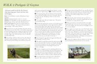
North Wirral Coast
North Wirral Coast
North Wirral Coast

You also want an ePaper? Increase the reach of your titles
YUMPU automatically turns print PDFs into web optimized ePapers that Google loves.
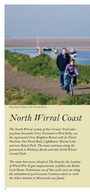
Near Dove Point on the <strong>North</strong> Shore.<br />
<strong>North</strong> <strong>Wirral</strong> <strong>Coast</strong><br />
The <strong>North</strong> <strong>Wirral</strong> section of the Circular Trail takes<br />
you from Seacombe Ferry Terminal to West Kirby, via<br />
the rejuvenated New Brighton Resort with its Floral<br />
Pavilion, Fort Perch Rock, Lighthouse, Marine Lake<br />
and new Retail Park. The route continues along the<br />
promenade to Wallasey Beach and into <strong>North</strong> <strong>Wirral</strong><br />
<strong>Coast</strong>al Park.<br />
The route then turns inland at The Gunsite, the location<br />
of World War II gun emplacements, to follow the Birket<br />
Cycle Route. Pedestrians can if they wish carry on along<br />
the embankment past Leasowe Common where in 1864<br />
the oldest skeleton in Merseyside was found.<br />
2
Moreton Beach is where the world’s first passenger<br />
hovercraft service operated to Rhyl in <strong>North</strong> Wales.<br />
The route joins <strong>North</strong> Shore near Leasowe Lighthouse,<br />
which is the oldest brick built lighthouse in the country.<br />
Together horse riders, walkers and cyclists can continue<br />
past the prehistoric sunken forest and onto Meols,<br />
famous for the number of archaeological metal finds<br />
that have been made there totalling over 5,000<br />
and most of which date from 500BC to 1500AD.<br />
At King’s Gap, cyclists head inland, whilst pedestrians<br />
can continue along the foreshore or via Stanley Road to<br />
Red Rocks and onto West Kirby.<br />
3
<strong>North</strong> <strong>Wirral</strong> <strong>Coast</strong><br />
Seacombe - Tower Grounds<br />
1 Seacombe Ferry Terminal<br />
and Spaceport<br />
This is one of two sites in<br />
<strong>Wirral</strong> from which you can take<br />
a trip on the Mersey Ferry to<br />
Liverpool. Also based here is the<br />
£10 million, space-themed<br />
attraction, Spaceport which<br />
takes you on an inspirational journey through space<br />
through the several themed galleries, all of which feature<br />
a large variety of interactive hands-on exhibits and audio<br />
visual experiences.<br />
3<br />
Wallasey Town Hall<br />
Wallasey Town Hall was built<br />
to replace the old Town Hall and<br />
its foundation stone was laid into<br />
position by means of electricity,<br />
by King George V in 1914, while<br />
9,000 school children sang in the<br />
choir. Its nickname 'back-tofront'<br />
town hall arose as it was built to face the river and<br />
has a fine flight of steps leading up from the promenade.<br />
4<br />
Magazines Promenade looking towards Liverpool.
2<br />
Guinea Gap Baths<br />
Guinea Gap Baths in Seacombe<br />
is the oldest pool in <strong>Wirral</strong>.<br />
Between 1908 and 1957 no fewer<br />
than 205 world and national<br />
swimming records were achieved<br />
here. Its name is derived from<br />
the days before the promenade<br />
was built where there was a break in the riverbank known<br />
to locals as Guinea Gap. This was a popular place for<br />
anyone wishing to go for a swim as it was free from<br />
dangerous currents that lurk in the river itself.<br />
4 The Magazines area<br />
and Vale Park<br />
The area was established in the<br />
1750s when the Port of Liverpool<br />
set up the major gunpowder and<br />
weaponry storage magazines in<br />
the local sand dunes. Opened in<br />
1889, Vale Park became a public<br />
park in 1899 and was one of the best small parks in the north.<br />
With its excellent acoustics and striking appearance the<br />
bandstand is the main feature of the park.<br />
5
<strong>North</strong> <strong>Wirral</strong> <strong>Coast</strong><br />
Seacombe - Tower Grounds<br />
New Brighton<br />
Station<br />
Clockwise<br />
Anti-clockwise<br />
rake lane<br />
rowson st<br />
seabank<br />
road<br />
New<br />
Brighton<br />
Tower<br />
Grounds<br />
Tower<br />
Grounds<br />
Vale<br />
Park<br />
NCN<br />
Route 56<br />
magazine prom.<br />
4<br />
tow<br />
er<br />
prom.<br />
3<br />
war<br />
memorial<br />
NCN Route 56<br />
EGREMONT<br />
Egremont<br />
king street brighton st<br />
PROM.<br />
slipway<br />
River Mersey<br />
3<br />
2<br />
Wallasey<br />
Town Hall<br />
2<br />
borough<br />
road<br />
Seacombe<br />
NCN Route 56<br />
dock<br />
road<br />
East Float<br />
Spaceport<br />
churc h<br />
rd<br />
birkenhead road<br />
1<br />
Tunnel vent<br />
1<br />
KINGSWAY<br />
Seacombe<br />
Ferry Terminal<br />
© Crown copyright and database rights 2011. Ordnance Survey 100019803.<br />
6
Anti-clockwise:<br />
Seacombe - Tower Grounds<br />
1 - 2 From Seacombe Ferry Terminal follow the signs<br />
for New Brighton keeping the river on the right. Passing<br />
the Wallasey-Liverpool Tunnel ventilation shaft on your<br />
left and marker post for New Brighton.<br />
2 - 3 Pass Guinea Gap. Wallasey beach is on the right<br />
and Wallasey Town Hall is on the left. Continue to<br />
Egremont Ferry slipway towards New Brighton past the<br />
War memorial and then Vale Park is on your left and the<br />
Magazine Promenade is ahead. Continue onto Tower<br />
Promenade with the Tower Grounds on the left.<br />
Clockwise:<br />
Tower Grounds - Seacombe<br />
3 - 2 Having past Tower Grounds on your right, continue<br />
along the promenade passing Vale Park on the right and<br />
onto Egremont Ferry slipway and public house.<br />
2 - 1 Continue along past Wallasey Town Hall and<br />
Guinea Gap to the Seacombe Ferry Terminal.<br />
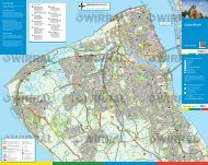
Key for map pages<br />
1<br />
1<br />
<strong>Wirral</strong> Circular Trail<br />
Walking route only<br />
Cycling route<br />
Route Numbers<br />
Places of interest<br />
National Cycle<br />
Network Route 56<br />
Motorway<br />
Roads<br />
Rail route<br />
Train Station<br />
Mersey Tunnel<br />
Ferry Service<br />
Public Footpaths<br />
Public Bridleways<br />
Visitor Centre<br />
Refreshments<br />
Pubic House<br />
Toilets<br />
Parking<br />
0 0.5<br />
1Km<br />
0 Approx. 10-15 minutes walk ½ mile<br />
7
<strong>North</strong> <strong>Wirral</strong> <strong>Coast</strong><br />
New Brighton Seafront<br />
1 New Brighton<br />
past and present<br />
New Brighton has been a seaside<br />
resort for nearly 200 years. It was<br />
created and named by Liverpool<br />
merchant, James Atherton in<br />
1830 as a seaside retreat for the<br />
gentry. In the latter half of the<br />
19th century it developed into a popular seaside resort for<br />
the surrounding industrial towns. It suffered a decline in the<br />
latter part of the last century but has been the recipient of<br />
huge investment through ‘Brand New Brighton’.<br />
3<br />
Fort Perch Rock<br />
Fort Perch Rock was completed<br />
in 1829 as a permanent<br />
fortification to protect the Port<br />
of Liverpool in times of war.<br />
Inside today lies a cornucopia of<br />
exhibits ranging from World<br />
War II aviation to naval history<br />
displays of the doomed submarine HMS Thetis, the<br />
Lusitania and the Titanic. Even Beatles and Elvis Presley<br />
memorabilia is on show inside this unusual fortress at the<br />
mouth of the Mersey Estuary.<br />
8<br />
Fort Perch Rock with Rock Lighthouse that was decommissioned in 1973.
2<br />
The Floral Pavilion<br />
In its hey-day New Brighton<br />
was the accepted rendezvous<br />
for theatre goers and with<br />
seven theatres, was rich in live<br />
entertainment. With the decline<br />
of the resort, the Floral Pavilion<br />
was the last to survive. ‘Brand<br />
New Brighton’ partly funded by The European Regional<br />
Development Fund was used to create the award-winning<br />
new Floral Pavilion that exists today.<br />
4 Tower Grounds<br />
This is where the Tower Ballroom<br />
and New Brighton Tower itself<br />
used to be. The tower was<br />
completed in 1900, 10 years after<br />
Blackpool Tower and, at 567ft<br />
(173m), was 49ft (15m) taller. It<br />
was modelled on the Eiffel Tower,<br />
attracted over 500,000 visitors a<br />
year in it's hey-day and featured<br />
one of the largest ballrooms in the world. Sadly, due to the<br />
war, the Tower became neglected and was finally dismantled<br />
in 1921.<br />
9
<strong>North</strong> <strong>Wirral</strong> <strong>Coast</strong><br />
New Brighton Seafront<br />
6<br />
Clockwise<br />
Anti-clockwise<br />
north wirral coastal park<br />
7<br />
National Cycle Network<br />
Route 56<br />
Wallasey<br />
Golf Course<br />
Liverpool Bay<br />
Wallasey Grove<br />
Road Station<br />
5<br />
Lifeguard<br />
Station<br />
harrison drive<br />
king’s par<br />
telegraph<br />
lane<br />
green lane<br />
8<br />
green lane<br />
Wallasey Village<br />
Station<br />
© Crown copyright and database rights 2011. Ordnance Survey 100019803.<br />
Anti-clockwise:<br />
Tower Grounds - <strong>North</strong> <strong>Wirral</strong> <strong>Coast</strong>al Park<br />
3 - 4 Arrive at New Brighton with the mouth of the River<br />
Mersey on your right and the Floral Pavilion on your left.<br />
Fort Perch Rock is ahead on the right.<br />
4 - 5 Follow the coastal promenade past the shops and other<br />
attractions of New Brighton and eventually past the new<br />
Neptune Development to the Pierrot roundabout and the<br />
new Swan Lake. From the roundabout, continue along the<br />
promenade keeping the King’s Parade on your left and the<br />
sea on your right to the Lifeguard Station where the cycle<br />
track becomes the coastal path.<br />
10
oad<br />
ade<br />
A554<br />
coastal drive<br />
Pierrot<br />
king’s<br />
parade<br />
New Brighton<br />
Station<br />
king’s<br />
parade<br />
marine<br />
prom.<br />
rowson st<br />
seabank<br />
Fort<br />
Perch Rock<br />
Marine Lake<br />
Tower<br />
Grounds<br />
Rock<br />
Lighthouse<br />
1<br />
New 2<br />
Brighton<br />
Tower<br />
Grounds<br />
Vale<br />
Park<br />
3<br />
4<br />
NCN<br />
Route 56<br />
tow<br />
er<br />
magazine pro<br />
4<br />
prom.<br />
3<br />
Clockwise:<br />
<strong>North</strong> <strong>Wirral</strong> <strong>Coast</strong>al Park - Tower Grounds<br />
5 - 4 From the Lifeguard Station where the coastal<br />
path becomes the cycle track, continue along the seafront<br />
promenade keeping King’s Parade on your right and the<br />
sea on your left all the way to New Brighton.<br />
4 - 3 Arrive in New Brighton, passing the new Neptune<br />
Development, with the mouth of the River Mersey and<br />
Fort Perch Rock ahead on the left. Follow the coastal<br />
promenade, past the shops and other attractions of New<br />
Brighton on your right. Eventually the promenade turns<br />
right from the seafront to the Mersey Estuary promenade<br />
and past the Floral Pavilion.<br />
The Tower Grounds will now appear on your right.<br />
11
<strong>North</strong> <strong>Wirral</strong> <strong>Coast</strong><br />
The <strong>North</strong> Shore -<br />
River Birket<br />
1<br />
<strong>North</strong> <strong>Wirral</strong> <strong>Coast</strong>al Park<br />
The <strong>North</strong> <strong>Wirral</strong> <strong>Coast</strong>al Park<br />
was established in 1986 and<br />
stretches from Derby Pool at the<br />
Wallasey end to Dove Point at<br />
Meols, a distance of about 3.5<br />
miles. The entire length of the<br />
park is bordered on its seaward<br />
side by a manmade embankment. An embankment of some<br />
description has been present on the <strong>North</strong> <strong>Wirral</strong> foreshore<br />
for 250 years.<br />
The <strong>Coast</strong>al Rangers undertake regular projects<br />
within the dunes to encourage stabilisation through<br />
vegetation management. Sand is imported into the dunes<br />
as they are cut off from their natural supply by the sea<br />
defence embankment. They once formed a natural defence<br />
against the sea and gave shelter from strong sea winds.<br />
The Park is a collection of open spaces behind the sea<br />
embankment that include the Gunsite picnic area and<br />
Leasowe Common, with numerous open grassed areas in<br />
between Leasowe Lighthouse can been seen from points<br />
within the park. The lighthouse is at the western end of<br />
Leasowe Common near to the hay meadow and the start<br />
of the River Birket cycle track.<br />
12<br />
Derby Pool cyclepath with the mouth of the River Mersey in the distance.
2<br />
The Gunsite and<br />
Leasowe Dunes<br />
The Gunsite was formerly an<br />
anti-aircraft station during the<br />
Second World War, established<br />
to protect the docks and<br />
surrounding areas from air raid.<br />
It is now a picnic area and<br />
wildlife haven for numerous butterflies and bees.<br />
The sand dunes are situated between Leasowe Bay and<br />
the Gunsite. They once formed a natural defence against<br />
the sea and gave shelter from strong winds. They are a<br />
unique and threatened habitat nationally, containing a<br />
variety of species including Sand Lizard, Burnet Moth,<br />
Marram and Lyme grasses. Look out for Kestrel and<br />
Skylark flying above your head.<br />
3 Derby Pool<br />
The Derby Pool was formerly<br />
an open air swimming pool.<br />
Some of the structure still<br />
remains as shelters. Here you<br />
can get stunning views over<br />
Liverpool Bay with glorious<br />
sunsets in the evening. There<br />
is now a pub/restaurant on-site with a mini golf course<br />
and clean beaches nearby.<br />
13
<strong>North</strong> <strong>Wirral</strong> <strong>Coast</strong><br />
The <strong>North</strong> Shore -<br />
River Birket<br />
Clockwise<br />
Anti-clockwise<br />
6<br />
The Gunsite<br />
Picnic Area<br />
Optional route for experienced road cyclists<br />
2<br />
leasowe road<br />
Liverpool Bay<br />
north wirral coastal park<br />
7<br />
telegraph<br />
lane<br />
1<br />
National Cycle Network<br />
Route 56<br />
Wallasey<br />
Golf Course<br />
green lane<br />
8<br />
A551<br />
9<br />
3<br />
5<br />
harrison drive<br />
green lane<br />
leasowe roa<br />
NCN Route 56<br />
Lifeguard<br />
Station<br />
Wallasey Grove<br />
Road Station<br />
Wallasey Village<br />
Station<br />
Leasowe<br />
River Birket<br />
10<br />
davis<br />
rd<br />
Metal bridge<br />
River Birket<br />
Bidston<br />
Golf Course<br />
M53<br />
Bidston Moss<br />
Nature Reserve<br />
© Crown copyright and database rights 2011. Ordnance Survey 100019803.<br />
Anti-clockwise:<br />
<strong>North</strong> <strong>Wirral</strong> <strong>Coast</strong>al Park - River Birket<br />
5 - 6 From the Lifeguard Station the cycle track becomes<br />
the coastal path. Continue along to the Derby Pool car park.<br />
Follow the trail along the north shore, cyclists on cyclepath<br />
and walkers alongside.<br />
6 At this point the route turns inland. (Walkers have an<br />
option to walk along the concrete track of the sea defence<br />
wall because of the current by-law prohibiting cycling.)<br />
Leasowe Lighthouse can be seen in the distance ahead.<br />
J1<br />
14
7 - 8 From the north shore, continue along the track. Care<br />
needs to be taken because this is a shared use bridleway with<br />
motor vehicles accessing the car parks. Follow the track left<br />
into Green Lane and after 200yds turn right into Telegraph<br />
Lane. National Cycle Network Route 56 continues straight on<br />
into central <strong>Wirral</strong>.<br />
8 - 9 At the main Leasowe Rd, the route continues across<br />
the road to the right of the garage. Take care crossing this<br />
busy dual carriageway. You may wish to cross this road at the<br />
pelican crossing about 200yds left or at the roundabout 100yds<br />
to the right. Enter the playing fields area leaving the garage<br />
and houses on your left, continue across the playing fields.<br />
Before the houses, turn left across the field with the houses<br />
on the right until you get to the raised embankment.<br />
9 - 10 Turn right onto the raised embankment with the<br />
river on the left and the houses on your right. Follow this<br />
grass path past the access path to the Golf Club on the left.<br />
The path turns right to run alongside the main River Birket<br />
on your left. Continue to the metal bridge where you turn left<br />
and then immediately right.<br />
Clockwise:<br />
River Birket - <strong>North</strong> <strong>Wirral</strong> <strong>Coast</strong>al Park<br />
10 - 9 From the metal bridge, follow the grass path around<br />
to the left, keeping the river on your right. Past the path to<br />
the Golf Club on your right, and continue along until the<br />
embankment reaches the end of the line of houses.<br />
9 - 8 Turn left to go across the playing field to the surfaced<br />
path. Turn right onto this path which leads out to Leasowe Rd.<br />
8 - 7 The route now follows Telegraph Lane that is<br />
diagonally right across the road. Take care crossing the busy<br />
dual carriageway. Consider using the pelican crossing or<br />
roundabout nearby. Follow this bridleway to the end, where<br />
you turn left, the NCN Route 56 joins the trail from central<br />
<strong>Wirral</strong> from your right. After 200yds turn right with the<br />
Gunsite car park now on your left.<br />
7 - 6 Take care along this track because it is a shared use<br />
route with motor vehicles accessing the <strong>North</strong> <strong>Wirral</strong> <strong>Coast</strong>al<br />
Park car parks. Continue along the track until you reach the<br />
sea defence wall.<br />
6 - 5 Turn right and follow the trail along the north shore,<br />
cyclists on cyclepath and walkers alongside. When you get to<br />
the Derby Pool car park, continue along in front of the car<br />
park on the coastal path past the Lifeguard Station and along<br />
the seafront promenade to New Brighton.<br />
15
<strong>North</strong> <strong>Wirral</strong> <strong>Coast</strong><br />
Leasowe Lighthouse -<br />
River Birket<br />
1 Leasowe Lighthouse<br />
Built in 1763 by the Mersey<br />
Docks and Harbour Board,<br />
Leasowe Lighthouse is the oldest<br />
brick built lighthouse in Britain<br />
and possibly the first building of<br />
its kind in the world to use cavity<br />
walls for insulation. It stands<br />
101ft (27m) tall on Leasowe Common. It was one of four<br />
lights on the <strong>North</strong> <strong>Wirral</strong> Foreshore used to guide ships into<br />
the entrance to the Rock Channel and the Port of Liverpool.<br />
Now a site of public interest, and a Grade II Listed<br />
monument, the Lighthouse features guided tours and special<br />
events with displays about Leasowe Lighthouse, the <strong>North</strong><br />
<strong>Wirral</strong> <strong>Coast</strong>al Park and the <strong>Wirral</strong> <strong>Coast</strong>line.<br />
3<br />
River Birket<br />
Most small rivers on <strong>North</strong><br />
<strong>Wirral</strong> flow into The Birket,<br />
the river from which Birkenhead<br />
takes its name. The Birket<br />
flows from near West Kirby to<br />
Birkenhead docks, much of the<br />
surrounding is reclaimed marsh.<br />
This area provides a rich habitat corridor for animals and<br />
birds. Look out for herons and ducks along the trail.<br />
16<br />
The bridleway track from the north shore to Leasowe Lighthouse.
2 Leasowe Castle<br />
Leasowe Castle was built by<br />
Ferdinando Stanley, 5th Earl<br />
of Derby around 1593, possibly<br />
as an observation platform for<br />
the Wallasey Races which took<br />
place on the sands opposite at<br />
Leasowe in the 16th and 17th<br />
centuries and which are regarded as a forerunner of the<br />
Derby races. At first the Castle consisted only of an<br />
octagonal tower. This had become disused by 1700, and<br />
it became known as ‘Mockbeggar Hall’. The term<br />
‘Mockbeggar Wharf ’ is still used for the adjoining<br />
foreshore. Leasowe Castle is now a hotel.<br />
4<br />
Leasowe Bay<br />
Leasowe Bay is a secluded area<br />
which is becoming popular<br />
with surfers and windsurfers.<br />
A boardwalk path through the<br />
dunes gives access to a hay<br />
meadow and the Gunsite picnic<br />
area, a former anti-aircraft base.<br />
17
<strong>North</strong> <strong>Wirral</strong> <strong>Coast</strong><br />
Leasowe Lighthouse -<br />
River Birket<br />
12<br />
park lane<br />
3<br />
River Birket<br />
1<br />
Leasowe<br />
Lighthouse<br />
north wirral coastal pa<br />
11<br />
leasow<br />
Clockwise<br />
Anti-clockwise<br />
pasture lane<br />
Moreton<br />
Station<br />
3<br />
© Crown copyright and database rights 2011. Ordnance Survey 100019803.<br />
Anti-clockwise:<br />
River Birket - Leasowe Lighthouse<br />
10 - 11 At the metal bridge near to Davis Rd, turn left<br />
over the bridge and then immediate right. Follow the path<br />
along until you come to Reeds Lane, where you turn right<br />
and then immediate left onto the riverside path keeping<br />
the River Birket now on your left. Continue along this<br />
path until you come to Pasture Rd, where you turn left,<br />
and then right.<br />
11 - 12 Having crossed the road and onto the track again,<br />
with the river on your left, continue across the fields and<br />
turn left to go past the lighthouse which is on your left.<br />
After the lighthouse car parks on your right, the route<br />
then turns right onto the public bridleway as the road<br />
goes left. Follow this bridleway along until it rejoins the<br />
sea defence wall.<br />
18
k<br />
e road<br />
River Birket<br />
Walkers only<br />
2<br />
reeds lane<br />
4<br />
Optional route for experienced road cyclists<br />
leasowe road<br />
The Gunsite<br />
Picnic Area<br />
Leasowe<br />
6<br />
7<br />
telegraph<br />
lane<br />
NCN Route 5<br />
A551<br />
G<br />
green<br />
8<br />
9<br />
Leasowe<br />
Station<br />
10<br />
Metal<br />
bridge<br />
davis<br />
rd<br />
River Birket<br />
Bidston<br />
Golf Course<br />
Clockwise:<br />
Leasowe Lighthouse - River Birket<br />
12 - 11 From the sea defence wall the route veers right<br />
towards the lighthouse. Eventually, you come to another<br />
track where you turn left, then go past the car parks on<br />
the left and Leasowe Lighthouse is on your right. About<br />
200yds after the lighthouse turn right onto the track that<br />
goes across the field to run alongside the River Birket.<br />
11 - 10 At the junction with Pasture Rd, cross over the<br />
road, turn left and then immediately right onto the<br />
continuation of the River Birket cycle track keeping the<br />
river on your right. Go as far as Reeds Lane, where you<br />
turn right and then immediately, left onto the River Birket<br />
cycle track, keeping the river this time on your left. Keep<br />
going until you get to the metal bridge where you turn left<br />
and then immediately right passing Davis Rd on the left.<br />
Follow this grassed track keeping the river on your right<br />
and the houses on your left.<br />
19
<strong>North</strong> <strong>Wirral</strong> <strong>Coast</strong><br />
Meols Promenade<br />
1 Meols Promenade<br />
Meols has a promenade and<br />
beach which stretches on to<br />
Hoylake and Moreton. Meols is<br />
steeped in Viking history and<br />
there is said to be a Viking Ship<br />
buried under the Railway Inn<br />
car park. It is an excellent spot<br />
to observe waders at low tide. A channel runs close to the<br />
shore here and this attracts the usual Oystercatchers and<br />
Redshank along with a good variety of other species,<br />
including Bar-tailed Godwit and Grey Plover.<br />
3<br />
Hoyle Lake<br />
Pictured here is the new model<br />
boating lake next to the New<br />
Lifeboat Station. For thousands<br />
of years, people had made use of<br />
a natural harbour called the<br />
Hoyle Lake. This gave its name<br />
in modern times to Hoylake.<br />
In the 17th century Hoyle Lake was a deep-water anchorage<br />
for vessels on passage to Chester and the River Dee ports.<br />
By the 1830s, with the silting of the Lake and the River Dee,<br />
the ships docked at Liverpool. By the end of the 19th century,<br />
the Lake had disappeared altogether to form the East Hoyle<br />
sandbank that can be seen in the distance today.<br />
20<br />
<strong>North</strong> Parade, Hoylake with Wales in the distance.
2<br />
The new Hoylake<br />
Lifeboat Station<br />
The Royal National Lifeboat<br />
Institution is the charity that<br />
saves lives at sea. Its volunteers<br />
provide a 24-hour search and<br />
rescue service around the UK<br />
and Ireland coasts. The RNLI<br />
operates over 230 lifeboat stations in the UK and Ireland.<br />
Three lifeboat stations are on or near the <strong>Wirral</strong> Circular<br />
Trail. Today the Mersey class lifeboat ‘Lady of Hilbre’ and<br />
carriage are towed by a caterpillar tracked Talus tractor which<br />
has been specifically designed to launch carriage lifeboats.<br />
4 The old Hoylake<br />
Lifeboat Station<br />
Hoylake Lifeboat station is one<br />
of the oldest on the coasts of<br />
Great Britain and Ireland. It<br />
was founded by the Mersey<br />
Docks & Harbour Board in<br />
1803 and taken over by the<br />
RNLI in 1894. For a time there was also a Lifeboat Station<br />
on Hilbre Island. This Station was closed in the 1930s.<br />
Hoylake has always had a ‘carriage launched’ lifeboat.<br />
In earlier times, the boat was pulled to the water by a team<br />
of horses. Frames for storing the harnesses can still be seen<br />
on the wall of the old boathouse which was built in1899.<br />
21
<strong>North</strong> <strong>Wirral</strong> <strong>Coast</strong><br />
Meols Promenade<br />
Liverpool Bay<br />
3<br />
Old<br />
Lifeboat<br />
Station<br />
New<br />
Lifeboat<br />
Station<br />
4<br />
north parade<br />
14<br />
2<br />
Boating<br />
Lake<br />
hoyle rd<br />
Queen’s<br />
Park<br />
Meols<br />
1<br />
scho<br />
forest<br />
15<br />
KING’S<br />
alderley rd<br />
valentia rd<br />
Hoylake<br />
Station<br />
trinity rd<br />
Hoylake<br />
manor<br />
rd<br />
Manor Road<br />
Station<br />
© Crown copyright and database rights 2011. Ordnance Survey 100019803.<br />
Anti-clockwise:<br />
<strong>North</strong> <strong>Wirral</strong> <strong>Coast</strong>al Park - King’s Gap Hoylake<br />
12 - 13 From point 12 the route returns to the north<br />
shore along to the <strong>Coast</strong>guard Station at Dove Point.<br />
13 - 14 From Dove Point the route then goes around the<br />
end of the sea defence wall and joins Meols Promenade.<br />
Follow this all the way along, keeping the sea on the right,<br />
to the new Lifeboat Station and model boating lake.<br />
14 - 15 Continue along the promenade to King’s Gap.<br />
Please note that from this point the road is one-way in the<br />
opposite direction and according to the by-law, cyclists must not<br />
exceed 10mph! (On the promenade, not the road)<br />
22
oad<br />
13<br />
HM <strong>Coast</strong>guard<br />
Station<br />
north wirral<br />
12<br />
coastal park<br />
park lane<br />
ol<br />
dovepoint<br />
laneroad<br />
Meols<br />
Station<br />
bennet’s lane<br />
park<br />
road<br />
River Birket<br />
River Birket<br />
Clockwise<br />
Anti-clockwise<br />
Clockwise:<br />
King’s Gap Hoylake - <strong>North</strong> <strong>Wirral</strong> <strong>Coast</strong>al Park<br />
15 - 14 From King’s Gap continue along the promenade<br />
to the new Lifeboat Station on the left.<br />
14 - 13 Continue on the route along the promenade<br />
which becomes Meols Parade and follow that until you get<br />
to the slipway at Bennet’s Lane and Dove Point. At this<br />
location the route turns right and then immediate left<br />
behind the sea wall. Walkers have the alternative option of<br />
remaining on the concrete track on the sea defence wall<br />
because of the current by-law prohibiting cycling.<br />
13 - 12 From Dove Point <strong>Coast</strong>guard Station continue<br />
onto the new path on the sea defence embankment. The<br />
route veers to the right away from the sea defence wall<br />
towards Leasowe Lighthouse.<br />
23
<strong>North</strong> <strong>Wirral</strong> <strong>Coast</strong><br />
Hoylake - West Kirby<br />
(Cubbins Green)<br />
1 Hilbre Islands/Red Rocks<br />
The three islands, isolated from<br />
the mainland by the tides, bring a<br />
sense of isolation and castaway feel,<br />
until the ebb tide exposes the beach<br />
again for the walk back to West<br />
Kirby and the everyday world.<br />
Red Rocks, designated as a Site of<br />
Special Scientific Interest, is an area of sand dunes and reedbeds<br />
and home to a variety plants the rarest of which is Mackay's<br />
Horsetail, which is not found in any other location in England.<br />
The area is important for recording migrant birds, and is a<br />
breeding site for Natterjack Toads, a breed common in<br />
mainland Europe, but rare in the UK.<br />
3<br />
King’s Gap<br />
The King’s Gap was so called<br />
because in 1690, Prince William<br />
of Orange joined his ships at the<br />
Hoyle Lake and set sail for<br />
Ireland with his fleet from these<br />
shores for his meeting with King<br />
James. His 10,000 strong army<br />
was victorious in the Battle of the Boyne.<br />
24<br />
Walking out to Hilbre Island at low tide.
2<br />
The Marine Lake<br />
One of the largest man-made<br />
lakes in the UK, it is 52 acres<br />
in size, 5ft deep and totally<br />
enclosed.<br />
The Lake is home to the<br />
<strong>Wirral</strong> Sailing School, which<br />
offers courses in sailing,<br />
windsurfing and canoeing, making it the ideal place to<br />
indulge your adventurous side. The less energetic can also<br />
enjoy the Marine Lake by taking a leisurely stroll around<br />
the lake edge path. At low tide there is a large stretch of<br />
beach from West Kirby to Red Rocks.<br />
4 The Royal Liverpool<br />
Golf Club<br />
Founded in 1869, Hoylake, as it<br />
is called by those in the know,<br />
has a long and illustrious history<br />
of playing host to the British<br />
Open and has now hosted eleven,<br />
its first in 1897. The Open is set<br />
to return to The Royal Liverpool Golf Club in 2014.<br />
25
<strong>North</strong> <strong>Wirral</strong> <strong>Coast</strong><br />
Hoylake - West Kirby<br />
(Cubbins Green)<br />
M<br />
Irish Sea/<br />
Liverpool Bay<br />
Walkers only<br />
stanley rd<br />
4<br />
15<br />
KING’S<br />
3<br />
valentia rd<br />
ey rd<br />
Hoylake<br />
Hoylake<br />
Station<br />
1<br />
Hilbre<br />
Island<br />
Royal Liverpool<br />
Golf Course<br />
Hoylake<br />
Municipal<br />
Golf Course<br />
Walkers only<br />
River Dee<br />
Sailing<br />
Club<br />
16<br />
West Kirb y Station<br />
orrysdale<br />
rd<br />
Morrisons<br />
greenbank rd<br />
jubilee<br />
dr.<br />
brighton<br />
ave.<br />
West<br />
Kirby<br />
Concourse<br />
Ashton<br />
Park<br />
17<br />
Grange<br />
Hill<br />
grange rd<br />
bridge<br />
war<br />
memorial<br />
2<br />
Marine<br />
Lake<br />
church rd<br />
Walkers only<br />
Clockwise<br />
Anti-clockwise<br />
m acdona<br />
dr.<br />
Cubbins<br />
Green<br />
18<br />
melloncroft<br />
drive<br />
Caldy<br />
Hill<br />
© Crown copyright and database rights 2011. Ordnance Survey 100019803.<br />
26
Anti-clockwise:<br />
Hoylake - West Kirby (Cubbins Green)<br />
15 From the promenade at King’s Gap turn left. There is<br />
the alternative option for walkers to remain on the beach<br />
and follow the coastline around to West Kirby. This should<br />
be possible at anytime other than at very high tides.<br />
Unless you take the beach route, continue into King’s Gap<br />
and go along to the junction of Stanley Rd. At this point,<br />
walkers and cyclists have separate routes.<br />
15 - 18<br />
Walkers: Having turned right into Stanley Rd from King’s<br />
Gap continue along to the end keeping the Royal Liverpool<br />
Golf Club on the left. At the end of Stanley Rd turn left<br />
onto the beach and follow the beach path. Keep the sand<br />
dunes on your left all the way to West Kirby promenade.<br />
At the end of Dee Lane, in front of Morrisons car park, the<br />
information board at this location gives details of suitable<br />
times to walk to Hilbre Island. There is the Sailing Club<br />
and Marine Lake to the right, and at this location walkers<br />
have 3 options.<br />
Option 1: Turn left into Dee Lane passing Morrisons on<br />
the right. At the end of Dee Lane turn right into Grange<br />
Rd, keeping West Kirby railway station and the Concourse<br />
on the left. The start of the <strong>Wirral</strong> Way is on the right.<br />
Option 2: Continue along the promenade with the Marine<br />
Lake on the right all the way to the end. When you get to<br />
the West Kirby Sailing Club turn left then right, into<br />
Macdona Drive. Follow this along to Cubbins Green.<br />
The route continues across the grassed area and you are<br />
able to join the <strong>Wirral</strong> Way at two locations on your left.<br />
Option 3: Turn right at the end of Dee Lane and walk<br />
around the Marine Lake path where it joins the West<br />
Kirby Sailing Club, the instructions are as Option 2.<br />
Opposite the Cubbins Green access to the <strong>Wirral</strong> Way is<br />
Melloncroft Drive that leads straight up to the public<br />
footpaths of Caldy Hill.<br />
27
<strong>North</strong> <strong>Wirral</strong> <strong>Coast</strong><br />
Hoylake - West Kirby<br />
(Cubbins Green)<br />
15 - 18<br />
Cyclists: Continue straight on from King’s Gap over the<br />
roundabout and straight over the level crossing next to<br />
Hoylake station. Take the turn immediately right onto the<br />
cycle track that runs adjacent to the railway. At the end of this<br />
cycle track turn left into Greenbank Rd, then immediately<br />
right into Jubilee Drive and then fork right into Brighton<br />
Avenue. Follow the paths between the houses until they exit<br />
onto the open grassed area and then turn right and left into<br />
Orrysdale Rd. Follow this road past the petrol station on the<br />
left and West Kirby Concourse on the right. The start of the<br />
<strong>Wirral</strong> Way is opposite the end of Orrysdale Rd. Continue<br />
along the <strong>Wirral</strong> Way to Cubbins Green.<br />
Clockwise:<br />
West Kirby (Cubbins Green) - Hoylake<br />
18 - 15<br />
As walkers and cyclists approach West Kirby from<br />
Thurstaston, walkers are presented with 2 options.<br />
Option 1: When on the <strong>Wirral</strong> Way, you can turn left<br />
onto Cubbins Green at two locations. Follow this grassed<br />
area along the cliff top to the road. This is Macdona Drive,<br />
which you should follow to the end, and turn left up to the<br />
start of the West Kirby promenade with the Sailing Club<br />
on the left.<br />
From this point you can choose whether to walk around<br />
the Marine Lake, or turn right and follow the promenade<br />
along, keeping the Marine Lake on your left.<br />
The Marine Lake path and the promenade meet up at the<br />
junction with Dee Lane in front of Morrisons car park.<br />
Option 2: Walkers can remain on the <strong>Wirral</strong> Way to its<br />
end where you will need to turn left into Grange Rd<br />
leaving West Kirby Concourse and the railway station on<br />
your right. Pass both these locations and turn left into<br />
Dee Lane. Follow this road keeping Morrisons to your<br />
left until you get to the seafront.<br />
28
With Morrisons behind you, turn right onto the beach,<br />
leaving the Marine Lake behind you. The information<br />
board at this location gives suitable times to walk out<br />
to Hilbre Island.<br />
Follow the beach path, passing the sand dunes on your<br />
right, until you get to the rocky area locally known as Red<br />
Rocks. At the end of Stanley Rd where you can turn right,<br />
follow Stanley Rd to the end keeping the Royal Liverpool<br />
Golf Club on your right. At the end of Stanley Rd turn left<br />
into King’s Gap to the seafront promenade.<br />
It is possible to remain on the beach and go around from<br />
Red Rocks to Hoylake Promenade at times other than<br />
when there is a very high tide.<br />
18 - 15<br />
Cyclists: From Cubbins Green, continue to the end of<br />
the <strong>Wirral</strong> Way and go straight over into Orrysdale Rd<br />
keeping West Kirby Concourse on your left and the<br />
petrol station on your right. At the end of Orrysdale Rd,<br />
turn right and immediate left onto the track behind the<br />
houses and follow this through to Jubilee Drive, and then<br />
left into Greenbank Rd. Turn immediately right on the<br />
bend onto the cycle track which takes you all the way to<br />
Hoylake railway station, where you turn left over the level<br />
crossing. Continue over the roundabout into King’s Gap<br />
and straight down to the seafront promenade.<br />
Hoylake to West Kirby cycle track.<br />
29