Final Plat - New Albany, Ohio
Final Plat - New Albany, Ohio
Final Plat - New Albany, Ohio

You also want an ePaper? Increase the reach of your titles
YUMPU automatically turns print PDFs into web optimized ePapers that Google loves.
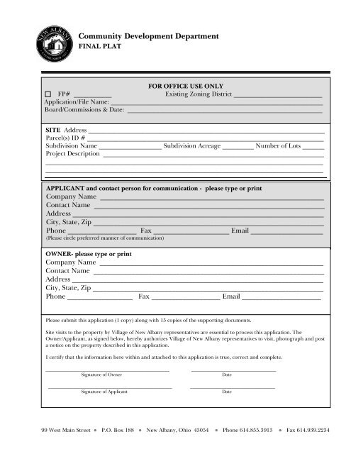
Community Development Department<br />
FINAL PLAT<br />
FOR OFFICE USE ONLY<br />
FP# ____________<br />
Existing Zoning District ____________________________<br />
Application/File Name: __________________________________________________________________________<br />
Board/Commissions & Date: ____________________________________________________________________<br />
SITE Address ___________________________________________________________________________<br />
Parcel(s) ID # ___________________________________________________________________________<br />
Subdivision Name ____________________ Subdivision Acreage __________ Number of Lots _______<br />
Project Description ______________________________________________________________________<br />
________________________________________________________________________________________<br />
________________________________________________________________________________________<br />
____________________________________________________<br />
APPLICANT and contact person for communication - please type or print<br />
Company Name _________________________________________________________________<br />
Contact Name ___________________________________________________________________<br />
Address _________________________________________________________________________<br />
City, State, Zip ___________________________________________________________________<br />
Phone ____________________ Fax ______________________ Email _____________________<br />
(Please circle preferred manner of communication)<br />
OWNER- please type or print<br />
Company Name _________________________________________________________________<br />
Contact Name ___________________________________________________________________<br />
Address _________________________________________________________________________<br />
City, State, Zip ___________________________________________________________________<br />
Phone ___________________ Fax ____________________ Email _______________________<br />
Please submit this application (1 copy) along with 15 copies of the supporting documents.<br />
Site visits to the property by Village of <strong>New</strong> <strong>Albany</strong> representatives are essential to process this application. The<br />
Owner/Applicant, as signed below, hereby authorizes Village of <strong>New</strong> <strong>Albany</strong> representatives to visit, photograph and post<br />
a notice on the property described in this application.<br />
I certify that the information here within and attached to this application is true, correct and complete.<br />
______________________________________________________<br />
Signature of Owner<br />
______________________________________________________<br />
Signature of Applicant<br />
_____________________________________<br />
Date<br />
_____________________________________<br />
Date<br />
99 West Main Street ● P.O. Box 188 ● <strong>New</strong> <strong>Albany</strong>, <strong>Ohio</strong> 43054 ● Phone 614.855.3913 ● Fax 614.939.2234
Fee $___________________________<br />
FOR OFFICE USE ONLY<br />
Approved By ________ Date __________________ Conditions ___________________<br />
(Staff initials)<br />
Denied By _________ Date __________________ Notes _______________________<br />
(Staff initials)<br />
Permit # _________________<br />
99 West Main Street ● P.O. Box 188 ● <strong>New</strong> <strong>Albany</strong>, <strong>Ohio</strong> 43054 ● Phone 614.855.3913 ● Fax 614.939.2234
Community Development Department<br />
FINAL PLAT<br />
SUBMITTAL REQUIREMENTS<br />
____________________________________________________________________________________<br />
Please return page one of this application packet. Retain these additional pages for your records.<br />
NOTE TO APPLICANTS:<br />
• Applications must be submitted 30 days in advance of the hearing date.<br />
• This document is intended to provide minimum requirements for most projects. Some projects<br />
may require additional information not listed here, as determined by Village Staff. Applicants will<br />
be notified if additional information is required prior to the hearing date.<br />
• The applicant is responsible for the accuracy and completeness of all application materials.<br />
Incorrect or incomplete information may result in delay or denial of your application.<br />
• All application materials become the property of the Village of <strong>New</strong> <strong>Albany</strong> and are subject to<br />
public review.<br />
• Submit one (1) copy of the completed application form and fifteen (15) copies of all supporting<br />
documentation. All plans, maps and architectural drawings must be to scale. Please make sure all<br />
materials are stapled and collated. Large plans should also be folded, but not stapled to the other application materials.<br />
________________________________________________________________________________________________________________<br />
Please submit the following information:<br />
1. Completed <strong>Final</strong> <strong>Plat</strong> Application Form<br />
2. Required fee (as determined by the Village of <strong>New</strong> <strong>Albany</strong> Fee Schedule).<br />
3. Copies of any and all proposed deed covenants, deeds of right-of-way and deeds of easement.<br />
4. Evidence that the <strong>Ohio</strong> Environmental Protection Agency has considered the applicant’s<br />
application and granted such permit or determined that such permit is not applicable. If a permit<br />
was granted, four (4) copies shall be supplied by the owner to the Zoning Officer for distribution.<br />
5. Evidence that the U.S. Army Corps of Engineers has considered the applicant’s application and<br />
granted such permit or determined that such permit is not applicable. If a permit was granted,<br />
four (4) copies shall be supplied by the owner to the Zoning Officer for distribution. After the<br />
tracing (final plat drawing) has been revised to reflect the review comments, eight (8) copies<br />
showing all approvals, shall be supplied by the owner to the Finance Director for distribution.<br />
6. <strong>Final</strong> <strong>Plat</strong>, with a minimum scale of one (1) inch equals one hundred (100) feet, containing the<br />
following information:<br />
A. Boundary of plat, based on an accurate distances and bearings.<br />
B. Where the subdivision does not abut to an existing subdivision, the true angle and<br />
distance to the nearest street intersection, accurately described on the plat.<br />
C. Municipal, Township, County or Section lines accurately tied to the lines of the<br />
subdivision by distances and angles. Radii, arcs and chords, points of curvature and<br />
tangency. Central angles for all curvilinear streets and radius for all rounded corners.<br />
D. All lot numbers and lines with accurate dimensions in decimals of a foot and bearings in<br />
degrees, minutes and seconds.<br />
E. One inch iron pins, 30" long, with plastic caps identifying the surveyor shall be placed at<br />
such locations that the subdivisions can be readily resurveyed. As a minimum, all<br />
extreme corners shall be monumented.
F. Accurate location, width of right-of-way and name of all streets or other public ways.<br />
G. All proposed developer easements, such as water, sanitary and storm sewers shall be<br />
shown. All proposed public utility easements shall be shown if they are available.<br />
H. Minimum building setback lines along all streets and other public ways.<br />
I. Accurate outlines and delineation of all drainage easements, 100 year floodway routing,<br />
flood hazard areas and other watercourses contained within or contiguous to the plat<br />
boundaries.<br />
J. Accurate outlines of any areas to be dedicated or reserved for public use, with purposes<br />
indicated thereon, and of any areas to be reserved by deed covenant, for the common<br />
use of all property owners.<br />
K. If more than one sheet is required for the plat, an index map, at a smaller scale, showing<br />
all of the lots on one contiguous drawing shall be shown on the first sheet.<br />
L. A certification by a registered surveyor that the plat represents a survey made by him<br />
and that the monuments shown exist as located, or will be set one foot below proposed<br />
grade prior to beginning of construction, and that all dimensional and geodetic details<br />
are correct. The plat shall be prepared in accordance with the minimum plat<br />
requirements as established by the Franklin County Engineer's Office.<br />
M. A notarized certification by the owner/owners of the adoption of the plat and the<br />
dedication by them to public use of the streets and other public areas shown on the plat.<br />
No property should extend to center of rights-of-way.<br />
N. Proper form for the approval of the Planning Commission, with space for signature of the<br />
Chairperson.<br />
O. Space for approval by signature of the Mayor, Municipal Engineer, Council<br />
representative to Planning Commission and Finance Director. The signature of the<br />
Engineer shall be withheld until all easements are shown.<br />
P. Proper form for approval and acceptance by the Council, showing resolution number.<br />
Q. Space for transfer by the County Auditor and recording by the County Recorder. A<br />
statement as to the expiration date of the municipal approval shall be placed just ahead<br />
of the space provided for the County Auditor's signature.<br />
7. Electronic copy of proposed preliminary plat in CAD format.<br />
8. Electronic copy of proposed final plat in PDF format.