GLUPB Presentation - June 9 2005.pdf - Peel Watershed Planning ...
GLUPB Presentation - June 9 2005.pdf - Peel Watershed Planning ...
GLUPB Presentation - June 9 2005.pdf - Peel Watershed Planning ...

You also want an ePaper? Increase the reach of your titles
YUMPU automatically turns print PDFs into web optimized ePapers that Google loves.
Gwich’in Land Use<br />
<strong>Planning</strong> Board<br />
Work related to Transboundary and<br />
the <strong>Peel</strong> <strong>Watershed</strong> Issues
Mandate<br />
• Provision for the Gwich’in Land Use <strong>Planning</strong><br />
Board was made through the Gwich’in<br />
Comprehensive Land Claim Agreement in 1992.<br />
• the <strong>Planning</strong> Board operated as an interim board<br />
1994 - 1998<br />
• was officially established by the Mackenzie<br />
Valley Resource Management Act in 1998.<br />
• the Board has developed and is implementing a<br />
land use plan for the Gwich’in Settlement Area.<br />
• the Plan was approved in August 2003.
Land Use Plan – Objectives:<br />
• Land use plan provides for the conservation,<br />
development and utilization of land, water and<br />
resources.<br />
• The plan is particularly devoted to the needs of<br />
the Gwich’in, while considering the needs of all<br />
Canadians.<br />
• Those authorities with jurisdiction to grant<br />
licences, permits, leases, or interests relating to<br />
the use of land and water in the settlement area<br />
shall conduct their activities and operations in<br />
accordance with the plan.
Board Members & Staff<br />
The <strong>Planning</strong> Board has four members, the Gwich'in Tribal Council<br />
nominates two members, the GNWT and the Federal Government<br />
nominate one member. Together, the members nominate the<br />
Chair; all of which are appointed by the Minister.<br />
1.Bob Simpson, Chair<br />
2.Charlie Snowshoe Vice Chair<br />
3.Ian McLeod<br />
4.Fanny Greenland<br />
5.Joseph Tetlichi<br />
– Board<br />
– GTC<br />
– GTC<br />
– GNWT<br />
– Federal Government<br />
Current Staff<br />
Planner : Susan McKenzie<br />
<strong>Planning</strong> Assistant: Amy Wright
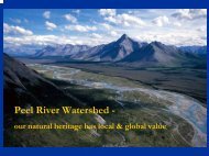
Transboundary – <strong>Peel</strong> River<br />
<strong>Watershed</strong><br />
• <strong>Watershed</strong> <strong>Planning</strong> Commission shall<br />
consult with GLUP Board to:<br />
- Make use of past work in the area;<br />
- Discuss ongoing co-operative land use<br />
planning activities
<strong>Planning</strong> Activities<br />
• Headwaters of the Arctic Red River<br />
• <strong>Watershed</strong> includes areas within the<br />
Northwest Territories<br />
• Land ownership and Tetlit Gwich’in land<br />
and water use within the <strong>Watershed</strong><br />
• Cultural and heritage resources
Arctic Red River Headwaters<br />
The Headwaters of the Arctic Red River is a<br />
special management zone and its goal is for the<br />
non-degradation or maintenance of the water<br />
quality. The following condition is applied to<br />
activities in the area:<br />
Condition for water quality<br />
1. No new activities requiring permits, licences or<br />
authorizations will be allowed until it is<br />
demonstrated that water quality, quantity and<br />
rate of flow will remain substantially unaltered.
Projects<br />
• The plan has entered the “Plan Implementation<br />
phase” and there is an obligation to examine all<br />
elements of the plan to ensure preparations have<br />
been made in advance of the five-year review<br />
phase.<br />
• The Board has completed a Phase I Ecological<br />
Assessment and a Cultural Assessment of the<br />
ARR Headwaters. We have extended the Cultural<br />
assessment so the GSCI can do more extensive<br />
research such as interviews and translating<br />
archived tape recordings.
Projects Continued…<br />
The Ecological Assessment was contracted to Dave Jones of<br />
Whitehorse. The Following recommendations are from his report:<br />
Recommendations Year 1 Year 2 Year 3<br />
Extend or Upgrade<br />
current zoning<br />
(3-5 Years)<br />
-request water quality and<br />
flow monitoring<br />
program/advice from<br />
Environment Canada.<br />
-request TEK coordinated by<br />
GSCI.<br />
-coordinate a non-renewable<br />
resource assessment to<br />
reflect zoning change.<br />
-request that GRRB<br />
coordinate expansion of the<br />
Sahtu woodland caribou<br />
study.<br />
-request that GRRB<br />
coordinate biophysical<br />
inventory in the study area.<br />
This should include a<br />
detailed breeding bird survey<br />
and plant inventory.<br />
-request detailed interview<br />
with Kelly Hougen to collect<br />
natural history information<br />
and site specific information<br />
on critical habitat.<br />
-coordinate partners for<br />
research program. Adjust<br />
functional priorities as<br />
determined by the funding<br />
and cooperating partners<br />
-assist with coordination of<br />
research and conduct field<br />
work where necessary.<br />
-produce a project update<br />
for review by the Board and<br />
Gwich’in communities<br />
-Summarize research finds<br />
to date.<br />
-prepare zone boundary<br />
revisions according to<br />
research efforts and<br />
cooperation with partners.<br />
-Consider whether enough<br />
supporting information is<br />
available for zoning change<br />
proposal.<br />
-formalize boundary revision<br />
proposal in time for 5-year<br />
review.
Projects Continued…<br />
The Cultural Assessment was contracted to<br />
Alestine André of Gwich’in Social and Cultural<br />
Institute. The following recommendations are<br />
based on her report:<br />
- further research be carried out to document<br />
and map the areas known in the Arctic Red<br />
River Headwaters in 2005. Families that used<br />
this area from Tsiigehtchic and Fort Good Hope<br />
should be interviewed.<br />
- A extensive archaeology survey be carried out<br />
during the summer of 2005 in Arctic Red River<br />
headwaters area by an archaeologist as this<br />
area is totally unknown from an archaeological<br />
point of view.
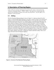
The <strong>Peel</strong> <strong>Watershed</strong> includes areas<br />
within the Northwest Territories<br />
• Gwich’in Land Use Plan in the NWT<br />
should be taken into account when<br />
planning within the Yukon<br />
• land and water use in the Yukon will have<br />
downstream effects and impacts<br />
• Opportunity to work together to plan for<br />
the whole watershed across political<br />
boundaries
Land ownership and Tetlit<br />
Gwich’in land and water use<br />
within the <strong>Watershed</strong><br />
• Land ownership and planning for Tetlit<br />
Gwich’in lands<br />
• Harvesting rights<br />
• Water quality and quantity
Cultural and Heritage Resources<br />
• Place names and extensive research on<br />
traditional use and heritage resources<br />
completed by GSCI<br />
• Provisions within Transboundary<br />
Agreement for Heritage Resources
Next Steps<br />
1. GLUP Board to respond to Draft ‘Precise<br />
Terms of Reference’<br />
2. Develop cooperative process/agreement for<br />
cooperative planning identifying:<br />
- Joint planning strategies<br />
- Joint planning activities<br />
- Information sharing arrangements
Thank you for this opportunity