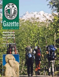
Summer 2007 - The Alpine Club of Canada
Summer 2007 - The Alpine Club of Canada
Summer 2007 - The Alpine Club of Canada

Create successful ePaper yourself
Turn your PDF publications into a flip-book with our unique Google optimized e-Paper software.
North Face Camp participants adapt to plans B thru Z<br />
BY MIKE WINGHAM AND BRYCE LEIGH<br />
<strong>The</strong> North Face – <strong>Alpine</strong> <strong>Club</strong> <strong>of</strong><br />
<strong>Canada</strong> Leadership Courses are<br />
designed to provide advanced<br />
training for the <strong>Club</strong>’s section trip leaders,<br />
General Mountaineering Camp amateur<br />
rope leaders, and national camp managers.<br />
Th e <strong>2007</strong> Winter Leadership Course was<br />
held at Vista Lodge in the Esplanade<br />
Range <strong>of</strong> the Selkirk Mountains, about<br />
50 kilometres northwest <strong>of</strong> Golden, BC.<br />
Topics covered included trip planning,<br />
group management, avalanche hazard<br />
evaluation and rescue techniques, route<br />
fi nding, emergency management and<br />
short-roping techniques for simple<br />
winter climbs. Our group consisted <strong>of</strong> 10<br />
students, three instructors and the camp<br />
cook. We came from Whistler in the<br />
west to Gaspé in the east, and points in<br />
between.<br />
Vista Lodge sits on a meadow next<br />
to a lake just above treeline at 2100<br />
metres. Th ere is tree skiing below and<br />
lots <strong>of</strong> alpine terrain above. Most <strong>of</strong><br />
the nearby peaks are accessible on skis<br />
or easily climbed on foot. Th e terrain is<br />
fairly complex, <strong>of</strong>f ering lots <strong>of</strong> learning<br />
opportunities for route-fi nding, avalanche<br />
hazard evaluation, group management<br />
and short-roping. A steep high col,<br />
aptly named “Col <strong>of</strong> the Wild”, accesses<br />
more terrain to the north. Th e only<br />
shortcoming is the absence <strong>of</strong> glaciers for<br />
glacier travel and crevasse rescue skills,<br />
but a small cliff near the Lodge worked<br />
admirably as a surrogate crevasse.<br />
We divided into three groups that<br />
rotated through responsibilities such as<br />
weather observations, water hauling and<br />
dish washing. Th e three instructors also<br />
took turns leading each <strong>of</strong> the groups on<br />
our daily ski trips. Th is allowed us to learn<br />
from all the instructors, each <strong>of</strong> whom<br />
had their unique skills and teaching style.<br />
Th e controlling factor <strong>of</strong> the week<br />
was the weather. Th e fi rst fi ve days were<br />
whiteouts, delivering snow, and more<br />
snow – about a metre in all. Th at was<br />
followed by two<br />
sunny days, but with<br />
temperatures around<br />
-25°C. We made<br />
the most <strong>of</strong> the<br />
whiteout days with<br />
classroom sessions<br />
every morning and<br />
evening, and practice<br />
sessions near the<br />
hut during the day.<br />
Th ere were a few<br />
trips further afi eld,<br />
but lack <strong>of</strong> visibility<br />
and the avalanche<br />
hazard kept us<br />
pretty conservative.<br />
Perhaps the most<br />
important lesson was<br />
adapting to the situation and preparing<br />
plans B-Z, as well as plan A.<br />
One <strong>of</strong> the best aspects <strong>of</strong> this course<br />
was the wealth and variety <strong>of</strong> experience<br />
<strong>of</strong> not only the instructors, but the<br />
participants as well. Everyone was able<br />
to learn something new from everyone<br />
else. Another was the realistic avalanche<br />
rescue scenario the instructors set up,<br />
with six burials at various depths on a<br />
steep slope. It tested not only our search<br />
skills, but also our ability to organize<br />
and coordinate a rescue party. Th ere is a<br />
tremendous diff erence between looking<br />
for a single transceiver buried under a few<br />
centimetres <strong>of</strong> snow in an open meadow,<br />
and searching, probing and digging out<br />
multiple packs buried up to two metres<br />
deep on a steep treed slope, some on top<br />
<strong>of</strong> each other.<br />
Skills and techniques are constantly<br />
evolving. We learned the latest in<br />
transceiver technology, the Avalanche<br />
Terrain Exposure Scale (ATES)<br />
system for classifying the exposure <strong>of</strong><br />
backcountry routes to avalanche hazard,<br />
and the Avaluator – a decision-making<br />
tool for trip planning and route fi nding in<br />
avalanche terrain.<br />
Th e culmination <strong>of</strong> the course was<br />
the last day, where each group was<br />
responsible for planning and carrying<br />
out a trip to a summit in Colpitti Basin.<br />
Th is was ‘uncharted territory’ for us, to<br />
the north <strong>of</strong> Col <strong>of</strong> the Wild. We had<br />
to make use <strong>of</strong> all we had learned so far:<br />
map reading, trip planning, avalanche<br />
hazard evaluation, group management,<br />
navigation, route fi nding, track setting<br />
and short-roping. Keeping everyone<br />
warm and well-fed was particularly<br />
important on that day as temperatures<br />
stayed well below -20°C.