Spatial Pattern of Socio-economic Landslide Vulnerability and its ...
Spatial Pattern of Socio-economic Landslide Vulnerability and its ...
Spatial Pattern of Socio-economic Landslide Vulnerability and its ...

You also want an ePaper? Increase the reach of your titles
YUMPU automatically turns print PDFs into web optimized ePapers that Google loves.
Since Kayangan Catchment form has unsymmetrical width, SD has not fitted to represent the directional<br />
deviation <strong>of</strong> socio-<strong>economic</strong> vulnerability. Directional distribution or St<strong>and</strong>ard Deviational Ellipse (SDE)<br />
was employed to measure directional deviation <strong>of</strong> socio-<strong>economic</strong> vulnerability. The calculation <strong>of</strong> SDE<br />
made the trend <strong>of</strong> socio-<strong>economic</strong> vulnerability distribution more clear. It pointed out that low vulnerability<br />
level had highest deviation along the major axis <strong>and</strong> covered flat area. Medium vulnerability level SDE had<br />
longer major axis than high vulnerability level. It indicated that high vulnerability level tend to be<br />
concentrated on the hilly area. This implied that slope had significant role on socio-<strong>economic</strong> vulnerability in<br />
Kayangan Catchment.<br />
Nr. <strong>of</strong> Settlement Block<br />
35<br />
30<br />
25<br />
20<br />
15<br />
10<br />
5<br />
0<br />
0 50 100 150 200 250 300 350<br />
Distance to Road<br />
Nr. <strong>of</strong> Settlement Block<br />
45<br />
40<br />
35<br />
30<br />
25<br />
20<br />
15<br />
10<br />
5<br />
0<br />
0 10 20 30 40 50 60<br />
Slope (Degree)<br />
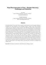
: Low <strong>Vulnerability</strong> : Medium <strong>Vulnerability</strong> : High <strong>Vulnerability</strong><br />
Figure 3 the <strong>Vulnerability</strong> Level based on number <strong>of</strong> settlement towards distance to road <strong>and</strong> Slope<br />
Furthermore, nearest neighbor analysis was employed to analyze the spatial pattern <strong>of</strong> socio<strong>economic</strong><br />
vulnerability. Nearest neighbor analysis <strong>of</strong> low, medium <strong>and</strong> high vulnerability level<br />
showed z-scores -4.52, -5.26 <strong>and</strong> -1.86 respectively. It implied that the spatial distribution <strong>of</strong> each<br />
level <strong>of</strong> vulnerability was clustered. Low level vulnerability household was clustered in more gentle<br />
area <strong>and</strong> high accessibility. However, low level vulnerability had higher tendency on deviation due<br />
to the high result <strong>of</strong> SD <strong>and</strong> SDE. In the other h<strong>and</strong> high level vulnerability household was clustered<br />
in the hilly <strong>and</strong> low degree <strong>of</strong> accessibility. Medium <strong>Vulnerability</strong> was also clustered in the hilly<br />
area but the accessibility is higher than low vulnerability level. Figure 3 showed the interlinked<br />
between vulnerability level <strong>and</strong> <strong>its</strong> environmental factor i.e. slope <strong>and</strong> accessibility (distance to<br />
road). Later, the trend <strong>of</strong> the interlinked between vulnerability level <strong>and</strong> <strong>its</strong> environmental was<br />
employed as an input <strong>of</strong> fuzzy membership in fuzzy logic technique.<br />
4.2. <strong>Spatial</strong> <strong>L<strong>and</strong>slide</strong> <strong>Vulnerability</strong> Prediction by means <strong>of</strong> Fuzzy Logic Technique<br />
<strong>Spatial</strong> pattern analysis with household survey described the distribution <strong>of</strong> socio-<strong>economic</strong><br />
vulnerability level in Kayangan Catchment quite well. However, the vulnerability level location<br />
obtained from household survey could not be described spatially on each settlement block due to<br />
the limitation <strong>of</strong> the samples. Fuzzy logic technique based on the slope <strong>and</strong> distance to road<br />
membership function was introduced to extrapolate vulnerability degree in each settlement block.<br />
Fuzzy membership function (Figure 3) <strong>and</strong> the fuzzy operator (Eqs. 1, 4 <strong>and</strong> 5) were generated<br />
to predict the socio-<strong>economic</strong> vulnerability level in Kayangan Catchment. It was computed for 6<br />
cases i.e. Fuzzy operator Or, Sum, Gamma 0.975, gamma 0.9, gamma 0.8 <strong>and</strong> gamma 0.7. The<br />
result <strong>of</strong> computation was mapped in order to interpret the spatial distribution <strong>of</strong> socio-<strong>economic</strong><br />
vulnerability in Kayangan Catchment. <strong>Socio</strong>-<strong>economic</strong> vulnerability map was represented by the<br />
possibility value between 0 <strong>and</strong> 1. The value <strong>of</strong> 0 indicated the full impossibility vulnerable <strong>and</strong> the<br />
value <strong>of</strong> 1 indicated the full possibility <strong>of</strong> being vulnerable. Thus, an area given as a value<br />
approaching 1 was indicated higher socio-<strong>economic</strong> vulnerability level. The final maps were<br />
presented in Figure 4 representing spatial distribution <strong>of</strong> socio-<strong>economic</strong> vulnerability level in<br />
Kayangan Catchment.<br />
7<br />
- 526 -