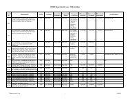
(ceres) validation plan monthly regional toa and surface ... - NASA
(ceres) validation plan monthly regional toa and surface ... - NASA
(ceres) validation plan monthly regional toa and surface ... - NASA

Create successful ePaper yourself
Turn your PDF publications into a flip-book with our unique Google optimized e-Paper software.
CERES Validation Plan - Subsystem 10.0 Release 4.0<br />
Spatial Averaging (TISA) working group for validating the SRBAVG data product. Section 10.3<br />
<strong>and</strong> 10.4 outline both pre-launch <strong>and</strong> post-launch <strong>validation</strong> studies. Section 10.5 provides details<br />
on implementing <strong>validation</strong> results in data production. A summary is given in Section 10.6.<br />
10.2 VALIDATION CRITERION<br />
10.2.1 Overall approach<br />
The science algorithms for TOA parameters are based on the ERBE-like technique (Subsystem<br />
3) <strong>and</strong> the new CERES geostationary-enhancement method (Subsystem 7). A few minor<br />
differences do exist. For example, the input data for this subsystem are derived from the SFC data<br />
product instead of the FSW. In addition, the data are sorted in terms of local time, not GMT. The<br />
first step in the averaging algorithms is to sort the FSW data in space <strong>and</strong> local time. The sorting<br />
of the gridded geostationary data is then done in a similar manner. Column-averaged cloud data<br />
are time interpolated to all local times using a linear technique. The complete time series of column-averaged<br />
data is used to compute <strong>monthly</strong> <strong>and</strong> <strong>monthly</strong>-hourly means. Monthly means of the<br />
Angular Model Scene Class data are computed using only data from the times of CERES observations.<br />
The temporal interpolation of total-sky LW <strong>and</strong> SW fluxes is identical to the technique<br />
described in Subsystem 3 (ERBE-like technique) <strong>and</strong> Subsystem 7 (new CERES geostationaryenhancement<br />
method). However, estimates of daily <strong>regional</strong> SW flux from the new CERES<br />
method are made only for days with at least one CERES observation. Only these days will be used<br />
in the calculation of new CERES geostationary enhanced <strong>monthly</strong> mean fluxes. Time interpolation<br />
of clear-sky LW <strong>and</strong> SW flux are done using ERBE-like method only. No attempt is made to<br />
produce clear-sky flux estimates at every hour. Only days with at least one clear-sky flux measurement<br />
are modeled <strong>and</strong> used in the computation of <strong>monthly</strong> means. Surface SW <strong>and</strong> LW fluxes are<br />
calculated based on TOA-to-<strong>surface</strong> parameterization schemes given in Subsystem 4.6 (CERES<br />
<strong>surface</strong> radiation budget technique) for every hour in which a TOA flux is calculated. Monthly,<br />
<strong>monthly</strong>-hourly, <strong>and</strong> daily means are computed in the same manner as used for TOA flux. Once<br />
<strong>regional</strong> means are computed for all parameters <strong>and</strong> all CERES 1-degree equal-angle gridded<br />
regions, these means are combined into zonal <strong>and</strong> global means using weighting factors to correct<br />
for variations in grid box size with latitude. There are three input data sets to this subsystem. They<br />
include hourly gridded single satellite CERES TOA <strong>and</strong> <strong>surface</strong> fluxes data set (SFC), atmospheric<br />
structure data set (ASTR), <strong>and</strong> gridded geostationary narrowb<strong>and</strong> radiances data set<br />
(GGEO). The output of the data processing system produces the <strong>monthly</strong> TOA <strong>and</strong> SRB averages<br />
data set (SRBAVG).<br />
The overall approach to validating the SRBAVG data product follows very closely to the<br />
method outlined in the <strong>validation</strong> <strong>plan</strong> for the ERBE-like data product (Subsystem 3) <strong>and</strong> will not<br />
be repeated here. Readers are referred to Subsystem 3 for more details.<br />
In order to conserve resources, the CERES TISA working group will not validate every data<br />
parameter listed in the SRBAVG science products. The data parameters used here for <strong>validation</strong><br />
purposes are 1) LW <strong>and</strong> SW TOA all-sky flux, 2) LW <strong>and</strong> SW TOA clear-sky flux, 3) LW <strong>and</strong> SW<br />
August 2000 2