Read the case study about Stonehenge. - Zoller+Fröhlich
Read the case study about Stonehenge. - Zoller+Fröhlich
Read the case study about Stonehenge. - Zoller+Fröhlich

Create successful ePaper yourself
Turn your PDF publications into a flip-book with our unique Google optimized e-Paper software.
How we build reality<br />
Case Study <strong>Stonehenge</strong> in High Definition<br />
Company Overview<br />
Z+F is one of world leading manufacturers of phase based laser<br />
scanners.<br />
Our strengths lie in our powerful 3D laser scanning hardware<br />
and software innovations which are considered to be <strong>the</strong> best<br />
on <strong>the</strong> market, <strong>the</strong> continual nature of <strong>the</strong>se innovations and<br />
<strong>the</strong> support that we show to our customers who are loyal and<br />
longstanding owing to <strong>the</strong> service we provide.<br />
In cooperation with <strong>the</strong> Greenhatch Group
Introduction<br />
<strong>Stonehenge</strong> is probably <strong>the</strong> most important<br />
prehistoric monument in <strong>the</strong> whole of Britain<br />
and has attracted visitors from earliest<br />
times. It stands as a timeless monument to<br />
<strong>the</strong> people who built it. <strong>Stonehenge</strong> is composed<br />
of earthworks surrounding a circular<br />
setting of large standing stones.<br />
English Heritage awarded a prestigious contract<br />
to Greenhatch Group based in Derby<br />
to create a detailed 3D laser scanning survey<br />
of <strong>the</strong> stones, both standing and fallen,<br />
and landscape immediately surrounding it<br />
within <strong>the</strong> area known as ‘ The Triangle ’.<br />
This was to use a combination of modern<br />
3D laser scanning and digital imaging technology<br />
in order to capture, in high resolution,<br />
<strong>the</strong> subtleties of both, <strong>the</strong> topography<br />
and <strong>the</strong> visible surfaces of <strong>the</strong> stones <strong>the</strong>mselves.<br />
The resultant data will be used alongside<br />
existing data sets created during <strong>the</strong> landscape<br />
research project to aid fur<strong>the</strong>r investigation<br />
and presentation of <strong>the</strong> WHS (World<br />
Heritage Site). It will also inform analysis of<br />
<strong>the</strong> stone surfaces <strong>the</strong>mselves, and any<br />
carvings upon <strong>the</strong>m, whilst providing <strong>the</strong><br />
basis for both structural monitoring and presentational<br />
displays on <strong>the</strong> monument.<br />
A combination of modern 3D laser scanning<br />
and digital imaging technology have been<br />
used by English Heritage to survey all <strong>the</strong><br />
stones that make up <strong>Stonehenge</strong> to produce<br />
<strong>the</strong> most accurate digital model ever for<br />
<strong>the</strong> world famous prehistoric monument.<br />
2
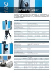
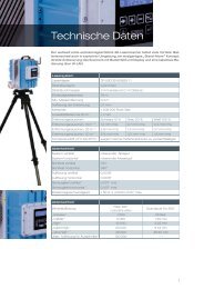
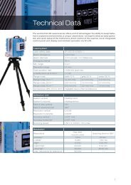
Z+F IMAGER ® 5010<br />
Floorplan of <strong>the</strong> site,<br />
revealing <strong>the</strong> stones both<br />
standing and fallen<br />
3
Objectives<br />
The objective is to carry out a detailed 3D<br />
laser scan survey of <strong>the</strong> following:<br />
The Triangle<br />
Topographic landscape within ‘ The Triangle<br />
’ – using terrestrial laser scanners<br />
and appropriate data processing techniques<br />
to accurately capture a ground<br />
surface model at a point-spacing ( resolution<br />
) of at least 10cm.<br />
The Stone Circle<br />
The stone circle and landscape immediately<br />
surrounding it – using Z+F 3D<br />
laser scanners and appropriate data processing<br />
techniques to accurately capture<br />
a surface model at a point-spacing<br />
of at least 2cm for <strong>the</strong> landscape and up<br />
to 1mm for <strong>the</strong> surfaces of <strong>the</strong> stones<br />
<strong>the</strong>mselves.<br />
The Stones<br />
The standing and fallen stones, including<br />
Station, Heel and Slaughter stones<br />
- using <strong>the</strong> close-range high-resolution<br />
IMAGER ® 5010 from Z+F, combined with<br />
appropriate data processing techniques, to<br />
accurately capture all visible faces of <strong>the</strong><br />
stones at a point-spacing of at least 0.5mm.<br />
4
<strong>Stonehenge</strong> Site<br />
(© Greenhatch Group)<br />
Despite <strong>the</strong> vast amount of archaeological<br />
activity and academic <strong>study</strong> into <strong>Stonehenge</strong><br />
and its landscape over <strong>the</strong> centuries,<br />
relatively little is known <strong>about</strong> <strong>the</strong> lichencovered<br />
surfaces of <strong>the</strong> sarsens and bluestones<br />
that make up <strong>the</strong> stone circle. The<br />
<strong>study</strong> served a number of purposes:<br />
It provides very precise base-line data to<br />
monitor <strong>the</strong> physical condition of <strong>the</strong> monument<br />
which is subjected to daily wea<strong>the</strong>ring.<br />
Digital data of this unprecedented level of<br />
detail on every single stone, <strong>the</strong>ir exact location<br />
in relation to each o<strong>the</strong>r and <strong>the</strong> precise<br />
way <strong>the</strong>y are lodged in <strong>the</strong> soil, will also be a<br />
valuable resource to anyone who is tasked<br />
with producing reconstruction models,<br />
drawings and computer generated images<br />
of <strong>the</strong> monument for public understanding<br />
and interpretation.<br />
Understanding of <strong>the</strong> known Neolithic “ dagger<br />
” and Bronze Age carvings as well as<br />
modern graffi ti carvings might also be enhanced,<br />
and new ones might be discovered.<br />
“The surfaces of <strong>the</strong> stones of <strong>Stonehenge</strong><br />
hold fascinating clues to <strong>the</strong> past. They are<br />
like manuscripts, a whole palimpsest of <strong>the</strong><br />
ideas, efforts and idiosyncrasies that marked<br />
<strong>the</strong> lives of people over millennia.”<br />
Dave Batchelor<br />
English Heritage’s<br />
<strong>Stonehenge</strong> Archaeologist<br />
5
Methodology<br />
Instruments and Software<br />
To provide data to English Heritage’s high<br />
specifi cation required <strong>the</strong> use of phased<br />
based scanners from Z+F. This allowed<br />
Greenhatch to capture data of <strong>the</strong> following :<br />
- Survey of stone circle structures and landscape<br />
immediately surrounding it using a<br />
Z+F IMAGER ® 5010 Laser Scanner & Z+F M-<br />
Cam in conjunction with a Total Station and<br />
Precise Control Field Targets with a resultant<br />
point-spacing of at least 2cm for <strong>the</strong> landscape<br />
and up to 1mm for <strong>the</strong> surfaces of <strong>the</strong><br />
stones <strong>the</strong>mselves.<br />
- Survey of <strong>the</strong> individual faces of standing<br />
and fallen stones, including Station, Heel<br />
and Slaughter stones using a high-resolution<br />
Z+F IMAGER ® 5010 laser scanner with<br />
enabled horizontal compensator in conjunction<br />
with a Total Station and Z+F Precise<br />
Control Field Targets with appropriate data<br />
processing techniques to accurately capture<br />
all visible faces of <strong>the</strong> stones at a pointspacing<br />
of at least 0.5mm.<br />
- Archaeological report on <strong>the</strong> assessment<br />
of any features which may have become<br />
visible or evident after data post processing,<br />
possibly warranting fur<strong>the</strong>r investigation.<br />
Why was laser scanning chosen<br />
The use of <strong>the</strong> very latest technology, in conjunction<br />
with approved registration techniques,<br />
will provide exceptionally high quality<br />
data sets. For instance, <strong>the</strong> picture on page<br />
8 and 9 is a perfect example of a selection of<br />
stones in colourised meshed model.<br />
In addition to this, <strong>the</strong> collected high resolution<br />
3D point cloud data collected, provides a<br />
snap shot in time of <strong>the</strong> site’s current condition<br />
and also an accurate archival reference<br />
for future comparison.<br />
6
A member of <strong>the</strong> Greenhatch Group<br />
using <strong>the</strong> Z+F IMAGER ® 5010<br />
Finally, <strong>the</strong> actual data quality collected is 50 %<br />
higher than <strong>the</strong> resolution currently able to be<br />
presented, allowing much higher levels of <strong>study</strong><br />
and presentation in <strong>the</strong> future.<br />
The Z+F IMAGER ® 5010 was used as it gave<br />
<strong>the</strong> team <strong>the</strong> ability to multi capture<br />
specifi c scene selections, thus reducing<br />
fi le sizes.<br />
Problems Encountered<br />
The Greenhatch team carried out a full<br />
breakdown of <strong>the</strong> methodology of <strong>the</strong> site<br />
working, before <strong>the</strong>y undertook <strong>the</strong> survey<br />
work. This enabled a smooth and effi cient<br />
working practice on site and eliminated<br />
many problems <strong>the</strong> team may have encountered.<br />
This allowed <strong>the</strong> site work being<br />
completed within <strong>the</strong> allocated timeframe.<br />
The main problems <strong>the</strong> Greenhatch Group<br />
encountered were with <strong>the</strong> offi ce processing<br />
of <strong>the</strong> data. The huge size of <strong>the</strong> data<br />
sets meant <strong>the</strong> process took longer than<br />
anticipated.<br />
In addition to this, when passing <strong>the</strong> data on<br />
to <strong>the</strong> archaeologist in <strong>the</strong> team <strong>the</strong>y could<br />
only view 10% of <strong>the</strong> data due to computer<br />
capabilities. This has lead to English Heritage<br />
requesting <strong>the</strong> data in various decimation<br />
levels to allow different levels of users to<br />
access <strong>the</strong> data.<br />
Finally, <strong>the</strong> original project brief was to model<br />
each complete stone face at 0.5 mm, but<br />
after discussions with English Heritage over<br />
<strong>the</strong> fi le size of <strong>the</strong> data, it was agreed to only<br />
model certain panels on significant stone<br />
faces, toge<strong>the</strong>r with a full archive set of XYZ<br />
fi les for each stone face. This data can <strong>the</strong>n<br />
be fully modelled at a later date with <strong>the</strong><br />
advancement of computer technologies.<br />
“For <strong>the</strong> scanning work at 0.5mm we used<br />
<strong>the</strong> 5010 and this was our first experience with<br />
this equipment but its ease of use and efficiency<br />
meant no interruptions in our site workflow.”<br />
Stuart Chadwick<br />
Greenhatch Group,<br />
Project Manager<br />
7
Deliverables<br />
The data for all three areas was registered<br />
toge<strong>the</strong>r onto <strong>the</strong> site control co-ordinates.<br />
This was <strong>the</strong>n exported in *.txt format<br />
to be used in <strong>the</strong> latest 3D modelling<br />
software. The site point cloud data was<br />
converted to a 3D mesh and <strong>the</strong> editing undertaken.<br />
Following on from this, <strong>the</strong> Greenhatch<br />
Group was able to create a complete mesh<br />
of <strong>the</strong> triangle area, <strong>the</strong> bank and ditch and<br />
<strong>the</strong>n each stone individually. The picture<br />
shows <strong>the</strong> complete meshed model of <strong>the</strong><br />
<strong>Stonehenge</strong> site created.<br />
With some of <strong>the</strong> larger stones consisting of<br />
nearly 40 million points, <strong>the</strong> fi nal mesh data<br />
needed to be decimated to a lower level<br />
to enable manipulation and modelling of<br />
<strong>the</strong> data. Using <strong>the</strong> 1mm stone mesh data,<br />
areas of signifi cant interest were highlighted<br />
by <strong>the</strong> project archaeologist and set panels<br />
were <strong>the</strong>n modelled using <strong>the</strong> 0.5mm data.<br />
Once <strong>the</strong> models had been completed <strong>the</strong><br />
data was exported in *.obj format (standard<br />
3D object fi le format) at various decimation<br />
levels due to <strong>the</strong> size of <strong>the</strong> fi nal fi les.<br />
Finally, <strong>the</strong> data collected at 0.5mm was exported<br />
in *.xyz format and issued for archiving.<br />
This data was unable to be modelled<br />
with current computer and software capabilities.<br />
But now archived, it can be used in<br />
<strong>the</strong> future with development of technology.<br />
All <strong>the</strong> scan data in *.xyz and *.obj format was<br />
issued toge<strong>the</strong>r with <strong>the</strong> Archaeological Report<br />
produced using <strong>the</strong> data which was undertaken<br />
by Archaeo-Environment Ltd.<br />
8
Example of <strong>Stonehenge</strong> Stone Circle, meshed model<br />
9
Pictures<br />
The Z+F IMAGER ® 5010 and a detailed view of its display..<br />
10
Also a Z+F IMAGER ® 5006 was used to scan <strong>Stonehenge</strong>.<br />
The Z+F IMAGER ® 5010 in <strong>the</strong> middle of <strong>the</strong> idyllic scenery of <strong>the</strong> <strong>Stonehenge</strong> area.<br />
11
Zoller + Fröhlich GmbH<br />
Simoniusstrasse 22<br />
88239 Wangen im Allgäu<br />
Germany<br />
Phone: +49 7522 9308-0<br />
Fax: +49 7522 9308-252<br />
www.zf-laser.com<br />
info@zf-laser.com<br />
08/2013