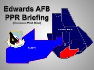
R-2508 - Edwards Air Force Base
R-2508 - Edwards Air Force Base
R-2508 - Edwards Air Force Base

Create successful ePaper yourself
Turn your PDF publications into a flip-book with our unique Google optimized e-Paper software.
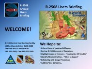
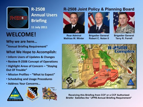
R-<strong>2508</strong><br />
Annual Users<br />
Briefing<br />
R-<strong>2508</strong> Joint Policy & Planning Board<br />
11 July 2011<br />
WELCOME!<br />
Why we are here…<br />
Rear Admiral<br />
Mathias W. Winter<br />
Brigadier General<br />
Robert C. Nolan II<br />
Brigadier General<br />
Terry R. Ferrell<br />
“Annual Briefing Requirement”<br />
What We Hope to Accomplish:<br />
• Inform Users of Updates & Changes<br />
• Review R-<strong>2508</strong> Concept of Operations<br />
• Highlight Areas of Concern – “Staying<br />
Out Of Trouble”<br />
• Mission Profiles – “What to Expect”<br />
• Scheduling and Usage Procedures<br />
• Address Your Concerns…<br />
Receiving this Briefing from CCF or a CCF Authorized<br />
Briefer Satisfies the “JPPB Annual Briefing Requirement”
R-<strong>2508</strong><br />
Annual<br />
Users<br />
Briefing<br />
Concept of Operations<br />
When the SUA is Activated<br />
• VFR<br />
• See and Avoid<br />
• Non-Exclusive Use<br />
• Transponder – Mode C<br />
• Accept Advisory Service<br />
• Active vs. Inactive Monitoring
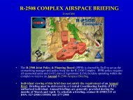
R-<strong>2508</strong><br />
Annual<br />
Users<br />
Briefing<br />
IFR Procedures<br />
Not Authorized when SUA is Active<br />
What to do if you encounter an<br />
IMC Condition…<br />
• Advise Joshua Approach<br />
• Expect IFR Clearance<br />
• On Top or Vectors to VMC<br />
• IFR Separation applied<br />
between IFR <strong>Air</strong>craft only
R-<strong>2508</strong><br />
Annual<br />
Users<br />
Briefing<br />
R-<strong>2508</strong> <strong>Air</strong> Traffic Control (ATC) and<br />
Military Radar Unit (MRU) Services<br />
• High Desert TRACON, “Joshua Approach”<br />
- Traffic & boundary calls, mission support<br />
- VFR and IFR Services as applicable within<br />
MOAs, ATCAAs, R-<strong>2508</strong>, and Released<br />
Internal Restricted Areas<br />
• SPORT MRU, “SPORT” Traffic & boundary calls,<br />
mission support services in R-2515<br />
• <strong>Air</strong>space Surveillance Center MRU (ASC)<br />
“China Control” - Traffic & boundary calls, mission<br />
support services in R-2505, R-2506 & R2524<br />
• Desert Radio, Non-Radar services and mission<br />
support in R-2502N, R-2502E & R-2502A
R-<strong>2508</strong><br />
Annual<br />
Users<br />
Briefing<br />
Rapidly Maneuvering<br />
<strong>Air</strong>craft<br />
When able “Advise Joshua” when<br />
conducting rapid heading or<br />
altitude changes…<br />
• ATC traffic calls are based on observed aircraft<br />
positions, headings, altitudes and radar limitations<br />
• Rapid changes in heading or altitude may not be<br />
observed by ATC in time for the information to be<br />
issued in a timely manner<br />
• When able, aircrews are encouraged to alert ATC when<br />
their flight profile will include rapid heading and/or<br />
altitude changes<br />
• Example: "Joshua, Hawk 11 flight maneuvering FL250<br />
to one five thousand"
R-<strong>2508</strong><br />
Annual<br />
Users<br />
Briefing<br />
Restricted Areas:<br />
R-<strong>2508</strong><br />
FL200 - UNLTD<br />
• Schedule R-<strong>2508</strong> with CCF<br />
• Schedule Internal Restricted Areas<br />
with Using Agency and CCF To<br />
Transit MOA/ATCAA <strong>Air</strong>space<br />
R-2505<br />
SFC-UNLTD<br />
NAWCWD<br />
Using Agencies:<br />
R-2505, R-2506, R-2524: NAWCWD<br />
R-2515: AFFTC (ROC)<br />
R-2502N, R2502E, R-2502A: NTC<br />
R-2506<br />
SFC - 6,000 MSL<br />
NAWCWD<br />
R-2524<br />
SFC-UNLTD<br />
NAWCWD<br />
R-2502N<br />
SFC-UNLTD<br />
NTC<br />
R-2515<br />
SFC-UNLTD<br />
AFFTC<br />
R-2502E<br />
SFC – UNLTD<br />
NTC<br />
R-2502A<br />
SFC To<br />
16,000 MSL<br />
NTC
R-<strong>2508</strong><br />
Annual<br />
Users<br />
Briefing<br />
MOA & ATCAA <strong>Air</strong>space<br />
Military Operations Areas & <strong>Air</strong> Traffic<br />
Control Assigned <strong>Air</strong>space<br />
JOSHUA APPROACH<br />
Frequencies:<br />
Isabella : 335.6/134.05<br />
348.7/133.65<br />
Owens: 322.3/126.55<br />
Saline: 256.8 123.95<br />
Panamint: 291.6/120.25<br />
PORTERVILLE<br />
& BAKERSFIELD<br />
Floor 2000 AGL<br />
Scheduled Intermittent<br />
by NOTAM Only<br />
BISHOP MOA<br />
Owens ATCAA Above<br />
200AGL - FL180<br />
OWENS<br />
MOA-ATCAA<br />
Floor 200 AGL<br />
ISABELLA<br />
MOA-ATCAA<br />
Floor 200 AGL<br />
SALINE<br />
MOA-ATCAA<br />
Floor 200 AGL<br />
DEEP SPRINGS ATCAA<br />
Requires Prior Coordination<br />
FL240 to FL600<br />
SHOSHONE MOA-ATCAA<br />
Remains Under ZLA Control<br />
Until Requested by Pilot<br />
PANAMINT<br />
MOA-ATCAA<br />
Floor 200 AGL<br />
SHOSHONE<br />
NORTH<br />
Floor 200 AGL<br />
SHOSHONE<br />
SOUTH<br />
Floor 200 AGL<br />
BUCKHORN<br />
MOA-ATCAA<br />
Floor 200 AGL<br />
BARSTOW EAST & WEST<br />
MOA-ATCAA<br />
Floor 200 AGL
R-<strong>2508</strong><br />
Annual<br />
Users<br />
Briefing<br />
Overflight<br />
Restrictions of Parks<br />
& Wilderness Areas<br />
Kings Canyon<br />
& Sequoia<br />
National Parks<br />
John Muir<br />
Wilderness Area<br />
Death Valley<br />
National Park<br />
Staying out of trouble…<br />
Floor of MOA over National Parks<br />
and Wilderness Areas 3,000 AGL<br />
• FLIP AP1 California<br />
• FAA JO 7400.8<br />
Domeland<br />
Wilderness<br />
Area<br />
Remain at least 3,000 feet both Laterally and Vertically<br />
from National Parks and Wilderness Areas…<br />
3,000 feet from Canyon Walls and Saddles
R-<strong>2508</strong><br />
Annual<br />
Users<br />
Briefing<br />
• Sequoia and Kings Canyon<br />
National Parks (SEKI)<br />
o All participating aircrews maintain an<br />
altitude of FL180 or above over SEKI<br />
unless specifically scheduled lower<br />
through CCF.<br />
• Annotate “SEKI” in Remarks Section of<br />
R-<strong>2508</strong> Complex <strong>Air</strong>space request Form.<br />
o Unscheduled operations below FL180<br />
over SEKI are authorized only for safety<br />
of flight considerations.<br />
Staying out of trouble…<br />
o At no time will any participating aircraft<br />
descend below 3,000 ft AGL within the<br />
boundaries of SEKI except in an<br />
emergency situation. Lateral separation<br />
from SEKI is 3000 feet.
R-<strong>2508</strong><br />
Annual<br />
Users<br />
Briefing<br />
Noise Sensitive Areas<br />
Staying out of trouble…<br />
Cartago<br />
Independence<br />
Lone Pine<br />
Keeler<br />
All communities within the R-<strong>2508</strong><br />
Complex are considered “noise<br />
sensitive areas”. Noise sensitive<br />
areas must be avoided by 3000’<br />
AGL. The only exception to the<br />
3000’ restriction is while operating<br />
on an approved test plan.<br />
Olancha<br />
Lake Isabella
R-<strong>2508</strong><br />
Annual<br />
Users<br />
Briefing<br />
Sonic Boom & Low<br />
Level Complaints<br />
Areas of Highest<br />
Concern… Lake Isabella,<br />
Bodfish & Kernville<br />
Staying out of trouble…
R-<strong>2508</strong><br />
Annual<br />
Users<br />
Briefing<br />
Sonic Boom & Low<br />
Level Complaints<br />
Areas of Highest<br />
Concern… Keeler<br />
Staying out of trouble…
R-<strong>2508</strong><br />
Annual<br />
Users<br />
Briefing<br />
Sonic Boom & Low<br />
Level Complaints<br />
Areas of Highest<br />
Concern… Lone Pine<br />
Staying out of trouble…
R-<strong>2508</strong><br />
Annual<br />
Users<br />
Briefing<br />
Overflight Restrictions<br />
• Published Civil <strong>Air</strong>ports:<br />
1,500’AGL or 3 NM<br />
• Mojave <strong>Air</strong> & Space Port Class D <strong>Air</strong>space:<br />
4,800’ MSL and below<br />
- National Test Pilot’s School<br />
- <strong>Air</strong>craft & Space Systems development, testing<br />
& modifications<br />
- <strong>Air</strong>borne Tow operations<br />
• Community Overflights: 3,000’ AGL unless<br />
operating on an approved test plan<br />
• Temporary Flight Restrictions (TFRs)<br />
- Land Management Activity<br />
- Fire-fighting Support <strong>Air</strong>craft
R-<strong>2508</strong><br />
Annual<br />
Users<br />
Briefing<br />
TFR Incursions<br />
Staying out of trouble…<br />
SMOKE FROM FIRES - STAY AWAY!<br />
Check NOTAMS Prior to Step<br />
Check R-<strong>2508</strong> Daily Brief Sheet
Skull Corner…<br />
R-<strong>2508</strong><br />
Annual<br />
Users<br />
Briefing<br />
• Used by the AFFTC for ACBT<br />
• Eastern half of Panamint MOA and<br />
ATCAA, Shoshone MOA and<br />
Shoshone North ATCAA from 200’<br />
AGL to FL 500<br />
• Only one AFFTC user scheduled for<br />
Skull Corner at any one time.<br />
• Shoshone airspace released to ZLA<br />
until the ACBT flight is airborne and<br />
requests activation.<br />
• Skull Corner Cap Points are -<br />
Furnace: 36°11’27”N 116°39’51”W,<br />
Dunes: 35°40’.59”N 116°13’ 10”W<br />
Dumont Dunes<br />
Furnace Peak
R-<strong>2508</strong><br />
Annual<br />
Users<br />
Briefing<br />
R<strong>2508</strong> Caps Points<br />
Owens<br />
Saline<br />
Death<br />
(Deconfliction Caps)<br />
Pine<br />
• Owens: 37° 05’N 118° 15’W to 36° 20’N 117° 55’W<br />
• Pine: 36° 35.00’N 118° 03.00’W Hold Northwest<br />
between Lone Pine and Independence at 21K or ATO<br />
• Saline: 37° 05’N 117° 55’W to 36° 30’N 117° 30’W<br />
• Death: 36° 55’N 117° 20’W to 36° 25’N 117° 05’W<br />
Panamint<br />
Bangor<br />
• Panamint: 36° 25’N 117° 25’W to 35° 55’N 117° 00’W<br />
• Gate: 35° 48.80’N 116° 53.19’W Hold West, 15 Mile<br />
Legs, Left Turns, 15K to 19K or ATO<br />
• Skull: 36° 11’N 116° 40’W to 35° 41’N 116° 13’W<br />
• Bangor/ARBNG: 35° 39.35’N 116° 16.30’W Hold<br />
Northwest 15 Mile Legs, Left Turns, 15K to 19K (primary<br />
block), 5K to 9K (low block) or ATO. Alternate AR Cap<br />
Gate<br />
Skull
R-<strong>2508</strong><br />
Annual<br />
Users<br />
Briefing<br />
NAS Lemoore/Fresno ANG<br />
Ingress/Egress Routes<br />
• NAS Lemoore<br />
• Entry/Exit via Kiote & Swoop<br />
• Use SWOOP to avoid Cap Points<br />
when active<br />
• Fresno ANG<br />
• Entry/Exit via FAANG & MITEL<br />
• Use FAANG to avoid Cap Points<br />
when active<br />
• Other Uses<br />
• Be aware of heavy East/West<br />
traffic flow across Owen Valley<br />
• Avoid Mt Whitney area<br />
Owens Cap<br />
FAANG<br />
MITEL<br />
KIOTE<br />
SWOOP<br />
ROMOF<br />
Mt Whitney<br />
Saline Cap<br />
Pine Cap
R-<strong>2508</strong><br />
Annual<br />
Users<br />
Briefing<br />
Tucky<br />
Green Flag West…<br />
• IFR Routing… Enter/Exit via<br />
TUCKY – BTY 209/18<br />
• VFR Routing… Enter/Exit via<br />
Eagle Mountain<br />
• Primary Refueling Area Coaldale<br />
(AROAL) 22K’<br />
• Alternate Refueling Area Bangor<br />
22K’<br />
• Lone Pine CAS Orbit Hold at<br />
21K’ then operate 20K’ to 200<br />
AGL in Owens MOA/ATCAA<br />
CP Pine<br />
AROAL<br />
CP Gate<br />
Julie<br />
Eagle Mt<br />
CP Bangor<br />
AR Bangor<br />
(ARBNG)
R-<strong>2508</strong><br />
Annual<br />
Users<br />
Briefing<br />
Complex Common - 256.275 MHz<br />
• Used as a Unicom for “airborne airspace<br />
coordination and deconfliction”.<br />
• <strong>Air</strong>crews may request Joshua have<br />
desired aircraft “Come Up Complex Common”<br />
• <strong>Air</strong>crews request off frequency (if necessary)<br />
with Joshua before switching to Complex Common.<br />
• Once coordination/deconfliction is completed,<br />
report back up on Joshua frequency.<br />
• Not to be used as a discrete mission or inter-flight<br />
frequency."<br />
• Not monitored by Joshua, China Control, SPORT,<br />
or Desert Radio.
R-<strong>2508</strong><br />
Annual<br />
Users<br />
Briefing<br />
Special Activity Areas…<br />
Weather Areas<br />
Area 1: Eastern Half of R-2515 Divided by<br />
Highway 395<br />
Area 2: Western Half of R-2515 Divided by<br />
Highway 395<br />
Area 3: Isabella MOA/ATCAA West of the<br />
PMD 330° Radial<br />
Area 4: Panamint MOA/ATCAA East of the<br />
BTY 182° Radial<br />
Area 5: R-2515 South of the FIM 049°<br />
Radial & Barstow MOA/ATCAA<br />
3<br />
1<br />
5<br />
What Users need to know…<br />
2<br />
Highway 395<br />
NID 152° Radial<br />
• WX Areas exist in the Southern Portion of the Complex<br />
• WX Areas are Released to ZLA for <strong>Air</strong> Carrier WX Avoidance<br />
• Joshua/SPORT will keep users updated on areas activated<br />
• If you’re unfamiliar with WX Area locations advise Joshua<br />
or SPORT and request assistance in WX Area avoidance.<br />
4
R-<strong>2508</strong><br />
Annual<br />
Users<br />
Briefing<br />
Special Activity<br />
Areas<br />
Inyo-Kern Transition Area<br />
Joshua/SPORT Phraseology: ITA<br />
• Hours: 1100–1300 and 1700–0700<br />
Local Time<br />
• All complex clearances Exclude the<br />
ITA during above hours<br />
• <strong>Air</strong>crews may request clearance to<br />
transit/operate in area at any time<br />
Red Rock 11,999 MSL<br />
To 6,001<br />
Windmill 11,999 MSL<br />
To 7,001<br />
Bridge 11,999 MSL To<br />
Surface
R-<strong>2508</strong><br />
Annual<br />
Users<br />
Briefing<br />
Special Activity Areas<br />
• Trona Controlled Firing Area - CFA<br />
• Altitudes: 3,000 AGL to 20,000 MSL<br />
• Used to Protect Path of Free Flight<br />
Weapons Across Trona Gap<br />
Trona CFA<br />
• Trona Corridor<br />
• Altitudes: 20,000’ MSL to Infinity<br />
• Used to Protect Path of Free Flight<br />
Weapons Across Trona Gap<br />
• Used For UAS/RPA Transitions<br />
• May Be Used in Conjunction With Trona<br />
Controlled Firing Area – CFA<br />
Trona Corridor
R-<strong>2508</strong><br />
Annual<br />
Users<br />
Briefing<br />
Special Activity Areas<br />
• CR Briggs Mine – Blasting<br />
• Flying Rock to Unknown Altitudes<br />
• Blasting Times – Unless otherwise<br />
coordinated, 1100-1230L and<br />
1600-1730L Daily<br />
• Avoid when flying low level in<br />
southern Panamint Valley
R-<strong>2508</strong><br />
Annual<br />
Users<br />
Briefing<br />
Special Activity Areas<br />
NASA Goldstone Facility<br />
• Overflight Restriction<br />
• 15,000 MSL or Higher as Scheduled<br />
• Goldstone provides ATC/MRU with<br />
radiation map to identify affected<br />
area, altitudes, and times when 70<br />
meter dish is radiating<br />
• Joshua, SPORT, China Control and<br />
Desert Radio will advise Users of<br />
Affected Areas
R-<strong>2508</strong><br />
Annual<br />
Users<br />
Briefing<br />
Coaldale<br />
AROAL<br />
Special Activity Areas<br />
<strong>Air</strong>-Refueling Operations<br />
Refueling Areas within the Complex are:<br />
• ARISB: PMD 345/35 to 70 Left Turns<br />
Shoshone<br />
ARSHN<br />
• AROAL: OAL 155/60 to 90, Left Turns<br />
• ARSHN: BTY 150/60 to 40, Left Turns<br />
• ARBNG: Left hand turns between<br />
36.05N 116.24W to 36.00N 116.31W to<br />
35.49N 116.19W to 35.53N 116.12W,<br />
Left Turns (Green Flag West Only)<br />
• EDW Modified: EDW 068/9 to 34,<br />
Left Turns (R-2515 Test Missions)<br />
Isabella<br />
ARISB<br />
EDW Modified<br />
Bangor<br />
ARBNG
R-<strong>2508</strong><br />
Annual<br />
Users<br />
Briefing<br />
Special Activity Areas<br />
• Mojave <strong>Air</strong> & Space Port:<br />
Experimental aircraft & rocket Research,<br />
development, Test & Evaluation activity,<br />
<strong>Air</strong>craft refitting, NTPS<br />
• Class D: Surface to 4,800 MSL<br />
• Launch Altitudes: Surface to Infinity<br />
• Joshua will advise of launch activity<br />
• Koehn Dry Lake: Amateur Rocket<br />
Launch activity.<br />
• Launch Altitudes to 50,000’ MSL<br />
• Safety observers provided<br />
• Wave Camp Area: Concentrated<br />
Glider Activity - All altitudes<br />
• Transponder Equipped above FL180<br />
Wave Camp Area<br />
Surface & Above<br />
Mojave<br />
<strong>Air</strong> & Space Port<br />
Surface to Unlimited<br />
Koehn Launch Site<br />
Surface to 50,000’MSL
R-<strong>2508</strong><br />
Annual<br />
Users<br />
Briefing<br />
Special Activity Areas<br />
• Supersonic Areas<br />
• Black Mountain Supersonic<br />
• Tiered Bottom<br />
• SPORT must be open<br />
• High Altitude Supersonic<br />
• At or Above FL300<br />
• Entry/Exit 1 within R-2515<br />
- Avoid Daggett Shelf<br />
• Other Entry/Exit Point usage<br />
Requires Prior Coordination<br />
with SPORT and Center<br />
Supersonic operations<br />
•Only in authorized supersonic areas<br />
• Refer to R-2515 in-flight procedures (AFFTCI 11-1/11-100)<br />
regarding use of High Altitude and Black Mountain areas<br />
additional information available through the <strong>Edwards</strong><br />
<strong>Air</strong>space Management Office DSN 527-2446 or 527-4453<br />
• Schedule Supersonic Operations with AFFTC Resource<br />
Operations Center (ROC) Same Day: DSN 527-3940 next day<br />
or beyond DSN 527-4110
R-<strong>2508</strong><br />
Annual<br />
Users<br />
Briefing<br />
TUCKY<br />
BTY 209/18<br />
UAS/RPA Transition Routes<br />
INS<br />
• INS..TUCKY..R2502<br />
• INS..TUCKY..Trona <strong>Air</strong>port<br />
• From Trona <strong>Air</strong>port<br />
Transition to R2505, R2524,<br />
R2515, 99CL, or 04CA<br />
• All Transitions flown at FL190<br />
or FL200 Correct Altitude for<br />
Direction of Flight<br />
Trona <strong>Air</strong>port<br />
NID 052/19<br />
Way Point<br />
NID 123/16<br />
04CA<br />
99CL
R-<strong>2508</strong><br />
Annual<br />
Users<br />
Briefing<br />
Chaff & Flares<br />
Chaff/ECM<br />
• Requires specific frequency<br />
management approvals (usually via unit)<br />
• Notify CCF of Chaff/ECM activity when<br />
scheduling airspace (remarks section)<br />
• Additional (internal) range rules may<br />
apply<br />
Flares<br />
• Internal restricted areas ONLY & requires<br />
specific Using Agency approval
R-<strong>2508</strong><br />
Annual<br />
Users<br />
Briefing<br />
Low Level Procedures<br />
• For sustained flight below 1,500’ AGL<br />
• Requires notification/check-in with<br />
JOSHUA Approach<br />
• Operating frequency - 315.9 MHz, NOT<br />
Monitored by ATC/MRU<br />
• Use as Unicom for blind transmissions,<br />
pilot to pilot only<br />
• State Call sign, type aircraft, location<br />
and intentions<br />
• Provides cross frequency<br />
communication capability with Land<br />
Management Agencies
R-<strong>2508</strong><br />
Annual<br />
Users<br />
Briefing<br />
GEO Reference Points<br />
• Easily identifiable ground<br />
reference points used to describe<br />
aircraft position during low level<br />
flight operations on frequency<br />
315.9<br />
• Detailed list of these locations,<br />
names and latitude/longitude<br />
position listed in R<strong>2508</strong> Users<br />
Handbook paragraph 5.1.3
Sidewinder<br />
Low Level with JEDI transition<br />
R-<strong>2508</strong><br />
Annual<br />
Users<br />
Briefing<br />
• All points must be flown in a<br />
clockwise direction,<br />
sequentially i.e. A, B, C… M, or<br />
C, D, E… O, etc. Opposite<br />
Direction Flight Prohibited<br />
• Preferred alternate entry via<br />
points C or E<br />
• JEDI Transition: Proceed East<br />
from Point C to Point J<br />
• Annotate “Sidewinder” in<br />
remarks section of R-<strong>2508</strong><br />
<strong>Air</strong>space Request Form.<br />
Route Map, Route<br />
Description, and Standard<br />
Operating Procedures<br />
Published in<br />
R-<strong>2508</strong> User Handbook<br />
and AFFTCI 11-1/11-100
Lights Out &<br />
R-<strong>2508</strong><br />
Annual<br />
Users<br />
Briefing<br />
Targets of Opportunity<br />
Lights-Out Operations<br />
• May be conducted within internal<br />
restricted areas<br />
• Within R-<strong>2508</strong> IAW Unit/CCB LOP<br />
Do Not Select Targets of Opportunity<br />
• Highlighting test aircraft may result in a<br />
security violation or interruption of an<br />
expensive test
R-<strong>2508</strong><br />
Annual<br />
Users<br />
Briefing<br />
R-<strong>2508</strong> Complex Daily<br />
Brief Sheet<br />
• What’s going on the next day<br />
• UAS Transitions<br />
• Unusual/Special Operations<br />
• Future Operations
R-<strong>2508</strong><br />
Annual<br />
Users<br />
Briefing<br />
IFR Flight Planning<br />
• Flight Plans should be filed<br />
with 2 separate legs…<br />
• Leg 1: Departure point, route of flight,<br />
R-<strong>2508</strong> entry point, R-<strong>2508</strong> as destination.<br />
• Leg 2: R-<strong>2508</strong>, R-<strong>2508</strong> exit point, flight route,<br />
destination airport/fix<br />
• Do not file a delay in the Complex<br />
• Filing a delay may result in the loss of the<br />
second half of your flight plan<br />
• May result in extensive delay in receiving IFR<br />
Clearance out of area
R-<strong>2508</strong><br />
Annual<br />
Users<br />
Briefing<br />
Entry/Exit Points<br />
Flight Plan Entries…<br />
• Use Complex entry/exit points<br />
during flight planning to alert<br />
Joshua/Center of your<br />
intentions.<br />
*NID TACAN is unmonitored when China<br />
Lake airfield is closed.
R-<strong>2508</strong><br />
Annual<br />
Users<br />
Briefing<br />
Pancho 2<br />
Complex Clearances<br />
SAGE 2: Isabella, Owens, Saline, and<br />
Panamint, FL290 and below<br />
PANCHO 2: Clearance to operate within<br />
Isabella and Panamint work areas at and<br />
below FL500, and Owens and Saline<br />
work areas at and below FL290… Only<br />
EDW, NID, and PMD based aircraft are<br />
authorized a PANCHO 2<br />
WAR 2 Clearance: Clearance to operate<br />
in the Saline and Panamint Work Areas<br />
at and below FL290, Shoshone MOA,<br />
and Shoshone North and South ATCAA's<br />
at and belowFL230.<br />
Sage 2<br />
War 2
R-<strong>2508</strong><br />
Annual<br />
Users<br />
Briefing<br />
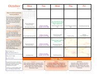
R-<strong>2508</strong> Scheduling<br />
CCF Office Hours - Monday thru Friday<br />
0600-1800L, excluding holidays<br />
• Schedule NLT 1600L Day Prior<br />
• Schedule NLT 1600L Friday for Weekend<br />
Operations<br />
• After hours schedule changes: Call CCF<br />
After Hours Number 1-866-805-2851<br />
• Used for changes to previously<br />
scheduled missions
R-<strong>2508</strong><br />
Annual<br />
Users<br />
Briefing<br />
Scheduling<br />
Why CCF Needs your <strong>Air</strong>space<br />
Request Form NLT 1600L Day<br />
Prior (Friday for Weekends)<br />
<strong>Air</strong>space Activation, Release and<br />
Recall Information is sent to<br />
Los Angeles Center NLT 1700L<br />
Late scheduling could result in<br />
Mission Loss or Delay
Scheduling<br />
R-<strong>2508</strong><br />
Annual<br />
Users<br />
Briefing<br />
• Scheduling data used to Generate<br />
ATC Flight Plan Information and<br />
Flight Progress Strip for Joshua<br />
• Flight Strip is Your Ticket for<br />
entry into the Complex<br />
• Use R-<strong>2508</strong> Complex <strong>Air</strong>space Request<br />
Form and Submit via Fax or Email<br />
• Units will receive return acknowledgement<br />
• Changes to received schedules MUST be<br />
called in, emailed, or Faxed to CCF<br />
• Include internal restricted areas as<br />
scheduled with Using Agency
R-<strong>2508</strong><br />
Annual<br />
Users<br />
Briefing<br />
What’s Available<br />
Online…<br />
• R-<strong>2508</strong> Daily Flying Schedule posted<br />
online Monday Thru Friday at 0700L<br />
• Includes Work Areas and Mission<br />
Profiles as provided by on R-<strong>2508</strong><br />
<strong>Air</strong>space Request Form<br />
• Access requires .mil email address<br />
and CAC log on<br />
• https://afkm.wpafb.af.mil/community/views/home.aspxFilter=MC-OP-00-08
What’s Available<br />
Online…<br />
• Users Handbook<br />
• This Briefing<br />
R-<strong>2508</strong><br />
Annual<br />
Users<br />
Briefing<br />
• <strong>Air</strong>space Request Form<br />
• Situation Report (SITREP)<br />
• Pilot Guide & Map<br />
• NID Transient Pilot Brief<br />
• Where<br />
http://www.edwards.af.mil/r-<strong>2508</strong>.asp
R-<strong>2508</strong><br />
Annual<br />
Users<br />
Briefing<br />
SITREP<br />
(R-<strong>2508</strong> Situation Report)<br />
• Official Communication<br />
• Official Response<br />
• Don’t wait too long…
R-<strong>2508</strong><br />
Annual<br />
Users<br />
Briefing<br />
R-<strong>2508</strong> Central Coordinating Facility<br />
Questions<br />
• Co-Located with Joshua Approach<br />
• Here to Support your Operations<br />
– DSN 527-<strong>2508</strong> or Commercial 661-277-<strong>2508</strong><br />
– FAX 527-4798 or Commercial 661-277-4798<br />
– <strong>2508</strong>ccf@edwards.af.mil<br />
– Online Information<br />
• http://www.edwards.af.mil/r-<strong>2508</strong>.asp<br />
• https://afkm.wpafb.af.mil/community/views/home.aspxFilter=MC-OP-00-08