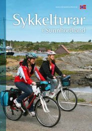
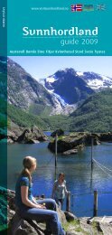
Browse the brochure - Visit Sunnhordland
Browse the brochure - Visit Sunnhordland
Browse the brochure - Visit Sunnhordland

You also want an ePaper? Increase the reach of your titles
YUMPU automatically turns print PDFs into web optimized ePapers that Google loves.
Turforslag - Tysnes Trip suggestions - Tysnes 25<br />
Taking a break near Uggdal Church<br />
Flatråkervassdraget river (31 km)<br />
The cycling trip to Flatråkervassdraget starts in <strong>the</strong><br />
coastal village of Våge and takes you through wooded<br />
areas and along sparkling lakes.<br />
Våge<br />
You cycle through short avenues of sweet-scented pine trees and through huddled<br />
farm clusters with buildings right by <strong>the</strong> road. Every turn in <strong>the</strong> road and every<br />
plain will tempt you to stop and enjoy <strong>the</strong> picturesque scene and <strong>the</strong> peace and<br />
quiet. You will more or less have <strong>the</strong> road all to yourself. Grazing animals, <strong>the</strong> wind<br />
blowing though <strong>the</strong> treetops and <strong>the</strong> noise of your wheels on <strong>the</strong> tarmac are <strong>the</strong><br />
only sounds you’ll hear.<br />
Færavåg<br />
Uggdal<br />
Uggdalseidet<br />
Starts at <strong>the</strong> ferry quay at Våge. After about 350 metres, turn right at <strong>the</strong> crossroads<br />
on <strong>the</strong> Rv 49 road towards Hodnanes and Stord. Follow <strong>the</strong> Rv 49 road south<br />
to Flatråker, where you come to a crossroads that will take you east along <strong>the</strong><br />
Flatråkervassdraget river. At this point, you will have cycled 13.4 km. You follow<br />
<strong>the</strong> only tarmac road along <strong>the</strong> river. You pass Midtvatnet lake and <strong>the</strong>n come to<br />
Nordbustadvatnet lake after a while, where you cycle along <strong>the</strong> east side. The road<br />
now climbs approx. 71 metres up to an altitude of 144 metres. From here, <strong>the</strong>re are<br />
excellent views of Nordbustadvatnet lake and down <strong>the</strong> valley.<br />
Flatråker<br />
200m<br />
After a fur<strong>the</strong>r 8.2 km, you return to <strong>the</strong> Rv 49 road at Holma, where you turn right<br />
at <strong>the</strong> crossroads and follow <strong>the</strong> Rv road back to your starting point at Våge. On this<br />
stretch of <strong>the</strong> route, you pass <strong>the</strong> municipal centre Uggdal where you can take a<br />
detour down to <strong>the</strong> bathing spot at Kjevikjo to cool down.<br />
The route has a total length of 31.24 km and a total altitude difference of<br />
509 metres. The highest point on <strong>the</strong> route is 144 metres, which you come<br />
to after 21 km.<br />
0m 6km 12km 18km 24km 30km<br />
Difficulty level: Medium<br />
Length: 31 km<br />
Surface: Tarmac<br />
Max. altitude: 144 m<br />
0m