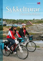
Browse the brochure - Visit Sunnhordland
Browse the brochure - Visit Sunnhordland
Browse the brochure - Visit Sunnhordland

You also want an ePaper? Increase the reach of your titles
YUMPU automatically turns print PDFs into web optimized ePapers that Google loves.
Rødspollen, Sveio<br />
Trip suggestions - Sveio<br />
19<br />
Round trip Ålfjord (32,5 km)<br />
The route starts on <strong>the</strong> bike path along <strong>the</strong> main road<br />
and continues through peaceful forests and farmland<br />
with many gems along Ålfjorden. If you’d like, you can<br />
make a detour into <strong>the</strong> village in Førde, or go for a swim<br />
in Selsåsvika.<br />
Førde<br />
Selsåsvika<br />
Where <strong>the</strong> road from <strong>the</strong> Golf-park meets <strong>the</strong> road to <strong>the</strong> village, turn left and ride<br />
on <strong>the</strong> pedestrian-/cycle-track northwards alongside <strong>the</strong> Route 47. You have to cross<br />
to <strong>the</strong> right-hand side at Bjelland, and ride in <strong>the</strong> underpass at <strong>the</strong> intersection,<br />
continuing now alongside <strong>the</strong> highway E39. Pass Haukås service-station. After Rød, at<br />
Drange, <strong>the</strong> cycle-path stops, you have to ride on <strong>the</strong> road 1 km, and <strong>the</strong>re can be a<br />
lot of traffic. On <strong>the</strong> left turn into <strong>the</strong> old gravel road. (From here <strong>the</strong>re’s a walkingtrack<br />
to a stone-age settlement site, Geitalemmen.) At Hanaleite <strong>the</strong> cycle-track<br />
begins again. At Førde <strong>the</strong>re is a café and a shop down <strong>the</strong> hill on <strong>the</strong> left.<br />
Sveio<br />
Kvalvåg<br />
Erve<br />
You cross E39 and take <strong>the</strong> road to <strong>the</strong> right to Erve, with signposts. At Joavatnet<br />
<strong>the</strong>re’s a walking-track on <strong>the</strong> right to Børshovda, 189 metres high and a fortress<br />
about 500 A.D. At Selsåsvika <strong>the</strong>re is a recreation area where you can swim in <strong>the</strong><br />
fjord, and <strong>the</strong>re’s a public toilet. The road winds through forest and past peaceful<br />
farms, Framnes, Oa and Erve. At Våga <strong>the</strong>re is a quay and a shop which is open in<br />
<strong>the</strong> summer.<br />
From Våga you go up <strong>the</strong> hill, a sharp turn to <strong>the</strong> right, Continue past Mekjeland, in<br />
<strong>the</strong> underpass under E39, and to Krossgått. Here you turn right, past Lid school, and on<br />
up to <strong>the</strong> main road Route 47. Cross over, and ride southwards on <strong>the</strong> cycle-track back<br />
to <strong>the</strong> Golf-park.<br />
0m 8km 16km 24km 32km<br />
Difficulty level: Medium – Demanding<br />
Length: 32,5 km<br />
Surface: Tarmac and gravel path<br />
200m<br />
0m<br />
Mekjeland, Sveio<br />
Framnes, Sveio