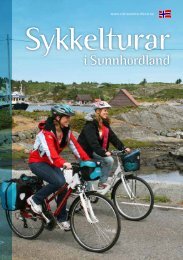
Browse the brochure - Visit Sunnhordland
Browse the brochure - Visit Sunnhordland
Browse the brochure - Visit Sunnhordland

Create successful ePaper yourself
Turn your PDF publications into a flip-book with our unique Google optimized e-Paper software.
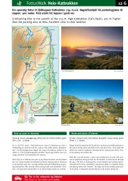
12 Trip suggestions - Fitjar<br />
A view over <strong>the</strong> Fitjar islands<br />
Svartavatnet lake (12,3 km)<br />
A varied route with a steep ascent. On this trip, it’s up<br />
to you whe<strong>the</strong>r you walk or cycle up <strong>the</strong> mountain.<br />
Fitjar<br />
Rimbareid<br />
Storavatnet<br />
Svartavatnet<br />
The route starts in <strong>the</strong> centre of Fitjar, where you will find ‘Cyclist Welcome’<br />
accommodation and bike hire, among o<strong>the</strong>r things. Follow <strong>the</strong> RV 545 road south<br />
past Fitjar church before you turn left onto a narrow country road after one km.<br />
You follow this road up to a car park with a barrier.<br />
This is where <strong>the</strong> gravel path up to Svartavatnet lake starts. There is a steep ascent<br />
initially, but <strong>the</strong> path gradually flattens out.<br />
After cycling 1.7 km from <strong>the</strong> car park, you come to <strong>the</strong> first lake , Olskjødno. The<br />
next lake is situated 0.8 km fur<strong>the</strong>r ahead and is called Kidnavatnet. Midtvatnet<br />
lake <strong>the</strong>n comes into sight and after almost one km, you arrive at Svartavatnet<br />
lake, which is one of Fitjar’s sources of drinking water. Tables and benches have<br />
been set up along <strong>the</strong> gravel path.<br />
200m<br />
0m<br />
0m 3km 6km 9km 12km<br />
Difficulty level: Demanding<br />
Length: 12,3 km<br />
Surface: Tarmac and gravel path<br />
Max. altitude: 387 m<br />
The road to Svartavatnet lake