1JZGauQ
1JZGauQ 1JZGauQ
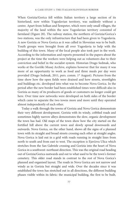
4: CASE STUDY 1: THE ITALIAN/SLOVENIAN BORDER When Gorizia/Gorica fell within Italian territory a large section of its hinterland, now within Yugoslavian territory, was suddenly without a centre. Apart from Solkan and Šempeter, which were only small villages, the majority of the land within the now Yugoslavian territory consisted of farmland (Figure 20). The railway station, the northern of Gorizia/Gorica’s two stations, was the only infrastructure that had been given to Yugoslavia. A new Gorizia or Nova Gorica as it was called in Slovenian was to be built. Youth groups were brought from all over Yugoslavia to help with the building of this town. Many of the local people also took part in the work. According to the information and reports presented in the papers about the project at the time the workers were helping out as volunteers due to their conviction and belief in the socialist system. Historian Drago Sedmak, who works at the Goriški Musej Archive, explains however that for many it was more of an opportunity to work as food and three meals per day were provided (Drago Sedmak, 2011, pers. comm. 1 st August). Pictures from the time show how the open fields were drained and how streets, streetlights and buildings etc. developed into what was to become Nova Gorica. In the period after the new border had been established times were difficult also in Gorizia as many of its producers of goods or customers no longer could get here. Over time new networks were developed on both sides of the border which came to separate the two towns more and more until they operated almost independently of each other. Today a walk through the towns of Gorizia and Nova Gorica demonstrate their very different development. Gorizia with its windy, cobbled roads and sometimes highly narrow alleys demonstrates the slow, organic development the town has had. Old maps of the town show how the city started on the fortified hill above the current town and slowly spread downwards and outwards. Nova Gorica, on the other hand, shows all the signs of a planned town with its straight and broad streets crossing each other at straight angles. Nova Gorica is laid out in a grid with roads running in straight lines from north to south and from east to west. The exception is Ejavčeva Ulica which stretches from the San Gabriele crossing and Gorizia into the heart of Nova Gorica in a southwest–northeast direction. This was the original road heading out of Gorizia/Gorica eastwards and out to what used to be the town’s former cemetery. This older road stands in contrast to the rest of Nova Gorica’s planned and organised layout. The roads in Nova Gorica are not narrow and windy as in Gorizia but straight and wide. Over the decades since it was established the town has stretched out in all directions, the different building phases visible within its fabric: the municipal building, the first to be built, 77
AN ARCHAEOLOGY OF THE IRON CURTAIN together with its immediately surroundings by the road Kidričeva Ulica; the first high rise blocks built in the 1960s to the south of the original cluster; and the recent suburbs expanding along the edges of the city all represent parts of the towns short history. I do not get lost in Nova Gorica but in Gorizia I lose my way all the time, taking a shortcut that leads somewhere completely different. The different stories of these two towns are apparent in their composition and their differences are the consequence of the border imposed on the area in 1947. Figure 20: Picture of the area soon to become Nova Gorica photographed in 1947. The crossing in the picture is today the corner between the streets of Erjavčeva ulica and Škabrijelova ulica. Property of Goriški Muzej, Nova Gorica, Slovenia A border in constant change “A soldier is a soldier, fear is fear and life is life” (Velušček and Medved 2002) Between 1946 and 1948 security was at its highest with Yugoslavian authorities establishing a 5 km security zone along the border. The border was patrolled and soldiers had orders to shoot at anyone trying to cross. Mines and signals were placed by the border in the evenings and were removed in the mornings. Often both the people trying to cross illegally and the guards patrolling the border were armed which created a major insecurity on both parties and a risk of being shot or shooting someone yourself. Often just the insecurity itself led to shootings. It was not unusual for gunfire to be heard 78
- Page 28 and 29: 1: INTRODUCTION itioned somewhere i
- Page 30 and 31: 1: INTRODUCTION World War II dividi
- Page 32 and 33: CHAPTER 2 A physical metaphor Concr
- Page 34 and 35: 2: A PHYSICAL METAPHOR established
- Page 36 and 37: 2: A PHYSICAL METAPHOR The changing
- Page 38 and 39: 2: A PHYSICAL METAPHOR the events t
- Page 40 and 41: 2: A PHYSICAL METAPHOR As time has
- Page 42 and 43: 2: A PHYSICAL METAPHOR highly influ
- Page 44: 2: A PHYSICAL METAPHOR popular idea
- Page 47 and 48: AN ARCHAEOLOGY OF THE IRON CURTAIN
- Page 49 and 50: AN ARCHAEOLOGY OF THE IRON CURTAIN
- Page 51 and 52: AN ARCHAEOLOGY OF THE IRON CURTAIN
- Page 53 and 54: AN ARCHAEOLOGY OF THE IRON CURTAIN
- Page 55 and 56: AN ARCHAEOLOGY OF THE IRON CURTAIN
- Page 57 and 58: AN ARCHAEOLOGY OF THE IRON CURTAIN
- Page 59 and 60: AN ARCHAEOLOGY OF THE IRON CURTAIN
- Page 61 and 62: AN ARCHAEOLOGY OF THE IRON CURTAIN
- Page 63 and 64: AN ARCHAEOLOGY OF THE IRON CURTAIN
- Page 65 and 66: AN ARCHAEOLOGY OF THE IRON CURTAIN
- Page 67 and 68: AN ARCHAEOLOGY OF THE IRON CURTAIN
- Page 69 and 70: AN ARCHAEOLOGY OF THE IRON CURTAIN
- Page 71 and 72: AN ARCHAEOLOGY OF THE IRON CURTAIN
- Page 73 and 74: Figure 16: Postcard of the newly op
- Page 75 and 76: AN ARCHAEOLOGY OF THE IRON CURTAIN
- Page 77: AN ARCHAEOLOGY OF THE IRON CURTAIN
- Page 81 and 82: AN ARCHAEOLOGY OF THE IRON CURTAIN
- Page 83 and 84: AN ARCHAEOLOGY OF THE IRON CURTAIN
- Page 85 and 86: 402 Kojsko Hum 402 THE OSIM
- Page 87 and 88: AN ARCHAEOLOGY OF THE IRON CURTAIN
- Page 89 and 90: AN ARCHAEOLOGY OF THE IRON CURTAIN
- Page 91 and 92: AN ARCHAEOLOGY OF THE IRON CURTAIN
- Page 93 and 94: AN ARCHAEOLOGY OF THE IRON CURTAIN
- Page 95 and 96: AN ARCHAEOLOGY OF THE IRON CURTAIN
- Page 97 and 98: AN ARCHAEOLOGY OF THE IRON CURTAIN
- Page 99 and 100: AN ARCHAEOLOGY OF THE IRON CURTAIN
- Page 101 and 102: AN ARCHAEOLOGY OF THE IRON CURTAIN
- Page 103 and 104: AN ARCHAEOLOGY OF THE IRON CURTAIN
- Page 105 and 106: AN ARCHAEOLOGY OF THE IRON CURTAIN
- Page 107 and 108: AN ARCHAEOLOGY OF THE IRON CURTAIN
- Page 109 and 110: Figure 50: Map demonstrating the bo
- Page 111 and 112: AN ARCHAEOLOGY OF THE IRON CURTAIN
- Page 113 and 114: AN ARCHAEOLOGY OF THE IRON CURTAIN
- Page 115 and 116: AN ARCHAEOLOGY OF THE IRON CURTAIN
- Page 117 and 118: AN ARCHAEOLOGY OF THE IRON CURTAIN
- Page 119 and 120: AN ARCHAEOLOGY OF THE IRON CURTAIN
- Page 121 and 122: AN ARCHAEOLOGY OF THE IRON CURTAIN
- Page 123 and 124: AN ARCHAEOLOGY OF THE IRON CURTAIN
- Page 125 and 126: AN ARCHAEOLOGY OF THE IRON CURTAIN
4: CASE STUDY 1: THE ITALIAN/SLOVENIAN BORDER<br />
When Gorizia/Gorica fell within Italian territory a large section of its<br />
hinterland, now within Yugoslavian territory, was suddenly without a<br />
centre. Apart from Solkan and Šempeter, which were only small villages, the<br />
majority of the land within the now Yugoslavian territory consisted of<br />
farmland (Figure 20). The railway station, the northern of Gorizia/Gorica’s<br />
two stations, was the only infrastructure that had been given to Yugoslavia.<br />
A new Gorizia or Nova Gorica as it was called in Slovenian was to be built.<br />
Youth groups were brought from all over Yugoslavia to help with the<br />
building of this town. Many of the local people also took part in the work.<br />
According to the information and reports presented in the papers about the<br />
project at the time the workers were helping out as volunteers due to their<br />
conviction and belief in the socialist system. Historian Drago Sedmak, who<br />
works at the Goriški Musej Archive, explains however that for many it was<br />
more of an opportunity to work as food and three meals per day were<br />
provided (Drago Sedmak, 2011, pers. comm. 1 st August). Pictures from the<br />
time show how the open fields were drained and how streets, streetlights<br />
and buildings etc. developed into what was to become Nova Gorica. In the<br />
period after the new border had been established times were difficult also in<br />
Gorizia as many of its producers of goods or customers no longer could get<br />
here. Over time new networks were developed on both sides of the border<br />
which came to separate the two towns more and more until they operated<br />
almost independently of each other.<br />
Today a walk through the towns of Gorizia and Nova Gorica demonstrate<br />
their very different development. Gorizia with its windy, cobbled roads and<br />
sometimes highly narrow alleys demonstrates the slow, organic development<br />
the town has had. Old maps of the town show how the city started on the<br />
fortified hill above the current town and slowly spread downwards and<br />
outwards. Nova Gorica, on the other hand, shows all the signs of a planned<br />
town with its straight and broad streets crossing each other at straight angles.<br />
Nova Gorica is laid out in a grid with roads running in straight lines from<br />
north to south and from east to west. The exception is Ejavčeva Ulica which<br />
stretches from the San Gabriele crossing and Gorizia into the heart of Nova<br />
Gorica in a southwest–northeast direction. This was the original road heading<br />
out of Gorizia/Gorica eastwards and out to what used to be the town’s former<br />
cemetery. This older road stands in contrast to the rest of Nova Gorica’s<br />
planned and organised layout. The roads in Nova Gorica are not narrow and<br />
windy as in Gorizia but straight and wide. Over the decades since it was<br />
established the town has stretched out in all directions, the different building<br />
phases visible within its fabric: the municipal building, the first to be built,<br />
77


