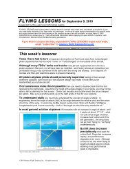
120621 FLYING LESSONS.pdf - FAASafety.gov
120621 FLYING LESSONS.pdf - FAASafety.gov
120621 FLYING LESSONS.pdf - FAASafety.gov

You also want an ePaper? Increase the reach of your titles
YUMPU automatically turns print PDFs into web optimized ePapers that Google loves.
<strong>FLYING</strong> <strong>LESSONS</strong> for June 21, 2012<br />
suggested by this week’s aircraft mishap reports<br />
<strong>FLYING</strong> <strong>LESSONS</strong> uses the past week’s mishap reports to consider what might have contributed to accidents, so you can make better decisions if you face<br />
similar circumstances. In almost all cases design characteristics of a specific make and model airplane have little direct bearing on the possible causes of aircraft<br />
accidents, so apply these <strong>FLYING</strong> <strong>LESSONS</strong> to any airplane you fly. Verify all technical information before applying it to your aircraft or operation, with<br />
manufacturers’ data and recommendations taking precedence. You are pilot in command, and are ultimately responsible for the decisions you make.<br />
If you wish to receive the free, expanded <strong>FLYING</strong> <strong>LESSONS</strong> report each week, email “subscribe” to mastery.flight.training@cox.net.<br />
<strong>FLYING</strong> <strong>LESSONS</strong> is an independent product of MASTERY FLIGHT TRAINING, INC. www.mastery-flight-training.com<br />
This week’s lessons:<br />
The pilot of a turbocharged airplane was cruising westbound at 20,000 feet toward a<br />
line of severe thunderstorms. At 1625 local time, the Center controller advised the pilot of<br />
extreme precipitation at the airplane's 12 o'clock position and 85 miles away, extending north and<br />
south. The pilot acknowledged the information and added that he was looking at it (presumably<br />
on a datalink weather display), and evaluating whether there was any way to get through the line.<br />
At 1626, the controller advised the pilot that there was a break in the extreme<br />
precipitation, but still moderate to heavy precipitation on a heading of 330 degrees at 115 miles.<br />
The pilot stated that he saw that on datalink as well, and thought it would be the best location to<br />
fly through the line of precipitation.<br />
The pilot subsequently received permission to deviate to that location. At 1633, the<br />
controller asked the pilot if he had weather radar onboard, and the pilot replied that he had<br />
"NEXRAD Composite." At 1636, the pilot requested a lower altitude to remain below the freezing<br />
level, and he ultimately descended to 12,000 feet. At 1653, the pilot advised the controller that a<br />
cell had "filled in," but there was still a gap about 10 miles north, which he planned to fly through.<br />
The controller acknowledged the pilot's intentions. No further communication was received from<br />
the accident airplane and radar contact was lost at 1656:27…29 minutes after the first ATC<br />
warning about the radar returns. The airplane broke up in flight after control was lost.<br />
I was attempting a flight from Wichita, Kansas<br />
to Tullahoma, Tennessee (KTHA) that same<br />
afternoon. At almost exactly the same time as the<br />
fatal mishap I diverted to Walnut Ridge, Arkansas<br />
(KARG) because I was approaching a nearly solid<br />
line of heavy precipitation and thunderstorms<br />
extending from the Great Lakes down the<br />
Mississippi River valley to the Gulf of Mexico. The<br />
line was extremely slow-moving, and my<br />
passenger and I ended up staying the night at<br />
Walnut Ridge. We nearly caught up with the<br />
storms at Tullahoma the next morning.<br />
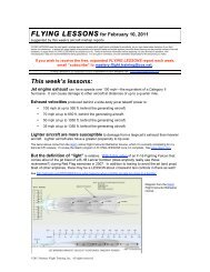
(left) Flightaware.com plot of my flight at the time of the other<br />
aircraft’s in-flight breakup. After we diverted the FlightAware plot<br />
went into coast mode. We did not continue through the lines of heavy<br />
precipitation and storms—which displayed as much worse on my incockpit<br />
weather, and afterward on my iPad display.<br />
The accident pilot saw "moderate to heavy<br />
precipitation" as his best option to get through the<br />
line of storms. But it was better only by<br />
comparison to the better weather around it. Would<br />
the pilot have attempted to fly through such<br />
©2012 Mastery Flight Training, Inc. All rights reserved.
weather otherwise, or would he give pause and divert In other words, did the pilot judge the<br />
weather on its own merits, or did he feel like he had to charge through the line, and chose the<br />
least-impenetrable part instead of an area that would provide safe passage<br />
How current was the imagery in the uplink on which he ultimately bet his life, unsuccessfully<br />
Radar data uplink is updated and transmitted every five minutes by XM providers (by far the most<br />
common provider of weather uplinks). The data itself, however, is up to six minutes old if the<br />
linked surface NEXRAD is in precipitation mode, and as much as 10 minutes out of date if the<br />
linked radar is in “clear air mode.” A date stamp on the in-cockpit display identifies when the<br />
displayed information was sent, but this is only after the delay from linked radar systems.<br />
According to the NTSB, the total delay from radar observation to update in the cockpit may be as<br />
much as 20 minutes—the entire life cycle of an air mass thunderstorm in some cases, and the<br />
time from storm cell formation to reaching the mature stage in most. Since thunderstorms can<br />
build, move and dissipate rapidly, what you see on the screen may not precisely describe the<br />
very real threat out your window.<br />
See www.faa.<strong>gov</strong>/documentLibrary/media/Advisory_Circular/AC%2000-6A%20Chap%2010-12.<strong>pdf</strong><br />
Just yesterday (June 20 th ), the U.S. National Transportation Safety Board (NTSB) released a<br />
Safety Advisory on in-cockpit NEXRAD weather displays, noting the critical need to consider the<br />
“date stamp” when using weather uplinks to make safety decisions in flight. As noted in the<br />
Advisory, “the in-cockpit NEXRAD display depicts where the weather WAS, not where it IS. Read<br />
the Safety Advisory before using in-cockpit NEXRAD displays to make safety-of-flight decisions.<br />
See www.ntsb.<strong>gov</strong>/doclib/safetyalerts/SA_017.<strong>pdf</strong><br />
This is why most weather experts call even weather uplink information “strategic” information<br />
(i.e., used to avoid areas of adverse weather) instead of “tactical” data (used for picking your way<br />
between cells).<br />
Yet pilots seem to be taking more risks with weather uplinks that they do without—reinforced<br />
by recent, independent NTSB and AOPA studies indicating an increased en route weather<br />
accident rate in glass-cockpit airplanes, which typically have weather datalinks. Dr. William<br />
Knecht, senior weather researcher with the Federal Aviation Administration, tells us: “Most of the<br />
time the pilot gets through and is rewarded” for taking the risk. “It’s just every once and a while<br />
that he gets killed.” John King of King Schools warns us that pilot psychology routinely prevents<br />
us from realizing any safety benefit from the addition of enhancements to our aircraft. Instead,<br />
John observes, pilots tend to use additional capabilities to try to increase airplane utility—and in<br />
doing so, inadvertently expose themselves (and their passengers) to increased risk.<br />
A LESSON I learned over many years of studying accident reports and causality is to expect<br />
the need to change plans, and give myself time accordingly. I didn’t need to be in Tullahoma until<br />
noon the next day. Instead of pushing it on Friday morning, I chose to start on Thursday. I even<br />
told my passenger before we left Wichita that we’d probably have to land in Walnut Ridge and reevaluate<br />
the weather with increased resources available on the ground. That’s what we did—<br />
leaving ourselves time to rent a car and drive the rest of the way if needed and still be on site in<br />
time.<br />
There’s no such thing as an all-weather aircraft. If you routinely fly cross-country<br />
you will routinely need to make decisions about diversions and delays. To make better go/no-go<br />
decisions, use advanced avionics and airplane capability to help you avoid the hazards…not try<br />
to fly through them.<br />
See www.kingschools.com<br />
Questions Comments Let us know, at mastery.flight.training@cox.net<br />
©2012 Mastery Flight Training, Inc. All rights reserved.
Thanks to AVEMCO Insurance for helping bring you <strong>FLYING</strong><br />
<strong>LESSONS</strong> Weekly.<br />
See www.avemco.com/default.aspxpartner=WMFT.<br />
Contact mastery.flight.training@cox.net for sponsorship information.<br />
Every little bit helps cover the expenses of keeping <strong>FLYING</strong> <strong>LESSONS</strong> online. Please support <strong>FLYING</strong> <strong>LESSONS</strong> with your secure PayPal donation<br />
at www.mastery-flight-training.com. Thank you, generous supporters!<br />
"Some people do something wrong for years and call it experience."<br />
-- Norm Komich, on Robert M. Jenny’s Cockpit Concepts at www.aviation.org.<br />
“We try to teach pilots how to identify risk and how to quantify it, but not what to do about it.”<br />
-- Aviation safety consultant Robert Wright, at the NTSB General Aviation Safety Forum: Climbing to the<br />
Next Level,” June 19, 2012<br />
“The technology is outpacing the [pilot’s] understanding” of in-cockpit weather.<br />
-- Bob Dreisewerd, Baron Services (which provides the weather data used by XM datalink and other<br />
services), at the NTSB General Aviation Safety Forum: Climbing to the Next Level,” June 20, 2012<br />
“If a pilot sees a hole [on in-cockpit radar depictions] he tends to go through. Higher resolution is<br />
not always a good thing.”<br />
-- Dr. William Knecht, FAA weather human factors researcher,<br />
at the NTSB General Aviation Safety Forum: Climbing to the Next Level,” June 20, 2012<br />
“[General aviation] pilots are the chief pilot of an airline of one.”<br />
-- Deborah A.P. Hersman, Chairman, National Transportation Safety Board,<br />
in her opening comments to the NTSB General Aviation Safety Forum: Climbing to the Next Level,”<br />
June 19, 2012<br />
See www.ntsb.<strong>gov</strong>/news/events/2012/GA_safety/index.html<br />
Share safer skies. Forward <strong>FLYING</strong> <strong>LESSONS</strong> to a friend.<br />
Personal Aviation: Freedom. Choices. Responsibility.<br />
Thomas P. Turner, M.S. Aviation Safety, MCFI<br />
2010 National FAA Safety Team Representative of the Year<br />
2008 FAA Central Region CFI of the Year<br />
<strong>FLYING</strong> <strong>LESSONS</strong> is ©2012 Mastery Flight Training, Inc. Copyright holder provides permission for <strong>FLYING</strong><br />
<strong>LESSONS</strong> to be posted on <strong>FAASafety</strong>.<strong>gov</strong>. For more information see www.mastery-flight-training.com, or<br />
contact mastery.flight.training@cox.net or your FAASTeam representative.<br />
©2012 Mastery Flight Training, Inc. All rights reserved.