GlassHouse Mountains Driving Map - Hinterland Tourism:Sunshine ...
GlassHouse Mountains Driving Map - Hinterland Tourism:Sunshine ...
GlassHouse Mountains Driving Map - Hinterland Tourism:Sunshine ...

Create successful ePaper yourself
Turn your PDF publications into a flip-book with our unique Google optimized e-Paper software.
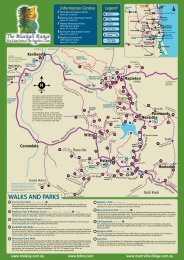
Bald Knob Road<br />
To Kilcoy<br />
& Woodford<br />
LEGEND<br />
Toilets<br />
Lookout<br />
Picnic Area<br />
Golf Course<br />
Bowls Club<br />
Police Station<br />
Café<br />
Accommodation<br />
Caravan Park<br />
Strawberry Farm<br />
Sealed Road<br />
Gravel Road<br />
Info Centre<br />
Peachester<br />
FOR YOUR SAFETY!<br />
Wear sturdy, enclosed<br />
shoes. Surfaces can<br />
be slippery. Carry drinking water.<br />
Plan to complete your walk<br />
well before dark. Wear a hat,<br />
sunscreen and insect repellent.<br />
Stay on marked tracks.<br />
Use a map or track guide. Obey<br />
all safety and warning signs.<br />
Mobile phone reception may be<br />
unreliable in areas. In case of<br />
emergency call 000 or 112 if you<br />
are experiencing bad reception.<br />
To Woodford<br />
Glass House <strong>Mountains</strong><br />
National Park<br />
Mt Beerwah<br />
556m<br />
24<br />
Mt Coonowrin<br />
Mt Beerwah Road<br />
20 13<br />
Old Gympie Road<br />
Glass House - Woodford Road (sealed to lookout)<br />
Glass House <strong>Mountains</strong><br />
Lookout<br />
Mt Tunbubudla<br />
or The Twins<br />
Maleny Visitor<br />
Info Centre<br />
07 5499 9033<br />
Bald Knob Road<br />
6<br />
Glass<br />
House<br />
Country<br />
377m<br />
Old Gympie Road<br />
To Maleny, Montville, the walks<br />
and villages of The Blackall Range<br />
(separate map available)<br />
Peachester Road<br />
Glass House <strong>Mountains</strong><br />
National Park<br />
Beerburrum - Woodford Road<br />
338m and 296 m<br />
20<br />
Lindeman Road<br />
Mooloolah<br />
Landsborough - Maleny Road<br />
Old Gympie Road<br />
Mt Coochin<br />
Pikes Road<br />
Sahara Road<br />
Fullertons Road<br />
Bankfoot House<br />
Marshs Road<br />
Mt Mellum<br />
235m<br />
Mt Ngungun<br />
Coonowrin Road<br />
Landsborough<br />
TRAIN STATION<br />
Aboriginal site<br />
Scout camp<br />
Glass House <strong>Mountains</strong><br />
National Park<br />
253m<br />
23<br />
Pine Camp Road<br />
Dularcha<br />
National<br />
Park<br />
Beerwah<br />
Barrs Road<br />
Youngs Road<br />
Mt Cooee<br />
Mt Tibrogargan<br />
364m<br />
Mt Tibberoowuccum<br />
220m<br />
Glass House <strong>Mountains</strong><br />
National Park<br />
Brandenburg Road<br />
TRAIN STATION<br />
TRAIN STATION<br />
Mt Beerburrum<br />
280m<br />
Old Landsborough Road<br />
10<br />
To Palmwoods<br />
Landsborough<br />
Historical Museum<br />
Moroney Place<br />
14 15<br />
19<br />
16<br />
21<br />
22<br />
9<br />
Roys Road<br />
18<br />
8<br />
Kings Road<br />
Simpson Steet<br />
Glass House <strong>Mountains</strong><br />
TRAIN STATION<br />
Bowen Road<br />
Tunnel Ridge Road<br />
Beerburrum<br />
TRAIN STATION<br />
7<br />
6<br />
Beerwah Detail<br />
11<br />
12<br />
13<br />
Burys Road<br />
Brenda Crt<br />
Mooloolah Connection Road<br />
Ewen Maddock Dam<br />
Steve Irwin Way<br />
Roys Road<br />
17<br />
Glass House <strong>Mountains</strong> Info Centre<br />
07 5438 7220<br />
Johnston Road<br />
Bruce Highway<br />
4<br />
5<br />
RSL Club<br />
Hotel<br />
To Golf<br />
Club<br />
Mooloolah River<br />
National Park Jowarra Section<br />
Wild Horse Mountain<br />
123m<br />
Steve Irwin Way<br />
Bruce Highway<br />
Roys Road<br />
To Noosa<br />
& Eumundi<br />
To Coochin Creek<br />
Camping Area<br />
To Caloundra<br />
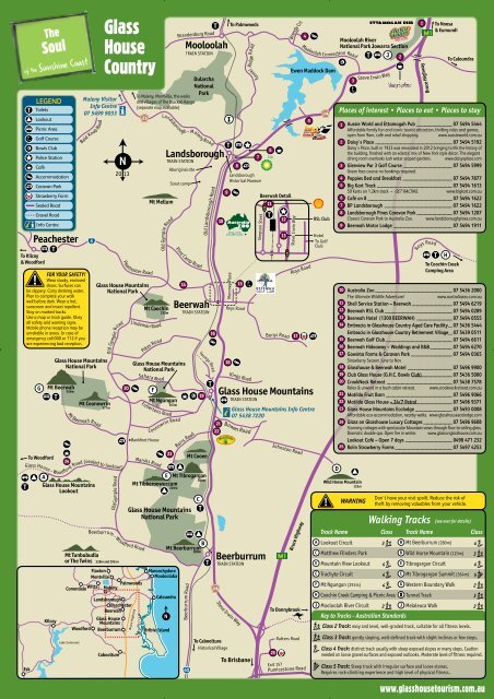
Places of interest • Places to eat • Places to stay<br />
1<br />
2<br />
3<br />
4<br />
5<br />
6<br />
7<br />
8<br />
9<br />
10<br />
11<br />
12<br />
13<br />
14<br />
15<br />
16<br />
17<br />
18<br />
19<br />
20<br />
21<br />
22<br />
23<br />
24<br />
25<br />
3<br />
2<br />
Aussie World and Ettamogah Pub 07 5494 5444<br />
Affordable family fun and iconic tourist attraction, thrilling rides and games,<br />
open from 9am, café and retail shopping.<br />
www.aussieworld.com.au<br />
Daisy's Place 07 5494 5192<br />
Daisy's Place, built in 1923 was renovated in 2012 bringing to life the history of<br />
the building, finished with an eclectic mix of New York style décor. The elegant<br />
dining room overlooks lush water scaped gardens. www.daisysplace.com<br />
Glenview Par 3 Golf Course 07 5494 5999<br />
Green fees course no bookings required.<br />
Poppies Bed and Breakfast 07 5494 7877<br />
Big Kart Track 07 5494 1613<br />
50 Karts on 1.2km track – GET RACING. www.bigkart.com.au<br />
Café on 8 07 5494 1622<br />
BP Landsborough 07 5494 1622<br />
Landsborough Pines Caravan Park 07 5494 1207<br />
Closest Caravan Park to Australia Zoo. www.landsboroughpines.com.au<br />
Beerwah Motor Lodge 07 5494 1911<br />
Australia Zoo 07 5436 2000<br />
The Ultimate Wildlife Adventure!<br />
www.australiazoo.com.au<br />
Shell Service Station – Beerwah 07 5494 6219<br />
Beerwah RSL Club 07 5494 0289<br />
Beerwah Hotel (1300 BEERWAH) 07 5494 0555<br />
Embracia in Glasshouse Country Aged Care Facility 07 5436 5444<br />
Embracia in Glasshouse Country Retirement Village 07 5439 0511<br />
Beerwah Golf Club 07 5494 6611<br />
Beerwah Hideaway – Weddings and B&B 07 5494 6270<br />
Gowinta Farms & Caravan Park 07 5494 0365<br />
Strawberry Season June to Nov<br />
Glasshouse & Beerwah Motel 07 5496 9900<br />
Club Glass House (G.H.C. Bowls Club) 07 5436 5000<br />
CrookNeck Retreat 07 5438 7578<br />
Relax & unwind in a bush cabin retreat. www.crookneckretreat.com.au<br />
Matilda Fruit Barn 07 5496 9066<br />
Matilda Glass House – 24/7 Petrol 07 5496 9371<br />
Glass House <strong>Mountains</strong> Ecolodge 07 5493 0008<br />
Affordable eco-accommodation, nearby walks. www.glasshouseecolodge.com<br />
Glass on Glasshouse Luxury Cottages 07 5496 9608<br />
Stunning cottages with spectacular Mountain views through floor-to-ceiling glass.<br />
Dramatic double spa. Open fire in winter. www.glassonglasshouse.com.au<br />
Lookout Café – Open 7 days 0498 471 232<br />
Rolin Strawberry Farms 07 5497 4253<br />
WARNING<br />
1<br />
Don't have your visit spoilt. Reduce the risk of<br />
theft by removing valuables from your vehicle.<br />
Walking Tracks (see over for details)<br />
Track Name Class Track Name Class<br />
Lookout Circuit 3 Mt Beerburrum (280m) 4<br />
Matthew Flinders Park Wild Horse Mountain (123m) 3<br />
Mountain View Lookout 4 Tibrogargan Circuit 4<br />
Trachyte Circuit 4 Mt Tibrogargan Summit (364m) 5<br />
Palmwoods<br />
Peachester<br />
Bruce Highway<br />
Beerburrum Road<br />
Steve Irwin Way<br />
To Donnybrook<br />
Mt Ngungun (253m) 4 Western Boundary Walk 2<br />
Coochin Creek Camping & Picnic Area Tunnel Track 3<br />
Mooloolah River Circuit 2 Melaleuca Walk 2<br />
Key to Tracks - Australian Standards<br />
Class 2 Track: easy and level, well-graded track, suitable for all fitness levels.<br />
Lake Somerset<br />
60<br />
To Caboolture<br />
Historical Village<br />
To Brisbane<br />
Rutters Road<br />
25<br />
Exit 157<br />
Pumicestone Road<br />
Class 3 Track: gently sloping, well-defined track with slight inclines or few steps.<br />
Class 4 Track: distinct track usually with steep exposed slopes or many steps. Caution<br />
needed on loose gravel surfaces and exposed outlooks. Moderate level of fitness required.<br />
Class 5 Track: Steep track with irregular surface and loose stones.<br />
Requires rock-climbing experience and high level of physical fitness.<br />
www.glasshousetourism.com.au
The Geology & European History<br />
The Glass House <strong>Mountains</strong> are subterranean intrusions of<br />
magna formed throughout the area some 25 million years ago.<br />
Overtime the softer rock surrounding these intrusions has been<br />
eroded away. This has left the hard solidified molten rock spires<br />
(rhyolyte and trachyte) that are the Glass House <strong>Mountains</strong> we see<br />
today. If you stand at the Glass House <strong>Mountains</strong> Information Centre<br />
25 million years ago you would be some 300 metres underground!<br />
There are a total of fourteen mountains in the area, the highest being<br />
Mt. Beerwah at 556 metres. Lieutenant James Cook first sighted the<br />
Glass House <strong>Mountains</strong> on Thursday 17 th May 1770.<br />
He named them "The Glass Houses" after the shape of the glass<br />
kilns back in the north of England with which he was familiar.<br />
He named Moreton Bay after Lord Moreton who was President of<br />
the Royal Society at that time. Twenty nine years later on the 26 th July<br />
1799 Lieutenant Matthew Flinders came ashore with a small party of<br />
men and climbed Mt. Beerburrum. They camped that night at what is<br />
known today as Matthew Flinders Park, shown as on the <strong>Map</strong>.<br />
The Legend of the Glass House <strong>Mountains</strong><br />
Back in the mists of time when the world was a very different place,<br />
the storytellers talk of a family that lived by the sea.<br />
The father was named Tibrogargan and the mother Beerwah.<br />
They lived happily and had many children. The eldest was Coonowrin<br />
followed by Coochin, Beerburrum, the Tunbubudla twins, Ngungun,<br />
Tibberoowuccum, Miketeebumulgrai and Elimbah.<br />
Tibrogargan was once down at the shore when he noticed with alarm<br />
that the sea was dramatically rising. Running to find his family, he<br />
shouted to Coonowrin to help his mother, who was pregnant at the<br />
time, and gather up the young children. Coonowrin was instructed<br />
to lead her to the safety of higher ground. Tibrogargan looked back<br />
to see how Coonowrin was managing, only to see him running away<br />
on his own intent on saving his own life.<br />
Tibrogargan was really angry at this display of cowardice and went<br />
after Coonowrin. When he finally caught up with him, he struck him<br />
a mighty blow. His neck was dislocated and Coonowrin (Crookneck)<br />
has not been able to straighten it ever since.<br />
When you look at the mountains today you will see that Tibrogargan<br />
still sits with his back to his son and gazes out to sea.<br />
Coonowrin has still not been forgiven by the family and hangs his<br />
head in shame. Late on a cold brittle winter's night you may hear<br />
him softly crying as his tears roll down to form the many streams<br />
which flow down to the sea from where his troubles began.<br />
WARNING – Don't have your visit spoilt. Reduce the<br />
risk of theft by removing valuables from your vehicle.<br />
Glass House <strong>Mountains</strong> Lookout<br />
A 9km drive from Glass House <strong>Mountains</strong> township will take you<br />
to the main lookout for the area. The sheltered fire tower provides a<br />
platform to view the mountain peaks — Caloundra, Maroochydore,<br />
Brisbane and Moreton Island. You can drive to the lookout where there<br />
are BBQ facilities, picnic areas and interpretive signage.<br />
Lookout Circuit 800m circuit. Allow 25min. Class 3<br />
A short walking track takes you through open scribbly gum forest, down<br />
through a wet sclerophyll forest gully and back to the lookout. This track<br />
is quite steep in places.<br />
Mount Beerburrum (280m)<br />
Mount Beerburrum Track Class 4<br />
1.4km return. Allow 1hr.<br />
The steep paved track leads you to a fire tower which offers great views<br />
to the surrounding area. Mount Beerburrum's fire tower is used to<br />
detect and manage fires throughout the forestry areas.<br />
Wild Horse Mountain (123m)<br />
Wild Horse Mountain Lookout Track Class 3<br />
1.4km return. Allow 1hr.<br />
Turn off the Bruce Highway at the Mobil Service Station or take the<br />
Bowen Road turnoff 1km south of the Glass House <strong>Mountains</strong> township.<br />
Wild Horse Mountain is named after the brumbies (wild horses) that<br />
once lived there. A moderately steep paved track leads to the lookout.<br />
Enjoy panoramic 360 degree views of Pumicestone Passage, coastal<br />
plains, the Glass House <strong>Mountains</strong> and forestry plantations from the<br />
sheltered fire tower platform.<br />
Mount Tibrogargan (364m)<br />
Mountain View Lookout Class 4<br />
800m return walk from carpark. Allow 45min.<br />
Walk to a lookout with views over Mount Beerwah, Mount Coonowrin,<br />
Mount Tibberoowuccum and Mount Tunbubudla.<br />
1 Tibrogargan Circuit - Track Class 4<br />
3.3km circuit. Allow 1.5hrs.<br />
This walking track leads around the base of Mount Tibrogargan through<br />
casuarina groves, open eucalypt and melaleuca forests. The trail offers<br />
great views of Mount Tibrogargan. Look up occasionally - peregrine<br />
falcons may be circling overhead.<br />
2 Trachyte Circuit - Track Class 4<br />
5.6km return walk from carpark. Allow 2 - 3hrs.<br />
This circuit links Mount Tibrogargan, Mount Tibberoowuccum and the<br />
Trachyte range. It passes exotic pine plantations and native forest<br />
before heading up to the Jack Ferris lookout. The lookout and walking<br />
track was constructed with assistance from local community group Glass<br />
House <strong>Mountains</strong> Advanced Network (GMAN) as part of the Centenary<br />
of Federation celebrations in 2000.<br />
Mount Tibrogargan Summit Class 5<br />
3km return. Allow 3 - 4hrs.<br />
Caution: These trails require some rock climbing experience.<br />
Considerable exposure to the elements may be experienced.<br />
Mt Tibrogargan<br />
Marshs Rd<br />
Mt Tibberoowuccum<br />
2<br />
Trachyte<br />
1<br />
Mt Tibrogargan<br />
Glass House<br />
1<br />
2<br />
<strong>Mountains</strong><br />
National Park<br />
circuit<br />
Tibrogargan Creek<br />
2<br />
Caves Rd<br />
Scale<br />
0 1km<br />
N<br />
Steve Irwin Way<br />
Matthew Flinders<br />
Park<br />
Mount Ngungun (253m)<br />
Mount Ngungun Summit Class 4<br />
2.4km return. Allow 2hrs.<br />
This summit provides spectacular views of all of the four major<br />
mountain peaks. The trail is relatively short but steep in places and may<br />
be unstable in some sections. Family groups should be careful, as the<br />
trail passes close to the cliff line. Adults should supervise children at all<br />
times. Warning: this track can become very slippery when wet.<br />
Mt Ngungun<br />
Glass House<br />
<strong>Mountains</strong><br />
National Park<br />
Fullertons Rd<br />
Scale<br />
0 200m<br />
The Mount Beerwah summit trail, including access to the cliff face<br />
lookout, is closed until further notice due to a major rockfall. On-the-spot<br />
fines are issued for accessing an area closed to the public. The picnic<br />
facilities and toilets remain open.<br />
Western Boundary Walk Class 2<br />
1.4 km return walk from the picnic area to the western park boundary<br />
gate. Allow 45min.<br />
Mt Beerwah<br />
Glass House<br />
<strong>Mountains</strong><br />
National Park<br />
Legend<br />
Walking track<br />
Access road<br />
Mt Beerwah Rd<br />
Walking track<br />
Scale<br />
0 1km<br />
Mt Ngungun<br />
summit<br />
Mt Beerwah<br />
Legend<br />
Walking track<br />
Steep hiking<br />
trail<br />
Abseiling & rock climbing - WARNING<br />
Suitable for experienced climbers only<br />
No artificial anchors at rock climbing sites have been approved for<br />
use by the National Parks, Recreation, Sports and Racing.<br />
Mount Ngungun (253m)<br />
This mountain provides opportunities for moderately challenging<br />
rock-face climbing and abseiling for 20 - 45 metre roped sports.<br />
Equipment and expertise is required.<br />
Mount Tibrogargan (364m)<br />
This mountain provides opportunities for challenging and potentially<br />
dangerous rock-face climbing. A high level of expertise and<br />
specialised equipment, in good condition, is required.<br />
Summit access - WARNING<br />
Suitable for experienced rock climbers only<br />
Routes that lead to the summits have steep rocky sections and<br />
irregular surfaces with loose stones that require rock scrambling and<br />
rock climbing skills.<br />
Never attempt these tracks in wet weather as smooth surfaces can<br />
be slippery and dangerous. Flexible soled shoes with good grip<br />
should be worn.<br />
Mount Beerwah (556m)<br />
Access Road<br />
Beerburrum State Forest<br />
N<br />
N<br />
Tunnel Track Class 3<br />
6km return. Allow 2hrs.<br />
Featuring a heritage listed railway tunnel that is home to many small<br />
nocturnal bats. Park at the Landsborough railway station, catch a train<br />
to Mooloolah and walk back through the national park to your car.<br />
Toilets and picnic areas are located in adjacent towns.<br />
Dularcha<br />
Legend<br />
Walking track<br />
Railway line<br />
Maleny<br />
Coochin Creek camping & day-use area<br />
Ideal for fishing and boating. Take Roys Rd from the Bruce Hwy and<br />
follow the signs. Camping permits must be obtained in advance from<br />
www.qld.gov.au/camping or by calling 13 74 68 (24hrs).<br />
Preferably bring a fuel stove. Use fire rings provided, not an open fire.<br />
Bring your own clean cut, milled firewood. It is illegal to collect firewood<br />
in this area. Domestic animals are not permitted.<br />
Dularcha National Park<br />
Old Maleny Rd<br />
Maleny St<br />
King Rd<br />
Tunnel<br />
Scale<br />
0 2km<br />
Paget St<br />
Beech Rd<br />
Myla Rd<br />
Cribb St<br />
Mooloolah Connection Rd<br />
Mooloolah<br />
Railway<br />
Station<br />
Dularcha<br />
National<br />
Park<br />
Caloundra St<br />
Tunnel Ridge Rd<br />
Landsborough<br />
Railway<br />
Station<br />
Caloundra<br />
N<br />
Caloundra<br />
Mooloolah River National Park Jowarra Sect.<br />
Jowarra<br />
Situated on the banks of the Mooloolah River, this is one of the few<br />
remaining coastal rainforest areas. It is an important home for wildlife<br />
including the wompoo pigeon, eastern yellow robin, and the vulnerable<br />
Richmond birdwing butterfly. Insect repellant may help to deter<br />
mosquitoes and leeches.<br />
1 Mooloolah River Circuit Class 2<br />
500m circuit. Allow 20min.<br />
This short self guided rainforest walk winds along a crystal clear creek.<br />
The fruiting fig trees attract many birds.<br />
2<br />
Melaleuca Walk Class 2<br />
1.3km return. Allow 40min.<br />
Explore rainforest with piccabeen palm groves, eucalypt forest and<br />
melaleuca swamp. The river is home to platypus, which may be seen at<br />
dawn and dusk if you sit patiently and quietly.<br />
Jowarra<br />
Legend<br />
Walking track<br />
Mooloolah River<br />
1<br />
Scale<br />
0 200m<br />
2<br />
N<br />
Mooloolah River NP<br />
Jowarra Section<br />
Steve Irwin Way<br />
Beerwah<br />
State Forest<br />
To Bruce Hwy Nth<br />
Caloundra<br />
Every effort has been made to ensure the accuracy and reliability of the information contained in this<br />
map. <strong>Hinterland</strong> <strong>Tourism</strong> <strong>Sunshine</strong> Coast and the producers of this map accept no responsibility or<br />
liability for the accuracy of the information presented. This map is not to scale.<br />
2<br />
This map is produced by <strong>Hinterland</strong> <strong>Tourism</strong> <strong>Sunshine</strong> Coast, with special<br />
thanks to Ivon Northage. For membership details or further copies of this<br />
map email admin@hinterlandtourism.com<br />
Check out our website!<br />
www.glasshousetourism.com.au