Staying Safe Flood Guide - Guadalupe-Blanco River Authority
Staying Safe Flood Guide - Guadalupe-Blanco River Authority
Staying Safe Flood Guide - Guadalupe-Blanco River Authority

You also want an ePaper? Increase the reach of your titles
YUMPU automatically turns print PDFs into web optimized ePapers that Google loves.
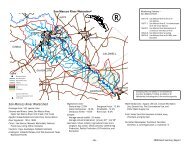
How to Determine <strong>River</strong> Elevation<br />
1. Locate the USGS gauge closest to your home (refer to following map and chart)<br />
2. Calculate your potential to be flooded as follows:<br />
a. Obtain the river stage from NWS bulletins, forecasts, etc.<br />
b. Add that number to the datum for the gauge closest to your location to find the<br />
present river level at MSL.<br />
c. Compare that to the MSL for your home's slab. If there is any possibility your<br />
home may flood, prepare to evacuate.<br />
Example:<br />
You live in New Braunfels and your house slab elevation is 590.0 feet mean sea level<br />
(msl), according to your subdivision plat or floodplain permit. The closest river gauge to<br />
you is the one located on the <strong>Guadalupe</strong> <strong>River</strong> at New Braunfels above the Comal <strong>River</strong>.<br />
The datum for this gauge is 586.65 feet msl. Your NOAA weather radio alerts you to a<br />
forecast peak stage of 10 feet for the gauge closest to you.<br />
<strong>Flood</strong> potential = <strong>River</strong> Stage + Datum<br />
= 10 Ft. + 586.65 Ft.<br />
= 596.65 Ft.<br />
Since your slab is at 590.0 feet, you will potentially have six feet of water in your house.<br />
13