Staying Safe Flood Guide - Guadalupe-Blanco River Authority
Staying Safe Flood Guide - Guadalupe-Blanco River Authority
Staying Safe Flood Guide - Guadalupe-Blanco River Authority

Create successful ePaper yourself
Turn your PDF publications into a flip-book with our unique Google optimized e-Paper software.
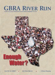
GBRA<br />
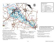
<strong>Flood</strong>water is released from the Canyon Reservoir <strong>Flood</strong> Pool at rates up to 5,000 cubic<br />
feet per second. Releases are carefully scheduled so they will not contribute to existing<br />
downstream flooding.<br />
The upper portion, or <strong>Flood</strong> Pool, extends from elevation 909 to the level of the emergency<br />
spillway at 943 feet msl and is managed by the U.S. Army Corps of Engineers.<br />
This portion of the reservoir is kept empty and may only be used to hold flood runoff<br />
from heavy rainfall events in the upper <strong>Guadalupe</strong> <strong>River</strong> Basin. This area includes Kerr,<br />
Kendall and Comal counties, whose rocky terrain and rapid decline in elevation can quickly<br />
create river rises and flash flooding.<br />
Public Law 566 Structures<br />
Some counties in the <strong>Guadalupe</strong> <strong>River</strong> Basin have small off-channel flood control<br />
structures authorized under Public Law 566. The federal government usually pays for the<br />
construction of these small dams, with counties or local sponsors paying to lease land on<br />
private property and for dam maintenance. These PL-566 structures are designed to capture<br />
some floodwaters from rapid rises along creeks and streams and are credited with<br />
preventing additional damage in Caldwell, Comal, <strong>Guadalupe</strong> and Hays counties during<br />
the October 1998 flood.<br />
Unfortunately, most of the rainfall in October 1998 fell adjacent to and below Canyon<br />
Dam and these small reservoirs. As a result, much of the floodwater flowed unrestricted<br />
into the main channel of the <strong>Guadalupe</strong> <strong>River</strong> above New Braunfels. Because there are no<br />
flood control structures on the river between New Braunfels and the coast, the floodwaters<br />
were able to move downstream unrestrained.<br />
8