Staying Safe Flood Guide - Guadalupe-Blanco River Authority
Staying Safe Flood Guide - Guadalupe-Blanco River Authority
Staying Safe Flood Guide - Guadalupe-Blanco River Authority

You also want an ePaper? Increase the reach of your titles
YUMPU automatically turns print PDFs into web optimized ePapers that Google loves.
Structural Management<br />
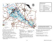
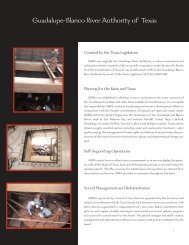
The <strong>Guadalupe</strong>-<strong>Blanco</strong> <strong>River</strong> <strong>Authority</strong> was created by the Texas Legislature in 1935 to<br />
develop, conserve and protect the water resources of the <strong>Guadalupe</strong> <strong>River</strong> Basin. In<br />
the 1950's, plans were finalized to build Canyon Dam and Reservoir on the main stem of<br />
the <strong>Guadalupe</strong> <strong>River</strong> near Sattler. Canyon Dam is the only flood control dam located on<br />
the <strong>Guadalupe</strong> <strong>River</strong>.<br />
Canyon Dam and Reservoir<br />
This dual-purpose reservoir was completed in 1963 through a cooperative effort<br />
between GBRA and the U.S. Army Corps of Engineers, with GBRA serving as local sponsor<br />
for the project. Canyon Reservoir provides flood control benefits and also serves as a<br />
dependable source of stored water.<br />
The dam is an earthfill embankment 224 feet high and 6,830 feet long. The reservoir<br />
behind the dam is best understood by thinking of it as a two-part storage chamber. The<br />
lower portion, or Conservation Pool, extends from elevation 800 to 909 feet mean sea<br />
level (msl) and stores water for cities, industries and agricultural users downstream of<br />
Canyon Dam. GBRA is responsible for the Conservation Pool and, under a TNRCC permit,<br />
is authorized to divert a specific amount of stored water each year to supply contracted<br />
water users.<br />
7