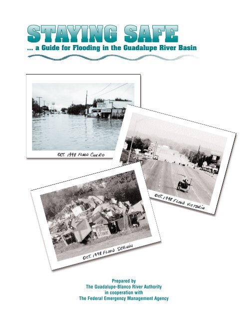
Staying Safe Flood Guide - Guadalupe-Blanco River Authority
Staying Safe Flood Guide - Guadalupe-Blanco River Authority
Staying Safe Flood Guide - Guadalupe-Blanco River Authority

Create successful ePaper yourself
Turn your PDF publications into a flip-book with our unique Google optimized e-Paper software.
... a <strong>Guide</strong> for <strong>Flood</strong>ing in the <strong>Guadalupe</strong> <strong>River</strong> Basin<br />
Prepared by<br />
The <strong>Guadalupe</strong>-<strong>Blanco</strong> <strong>River</strong> <strong>Authority</strong><br />
in cooperation with<br />
The Federal Emergency Management Agency
<strong>Staying</strong> <strong>Safe</strong><br />
...A <strong>Guide</strong> for <strong>Flood</strong>ing in the <strong>Guadalupe</strong> <strong>River</strong> Basin<br />
If you live in the <strong>Guadalupe</strong> <strong>River</strong> Basin, you also live in one of the three most dangerous<br />
regions in the U.S.A. for flash floods! Local residents and weather experts refer to the<br />
Texas Hill Country as ‘Flash <strong>Flood</strong> Alley,’ because heavy rainfall and runoff from creeks and<br />
streams can cause rapid rises and flooding in a matter of hours.<br />
This publication is designed to prepare you for such an event by increasing public<br />
awareness about the dangers of flooding in the <strong>Guadalupe</strong> <strong>River</strong> Basin. The <strong>Guadalupe</strong><br />
<strong>River</strong> experienced major floods in 1936, 1952, 1972, 1973, 1978, 1987, 1991 and 1997.<br />
Last year’s flood of October 1998 developed in a matter of hours, broke most existing<br />
records, exceeded the 100-year flood plain, and inundated areas that had never been<br />
flooded before. It was the flood that many thought would never happen. But floods are<br />
not predictable. They do not follow measured cycles. They destroy homes, businesses<br />
and take lives. Unfortunately, an even greater flood will occur sometime in the future.<br />
The <strong>Guadalupe</strong>-<strong>Blanco</strong> <strong>River</strong> <strong>Authority</strong> and the Federal Emergency Management Agency<br />
are concerned first and foremost about your safety. The more you know, the more you<br />
can take steps now to protect yourself, your family and your property against the hazards<br />
of future flooding.<br />
GBRA
<strong>Staying</strong> <strong>Safe</strong><br />
...A <strong>Guide</strong> for <strong>Flood</strong>ing in the <strong>Guadalupe</strong> <strong>River</strong> Basin<br />
Produced by GBRA departments of Engineering, and<br />
Communications and Education through a grant from the<br />
Federal Emergency Management Agency. Statements and<br />
opinions expressed herein should not be interpreted as<br />
endorsements by FEMA.<br />
Writing and Editing:<br />
Judy Gardner, Tommy Hill, Wayne Tschirhart<br />
Design and Layout:<br />
Connie Rothe<br />
Federal Emergency Management Agency -<br />
Region VI<br />
(940) 898-5399<br />
www.fema.gov<br />
<strong>Guadalupe</strong>-<strong>Blanco</strong> <strong>River</strong> <strong>Authority</strong><br />
933 East Court Street<br />
Seguin, Texas 78155<br />
(830) 379-5822<br />
www.gbra.org
Dear residents of the <strong>Guadalupe</strong> <strong>River</strong> Basin:<br />
The area we have chosen to call home is a place of great scenic beauty and recreational<br />
opportunities. It is no wonder that thousands of people choose to live along its rivers<br />
and lakes, or that many thousands more come here to enjoy its cool, clear waters.<br />
However, the basin has a dual personality. Heavy rainfall and runoff can quickly<br />
change its usually peaceful nature into a raging torrent of floodwaters, capable of<br />
destroying homes, businesses and even lives.<br />
The <strong>Flood</strong> of October 1998 broke previous flood records throughout the <strong>Guadalupe</strong><br />
<strong>River</strong> Basin and reached or exceeded “500-year” flood projections in some areas.<br />
Overnight, all of us faced the humbling awareness that despite man’s efforts to set “worst<br />
case scenario” limits, Mother Nature has none. The next flood, and there will be another,<br />
could be even more severe given the right set of circumstances.<br />
The National <strong>Flood</strong> Insurance Program of the Federal Emergency Management Agency<br />
makes flood insurance available to safeguard you against devastating financial losses<br />
from these events. The program’s floodplain management regulations prevent new development<br />
from increasing the threat of flooding to existing structures and protects new<br />
buildings from future flood losses.<br />
The <strong>Guadalupe</strong>-<strong>Blanco</strong> <strong>River</strong> <strong>Authority</strong> and the Federal Emergency Management<br />
Agency are working together to minimize damage from future flooding in the basin, but<br />
we cannot do it alone. Your cooperation is vital if we are to manage property loss and<br />
damage in the basin and your communities.<br />
This publication contains the most current information we have about how to prepare<br />
for a flood event. Please read it carefully and keep it handy for future reference. Public<br />
awareness and knowledge is our best weapon in the campaign to prevent unnecessary<br />
flood damage and needless loss of life. With your support, our goal of improving the<br />
safety of people and property in the <strong>Guadalupe</strong> <strong>River</strong> Basin can be achieved.<br />
W. E. “Bill” West, Jr.<br />
General Manager<br />
<strong>Guadalupe</strong>-<strong>Blanco</strong> <strong>River</strong> <strong>Authority</strong><br />
Buddy Young<br />
Regional Director, Region VI<br />
Federal Emergency Management Agency<br />
1
Seguin Gazette-Enterprise<br />
Seguin Gazette-Enterprise<br />
GBRA<br />
2
The <strong>Flood</strong> of October 1998 - Disaster in the<br />
<strong>Guadalupe</strong> <strong>River</strong> Basin<br />
On Saturday, October 17, 1998 many people had no idea that within a few short days<br />
their lives would be changed forever. The day began with heavy rains that saturated<br />
the soil over a large part of the river basin. At first, it appeared that rainfall runoff would<br />
develop into a typical central Texas Hill Country flood, with limited coverage.<br />
But Texas weather can be extreme and unpredictable. Depending on weather patterns,<br />
there may be months or years of drought followed by a devastating flood. Arctic cold<br />
fronts sweep into the state as easily as moisture and storms from the Gulf of Mexico.<br />
The lesson to be learned is that given the right circumstances, a rare combination of<br />
weather events can shatter previous limits – including man’s best efforts to determine the<br />
magnitude of floods. The flood of October 1998 is a good example of how two hurricanes,<br />
a strong low-level flow from the Gulf of Mexico, an upper-level trough over New<br />
Mexico and a surface cold front combined to create the largest flood of the century for<br />
the upper <strong>Guadalupe</strong> <strong>River</strong> Basin and the worst flooding ever recorded in the lower basin.<br />
With the soil already saturated, rainfall from the intense storms quickly accumulated<br />
in creeks and rivers within the basin. The heaviest rains were concentrated along the<br />
storm tracks over southern Comal County, Hays County and northern <strong>Guadalupe</strong> County.<br />
Since the upper <strong>Guadalupe</strong> Basin consists of fairly steep terrain, especially between<br />
Canyon Lake and Seguin, the river experienced flash flood conditions. Damage in this<br />
area is characterized by the explosive nature of the flooding due to unusually high velocity.<br />
Many homes were completely washed off their foundations in New Braunfels, and<br />
severe structural damage to homes and businesses occurred downstream through<br />
Seguin.<br />
As floodwaters moved downstream, flows remained high but the water also began to<br />
spread out. The City of Gonzales recorded a record flow of 335,000 cubic feet per second<br />
(cfs) and flows at Cuero reached 473,000 cfs. In Victoria, the record flow of 466,000 cfs<br />
dwarfed the previous record flood of 1936 that measured a peak discharge of 179,000<br />
cfs. Below Gonzales, floodwaters were several miles wide, inundating homes and businesses<br />
that had never flooded before.<br />
The magnitude of the floodwaters either inundated or destroyed stream recording<br />
gauges maintained and monitored by the U.S. Geological Survey (USGS) at New<br />
Braunfels, Luling and Gonzales, complicating the job of flood warning and forecasting. In<br />
addition, the speed at which the flood wave moved downstream was exceptionally fast—<br />
less than half the typical travel time for flows up to 100,000 cfs.<br />
The 1998 flood resulted in a total of twelve deaths in the <strong>Guadalupe</strong> Basin. If a flood<br />
of this size and intensity had occurred in the middle of the night instead of during the<br />
day, the death toll would have been higher. Most of the deaths resulted from people<br />
attempting to drive their cars through a low water crossing and underestimating the<br />
depth of flow.<br />
3
Financially, the October 1998 flood was the most destructive in the basin's history. All<br />
counties within GBRA's statutory district, except Kendall, were declared federal disaster<br />
areas. The following numbers from the Texas Division of Emergency Management summarize<br />
the flood damage that occurred in GBRA's ten county statutory district.<br />
County<br />
Deaths<br />
Approximate Structures<br />
Destroyed or Heavily<br />
Damaged Requiring<br />
Financial Assistance<br />
Approximate<br />
FEMA and SBA<br />
Disaster Assistance<br />
Granted<br />
Kendall<br />
Comal<br />
Hays<br />
Caldwell<br />
<strong>Guadalupe</strong><br />
Gonzales<br />
DeWitt<br />
Victoria<br />
Refugio<br />
Calhoun<br />
TOTALS<br />
None<br />
3<br />
None<br />
4<br />
5<br />
None<br />
None<br />
None<br />
None<br />
None<br />
12<br />
None<br />
2,018<br />
1,040<br />
440<br />
3,450<br />
715<br />
2,340<br />
1,583<br />
59<br />
54<br />
11,699<br />
$ 0<br />
$ 27,142,602<br />
$ 4,233,571<br />
$ 2,543,808<br />
$ 43,820,009<br />
$ 4,258,005<br />
$ 23,937,108<br />
$ 10,788,052<br />
$ 228,641<br />
$ 227,109<br />
$ 117,178,905<br />
Despite these staggering losses, more damage was prevented and lives were saved<br />
because the initial flooding occurred during daylight hours and because people listened to<br />
warnings from their local emergency management and law enforcement officials. They<br />
took valuable items with them when they evacuated, moved possessions to higher areas,<br />
and stayed away from low water crossings and roads that were forecast to be flooded.<br />
After the flood, it became apparent that many people did not understand how to file<br />
claims with the Federal Emergency Management Agency, what their flood insurance covered,<br />
or how they could have been affected when their home was not in the 100-year<br />
floodplain.<br />
This publication will provide you with answers to these questions. It should also convince<br />
you that the <strong>Guadalupe</strong> Basin rivers will flood again. If you live or work along the<br />
<strong>Blanco</strong>, Comal, San Marcos or <strong>Guadalupe</strong> <strong>River</strong>s you are at risk from flooding and need to<br />
learn how to prepare yourself for future flood events.<br />
4
<strong>Flood</strong>plain Management and <strong>Flood</strong> Control in<br />
The <strong>Guadalupe</strong> <strong>River</strong> Basin<br />
What is a floodplain<br />
Afloodplain is any area that can be expected to flood occasionally. <strong>Flood</strong>plains are<br />
located adjacent to rivers, creeks, streams, lakes and shorelines and drain excess<br />
water that cannot be handled through normal runoff. However, these areas are also<br />
tempting sites for homes and businesses because of their beautiful views and convenient<br />
access to water recreation.<br />
Peggy Smith, Victoria County<br />
Unfortunately, many lives are lost and millions of dollars in property damage results when<br />
people build in floodplains.<br />
Why is it important to manage floodplains<br />
The primary goal of floodplain management is to prevent loss of life and reduce property<br />
damage from flooding. Obviously, floodplains with very little development suffer less<br />
damage than areas with large numbers of homes and businesses. One of the major hazards<br />
in all floods is when broken homes, boat docks, trailers, cars, buildings and other<br />
objects are carried downstream by raging floodwaters, damaging everything in their path.<br />
That is why floodplain management, including sound programs and policies concerning<br />
how and where structures can be built, is so critical.<br />
5
The main responsibility for establishing floodplain management rests with local governments<br />
that have the power to direct how certain land will be used and developed within<br />
their boundaries. In many jurisdictions, a <strong>Flood</strong>plain Administrator issues permits and<br />
makes sure that the programs and policies are enforced. In addition, federal and state<br />
governments and river authorities can provide financial and technical help in order to<br />
carry out floodplain management programs.<br />
What elements are used to determine the floodplain<br />
Your local regulatory authority must first determine what kind of resources it has<br />
available to protect its citizens, including finances, manpower, equipment and other considerations.<br />
It then establishes a regulatory floodplain based on the size of the flood and<br />
total area it can reasonably expect to manage.<br />
What does the term 100-year flood mean<br />
It does not mean that your area will flood only once every one hundred years. Rather,<br />
it is a reflection of the magnitude of a flood - one so big that it has a one percent chance<br />
of happening in any given year. A person could live their entire life and never experience a<br />
100-year flood. Or, they could be unfortunate enough to experience several 100-year<br />
floods in one year or just a few years apart.<br />
You are an important part of floodplain management!<br />
If you do not want to be flooded, do not build or live in a floodplain. In addition to<br />
protecting your family and property, this responsible action will help make your local<br />
floodplain management program more successful. As many residents of the <strong>Guadalupe</strong><br />
<strong>River</strong> Basin discovered, the flood of October 1998 damaged areas that had never flooded<br />
in recent history. Some people refused to evacuate homes located above the 100-year<br />
floodplain only to flee hours later as water rushed in. The lesson here is that the 100-year<br />
floodplain is just a guideline. Living above it does not guarantee safety. The 1998 flood is<br />
being called the "500-year flood" by some because of its tremendous size - but it could<br />
occur again in the near future.<br />
How can losses in a floodplain be reduced<br />
Obviously, the less building that takes place in this area the better. However, in existing<br />
floodplains with high occupancy rates, the following methods can minimize damage:<br />
First, structural methods such as flood control dams, levees, diversion channels, tunnels<br />
and other water control measures help to divert and control floodwaters. Other<br />
structural measures include floodproofing of buildings.<br />
Second, non-structural options including requirements for minimum building elevations,<br />
public education, flood insurance and relocation of structures that have previously<br />
flooded, may also reduce losses.<br />
6
Structural Management<br />
The <strong>Guadalupe</strong>-<strong>Blanco</strong> <strong>River</strong> <strong>Authority</strong> was created by the Texas Legislature in 1935 to<br />
develop, conserve and protect the water resources of the <strong>Guadalupe</strong> <strong>River</strong> Basin. In<br />
the 1950's, plans were finalized to build Canyon Dam and Reservoir on the main stem of<br />
the <strong>Guadalupe</strong> <strong>River</strong> near Sattler. Canyon Dam is the only flood control dam located on<br />
the <strong>Guadalupe</strong> <strong>River</strong>.<br />
Canyon Dam and Reservoir<br />
This dual-purpose reservoir was completed in 1963 through a cooperative effort<br />
between GBRA and the U.S. Army Corps of Engineers, with GBRA serving as local sponsor<br />
for the project. Canyon Reservoir provides flood control benefits and also serves as a<br />
dependable source of stored water.<br />
The dam is an earthfill embankment 224 feet high and 6,830 feet long. The reservoir<br />
behind the dam is best understood by thinking of it as a two-part storage chamber. The<br />
lower portion, or Conservation Pool, extends from elevation 800 to 909 feet mean sea<br />
level (msl) and stores water for cities, industries and agricultural users downstream of<br />
Canyon Dam. GBRA is responsible for the Conservation Pool and, under a TNRCC permit,<br />
is authorized to divert a specific amount of stored water each year to supply contracted<br />
water users.<br />
7
GBRA<br />
<strong>Flood</strong>water is released from the Canyon Reservoir <strong>Flood</strong> Pool at rates up to 5,000 cubic<br />
feet per second. Releases are carefully scheduled so they will not contribute to existing<br />
downstream flooding.<br />
The upper portion, or <strong>Flood</strong> Pool, extends from elevation 909 to the level of the emergency<br />
spillway at 943 feet msl and is managed by the U.S. Army Corps of Engineers.<br />
This portion of the reservoir is kept empty and may only be used to hold flood runoff<br />
from heavy rainfall events in the upper <strong>Guadalupe</strong> <strong>River</strong> Basin. This area includes Kerr,<br />
Kendall and Comal counties, whose rocky terrain and rapid decline in elevation can quickly<br />
create river rises and flash flooding.<br />
Public Law 566 Structures<br />
Some counties in the <strong>Guadalupe</strong> <strong>River</strong> Basin have small off-channel flood control<br />
structures authorized under Public Law 566. The federal government usually pays for the<br />
construction of these small dams, with counties or local sponsors paying to lease land on<br />
private property and for dam maintenance. These PL-566 structures are designed to capture<br />
some floodwaters from rapid rises along creeks and streams and are credited with<br />
preventing additional damage in Caldwell, Comal, <strong>Guadalupe</strong> and Hays counties during<br />
the October 1998 flood.<br />
Unfortunately, most of the rainfall in October 1998 fell adjacent to and below Canyon<br />
Dam and these small reservoirs. As a result, much of the floodwater flowed unrestricted<br />
into the main channel of the <strong>Guadalupe</strong> <strong>River</strong> above New Braunfels. Because there are no<br />
flood control structures on the river between New Braunfels and the coast, the floodwaters<br />
were able to move downstream unrestrained.<br />
8
Seguin Gazette-Enterprise<br />
The GBRA Hydro Lakes - Dunlap, McQueeney, Placid, Nolte, H-4 and Lake Wood<br />
GBRA's <strong>Guadalupe</strong> Valley Hydroelectric Division operates six hydroelectric dams and<br />
powerhouses along the <strong>Guadalupe</strong> <strong>River</strong>. These structures were built in the late 1920's<br />
and early 1930's to generate electricity using the natural flows of the river. It is important<br />
to understand that these dams cannot catch and contain floodwaters and therefore have<br />
very limited flood management capabilities.<br />
The lakes that are formed behind each dam include Dunlap, McQueeney, Placid and<br />
Nolte (Meadow Lake) in <strong>Guadalupe</strong> County, and Lake H-4 and Lake Wood in Gonzales<br />
County. These bodies of water are “pass-through” lakes. The generating system is operated<br />
in a manner that allows the natural flows of the <strong>Guadalupe</strong> <strong>River</strong> to be passed<br />
through the hydroelectric system.<br />
During heavy rainfall or flood events, this pass-through design means that floodwaters<br />
must pass through these lakes as the events occur, or as the floodwaters arrive. During<br />
flood events, the spillway gates are lowered to pass the floodwater through the dams in<br />
order to maintain the<br />
lakes at or near normal<br />
elevation at each dam.<br />
In this way, the hydroelectric<br />
dams provide<br />
limited floodwater regulation<br />
during minor to<br />
moderate floods.<br />
In flood events that<br />
exceed the spillway<br />
flow capacities, which<br />
is the case in major<br />
floods, the lakes<br />
become an uncontrolled<br />
flooded river and the<br />
dam provides no flood<br />
protection. Even with<br />
all spillway gates lowered to full capacity, the river rises and floods as if the dams and<br />
gates did not exist. It is during these floods that flood planning and preparation are<br />
essential to save lives and protect property.<br />
Other Dams in the <strong>Guadalupe</strong> Basin<br />
Within the basin, there are other small channel dams. Examples include the dam at<br />
Starcke Park in Seguin, the city dam in Gonzales, and the small hydroelectric dam above<br />
Cuero. Like the GBRA hydro dams, they do not provide any flood control.<br />
9
<strong>Flood</strong> Planning and Preparation Checklist<br />
BEFORE THE NEXT FLOOD:<br />
Determine your "flood risk:"<br />
Become familiar with the flood risks and hazards where you live. Find out if you are<br />
located in the floodplain. City or county officials who can help usually include the<br />
<strong>Flood</strong>plain Administrator, building inspector, city planner, engineer or code enforcement<br />
officer.<br />
<strong>Flood</strong> Insurance Rate Maps published by FEMA will show whether your building is<br />
located in a special <strong>Flood</strong> Hazard Area. Not all <strong>Flood</strong> Hazard Areas in your community<br />
may be shown on the map - some streams may have been too small or were not studied.<br />
This does not mean there is no flood hazard associated with the stream.<br />
If your property is in the vicinity of a stream or other body of water, and the flood hazard<br />
area is not shown on the NFIP map, seek assistance from other sources such as<br />
those listed in this brochure.<br />
Find out the flood potential of any property you are planning to purchase before you<br />
make a decision. If you decide to build in a floodplain, contact your <strong>Flood</strong>plain<br />
Administrator to determine the elevation and other structural requirements needed to<br />
obtain a building permit.<br />
Living outside the floodplain is not a guarantee of protection. Many areas along<br />
streams and creeks are not gauged and may be subject to rapid rises and flash flooding.<br />
You can still be flooded as a result of changing drainage due to increased development<br />
and impervious cover, storm sewer design, or unforseen disasters, as many<br />
people discovered during the October 1998 flood.<br />
Buy flood insurance. Most lending institutions require flood insurance for the purchase<br />
of property in a floodplain. It's a good idea for all homes in or near floodplains<br />
to have flood insurance.<br />
Know your home's slab elevation above mean sea level. This may be on your blueprint<br />
or property survey, and is also recorded at the County Courthouse.<br />
Create a documentation file and keep it in a safe deposit box or other secure location:<br />
This information will be needed for insurance settlement purposes and will also help<br />
prove uninsured losses, which are tax-deductible. Update this information as needed.<br />
List all personal property including furnishings, clothing, valuables and other items.<br />
Take photographs or a video of your home's exterior as well as the inside of all rooms.<br />
Include originals of insurance policies, wills, social security cards, passports, and<br />
other valuable documents. (Make copies to keep at home for quick reference and list<br />
the names and phone numbers of your insurance agents).<br />
10
Set aside a shelf or other easy to reach place for special possessions:<br />
You may only have a few minutes or hours to leave your home. This advance planning<br />
will help you save your most precious possessions.<br />
Put albums, loose photographs, and other irreplaceable materials in plastic storage<br />
containers. You can always take them out to use and enjoy.<br />
Make a list of what other important items you would take with you in an emergency<br />
and post it in your 'evacuation area.'<br />
Assemble a disaster supplies kit:<br />
These are items you may need in case you are stranded in your home or need to evacuate.<br />
Store them in sturdy, easy to carry containers such as backpacks or duffle bags.<br />
Rotate and replace supplies as needed.<br />
A 3 day supply of water (one gallon per person per day).<br />
Canned goods and other foods that won't spoil.<br />
Hand-operated can opener, disposable plates, cups and utensils.<br />
One change of clothing and footwear per person (include rubber boots and gloves).<br />
Blankets or sleeping bags.<br />
Emergency tools, including a battery-powered NOAA Weather Radio, portable radio,<br />
flashlights and extra batteries.<br />
Extra set of car keys, credit card or cash.<br />
A first aid kit, including prescription medications.<br />
Special items for infant, elderly or disabled family members.<br />
If you live in a frequently-flooded area:<br />
Sandbags, plywood, plastic sheeting, lumber and necessary tools can be stored in a<br />
garage or shed and used to protect your property.<br />
Plan your evacuation procedure and make sure all family members are informed:<br />
Determine the safest evacuation route from your home or business to high, safe<br />
ground.<br />
Choose an out-of-town friend or relative as your family 'check in contact' for everyone<br />
to call if the family gets separated.<br />
Learn about the National <strong>Flood</strong> Insurance Program:<br />
Contact your property/casualty agent or broker to determine your eligibility.<br />
11
If a <strong>Flood</strong> is Forecast:<br />
The National Weather Service operates a number of <strong>River</strong> Forecast Centers around the<br />
United States. Depending on local weather conditions, one of the following forecasts may<br />
be issued:<br />
A <strong>Flood</strong> Watch: Flash flooding or flooding is possible within the designated WATCH area<br />
- be alert.<br />
A <strong>Flood</strong> Warning: Flash flooding or flooding has been reported or is imminent. Take necessary<br />
precautions at once.<br />
Urban and Small Stream Advisory: <strong>Flood</strong>ing of small streams, streets and low-lying<br />
areas such as railroad underpasses and urban storm drains is occurring.<br />
By law, the County Judge is the official Emergency Management Coordinator (EMC)<br />
for his or her county. However, in many cases, this responsibility is delegated to another<br />
individual. If one of the above forecasts is issued for your area, your designated EMC will<br />
determine when and how to implement your community's emergency response plan.<br />
One way you can get advance warnings about severe weather situations is to buy and<br />
use a NOAA Weather Radio. NOAA stands for National Oceanic and Atmospheric<br />
Administration. Among its many responsibilities, this federal agency maintains a nationwide<br />
network of transmitters that can receive all National Weather Service weather watches<br />
and warnings. If severe weather conditions develop in your local area, your NOAA<br />
weather radio will sound a loud alarm followed by the NWS broadcast information.<br />
You can buy a NOAA weather radio at most electronics, department and mass-merchandise<br />
stores. It should have both a battery backup and a tone alert feature. If you do<br />
not want to hear warnings for all of the counties in the transmitter service area, purchase<br />
a model that allows you to program codes for just the counties in your immediate area.<br />
NOAA COUNTY CODES FOR THE GUADALUPE RIVER BASIN<br />
County<br />
Caldwell<br />
Calhoun<br />
Comal<br />
DeWitt<br />
Gonzales<br />
<strong>Guadalupe</strong><br />
Hays<br />
Kendall<br />
Refugio<br />
Victoria<br />
Code<br />
048055<br />
048057<br />
048091<br />
048123<br />
048177<br />
048187<br />
048209<br />
048259<br />
048391<br />
048469<br />
NWR Transmitter Location<br />
Austin<br />
Victoria<br />
San Antonio<br />
Victoria<br />
*<br />
San Antonio<br />
Austin<br />
San Antonio, Kerrville<br />
Corpus Christi<br />
Victoria<br />
* Gonzales County, including some portions of adjacent counties, was not located in NOAA coverage areas. During the<br />
flood of October 1998, this inability to receive NOAA broadcasts created communication problems for local officials. As<br />
a result, the county with financial help from many other entities including GBRA, is installing a new transmitter in<br />
Gonzales County so that area residents will have access to information vital to public safety when severe weather<br />
events occur.<br />
12
How to Determine <strong>River</strong> Elevation<br />
1. Locate the USGS gauge closest to your home (refer to following map and chart)<br />
2. Calculate your potential to be flooded as follows:<br />
a. Obtain the river stage from NWS bulletins, forecasts, etc.<br />
b. Add that number to the datum for the gauge closest to your location to find the<br />
present river level at MSL.<br />
c. Compare that to the MSL for your home's slab. If there is any possibility your<br />
home may flood, prepare to evacuate.<br />
Example:<br />
You live in New Braunfels and your house slab elevation is 590.0 feet mean sea level<br />
(msl), according to your subdivision plat or floodplain permit. The closest river gauge to<br />
you is the one located on the <strong>Guadalupe</strong> <strong>River</strong> at New Braunfels above the Comal <strong>River</strong>.<br />
The datum for this gauge is 586.65 feet msl. Your NOAA weather radio alerts you to a<br />
forecast peak stage of 10 feet for the gauge closest to you.<br />
<strong>Flood</strong> potential = <strong>River</strong> Stage + Datum<br />
= 10 Ft. + 586.65 Ft.<br />
= 596.65 Ft.<br />
Since your slab is at 590.0 feet, you will potentially have six feet of water in your house.<br />
13
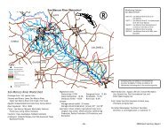
<strong>Guadalupe</strong> <strong>River</strong> Basin and USGS Gauge Sites<br />
Kerr<br />
Gillespie<br />
Fredericksburg<br />
<strong>Blanco</strong><br />
Hays<br />
Travis<br />
Austin<br />
Bastrop<br />
Real<br />
Leakey<br />
1 2 3 4<br />
Bandera<br />
5 Kendall<br />
Kerrville<br />
6<br />
Boerne<br />
Bandera<br />
<strong>Blanco</strong><br />
7<br />
Comal<br />
New Braunfels<br />
14<br />
15 Lockhart<br />
San Marcos<br />
17<br />
8 13 Caldwell<br />
10 9<br />
18<br />
11 <strong>Guadalupe</strong><br />
16<br />
Bastrop<br />
La Grange<br />
Fayette<br />
Seguin<br />
12<br />
Gonzales<br />
Hallettsville<br />
Wilson<br />
Gonzales<br />
19<br />
20<br />
Lavaca<br />
1. North Fork <strong>Guadalupe</strong> <strong>River</strong> near<br />
Hunt<br />
2. <strong>Guadalupe</strong> <strong>River</strong> at Hunt<br />
3. Johnson Creek near Ingram<br />
4. <strong>Guadalupe</strong> <strong>River</strong> above Bear Creek at<br />
Kerrville<br />
5. <strong>Guadalupe</strong> <strong>River</strong> at Comfort<br />
7. <strong>Guadalupe</strong> <strong>River</strong> near Spring Branch<br />
8. <strong>Guadalupe</strong> <strong>River</strong> at Sattler<br />
9. <strong>Guadalupe</strong> <strong>River</strong> above Comal <strong>River</strong><br />
at New Braunfels<br />
10. Comal <strong>River</strong> at New Braunfels<br />
11. <strong>Guadalupe</strong> <strong>River</strong> at New Braunfels<br />
12. <strong>Guadalupe</strong> <strong>River</strong> at Seguin*<br />
13. San Marcos <strong>River</strong> at San Marcos<br />
14. <strong>Blanco</strong> <strong>River</strong> at Wimberley<br />
15. <strong>Blanco</strong> <strong>River</strong> Near Kyle<br />
16. San Marcos <strong>River</strong> at Luling<br />
17. Plum Creek at Lockhart<br />
18. Plum Creek near Luling*<br />
Floresville<br />
Karnes City<br />
Karnes<br />
21<br />
DeWitt<br />
Goliad<br />
24<br />
Goliad<br />
22<br />
Cuero<br />
26 27<br />
Refugio<br />
19. <strong>Guadalupe</strong> <strong>River</strong> at Gonzales<br />
20. Peach Creek below Dilworth<br />
21. Sandies Creek near Westhoff<br />
22. <strong>Guadalupe</strong> <strong>River</strong> at Cuero<br />
23. <strong>Guadalupe</strong> <strong>River</strong> at Victoria<br />
24. Fifteenmile Creek near Weser<br />
25. Coleto Creek at Arnold Road near<br />
Schroeder<br />
26. Perdido Creek at Farm Road 622<br />
near Fannin<br />
27. Coleto Creek near Victoria<br />
28. <strong>Guadalupe</strong> <strong>River</strong> near<br />
Bloomington<br />
29. <strong>Guadalupe</strong> <strong>River</strong> near Tivoli<br />
25<br />
Refugio<br />
Victoria<br />
23<br />
28<br />
Victoria<br />
29<br />
Port Lavaca<br />
Calhoun<br />
*Near real-time data not available<br />
14
Gauge and/or Forecast Point<br />
Location<br />
Gauge Datum<br />
(mean sea level)<br />
North Fork <strong>Guadalupe</strong> <strong>River</strong> near Hunt<br />
<strong>Guadalupe</strong> <strong>River</strong> at Hunt<br />
Johnson Creek near Ingram<br />
<strong>Guadalupe</strong> <strong>River</strong> above Bear Creek near Kerrville<br />
<strong>Guadalupe</strong> <strong>River</strong> at Kerrville<br />
<strong>Guadalupe</strong> <strong>River</strong> at Comfort<br />
<strong>Guadalupe</strong> <strong>River</strong> near Spring Branch<br />
<strong>Guadalupe</strong> <strong>River</strong> at Sattler<br />
<strong>Guadalupe</strong> <strong>River</strong> above Comal <strong>River</strong> at New Braunfels<br />
Comal <strong>River</strong> at New Braunfels<br />
<strong>Guadalupe</strong> <strong>River</strong> at New Braunfels<br />
<strong>Guadalupe</strong> <strong>River</strong> at Seguin<br />
San Marcos <strong>River</strong> at San Marcos<br />
<strong>Blanco</strong> <strong>River</strong> at Wimberley<br />
<strong>Blanco</strong> <strong>River</strong> near Kyle<br />
San Marcos <strong>River</strong> at Luling<br />
Plum Creek at Lockhart<br />
Plum Creek near Luling<br />
<strong>Guadalupe</strong> <strong>River</strong> at Gonzales<br />
Peach Creek below Dilworth<br />
Sandies Creek near Westhoff<br />
<strong>Guadalupe</strong> <strong>River</strong> at Cuero<br />
<strong>Guadalupe</strong> <strong>River</strong> at Victoria<br />
Fifteenmile Creek near Weser<br />
Coleto Creek at Arnold Road near Schroeder<br />
Perdido Creek at Farm Road 622 near Fannin<br />
Coleto Creek near Victoria<br />
<strong>Guadalupe</strong> <strong>River</strong> near Bloomington<br />
<strong>Guadalupe</strong> <strong>River</strong> near Tivoli<br />
1,000 feet upstream of Ranch Road 1340<br />
56 feet upstream of SH 39 bridge<br />
1.3 mi downstream of Camp Scenic<br />
Arcadia Loop Road<br />
300 ft below Kerrville Dam<br />
Southbound bridge of IH 10<br />
Downstream side of bridge on Ranch Road 311<br />
200 ft upstream of Horseshoe Falls<br />
30 feet upstream of Common Street bridge<br />
200 feet upstream of San Antonio Street bridge<br />
Pepperell Mills Plant<br />
Starcke Park at Hwy 123<br />
Downstream side of bridge on Aquarena Springs Drive<br />
Downstream side of Ranch Road 12 bridge<br />
6.3 miles upstream of U.S. 81 bridge<br />
Downstream side of SH 80 bridge<br />
548 feet upstream of U.S. 183 bridge<br />
2.9 miles NE of Luling on County Rd. 128<br />
City Park, upstream of U.S. 183 bridge<br />
Hwy 90-A Bridge over Peach Creek<br />
100 feet downstream of Westhoff-Cheapside Road bridge<br />
Downstream side of U.S. 183 bridge<br />
Downstream side of U.S. 59 bridge<br />
Downstream end of U.S. 183 bridge<br />
Downstream side of Arnold Road crossing<br />
Downstream end of Farm Road 622 bridge<br />
Downstream side of westbound U.S. 59 bridge<br />
DuPont Plant<br />
Right bank of diversion at GBRA Salt Water Barrier<br />
1800.10 ft<br />
1722.70 ft<br />
1721.30 ft<br />
1623.20 ft<br />
1601.00 ft<br />
1369.83 ft<br />
948.10 ft<br />
742.24 ft<br />
586.65 ft<br />
582.80 ft<br />
572.55 ft<br />
455.30 ft<br />
557.67 ft<br />
797.23 ft<br />
620.12 ft<br />
322.05 ft<br />
431.19 ft<br />
321.57 ft<br />
231.80 ft<br />
213.53 ft<br />
178.27 ft<br />
128.64 ft<br />
29.15 ft<br />
158.40 ft<br />
100.43 ft<br />
134.66 ft<br />
44.18 ft<br />
0.00 ft<br />
0.04 ft<br />
Seguin Gazette-Enterprise<br />
CARS DO FLOAT. No amount<br />
of water is safe to drive<br />
through. Fast-moving floodwaters<br />
will carry away a vehicle<br />
that is moving. If it stalls,<br />
the water's momentum is<br />
transferred to the vehicle.<br />
Each foot of water equals 500<br />
pounds of lateral force, and<br />
1,500 pounds of buoyancy, so<br />
your vehicle weighs 1,500<br />
pounds less for each foot the<br />
water rises. Just two feet of<br />
water will carry away most<br />
automobiles.<br />
15
LOCAL AREA RADIO STATIONS<br />
Gonzales<br />
Kerrville<br />
Kerrville<br />
New Braunfels<br />
New Braunfels<br />
San Antonio<br />
San Antonio<br />
San Antonio<br />
San Antonio<br />
San Antonio<br />
San Antonio<br />
San Antonio<br />
San Antonio<br />
San Antonio<br />
San Antonio<br />
KCTI<br />
KERV<br />
KRVL<br />
KGNB<br />
KNBT<br />
KCJZ<br />
KCOR<br />
KCYY<br />
KDRY<br />
KEDA<br />
KISS<br />
KKYX<br />
KLEY<br />
KONO<br />
KROM<br />
106.3 FM/1450 AM<br />
1230 AM<br />
94.3 FM<br />
1420 AM<br />
92.1 FM<br />
106.7 FM<br />
1350 AM<br />
100 FM<br />
1100 AM<br />
1540 AM<br />
99.5 FM<br />
680 AM<br />
94.1 FM<br />
860 AM<br />
92.9 FM<br />
San Antonio<br />
San Antonio<br />
San Antonio<br />
San Antonio<br />
San Antonio<br />
San Antonio<br />
San Antonio<br />
San Antonio<br />
San Marcos<br />
Seguin<br />
Victoria<br />
Victoria<br />
Victoria<br />
Victoria<br />
KSJL<br />
KSMG<br />
KTKR<br />
KTSA<br />
KXTN<br />
KXXM<br />
KZEP<br />
WOAI<br />
KTSW<br />
KWED<br />
KAMG<br />
KPLV<br />
KVIC<br />
KVLT<br />
92.5 FM/810 AM<br />
101 FM<br />
760 AM<br />
550 AM<br />
107.5 FM<br />
96.1 FM<br />
104.5 FM<br />
1200 AM<br />
89.9 FM<br />
1580 AM<br />
1340 AM<br />
93.3 FM<br />
95.1 FM<br />
92.3 FM<br />
If a flood watch or warning is issued for your area:<br />
Remember that the safety of you and your family is the most important issue.<br />
Tune a battery-powered radio to a local station and follow all emergency instructions.<br />
Pack vehicles with your disaster kit, evacuation boxes and other valuables.<br />
Keep car keys on your person. Be prepared to evacuate before floodwaters reach your<br />
property.<br />
If trapped by rising flood waters, go to the second floor or the roof. Take warm clothing,<br />
a flashlight and a portable radio. If you have a cell phone, call for help and wait.<br />
ONLY IF time permits…..<br />
Turn off all utilities at the main power switch and close main gas valve. Don't<br />
touch any electrical equipment unless it is in a dry area.<br />
Move clothing, furniture and other contents to second floor, if available.<br />
Wipe bathtubs and sinks with bleach and fill with clean water. Your home may not<br />
flood and this will provide a water supply if local water plants are contaminated.<br />
Tie down outdoor furniture, garbage cans and tools or secure them in garage or<br />
other location.<br />
If an evacuation order is issued:<br />
Get out immediately.<br />
Don't attempt to walk through floodwaters at any level. They can hide hazards such<br />
as missing manhole covers, dangerous undercurrents and other risks.<br />
Go immediately to your vehicle(s) and leave by a safe evacuation route.<br />
Do not drive through ANY water, no matter how shallow it looks. The road may be<br />
washed out and it only takes a small amount of water to float a vehicle.<br />
If your car stalls in a flooded area, get out immediately and go to higher ground.<br />
Your life is more important than your car.<br />
When you get to a safe area, fill your gas tank. If electricity is cut off, gasoline<br />
pumps may not work.<br />
16
After a <strong>Flood</strong> - Rebuilding Your Life<br />
Being flooded is a traumatic experience. Give yourself time to heal. Investigate<br />
all your alternatives and do not make any major decisions until you understand all<br />
your options.<br />
Immediately call your flood insurance agent or broker. They will help you with claims,<br />
documenting damage and other procedures required by the National <strong>Flood</strong> Insurance<br />
Program.<br />
Local, state and federal agencies will set up offices to provide information about temporary<br />
housing and other available assistance.<br />
Do not return to your home until your local emergency officials have declared the area<br />
safe.<br />
Follow all instructions and procedures for entering and cleaning up flooded structures,<br />
disinfecting water and other public safety advisories.<br />
If you have a well, and the pump house, well or pressure tank is inundated by flood<br />
waters:<br />
Have your well water analyzed for bacterial quality by a certified laboratory before<br />
using it for household use, including drinking, bathing, and washing dishes and<br />
clothes.<br />
Disinfect your well by following the procedure to 'shock' a well provided by the<br />
TNRCC or the GBRA laboratory in our free brochure "Well Water <strong>Guide</strong>: Common<br />
Questions, Common Problems, Common Solutions."<br />
If necessary, replace your pressure tank if it has been contaminated by silt.<br />
Seguin Gazette-Enterprise<br />
17
Nonstructural Management<br />
Federal Insurance Programs<br />
There are two major reasons why the federal government created flood insurance programs.<br />
First, structural management simply cannot protect all areas at risk from<br />
flooding. Second, until Congress created the National <strong>Flood</strong> Insurance Program in 1968,<br />
it was almost impossible to obtain flood insurance. Private insurance firms were not willing<br />
to assume the huge financial risks involved in insuring against catastrophic flood<br />
losses. The NFIP, along with the <strong>Flood</strong> Disaster Protection Act of 1973 and the National<br />
<strong>Flood</strong> Insurance Reform Act of 1994 help ensure that you will be protected from financial<br />
losses caused by flooding.<br />
The National <strong>Flood</strong> Insurance Program<br />
The NFIP, which is administered by the Federal Emergency Management Agency<br />
(FEMA), makes it possible to purchase flood insurance at a reasonable cost. Backed by<br />
the U.S. Government, flood insurance is available to residents in more than 18,500 communities<br />
that currently participate in the NFIP.<br />
In 1999, the Texas Legislature passed House Bill 1018 which requires all counties<br />
and other jurisdictions in the State of Texas to join the NFIP by January 1, 2001.<br />
Counties will be responsible for implementing floodplain management within unincorporated<br />
areas. Cities and other jurisdictions will be responsible for floodplain management<br />
within their boundaries. In return, the NFIP agrees to make flood insurance coverage<br />
available to all residents of the participating communities, including those living in floodplains,<br />
provided those communities adopt and enforce floodplain management criteria to<br />
regulate development in identified flood-prone areas.<br />
Devastating floods occur throughout the U.S. every year. Changing weather patterns,<br />
combined with overdevelopment and clearing of land thereby reducing its natural ability<br />
to absorb water, are increasing the risk of flooding - even for people who don't live near<br />
water. <strong>Flood</strong>ing causes more than $2 billion in property damage each year and losses due<br />
to flooding are not covered under most homeowners or business policies. However,<br />
almost any enclosed building and its contents can be insured against loss from floods,<br />
flood-related erosion and flood-caused mudslides, if a community is participating in the<br />
NFIP.<br />
<strong>Flood</strong>plain Management<br />
Each participating jurisdiction must adopt a floodplain ordinance that regulates development<br />
within the 100-year floodplain, identified as the Special <strong>Flood</strong> Hazard Area on<br />
FEMA flood maps. <strong>Flood</strong> Hazard Boundary Maps and <strong>Flood</strong> Insurance Rate Maps, as well<br />
as information about your local floodplain management regulations, are available from<br />
<strong>Flood</strong>plain Administrators' offices listed on pages 22 and 23 of this booklet. Maps may<br />
also be purchased from FEMA by calling 1-800-358-9616.<br />
Communities may choose to adopt floodplain regulations that are highly restrictive,<br />
but all regulations must include the minimum requirements of the NFIP. The adopted<br />
ordinance names a <strong>Flood</strong>plain Administrator who is responsible for enforcing the ordinance<br />
and issuing floodplain development permits.<br />
18
These permits are mandatory for all new construction, as well as substantial improvements<br />
to existing structures. They also cover man-made alterations in the floodplain<br />
including dredging, filling, grading, paving, excavation or drilling operations, or storage<br />
of materials or equipment. Substantial improvement is defined as anything that costs<br />
50% or more of the market value of the building, before the improvement starts.<br />
Substantial damage is calculated the same way and applies to the structure before the<br />
damage took place.<br />
A floodplain is divided into two areas for regulatory purposes - the floodway and the<br />
flood fringe. The floodway includes the stream channel and adjoining over-bank area that<br />
would carry most of the dangerous, fast-moving waters of a 100-year flood. Because the<br />
floodway is so hazardous, floodplain regulations prohibit any development that would<br />
restrict the free flow of water. These obstructions would increase the depth and speed of<br />
already dangerous floodwaters.<br />
GBRA<br />
The portion of the floodplain outside the floodway is called the flood fringe, or floodway<br />
fringe. Since this area is usually confined to slow-moving or standing water, structures<br />
have a minor impact on flows. Development is allowed if buildings are raised to the<br />
base flood elevation. Nonresidential structures must be floodproofed to that elevation so<br />
water cannot enter the structure.<br />
Some floodplain ordinances require that structures be protected to an elevation that is<br />
higher than the 100-year flood level. This is called the flood protection elevation and<br />
offers additional safety for development in floodplains.<br />
19
Buying <strong>Flood</strong> Insurance<br />
If your community currently participates in the NFIP and has adopted floodplain regulations,<br />
flood insurance is available to all residents. These policies offer financial protection<br />
against flood losses and can be purchased for any building or its contents. <strong>Flood</strong><br />
insurance issued under the name of an insurance company is still federal flood insurance<br />
and is controlled by the regulations of the NFIP. Your insurance agent can answer any<br />
questions about your need for flood insurance, its availability in your community, and<br />
premium rates.<br />
You must have flood insurance to get secured financing to buy, build or improve<br />
structures in Special <strong>Flood</strong> Hazard Areas. This applies to conventional home mortgage<br />
loans, Federal Housing Administration (FHA) loans, Veterans Administration (VA) loans,<br />
second mortgages, home equity loans, home improvement loans, construction loans,<br />
commercial loans and farm credit loans.<br />
The law requires flood insurance in an amount equal to the outstanding principal balance<br />
of the loan, the value of the building, or the maximum limit of coverage available<br />
under the Act, whichever is less. It also requires flood insurance to be maintained for the<br />
life of the loan. Currently, up to $250,000 coverage is available for single-family residential<br />
buildings and $100,000 coverage is available for contents.<br />
You should also consider protecting your own equity by insuring your home or business<br />
to fully protect your property. Primary residences insured for 80% of their value, or<br />
the maximum amounts available, get replacement cost coverage. This pays the amount<br />
needed to repair or replace the building elements up to the policy limits, without deduction<br />
for depreciation.<br />
Non-participation<br />
Your county or local jurisdiction must join the NFIP by January 1, 2001. Until then,<br />
there are non-participation consequences that will affect your community. First, flood<br />
insurance will not be available within the jurisdiction. Second, loans, federal grants or<br />
mortgage insurance will not be available for structures within Special <strong>Flood</strong> Hazard Areas,<br />
including funding from the Federal Housing Administration (FHA), Farmers Home<br />
Administration (FMHA), Veterans Administration (VA) and the Small Business<br />
Administration (SBA). Third, no federal disaster assistance will be available for buildings<br />
located in the identified 100-year floodplain after a flood disaster. Lenders would be permitted<br />
to make conventional loans for structures in Special <strong>Flood</strong> Hazard Areas.<br />
However, they would have to inform the buyer in writing that the property is located in a<br />
Special <strong>Flood</strong> Hazard Area and that no disaster assistance would be available in the event<br />
of another flood. For these reasons, it is important that counties and jurisdictions join<br />
the NFIP as soon as possible.<br />
20
Where to Get More Information:<br />
Federal Emergency Management Agency<br />
Region VI, Denton, Texas (covers Arkansas, Louisiana, New Mexico, Oklahoma and<br />
Texas).<br />
Main Number: (940) 898-5399<br />
<strong>Flood</strong> Insurance: (800) 427-4661<br />
Map Service Center: (800) 358-9616<br />
Headquarters: Washington, D.C. 20472.<br />
Main Number: (888)-CALL-FLOOD ext. 314<br />
Website at http://www.fema.gov offers links to general information, maps, disaster<br />
assistance, prevention/mitigation, flood insurance and various other topics.<br />
<strong>Guadalupe</strong>-<strong>Blanco</strong> <strong>River</strong> <strong>Authority</strong><br />
933 East Court Street, Seguin, TX 78155<br />
Main Number: (830) 379-5822<br />
Website at http://www.gbra.org offers information about GBRA, news releases, links to<br />
other river authorities, state and federal agencies, water quality data and consumer<br />
confidence water quality reports, lab reports and many other areas.<br />
National Oceanic and Atmospheric Administration (NOAA)<br />
Website at http://www.noaa.gov offers links to departments including the National<br />
Weather Service, on-line photo archive, oceanic information, fisheries, and other subjects.<br />
United States Geological Survey (USGS)<br />
Website at http://txwww.cr.usgs.gov/nwis-bin/current.html offers information about<br />
current hydrologic conditions in Texas including river flows, gauges and historic<br />
streamflow data.<br />
21
<strong>Flood</strong>plain Administrators<br />
Your local <strong>Flood</strong>plain Administrator is responsible for floodplain management regulations<br />
and can provide information about your community's program. Listed below<br />
are offices and telephone numbers for <strong>Flood</strong>plain Administrators in the <strong>Guadalupe</strong>-<strong>Blanco</strong><br />
<strong>River</strong> <strong>Authority</strong>'s ten-county statutory district.<br />
Caldwell County<br />
(512) 398-2213<br />
Lockhart<br />
(512) 398-3461<br />
Luling<br />
(830) 875-2481<br />
Martindale<br />
(512) 357-6700<br />
Calhoun County<br />
(361) 553-4455<br />
Point Comfort<br />
(361) 552-0996<br />
Port Lavaca<br />
(361) 552-9795<br />
Seadrift<br />
(361) 785-2251<br />
Comal County<br />
(830) 608-2090<br />
Bulverde<br />
(830) 438-3612<br />
Garden Ridge<br />
(210) 651-6632<br />
New Braunfels<br />
(830) 608-2100<br />
De Witt County<br />
(361) 275-8307<br />
Cuero<br />
(361) 275-6114<br />
Yorktown<br />
(361) 564-2611<br />
Nordheim<br />
(361) 938-5223<br />
Gonzales County<br />
(830) 672-2327<br />
Gonzales<br />
(830) 672-2815<br />
Nixon<br />
(830) 582-1924<br />
Waelder<br />
(830) 665-7331<br />
<strong>Guadalupe</strong> County<br />
(830) 303-4188 X251<br />
Cibolo<br />
(210) 658-9900<br />
Marion<br />
(830) 420-2391<br />
Schertz<br />
(210) 658-7477<br />
Seguin<br />
(830) 401-2436<br />
Hays County<br />
(512) 353-4351<br />
Bear Creek<br />
(512) 301-3213<br />
Buda<br />
(512) 295-6331<br />
Dripping Springs<br />
(512) 858-4725<br />
Hays<br />
(512) 295-4761<br />
22
<strong>Flood</strong>plain Administrators, Continued<br />
Kyle<br />
(512) 268-5341<br />
Mountain City<br />
(512) 268-4051<br />
Niederwald<br />
(512) 376-5695<br />
San Marcos<br />
(512) 353-4444<br />
Uhland<br />
(512) 398-6700<br />
Woodcreek<br />
(512) 847-9390<br />
Kendall County<br />
(830) 249-9343<br />
Boerne<br />
(830) 249-9511<br />
Refugio County<br />
(361) 526-4434<br />
Austwell<br />
(361) 286-3523<br />
Bayside<br />
(361) 529-6644<br />
Refugio<br />
(361) 526-5361<br />
Woodsboro<br />
(361) 543-4505<br />
Victoria County<br />
(361) 576-1031<br />
Victoria<br />
(361) 572-2722<br />
Peggy Smith, Victoria County<br />
23