Air Navigation Pro 5.2 User Manual - Xample
Air Navigation Pro 5.2 User Manual - Xample
Air Navigation Pro 5.2 User Manual - Xample

Create successful ePaper yourself
Turn your PDF publications into a flip-book with our unique Google optimized e-Paper software.
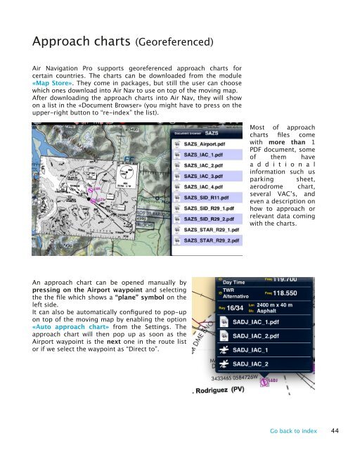
Approach charts (Georeferenced)<br />
<strong>Air</strong> <strong>Navigation</strong> <strong>Pro</strong> supports georeferenced approach charts for<br />
certain countries. The charts can be downloaded from the module<br />
«Map Store». They come in packages, but still the user can choose<br />
which ones download into <strong>Air</strong> Nav to use on top of the moving map.<br />
After downloading the approach charts into <strong>Air</strong> Nav, they will show<br />
on a list in the «Document Browser» (you might have to press on the<br />
upper-right button to “re-index” the list).<br />
Most of approach<br />
charts files come<br />
with more than 1<br />
PDF document, some<br />
of them have<br />
a d d i t i o n a l<br />
information such us<br />
parking sheet,<br />
aerodrome chart,<br />
several VAC’s, and<br />
even a description on<br />
how to approach or<br />
relevant data coming<br />
with the charts.<br />
An approach chart can be opened manually by<br />
pressing on the <strong>Air</strong>port waypoint and selecting<br />
the the file which shows a “plane” symbol on the<br />
left side.<br />
It can also be automatically configured to pop-up<br />
on top of the moving map by enabling the option<br />
«Auto approach chart» from the Settings. The<br />
approach chart will then pop up as soon as the<br />
<strong>Air</strong>port waypoint is the next one in the route list<br />
or if we select the waypoint as “Direct to”.<br />
Go back to index 44