Air Navigation Pro 5.2 User Manual - Xample
Air Navigation Pro 5.2 User Manual - Xample
Air Navigation Pro 5.2 User Manual - Xample

You also want an ePaper? Increase the reach of your titles
YUMPU automatically turns print PDFs into web optimized ePapers that Google loves.
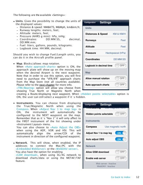
The following are the available «Settings»:<br />
• Units. Gives the possibility to change the units of<br />
the displayed values:<br />
- Distance & speed: NM&KTS, M&Mph, km&km/h;<br />
- Runway lengths: meters, feet;<br />
- Altitude: meters, feet;<br />
- Pressure (AHRS g mini): hPa, inHg;<br />
- Coordinates: DD:MM:SS, decimal,<br />
DD:MM.mm;<br />
- Fuel: liters, gallons, pounds, kilograms.<br />
- Logbook time: HH:MM, decimal.<br />
Should you wish to change Fuel/Length units, you<br />
can do it in the <strong>Air</strong>craft profile panel.<br />
• Map. Blocks/allows map rotation.<br />
When «Auto approach charts» option is ON, the<br />
approach plate will show up on the moving map<br />
when the desired <strong>Air</strong>port is the next waypoint.<br />
Note that in order to use this option, you will first<br />
need to purchase the “VFR/IFR” approach charts<br />
from the Map Store (not all countries available).<br />
Please refer to the next chapter for more info.<br />
«TRK/Bearing» option will allow you choose from<br />
showing True North or Magnetic North when<br />
creating a Route/displaying next waypoint. When «Hidden points selectable» option is<br />
ON, the user can still select a waypoint if it`s hidden.<br />
• Instruments. You can choose from displaying<br />
the True/Magnetic North when using the<br />
Compass. When «Adjust Nav 1 to map leg» is<br />
ON, the instrument will automatically be<br />
configured to the NEXT waypoint on the map.<br />
Remember that as it`s “Nav 1” it will only affect to<br />
the FIRST instrument of the list showing under<br />
«Instrument Layout» menu.<br />
You can also choose to «Auto Adjust the OBS»<br />
when using the ADF, VOR and HSI. This will<br />
automatically align the arrow/CDI of the<br />
instrument in direction of the configured waypoint.<br />
• Network. This will show, when enabled, the IP<br />
addesses to connect the Mac/PC with the<br />
«Embedded WebServer» or the «W ebDAV server».<br />
You also have the option for enabling<br />
«GSM download», when using 3G/4G network to<br />
download charts/data or using the METAF/TAF<br />
feature.<br />
Go back to index 12