Geological Aspect of the Problem Dating the Great Egyptian Sphinx
Geological Aspect of the Problem Dating the Great Egyptian Sphinx
Geological Aspect of the Problem Dating the Great Egyptian Sphinx

You also want an ePaper? Increase the reach of your titles
YUMPU automatically turns print PDFs into web optimized ePapers that Google loves.
Geoarchaeology and Archaeomineralogy (Eds. R. I. Kostov, B. Gaydarska, M. Gurova). 2008.<br />
Proceedings <strong>of</strong> <strong>the</strong> International Conference, 29-30 October 2008 S<strong>of</strong>ia, Publishing House “St. Ivan Rilski”, S<strong>of</strong>ia, 308-311.<br />
GEOLOGICAL ASPECT OF THE PROBLEM OF DATING THE GREAT EGYPTIAN SPHINX<br />
CONSTRUCTION<br />
Vjacheslav I. Manichev 1 , Alexander G. Parkhomenko 2<br />
1 Institute <strong>of</strong> Environmental Geochemistry, National Academy <strong>of</strong> Sciences <strong>of</strong> Ukraine, 34a Palladin Av., 03680 Kyiv, Ukraine;<br />
igns@i.com.ua<br />
2 Institute <strong>of</strong> Geography, National Academy <strong>of</strong> Sciences <strong>of</strong> Ukraine, 44 Volodymyrska Str., 01034 Kyiv, Ukraine; geo-ins@kiev.ldc.net<br />
ABSTRACT. The problem <strong>of</strong> dating <strong>the</strong> <strong>Great</strong> <strong>Egyptian</strong> <strong>Sphinx</strong> construction is still valid, despite <strong>of</strong> <strong>the</strong> long-term history <strong>of</strong> its research. <strong>Geological</strong><br />
approach in connection to o<strong>the</strong>r scientific-natural methods permits to answer <strong>the</strong> question about <strong>the</strong> relative age <strong>of</strong> <strong>the</strong> <strong>Sphinx</strong>. The conducted<br />
visual investigation <strong>of</strong> <strong>the</strong> <strong>Sphinx</strong> allowed <strong>the</strong> conclusion about <strong>the</strong> important role <strong>of</strong> water from large water bodies which partially flooded <strong>the</strong><br />
monument with formation <strong>of</strong> wave-cut hollows on its vertical walls. The morphology <strong>of</strong> <strong>the</strong>se formations has an analogy with similar such hollows<br />
formed by <strong>the</strong> sea in <strong>the</strong> coastal zones. Genetic resemblance <strong>of</strong> <strong>the</strong> compared erosion forms and <strong>the</strong> geological structure and petrographic<br />
composition <strong>of</strong> sedimentary rock complexes lead to a conclusion that <strong>the</strong> decisive factor <strong>of</strong> destruction <strong>of</strong> <strong>the</strong> historic monument is <strong>the</strong> wave energy<br />
ra<strong>the</strong>r than sand abrasion in Eolian process. Voluminous geological literature confirms <strong>the</strong> fact <strong>of</strong> existence <strong>of</strong> long-living fresh-water lakes in<br />
various periods <strong>of</strong> <strong>the</strong> Quaternary from <strong>the</strong> Lower Pleistocene to <strong>the</strong> Holocene. These lakes were distributed in <strong>the</strong> territories adjacent to <strong>the</strong> Nile.<br />
The absolute mark <strong>of</strong> <strong>the</strong> upper large erosion hollow <strong>of</strong> <strong>the</strong> <strong>Sphinx</strong> corresponds to <strong>the</strong> level <strong>of</strong> water surface which took place in <strong>the</strong> Early<br />
Pleistocene. The <strong>Great</strong> <strong>Egyptian</strong> <strong>Sphinx</strong> had already stood on <strong>the</strong> Giza Plateau by that geological (historical) time.<br />
In <strong>the</strong> recent years one could observe <strong>the</strong> growth <strong>of</strong> interest<br />
in dating <strong>the</strong> construction <strong>of</strong> <strong>the</strong> <strong>Great</strong> <strong>Egyptian</strong> <strong>Sphinx</strong> (GES),<br />
which is determined, to a considerable extent, by new ideas<br />
about geological factors which could influence its safety. In<br />
view <strong>of</strong> ano<strong>the</strong>r interpretation <strong>of</strong> <strong>the</strong> geological and naturegeographical<br />
data <strong>the</strong> historical-archaeological method for<br />
determining <strong>the</strong> GES age (about 5000 years old) can prove to<br />
be unfounded. The authors <strong>of</strong> <strong>the</strong> report have ano<strong>the</strong>r point <strong>of</strong><br />
view in considering <strong>the</strong> problem. We have taken <strong>the</strong> GES age<br />
such as it was indicated by <strong>the</strong>osophist Yelena Blavatskaya in<br />
one <strong>of</strong> her basic works (1937). She wrote: “Notice <strong>the</strong><br />
indestructible witness <strong>of</strong> evolution <strong>of</strong> Human races, from<br />
Divine, and especially Androgynous race, <strong>the</strong> <strong>Egyptian</strong> <strong>Sphinx</strong>,<br />
that mystery <strong>of</strong> centuries”. According to Blavatskaya <strong>the</strong> time <strong>of</strong><br />
GES erection should exceed 750000 years. Are <strong>the</strong>re some<br />
geological indications which are evidence for such an old age<br />
<strong>of</strong> <strong>the</strong> <strong>Sphinx</strong> Consider <strong>the</strong> brief prehistory <strong>of</strong> <strong>the</strong> problem.<br />
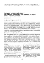
The sand abrasion which resulted in formation <strong>of</strong> deep<br />
horizontal hollows all over <strong>the</strong> monument parameter (Fig. 1-2)<br />
is considered conventional in estimating <strong>the</strong> factors which<br />
influenced <strong>the</strong> GES. Maximum depth <strong>of</strong> those hollows reaches<br />
8 feet (above 2 meters). Geologists who studied <strong>Sphinx</strong> are<br />
sure that <strong>the</strong> hollows had formed at <strong>the</strong> expense <strong>of</strong><br />
comparatively loose mountain rocks, while <strong>the</strong> protrusions<br />
between <strong>the</strong>m are more hard rocks resistant to <strong>the</strong> influence <strong>of</strong><br />
winds. They think that <strong>the</strong> period <strong>of</strong> 5000 years is sufficient for<br />
creating such large hollows by Eolian process. But <strong>the</strong>y cannot<br />
answer <strong>the</strong> question, about <strong>the</strong> absence <strong>of</strong> such forms <strong>of</strong><br />
wea<strong>the</strong>ring on <strong>the</strong> front part <strong>of</strong> <strong>the</strong> head.<br />
Fig. 1. Horizontal hollows <strong>of</strong> <strong>Sphinx</strong> (Drevnii Egipet, 2005)<br />
Fig. 2. A fragment <strong>of</strong> <strong>the</strong> hollow in <strong>the</strong> back part <strong>of</strong> <strong>the</strong> <strong>Sphinx</strong><br />
308
A new point <strong>of</strong> view, concerning <strong>the</strong> age <strong>of</strong> <strong>the</strong> <strong>Sphinx</strong>, has<br />
appeared recently. It belongs to geologist R. Schoch (2005);<br />
he has found traces <strong>of</strong> water on <strong>the</strong> surface <strong>of</strong> <strong>the</strong> GES. He<br />
supposes that <strong>the</strong> problem is in <strong>the</strong> rain water. Climatic<br />
conditions characterized by high humidity and pouring rains<br />
may have taken place 13000 years BC. But even this age<br />
border, is not <strong>the</strong> date <strong>of</strong> construction, since <strong>the</strong> <strong>Sphinx</strong> had<br />
already been standing in <strong>the</strong> Giza Plateau by <strong>the</strong> beginning <strong>of</strong><br />
<strong>the</strong> period <strong>of</strong> pouring rains.<br />
In order to study <strong>the</strong> geological situation and to specify <strong>the</strong><br />
role <strong>of</strong> possible factors for <strong>the</strong> destruction <strong>of</strong> GES, one <strong>of</strong> <strong>the</strong><br />
authors <strong>of</strong> this report has made a visual investigation <strong>of</strong> <strong>the</strong><br />
monument on <strong>the</strong> spot (in <strong>the</strong> Republic <strong>of</strong> Egypt). After a<br />
detailed analysis <strong>of</strong> <strong>the</strong> GES surface morphology and after<br />
reading <strong>the</strong> literary sources we have come to a conclusion that<br />
<strong>the</strong> statement about <strong>the</strong> influence <strong>of</strong> sand abrasion on <strong>the</strong> root<br />
rocks <strong>of</strong> <strong>the</strong> monument is exaggerated.<br />
In our geological field expeditions in different mountains and<br />
littoral zones <strong>of</strong> <strong>the</strong> Crimea and Caucasus we could <strong>of</strong>ten<br />
observe <strong>the</strong> forms <strong>of</strong> Eolian wea<strong>the</strong>ring which morphology<br />
differs considerably from <strong>the</strong> wea<strong>the</strong>ring taking place on <strong>the</strong><br />
GES. Most natural forms <strong>of</strong> wea<strong>the</strong>ring are <strong>of</strong> smoo<strong>the</strong>d<br />
character, independent <strong>of</strong> lithological composition <strong>of</strong> <strong>the</strong> rocks.<br />
Our personal experience in scientific investigation <strong>of</strong> geology<br />
<strong>of</strong> <strong>the</strong> sea coasts gives reasons to draw an analogy with <strong>the</strong><br />
GES and to suggest ano<strong>the</strong>r mechanism <strong>of</strong> its destruction.<br />
Specialists-geologists, who work in <strong>the</strong> field <strong>of</strong> sea-coast<br />
geomorphology, know such forms <strong>of</strong> relief as wave-cut hollows<br />
(Morskaya Geomorfologiya, 1980). They can be one- and<br />
multi-storey. They are arranged horizontally to <strong>the</strong> sea water<br />
surface, if <strong>the</strong> coast makes a vertical wall (cliff). Especially<br />
deep wave-cut hollows are formed in precipitous cliffs built by<br />
<strong>the</strong> strata <strong>of</strong> carbonaceous rocks. Such forms <strong>of</strong> <strong>the</strong> coast<br />
relief are well-known and studied in detail on <strong>the</strong> Black-Sea<br />
coast <strong>of</strong> <strong>the</strong> Caucasus and Crimea (Popov, 1953; Zenkovich,<br />
1960). General model <strong>of</strong> formation <strong>of</strong> <strong>the</strong> wave-cut hollows in<br />
<strong>the</strong> rocks <strong>of</strong> <strong>the</strong> Caucasian flysch is given by Popov (1953,<br />
162; Fig. 3).<br />
In dynamics <strong>of</strong> <strong>the</strong> process <strong>of</strong> wave-cut hollows formation<br />
one can notice such a characteristic feature that <strong>the</strong> wave<br />
energy is directed to <strong>the</strong> rock stratum at <strong>the</strong> level <strong>of</strong> water<br />
surface. Besides, both saline and fresh water can dissolve <strong>the</strong><br />
rocks.<br />
Tseiner (1963) noticed that underwashing <strong>of</strong> <strong>the</strong> coastal<br />
walls with formation <strong>of</strong> hollows is an important erosion<br />
indication which may be used for defining <strong>the</strong> old shoreline.<br />
The hollow altitude relative to <strong>the</strong> sea level in <strong>the</strong> time <strong>of</strong><br />
formation varies depending on <strong>the</strong> water surface level. The<br />
hollows altitude can also correspond to <strong>the</strong> upper water mark.<br />
Under natural conditions <strong>the</strong> levels <strong>of</strong> water-cut hollows can be<br />
both above and below <strong>the</strong> water surface. The water-cut<br />
hollows are formed, as a rule, under transgression, i.e. under<br />
sea tide. The transport <strong>of</strong> <strong>the</strong> horizontal sea water surface<br />
occurs both gradually and discontinuously, and <strong>the</strong> hollow<br />
formation lasts for hundreds and even thousands <strong>of</strong> years. An<br />
analogy with wave-cut hollows gives reasons to think that <strong>the</strong><br />
formation <strong>of</strong> <strong>the</strong> GES hollows took place under its long-term<br />
submersion in high water. The Nile seasonal floods could not<br />
play any considerable part.<br />
Limestones, dolomite limestones with small interlayers <strong>of</strong><br />
clay (Rushdi, 1965) <strong>of</strong> Eocene age prevailed in <strong>the</strong> geological<br />
structure <strong>of</strong> <strong>the</strong> GES. These rocks possess different degree <strong>of</strong><br />
resistance to <strong>the</strong> wave effect. If <strong>the</strong> hollows formation were due<br />
to sand abrasion only, <strong>the</strong> hollows had to correspond to <strong>the</strong><br />
strata <strong>of</strong> a certain lithological composition. The GES hollows<br />
are formed in fact within several strata, or occupy some part <strong>of</strong><br />
<strong>the</strong> stratum <strong>of</strong> homogeneous composition (Fig. 4).<br />
The formation <strong>of</strong> wave-cut hollows in <strong>the</strong> massif <strong>of</strong> rocks<br />
composing <strong>the</strong> GES was a process directed from <strong>the</strong> bottom to<br />
<strong>the</strong> top, which means <strong>the</strong> adjustment <strong>of</strong> <strong>the</strong> highest deep<br />
hollow to <strong>the</strong> maximum level <strong>of</strong> <strong>the</strong> monument submersion<br />
(Fig. 5). The back part <strong>of</strong> <strong>the</strong> head and <strong>the</strong> body surface were<br />
in <strong>the</strong> zone <strong>of</strong> <strong>the</strong> least effect <strong>of</strong> waves but <strong>the</strong> waves left <strong>the</strong>ir<br />
traces even <strong>the</strong>re (rain traces, according to Schoch).<br />
The absolute mark <strong>of</strong> <strong>the</strong> territory in <strong>the</strong> Giza Plateau region<br />
(149 m above <strong>the</strong> present sea level from <strong>the</strong> data <strong>of</strong> physicalgeographical<br />
map <strong>of</strong> Egypt, 1965) as well as <strong>the</strong> mark <strong>of</strong> <strong>the</strong><br />
upper deep hollow from <strong>the</strong> GES foot being allowed for; it<br />
would be about 160 m above <strong>the</strong> present sea level. In this<br />
connection <strong>the</strong>re arises a question, when could have <strong>the</strong> GES<br />
been submerged and what kind <strong>of</strong> water body it was.<br />
Geologists <strong>of</strong> <strong>the</strong> Republic <strong>of</strong> Egypt (Rushdi, 1965) and o<strong>the</strong>r<br />
countries have established, when studying <strong>the</strong> sedimentary<br />
series adjoining <strong>the</strong> Giza Plateau, that from <strong>the</strong> end <strong>of</strong> Pliocene<br />
<strong>the</strong> lacustrine deposits represented by alluvium <strong>of</strong>ten occurred<br />
<strong>the</strong>re. They had considerable thickness in geological crosssections<br />
and covered vast territories.<br />
Fig. 3. Scheme <strong>of</strong> development <strong>of</strong> wave-cut hollows in <strong>the</strong> rocks <strong>of</strong> <strong>the</strong><br />
Caucasian flysch (Popov, 1953)<br />
Fig. 4. A fragment <strong>of</strong> <strong>the</strong> <strong>Sphinx</strong> surface composed by <strong>the</strong> rocks <strong>of</strong><br />
various lithological compositions<br />
309
All <strong>the</strong> following phases differed by wavy lowering <strong>of</strong> <strong>the</strong> sea<br />
level marks. It is <strong>the</strong> sea level during <strong>the</strong> Calabrian phase<br />
which is <strong>the</strong> closest to <strong>the</strong> present mark with <strong>the</strong> highest GES<br />
hollow at its level. High level <strong>of</strong> sea water also caused <strong>the</strong> Nile<br />
overflowing and created long-living water-bodies. As to time it<br />
corresponds to 800000 years.<br />
After <strong>the</strong> completion <strong>of</strong> lacustrine (fresh water) stage in <strong>the</strong><br />
GES life o<strong>the</strong>r natural processes superimpose <strong>the</strong> vertical GES<br />
pr<strong>of</strong>ile formed by water, especially at <strong>the</strong> stage <strong>of</strong> desert<br />
climate development. The sand abrasion (Eolian in a broad<br />
sense) was directed to smoothing <strong>the</strong> contrast forms and led to<br />
even greater destruction <strong>of</strong> <strong>the</strong> monument.<br />
Fig. 5. The upper hollow <strong>of</strong> <strong>the</strong> <strong>Sphinx</strong> (white arrow)<br />
It follows from <strong>the</strong> investigations <strong>of</strong> <strong>the</strong> substance<br />
composition <strong>of</strong> rocks in geological cross-sections that <strong>the</strong>y<br />
were deposits <strong>of</strong> fresh-water reservoirs, lakes supplied with <strong>the</strong><br />
Nile waters. The Nile ran at a higher level at that time. The<br />
Pleistocene lakes occupied <strong>the</strong> territory <strong>of</strong> <strong>the</strong> present Birket-<br />
Karun Lake at least ten times (Rushdi, 1965, 89). Tools <strong>of</strong><br />
ancient people were found in <strong>the</strong>se lacustrine deposits.<br />
Chumakov (1965; 1967) in his works dedicated to <strong>the</strong><br />
Pliocene and Pleistocene deposits <strong>of</strong> <strong>the</strong> Nile Valley also<br />
comes to a conclusion about <strong>the</strong> broad development <strong>of</strong><br />
lacustrine deposits. He notes that in <strong>the</strong> Late Pliocene <strong>the</strong> sea<br />
waters began penetrating <strong>the</strong> Nile Valley and its level rose.<br />
That led to formation <strong>of</strong> lacustrine deposits which are at <strong>the</strong><br />
mark <strong>of</strong> 180 m above <strong>the</strong> present level <strong>of</strong> <strong>the</strong> Mediterranean<br />
Sea. The lacustrine deposits are also known in <strong>the</strong> Fajum<br />
depression.<br />
In his large generalizing work Tseiner (1963) presents results<br />
from <strong>the</strong> analysis <strong>of</strong> measuring <strong>the</strong> levels <strong>of</strong> <strong>the</strong> coastal<br />
terraces <strong>of</strong> <strong>the</strong> African coast <strong>of</strong> <strong>the</strong> Mediterranean Sea,<br />
regularly distributed in time from <strong>the</strong> Pleistocene to <strong>the</strong><br />
Holocene. Based on <strong>the</strong> obtained data, <strong>the</strong> author has made a<br />
plot with distinguishing certain phases, which corresponded to<br />
absolute marks <strong>of</strong> Sea levels and time intervals (Fig. 6). As is<br />
seen from <strong>the</strong> figure, <strong>the</strong> highest mark <strong>of</strong> <strong>the</strong> Mediterranean<br />
Sea level took place during <strong>the</strong> Calabrian phase and was<br />
above 160 m relative to <strong>the</strong> present sea level.<br />
Fig. 6. Curve <strong>of</strong> <strong>the</strong> ocean level change during <strong>the</strong> Pleistocene from <strong>the</strong><br />
data <strong>of</strong> <strong>the</strong> Mediterranean Sea terraces (Tseiner, 1963). Levels: 1 –<br />
Calabrian, II – Sicilian, III – Milan, IV – Tirranian, V – Monastery.<br />
Conventional signs: along <strong>the</strong> vertical axis – meters; along <strong>the</strong> horizontal<br />
axis – thousands <strong>of</strong> years<br />
The suggested hypo<strong>the</strong>sis concerning <strong>the</strong> relative dating <strong>of</strong><br />
GES erection is based on <strong>the</strong> analogy with natural processes<br />
known in marine geology and explains <strong>the</strong> formation <strong>of</strong> hollows<br />
in <strong>the</strong> <strong>Sphinx</strong> as wave-cut ones. Fur<strong>the</strong>r necessity <strong>of</strong> studying<br />
<strong>the</strong> substance composition <strong>of</strong> <strong>the</strong> GES rocks with <strong>the</strong> purpose<br />
<strong>of</strong> a detailed lithological-mineralogical research can be<br />
suggested.<br />
If <strong>the</strong> world geological science will succeed in studying all <strong>the</strong><br />
disputable GES aspects connected with <strong>the</strong> time <strong>of</strong> its<br />
construction and in proving an earlier age <strong>of</strong> construction, than<br />
<strong>the</strong> Old Egypt civilization, it will lead to new comprehension <strong>of</strong><br />
history, and as a result, to reveal true motive forces <strong>of</strong> <strong>the</strong><br />
intellectual development <strong>of</strong> civilization.<br />
Conclusion<br />
A comparison <strong>of</strong> <strong>the</strong> formation <strong>of</strong> wave-cut hollows on <strong>the</strong><br />
sea coasts with erosion structures in <strong>the</strong> form <strong>of</strong> hollows<br />
observed on <strong>the</strong> surface <strong>of</strong> <strong>the</strong> <strong>Great</strong> <strong>Egyptian</strong> <strong>Sphinx</strong> permits<br />
a conclusion about <strong>the</strong> similarity <strong>of</strong> <strong>the</strong> formation mechanism. It<br />
is connected to water activity in large water bodies during <strong>the</strong><br />
<strong>Sphinx</strong> submersion for a long period <strong>of</strong> time. <strong>Geological</strong> data<br />
from literary sources can suggest a possible <strong>Sphinx</strong><br />
submersion in <strong>the</strong> Early Pleistocene, and its initial construction<br />
is believed to date from <strong>the</strong> time <strong>of</strong> most ancient history.<br />
References<br />
Arabskaya Respublika Egipet. Obshtegeograficheskaya Karta.<br />
1976. 4th Ed., GUGK, Moscow (in Russian).<br />
Blavatskaya, Ye. L. 1937. Tainaya Doktriona. Vol. 2. Uguns,<br />
Riga, 1008 p. (in Russian)<br />
Chumakov, I. S. 1965. Pliotsenovie ingressii v dolinu Nila. –<br />
Byulleten MOIP, Novaya Seriya, Otd. Geol., 40, 4 (in<br />
Russian).<br />
Chumakov, I. S. 1967. Pliotsenovie I Pleistotsenovie<br />
otlozheniya dolini Nila v Nustii i Verhnom Egipte. – Trudi<br />
Geol. Inst. AN SSSR, 170, 115 p. (in Russian)<br />
Drevnii Egipet. Encyclopedia. 2005. ART-Rodnik, Moscow, 479<br />
p. (in Russian)<br />
Fisiko-geograficheskaya Karta Respubliki Egipet. GUGK,<br />
Moscow (in Russian).<br />
Morskaya Geomorfologiya. Terminologicheskii Spravochnik.<br />
1980. Мisl, Moscow, 280 p. (in Russian)<br />
Popov, Е. А. 1953. Formi Abrazii Beregov, Slozhennie<br />
Flishevimi Porodami. Vol. 7. Trudi Inst. Okeanologii AN<br />
SSSR, Moscow, 160-166 (in Russian).<br />
Rushdi, S. 1965. Geology <strong>of</strong> Egypt. Mir, Moscow, 276 p. (in<br />
Russian)<br />
310
Schoch, R. (with R. A. McNally). 2005. Pyramid Quest:<br />
Secrets <strong>of</strong> <strong>the</strong> <strong>Great</strong> Pyramid and <strong>the</strong> Dawn <strong>of</strong> Civilization.<br />
J. P. Tarcher, Putnam.<br />
Tseiner, F. 1963. Pleistocen. Izd. Inostrannoi Literaturi,<br />
Моscow, 502 p. (in Russian)<br />
Zenkovich, V. P. 1960. Morfologiya i Dinamika Sovetskih<br />
Beregov Chernogo Morya. Vol. II. Izv. AN SSSR, Moscow,<br />
216 p. (in Russian)<br />
Zenkovich, V. P. 1962. Osnovi Ucheniya o Razvitiya Morskikh<br />
Beregov. AN SSSR, Moscow, 710 p. (in Russian)<br />
311