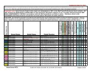
Staff Reports - East Bay Municipal Utility District
Staff Reports - East Bay Municipal Utility District
Staff Reports - East Bay Municipal Utility District

Create successful ePaper yourself
Turn your PDF publications into a flip-book with our unique Google optimized e-Paper software.
The land referred to is situated in the County of Contra Costa, City of Lafayette, State of<br />
California, and is described as follows:<br />
Portion of the Rancho Booa de la Canada del Pinole, described as follows:<br />
Beginning on the Southeastern line of Mount Diablo Boulevard at the Northeastern comer of the<br />
Parcel of land described as Parcel Two in the Deed from Pat LaRocca, et ux, to C. Leroy Wolff,<br />
dated March 11, 1947, recorded July 9, 1947, in Book 1094 of Official Records, Page 566;<br />
thence from said point of beginning, South 12° 02' 55" <strong>East</strong>, 253.47 feet to the Southeastern<br />
corner of said Wolff Parcel; thence South 65° 43' West along the Southeastern line of said Wolff<br />
Parcel a distance of 55 feet; thence Northerly in a straight line to a point on the Southeastern<br />
line of said Mount Diablo Boulevard, which is distant thereon South 65° 43' West, 60 feet from<br />
the Northeastern corner of said Wolff Parcel; thence North 65° 43' <strong>East</strong> along the Southeastern<br />
line of said Boulevard and the Northwestern line of said Wolff Parcel a distance of 60 feet to the<br />
point of beginning.<br />
EXCEPTING THEREFROM<br />
Commencing on the Southeast line of Mt. Diablo Boulevard at the Northeast corner of the<br />
Parcel of land described in the Deed from C. Le Roy Wolff to <strong>East</strong> bay municipal utility district,<br />
dated May 7, 1952, and recorded June 6,1952, in Book 1942, at page 466, Contra Costa<br />
County Records; thence from said point of commencement along the <strong>East</strong>ern line of the last<br />
named Parcel of land (1942 or 466) South 12° 02' 55" <strong>East</strong>, 102.00 feet to the true point of<br />
beginning of this description; thence South 77° 57' 05" West, 56.90 feet to the West line of the<br />
said last named Parcel (1942 or 466); thence along said West line South 13° 09' 30" <strong>East</strong>, 99.10<br />
feet to the intersection of the South line of that certain Parcel of land deeded to Fred h. Vann,<br />
et al., recorded September 11,1961, in Book 3949, at Page 520, Contra Costa County Records;<br />
thence along the Northeasterly extension of the South line of the Vann Parcel (3949 or 520),<br />
North 65° 43' <strong>East</strong>, 56.27 feet to the <strong>East</strong> line of the hereinabove referred to Parcel (1942 or<br />
466); thence Northerly along said <strong>East</strong> line North 12° 02' 55" West, 87.15 feet to the point of<br />
beginning.<br />
ALSO EXCEPTING THEREFROM:<br />
Commencing on the Southeast line of Mt. Diablo Boulevard at the Northeast corner of the<br />
Parcel of land described in the Deed from C. Leroy Wolff to <strong>East</strong> <strong>Bay</strong> <strong>Municipal</strong> <strong>Utility</strong> <strong>District</strong><br />
dated May 7, 1952 and recorded June 6,1952 in Book 1942, at Page 466, Contra Costa County<br />
Records; thence from said point of commencement along the <strong>East</strong> line of last named Parcel of<br />
land (1942 or 466), South 12° 02' 55" <strong>East</strong>, 189.15 feet to the intersection thereof with the<br />
Northeasterly extension of the South line of that certain Parcel of land deeded to Fred H. Vann,<br />
et al, recorded September 11, 1941 in Book 3949 at Page 520, Contra Costa County Records,<br />
which point is the true point of beginning of this description; thence along said Northeasterly<br />
extension, South 65° 43' West, 56.27 feet to the West line of the hereinabove referred to Parcel<br />
(1942 or 466); thence along said West line, South 13° 09' 30" <strong>East</strong>, 64.06 feet to the South line<br />
of said Parcel (1942 or 466); thence along said South line, North 65° 43' <strong>East</strong>, 55 feet to the<br />
Page 1 of 2<br />
EXHIBIT C