Girdled Road Reservation - Lake Metroparks
Girdled Road Reservation - Lake Metroparks
Girdled Road Reservation - Lake Metroparks

You also want an ePaper? Increase the reach of your titles
YUMPU automatically turns print PDFs into web optimized ePapers that Google loves.
<strong>Girdled</strong> <strong>Road</strong> <strong>Reservation</strong><br />
Big Creek has cut a deep gorge through the center of the<br />
park from south to north as have three sizable tributaries<br />
entering the main stream from the east. This geologic force has<br />
created a series of deeply incised stream valleys separated by<br />
peninsulas of dry uplands. This rollercoaster of topography has<br />
also necessitated the construction of a network of interesting<br />
trails ranging from easy, short and flat loops to strenuous, long,<br />
up-and-down stretches. In total, there are more than 7.5 miles of<br />
trails in the park including more than 1.5 miles added in 2010.<br />
There are very few, if any, other locations in <strong>Lake</strong> County where<br />
you can experience this quantity and quality of trails within a<br />
top-notch natural area.<br />
With all that it already has to offer, <strong>Girdled</strong> <strong>Road</strong> <strong>Reservation</strong><br />
is still evolving. This past summer, the park district completed<br />
the first phase of a planned multi-phase improvement to the<br />
western half of the park, known as Skok Meadow. This initial<br />
work involved the installation of a 20-car parking lot, a onemile<br />
mowed grass trail, and access to a stocked fishing pond.<br />
Concurrently, a 20-acre meadow restoration (see The Evolution<br />
of Skok Meadow on pages 18-19) is underway in the former<br />
pasture. Future phases being contemplated include typical park<br />
amenities like a restroom and picnic shelter, along with further<br />
expansion of the trail network with the ultimate goal of linking<br />
the trails east and west of Big Creek via a pedestrian bridge or<br />
bridges. In addition, two overlook decks are in the works and will<br />
offer commanding views of the Big Creek valley and the restored<br />
meadow.<br />
The Skok Meadow section of the park is also home to a<br />
restoration of one of <strong>Lake</strong> County’s earliest barns, the Hosea<br />
Brown Barn. Built by one of Concord Township’s first families,<br />
the barn harkens back to a time when the community’s uplands<br />
were dominated by agriculture and Big Creek powered a number<br />
of mills within its valley (see Hosea Brown’s Barn on pages<br />
20-21).<br />
<strong>Girdled</strong> <strong>Road</strong> <strong>Reservation</strong>’s 932-plus acres have been pieced<br />
together over the last 45 years in a patient pursuit of a vision<br />
established by <strong>Lake</strong> <strong>Metroparks</strong> and <strong>Lake</strong> County planners. At<br />
the same time, improvements to the park continue to evolve.<br />
Here today are the goals of balancing public access to the most<br />
interesting areas the park has to offer, while still protecting the<br />
fine natural resources described above. Stay tuned and join us<br />
in expecting great(er) things to come.<br />
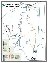
SKOK MEADOW<br />
SUMMERWOOD<br />
GIRDLED<br />
Big Creek<br />
Big Creek<br />
NORTH ENTRANCE<br />
Aylworth Creek<br />
CALLOW<br />
16<br />
<strong>Girdled</strong> <strong>Road</strong> <strong>Reservation</strong><br />
North Entrance:<br />
12898 <strong>Girdled</strong> <strong>Road</strong><br />
Concord Twp., Ohio 44077<br />
GPS Lon: 81° 10’ 39.850” W • Lat: 41° 40’ 4.641” N<br />
South Entrance:<br />
12899 Radcliffe <strong>Road</strong><br />
Concord Twp., Ohio 44077<br />
GPS Lon: 81° 10’ 28.605” W • Lat: 41° 38’ 29.009” N<br />
Skok Meadow Entrance:<br />
12415 Concord Hambden <strong>Road</strong> (Rt.608)<br />
Concord Twp., Ohio 44077<br />
GPS Lon: 81° 11’ 39.108” W • Lat: 41° 39’ 25.203” N<br />
•Hours: Sunrise to sunset.<br />
•Amenities: 932 acres. Picnic areas with grills. Picnic<br />
shelter (south). Drinking water (north), restrooms. Over<br />
seven miles of hiking trails. Playground (south). Fishing.<br />
Cross-country skiing. Ball/game fields (south).<br />
Pre-registration is required for most programs.<br />
<strong>Girdled</strong> <strong>Road</strong> <strong>Reservation</strong> was purchased<br />
by <strong>Lake</strong> <strong>Metroparks</strong> in 1965. It is named<br />
for the first road the early European<br />
settlers built from the Pennsylvania line<br />
to the new city of Cleveland in the early<br />
1800s. A small path was cut first. Settlers<br />
knew that a larger road was needed, so<br />
they “girdled” the trees along the path.<br />
(Girdling a tree means cutting through the<br />
bark around the entire tree. This cuts off<br />
the flow of nutrients so the tree dies. Once<br />
a tree dies, it is much easier to remove<br />
it and thus widen the road.) Today the<br />
remaining section of <strong>Girdled</strong> <strong>Road</strong> is the<br />
northern boundary of this park.<br />
photo by Tom Adair<br />
MEREDITH<br />
Legend<br />
Scenic Overlook<br />
Structures<br />
Parking Areas<br />
Ponds<br />
Streams<br />
Park Properties<br />
WINCHELL<br />
Trail Use<br />
Bike, Hike<br />
608<br />
Bike,Equestrian,Hike<br />
Hiking<br />
CONCORD-HAMBDEN<br />
Feet<br />
0 500 1,000 2,000 3,000<br />
Date: December 2010<br />
Source: <strong>Lake</strong> County GIS, <strong>Lake</strong> <strong>Metroparks</strong> GIS<br />
SOUTH ENTRANCE<br />
RADCLIFFE<br />
This map is intended for use as a reference. All boundaries<br />
and locations are approximate. The information depicted was<br />
obtained from various government and proprietary sources.<br />
This map is believed to be accurate as of the publication date,<br />
but no warranty or guarantee on any park is given or implied.<br />
17