Girdled Road Reservation - Lake Metroparks
Girdled Road Reservation - Lake Metroparks
Girdled Road Reservation - Lake Metroparks

Create successful ePaper yourself
Turn your PDF publications into a flip-book with our unique Google optimized e-Paper software.
GIRDLED ROAD<br />
reservation<br />
By Vince Urbanski, Chief of Park Planning<br />
Near the Painesville Township and Concord Township<br />
border, at a spot in the woods that very closely represents the<br />
geographic center of <strong>Lake</strong> County, Big Creek contributes its<br />
waters to one of the finest <strong>Lake</strong> Erie tributaries, the Grand River.<br />
Big Creek begins its flow to the Grand in Hambden Township<br />
along the agricultural-suburban interface of northern Geauga<br />
County. Over the next 15 or so miles on its way to the Grand,<br />
Big Creek merges with such streams as Aylworth Creek, East<br />
Creek, Jordan Creek and Kellogg Creek. Several other unnamed<br />
seasonal streams cascade over shale or glacial till beds before<br />
meeting up with this substantial tributary.<br />
Just as with its geographic location in <strong>Lake</strong> County, Big Creek<br />
lies at the heart of some of <strong>Lake</strong> <strong>Metroparks</strong>’ past and present<br />
highlights. The park district’s first park, Helen Hazen Wyman<br />
Park, is centered on the confluence of Kellogg Creek with Big<br />
Creek and Big Creek with the Grand River. At the opposite end<br />
of the spectrum, the Big Creek drainage is home to one of our<br />
most recently opened parks—Chair Factory Falls. Finally, Big<br />
Creek winds more than two miles through <strong>Lake</strong> <strong>Metroparks</strong>’<br />
largest park, 932-acre <strong>Girdled</strong> <strong>Road</strong> <strong>Reservation</strong>.<br />
<strong>Girdled</strong> <strong>Road</strong> <strong>Reservation</strong>, historically accessed from Radcliffe<br />
<strong>Road</strong> in the south and <strong>Girdled</strong> <strong>Road</strong> in the north, and now via<br />
Concord-Hambden <strong>Road</strong> (Rt. 608) at Skok Meadow, is one of<br />
the park district’s most biologically diverse properties. Covered<br />
by a mosaic of woodland, meadow and wetland, the park is<br />
home to a wide variety of plants and animals. This year alone,<br />
64 resident bird species, 38 butterflies, 18 mammals, 39<br />
dragonflies and damselflies, 19 reptiles and amphibians and<br />
countless plant species have been documented in the park.<br />
Among these are a number of rare or endangered species<br />
including yellow-bellied sapsuckers, cerulean warblers, bobolinks<br />
and a shrub called hobblebush.<br />
A view of Big Creek in spring from the<br />
overlook at <strong>Girdled</strong> <strong>Road</strong> <strong>Reservation</strong> North.<br />
15
<strong>Girdled</strong> <strong>Road</strong> <strong>Reservation</strong><br />
Big Creek has cut a deep gorge through the center of the<br />
park from south to north as have three sizable tributaries<br />
entering the main stream from the east. This geologic force has<br />
created a series of deeply incised stream valleys separated by<br />
peninsulas of dry uplands. This rollercoaster of topography has<br />
also necessitated the construction of a network of interesting<br />
trails ranging from easy, short and flat loops to strenuous, long,<br />
up-and-down stretches. In total, there are more than 7.5 miles of<br />
trails in the park including more than 1.5 miles added in 2010.<br />
There are very few, if any, other locations in <strong>Lake</strong> County where<br />
you can experience this quantity and quality of trails within a<br />
top-notch natural area.<br />
With all that it already has to offer, <strong>Girdled</strong> <strong>Road</strong> <strong>Reservation</strong><br />
is still evolving. This past summer, the park district completed<br />
the first phase of a planned multi-phase improvement to the<br />
western half of the park, known as Skok Meadow. This initial<br />
work involved the installation of a 20-car parking lot, a onemile<br />
mowed grass trail, and access to a stocked fishing pond.<br />
Concurrently, a 20-acre meadow restoration (see The Evolution<br />
of Skok Meadow on pages 18-19) is underway in the former<br />
pasture. Future phases being contemplated include typical park<br />
amenities like a restroom and picnic shelter, along with further<br />
expansion of the trail network with the ultimate goal of linking<br />
the trails east and west of Big Creek via a pedestrian bridge or<br />
bridges. In addition, two overlook decks are in the works and will<br />
offer commanding views of the Big Creek valley and the restored<br />
meadow.<br />
The Skok Meadow section of the park is also home to a<br />
restoration of one of <strong>Lake</strong> County’s earliest barns, the Hosea<br />
Brown Barn. Built by one of Concord Township’s first families,<br />
the barn harkens back to a time when the community’s uplands<br />
were dominated by agriculture and Big Creek powered a number<br />
of mills within its valley (see Hosea Brown’s Barn on pages<br />
20-21).<br />
<strong>Girdled</strong> <strong>Road</strong> <strong>Reservation</strong>’s 932-plus acres have been pieced<br />
together over the last 45 years in a patient pursuit of a vision<br />
established by <strong>Lake</strong> <strong>Metroparks</strong> and <strong>Lake</strong> County planners. At<br />
the same time, improvements to the park continue to evolve.<br />
Here today are the goals of balancing public access to the most<br />
interesting areas the park has to offer, while still protecting the<br />
fine natural resources described above. Stay tuned and join us<br />
in expecting great(er) things to come.<br />
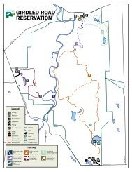
SKOK MEADOW<br />
SUMMERWOOD<br />
GIRDLED<br />
Big Creek<br />
Big Creek<br />
NORTH ENTRANCE<br />
Aylworth Creek<br />
CALLOW<br />
16<br />
<strong>Girdled</strong> <strong>Road</strong> <strong>Reservation</strong><br />
North Entrance:<br />
12898 <strong>Girdled</strong> <strong>Road</strong><br />
Concord Twp., Ohio 44077<br />
GPS Lon: 81° 10’ 39.850” W • Lat: 41° 40’ 4.641” N<br />
South Entrance:<br />
12899 Radcliffe <strong>Road</strong><br />
Concord Twp., Ohio 44077<br />
GPS Lon: 81° 10’ 28.605” W • Lat: 41° 38’ 29.009” N<br />
Skok Meadow Entrance:<br />
12415 Concord Hambden <strong>Road</strong> (Rt.608)<br />
Concord Twp., Ohio 44077<br />
GPS Lon: 81° 11’ 39.108” W • Lat: 41° 39’ 25.203” N<br />
•Hours: Sunrise to sunset.<br />
•Amenities: 932 acres. Picnic areas with grills. Picnic<br />
shelter (south). Drinking water (north), restrooms. Over<br />
seven miles of hiking trails. Playground (south). Fishing.<br />
Cross-country skiing. Ball/game fields (south).<br />
Pre-registration is required for most programs.<br />
<strong>Girdled</strong> <strong>Road</strong> <strong>Reservation</strong> was purchased<br />
by <strong>Lake</strong> <strong>Metroparks</strong> in 1965. It is named<br />
for the first road the early European<br />
settlers built from the Pennsylvania line<br />
to the new city of Cleveland in the early<br />
1800s. A small path was cut first. Settlers<br />
knew that a larger road was needed, so<br />
they “girdled” the trees along the path.<br />
(Girdling a tree means cutting through the<br />
bark around the entire tree. This cuts off<br />
the flow of nutrients so the tree dies. Once<br />
a tree dies, it is much easier to remove<br />
it and thus widen the road.) Today the<br />
remaining section of <strong>Girdled</strong> <strong>Road</strong> is the<br />
northern boundary of this park.<br />
photo by Tom Adair<br />
MEREDITH<br />
Legend<br />
Scenic Overlook<br />
Structures<br />
Parking Areas<br />
Ponds<br />
Streams<br />
Park Properties<br />
WINCHELL<br />
Trail Use<br />
Bike, Hike<br />
608<br />
Bike,Equestrian,Hike<br />
Hiking<br />
CONCORD-HAMBDEN<br />
Feet<br />
0 500 1,000 2,000 3,000<br />
Date: December 2010<br />
Source: <strong>Lake</strong> County GIS, <strong>Lake</strong> <strong>Metroparks</strong> GIS<br />
SOUTH ENTRANCE<br />
RADCLIFFE<br />
This map is intended for use as a reference. All boundaries<br />
and locations are approximate. The information depicted was<br />
obtained from various government and proprietary sources.<br />
This map is believed to be accurate as of the publication date,<br />
but no warranty or guarantee on any park is given or implied.<br />
17
the<br />
evolution<br />
of Skok Meadow<br />
filling drill<br />
with seed blends<br />
Article and photos by Tom Adair, Natural Resource Manager<br />
For much of the last century, the property<br />
now called Skok Meadow had been in agricultural<br />
production. This area, situated along <strong>Girdled</strong> <strong>Road</strong><br />
<strong>Reservation</strong>’s western boundary, was home to prized<br />
cattle and a large expanse of cool season grasses<br />
on which they would graze. Today, the site is <strong>Girdled</strong><br />
<strong>Road</strong> <strong>Reservation</strong>’s newest park entrance and home<br />
to a roughly 30-acre grassland complex perched just<br />
above the Big Creek Valley.<br />
Pasture lands all across Ohio are being left to revert<br />
back to old field areas as once larger farmsteads<br />
are sold off and broken into smaller parcels for<br />
development. If residential development pressure<br />
does not consume these lands, they can spend<br />
successive decades “growing up.” This form of<br />
vegetative succession can result in an increase in<br />
plant and animal biodiversity over time. Agricultural<br />
lands represent an important piece in the regional<br />
habitat puzzle. These areas are utilized by grassland<br />
specialists such as bobolinks, meadowlarks<br />
and numerous butterfly species. Land that is in<br />
active agricultural production can sometimes<br />
have a diminished value to wildlife as a result of<br />
interruptions by multiple hay cuttings that destroy<br />
nesting habitat. An intact and largely uninterrupted<br />
open meadow habitat is an increasingly important<br />
habitat type for these plant and wildlife populations.<br />
<strong>Lake</strong> <strong>Metroparks</strong> has decided to take an active<br />
approach to enhancing the habitat at Skok Meadow.<br />
Allowing the former pasture to revert back to<br />
meadow on its own would eventually result in a more<br />
diverse plant community, however this would be a<br />
relatively slow process. Our plan is to establish a mix<br />
of warm season grasses and forbs (flowering plants)<br />
on the site within a period of five to seven years, with<br />
periodic management.<br />
Beginning in the summer of 2010 and continuing<br />
into the fall, several herbicide applications were<br />
made to nearly 22 acres of the total 30-acre<br />
grassland complex. These applications of a low<br />
persistence herbicide were completed so that<br />
existing cool season weeds were eliminated from<br />
the site. The elimination of these existing plants set<br />
the stage by creating appropriate conditions for a<br />
seeding finished in November 2010.<br />
<strong>Lake</strong> <strong>Metroparks</strong> used herbicide rather than tillage<br />
practices so that we would not disturb the underlying<br />
seedbank, which could lead to greater competition<br />
for the young meadow seedlings that will begin to<br />
emerge in spring 2011. The practice also leaves the<br />
soil layer intact and reduces the potential for the<br />
erosion that often accompanies tillage practices. This<br />
was an important management consideration for<br />
a site directly adjacent to the Big Creek Valley and<br />
watershed.<br />
<strong>Lake</strong> <strong>Metroparks</strong> contracted with Ohio Prairie Nursery<br />
(Hiram, Ohio) to create two custom seed blends and<br />
carry out the planting of the seed. One seed blend<br />
was mixed to accommodate the dryer, upland areas<br />
and the other was more suited to the persistently<br />
wet areas of the meadow. Each blend contains a<br />
mixture of dozens of grasses and forbs that should<br />
result in a highly diverse meadow over time. The<br />
upland mix contained grasses like Indian Grass as<br />
well as a variety of forbs including Purple Coneflower<br />
and Black-eyed Susan. The wet areas will give rise<br />
to plants like Big Bluestem, Brown Fox Sedge, Ohio<br />
Spiderwort and Grey-headed Coneflower.<br />
A dormant season planting was completed in<br />
November 2010 by Ohio Prairie Nursery using a<br />
no-till seed drill over most of the area (areas that<br />
remained too wet at the time of seeding were planted<br />
by manually broadcasting the seed). The no-till<br />
method ensures that the seed is drilled down to the<br />
appropriate depth to spend the winter preparing<br />
itself for eventual spring germination and emergence.<br />
In addition to reducing soil erosion, no-till seeding<br />
conserves moisture already present in the seedbed<br />
and also requires less time and fuel than traditional<br />
tillage-based practices.<br />
herbicide<br />
Within the next few years the field will begin to show<br />
an emerging mosaic of the seeded grasses and<br />
forbs. In time, any gaps will begin to fill in as seeds<br />
drop from the established plants and the establishing<br />
plants begin to spread out. Throughout this period,<br />
<strong>Lake</strong> <strong>Metroparks</strong> staff will monitor the vegetative<br />
succession and manage any invasive or unwanted<br />
species that may be present. By the third year of<br />
the meadow establishment, fire will be applied as a<br />
management tool by burning the meadow and then<br />
continuing to burn on a three to five year rotational<br />
basis. Grasslands coevolved with disturbances like<br />
fire and many of the plant species are stimulated<br />
by periodic burns. In addition to promoting the<br />
desirable plant species, these controlled burns<br />
tend to discourage the growth and establishment of<br />
competing cool season weeds.<br />
The eventual progression from a field predominated<br />
by several cool season weed species to the<br />
establishment of a biologically diverse meadow<br />
habitat with dozens of representative grasses and<br />
flowering plants is a slow and unpredictable process<br />
if nature takes its own course. With a little planning<br />
and some human intervention, we can urge that<br />
progression along slightly. In the end, we arrive at<br />
a similar place, but taking an active role can allow<br />
more generations to witness the ecological benefits<br />
of these dynamic habitats—more birders witnessing<br />
their first spring migration, more children seeing their<br />
first Praying Mantis climbing a Goldenrod stalk and<br />
perhaps, more people willing to mimic these same<br />
habitats in their own backyards!<br />
no-till seed drill<br />
on tractor<br />
18<br />
19
Hosea Brown’s Barn<br />
By Andy Baker, Farmpark Administrator<br />
Buschmann Property 1958<br />
Around 1817, Revolutionary War veteran<br />
Oliver Brown, his wife Gracy and son Hosea moved to<br />
Concord, Ohio with Hosea’s young family. Within a year<br />
of arriving they framed up a house and barn, felling the<br />
tall straight poplars to hew into posts and beams. As<br />
they cleared the land, logs were hauled to a local water<br />
powered sawmill on nearby Big Creek to provide boards<br />
and planks. Their three-bay “English” style barn provided<br />
housing for grain, hay and livestock, serving the needs<br />
of the diversified style of farming that Oliver and Hosea<br />
transplanted from New England to the uplands of what<br />
would become <strong>Lake</strong> County.<br />
Hosea and Oliver laid out their 32’ by 42’ barn with the<br />
main door in the longer side wall. The central drive or<br />
threshing bay had large double doors on both ends and<br />
was floored with thick planks. The narrower east bay<br />
was set aside as a cow stable. At the south end of the<br />
east bay, a small door allowed entrance for humans<br />
and cattle. The 19’ deep west bay was used primarily<br />
for storing hay. Lofts above the main drive and the cow<br />
stables were used to store grain and hay. Two small<br />
framed buildings were built to house dried corn on the<br />
cob and threshed out grains.<br />
The Brown family continued to farm the property into the early 1900s.<br />
By the time Hosea’s grandson Fred died in 1926, parts of the property<br />
had begun a slow return to woodland. Hosea’s great grandson Elijah<br />
H. (then superintendent of Harding High School) was an ardent<br />
conservationist, a member of the Audubon society and a founder of<br />
the Blackbrook Audubon Club. He set aside 200 acres of land for the<br />
scouts and nature clubs to use for camping and nature study.<br />
After Elijah died in 1953 without any heirs, the property was purchased<br />
by Arthur and Gladys Buschmann who revived the farm as a stock farm<br />
to raise beef cattle. In 2002, after the death of Gladys Buschmann,<br />
<strong>Lake</strong> <strong>Metroparks</strong> purchased the property. By that time the barn, altered<br />
many times in its 185 years, needed attention.<br />
In 2007, <strong>Lake</strong> <strong>Metroparks</strong> hired a local timber framing specialist, Scott<br />
Carlson to evaluate the barn. Structural problems were evident and<br />
other unseen areas of rot lurked where decades of grass and grain<br />
seeds had encouraged burrowers or held in moisture to begin the<br />
rotting process. The sills, affected by proximity to the ground moisture<br />
had mostly disappeared. It was obvious that restoring the barn would<br />
require deconstruction and then reconstruction. Knowledge that<br />
this was the oldest documented barn in the county added incentive<br />
to the undertaking. In 2008, the construction firm, Union Industrial<br />
Construction, took down the old frame, repaired old beams, hewed new<br />
ones and erected the restored barn frame on its original foundation<br />
stones in its original location.<br />
2008<br />
Today the restored barn stands alone on the landscape<br />
in mute testimony to the story of those settlers who<br />
came to clear the land and settle <strong>Lake</strong> County. Over<br />
the years, the connection of the Brown family to the<br />
land evolved into a conservation ethic that helped<br />
launch the process that now preserves the land for<br />
future generations of <strong>Lake</strong> County residents. Today,<br />
<strong>Lake</strong> <strong>Metroparks</strong> is restoring the old fields to traditional<br />
grasses and providing access across the property with<br />
trails. Standing in the doorway of the newly restored<br />
barn, one can look to the east across the new meadow<br />
and get an appreciation for the view that Hosea Brown<br />
may have had almost 200 years ago.<br />
2010<br />
Five years after his father Oliver died, Hosea listed four<br />
horses, a team of oxen and seven milk cows on the<br />
1850 Census. He raised 35 tons of hay, 20 bushels of<br />
wheat and 55 bushels of oats and 100 bushels of corn.<br />
Other more temporary structures may have housed his<br />
25 other cattle, 25 sheep and four swine.<br />
GIRDLED ROAD<br />
Brown<br />
barn<br />
Brown<br />
Property<br />
1850<br />
2009 disassembly<br />
A few old barns can still be picked out on the <strong>Lake</strong> County<br />
landscape. Many are now surrounded by houses or shopping<br />
centers. With their primary task accomplished (that of housing<br />
the crops and livestock of early Western Reserve farmers),<br />
they were gradually abandoned. Every year a few more<br />
succumb to rotting sills or the moisture eating away beneath<br />
a leaky roof or are torn down to make way for progress.<br />
1915. Much of the Brown land is now part of<br />
<strong>Lake</strong> <strong>Metroparks</strong> <strong>Girdled</strong> <strong>Road</strong> <strong>Reservation</strong>.<br />
20 photo by Tom Adair<br />
21