Lewisport, Kentucky - Kentucky Cabinet for Economic Development
Lewisport, Kentucky - Kentucky Cabinet for Economic Development Lewisport, Kentucky - Kentucky Cabinet for Economic Development
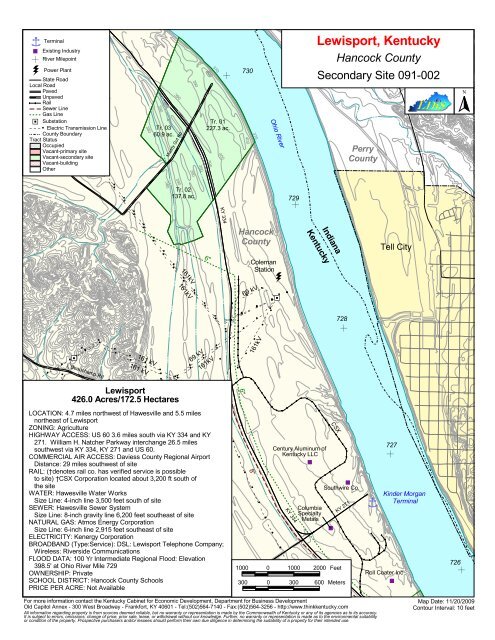
úúú úúú ú úúú úúú úúú úúú úúúúúú úúúúúú úúúúúú úúú úúú úúú úúú úúú úúú úúú úúú úúú úúú úúú úú úúú úúú úúú úúú úúú úúú úúú úúú úúú úúú úúú úúú úúú úúú úúú úúú úúú úúú ' ' ' Î Terminal % Existing Industry ÿ N River Milepoint Power Plant State Road Local Road Paved Unpaved Rail Sewer Line Gas Line úúú' %[ Substation Electric Transmission Line County Boundary Tract Status Occupied Vacant-primary site Vacant-secondary site Vacant-building Other ' ' ' ' ' ' ' ' ' ' ' ' ' ' ' ' ' ' ' ' ' ' ' ' ' ' ' ' ' ' ' ' ' ' ' ' ' ' ' 380 390 380 Tr. 03 60.9 ac. 390 Muddy Gut Rd 390 390 390 400 N Tr. 01 227.3 ac. 390 370 400 730 400 370 Ohio River Lewisport, Kentucky Hancock County Secondary Site 091-002 Perry County N 380 390 Tr. 02 137.8 ac. 729 N KY 334 úúú úúú úúú úúú úúú úúú úúú úúú úú úú úúú úú úú úúú úúú úúú úúú úúú úúú úúú úúú úú úú úúú úúú úúú úúú úúú úúú úúú úúú úú ' ' ú ú ' ' ' ' úúú úúú úúú ' ' ' ' ' ' ' ' ' ' ' ' ' ' ' ' ' ' ' ' ' ' ' ' ' ' ' ' ' 'ú úúú úúú ú úúú úúú úúú úúú ' %[ ' ' ' ' Beauchamp Rd úúú úúú úúú úúú úúú úúú úúú úúú úúú úúú úúú úúú úúú úúú CSX 161kV 161kV ' ' ' ' ' ' ' ' ' ' ' ' ' ' ' 161 kV 161 kV Lewisport 426.0 Acres/172.5 Hectares 6" ú úúú úúú úúú úú 69 kV ' ' ' ' úúú úúú úúú úú ' ' úúú ú ' ' úúú úúú úúú úú ' ' ' ' ' ' ' ' ú úúú úúú úúú úúú úú ú úúú úúú úúú úúú úúú úúú ' ' ' ' ' ' ' 161kV ú úú úúú úúú úúú úúú úúúúúú úúú ú ' ' ' LOCATION: 4.7 miles northwest of Hawesville and 5.5 miles northeast of Lewisport ZONING: Agriculture HIGHWAY ACCESS: US 60 3.6 miles south via KY 334 and KY 271. William H. Natcher Parkway interchange 26.5 miles southwest via KY 334, KY 271 and US 60. COMMERCIAL AIR ACCESS: Daviess County Regional Airport Distance: 29 miles southwest of site RAIL: (†denotes rail co. has verified service is possible to site) †CSX Corporation located about 3,200 ft south of the site WATER: Hawesville Water Works Size Line: 4-inch line 3,500 feet south of site SEWER: Hawesville Sewer System Size Line: 8-inch gravity line 6,200 feet southeast of site NATURAL GAS: Atmos Energy Corporation Size Line: 6-inch line 2,915 feet southeast of site ELECTRICITY: Kenergy Corporation BROADBAND (Type:Service): DSL: Lewisport Telephone Company; Wireless: Riverside Communications FLOOD DATA: 100 Yr Intermediate Regional Flood: Elevation 398.5' at Ohio River Mile 729 OWNERSHIP: Private SCHOOL DISTRICT: Hancock County Schools PRICE PER ACRE: Not Available ' Hancock County ' ' ' ' ' úúú úúú úúú úúú úúú úúú úúú úúú 6" ' ' ' ' ' ' ' ' ' 161kV 8" Coleman Station 69 kV 161kV %[ ' ' ÿ Century Aluminum of Kentucky LLC % KY 334 úúú úúú úúú úúú úúú úú ' ' ' ' Indiana Kentucky Columbia Specialty Metals N CSX 1000 0 1000 2000 Feet % Southwire Co. For more information contact the Kentucky Cabinet for Economic Development, Department for Business Development Old Capitol Annex - 300 West Broadway - Frankfort, KY 40601 - Tel:(502)564-7140 - Fax:(502)564-3256 - http://www.thinkkentucky.com All information regarding property is from sources deemed reliable, but no warranty or representation is made by the Commonwealth of Kentucky or any of its agencies as to its accuracy. It is subject to errors, omissions, change of price, prior sale, lease, or withdrawal without our knowledge. Further, no warranty or representation is made as to the environmental suitability or condition of the property. Prospective purchasers and/or lessees should perform their own due diligence in determining the suitability of a property for their intended use. % 728 KY 271 300 0 300 600 Meters Î Tell City 727 N Kinder Morgan Terminal Roll Coater Inc % 726 N Map Date: 11/20/2009 Contour Interval: 10 feet
úúú úúú ú<br />
úúú úúú<br />
úúú úúú úúúúúú úúúúúú úúúúúú úúú úúú úúú úúú úúú úúú úúú úúú úúú úúú úúú<br />
úú úúú úúú úúú úúú úúú úúú úúú úúú úúú úúú úúú úúú úúú úúú úúú úúú úúú úúú<br />
' '<br />
'<br />
Î Terminal<br />
% Existing Industry<br />
ÿ<br />
N<br />
River Milepoint<br />
Power Plant<br />
State Road<br />
Local Road<br />
Paved<br />
Unpaved<br />
Rail<br />
Sewer Line<br />
Gas Line<br />
úúú' %[ Substation<br />
Electric Transmission Line<br />
County Boundary<br />
Tract Status<br />
Occupied<br />
Vacant-primary site<br />
Vacant-secondary site<br />
Vacant-building<br />
Other<br />
' ' ' ' ' ' ' ' ' ' ' ' ' ' ' ' ' ' ' '<br />
' ' ' ' ' ' ' ' ' ' ' ' ' ' ' ' ' ' '<br />
380<br />
390<br />
380<br />
Tr. 03<br />
60.9 ac.<br />
390<br />
Muddy Gut Rd<br />
390<br />
390<br />
390<br />
400<br />
N<br />
Tr. 01<br />
227.3 ac.<br />
390<br />
370<br />
400<br />
730<br />
400<br />
370<br />
Ohio River<br />
<strong>Lewisport</strong>, <strong>Kentucky</strong><br />
Hancock County<br />
Secondary Site 091-002<br />
Perry<br />
County<br />
N<br />
380<br />
390<br />
Tr. 02<br />
137.8 ac.<br />
729<br />
N<br />
KY 334<br />
úúú úúú úúú úúú úúú úúú úúú úúú úú<br />
úú úúú úú<br />
úú úúú úúú úúú úúú úúú úúú úúú úúú úú<br />
úú úúú úúú úúú úúú úúú úúú úúú úúú úú<br />
'<br />
'<br />
ú<br />
ú<br />
'<br />
'<br />
' '<br />
úúú úúú úúú<br />
' ' '<br />
' '<br />
' ' ' ' ' ' ' ' '<br />
' ' ' ' ' ' ' ' '<br />
' ' ' ' ' ' 'ú úúú úúú ú<br />
úúú úúú<br />
úúú úúú<br />
'<br />
%[<br />
' '<br />
' '<br />
Beauchamp Rd<br />
úúú úúú úúú úúú úúú úúú úúú<br />
úúú úúú úúú úúú úúú úúú úúú<br />
CSX<br />
161kV<br />
161kV<br />
' ' ' ' ' ' ' '<br />
' ' ' ' ' ' '<br />
161 kV<br />
161 kV<br />
<strong>Lewisport</strong><br />
426.0 Acres/172.5 Hectares<br />
6"<br />
ú úúú úúú úúú úú<br />
69 kV<br />
' ' ' '<br />
úúú úúú úúú úú<br />
' '<br />
úúú ú<br />
' '<br />
úúú úúú úúú úú<br />
' ' ' '<br />
' ' ' '<br />
ú úúú úúú úúú úúú úú<br />
ú úúú úúú úúú úúú úúú úúú<br />
' ' ' ' ' ' '<br />
161kV<br />
ú<br />
úú<br />
úúú úúú úúú úúú úúúúúú úúú ú<br />
'<br />
' '<br />
LOCATION: 4.7 miles northwest of Hawesville and 5.5 miles<br />
northeast of <strong>Lewisport</strong><br />
ZONING: Agriculture<br />
HIGHWAY ACCESS: US 60 3.6 miles south via KY 334 and KY<br />
271. William H. Natcher Parkway interchange 26.5 miles<br />
southwest via KY 334, KY 271 and US 60.<br />
COMMERCIAL AIR ACCESS: Daviess County Regional Airport<br />
Distance: 29 miles southwest of site<br />
RAIL: (†denotes rail co. has verified service is possible<br />
to site) †CSX Corporation located about 3,200 ft south of<br />
the site<br />
WATER: Hawesville Water Works<br />
Size Line: 4-inch line 3,500 feet south of site<br />
SEWER: Hawesville Sewer System<br />
Size Line: 8-inch gravity line 6,200 feet southeast of site<br />
NATURAL GAS: Atmos Energy Corporation<br />
Size Line: 6-inch line 2,915 feet southeast of site<br />
ELECTRICITY: Kenergy Corporation<br />
BROADBAND (Type:Service): DSL: <strong>Lewisport</strong> Telephone Company;<br />
Wireless: Riverside Communications<br />
FLOOD DATA: 100 Yr Intermediate Regional Flood: Elevation<br />
398.5' at Ohio River Mile 729<br />
OWNERSHIP: Private<br />
SCHOOL DISTRICT: Hancock County Schools<br />
PRICE PER ACRE: Not Available<br />
'<br />
Hancock<br />
County<br />
' ' ' ' '<br />
úúú úúú úúú úúú úúú úúú úúú úúú<br />
6"<br />
' ' ' ' ' ' ' ' '<br />
161kV<br />
8"<br />
Coleman<br />
Station<br />
69 kV<br />
161kV<br />
%[<br />
'<br />
'<br />
ÿ<br />
Century Aluminum of<br />
<strong>Kentucky</strong> LLC<br />
%<br />
KY 334<br />
úúú úúú úúú úúú úúú úú<br />
' ' ' '<br />
Indiana<br />
<strong>Kentucky</strong><br />
Columbia<br />
Specialty<br />
Metals<br />
N<br />
CSX<br />
1000 0 1000 2000 Feet<br />
%<br />
Southwire Co.<br />
For more in<strong>for</strong>mation contact the <strong>Kentucky</strong> <strong>Cabinet</strong> <strong>for</strong> <strong>Economic</strong> <strong>Development</strong>, Department <strong>for</strong> Business <strong>Development</strong><br />
Old Capitol Annex - 300 West Broadway - Frank<strong>for</strong>t, KY 40601 - Tel:(502)564-7140 - Fax:(502)564-3256 - http://www.thinkkentucky.com<br />
All in<strong>for</strong>mation regarding property is from sources deemed reliable, but no warranty or representation is made by the Commonwealth of <strong>Kentucky</strong> or any of its agencies as to its accuracy.<br />
It is subject to errors, omissions, change of price, prior sale, lease, or withdrawal without our knowledge. Further, no warranty or representation is made as to the environmental suitability<br />
or condition of the property. Prospective purchasers and/or lessees should per<strong>for</strong>m their own due diligence in determining the suitability of a property <strong>for</strong> their intended use.<br />
%<br />
728<br />
KY 271<br />
300 0 300 600 Meters<br />
Î<br />
Tell City<br />
727<br />
N<br />
Kinder Morgan<br />
Terminal<br />
Roll Coater Inc<br />
%<br />
726<br />
N<br />
Map Date: 11/20/2009<br />
Contour Interval: 10 feet
Perry<br />
e þ Fire Station Local Airport<br />
County<br />
Î Terminal<br />
Lock and Dam<br />
Hancock<br />
Troy<br />
$T Point of Interest<br />
County<br />
Secondary<br />
N<br />
US Highway<br />
State Road<br />
Airport<br />
Site 091-002<br />
Local Road<br />
426.0 Acres<br />
Paved Spencer<br />
Unpaved<br />
Rail<br />
County<br />
Municipal Boundary<br />
Secondary<br />
County Boundary<br />
Site 091-003<br />
Tract Status<br />
1,108.7 Acres<br />
Tell City<br />
Occupied<br />
Vacant-primary site<br />
Vacant-secondary site<br />
Vacant-building<br />
Other<br />
e Adair<br />
#<br />
Kinder<br />
Morgan<br />
Secondary<br />
Î<br />
Terminal<br />
#<br />
þ Site 091-005<br />
889.1 Acres<br />
(/ 60 Petri<br />
#<br />
<strong>Lewisport</strong><br />
Secondary<br />
Cannelton<br />
Waitman<br />
Site 091-001<br />
Site 091-006<br />
#<br />
$T<br />
(/ 60 141.8 Acres<br />
28.0 Acres<br />
Cannelton<br />
Hancock<br />
Hancock County<br />
þ<br />
Lock & Dam<br />
County<br />
<strong>Development</strong> Center<br />
Daviess<br />
Skillman<br />
#<br />
County<br />
Hawesville<br />
(/ 60 Secondary<br />
Site 091-004<br />
1,020.0 Acres<br />
# Yelvington<br />
#S Ohio<br />
Indianapolis #<br />
Sunny #S Cincinnati<br />
Illinois Corner<br />
Indiana<br />
Huntington<br />
#S<br />
Chambers<br />
Evansville #S Louisville<br />
#S<br />
#<br />
#S ÊÚ<br />
Lexington West<br />
Virginia<br />
Gatewood #<br />
<strong>Lewisport</strong><br />
& Hawesville<br />
1 0 1 Miles<br />
Missouri<br />
Virginia<br />
1 0 1 Kilometers #<br />
# Nashville<br />
#S<br />
Knoxville<br />
Scythia<br />
Tennessee<br />
#S<br />
Breckinridge<br />
Map Date: 11/20/2009<br />
KY 334<br />
CSX<br />
KY 662<br />
IN245<br />
IN66<br />
KY 657<br />
IN70<br />
Ohio River<br />
#<br />
For more in<strong>for</strong>mation contact the <strong>Kentucky</strong> <strong>Cabinet</strong> <strong>for</strong> <strong>Economic</strong> <strong>Development</strong>, Department <strong>for</strong> Business <strong>Development</strong><br />
Old Capitol Annex - 300 West Broadway - Frank<strong>for</strong>t, KY 40601 - Tel:(502)564-7140 - Fax:(502)564-3256 - http://www.thinkkentucky.com<br />
IN66<br />
KY 1957<br />
KY 1389<br />
Indiana<br />
<strong>Kentucky</strong><br />
All in<strong>for</strong>mation regarding property is from sources deemed reliable, but no warranty or representation is made by the Commonwealth of <strong>Kentucky</strong> or any of its agencies as to its accuracy.<br />
It is subject to errors, omissions, change of price, prior sale, lease, or withdrawal without our knowledge. Further, no warranty or representation is made as to the environmental suitability<br />
or condition of the property. Prospective purchasers and/or lessees should per<strong>for</strong>m their own due diligence in determining the suitability of a property <strong>for</strong> their intended use.<br />
KY 271<br />
KY 334<br />
KY 1605<br />
IN545<br />
KY 271<br />
CSX<br />
CSX<br />
KY 2181<br />
KY 334<br />
Ohio River<br />
KY 69<br />
IN237<br />
KY 1265<br />
IN 37<br />
Hawesville & <strong>Lewisport</strong><br />
Hancock County, <strong>Kentucky</strong><br />
CSX<br />
IN66<br />
KY 1406<br />
IN66<br />
IN166


