

Farsley Village Statement
Farsley Village Statement
Farsley Village Statement

You also want an ePaper? Increase the reach of your titles
YUMPU automatically turns print PDFs into web optimized ePapers that Google loves.
<strong>Farsley</strong> Design <strong>Statement</strong>_Layout 1 31/08/2010 10:29 Page 1<br />
<strong>Farsley</strong><strong>Village</strong><br />
Design<br />
<strong>Statement</strong>
<strong>Farsley</strong> Design <strong>Statement</strong>_Layout 1 31/08/2010 10:29 Page 2
<strong>Farsley</strong> Design <strong>Statement</strong>_Layout 1 31/08/2010 10:56 Page 3<br />
<strong>Farsley</strong> <strong>Village</strong> Design <strong>Statement</strong><br />
Contents<br />
INTRODUCTION 4<br />
The function of this document<br />
SETTING AND LOCATION 5<br />
The location and boundaries<br />
of the village<br />
VILLAGE EVOLUTION AND 6<br />
GEOGRAPHICAL DEVELOPMENT<br />
A brief description and history of <strong>Farsley</strong><br />
CHARACTER AREAS 7-12<br />
The main areas of historic and<br />
special interest<br />
BUILT FORM 13-21<br />
Materials and construction<br />
SPATIAL ANALYSIS 22-28<br />
Transport Corridors and Pedestrian Routes,<br />
Nodes and Gateways, Views,<br />
and Open Spaces<br />
APPENDICES 29-49<br />
3
<strong>Farsley</strong> Design <strong>Statement</strong>.qxp 23/11/10 08:28 Page 4<br />
<strong>Farsley</strong> <strong>Village</strong> Design <strong>Statement</strong><br />
Introduction<br />
The FARSLEY VILLAGE DESIGN STATEMENT is<br />
an advisory document produced on behalf of the<br />
village by members of the village community,<br />
suggesting how development should be carried<br />
out in harmony with the village and its setting.<br />
Consultation has been carried out with officers<br />
and Members of Leeds City Council and with<br />
English Heritage in the formulation of the<br />
document.<br />
Residents of <strong>Farsley</strong> have been given the<br />
opportunity to contribute by means of a<br />
questionnaire and through workshops and<br />
public meetings (some extracts shown as<br />
quotations). It is anticipated that a working<br />
group made up of local residents may be<br />
established in order to assist in the monitoring<br />
of developments within the village.<br />
The <strong>Village</strong> Design <strong>Statement</strong> has been adopted<br />
as informal planning guidance by Leeds City<br />
Council Planning Board following appropriate<br />
consultation. The purpose of the <strong>Village</strong> Design<br />
<strong>Statement</strong> is to:<br />
● enable the community to analyse and define<br />
the value of their local environment<br />
● act as a tool for assessing the local character<br />
of the area<br />
● assist the City Council in steering future<br />
development to respond to and respect<br />
that character<br />
● guide smaller changes ("permitted<br />
development")<br />
● provide direction for local environmental<br />
improvements and support community<br />
initiatives<br />
● be used by the Council as a material<br />
consideration in the assessment of planning<br />
applications and all other planning matters.<br />
View from the Half Mile Lane/Coal Hill Lane junction<br />
showing the mix of mill cottages, pre-war semi-detached<br />
houses, and the modern Broom Mills apartments<br />
4<br />
A quiet walk along Priesthorpe Lane<br />
The study area for the <strong>Village</strong> Design <strong>Statement</strong><br />
was determined through consultation with key<br />
stakeholders within the area and with regard to<br />
a number of current and historic boundaries.<br />
These include the pre 1936 <strong>Farsley</strong> Urban<br />
District Council, the pre 1974 Pudsey Borough<br />
Ward of <strong>Farsley</strong>, the current Leeds City Council<br />
ward boundary of Calverley & <strong>Farsley</strong> and the<br />
Parish boundary. The aim was to include what<br />
could be classed as the historic area of <strong>Farsley</strong>,<br />
while also including those other areas which<br />
would naturally look to <strong>Farsley</strong> as their district<br />
centre. The boundary map (see Fig 1) is based<br />
on Ordnance Survey information as at January<br />
2006, which does not yet include<br />
developments on the Broom Mills and Beck<br />
Bottom Mills sites, the land to the north of<br />
Hainsworths Mill, or other more recent changes.
<strong>Farsley</strong> Design <strong>Statement</strong>.qxp 23/11/10 08:28 Page 5<br />
<strong>Farsley</strong> <strong>Village</strong> Design <strong>Statement</strong><br />
Setting & Location<br />
<strong>Farsley</strong> is located approximately half way<br />
between Leeds and Bradford on the south<br />
side of the River Aire valley. The Pudsey<br />
boundary abuts the southern edge of <strong>Farsley</strong><br />
along the Ring Road (Stanningley By-pass).<br />
In the early nineteenth century, <strong>Farsley</strong><br />
was a relatively small village, with Rodley to<br />
the north, Stanningley to the south and<br />
Calverley to the west. Due to the<br />
expansion of <strong>Farsley</strong> in the late nineteenth<br />
century and early twentieth century, the<br />
boundaries between the settlements are<br />
now less distinct . However, to the northeast<br />
and west the rural origins are still<br />
evident, providing an important green<br />
setting to the village.<br />
The core of the historic village is situated<br />
around Town Street and Old Road on the<br />
south side of the Aire valley, which runs at<br />
a relatively steep gradient towards the<br />
valley bottom. As a result <strong>Farsley</strong> is very<br />
prominent on the hillside when viewed<br />
from the north and east.<br />
Study Area Boundary<br />
including original Conservation Area (blue) and<br />
extension recommended by the Working Group (red)<br />
Fig.1<br />
5
<strong>Farsley</strong> Design <strong>Statement</strong>_Layout 1 31/08/2010 10:30 Page 6<br />
<strong>Farsley</strong> <strong>Village</strong> Design <strong>Statement</strong><br />
<strong>Village</strong> Evolution and<br />
Geographical<br />
Development<br />
The <strong>Farsley</strong> <strong>Village</strong> Design <strong>Statement</strong> is intended<br />
to ensure that any future developments and<br />
planning decisions should take into account the<br />
relevance of the historic development of the<br />
village and understand how it has evolved.<br />
Although probably in existence by the 13th<br />
century, it was the industrial revolution of the<br />
late 18th and the 19th century that set a<br />
framework for the layout of the village of<br />
<strong>Farsley</strong>. The several textile mills along with<br />
supporting industries were instrumental in<br />
establishing the location and materials used not<br />
only for these buildings, but also for the<br />
workers’ houses, schools, churches and chapels.<br />
The present large village originally evolved from<br />
a series of smaller settlements in the early<br />
nineteenth century. As the village developed,<br />
the new development followed the<br />
established highway network.<br />
The first half of the twentieth century saw the<br />
growth of terraced housing and probably the<br />
most notable development in the village was<br />
the start of the housing in the Farfield area to<br />
the west of Town Street/Old Road.<br />
<strong>Farsley</strong> experienced rapid expansion in the<br />
second half of the twentieth century. The<br />
area had acquired the basic structure evident<br />
today with the expansion of residential estates<br />
to the east and west of Town Street and Old<br />
Road and north of Bagley Lane. Other<br />
significant developments were the<br />
introduction of the Ring Road around the<br />
southern and western edges of the study area<br />
and the mixed development of the Dawsons<br />
Corner area. Also by this time a Railway<br />
station for the Bradford to London line had<br />
been introduced at “New Pudsey Station”.<br />
It is this evolutionary development that has<br />
established the different character areas within<br />
the study area. These are explored in detail in<br />
the following section.<br />
The entrance to Hainsworths Mill<br />
6
<strong>Farsley</strong> Design <strong>Statement</strong>_Layout 1 31/08/2010 10:30 Page 7<br />
<strong>Farsley</strong> <strong>Village</strong> Design <strong>Statement</strong><br />
Character Areas<br />
5<br />
2<br />
1<br />
7<br />
6<br />
4<br />
8<br />
3<br />
Fig.2<br />
1. Historic Core<br />
2. Priesthorpe<br />
3. Stanningley<br />
4. Farfield<br />
“ ”<br />
The friendly<br />
atmosphere<br />
5. Wadlands/Beech Lees<br />
6. Springbank/Kirklees<br />
7. Beck Bottom<br />
8. Newlands/Parkside<br />
7
<strong>Farsley</strong> Design <strong>Statement</strong>_Layout 1 31/08/2010 10:30 Page 8<br />
<strong>Farsley</strong> <strong>Village</strong> Design <strong>Statement</strong><br />
Character Areas<br />
Within the study area it is possible to identify eight<br />
physically separate character areas. The character<br />
of these areas relates to use of the land, form of<br />
the buildings, spaces between the buildings, and<br />
level of activity within an area. The character areas<br />
are as follows and are identified on Figure 2:<br />
1. Historic Core<br />
(including the Conservation Area)<br />
2. Priesthorpe<br />
3. Stanningley<br />
4. Farfield<br />
5. Wadlands/Beech Lees<br />
6. Springbank/Kirklees<br />
7. Beck Bottom<br />
8. Newlands/Parkside<br />
A description of each area together with the<br />
relevant FVDS recommendations is provided in the<br />
following paragraphs:<br />
1. Historic Core<br />
This area is the historic centre of <strong>Farsley</strong> and<br />
remains the heart of the village, whilst its mix of<br />
activities continues to reflect a traditional village<br />
atmosphere. Associated with the variety of<br />
uses is the level of pedestrian activity which is<br />
particularly apparent at lunch time during the<br />
week and all day on a Saturday.<br />
The buildings are predominantly of a terraced<br />
form fronting onto the highway, either two,<br />
three or four storeys in height.<br />
In conjunction with the sloping site, this creates<br />
a varied streetscape. There are some examples<br />
of detached buildings set in generous grounds,<br />
such as the Liberal Club, and <strong>Farsley</strong> Working<br />
Men’s Club, but these are not common within<br />
the area.<br />
Cobbles at the entrance to Back Lane<br />
maintaining a link with <strong>Farsley</strong>’s heritage while<br />
providing a practical road surface.<br />
8
<strong>Farsley</strong> Design <strong>Statement</strong>.qxp 23/11/10 08:29 Page 9<br />
<strong>Farsley</strong> <strong>Village</strong> Design <strong>Statement</strong><br />
The Conservation Area<br />
The <strong>Farsley</strong> Conservation Area was originally<br />
designated in July 1989 and the boundary is<br />
shown in Figure 1.<br />
The buildings and spaces within the<br />
Conservation Area vary greatly: areas of<br />
terraced housing and streets either side of<br />
Town Street and Old Road; the industrial mill<br />
complexes and small workshops; workers’<br />
terraced housing ; and the grander buildings<br />
along New Street that overlook the open<br />
space of Westroyd Park.<br />
One of the recommendations is to enlarge the<br />
Conservation Area boundary to encompass<br />
the whole of the Historic Core, which is<br />
aligned generally in a north/south direction as<br />
shown in Figure 1. The proposal for an<br />
enlarged Conservation Area should be<br />
considered in any future review of the<br />
Conservation Area boundary.<br />
“<br />
Friendly village feel,<br />
good location, good<br />
local amenities, its<br />
still got a bit of<br />
character. We don’t<br />
want it spoiling with<br />
modern buildings in<br />
the centre<br />
”<br />
RECOMMENDATIONS<br />
1. <strong>Farsley</strong> Conservation Area should be extended to include those parts of the Historic<br />
Core not currently incorporated (Figure 1)<br />
2. Development within or adjacent to <strong>Farsley</strong> Conservation Area should preserve and<br />
enhance its protected character. Careful regard needs to be given to the following:<br />
I. The demolition of historic village buildings which make a positive contribution to the<br />
character of the Conservation Area should be resisted.<br />
II.<br />
III.<br />
IV.<br />
Consideration should be given in future reviews or appraisal of <strong>Farsley</strong> Conservation<br />
Area to extend the boundary to those parts of the Historic Core not currently<br />
incorporated (Figure 1).<br />
New development must respect the scale, height, massing materials and significant<br />
design details of the buildings in the immediate surroundings.<br />
Natural stone should normally be used for external and boundary walls.<br />
V. Blue slate or Yorkshire stone should normally be used for roofing material.<br />
VI.<br />
Windows and doors should be of a design and materials that reflect the traditional<br />
styles within the Conservation Area.<br />
UDPR (2006) Policies GP5, N18-22, BC7<br />
Neighbourhoods for Living Supplementary Planning Guidance<br />
PPS1: Planning and Sustainable Development<br />
PPS5: Planning for the Historic Environment<br />
9
<strong>Farsley</strong> Design <strong>Statement</strong>_Layout 1 31/08/2010 10:30 Page 10<br />
<strong>Farsley</strong> <strong>Village</strong> Design <strong>Statement</strong><br />
2. Priesthorpe<br />
Priesthorpe is predominantly an area of open<br />
ground used for agricultural purposes, subdivided<br />
by hedgerows or stone walls. There are<br />
pockets of development in the area in the form<br />
of farm complexes and associated workers’<br />
cottages. There are also large villas such as<br />
Springwood Hall.<br />
This area has a distinctive semi-rural character,<br />
with open fields and rough dirt tracks, much of<br />
which is protected by Green Belt designation.<br />
The openness of the area is complemented by<br />
the sounds of wildlife but the noise of the outer<br />
Ring Road does detract from this.<br />
View from Priesthorpe across valley<br />
towards Rawdon/Cookridge<br />
3. Stanningley<br />
This area is characterised by a mix of uses and<br />
the activity associated with the vehicular traffic<br />
along the Leeds/Bradford Road, with residential<br />
and industrial/office buildings in close proximity.<br />
The area suffers from heavy vehicle flows which<br />
generate a significant noise level throughout the<br />
day. Substantial green areas and the large<br />
Owlcotes retail park also lie within this area.<br />
The form of the residential buildings is similar to<br />
that within the historic core, predominantly with<br />
parallel two storey terraces set onto the back of<br />
the pavement.<br />
Stanningley Railway Viaduct<br />
4. Farfield<br />
Development started here during the interwar<br />
period of the 1930s and was completed post<br />
1945. It represents the first example of a new<br />
style of estate development in the area, with<br />
semi-detached houses with front and rear<br />
gardens.<br />
It has distinct character due to the brick and<br />
render materials of construction, which are not<br />
the traditional materials of the area. Important<br />
features are the trees that line the pavements<br />
along some roads, for example South Drive.<br />
10<br />
South Drive
<strong>Farsley</strong> Design <strong>Statement</strong>_Layout 1 31/08/2010 10:30 Page 11<br />
<strong>Farsley</strong> <strong>Village</strong> Design <strong>Statement</strong><br />
5. Wadlands/Beech Lees<br />
This is a residential area of the second half of the<br />
twentieth century characterised by estate style<br />
road layouts with detached, semi-detached and<br />
bungalow houses set back from the highway with<br />
front and rear gardens.<br />
The area has a suburban feel with little industrial<br />
activity.<br />
6. Springbank/Kirklees<br />
This is again a residential area of the second half of<br />
the twentieth century, with much of it similar in<br />
character to the much smaller Wadlands/Beech<br />
Lees, but separated from it by part of the historic<br />
core. The original early 1960’s Springbank estate<br />
has been substantially increased in size by<br />
successive developments.<br />
Houses in the Wadlands area<br />
The detached and semi-detached houses of the<br />
Kirklees estate, situated on a sloping site to the<br />
north of Bagley Lane, are built of a light coloured<br />
brick not sourced from the local area.<br />
7. Beck Bottom<br />
This is characterised by the valley of open space<br />
and public footpaths of Beck Bottom, and by the<br />
former mill complexes which dominated the<br />
landscape. The open space that remains creates<br />
a semi-rural character and the sound of wildlife is<br />
prominent. The area has recently suffered from<br />
the loss of some of the working mills which have<br />
now been redeveloped for housing.<br />
Part of the Kirklees development.<br />
The high-density Broom Mills development with<br />
its dominant buildings is distinctly different in style<br />
to this area, and also to the single storey and two<br />
storey houses of the adjacent Springbank estate<br />
upon which it impacts.<br />
The area of Bagley benefits from a variety of<br />
buildings which contribute to its important<br />
character. Perhaps the most important being<br />
Springfield Mill, which has retained many parts of<br />
the historic mill and is currently used as a<br />
commercial and industrial complex. Surrounding<br />
the mill are detached farm buildings and weavers<br />
cottages together with terraced properties.<br />
Broom Mill Apartments<br />
11
<strong>Farsley</strong> Design <strong>Statement</strong>_Layout 1 31/08/2010 10:30 Page 12<br />
<strong>Farsley</strong> <strong>Village</strong> Design <strong>Statement</strong><br />
8. Newlands/Parkside<br />
High density development at Newlands.<br />
This is a typical modern estate style development<br />
similar in layout to the Wadlands area. The houses<br />
vary from detached and semi-detached properties<br />
at Parkside to town houses and apartment blocks.<br />
Some houses have front and rear gardens but<br />
some have no front boundary walls to define the<br />
garden area.<br />
Although on the site of original industrial buildings,<br />
the area has a suburban feel with little current<br />
industrial activity.<br />
RECOMMENDATIONS<br />
All new development within <strong>Farsley</strong> should be designed so as to relate to its location, paying<br />
particular attention to the following considerations:<br />
i. Due account should be made to the ‘Character Area’ assessment in determining<br />
any planning application for development in the village.<br />
ii.<br />
New and extended buildings should be in harmony with the predominant character<br />
of that part of the village and respect the scale, style and detailed design of other<br />
buildings in the immediate vicinity to avoid incongruous built forms and styles.<br />
UDPR (2006) Policies GP5, N13<br />
Neighbourhoods for Living Supplementary Planning Guidance<br />
PPS1: Planning and Sustainable Development<br />
12
<strong>Farsley</strong> Design <strong>Statement</strong>.qxp 11/10/10 12:09 Page 13<br />
<strong>Farsley</strong> <strong>Village</strong> Design <strong>Statement</strong><br />
Built Form<br />
This section will describe the different types<br />
of built form located within the study area.<br />
For the purposes of this document the<br />
types of buildings have been split into the<br />
following categories: Residential, Mill<br />
Complexes, Commercial and Industrial,<br />
Social Buildings and Local Landmarks. Also<br />
within this section is an analysis of the area<br />
in terms of Materials, Architectural Features<br />
and the Public Realm.<br />
On-street front doors in <strong>Farsley</strong><br />
Residential<br />
Residential buildings form a substantial part<br />
of the built environment in the area.<br />
The earlier of these are of a terraced form.<br />
There are two different types within the area;<br />
‘back to backs’ and the ‘through’ terrace,<br />
which generate different appearances when<br />
viewed from the street, thus creating two<br />
different forms of townscape. The ‘through’<br />
terraces have a front and rear elevation and<br />
generally have a small front and rear garden<br />
protected by low boundary walls whilst the ‘back<br />
to backs’ have no front gardens and have the<br />
front doors opening directly onto the street.<br />
The scale of the terraces varies with the earlier<br />
buildings generally being lower in height with<br />
shallow pitched roofs. The layout of terraces in<br />
the area generally follows a linear pattern,<br />
although Prospect Square and Poplar Square have<br />
an unusual U-shaped layout<br />
Prospect Square, off New Street<br />
13
<strong>Farsley</strong> Design <strong>Statement</strong>_Layout 1 31/08/2010 10:31 Page 14<br />
<strong>Farsley</strong> <strong>Village</strong> Design <strong>Statement</strong><br />
14<br />
Across the area there are larger terraced<br />
properties that are more ornate in appearance,<br />
often with bay windows, verandahs and dormer<br />
windows. There are several instances of a larger,<br />
more imposing house built onto the end gable.<br />
In addition to the terraced properties there are<br />
also a number of examples of traditional<br />
Victorian detached villas such as Springwood<br />
Hall, Oakroyd and the villa pairs<br />
Jesmond/Lyndhurst, which are set in generous<br />
grounds and have mature trees within their front<br />
gardens. These houses were designed to<br />
impress and many are likely to have been<br />
individually designed with high boundary walls<br />
and large gate piers.<br />
Another residential type commonly found is the<br />
twentieth century detached/semi-detached<br />
estate style of development. Within the area<br />
there are examples of different eras of this type<br />
of housing, ranging from the interwar housing of<br />
Farfield, the 1960s housing of Kirklees and most<br />
of Springbank and more recent Parkside<br />
development. These follow the basic design<br />
principles of detached houses or semi-detached<br />
pairs set back from the street with small front<br />
gardens and driveways which often have no<br />
boundary walls.<br />
Ashville Terrace, which looks across<br />
New Street to Westroyd Park<br />
“<br />
The community spirit<br />
and neighbourliness of<br />
people in area<br />
”<br />
Imposing Victorian frontage to<br />
“Oakroyd” in Sunfield Place
<strong>Farsley</strong> Design <strong>Statement</strong>_Layout 1 31/08/2010 10:31 Page 15<br />
<strong>Farsley</strong> <strong>Village</strong> Design <strong>Statement</strong><br />
Although the predominant house types in<br />
the village belong to these detached and<br />
semi-detached estates and the stone, brick<br />
or rendered terraced houses, there are<br />
examples of substantially different<br />
residential types in the area. These range<br />
from the landmark Marsden Court tower<br />
block and smaller residential blocks<br />
adjacent to Old Road and Town Street to<br />
the town houses and apartments built<br />
recently at Beck Bottom and Newlands.<br />
Marsden Court and smaller residential blocks (see left insert)<br />
both off Water Lane<br />
Newer developments have often not been<br />
complementary to the earlier house styles an<br />
example being the case of ‘Claremont’.<br />
This has been the subject of a substantial<br />
extension in its conversion to residential care<br />
home and is an example of a development<br />
not in scale with its residential neighbours.<br />
However, there are examples of more<br />
successful and tasteful conversion of old<br />
buildings for housing, generally more<br />
sympathetic to the area than new build.<br />
Typical examples are the Old School House<br />
and Poplar Farm.<br />
The Old School House, New Street<br />
‘Claremont’ residential care home<br />
“<br />
Nice place to live,<br />
easy access to Leeds<br />
and Bradford<br />
and east and west<br />
coasts<br />
”<br />
15
<strong>Farsley</strong> Design <strong>Statement</strong>_Layout 1 31/08/2010 10:31 Page 16<br />
<strong>Farsley</strong> <strong>Village</strong> Design <strong>Statement</strong><br />
Mill Complexes<br />
Within the area are examples of industrial mill<br />
complexes. The buildings are often prominent<br />
within the street scene due to their large scale<br />
and tend to be arranged around a central<br />
courtyard with a single main entrance into the<br />
complex . As a result buildings fronting the<br />
street often have blank facades.<br />
Sunnybank Mill<br />
Commercial and Industrial<br />
<strong>Farsley</strong> centre developed as a commercial<br />
area with many of its buildings facing on to<br />
Town Street utilising the ground floor as a<br />
retail unit. This creates a traditional 2-3<br />
storey townscape form along the main<br />
highway with a strong defining building line<br />
There are also some examples of single<br />
storey industrial workshops within the area<br />
Outside the historic area, there are many<br />
examples of modern industrial workshops,<br />
typically sheet-clad over steel frame with<br />
brick or block facings. Although not always<br />
elegant, these are generally in keeping with<br />
adjacent industrial areas and provide a<br />
source of local employment.<br />
Upper and Lower Town Street<br />
Probably the greatest commercial (and<br />
traffic) activity within the area is created by<br />
the movement of staff at the office<br />
complexes near Dawsons Corner and Cote<br />
Lane, built in the modern style.<br />
As a more practical and sympathetic<br />
alternative to demolition and new build,<br />
several of the old chapels and churches in<br />
the area have been modernised for use as<br />
commercial centres<br />
16
<strong>Farsley</strong> Design <strong>Statement</strong>_Layout 1 31/08/2010 10:31 Page 17<br />
<strong>Farsley</strong> <strong>Village</strong> Design <strong>Statement</strong><br />
Social Buildings<br />
There are a number of social buildings in<br />
<strong>Farsley</strong> which are often landmark buildings<br />
with generous grounds. Examples include<br />
the Liberal Club and St Johns Church which<br />
are very prominent on the streetscape<br />
along Town Street. <strong>Farsley</strong> Conservative<br />
Club and <strong>Farsley</strong> Working Men’s Club are<br />
other examples of traditional political clubs.<br />
<strong>Farsley</strong> Community Church in Back Lane is<br />
used for social events, as is St John’s<br />
Church hall, a modern building situated<br />
between the church and the vicarage.<br />
<strong>Farsley</strong> Working Men’s Club<br />
In addition, many of the public houses in<br />
<strong>Farsley</strong> are traditional stone buildings more<br />
than 100 years old, some like the Old Hall<br />
having much earlier connections. The Fleece<br />
displays a plaque announcing that it is Tetley<br />
Brewery’s second oldest public house.<br />
The Fleece, Lower Town Street<br />
17
<strong>Farsley</strong> Design <strong>Statement</strong>_Layout 1 31/08/2010 10:31 Page 18<br />
<strong>Farsley</strong> <strong>Village</strong> Design <strong>Statement</strong><br />
18<br />
Local Landmarks<br />
Landmarks generally relate to the taller<br />
buildings or structures. The most dominant<br />
landmark on the skyline is the residential<br />
tower block Marsden Court located just to<br />
the west of Town Street, in the centre of the<br />
area. It is fourteen storeys in height with<br />
white rendered walls. Due to the<br />
combination of both height and colour, the<br />
building dominates the area. However, it<br />
does provide good sheltered housing for<br />
many local residents.<br />
Somewhat dwarfed by the adjacent Marsden<br />
Court are the blocks of maisonettes/flats<br />
which although not built in a sympathetic<br />
style do include some green areas.<br />
The tower structure within the Sunnybank<br />
Mills complex is seven storeys in height and is<br />
prominent on the skyline locally.<br />
The steel chimney at Hainsworths Spring<br />
Valley Mill also has a similar impact on the<br />
skyline local to Stanningley.<br />
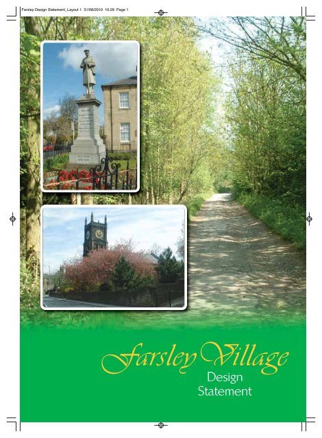
The clock tower of St John’s Church, five<br />
storeys in height, with its clock details painted<br />
in a gold colour, can be seen from Town<br />
Street, Old Road and New Street.<br />
At the northern end of Town Street the<br />
former Council Offices and Cenotaph<br />
provide a local landmark due to their<br />
prominent position.<br />
The final landmark in the area, <strong>Farsley</strong> Celtic<br />
Football Club, is unusual in that it only<br />
becomes a landmark feature when it is in<br />
use. The floodlights provide a very<br />
distinctive visual feature when the lights are<br />
switched on at dark.<br />
<strong>Farsley</strong> Cenotaph<br />
in front of the former Council Offices.<br />
“<br />
The fact that it still<br />
keeps the village<br />
character despite<br />
the increase in<br />
population<br />
”
<strong>Farsley</strong> Design <strong>Statement</strong>_Layout 1 31/08/2010 10:31 Page 19<br />
<strong>Farsley</strong> <strong>Village</strong> Design <strong>Statement</strong><br />
Materials<br />
Within the <strong>Farsley</strong> area the predominant<br />
building material is local sandstone for external<br />
and boundary walls. It is believed that the stone<br />
was quarried from several quarries in the<br />
immediate area. Buildings in the area use two<br />
Architectural Features<br />
In the study area there are a number of common<br />
architectural features that can be found across the<br />
buildings in the historic core. The general<br />
architectural style of the area is typical of the<br />
region with the public buildings, such as the<br />
political clubs or the Co-op, being decoratively<br />
detailed. The majority of the ornate architectural<br />
details are described in greater detail in the listed<br />
building descriptions located in Appendix 2.<br />
Some of the buildings have examples of stone<br />
carvings, which often detail the date of<br />
construction, the name of the organisation who<br />
owned the building at the time of construction, or<br />
the function of the building. These carvings are<br />
generally either located in the centre of the main<br />
façade at eaves level or immediately above the<br />
principal entrance.<br />
<strong>Farsley</strong> Liberal Club<br />
distinctive types of stone block, a rusticated<br />
block having a flat face and a rock face block<br />
having a rougher undulating appearance.<br />
Within the area there are also examples of<br />
buildings which utilise red brick, render and red<br />
clay tiles. These materials are found in the<br />
Farfield area but they are not traditional to the<br />
immediate area, although red brick from<br />
brickworks at Swinnow was used to build many<br />
houses in the 1960s.<br />
Many earlier buildings utilise stone slate as a<br />
roofing material while the later historic buildings<br />
use a composite tile.<br />
Some of the older buildings retain their timber<br />
windows and doors and metal guttering. Many of<br />
the historic buildings have stone surrounds to<br />
the door and window openings and retain their<br />
cast iron rainwater goods, although many have<br />
changed to rot-free uPVC materials<br />
The modern (post 1960s) buildings in the area<br />
utilise a different palette of materials with<br />
external walls constructed of brown or red brick,<br />
roofing tiles of either concrete or artificial slate,<br />
and often uPVC window frames and doors.<br />
Example of architectural details in the area<br />
19
<strong>Farsley</strong> Design <strong>Statement</strong>_Layout 1 31/08/2010 10:31 Page 20<br />
<strong>Farsley</strong> <strong>Village</strong> Design <strong>Statement</strong><br />
The majority of the buildings, particularly the<br />
workers’ terraces, follow a simple functional<br />
architectural style found elsewhere across the<br />
region with well proportioned windows and<br />
simple heads and cills.<br />
A feature of many of the larger terraced and<br />
detached properties is the use of canted bay<br />
windows at ground floor level. This is often<br />
associated with a verandah with a Welsh slate<br />
roof which extends over the entrance to form<br />
a porch<br />
Within the area there are a variety of window<br />
treatments. The heads of the windows vary in<br />
style from simple flat lintels, to segmental<br />
arched heads. Some of the older terraced<br />
properties also have mullioned windows. The<br />
treatment of doorways also varies across the<br />
area from simple stone to more ornate feature<br />
surrounds with corbelled brackets.<br />
The use of decorative coloured clay chimney<br />
pots is also a feature of the area, but these are<br />
rarely visible from the street level.<br />
20<br />
Public Realm<br />
There are a variety of examples of the treatment<br />
of the public realm. Traditionally the streets<br />
were paved with York stone setts. The areas<br />
built in the second half of the twentieth century<br />
however have bland floorscapes that mainly<br />
consist of tarmac surfaces and concrete kerbs,<br />
which do not contribute positively to the<br />
character of the area.<br />
Most of the historic floorscape within the historic<br />
core has been lost or covered over. For<br />
example, along Town Street the York stone flags<br />
have been removed and replaced with modern<br />
concrete paviours, which are not appropriate for<br />
the area. However, to the east of Town Street,<br />
along Back Lane, Prospect Street ,and High<br />
Street, the road has been part-paved with stone<br />
setts, a remedial measure after the original<br />
ancient road surface had been removed to the<br />
detriment of the historic character of <strong>Farsley</strong>.<br />
Stone also plays a large part in the building of<br />
walls and steps.<br />
Examples of architectural details in the area
<strong>Farsley</strong> Design <strong>Statement</strong>.qxp 23/11/10 08:30 Page 21<br />
<strong>Farsley</strong> <strong>Village</strong> Design <strong>Statement</strong><br />
Another feature of the public realm that<br />
adds interest is the small number of historic<br />
street name signs. The signs are made of<br />
metal with raised lettering, painted black<br />
against the white background. Although<br />
relatively few in number, they are an<br />
important feature.<br />
Public rights of way and bridleways are<br />
often known locally as ginnels or snickets.<br />
These routes are important historic<br />
pedestrian routes which have been<br />
retained as dirt tracks or as tarmac<br />
footpaths where they run through modern<br />
housing development. In the rural area to<br />
the west beyond the Ring Road the<br />
bridleways are rough dirt tracks.<br />
The stone setts formerly part of Back Lane<br />
RECOMMENDATIONS<br />
All new development within <strong>Farsley</strong> should be designed so as to relate to its location, paying<br />
particular attention to the following considerations:<br />
I. The materials used should relate well to their immediate surroundings, with<br />
encouragement of the use of natural materials where appropriate.<br />
II. On larger buildings or collections of buildings roof lines and buildings elevations should be<br />
configured and broken down in scale and massing, together with chimney and other roof<br />
detailing so as to achieve a vernacular style sympathetic to the character of the village.<br />
III. Planting schemes should be generous and use locally appropriate species of trees and<br />
shrubs to enable the proposed development to be acceptably integrated into the existing<br />
built form.<br />
IV. New development should provide adequate off-street car parking to serve the needs of<br />
the development without exacerbating existing problems of on-street parking.<br />
V. New residential development should provide appropriate levels of affordable and other<br />
forms of sub-market housing. Such housing should reflect existing housing design and<br />
density.<br />
VI. Traditional road signage and street furniture should be retained and where appropriate<br />
restored. New street furniture should be to a design and quality appropriate to its locality.<br />
VII. Advertising hoardings and other forms of commercial signage should be discouraged.<br />
Such signage is particularly inappropriate in <strong>Farsley</strong> Conservation Area.<br />
VIII. Communication masts or wind turbines should be of a design and scale appropriate to<br />
their location. Careful attention to be given to their material and colour and to residential<br />
amenity. Particular care to be taken within the Conservation Area.<br />
UDPR (2006) Policies GP5, N13, N18-22, BD7-10, T2, T25<br />
Neighbourhoods for Living Supplementary Planning Guidance<br />
PPS1: Planning and Sustainable Development<br />
PPS3: Housing<br />
21
<strong>Farsley</strong> Design <strong>Statement</strong>_Layout 1 31/08/2010 10:32 Page 22<br />
<strong>Farsley</strong> <strong>Village</strong> Design <strong>Statement</strong><br />
Spatial Analysis<br />
In addition to the built form, the character of<br />
<strong>Farsley</strong> is established by several key factors.<br />
These factors – Transport Corridors and<br />
Pedestrian Routes, Nodes and Gateways,<br />
Views, and Open Spaces are described below<br />
and illustrated in Figure 3.<br />
Transport Corridors and Pedestrian Routes<br />
Within the area there are several distinctive<br />
corridors of movement. There are two primary<br />
vehicular routes: the outer Ring Road which runs<br />
along the southern and western edge of the<br />
area, and the Bradford to Leeds Road which<br />
runs from Dawsons Corner in the west to the<br />
Stanningley arches and beyond in the east.<br />
These are heavily trafficked vehicle routes<br />
particularly during the rush hour periods.<br />
The railway line which runs through the southern<br />
fringes of <strong>Farsley</strong>, with New Pudsey train station<br />
is situated in the south-west of the area. At times<br />
the station generates a large number of<br />
pedestrian movements in the immediate vicinity.<br />
The station car park is often full to capacity.<br />
One of the public rights of way leading<br />
indirectly from Town Street to Beck Bottom<br />
Within the outer northern and western areas are<br />
public footpaths across the open ground, several<br />
of which are also bridleways. These public<br />
footpaths continue into the main urban area and<br />
cross into the historic area of <strong>Farsley</strong>. Many of<br />
these footpaths run between buildings and are<br />
known locally as ginnels or snickets.<br />
Fig.3<br />
Gateway<br />
Footpaths<br />
Bridleways<br />
Private recreation facilities<br />
Agricultural land<br />
Formal public open space<br />
22<br />
Natural open space<br />
Water<br />
Primary transport corridor<br />
Secondary transport corridor<br />
Nodes<br />
Roof top views<br />
Local landmark
<strong>Farsley</strong> Design <strong>Statement</strong>_Layout 1 31/08/2010 10:32 Page 23<br />
<strong>Farsley</strong> <strong>Village</strong> Design <strong>Statement</strong><br />
RECOMMENDATIONS<br />
1. Existing footpaths and bridleways (known locally as ginnels and snickets) should be<br />
retained and where appropriate extended and improved in order to preserve and<br />
enhance the amenity these routes afford pedestrians and cyclists. These to include:<br />
a. Signposts, waymarkers, appropriate resurfacing, and lighting.<br />
b. Provision of refuse and dog litter bins.<br />
2. Encouragement should be given for initiatives which will improve and extend the<br />
network of local paths in and around <strong>Farsley</strong>.<br />
These to include:<br />
a. A pedestrian crossing over the Ring Road at Calverley Lane.<br />
b. A pedestrian crossing at Rodley roundabout.<br />
c. A review of the safety of existing rights of way crossing the Ring Road.<br />
d. A review and/or the creation of pedestrian routes between Nodes<br />
3. Where reasonably practicable footpaths and bridleways should be designed to<br />
enable access for all.<br />
UDPR (2006) Policies GP5, T5-7<br />
Neighbourhoods for Living Supplementary Planning Guidance<br />
PPS1: Planning and Sustainable Development<br />
Nodes and Gateways<br />
The area has several nodes: these are places<br />
where traffic congregates, roads meet, or<br />
people gather on a regular basis. New<br />
Pudsey Station attracts many people who<br />
use the train to commute to and from the<br />
area. Pudsey Civic Hall is a local resource<br />
which frequently attracts many visitors from<br />
outside the area, particularly when societies,<br />
groups, or commercial organisations hold<br />
events at weekends.<br />
The main activity within the core of the area<br />
is generated during the normal working<br />
week by the core shops lining Town Street,<br />
while the pubs, political clubs, bars and<br />
restaurants provide activity in the evenings<br />
and at the weekends.<br />
Pudsey Civic Hall<br />
23
<strong>Farsley</strong> Design <strong>Statement</strong>_Layout 1 31/08/2010 10:32 Page 24<br />
<strong>Farsley</strong> <strong>Village</strong> Design <strong>Statement</strong><br />
Church halls are also active centres with local<br />
groups utilising the facilities in the daytime,<br />
evening and weekends. Such facilities are<br />
often the most appropriate for the young<br />
and the old of the village.<br />
Also, the Owlcotes Retail Park, which<br />
currently comprises Asda and Marks and<br />
Spencer, provides a hub of activity. This<br />
node creates heavy traffic movements from<br />
out of the area, especially at weekends.<br />
Celebrating its Centenary year in 2009,<br />
<strong>Farsley</strong> Celtic, with its adjacent sports hall,<br />
provides activity to the area (especially with<br />
the use of the football ground for matches<br />
on Saturday afternoon). The club attracts<br />
locals and visitors to the area, involving high<br />
traffic movements for relatively short<br />
periods.<br />
Since it was founded in 1864 <strong>Farsley</strong> Cricket<br />
Club has helped to launch a number of local<br />
players to a high level within the sport.<br />
Some familiar cricket names are still actively<br />
involved with the club, encouraging players<br />
as young as 8 into the sport. Situated for<br />
many years at Red Lane, the location of the<br />
ground however was never selected with<br />
modern vehicular traffic movement in mind.<br />
In addition to the local public houses and<br />
cafes, function rooms such as The Manor<br />
could also be considered nodes, attracting<br />
groups of people and traffic within specific<br />
controlled hours.<br />
Dawsons Corner<br />
The sense of arrival into the area via the<br />
Dawsons Corner roundabout gateway is<br />
announced by the landmark office buildings<br />
and Civic Hall.<br />
Richardshaw Lane<br />
The sense of arrival into the urban area<br />
from the Ring Road is dramatically<br />
announced by the entry via Richardshaw<br />
Lane through the Stanningley Viaduct<br />
A landmark feature which provides a visual<br />
clue to the arrival in the area.<br />
The Stanningley Viaduct<br />
Historically utilised as trade and retail units,<br />
also acts as the gateway to the area along<br />
Stanningley Road.<br />
Coal Hill Lane<br />
The gradient at this gateway allows short<br />
distance views with Marsden Court<br />
dominating.<br />
Bagley Lane<br />
The traditional stone terraces with a<br />
backdrop of fields on the west side of the<br />
road mark this gateway from Rodley.<br />
Calverley Lane<br />
Gateway from the Ring Road, the sheer<br />
volume of vehicular traffic announcing<br />
arrival into the area. Priesthorpe Road is<br />
also a minor gateway from the Ring Road.<br />
Along the highway networks are a number of<br />
significant entrance points which may be<br />
referred to as ‘Gateways’. The boundary of<br />
the study area has influenced the arrival<br />
points or gateways into the area which is why<br />
some of the gateways listed are less obvious<br />
than others:<br />
24
<strong>Farsley</strong> Design <strong>Statement</strong>_Layout 1 31/08/2010 10:32 Page 25<br />
<strong>Farsley</strong> <strong>Village</strong> Design <strong>Statement</strong><br />
RECOMMENDATIONS<br />
1. Consideration should be given to improvements of the highway network in <strong>Farsley</strong>.<br />
These to include:<br />
I. Extension of bus routes to include links to New Pudsey Station<br />
II. Vehicular access from Pavilion Fields/Newlands to Vickersdale.<br />
2. Consideration should be given to traffic calming in order to improve road safety and<br />
residential amenity in the village.<br />
3. Consideration should be given to improvements to parking provision in <strong>Farsley</strong>.<br />
These to include:<br />
I. Existing public parking spaces clearly defined.<br />
II. Provision of extended parking for local businesses to release spaces in public car<br />
parks.<br />
III. Particular attention paid to tighter control of parking at hazardous junctions and<br />
rights of way crossings.<br />
IV. Appropriate parking and access for those with disabilities in all new developments.<br />
UDPR (2006) Policies GP5, T2, T24<br />
Neighbourhoods for Living Supplementary Planning Guidance<br />
PPS1: Planning and Sustainable Development<br />
PPG13: Planning and transport<br />
“<br />
It is just a nice<br />
size with a little<br />
bit of everything<br />
and I have lived<br />
here forty-eight<br />
years<br />
”<br />
St John’s Church Hall<br />
25
<strong>Farsley</strong> Design <strong>Statement</strong>_Layout 1 31/08/2010 10:32 Page 26<br />
<strong>Farsley</strong> <strong>Village</strong> Design <strong>Statement</strong><br />
Views, Soft Landscaping<br />
and Open Spaces<br />
Due to the location of <strong>Farsley</strong> on the southern<br />
side of the River Aire long distance views into<br />
the area are possible from the opposite side of<br />
the Aire valley. The contours of the land also<br />
provide the opportunity for views across the<br />
area from higher ground into the village.<br />
(See Fig 3).<br />
Linear views are also possible along the primary<br />
highways of Town Street and Old Road, looking<br />
North across the Aire valley towards Horsforth,<br />
Rawdon and beyond.<br />
Within the area there is a variety of soft<br />
landscaping and open spaces. Some residential<br />
properties have mature trees in their front and<br />
rear gardens which provide a soft edge to the<br />
urban form along New Street and Bradford Road.<br />
Within the main urban area the principal open<br />
spaces are the maintained public recreation<br />
facilities such as the recreation ground on<br />
Calverley Lane and the formal gardens of<br />
Westroyd Park.<br />
In contrast to the public parks and gardens<br />
there are more natural landscapes such as<br />
Beck Bottom and Wood Nook which are<br />
semi-rural areas with grassland and<br />
collections of trees important for habitat and<br />
biodiversity. To the west, the agricultural use<br />
of the land creates a different appearance<br />
from the rest of the area. The enclosed fields<br />
are primarily used for livestock farming or<br />
crop farming and the appearance of the<br />
latter changes significantly when the fields<br />
are ploughed.<br />
In addition to the natural open spaces, the<br />
man-made dam used by Sunnybank Mill<br />
throughout its life as a manufacturing centre<br />
has now become an established haven not<br />
only for wildlife, but also for the natural<br />
habitat that has grown around it.<br />
26<br />
Water and trees create a natural environment for<br />
wildlife and plants where man no longer has a use
<strong>Farsley</strong> Design <strong>Statement</strong>.qxp 11/10/10 12:10 Page 27<br />
<strong>Farsley</strong> <strong>Village</strong> Design <strong>Statement</strong><br />
RECOMMENDATIONS<br />
1. Existing greenspace, indicated on the village map, should not be built or<br />
encroached upon.<br />
2. Ecologically and recreationally valuable woodland, trees, ponds and other<br />
landscape and wildlife features should be protected from development.<br />
3. Appropriate tree planting and landscaping should be encouraged and supported<br />
throughout the village and adequate and suitable maintenance provided.<br />
4. Improvements to facilities and infrastructure of the following Parks and open spaces<br />
should be encouraged and supported:<br />
I. Hainsworth Park<br />
II. Calverley Lane Play Area (aka “The Rec”) - completed<br />
III. Westroyd Park<br />
IV. Farfield Play Area<br />
5. Where appropriate any planning permission granted for development in the village<br />
should be subject to planning conditions and/or obligations that:<br />
I. Improve or provide the means to improve the quality and provision of<br />
greenspace and streetscape locally.<br />
II. Protect and enhance landscaping and ecology.<br />
6. Development which may obstruct or harm existing public views of significant<br />
features within the village or significant views of the surrounding open landscape<br />
should be resisted.<br />
UDPR (2006) Policies GP5, N1-10<br />
Neighbourhoods for Living Supplementary Planning Guidance<br />
PPS1: Planning and Sustainable Development<br />
PPS3: Housing<br />
Public Facilities<br />
Within the boundary outlined in the FVDS<br />
are a number of facilities available to the<br />
public through local or national provision.<br />
Due mainly to the benevolence of its millowning<br />
families, <strong>Farsley</strong> has been fortunate<br />
enough to have access to a number of<br />
recreational areas since Victorian days.<br />
Hainsworth Park and Westroyd Park ,along<br />
with the <strong>Farsley</strong> Recreation Ground and<br />
Farfield Play Area, continue to provide<br />
areas where local residents may enjoy a<br />
walk, take part in more energetic sporting<br />
activities or take their children to the<br />
dedicated playgrounds.<br />
Westroyd Park<br />
27
<strong>Farsley</strong> Design <strong>Statement</strong>.qxp 23/11/10 08:30 Page 28<br />
<strong>Farsley</strong> <strong>Village</strong> Design <strong>Statement</strong><br />
<strong>Farsley</strong>’s particular historic connection with<br />
the textile industry and sheep farming is<br />
commemorated by the Marsden Memorial in<br />
what the locals often refer to as Sheepshead<br />
Park, a small area where local people can sit<br />
and relax, but still be in the centre of the<br />
village activity. Natural Open Spaces are<br />
shown in Figure 3, where one of the most<br />
exciting recent developments has been the<br />
establishment of a “green pathway” between<br />
Beck Bottom and Newlands.<br />
A number of existing public facilities are<br />
considered to be essential to the village, and<br />
these are duly noted in the<br />
recommendations. It is worth noting that the<br />
facilities available at the time of producing<br />
this document include Springbank, Westroyd<br />
Infants and Nursery and Farfield Schools,<br />
<strong>Farsley</strong> Library, the village-based doctors,<br />
chemists, dental surgeries and the Post Office.<br />
The provision of public toilets for locals and<br />
visitors is also considered essential. It is interesting<br />
to note that within living memory the village also<br />
had its own fire station and police house.<br />
Marsden Memorial Garden<br />
RECOMMENDATIONS<br />
1. Retail, office and leisure development of an appropriate scale should be located within<br />
<strong>Farsley</strong> town centre. Particular support will be given to shops and services which<br />
provide for people’s day to day needs.<br />
2. When considering a proposal for the change of existing facilities, particularly the shops,<br />
public houses and other amenities, account should be taken of the impact it will have<br />
on the vitality and viability of the village.<br />
3. Proposals for additional community facilities, particularly in the re-use of empty mill<br />
buildings, should be encouraged and supported.<br />
4. Public service provision, including doctors and dental surgeries, should be located to<br />
provide convenient access for village residents.<br />
5. Appropriate public toilets with convenient access for residents and visitors should be<br />
provided and managed in such a way as to discourage misuse.<br />
6. Seating should be provided throughout the area at locations selected after local<br />
consultation with particular consideration to locating seating in areas of hilly terrain.<br />
UDPR (2006) Policies GP5, S2–S6<br />
Neighbourhoods for Living Supplementary Planning Guidance<br />
PPS1: Planning and Sustainable Development<br />
PPS4: Planning for Sustainable Economic Growth<br />
28
<strong>Farsley</strong> Design <strong>Statement</strong>_Layout 1 31/08/2010 10:33 Page 29<br />
<strong>Farsley</strong> <strong>Village</strong> Design <strong>Statement</strong><br />
APPENDICES…<br />
Appendix 1 –<br />
Community Involvement<br />
Appendix 2 –<br />
Listed buildings<br />
Appendix 3 –<br />
The History and Evolution of <strong>Farsley</strong><br />
Appendix 4 –<br />
Non Planning Community Suggestions<br />
Appendix 5 –<br />
Acknowledgements & Resume of FVDSG<br />
Appendix 1<br />
Community Involvement<br />
Initially two Public Meetings were held and<br />
attendees were invited to volunteer their<br />
services in setting up a group to oversee<br />
the writing of a Design <strong>Statement</strong> for the<br />
village of <strong>Farsley</strong>. At the time there was no<br />
standard for the design of such a document<br />
in a suburban area as these had only been<br />
sought in rural areas and as such it was<br />
hoped that <strong>Farsley</strong> would become a<br />
pioneering scheme. The group then<br />
formed a more formal committee receiving<br />
funding from the West Area Committee of<br />
the City Council. Based upon natural,<br />
political and historical boundaries an area<br />
was outlined to which the Design <strong>Statement</strong><br />
would apply.<br />
Public interest was encouraging and the<br />
response was far greater than anticipated.<br />
Local press and posters displayed in various<br />
sites were used to publicise the project<br />
throughout the designated area.<br />
“<br />
We don’t want it<br />
spoiling with<br />
modern buildings<br />
in the centre<br />
”<br />
Workshop<br />
During a third public meeting those present<br />
split into two brainstorming groups to<br />
consider certain open-ended questions.<br />
This resulted in the following suggestions<br />
(many of which have been reflected within<br />
the main body of the document):<br />
29
<strong>Farsley</strong> Design <strong>Statement</strong>.qxp 11/10/10 12:11 Page 30<br />
<strong>Farsley</strong> <strong>Village</strong> Design <strong>Statement</strong><br />
30<br />
Blue Group Results<br />
Q1 What are the characteristics of <strong>Farsley</strong> which<br />
you would like to see preserved<br />
Ginnels and Footpaths<br />
Balance between conflicting needs of say parking,<br />
pedestrians, shops, through traffic – adequate<br />
parking spaces<br />
Co-op parking not used due to fears of being<br />
blocked in<br />
Planned reduction in parking spaces<br />
Encourage employees to park elsewhere<br />
Green Spaces (including all parks)<br />
Independent Shops<br />
Old Buildings – developments should retain existing<br />
features and/or blend in, especially old stone<br />
One narrow street with its effects on geography and<br />
sociology<br />
Restrict loading times for HGVs<br />
Schools<br />
No more high-rise developments<br />
Employment<br />
Q2 Are there specific characteristics to the<br />
different areas of the village<br />
Parts of Stanningley should be in historic core –<br />
Sunfield/ Hainsworths<br />
Other areas work but Stanningley is more of a<br />
hotchpotch – is it all part of <strong>Farsley</strong> or should<br />
boundary be Leeds Bradford Road with say<br />
Richardshaw Lane belonging to Pudsey, Bramley, or<br />
Stanningley<br />
Q3 What types of development threaten to<br />
change the character of the village<br />
Housing generally!<br />
Housing as dormitories for those based in say Leeds<br />
Estate building<br />
Licensing hours etc (encourage late night drunks)<br />
Number of same trade competitors<br />
Q4 What types of development would you like to<br />
promote<br />
Litter Bins<br />
Tourist Information type maps<br />
Family affordable housing to avoid forcing some<br />
people to move out of the area<br />
Facilities for youth<br />
Youth clubs<br />
Youth shelter<br />
Programmes for youth + seniors to meet<br />
Mention of Community Festival<br />
Scout group needing parental support<br />
Awareness of youth causing problems for which<br />
planned CCTV may assist, but counter argument of<br />
trying to make youth wanted. They should be made<br />
to feel included rather than excluded.<br />
Red Group Results<br />
Open spaces throughout the village were<br />
seen as a positive. It still feels like a "one<br />
street" village<br />
There are a variety of shops (although this is<br />
declining with some key ones missing)<br />
Recent tree planting is seen as a positive<br />
Sheepshead Park is a positive<br />
Traffic needs slowing down<br />
Rat running is an issue<br />
(partially caused by delays on the Ring Rd)<br />
Parking is an issue (Co-op car park is not<br />
used much due to access problems)<br />
Residents like the old cobbled streets<br />
Several wooded areas need protecting<br />
The old dancing school needs preserving<br />
Facilities within greenspaces, such as tennis<br />
courts and play areas, are a positive (although<br />
lack of something like a skate park were<br />
raised as an issue)<br />
Facilities for young people are important<br />
Football wall/pitch were suggested<br />
Young people's views need to be considered<br />
Sunnybank Mill is central to the village and<br />
needs protecting. UPVC windows in old<br />
properties seen as not in keeping. Need to<br />
place Tree Preservation Orders on<br />
established trees. Springbank valley needs<br />
protecting as the right of way is being<br />
encroached upon<br />
Sites which may become available are Tradex;<br />
Woodhouse Mill; Dancing School<br />
Yorkshire stone is prevalent in the older parts<br />
of the village. Modern buildings are not a<br />
problem if designed to a good quality and<br />
high standard<br />
There are relatively few listed buildings<br />
Alternative uses are needed for old buildings<br />
rather than demolition<br />
It was noted that, whatever current feeling,<br />
this consultation would only be a snapshot of<br />
current opinion and may change over time.
<strong>Farsley</strong> Design <strong>Statement</strong>_Layout 1 31/08/2010 10:33 Page 31<br />
<strong>Farsley</strong> <strong>Village</strong> Design <strong>Statement</strong><br />
Questionnaire<br />
Approximately 4000 locally printed<br />
questionnaires were designed and posted in<br />
June 2006 to all households within the<br />
boundary in order to obtain the views of<br />
people living in the area.<br />
Local interest in the project was evident by the<br />
return of more than 1 in 4 questionnaires.<br />
(Statistically a very significant response rate)<br />
Chart 1 shows the spread by age and gender<br />
the majority of those answering being in the<br />
30 – 60 age group.<br />
Chart 3 – Good or Bad in <strong>Farsley</strong><br />
Very Good Good Bad Very Bad<br />
Residents’<br />
Parking<br />
Safe walking<br />
to school<br />
Cycle paths<br />
Pedestrian<br />
crossings<br />
Chart 1 – Age and Sex of Respondents<br />
Pavement<br />
maintenance<br />
Road<br />
maintenance<br />
Bus services<br />
Car parking<br />
provision<br />
Chart 2 – How Safe do I feel in <strong>Farsley</strong><br />
78% of residents<br />
felt safe<br />
all or most of<br />
the time<br />
Chart 3 dealt with a range of topics.<br />
<strong>Farsley</strong>’s bus service was considered good or<br />
very good, but there were suggestions that a<br />
circular school bus route would be a good<br />
idea as this would help keep traffic away from<br />
schools.<br />
There was some demand for more<br />
pedestrian crossings and improved<br />
pavement maintenance.<br />
It is evident that the provision and upkeep<br />
of cycle paths in the area is in need of<br />
attention.<br />
31
<strong>Farsley</strong> Design <strong>Statement</strong>_Layout 1 31/08/2010 10:33 Page 32<br />
<strong>Farsley</strong> <strong>Village</strong> Design <strong>Statement</strong><br />
The conflict between pedestrian and<br />
vehicular usage was highlighted by the large<br />
concern regarding anti-social and pavement<br />
parking, speeding traffic and rat running. Car<br />
parking provision was also considered<br />
inadequate and in need of improvement.<br />
Chart 5 – Important Facilities<br />
Very Fairly Not Very Not at all<br />
Chart 4 – Vehicle problems on your street<br />
Very Often Often Not Often Never<br />
Food shops<br />
Hairdressers etc<br />
Fast food shops<br />
Post Office<br />
Chemist<br />
Other shops<br />
Antisocial<br />
parking<br />
Library<br />
Doctors<br />
Dentist<br />
Parking on<br />
pavements<br />
Restaurant/Café<br />
Pub<br />
Pre-school clubs<br />
Rat running<br />
Primary schools<br />
High schools<br />
Community centre<br />
Car noise<br />
at night<br />
Speeding<br />
traffic<br />
Inability to<br />
park<br />
Meeting rooms<br />
Places of worship<br />
Sports facilities<br />
Allotments<br />
Litter bins<br />
Green space<br />
Play facilities<br />
Other<br />
The relative importance to respondents of a wide<br />
range of facilities is reflected in Chart 5, which in<br />
particular makes clear the significance of the Post<br />
Office, Doctors Surgery, and Dispensing Chemists.<br />
32
<strong>Farsley</strong> Design <strong>Statement</strong>_Layout 1 31/08/2010 10:33 Page 33<br />
<strong>Farsley</strong> <strong>Village</strong> Design <strong>Statement</strong><br />
Chart 6 – Satisfaction with Recreation<br />
Facilities<br />
Chart 7 – How important are Aspects<br />
Very Fairly Not Very Not at all Very Fairly Not Very<br />
Not at all<br />
Playing fields<br />
Children’s<br />
playgrounds<br />
Preservation of<br />
character<br />
Tennis courts<br />
Bowling greens<br />
Protection of<br />
Green Belt<br />
Sports pitches<br />
Flower beds<br />
Conservation<br />
Areas<br />
Hanging baskets<br />
Park grounds<br />
Enforcement of<br />
Planning/Building<br />
Park seating<br />
Play groups<br />
Footpaths<br />
and/bridle/cycle<br />
ways<br />
Youth clubs<br />
Housing for the<br />
young<br />
Retirement clubs<br />
After school clubs<br />
Housing for the<br />
elderly<br />
Internet Cafes<br />
Christmas lights<br />
Road design &<br />
traffic management<br />
Bus shelters<br />
Chart 6 indicates the level of satisfaction with a<br />
wide range of recreational facilities.<br />
This also proves that one third of those<br />
answering the questionnaire made regular use of<br />
our parks and outdoor areas thus indicating their<br />
importance to the village.<br />
Chart 7 shows perhaps the most important<br />
conclusion – that there was very widespread support<br />
for all measures designed to protect the existing<br />
character of the village, its green belt, and its<br />
Conservation Area, and support even for council<br />
enforcement activity. Dissatisfaction is suggested<br />
however for provision and facilities catering for the<br />
young and the elderly in the community, both in<br />
housing and in recreational activities shown in the<br />
preceding Chart. Anecdotal evidence suggests this<br />
conclusion has not changed since the return of the<br />
questionnaires in June 2006.<br />
33
<strong>Farsley</strong> Design <strong>Statement</strong>_Layout 1 31/08/2010 10:33 Page 34<br />
<strong>Farsley</strong> <strong>Village</strong> Design <strong>Statement</strong><br />
Schools<br />
With the co-operation of the local Primary<br />
schools <strong>Farsley</strong> children in Year 6 completed<br />
a simplified survey on their usage of local<br />
facilities and changes which they would like<br />
to see in the village.<br />
The results showed that the most popular<br />
recreational use was made of the local parks<br />
followed in numbers by the two sports clubs<br />
facilities at Celtic and the Cricket club. The<br />
library was well used and a few were<br />
members of the Brownies and the Boys<br />
Brigade.<br />
When asked what changes they would most<br />
like to see in <strong>Farsley</strong>, a Leisure Centre was<br />
the most requested. This was followed by<br />
facilities for swimming, and other outdoor<br />
sports. Their views about the village often<br />
paralleled those of the adults – especially a<br />
desire to clean up and see less litter in parks<br />
and streets. They would also like facilities<br />
for bowling, cinema, and more child centred<br />
clubs and indoor activities.<br />
Conclusion<br />
Subsequently with a huge amount of material<br />
to analyse the project involved many hours<br />
of official and voluntary time. Working<br />
closely with planning officers and Councillors<br />
many suggested projects were completed<br />
during the progress of this full analysis, i.e.<br />
railings around several sites, improvements to<br />
the library and flats area, and the retention<br />
of cobbled setts leading off Town Street.<br />
Some traffic calming projects have been<br />
implemented but they still need to be<br />
refined and improved. Controversial<br />
planning applications have been monitored<br />
and also problems of parking.<br />
34<br />
Westroyd House
<strong>Farsley</strong> Design <strong>Statement</strong>.qxp 11/10/10 12:12 Page 35<br />
<strong>Farsley</strong> <strong>Village</strong> Design <strong>Statement</strong><br />
Appendix 2<br />
Listed Buildings<br />
This Appendix to the <strong>Farsley</strong> <strong>Village</strong> Design<br />
<strong>Statement</strong> records the location and details as<br />
at the date of publication. A variation of the<br />
map Fig 4 shown below is also included (as<br />
Fig 1) in the main body of the Design<br />
<strong>Statement</strong>.<br />
Fig 4. Location of Listed Buildings<br />
Within the study area there are 15 buildings<br />
or structures that have “listed building” status.<br />
These buildings are listed by English Heritage<br />
on account of their special architectural or<br />
historic interest in a national context. Close<br />
historical association and group value can also<br />
be a consideration. They are classified into<br />
three grades:<br />
Grade I - exceptional importance<br />
Grade II* - particularly important<br />
Grade II - of special interest.<br />
Conservation Area Boundary 1989<br />
Listed Buildings<br />
Fig.4<br />
35
<strong>Farsley</strong> Design <strong>Statement</strong>_Layout 1 31/08/2010 10:34 Page 36<br />
<strong>Farsley</strong> <strong>Village</strong> Design <strong>Statement</strong><br />
1 <strong>Farsley</strong> National Schools<br />
New Street<br />
Grade II<br />
School. C1848. Hammer-dressed stone,<br />
Welsh blue-slate roof. 2 storeys, 4 bays. 1st bay<br />
has former doorway (altered to window) with<br />
double-chamfered surround with above, and to<br />
other bays, 2-light double-chamfered mullioned<br />
windows. Above ground-floor window is<br />
ornamental band with relief inscription:<br />
“NATIONAL FARSLEY SCHOOLS”.<br />
Coped gables. End stack to right.<br />
2 Former Bagley (Rehobeth)<br />
Baptist Chapel<br />
Bagley Lane<br />
Grade II<br />
Former Baptist Church partly converted to<br />
industrial use. Dated 1836. Dressed stone,<br />
asbestos roof. 2 storeys. 5-bay symmetrical façade.<br />
Plinth and band. Tall doorways with monolithic<br />
lintels and overlights in 2nd and 4th bays. All other<br />
bays have windows with projecting sills, those to<br />
ground floor boarded over, those to 1st floor<br />
retaining 16-pane sashes. Hollow-chamfered<br />
moulding to stone gutter. Hipped roof. Dare<br />
plaque to centre under eaves. Left-hand return has<br />
6 bays of similar windows, the 3rd bay altered with<br />
large taking-in door breaking 1st floor band.<br />
1.<br />
36<br />
3 Former Congregational Chapel<br />
No. 62 Bradford Road<br />
Grade II<br />
Former Congregational Chapel now in industrial<br />
use. C1852 by Lockwood & Mawson. Gothic<br />
Revival. Early English lancet style. Hammer-dressed<br />
sandstone. Westmorland green-slate roof. Single<br />
storey. Steeply-gabled entrance front with gabled<br />
angle buttresses. Central shallow gabled porch in<br />
which are recessed deeply-moulded paired portals<br />
under one arch which is recessed for 2 orders and<br />
shafted, the tympanum containing a corbelled<br />
niche with angel statuette supported on a foliatecapped<br />
corbel-head. Dripmould to arch is deeply<br />
undercut with foliate stops. Good iron door<br />
furniture. Set above is a triple group of well<br />
proportioned shafted lancets. Coped gables with<br />
kneelers, apex finial. Right and left returns of 5<br />
bays. Each bay has pairs of chamfered lancets<br />
articulated by shallow buttresses. A convincing if<br />
modest design finely executed.<br />
2.<br />
3.
<strong>Farsley</strong> Design <strong>Statement</strong>_Layout 1 31/08/2010 10:34 Page 37<br />
<strong>Farsley</strong> <strong>Village</strong> Design <strong>Statement</strong><br />
4 Former Council Offices<br />
No. 2 Calverley Lane<br />
Grade II<br />
Former district council offices and library now<br />
partly occupied as house and offices. C1840.<br />
Ashlar, Welsh blue slate roof. 2 storeys with attic<br />
and cellar. Square on plan with doorways to all 4<br />
sides. 3-bay symmetrical façade to road has<br />
pilastered doorcase with entablature, cornice and<br />
blocking course. Flanking ground-floor windows<br />
have architraves and panelled aprons. 3 windows<br />
to 1st floor have projecting sills. All retain 18-pane<br />
sashes. Eaves band and stone gutter. Hipped roof<br />
with 2 end stacks to left and one other to right.<br />
Rear has tall doorway with monolithic jambs and<br />
margin-glazed overlight flanked windows with<br />
lintels and sill on both floors with large taking-indoorway<br />
with double doors to 1st floor, centre.<br />
Square gutter brackets. Left-hand return has<br />
central doorway with overlight with tall narrow<br />
window above and flanking windows on ground<br />
floor only. Gutter brackets. Right-hand return has<br />
one bay of windows for house to left of doorway<br />
with wooden surround and large shop window<br />
with arch-headed glazing. 3 sash windows above.<br />
Stone gutter. Attached to wall on this elevation is<br />
marble plaque recording the fallen of the<br />
“SOUTH AFRICAN WAR 1899-1902”.<br />
5 Former Olivet Chapel<br />
Bradford Road<br />
Grade II<br />
Former Olivet Methodist & United<br />
Reformed Church GVII United Methodist<br />
Chapel now in commercial use. C1856.<br />
Ashlar façade, hammer-dressed stone to<br />
sides and rear, Welsh blue-slate roof. Low<br />
single storey. Pediment gabled 3-bay<br />
symmetrical façade. Plinth, angle pilasters<br />
above which moulded cornice breaks<br />
forward, moulded coping to pediment.<br />
Doorway has raised monolithic jambs,<br />
imposts and panelled spandrels and dentil<br />
cornice with blocking course; the reveals<br />
and soffit panelled and splayed. Tall flanking<br />
round-headed windows with architraves and<br />
sill band, panelled spandrels rise into<br />
cornice with sections of blocking course<br />
above. Tympanum has oculus with<br />
architrave. Left and right returns have 5<br />
bays of plain arched windows with small<br />
voussoirs and projecting sills. Eaves cornice.<br />
Interior: stair-hall has full-height open-string stair,<br />
with paired, slender, turned balusters and<br />
wreathed and ramped handrail. Main sitting room<br />
has doorway with architrave, deep skirting and<br />
finely-moulded ceiling cornice with central<br />
foliated boss. Cellar lit by sash windows below<br />
ground has original fireplace with stone shelf, setpot<br />
and long stone sink.<br />
5.<br />
4.<br />
“<br />
The fact that it still<br />
keeps the village<br />
character despite<br />
the increase in<br />
population<br />
”<br />
37
<strong>Farsley</strong> Design <strong>Statement</strong>_Layout 1 31/08/2010 10:34 Page 38<br />
<strong>Farsley</strong> <strong>Village</strong> Design <strong>Statement</strong><br />
6 Former Stanningley Baptist Church<br />
and attached Ministers House<br />
Richardshaw Lane<br />
Grade II<br />
Former Stanningley Baptist Church and<br />
attached Ministers House. Dated 1827.<br />
Now offices. Hammer-dressed stone. Welsh<br />
blue-slate roofs.<br />
2 storeys. Chapel: almost square in plan.<br />
5 bay symmetrical gabled façade. Plinth,<br />
band, eaves band defining pediment gable.<br />
Bays 2 and 4 have doorways with overlights<br />
and cornices on brackets. Bays 1,3 and 5<br />
and all those above have windows, with<br />
margin glazing, thin lintels and slightly<br />
projecting sills. Central corniced date plaque.<br />
Set in tympanum is an oeil-de-boeuf. Coped<br />
gable. Left and right returns have 5 bays of<br />
similar windows to each floor. Attached and<br />
set back to right is Minister’s house:<br />
doorway with monolithic jambs to left of 2<br />
bays of windows with lintels and sills (all<br />
blocked). Gutter brackets. Coped gable<br />
with tall end stack to right. Interior: Chapel:<br />
corner dog-leg stairs have slender turned<br />
balusters. Good raised-and-fielded-panel<br />
gallery carried on slender cast-iron columns,<br />
canted at entrance end. Original box pews.<br />
Semi-octagonal pulpit (mid C19) with original<br />
stairs.<br />
6.<br />
“<br />
”<br />
Town Street<br />
still retains<br />
elements of its<br />
history<br />
38<br />
7 Headmasters House<br />
Town Street<br />
Grade II<br />
Headmaster’s house for <strong>Farsley</strong> National<br />
Schools (q.v). c1848. Hammer-dressed<br />
stone, Welsh blue-slate roof. 2 storeys and<br />
attic. 3-bay symmetrical façade. Central bay<br />
projects and has doorway with chamfered<br />
architrave and hoodmould. 2-light chamfered<br />
mullioned window above crowned by gabled<br />
dormer with small attic light. Flanking bays<br />
have 2-light chamfered mullioned windows<br />
to each floor, those to ground floor with<br />
hoodmoulds.<br />
Coped gables with moulded ashlar coping<br />
and end stacks, that to right corbelled with<br />
paired diagonally-placed flues. Fronts main<br />
street with <strong>Farsley</strong> National Schools at right<br />
angles to rear.<br />
7.
<strong>Farsley</strong> Design <strong>Statement</strong>_Layout 1 31/08/2010 10:34 Page 39<br />
<strong>Farsley</strong> <strong>Village</strong> Design <strong>Statement</strong><br />
8 Leigh House<br />
Varley Street<br />
Grade II<br />
Leigh House – II House, now offices.<br />
Early-mid C19. Finely dressed sandstone,<br />
Westmoreland green-slate roof, 3 and 2<br />
storeys. Main house has central doorway<br />
with segmental lintel and splayed panelled<br />
jambs, engaged Ionic columns, entablature<br />
and dentil cornice. 4-pane sashes in<br />
architraves. Dentil eaves cornice. Hipped<br />
roof with 2 end stacks. Wing hipped to<br />
left. Rear has 2 tall round-headed stair<br />
windows one above the other.<br />
8.<br />
9 Old Poplar Farmhouse<br />
Bagley Lane<br />
Grade II<br />
Farmhouse. Early c18 altered early c19<br />
coursed rubble partly rendered with<br />
quoins. Stone slate roof with 2 gable<br />
stacks, coped gables and kneelers. 2<br />
storeys. East front has a single window<br />
opening to the left, and a pair of window<br />
openings. South front has 2, 2 light mullion<br />
windows on the ground floor with<br />
chamfered surrounds, and a continuous<br />
drip mould above a pair of window<br />
openings. The rendered west front has 2<br />
doorways in the ground floor, and 2 pairs<br />
of windows above. The north front is<br />
largely obscured by a single storey<br />
addition, now in a ruinous state, above a<br />
pair of window openings. All the window<br />
frames and doors have been removed.<br />
Interior: the 2 ground floor rooms to the<br />
south contain chamfered spine beams, and<br />
large stone fireplaces. That to the east has<br />
a chamfered four-centred arched surround<br />
with a later, smaller plain surround<br />
inserted, that to the west is larger, with a<br />
chamfered, and curved surround also<br />
containing a later, and smaller plain<br />
inserted surround. This building has been<br />
used in recent years as an animal shelter or<br />
hay store.<br />
9.<br />
10.<br />
10 Old Poplar Farmhouse Cowshed<br />
Bagley Lane<br />
Grade II<br />
Cowshed. Early c18 with c20 alterations. Coursed<br />
rubble with quoins and a stone slate roof. Single storey.<br />
East gable front has a doorway, and the north front has<br />
a boarded 2 light window. Interior has original roof with<br />
king post truss with thin queen posts, ridge piece and<br />
passing purlins. Included for group value only.<br />
39
<strong>Farsley</strong> Design <strong>Statement</strong>_Layout 1 31/08/2010 10:34 Page 40<br />
<strong>Farsley</strong> <strong>Village</strong> Design <strong>Statement</strong><br />
11 St John’s Church<br />
New Street<br />
Grade II<br />
Church. C1842/3 by William Wallen (Huddersfield).<br />
Tower rebuilt c 1895 by A. Child (Calverley), porch<br />
c1898. 4-stage west tower, south porch, nave,<br />
chancel, north transept. Gothic Revival Early<br />
English lancet style. Plinth, sill band. Tower: gabled<br />
porch attached to south. Angle buttresses with<br />
gabled offsets. 2nd stage: ingle light flanked by<br />
smaller blind windows. 3rd stage has 5-light window<br />
with 2 belfry lights. 4th stage: clasping buttresses<br />
surmounted by pinnacles, clock-face to each side.<br />
Lombard frieze and parapet. Nave: 6 bays<br />
articulated by gabled buttresses. Corbel table.<br />
Coped gable. Lower 2-bay chancel has 3-light east<br />
windows with vesica (blind) above. Offset angle<br />
buttresses. Coped gable surmounted by cross.<br />
North transept attached to 1st bay of chancel has<br />
twin gables.<br />
Interior: single vessel with 6-bay queen-post roof.<br />
West gallery carried on slender cast-iron columns.<br />
Pointed-arch to chancel rising from shafted<br />
columns. Pews and choir stalls with Early English<br />
style tracery. Octagonal carved oak pulpit of c1900<br />
when linenfold panelling in s/sanctuary was added<br />
elaborate reredos by Messrs. Healey (Bradford).<br />
More panelling added to Chancel c1938. Unusual<br />
portable font (on modern stand) initialled and dated<br />
1667 E.W. (Elkanah Wales, the vicar in the C17).<br />
The site for the church was given by Thomas<br />
Thornhill of Fixby Hall, Huddersfield<br />
(q.v) the Lord of the Manor of Calverley and<br />
benefactor of the church.<br />
12.<br />
12 St. John’s Sunday School<br />
and attached Church House<br />
New Street<br />
Grade II<br />
Sunday school and attached<br />
caretaker/church-warden’s house. House<br />
c1848, school added filling the gap<br />
between <strong>Farsley</strong> National School (q.v)<br />
c1888. House 1½ storeys, school tall single<br />
storey. Hammer-dressed stone, Welsh blueslate<br />
roofs. School : 5 bays, has pointedarched<br />
gateway set in gap between <strong>Farsley</strong><br />
National Schools (q.v) which is aligned<br />
differently. Plinth, sill band. Each bay has<br />
paired cusped lancets, bays one, 3 and 5<br />
are taller with gabled dormers. Bay 3<br />
projects slightly. Gutter brackets. Coped<br />
gables. End stack to right set forward at<br />
junction with house.<br />
40<br />
11.<br />
House : 3 bays. Central doorway has 2<br />
trefoils cut into lintel and contemporary iron<br />
hinges; single cusped light above. Flanking<br />
bays have cusped lancets grouped in threes<br />
to ground floor and twos to 1st floor with<br />
gabled dormers above. Attached to 1st bay<br />
dormer is short diamond-set ashlar stack.<br />
Coped gable to right with end stack.
<strong>Farsley</strong> Design <strong>Statement</strong>_Layout 1 31/08/2010 10:34 Page 41<br />
<strong>Farsley</strong> <strong>Village</strong> Design <strong>Statement</strong><br />
13 Wadlands Cottage and<br />
Wadlands Farmhouse<br />
Priesthorpe Road<br />
Grade II<br />
House, now altered to form 2 dwellings. Early<br />
C18. Large dressed gritstone, stone slate roof. 2<br />
storeys and attics. 2-cell direct-entry (into the 2nd<br />
cell) plan, double-depth. Dripmould, eaves<br />
cornice. Central paired doorways, that to right is<br />
original and has monolithic lintel and jambs with a<br />
narrow chamfered surround. Similar door to left<br />
lacks chamfer. All are double-chamfered<br />
mullioned windows with ovolo-moulded mullions.<br />
1st cell (parlour) has 4-light window with same<br />
above. 2nd cell (housebody) has 5-light window<br />
with same above. Coped gables with kneelers<br />
and tall well-finished end stacks. Two mid C20<br />
flat-roofed dormers. Rear and right-hand return<br />
have 3-light windows to one side of inserted<br />
doorways.<br />
Interior: housebody has stop-chamfered spine<br />
beams. Front chambers both retain their original<br />
elaborately-moulded plaster cornices running<br />
round the walls and encasing the spine beams.<br />
RCHM (England) report.<br />
14 War Memorial including enclosing wall<br />
and railings<br />
Calverley Lane<br />
Grade II<br />
War Memorial and low wall surmounted by railings.<br />
C1921. Granite plinth and statue on ashlar base,<br />
ashlar walls with cast-iron<br />
railings. Forms a triangular<br />
plot. Plinth surmounted<br />
by statue of soldier in<br />
trench coat. Enclosing<br />
walls have chamfered<br />
coping surmounted by<br />
cast-iron rod railings with<br />
flame finials and typical<br />
period panels with trefoil<br />
heads. Bears the makers<br />
name of “SUTCLIFFE<br />
BROS BRADFORD”.<br />
Prominently sited at the<br />
junction of 2 roads in<br />
front of the former<br />
council offices in the<br />
centre of the village.<br />
14.<br />
13.<br />
15.<br />
15 Westroyd House<br />
Westroyd Park<br />
Grade II<br />
Large house now apartments. Mid c19. Ashlar, Welsh<br />
blue-slate roof. 2 storeys with 3-storey tower. 3-bay<br />
entrance front. Asymmetrical. 1st bay gabled with<br />
canted bay window with embattled parapet to ground<br />
floor, 2-light chamfered mullioned window above with<br />
hoodmould stepped over recessed panel and coping:<br />
tall central tower set forward has pilastered doorcase<br />
with round-headed doorway with keystone,<br />
entablature and cornice<br />
surmounted by an achievement of arms; 1st floor –<br />
narrow light with stepped dripmould; 2nd floor –<br />
sharply-pointed window to each face, corner turrets<br />
with spires; steeply-pitched belvedere with fish-scale<br />
tiles and wrought-iron corona. 3rd bay has projecting<br />
2-light bay window with brattished parapet; single light<br />
above under dormer with coped gable and kneelers.<br />
Right-hand return: 2 gabled façade similar to entrance<br />
front. Left-hand return of 6 bays with gable over 2nd<br />
and 3rd bays and dormers to 5th and 6th bays. Other<br />
mullioned windows. 2 ridge stacks to this wing and<br />
one other. Interior: (only partially inspected), entrance<br />
hall and one room have decorative plaster cornices.<br />
Set within a public park.<br />
41
<strong>Farsley</strong> Design <strong>Statement</strong>_Layout 1 31/08/2010 10:34 Page 42<br />
<strong>Farsley</strong> <strong>Village</strong> Design <strong>Statement</strong><br />
42<br />
Appendix 3<br />
The History and Evolution<br />
of <strong>Farsley</strong><br />
Population<br />
The settlement of <strong>Farsley</strong> has a long history, and<br />
there was certainly a Thome de Ferseley (Thomas<br />
of <strong>Farsley</strong>) named in the Calverley Charters<br />
around 1250. However, it was probably the set of<br />
conditions created by the Industrial Revolution<br />
that helped it to become an established living and<br />
working environment and take on the mantle of<br />
village. By the time of the 1851 Census, the<br />
population of the village was 2725.<br />
Old Road<br />
Town Street<br />
The Wool Textile Industry<br />
The village is renowned as the birthplace of<br />
Samuel Marsden who, having emigrated to<br />
Australia as a chaplain, introduced the first<br />
Australian wool to England in 1808. He was<br />
subsequently introduced to George III who<br />
ordered a suit to be made from the wool.<br />
Samuel Marsden was born in the Bagley area<br />
of <strong>Farsley</strong> in 1764, but as a small boy moved<br />
to Turners Fold, adjoining Town Street. The<br />
property was demolished in 1923 and in<br />
1934 a monument, appropriately<br />
incorporating a sheep’s head, was erected<br />
on the site. It is set in a small garden now<br />
affectionately known as Sheepshead Park.<br />
Samuel Marsden is said also to be largely<br />
responsible for the establishment of the<br />
wool trade between Australia/New Zealand<br />
and England, in particular West Yorkshire.<br />
His contribution to the wool trade is marked<br />
by a pink granite obelisk in the grounds and<br />
seven stained glass windows in St. John’s<br />
Church. However many years before the<br />
textile industry and its mills became<br />
established, <strong>Farsley</strong> men were being<br />
described as “clothiers” - meaning small<br />
independent woollen cloth makers.
<strong>Farsley</strong> Design <strong>Statement</strong>.qxp 11/10/10 12:12 Page 43<br />
<strong>Farsley</strong> <strong>Village</strong> Design <strong>Statement</strong><br />
Even to present-day <strong>Farsley</strong> residents, the mills<br />
are seen as part of the village landscape. The first,<br />
Broom Mill and Stanningley Low Mill, now Spring<br />
Valley Mill, were both built in the late 18th<br />
century, followed by Providence Mill and later by<br />
Bankbottom Mills and Nether Cape Mill.<br />
In 1830, 31 <strong>Farsley</strong> local men clubbed together to<br />
build <strong>Farsley</strong>’s first ‘Company Mill,’ originally called<br />
‘Roberts & Ross’ after the main shareholders, but<br />
later named Sunnybank Mill.<br />
Initially the mills undertook just the textile stages<br />
of spinning and fulling, with independent clothiers<br />
continuing to weave the cloth on handlooms, but<br />
by the later 19th century worsted spinning and<br />
manufacturing were introduced into <strong>Farsley</strong>,<br />
mainly at Springfield Mill, at Spring Valley Mill and<br />
at Sunnybank Mill, which in 1881 had been sold to<br />
Edwin Woodhouse. He greatly enlarged it to<br />
become by far the largest mill in the district. By<br />
the end of the 19th century, <strong>Farsley</strong> also had two<br />
other main mill owning families - the Gaunts (who<br />
had Broom, Cape and Springfield) and the<br />
Hainsworths (of Spring Valley Mill in Stanningley),<br />
both old <strong>Farsley</strong> families supporting local chapels<br />
and serving on <strong>Farsley</strong>’s Urban District Council<br />
and donating land for public recreation. Edwin<br />
Woodhouse (of Sunnybank Mill) came from<br />
Halifax, but later lived in Calverley and was to<br />
become Lord Mayor of Leeds.<br />
During the early 20th century the local textile<br />
industry managed to survive periodic trade<br />
recessions and prospered during the two World<br />
Wars with soaring orders for uniform cloth. Of the<br />
four remaining mill buildings all but one are<br />
divided and let as small individual units. Only the<br />
Queens-Award winning AW Hainsworths of Spring<br />
Valley Mill survives as a fully active textile mill.<br />
Engineering<br />
<strong>Farsley</strong>’s best known engineering company,<br />
Whitehead Brothers Engineering, was formed in<br />
1887 to provide the essential engineering support<br />
for local industry as well as manufacturing its own<br />
products. One of these, the Patent Stoker, was<br />
fitted to boilers at many dyers, tanners and<br />
laundries throughout the area, as well as at<br />
Gaunts, Hainsworths and many other local mills.<br />
Eventually a foundry was incorporated into<br />
Whitehead’s Bagley Lane site, producing high<br />
quality castings. The deep well situated adjacent<br />
to the site would have been used in some of the<br />
processes. Due partly to the recession in general<br />
engineering, Whitehead Brothers closed its doors<br />
in 1979.<br />
Charles Street - Possibly mill workers houses<br />
Joseph Butler, who established the nearby<br />
Stanningley Ironworks in 1828, was a major local<br />
employer and manufacturer of railway wagons<br />
and ironwork for bridges, including Leeds Bridge,<br />
and was responsible for building some of <strong>Farsley</strong>’s<br />
most interesting Victorian properties, as well as<br />
providing the clock faces for St John’s church.<br />
One of the long-established engineering<br />
companies, still active, is Leeds and Bradford<br />
Boiler Company of Woodnook Boiler Works, now<br />
owned by the fifth generation of the Pickard<br />
family and famous for the invention by Maurice<br />
Pickard of a unique Quicklock door, widely used<br />
for submarines. In 1967 the firm won the<br />
Queen’s Award for Industry. Although retaining<br />
the original name, the firm has diversified and no<br />
longer makes traditional boilers.<br />
The Newlands Works at <strong>Farsley</strong>, built shortly after<br />
the end of the 2nd World War, was occupied by<br />
the entrepreneur and motor racing enthusiast<br />
David Brown from 1950, and was the source of<br />
engines, chassis and running gear for the early<br />
Aston Martin DB sports cars. However, Aston<br />
Martin car manufacturing moved by the end of<br />
the 1950s, and David Brown Tractors took over. In<br />
the mid 1960s, the site became the<br />
manufacturing facility for small industrial electric<br />
motors for English Electric (and their successors),<br />
which was to run for about 20 years. Other<br />
electrical engineering companies included <strong>Farsley</strong><br />
Electrical (electric motor rewinds) and Morley<br />
Electrical (now ATB Morley), which was<br />
established in 1897 and still employs around 100<br />
people designing and manufacturing large electric<br />
motors for specialist applications.<br />
43
<strong>Farsley</strong> Design <strong>Statement</strong>_Layout 1 31/08/2010 10:34 Page 44<br />
<strong>Farsley</strong> <strong>Village</strong> Design <strong>Statement</strong><br />
44<br />
Coal Mining and Quarrying<br />
There have always been stories of coal being<br />
mined in the area, especially the Kirklees area<br />
of <strong>Farsley</strong>, and this may be how Coal Hill got its<br />
name. However, quarrying of local stone is<br />
recorded as taking place both in the<br />
Priesthorpe Road and Newlands areas of<br />
<strong>Farsley</strong> during the nineteenth century.<br />
Other Trades<br />
Water Lane<br />
The recent history of <strong>Farsley</strong> can not be<br />
concluded without the mention of another of its<br />
famous sons. Jesse Stephenson began his first<br />
grocer’s shop in 1903. He soon introduced a<br />
bakery and also a dividend system. In 1923 he<br />
built a large new bakery on the site in New Street<br />
later to be used as a retail outlet. ‘Sunshine Bread’<br />
became a household word throughout the West<br />
Riding. Meanwhile he built up a chain of grocery<br />
shops totalling over fifty. The firm was taken over<br />
in 1948 and eventually the Sunshine Bakery was<br />
demolished.<br />
Upper Town Street and St. John’s Church<br />
Churches and Chapels<br />
<strong>Farsley</strong> was originally a strong non-conformist<br />
area, with a Methodist Society in the village as<br />
early as 1781 but it was not until 1827 that the<br />
first chapel was built in Back Lane.<br />
St John’s Church in <strong>Farsley</strong> was built in 1843<br />
relying almost entirely on ‘outside’ money,<br />
although it later attracted wealthy benefactors,<br />
not least John Butler of the nearby Stanningley<br />
Ironworks.<br />
The year after the Anglican Church was<br />
opened the Wesleyan Methodists built a new<br />
chapel opposite the original chapel in Back<br />
Lane. The Baptists, benefiting from having<br />
<strong>Farsley</strong>’s most prosperous mill-owners amongst<br />
its members, again enlarged their chapel to<br />
incorporate a Day and Sunday School. Then,<br />
in 1869 they built a much grander chapel<br />
nearer the village, and at the same time the<br />
Wesleyan Methodists built a new Day and<br />
Sunday School.<br />
Meanwhile in 1866 the remnant of Wesleyan<br />
Methodists (the Wesleyans) opened their own<br />
chapel in Town Street. In 1906 the Baptists<br />
built a new Sunday School, in Priesthorpe<br />
Road next to the 1869 chapel. This building<br />
was converted to a chapel in 1970 but in more<br />
recent years, continuing decline in support has<br />
forced its closure. The Methodists similarly<br />
closed their 1846 chapel making a new chapel<br />
in the 1869 Sunday School and the two<br />
denominations have now combined. Only the<br />
Anglican Church, St John’s, survives, little<br />
altered externally for over a hundred years,<br />
although a new vicarage has been built, the old<br />
vicarage, with extensions, becoming the<br />
Church Hall.<br />
Mention should also be made of three chapels<br />
in the <strong>Farsley</strong> part of Stanningley. Sunfield<br />
Chapel, built in 1839 was Stanningley Wesleyan<br />
Methodists’ second chapel. Here the<br />
Wesleyan Methodists managed to retain the<br />
chapel and in 1862 erected a large Sunday<br />
School. In 1856, the unsuccessful ‘Reformers’<br />
built their own chapel, Olivet Methodists, and<br />
in 1893 a Sunday School was added. Falling<br />
congregations led to the closure in 1965 of<br />
Sunfield Wesleyans. Both the chapel and<br />
Sunday School were demolished, most of the<br />
congregation then moving to Olivet. Now<br />
Olivet too is closed, so there is no longer a<br />
Methodist presence in the <strong>Farsley</strong> part of<br />
Stanningley, although the fine Olivet chapel has<br />
been put to use as offices.
<strong>Farsley</strong> Design <strong>Statement</strong>_Layout 1 31/08/2010 10:35 Page 45<br />
<strong>Farsley</strong> <strong>Village</strong> Design <strong>Statement</strong><br />
Education<br />
In 1807 local <strong>Farsley</strong> tradesmen subscribed to<br />
build their own <strong>Village</strong> School, a modest,<br />
single-storey, one-roomed building. By 1819<br />
there were eighty pupils but about that time<br />
the school moved to premises adjoining the<br />
Baptist chapel at Bagley, eventually providing<br />
“Day School” education for up to 200 boys.<br />
The former <strong>Village</strong> School reopened as the<br />
Baptist’s Girls’ School and the Methodists also<br />
began their own Day School.<br />
The Baptists’ and Methodists’ schools were<br />
followed in 1847 by a church Day School,<br />
including a Master’s house, which, as it<br />
received a grant from the National Society for<br />
the Education of the Poor according to the<br />
Principles of the Church of England, was<br />
called a ‘National School’. The school was<br />
substantially enlarged in 1854 with Boys’, Girls’<br />
and Infants’ departments. In 1851 the old<br />
<strong>Village</strong> School, by now the Baptist Girls’<br />
School, was rebuilt, and remains today, on the<br />
corner of Town Street and New Street. In<br />
1869 the Methodist Day Schools moved into<br />
their newly built premises, the old school<br />
being made into cottages.<br />
<strong>Farsley</strong> Mechanics’ Institute, established in<br />
1852, had the special attraction of its library of<br />
700 books, the first in <strong>Farsley</strong>. There was a<br />
newsroom with daily papers, also social and<br />
sporting events. By 1880 the Institute planned<br />
to build its own premises, but about that time<br />
both the Baptists and <strong>Farsley</strong> Church opened<br />
their own Institutes and many of the members<br />
left. So <strong>Farsley</strong>’s Mechanics’ Institute was<br />
forced to close.<br />
<strong>Farsley</strong>’s School Board, formed in 1874, took over<br />
the Baptist and Methodist Day Schools, initially<br />
renting the premises. In 1895 the Baptist schools<br />
were replaced by a newly built Board School in<br />
Francis Street and in 1901 the Methodist school<br />
moved to new premises in Wesley Street<br />
Under the 1944 Education Act, Francis Street<br />
became <strong>Farsley</strong>’s Junior School and Wesley Street<br />
its Secondary, or Secondary Modern School. Later<br />
Wesley Street Secondary Modern moved to<br />
extensive new premises to the west of <strong>Farsley</strong>, later<br />
becoming Priesthorpe Comprehensive School.<br />
Historic Facilities and Features<br />
Standing at the northern end of the village is the<br />
Cenotaph recording those <strong>Farsley</strong> soldiers who died<br />
in the two World Wars, whilst just behind the<br />
monument is a plaque commemorating those who<br />
fell in the Boer War. Several local families living in<br />
the village can find reference to one or more of<br />
their ancestors here, or in the World War 1<br />
memorial in the grounds of the Community Church.<br />
The unveiling of the Cenotaph<br />
Springfield Mills<br />
In the early part of the 20th century, <strong>Farsley</strong> also<br />
had its own Fire Brigade, located in Town Street, as<br />
well as a Police Station close to the Cenotaph. The<br />
Police station gave way to a police house in New<br />
Street in the 1960s before becoming a victim of<br />
police modernisation. In New Street rows of terrace<br />
houses carry the Christian names of an earlier<br />
generation listed alphabetically, now known locally<br />
as the alphabet streets. Once a commonly used<br />
naming system, these names are reminiscent of a<br />
bygone age.<br />
As late as 1945 the local borough Council placed a<br />
tablet to record the building of the new post war<br />
housing of the Farfield estate which can be seen on<br />
a pair of semi detached houses in Richmond Road.<br />
45
<strong>Farsley</strong> Design <strong>Statement</strong>_Layout 1 31/08/2010 10:35 Page 46<br />
<strong>Farsley</strong> <strong>Village</strong> Design <strong>Statement</strong><br />
46<br />
Appendix 4<br />
Other suggestions<br />
from the Community<br />
(based on 25% response rate)<br />
The Questionnaire invited suggestions from the<br />
recipients intended to help draw up recommendations<br />
to be the core of the Design <strong>Statement</strong>. Many of the<br />
suggestions proposed which had wide support have<br />
been reflected within the main report. In many cases<br />
however responses either lacked popular support or<br />
do not fall within the remit of the Design <strong>Statement</strong>.<br />
It was felt appropriate however to reflect all the<br />
responses in some way and the following schedule<br />
therefore sets these out without editing [bar<br />
duplications] so that they may prove a useful guide for<br />
others in the future concerned with any aspect of the<br />
<strong>Village</strong>.<br />
What other amenities would you like to see in<br />
<strong>Farsley</strong><br />
The post office not accessible to wheelchairs.<br />
The state of the pavements and roads it seems to be<br />
getting very shabby, where are all the flower baskets, I<br />
haven't seen any for 2 years.<br />
Encroachment of borders by developers. Loss of<br />
village to developers. Fast food shops and youths.<br />
Local people given more say in building and planning<br />
permission.<br />
A booklet - publication of all the amenities available in<br />
<strong>Farsley</strong>.<br />
All the old stone walls made safe, weeds cut back<br />
opposite Springfield Mill. Very dangerous toward bus<br />
stop.<br />
More green spaces, a park or seating area at the<br />
bottom end of <strong>Farsley</strong>.<br />
Police - more effective - I am your friend approach<br />
does not work and actually moving them on.<br />
A total ban on building on any of the surrounding<br />
green belt / land.<br />
Pull down the high rise flat block.<br />
More high quality boutique shops.<br />
Better more regular bus service.<br />
I would like to see the causeways swept clean<br />
again. As they were years ago and very important<br />
the grates / drains unblocking in Old Road.<br />
More 'youth clubs' to keep teenagers off the<br />
streets and not just ones that run through the<br />
summer holidays.<br />
Pedestrian crossing at dangerous crossing places<br />
e.g. bottom of Springbanks/Bagley Lane.<br />
A club for retired people.<br />
Back to the old Pudsey Council separated from<br />
Leeds.<br />
No more building!<br />
A good high school that automatically takes<br />
<strong>Farsley</strong> children as opposed to those from<br />
Bradford.<br />
Young People facilities - hedges near train station<br />
between Asda and Train Station regularly trimmed<br />
and better lighting.<br />
Possibly a community fair promoting local<br />
produce/music/culture.<br />
Youth provision, more businesses, improved<br />
street lighting, improved road surfaces.<br />
What do you like about <strong>Farsley</strong><br />
A doctors surgery keep it in <strong>Farsley</strong> - a chemist -<br />
keep one in <strong>Farsley</strong> - the library.<br />
Preservation of village character (apart from flat<br />
tower block).<br />
<strong>Village</strong> Character. Quietness most of the time.<br />
Lovely place to live and bring up a family.<br />
The friendly atmosphere still just green belt.<br />
The character of the village especially the Church<br />
and Sutcliffes.<br />
The open spaces and green belts.<br />
The fact that it still keeps the village character<br />
despite the increase in population<br />
Friendly village feel, good location, good local<br />
amenities<br />
It’s still got a bit of character. We don’t want it<br />
spoiling with modern buildings in the centre.<br />
Town Street still retains elements of its history.<br />
Essential amenities, transport, the ‘village feel’.
<strong>Farsley</strong> Design <strong>Statement</strong>_Layout 1 31/08/2010 10:35 Page 47<br />
<strong>Farsley</strong> <strong>Village</strong> Design <strong>Statement</strong><br />
Because it is just a nice size with a little bit of<br />
everything and I have lived here forty eight years.<br />
The community spirit and neighbourliness of<br />
people in area.<br />
Nice place to live, easy access to Leeds and<br />
Bradford and east and west coasts.<br />
Good mix of shops, village atmosphere.<br />
What do you dislike about <strong>Farsley</strong><br />
The new flats - they stand out like chapel hat<br />
pegs.<br />
Littering around <strong>Farsley</strong> Celtic Football Club, at<br />
that end of Newlands poor use of the green<br />
space at the end of Newlands. Never seen<br />
anyone using it.<br />
it seems to be getting very shabby, where are all<br />
the flower baskets, I haven't seen any for 2 years.<br />
Too many houses and flats being built on mill<br />
sites.<br />
Encroachment of borders by developers. Loss of<br />
village to developers. Fast food shops and youths.<br />
Loss of greenery due to construction.<br />
Losing a doctor's surgery.<br />
Houses being built on every available space.<br />
Too much development, young people hanging<br />
around and drinking, too many gangs.<br />
Gradually losing the village feel as I am 57 and<br />
lived here all my life. A lot of footpaths have<br />
disappeared.<br />
The high rise flats built in the 1960s I suspect are<br />
an eye sore and put people off.<br />
New estates, tower blocks, gangs of youths, ASB<br />
drinking around New Inn, speeding traffic on New<br />
St., Town St. and Old Road and narrow, uneven<br />
pavements on Old Road.<br />
Too many new houses being built.<br />
Excess house building.<br />
New tower block flats.<br />
Too many new builds - too many houses being<br />
built in small areas of land.<br />
Groups around at night by co-op.<br />
Over development, overloaded services.<br />
Cars parked on residential footpaths especially on the<br />
Kirklees estate where some cars are parked with all 4<br />
wheels on the pavements.<br />
Flats by the New Inn pub are an eyesore and not in<br />
keeping with surrounding property.<br />
Planning permission for new building.<br />
Too much building of new homes, Town St. used as<br />
rat run by speeding cars.<br />
High rise flats.<br />
What changes would you like to see<br />
Traffic lights at junction of Old Road and Stanningley<br />
Road - buses re directed - number of buses reduced<br />
along Richmond Road - speed bumps along<br />
Richmond Road.<br />
Another bridge or maybe traffic lights to get over to<br />
Palmers Plants, Elmwood and Calverley.<br />
CCTV around park areas older children drinking and<br />
messing up new park facilities not fair for younger<br />
children who want to use the facilities.<br />
Local people given more say in building and planning<br />
permission.<br />
A booklet - publication of all the amenities available<br />
in <strong>Farsley</strong>.<br />
More green spaces, a park or seating area at the<br />
bottom end of <strong>Farsley</strong>.<br />
All the old stone walls made safe, weeds cut back<br />
opposite Springfield Mill. Very dangerous toward bus<br />
stop.<br />
Police - more effective - I am your friend approach<br />
does not work and actually moving them on.<br />
A total ban on building on any of the surrounding<br />
green belt/land.<br />
Police/community officers.<br />
Implementing law on the many vehicles parked on<br />
pavements in <strong>Farsley</strong> and bicycles being ridden on<br />
them.<br />
More places for the youth to socialise.<br />
More youth facilities and better policing.<br />
Less new housing.<br />
47
<strong>Farsley</strong> Design <strong>Statement</strong>_Layout 1 31/08/2010 10:35 Page 48<br />
<strong>Farsley</strong> <strong>Village</strong> Design <strong>Statement</strong><br />
48<br />
Any other Comments or Ideas<br />
Teenagers need something to do - too much<br />
hanging around.<br />
Please let us keep some green belt.<br />
'Skateboard park' for the kids in one of the parks.<br />
I wish we could have something like <strong>Farsley</strong> in<br />
Stanningley. We have lost so much here, shops,<br />
banks, Post Offices and community spirit.<br />
New housing should incorporate renewable energy.<br />
The men’s toilet when locked - the wall is urinated<br />
on, cars sounding horns when waiting for<br />
passengers in pubs.<br />
Would be beneficial to encourage specialist shops<br />
(bakers, card shop, butchers). Need to retain and<br />
promote local businesses.<br />
<strong>Village</strong> atmosphere is being swamped by big<br />
estates, which has knock on effect on the traffic.<br />
Effective and efficient policing a must to solve the<br />
problems <strong>Farsley</strong> has !!!<br />
It would be good if Councillors could take a walk<br />
around <strong>Farsley</strong> to see how area has deteriorated.<br />
Parking on pavement and double parking in Wesley<br />
St should be stopped<br />
I don’t believe the garden services keep up to<br />
things like they used to, often the grass areas on<br />
the estates looks like a wood - shops need to be<br />
made responsible for litter outside their area.<br />
Lower the cost of hiring the back room in the<br />
library.<br />
Rules for building need following closely e.g.<br />
building at rear of green farm in conservation area<br />
and it is a listed building. Trees removed - rules say<br />
shouldn't have been built - don't let it happen<br />
again<br />
A curb is needed on housing development here as<br />
otherwise things will only get worse. <strong>Farsley</strong> is a<br />
village - it can’t become a town.<br />
Area swamped with out of character building totally<br />
devalued property - stop building.<br />
More recycling by LCC - keep the old buildings -<br />
stop knocking old buildings down with character<br />
and building buildings with no character.<br />
<strong>Farsley</strong> should keep a centralised GP and NHS<br />
dentist. Development of new houses should be<br />
curbed so as to prevent overpopulation.<br />
Who are the FVDS group - who nominated and<br />
why not introduced themselves.<br />
This leaflet is a good idea - giving people the<br />
chance to give their views.<br />
Please, please, please try and do something<br />
about the nightmare that is Farfield Ave parade<br />
of shops.<br />
A bridge walk to bypass to reconnect Calverley<br />
lane - a bridle to Priesthorpe school and the<br />
school available to people in <strong>Farsley</strong>.<br />
<strong>Farsley</strong> has always been a good community,<br />
let’s keep it like that, and stop too much<br />
building and no encroachment on the little<br />
green belt left.<br />
No such things as a bad area only bad<br />
residents.<br />
Lots of people with children but no meeting<br />
place for them (<strong>Farsley</strong> clinic Thursday group<br />
was good but then it closed). A publicised<br />
mechanism for reporting antisocial neighbours.<br />
Teenagers need something to do - too much<br />
hanging around<br />
Additional Verbal Comments<br />
Additional comments have been made verbally<br />
and therefore are not recorded in the<br />
questionnaire responses. They are nevertheless<br />
valid and relevant to the future well-being of<br />
the <strong>Village</strong>. They may be paraphrased as<br />
follows:<br />
A strong feeling exists within the community<br />
that any further development within the village<br />
would be of detriment to the much appreciated<br />
and valued ambience which makes <strong>Farsley</strong> a<br />
desirable area in which to live<br />
In this respect several observe the need for<br />
more community involvement at an early stage<br />
in the Planning process with closer inspection<br />
and control at all stages.<br />
For example lack of wheelchair access at the<br />
Post Office could have been foreseen.<br />
Appreciation of Green spaces raises issues<br />
about the lack of control of growth around<br />
those hedgerows which obscure road signs and<br />
the like. e.g. at Dawsons Corner near the<br />
station exit and the unkempt condition of the<br />
grassy area at Newlands/Pavilion fields.
<strong>Farsley</strong> Design <strong>Statement</strong>.qxp 11/10/10 12:13 Page 49<br />
<strong>Farsley</strong> <strong>Village</strong> Design <strong>Statement</strong><br />
Appendix 5<br />
Acknowledgements<br />
Are due and gratefully recognised to all who<br />
have given support and encouragement to<br />
this undertaking. In particular to those who<br />
freely contributed of their time and<br />
commitment for the benefit of the people<br />
and the village of <strong>Farsley</strong>. I value and owe<br />
special appreciation to Paul Hogarth who<br />
diligently edited this publication in its initial<br />
stages and Colin Jackson who gallantly took<br />
responsibility for the editorial completion of<br />
the document as well as continuing his role as<br />
secretary. Adam Hainsworth, treasurer,<br />
scrupulously took care of our funds and<br />
generously donated the use of his premises<br />
and equipment whenever we asked. Eric<br />
Armstrong took and donated additional<br />
photographs which further highlight and<br />
inform the text.<br />
Members of the committee regularly attended<br />
meetings, verified and checked details and<br />
added their varied knowledge and skills to our<br />
final document and have earned our thanks.<br />
The three local councillors encouraged, and<br />
supported our efforts and hopefully will find<br />
the results useful and informative when<br />
dealing with local issues.<br />
The help given by local individuals provided<br />
useful information and valuable historic<br />
details; and a big thank you to all residents<br />
who took the time to read, complete and<br />
return the questionnaires and patiently<br />
awaited the results.<br />
The most gratifying response to the<br />
comments section was that people liked<br />
living in <strong>Farsley</strong> because it still has the feel<br />
and atmosphere of a friendly village.<br />
This feeling has motivated many of our<br />
recommendations and is an important tool<br />
which will enable and empower the<br />
community to scrutinize future local<br />
planning matters. Other suggestions arising<br />
from our survey have already been<br />
achieved through the close collaboration<br />
which we had with officers and councillors<br />
during the preparation of the Design<br />
<strong>Statement</strong>. These include the preservation<br />
of cobbled setts and improvements to the<br />
general appearance of some areas around<br />
Town Street to help maintain the village<br />
environment and major improvements in<br />
Calverley Lane play area. Some traffic<br />
calming measures have met with approval<br />
but all agree that <strong>Farsley</strong> should be a<br />
place where vehicular and pedestrian<br />
traffic can go about their daily lives in<br />
safety.<br />
We appreciate the recent extensions to<br />
the Conservation Area but regrettably not<br />
all our suggested extensions were<br />
incorporated but have been retained as a<br />
priority reference for future reviews.<br />
Our aim is to enable progress whilst<br />
respecting the past and securing a<br />
pleasing environment for the enjoyment<br />
of residents now and in future years.<br />
Hon. Alderman Iris Favell,<br />
Chairman<br />
October 2010<br />
49
<strong>Farsley</strong> Design <strong>Statement</strong>.qxp 23/11/10 08:31 Page 50<br />
<strong>Farsley</strong> <strong>Village</strong> Design <strong>Statement</strong><br />
How we collected<br />
the information in<br />
this Design<br />
<strong>Statement</strong><br />
Since April 2005<br />
We have held more than:–<br />
● Fifty Group Meetings<br />
● 3 Public Meetings<br />
● Commissioned an architect to<br />
produce a professional<br />
character appraisal of the<br />
village<br />
● Held an open workshop<br />
● Consulted Local schools<br />
● Invited public comment<br />
● Issued 4000 multi-choice<br />
Questionnaires<br />
● Logged and analysed the<br />
responses (approx 1000)<br />
● Consulted many groups and<br />
residents with local<br />
knowledge<br />
Voluntary members of the<br />
working Group<br />
Eric Armstrong, David Badger,<br />
Iris Favell, Christine Glover,<br />
Adam Hainsworth, Peter Harris,<br />
Paul Hogarth, Colin Jackson,<br />
Paul Mitchell, John O’Neil,<br />
Mark Pearson, Cynthia Ramsden,<br />
Edward Ramsden, Gemma Thomas,<br />
John Walker, Joe Welsh,<br />
Canon John White.<br />
We had help and advice from<br />
The Ward councillors -<br />
Andrew Carter, Frank Robinson,<br />
Joe Majoram<br />
Officers and staff of Leeds City<br />
Council especially Stuart Byrne,<br />
Laurence Hill, Claire Wiggins and<br />
Sam Woodhead<br />
Pudsey Civic Society<br />
Ruth Strong, respected local historian<br />
Staff and pupils of <strong>Farsley</strong> schools,<br />
Directors and staff of Hainsworth<br />
Directors and staff of Woodhall<br />
Planning and Conservation<br />
● Reviewed hundreds of<br />
photographs<br />
To locate and download a copy<br />
visit www.leeds.gov.uk and<br />
follow links:<br />
Environment and Planning - Planning -<br />
Planning Policies - <strong>Village</strong> Design<br />
<strong>Statement</strong>s<br />
Or visit City Development,<br />
Leonardo Building,<br />
2 Rossington Street,<br />
Leeds LS2 8HD<br />
The document has been Approved by<br />
50<br />
Councillors and officers of Leeds City<br />
Council.
<strong>Farsley</strong> Design <strong>Statement</strong>_Layout 1 31/08/2010 10:35 Page 51
<strong>Farsley</strong> Design <strong>Statement</strong>_Layout 1 31/08/2010 10:35 Page 52<br />
Images from around <strong>Farsley</strong>