Table of Contents - The Atmospheric Studies Group at TRC
Table of Contents - The Atmospheric Studies Group at TRC Table of Contents - The Atmospheric Studies Group at TRC
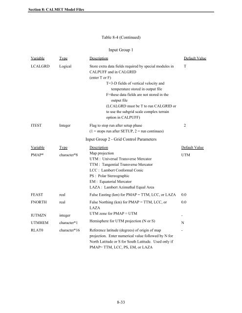
Section 8: CALMET Model Files Table 8-4 (Continued) Input Group 1 Variable Type Description Default Value LCALGRD Logical Store extra data fields required by special modules in CALPUFF and in CALGRID (enter T or F) T=3-D fields of vertical velocity and temperature stored in output file F=these data fields are not stored in the output file (LCALGRD must be T to run CALGRID or to use the subgrid scale complex terrain option in CALPUFF) ITEST Integer Flag to stop run after setup phase (1 = stops run after SETUP, 2 = run continues) T 2 Input Group 2 - Grid Control Parameters Variable Type Description Default Value PMAP* character*8 Map projection UTM UTM : Universal Transverse Mercator TTM : Tangential Transverse Mercator LCC : Lambert Conformal Conic PS : Polar Stereographic EM : Equatorial Mercator LAZA : Lambert Azimuthal Equal Area FEAST real False Easting (km) for PMAP = TTM, LCC, or LAZA 0.0 FNORTH real False Northing (km) for PMAP = TTM, LCC, or LAZA IUTMZN integer UTM zone for PMAP = UTM UTMHEM character*1 Hemisphere for UTM projection (N or S) RLAT0 character*16 Reference latitude (degrees) of origin of map projection. Enter numerical value followed by N for North Latitude or S for South Latitude. Used only if PMAP= TTM, LCC, PS, EM, or LAZA 0.0 - N - 8-33
Section 8: CALMET Model Files Table 8-4 (Continued) Input Group 1 Variable Type Description Default Value RLON0 character*16 Reference longitude (degrees) of origin of map projection. Enter numerical value followed by E for East Longitude or W for West Longitude. Used only if PMAP= TTM, LCC, PS, EM, or LAZA XLAT1 XLAT2 character*16 Latitudes (degrees) of the two matching parallels for map projection (Used only if PMAP= LCC or PS). Enter numerical value followed by N for North Latitude or S for South Latitude. - - DATUM character*8 DATUM Code for grid coordinates. WGS-G NX integer Number of grid cells in the X direction - NY integer Number of grid cells in the Y direction - Input Group 2 - Grid Control Parameters Variable Type Description Default Value DGRIDKM real Horizontal grid spacing (km) - XORIGKM real Reference X coordinate* (km) of the southwest corner of grid cell (1,1) YORIGKM real Reference Y coordinate* (km) of the southwest corner of grid cell (1,1) - - NZ integer Number of vertical layers - ZFACE real array Cell face heights (m). Note: Cell center height of layer "i" is (ZFACE(i+1) + ZFACE(i))/2. NZ+1 values must be entered. * PMAP projections PS, EM, and LAZA are NOT AVAILABLE in CALMET - Table 8-4 (Continued) Input Group 3 - Output Options Variable Type Description Default Value LSAVE logical Disk output control variable. If LSAVE=T, the gridded wind fields are stored in an output disk file (CALMET.DAT). T 8-34
- Page 247 and 248: Section 7: Prognostic Meteorologica
- Page 249 and 250: Section 7: Prognostic Meteorologica
- Page 251 and 252: Section 7: Prognostic Meteorologica
- Page 253 and 254: Section 7: Prognostic Meteorologica
- Page 255 and 256: Section 7: Prognostic Meteorologica
- Page 257 and 258: Section 7: Prognostic Meteorologica
- Page 259 and 260: Section 7: Prognostic Meteorologica
- Page 261 and 262: Section 7: Prognostic Meteorologica
- Page 263 and 264: Section 7: Prognostic Meteorologica
- Page 265 and 266: Section 7: Prognostic Meteorologica
- Page 267 and 268: Section 8: CALMET Model Files (e.g.
- Page 269 and 270: Section 8: CALMET Model Files Table
- Page 271 and 272: Section 8: CALMET Model Files descr
- Page 273 and 274: Section 8: CALMET Model Files Table
- Page 275 and 276: Section 8: CALMET Model Files Table
- Page 277 and 278: Section 8: CALMET Model Files Table
- Page 279 and 280: Section 8: CALMET Model Files Table
- Page 281 and 282: Section 8: CALMET Model Files Table
- Page 283 and 284: Section 8: CALMET Model Files Table
- Page 285 and 286: Section 8: CALMET Model Files Table
- Page 287 and 288: Section 8: CALMET Model Files Table
- Page 289 and 290: Section 8: CALMET Model Files Table
- Page 291 and 292: Section 8: CALMET Model Files Table
- Page 293 and 294: Section 8: CALMET Model Files Table
- Page 295 and 296: Section 8: CALMET Model Files Table
- Page 297: Section 8: CALMET Model Files Table
- Page 301 and 302: Section 8: CALMET Model Files Table
- Page 303 and 304: Section 8: CALMET Model Files Table
- Page 305 and 306: Section 8: CALMET Model Files Table
- Page 307 and 308: Section 8: CALMET Model Files Table
- Page 309 and 310: Section 8: CALMET Model Files Table
- Page 311 and 312: Section 8: CALMET Model Files Table
- Page 313 and 314: Section 8: CALMET Model Files Table
- Page 315 and 316: Section 8: CALMET Model Files Table
- Page 317 and 318: Section 8: CALMET Model Files Table
- Page 319 and 320: Section 8: CALMET Model Files Table
- Page 321 and 322: Section 8: CALMET Model Files range
- Page 323 and 324: Section 8: CALMET Model Files Table
- Page 325 and 326: Section 8: CALMET Model Files Table
- Page 327 and 328: Section 8: CALMET Model Files Table
- Page 329 and 330: Section 8: CALMET Model Files Table
- Page 331 and 332: Section 8: CALMET Model Files Table
- Page 333 and 334: Section 8: CALMET Model Files Table
- Page 335 and 336: Section 8: CALMET Model Files Table
- Page 337 and 338: Section 8: CALMET Model Files Table
- Page 339 and 340: Section 8: CALMET Model Files Table
- Page 341 and 342: Section 8: CALMET Model Files Table
- Page 343 and 344: Section 8: CALMET Model Files Table
- Page 345 and 346: Section 8: CALMET Model Files Table
- Page 347 and 348: Section 8: CALMET Model Files Table
Section 8: CALMET Model Files<br />
<strong>Table</strong> 8-4 (Continued)<br />
Input <strong>Group</strong> 1<br />
Variable Type Description Default Value<br />
LCALGRD Logical Store extra d<strong>at</strong>a fields required by special modules in<br />
CALPUFF and in CALGRID<br />
(enter T or F)<br />
T=3-D fields <strong>of</strong> vertical velocity and<br />
temper<strong>at</strong>ure stored in output file<br />
F=these d<strong>at</strong>a fields are not stored in the<br />
output file<br />
(LCALGRD must be T to run CALGRID or<br />
to use the subgrid scale complex terrain<br />
option in CALPUFF)<br />
ITEST Integer Flag to stop run after setup phase<br />
(1 = stops run after SETUP, 2 = run continues)<br />
T<br />
2<br />
Input <strong>Group</strong> 2 - Grid Control Parameters<br />
Variable Type Description Default Value<br />
PMAP* character*8<br />
Map projection<br />
UTM<br />
UTM : Universal Transverse Merc<strong>at</strong>or<br />
TTM : Tangential Transverse Merc<strong>at</strong>or<br />
LCC : Lambert Conformal Conic<br />
PS : Polar Stereographic<br />
EM : Equ<strong>at</strong>orial Merc<strong>at</strong>or<br />
LAZA : Lambert Azimuthal Equal Area<br />
FEAST real False Easting (km) for PMAP = TTM, LCC, or LAZA 0.0<br />
FNORTH real False Northing (km) for PMAP = TTM, LCC, or<br />
LAZA<br />
IUTMZN integer<br />
UTM zone for PMAP = UTM<br />
UTMHEM character*1<br />
Hemisphere for UTM projection (N or S)<br />
RLAT0 character*16 Reference l<strong>at</strong>itude (degrees) <strong>of</strong> origin <strong>of</strong> map<br />
projection. Enter numerical value followed by N for<br />
North L<strong>at</strong>itude or S for South L<strong>at</strong>itude. Used only if<br />
PMAP= TTM, LCC, PS, EM, or LAZA<br />
0.0<br />
-<br />
N<br />
-<br />
8-33


