Table of Contents - The Atmospheric Studies Group at TRC
Table of Contents - The Atmospheric Studies Group at TRC Table of Contents - The Atmospheric Studies Group at TRC
Section 2: Geophysical Data Processors (IWAT2) Default: 55 ! IWAT2 = 55 ! !END! ------------- Subgroup (3b) ------------- a OUTPUT LAND USE CATEGORIES (NOUTCAT entries) -------------------------------------------- ! OUTCAT = 10, 20, -20, 30, 40, 51, 54, 55 ! !END! ! OUTCAT = 60, 61, 62, 70, 80, 90 ! !END! ------------- a List categories in ascending order (absolute value), with up to 10 per line. Each line is treated as a separate input subgroup and therefore must end with an input group terminator. -------------------------------------------------------------------------------- INPUT GROUP: 4 -- Input Land Use (Defaults are set for USGS categories) -------------- ------------- Subgroup (4a) ------------- Number of input land use categories (NINCAT) Default: 38 ! NINCAT = 38 ! Number of input water categories (NUMWAT) Default: 5 ! NUMWAT = 5 ! Number of input categories that are split by apportioning area among the other land use categories Table 2-14 (continued) Sample MAKEGEO Control File (MAKEGEO.INP) (NSPLIT) Default: 0 ! NSPLIT = 0 ! Minimum fraction of cell covered by water required to define the dominant land use as water (CFRACT) Default: 0.5 ! CFRACT = 0.5 ! Land use category assigned to cell when no land use data are found (IMISS) Default: 55 ! IMISS = 55 ! Minimum total fractional land use expected 2-57
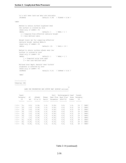
Section 2: Geophysical Data Processors in a cell when land use data are available (FLUMIN) Default: 0.96 ! FLUMIN = 0.96 ! !END! Method to obtain surface roughness when the surface is covered by snow (Used only if LSNOW = T) (MSRL) Default: 1 ! MSRL = 1 ! 1 = Computed from effective obstacle height 2 = User-defined table Height Scale (m) for computing effective obstacle height (method MSRL=1) (Used only if LSNOW = T) (HSCL) Default: 10. ! HSCL = 10 ! Method to obtain surface albedo when the surface is covered by snow (Used only if LSNOW = T) (MSAL) Default: 1 ! MSAL = 1 ! 1 = Computed using snow ages 2 = Use user-defined table Minimum snow depth (meters) when surface roughness is affected by snow (Used only if LSNOW = T) (SDPMIN) Default: 0.01 ! SDPMIN = 0.01 ! !END! ------------- Subgroup (4b) ------------- a LAND USE PROPERTIES AND OUTPUT MAP (NINCAT entries) --------------------------------------------------- Input Soil Anthropogenic Leaf Output Category z0 Albedo Bowen Heat Flux Heat Flux Area Category ID (m) (0 to 1) Ratio Parameter (W/m**2) Index ID ------ ------ ------ ------ --------- -------- ------ ------ ! X = 11, 0.5, 0.18, 1.0, 0.20, 0.0, 1.0, 10 ! !END! ! X = 12, 1.0, 0.18, 1.5, 0.25, 0.0, 0.2, 10 ! !END! ! X = 13, 1.0, 0.18, 1.5, 0.25, 0.0, 0.2, 10 ! !END! ! X = 14, 1.0, 0.18, 1.5, 0.25, 0.0, 0.2, 10 ! !END! ! X = 15, 1.0, 0.18, 1.5, 0.25, 0.0, 0.2, 10 ! !END! ! X = 16, 1.0, 0.18, 1.5, 0.25, 0.0, 0.2, 10 ! !END! ! X = 17, 1.0, 0.18, 1.5, 0.25, 0.0, 0.2, 10 ! !END! ! X = 21, 0.25, 0.15, 1.0, 0.15, 0.0, 3.0, 20 ! !END! ! X = 22, 0.25, 0.15, 1.0, 0.15, 0.0, 3.0, 20 ! !END! ! X = 23, 0.25, 0.15, 1.0, 0.15, 0.0, 3.0, 20 ! !END! Table 2-14 (continued) 2-58
- Page 63 and 64: Section 2: Geophysical Data Process
- Page 65 and 66: Section 2: Geophysical Data Process
- Page 67 and 68: Section 2: Geophysical Data Process
- Page 69 and 70: Section 2: Geophysical Data Process
- Page 71 and 72: Section 2: Geophysical Data Process
- Page 73 and 74: Section 2: Geophysical Data Process
- Page 75 and 76: Section 2: Geophysical Data Process
- Page 77 and 78: Section 2: Geophysical Data Process
- Page 79 and 80: Section 2: Geophysical Data Process
- Page 81 and 82: Section 2: Geophysical Data Process
- Page 83 and 84: Section 2: Geophysical Data Process
- Page 85 and 86: Section 2: Geophysical Data Process
- Page 87 and 88: Section 2: Geophysical Data Process
- Page 89 and 90: Section 2: Geophysical Data Process
- Page 91 and 92: Section 2: Geophysical Data Process
- Page 93 and 94: Section 2: Geophysical Data Process
- Page 95 and 96: Section 2: Geophysical Data Process
- Page 97 and 98: Section 2: Geophysical Data Process
- Page 99 and 100: Section 2: Geophysical Data Process
- Page 101 and 102: Section 2: Geophysical Data Process
- Page 103 and 104: Section 2: Geophysical Data Process
- Page 105 and 106: Section 2: Geophysical Data Process
- Page 107 and 108: Section 2: Geophysical Data Process
- Page 109 and 110: Section 2: Geophysical Data Process
- Page 111 and 112: Section 2: Geophysical Data Process
- Page 113: Section 2: Geophysical Data Process
- Page 117 and 118: Section 2: Geophysical Data Process
- Page 119 and 120: Section 2: Geophysical Data Process
- Page 121 and 122: Section 2: Geophysical Data Process
- Page 123 and 124: Section 2: Geophysical Data Process
- Page 125 and 126: Section 2: Geophysical Data Process
- Page 127 and 128: Section 3: READ62 Upper Air Preproc
- Page 129 and 130: Section 3: READ62 Upper Air Preproc
- Page 131 and 132: Section 3: READ62 Upper Air Preproc
- Page 133 and 134: Section 3: READ62 Upper Air Preproc
- Page 135 and 136: Section 3: READ62 Upper Air Preproc
- Page 137 and 138: Section 3: READ62 Upper Air Preproc
- Page 139 and 140: Section 3: READ62 Upper Air Preproc
- Page 141 and 142: Section 4: PXTRACT Precipitation Da
- Page 143 and 144: Section 4: PXTRACT Precipitation Da
- Page 145 and 146: Section 4: PXTRACT Precipitation Da
- Page 147 and 148: Section 4: PXTRACT Precipitation Da
- Page 149 and 150: Section 4: PXTRACT Precipitation Da
- Page 151 and 152: Section 5: PMERGE Precipitation Dat
- Page 153 and 154: Section 5: PMERGE Precipitation Dat
- Page 155 and 156: Section 5: PMERGE Precipitation Dat
- Page 157 and 158: Section 5: PMERGE Precipitation Dat
- Page 159 and 160: Section 5: PMERGE Precipitation Dat
- Page 161 and 162: Section 5: PMERGE Precipitation Dat
- Page 163 and 164: Section 5: PMERGE Precipitation Dat
Section 2: Geophysical D<strong>at</strong>a Processors<br />
in a cell when land use d<strong>at</strong>a are available<br />
(FLUMIN) Default: 0.96 ! FLUMIN = 0.96 !<br />
!END!<br />
Method to obtain surface roughness when<br />
the surface is covered by snow<br />
(Used only if LSNOW = T)<br />
(MSRL) Default: 1 ! MSRL = 1 !<br />
1 = Computed from effective obstacle height<br />
2 = User-defined table<br />
Height Scale (m) for computing effective<br />
obstacle height (method MSRL=1)<br />
(Used only if LSNOW = T)<br />
(HSCL) Default: 10. ! HSCL = 10 !<br />
Method to obtain surface albedo when the<br />
surface is covered by snow<br />
(Used only if LSNOW = T)<br />
(MSAL) Default: 1 ! MSAL = 1 !<br />
1 = Computed using snow ages<br />
2 = Use user-defined table<br />
Minimum snow depth (meters) when surface<br />
roughness is affected by snow<br />
(Used only if LSNOW = T)<br />
(SDPMIN) Default: 0.01 ! SDPMIN = 0.01 !<br />
!END!<br />
-------------<br />
Subgroup (4b)<br />
-------------<br />
a<br />
LAND USE PROPERTIES AND OUTPUT MAP (NINCAT entries)<br />
---------------------------------------------------<br />
Input Soil Anthropogenic Leaf Output<br />
C<strong>at</strong>egory z0 Albedo Bowen He<strong>at</strong> Flux He<strong>at</strong> Flux Area C<strong>at</strong>egory<br />
ID (m) (0 to 1) R<strong>at</strong>io Parameter (W/m**2) Index ID<br />
------ ------ ------ ------ --------- -------- ------ ------<br />
! X = 11, 0.5, 0.18, 1.0, 0.20, 0.0, 1.0, 10 ! !END!<br />
! X = 12, 1.0, 0.18, 1.5, 0.25, 0.0, 0.2, 10 ! !END!<br />
! X = 13, 1.0, 0.18, 1.5, 0.25, 0.0, 0.2, 10 ! !END!<br />
! X = 14, 1.0, 0.18, 1.5, 0.25, 0.0, 0.2, 10 ! !END!<br />
! X = 15, 1.0, 0.18, 1.5, 0.25, 0.0, 0.2, 10 ! !END!<br />
! X = 16, 1.0, 0.18, 1.5, 0.25, 0.0, 0.2, 10 ! !END!<br />
! X = 17, 1.0, 0.18, 1.5, 0.25, 0.0, 0.2, 10 ! !END!<br />
! X = 21, 0.25, 0.15, 1.0, 0.15, 0.0, 3.0, 20 ! !END!<br />
! X = 22, 0.25, 0.15, 1.0, 0.15, 0.0, 3.0, 20 ! !END!<br />
! X = 23, 0.25, 0.15, 1.0, 0.15, 0.0, 3.0, 20 ! !END!<br />
<strong>Table</strong> 2-14 (continued)<br />
2-58


