Table of Contents - The Atmospheric Studies Group at TRC
Table of Contents - The Atmospheric Studies Group at TRC Table of Contents - The Atmospheric Studies Group at TRC
Section 2: Geophysical Data Processors Read in a second fractional land use file (LLU2) Default: F ! LLU2 = F ! T = supplemental fractional land use read from LU2.DAT F = no supplemental fractional land use data are available 2-53
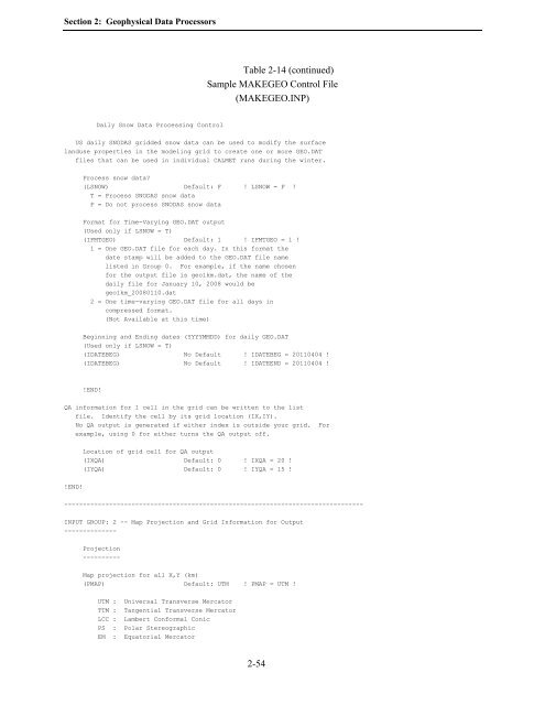
Section 2: Geophysical Data Processors Table 2-14 (continued) Sample MAKEGEO Control File (MAKEGEO.INP) Daily Snow Data Processing Control US daily SNODAS gridded snow data can be used to modify the surface landuse properties in the modeling grid to create one or more GEO.DAT files that can be used in individual CALMET runs during the winter. Process snow data (LSNOW) Default: F ! LSNOW = F ! T = Process SNODAS snow data F = Do not process SNODAS snow data Format for Time-Varying GEO.DAT output (Used only if LSNOW = T) (IFMTGEO) Default: 1 ! IFMTGEO = 1 ! 1 = One GEO.DAT file for each day. In this format the date stamp will be added to the GEO.DAT file name listed in Group 0. For example, if the name chosen for the output file is geo1km.dat, the name of the daily file for January 10, 2008 would be geo1km_20080110.dat 2 = One time-varying GEO.DAT file for all days in compressed format. (Not Available at this time) Beginning and Ending dates (YYYYMMDD) for daily GEO.DAT (Used only if LSNOW = T) (IDATEBEG) No Default ! IDATEBEG = 20110404 ! (IDATEBEG) No Default ! IDATEEND = 20110404 ! !END! QA information for 1 cell in the grid can be written to the list file. Identify the cell by its grid location (IX,IY). No QA output is generated if either index is outside your grid. For example, using 0 for either turns the QA output off. Location of grid cell for QA output (IXQA) Default: 0 ! IXQA = 20 ! (IYQA) Default: 0 ! IYQA = 15 ! !END! -------------------------------------------------------------------------------- INPUT GROUP: 2 -- Map Projection and Grid Information for Output -------------- Projection ---------- Map projection for all X,Y (km) (PMAP) Default: UTM ! PMAP = UTM ! UTM : Universal Transverse Mercator TTM : Tangential Transverse Mercator LCC : Lambert Conformal Conic PS : Polar Stereographic EM : Equatorial Mercator 2-54
- Page 59 and 60: Section 2: Geophysical Data Process
- Page 61 and 62: Section 2: Geophysical Data Process
- Page 63 and 64: Section 2: Geophysical Data Process
- Page 65 and 66: Section 2: Geophysical Data Process
- Page 67 and 68: Section 2: Geophysical Data Process
- Page 69 and 70: Section 2: Geophysical Data Process
- Page 71 and 72: Section 2: Geophysical Data Process
- Page 73 and 74: Section 2: Geophysical Data Process
- Page 75 and 76: Section 2: Geophysical Data Process
- Page 77 and 78: Section 2: Geophysical Data Process
- Page 79 and 80: Section 2: Geophysical Data Process
- Page 81 and 82: Section 2: Geophysical Data Process
- Page 83 and 84: Section 2: Geophysical Data Process
- Page 85 and 86: Section 2: Geophysical Data Process
- Page 87 and 88: Section 2: Geophysical Data Process
- Page 89 and 90: Section 2: Geophysical Data Process
- Page 91 and 92: Section 2: Geophysical Data Process
- Page 93 and 94: Section 2: Geophysical Data Process
- Page 95 and 96: Section 2: Geophysical Data Process
- Page 97 and 98: Section 2: Geophysical Data Process
- Page 99 and 100: Section 2: Geophysical Data Process
- Page 101 and 102: Section 2: Geophysical Data Process
- Page 103 and 104: Section 2: Geophysical Data Process
- Page 105 and 106: Section 2: Geophysical Data Process
- Page 107 and 108: Section 2: Geophysical Data Process
- Page 109: Section 2: Geophysical Data Process
- Page 113 and 114: Section 2: Geophysical Data Process
- Page 115 and 116: Section 2: Geophysical Data Process
- Page 117 and 118: Section 2: Geophysical Data Process
- Page 119 and 120: Section 2: Geophysical Data Process
- Page 121 and 122: Section 2: Geophysical Data Process
- Page 123 and 124: Section 2: Geophysical Data Process
- Page 125 and 126: Section 2: Geophysical Data Process
- Page 127 and 128: Section 3: READ62 Upper Air Preproc
- Page 129 and 130: Section 3: READ62 Upper Air Preproc
- Page 131 and 132: Section 3: READ62 Upper Air Preproc
- Page 133 and 134: Section 3: READ62 Upper Air Preproc
- Page 135 and 136: Section 3: READ62 Upper Air Preproc
- Page 137 and 138: Section 3: READ62 Upper Air Preproc
- Page 139 and 140: Section 3: READ62 Upper Air Preproc
- Page 141 and 142: Section 4: PXTRACT Precipitation Da
- Page 143 and 144: Section 4: PXTRACT Precipitation Da
- Page 145 and 146: Section 4: PXTRACT Precipitation Da
- Page 147 and 148: Section 4: PXTRACT Precipitation Da
- Page 149 and 150: Section 4: PXTRACT Precipitation Da
- Page 151 and 152: Section 5: PMERGE Precipitation Dat
- Page 153 and 154: Section 5: PMERGE Precipitation Dat
- Page 155 and 156: Section 5: PMERGE Precipitation Dat
- Page 157 and 158: Section 5: PMERGE Precipitation Dat
- Page 159 and 160: Section 5: PMERGE Precipitation Dat
Section 2: Geophysical D<strong>at</strong>a Processors<br />
<strong>Table</strong> 2-14 (continued)<br />
Sample MAKEGEO Control File<br />
(MAKEGEO.INP)<br />
Daily Snow D<strong>at</strong>a Processing Control<br />
US daily SNODAS gridded snow d<strong>at</strong>a can be used to modify the surface<br />
landuse properties in the modeling grid to cre<strong>at</strong>e one or more GEO.DAT<br />
files th<strong>at</strong> can be used in individual CALMET runs during the winter.<br />
Process snow d<strong>at</strong>a<br />
(LSNOW) Default: F ! LSNOW = F !<br />
T = Process SNODAS snow d<strong>at</strong>a<br />
F = Do not process SNODAS snow d<strong>at</strong>a<br />
Form<strong>at</strong> for Time-Varying GEO.DAT output<br />
(Used only if LSNOW = T)<br />
(IFMTGEO) Default: 1 ! IFMTGEO = 1 !<br />
1 = One GEO.DAT file for each day. In this form<strong>at</strong> the<br />
d<strong>at</strong>e stamp will be added to the GEO.DAT file name<br />
listed in <strong>Group</strong> 0. For example, if the name chosen<br />
for the output file is geo1km.d<strong>at</strong>, the name <strong>of</strong> the<br />
daily file for January 10, 2008 would be<br />
geo1km_20080110.d<strong>at</strong><br />
2 = One time-varying GEO.DAT file for all days in<br />
compressed form<strong>at</strong>.<br />
(Not Available <strong>at</strong> this time)<br />
Beginning and Ending d<strong>at</strong>es (YYYYMMDD) for daily GEO.DAT<br />
(Used only if LSNOW = T)<br />
(IDATEBEG) No Default ! IDATEBEG = 20110404 !<br />
(IDATEBEG) No Default ! IDATEEND = 20110404 !<br />
!END!<br />
QA inform<strong>at</strong>ion for 1 cell in the grid can be written to the list<br />
file. Identify the cell by its grid loc<strong>at</strong>ion (IX,IY).<br />
No QA output is gener<strong>at</strong>ed if either index is outside your grid. For<br />
example, using 0 for either turns the QA output <strong>of</strong>f.<br />
Loc<strong>at</strong>ion <strong>of</strong> grid cell for QA output<br />
(IXQA) Default: 0 ! IXQA = 20 !<br />
(IYQA) Default: 0 ! IYQA = 15 !<br />
!END!<br />
--------------------------------------------------------------------------------<br />
INPUT GROUP: 2 -- Map Projection and Grid Inform<strong>at</strong>ion for Output<br />
--------------<br />
Projection<br />
----------<br />
Map projection for all X,Y (km)<br />
(PMAP) Default: UTM ! PMAP = UTM !<br />
UTM : Universal Transverse Merc<strong>at</strong>or<br />
TTM : Tangential Transverse Merc<strong>at</strong>or<br />
LCC : Lambert Conformal Conic<br />
PS : Polar Stereographic<br />
EM : Equ<strong>at</strong>orial Merc<strong>at</strong>or<br />
2-54


