downloaded - The Atmospheric Studies Group at TRC
downloaded - The Atmospheric Studies Group at TRC
downloaded - The Atmospheric Studies Group at TRC

You also want an ePaper? Increase the reach of your titles
YUMPU automatically turns print PDFs into web optimized ePapers that Google loves.
Development of the Next<br />
Gener<strong>at</strong>ion Air Quality<br />
Models for Outer Continental<br />
Shelf (OCS) Applic<strong>at</strong>ions<br />
Final Report: Volume 2 -<br />
CALPUFF Users Guide<br />
(CALMET and Preprocessors)<br />
March 2006<br />
Prepared For:<br />
U.S. Department of the Interior,<br />
Minerals Management Service, Herndon, VA<br />
Contract No.<br />
1435-01-01-CT-31071<br />
Prepared By:<br />
Earth Tech, Inc.<br />
196 Baker Avenue<br />
Concord, Massachusetts 01742<br />
(978) 371-4000
Contents<br />
A. OVERVIEW A-1<br />
A.1 Background A-1<br />
A.2 Overview of the Modeling System A-4<br />
A.3 Major Model Algorithms and Options A-14<br />
A.4 Summary of D<strong>at</strong>a and Computer Requirements A-23<br />
B. GEOPHYSICAL DATA PROCESSORS B-1<br />
B.1 TERREL Terrain Preprocessor B-3<br />
B.2 Land Use D<strong>at</strong>a Preprocessors (CTGCOMP and CTGPROC) B-17<br />
B.3 MAKEGEO B-31<br />
B.4 NIMA DATUM REFERENCE INFORMATION B-42<br />
C. METEOROLOGICAL DATA PROCESSORS C-1<br />
C.1 READ62 UPPER AIR PREPROCESSOR C-1<br />
C.2 PXTRACT PRECIPITATION DATA EXTRACT PROGRAM C-12<br />
C.3 PMERGE PRECIPITATION DATA PREPROCESSOR C-19<br />
C.4 SMERGE SURFACE DATA METEOROLOGICAL PREPROCESSOR C-29<br />
C.5 BUOY OVER-WATER DATA METEOROLOGICAL PREPROCESSOR C-39<br />
D. PROGNOSTIC METEOROLOGICAL DATA PROCESSORS D-1<br />
D.1 CALMM5 D-1<br />
D.2 CALETA D-25<br />
D.3 CALRUC D-40<br />
D.4 CALRAMS D-48<br />
D.5 3D.DAT OUTPUT FILE D-53<br />
E. CALMET MODEL FILES E-1<br />
E.1 User Control File (CALMET.INP) E-5<br />
E.2 Geophysical D<strong>at</strong>a File (GEO.DAT) E-49<br />
E.3 Upper Air D<strong>at</strong>a Files (UP1.DAT, UP2.DAT,...) E-61<br />
E.4 Surface Meteorological D<strong>at</strong>a File (SURF.DAT) E-66<br />
E.5 Overw<strong>at</strong>er D<strong>at</strong>a Files (SEA1.DAT, SEA2.DAT, ...) E-70<br />
E.6 Precipit<strong>at</strong>ion D<strong>at</strong>a File (PRECIP.DAT) E-74<br />
E.7 Preprocessed Diagnostic Model D<strong>at</strong>a File (DIAG.DAT) E-78<br />
E.8 Prognostic Model D<strong>at</strong>a File (PROG.DAT) E-82<br />
E.9 3D Model D<strong>at</strong>a Files (3D.DAT) E-84<br />
E.10 Terrain Weighting Factor D<strong>at</strong>a File (WT.DAT) E-102<br />
E.11 CALMET Output Files E-109<br />
Volume II & III References
A. OVERVIEW<br />
A.1 Background<br />
<strong>The</strong> purpose of this study is to develop an upd<strong>at</strong>ed regul<strong>at</strong>ory model for evalu<strong>at</strong>ing air quality impacts<br />
from emission sources loc<strong>at</strong>ed on federal w<strong>at</strong>ers of the Outer Continental Shelf (OCS). <strong>The</strong> United St<strong>at</strong>es<br />
Department of the Interior Minerals Management Service (MMS) is in charge of a n<strong>at</strong>ional program to<br />
develop the mineral resources, including oil and gas and altern<strong>at</strong>ive energy sources (such as wind power),<br />
on the OCS w<strong>at</strong>ers of the United St<strong>at</strong>es. <strong>The</strong> areas of development are loc<strong>at</strong>ed <strong>at</strong> distances ranging from 3<br />
miles to more than 100 miles from shore.<br />
In the early 1980s the MMS developed the Offshore & Coastal Dispersion (OCD) model (Hanna et al.,<br />
1985) to evalu<strong>at</strong>e impacts from the so-called “nonreactive” pollutants (NO 2 , SO 2 , CO, PM) emitted from<br />
point, line, or area sources loc<strong>at</strong>ed over w<strong>at</strong>er. Since then the science of dispersion modeling has made<br />
significant advances, as have the comput<strong>at</strong>ional and d<strong>at</strong>a resources th<strong>at</strong> support this modeling. <strong>The</strong>refore<br />
the focus of this study was to modify and/or enhance an existing model so th<strong>at</strong> it can be appropri<strong>at</strong>ely<br />
applied to overw<strong>at</strong>er transport and dispersion simul<strong>at</strong>ions using the most current knowledge, and is<br />
vers<strong>at</strong>ile enough to be used in short-range as well as long-range regul<strong>at</strong>ory applic<strong>at</strong>ions. <strong>The</strong> new model<br />
for OCS applic<strong>at</strong>ions is an upd<strong>at</strong>e to the CALPUFF (Scire et al., 2000a, 2000b) modeling system.<br />
<strong>The</strong> original design specific<strong>at</strong>ions for CALPUFF included: (1) the capability to tre<strong>at</strong> time-varying<br />
sources, (2) suitability for modeling domains from tens of meters to hundreds of kilometers from a<br />
source, (3) predictions for averaging times ranging from one-hour to one year, (4) applicability to inert<br />
pollutants and those subject to linear removal and chemical conversion mechanisms, and, (5) applicability<br />
for rough or complex terrain situ<strong>at</strong>ions. <strong>The</strong> modeling system developed to meet these objectives<br />
consisted of three components:<br />
• CALMET, a meteorological modeling package with both diagnostic and prognostic wind field<br />
gener<strong>at</strong>ors<br />
• CALPUFF, a Gaussian puff dispersion model with chemical removal, wet and dry deposition,<br />
complex terrain algorithms, building downwash, plume fumig<strong>at</strong>ion, and other effects<br />
• CALPOST and other postprocessing programs for the output fields of meteorological d<strong>at</strong>a,<br />
concentr<strong>at</strong>ions and deposition fluxes.<br />
CALMET, CALPUFF, and CALPOST have been substantially revised and enhanced over time, and the<br />
modeling system has achieved regul<strong>at</strong>ory st<strong>at</strong>us. <strong>The</strong> U.S. EPA has design<strong>at</strong>ed the CALPUFF modeling<br />
system as a Guideline ("Appendix A") model for regul<strong>at</strong>ory applic<strong>at</strong>ions involving long range transport,<br />
and on a case-by-case basis for near-field applic<strong>at</strong>ions where non-steady-st<strong>at</strong>e effects (situ<strong>at</strong>ions where<br />
factors such as sp<strong>at</strong>ial variability in the meteorological fields, calm winds, fumig<strong>at</strong>ion, recircul<strong>at</strong>ion or<br />
stagn<strong>at</strong>ion, and terrain or coastal effects) may be important.<br />
MAR 2006 –Overview<br />
A-1
In the early 1990s, the Interagency Workgroup on Air Quality Modeling (IWAQM) reviewed various<br />
modeling approaches suitable for estim<strong>at</strong>ing pollutant concentr<strong>at</strong>ions <strong>at</strong> Class I areas, including the<br />
individual and cumul<strong>at</strong>ive impacts of proposed and existing sources on Air Quality Rel<strong>at</strong>ed Values<br />
(AQRVs), Prevention of Significant Deterior<strong>at</strong>ion (PSD) increments, and N<strong>at</strong>ional Ambient Air Quality<br />
Standards (NAAQS). IWAQM consists of represent<strong>at</strong>ives from the U.S. Environmental Protection<br />
Agency (EPA), U.S. Forest Service, N<strong>at</strong>ional Park Service, and U.S. Fish and Wildlife Service. IWAQM<br />
released a Phase I report (EPA, 1993) which recommended using the MESOPUFF II dispersion model<br />
and MESOPAC II meteorological model on an interim basis for simul<strong>at</strong>ing regional air quality and<br />
visibility impacts. <strong>The</strong>se recommend<strong>at</strong>ions were to apply until more refined (Phase 2) techniques could<br />
be identified and evalu<strong>at</strong>ed. As part of the development of the Phase 2 recommend<strong>at</strong>ions, IWAQM<br />
reviewed and intercompared diagnostic wind field models, tested the use of coarse gridded wind fields<br />
from the Penn St<strong>at</strong>e/NCAR Mesoscale Model with four dimensional d<strong>at</strong>a assimil<strong>at</strong>ion (MM4) as input<br />
into the diagnostic models, and evalu<strong>at</strong>ed the MESOPUFF II and CALPUFF modeling systems using<br />
tracer d<strong>at</strong>a collected during the Cross-Appalachian Tracer Experiment (CAPTEX). <strong>The</strong> CAPTEX<br />
evalu<strong>at</strong>ion results (EPA, 1995) indic<strong>at</strong>ed th<strong>at</strong> by using the CALMET/ CALPUFF models with MM4 d<strong>at</strong>a,<br />
performance could be improved over th<strong>at</strong> obtained with the interim Phase I modeling approach. <strong>The</strong><br />
Phase 2 IWAQM report (EPA, 1998) recommends the use of the CALMET and CALPUFF models for<br />
estim<strong>at</strong>ing air quality impacts rel<strong>at</strong>ive to the N<strong>at</strong>ional Ambient Air Quality Standards (NAAQS) and<br />
Prevention of Significant Deterior<strong>at</strong>ion (PSD) increments.<br />
Changes to the system th<strong>at</strong> were designed and implemented for OCS applic<strong>at</strong>ions include ease-of-use<br />
fe<strong>at</strong>ures as well as new and modified subroutines in both the CALMET meteorological model and the<br />
CALPUFF dispersion model:<br />
• CALMET Upd<strong>at</strong>es<br />
o An option is provided to use the COARE (Coupled Ocean Atmosphere Response<br />
Experiment) overw<strong>at</strong>er flux model, Version 2.6bw, with or without wave d<strong>at</strong>a.<br />
o A convective (r<strong>at</strong>her than mechanical) overw<strong>at</strong>er boundary layer height is computed for<br />
L
o An option is provided to include an adjustment for turbulence advection from regions of<br />
larger turbulence velocity into regions of smaller turbulence velocity. This adjustment is<br />
applied to computed (not measured) turbulence.<br />
o <strong>The</strong> minimum l<strong>at</strong>eral turbulence velocity (σ v ) allowed is partitioned to distinguish values<br />
appropri<strong>at</strong>e for over-land cells and over-w<strong>at</strong>er cells.<br />
• BUOY processor<br />
o This new processor cre<strong>at</strong>es revised SEA.DAT files for CALMET with wave d<strong>at</strong>a for the<br />
COARE overw<strong>at</strong>er flux option.<br />
o D<strong>at</strong>a files readily obtained from NODC and NDBC web sites are read.<br />
• Graphical user interface (GUI) upd<strong>at</strong>es<br />
o <strong>The</strong> CALPRO system for geophysical and meteorological preprocessors and CALPOST<br />
and PRTMET postprocessors was extensively revised and enhanced.<br />
o A GUI for the BUOY processor was developed and integr<strong>at</strong>ed into CALPRO.<br />
o A GUI option was added to CALPRO for extracting a subset from the surface<br />
meteorological d<strong>at</strong>a, precipit<strong>at</strong>ion d<strong>at</strong>a, and ozone d<strong>at</strong>a from the Gulf of Mexico d<strong>at</strong>aset<br />
for a user’s CALMET domain.<br />
o <strong>The</strong> CALVIEW display system for meteorological fields and concentr<strong>at</strong>ion/deposition<br />
fields using the SURFER® contouring package was extensively revised and enhanced.<br />
• Standard Gulf of Mexico Meteorology and Ozone D<strong>at</strong>aset<br />
o Meteorological, geophysical and ozone d<strong>at</strong>a required for CALMET/CALPUFF<br />
simul<strong>at</strong>ions within the MMS Gulf of Mexico region were prepared for year 2003.<br />
o USGS terrain elev<strong>at</strong>ion files with 90m resolution and USGS land use d<strong>at</strong>a files with<br />
200m resolution were assembled for the domain.<br />
o Buoy st<strong>at</strong>ions in the domain were processed into 13 SEA.DAT files (1 st<strong>at</strong>ion/file).<br />
o Upper-air st<strong>at</strong>ions in the domain were processed into 21 UP.DAT files (1 st<strong>at</strong>ion/file).<br />
o 230 NWS hourly surface meteorological st<strong>at</strong>ions in the domain were processed into the<br />
SURF.DAT file.<br />
o 271 NWS precipit<strong>at</strong>ion st<strong>at</strong>ions in the domain were processed into the PRECIP.DAT file.<br />
o 201 ozone d<strong>at</strong>a st<strong>at</strong>ions in the domain were processed into the OZONE.DAT file.<br />
o One full year (2003) of gridded prognostic meteorological output fields from the Rapid<br />
Upd<strong>at</strong>e Cycle (RUC) mesoscale we<strong>at</strong>her model were reform<strong>at</strong>ted into 50 tiles (90 RUC<br />
grid-points/tile), for the portion of the 20km RUC grid th<strong>at</strong> covers the MMS Gulf of<br />
Mexico domain.<br />
o <strong>The</strong> RUCDECODE program was cre<strong>at</strong>ed to assemble RUC grid cell d<strong>at</strong>a from one or<br />
more tiles into a 3D.DAT file for a user’s CALMET domain.<br />
<strong>The</strong> technical formul<strong>at</strong>ion for CALMET is provided in Section 2 of Scire et al., 2000a and the technical<br />
formul<strong>at</strong>ion CALPUFF is provided in Section 2 of Scire et al., 2000b. Formul<strong>at</strong>ions for the upd<strong>at</strong>es to<br />
CALMET and CALPUFF are provided in Section 3 in Volume I of this report. Volumes II and III of this<br />
report contain applic<strong>at</strong>ion details for the following core system components:<br />
(Volume II)<br />
• Geophysical D<strong>at</strong>a Processors<br />
• Meteorological D<strong>at</strong>a Processors<br />
• Prognostic Meteorological Model Processors<br />
• CALMET<br />
MAR 2006 –Overview<br />
A-3
(Volume III)<br />
• CALPUFF<br />
• Postprocessors<br />
Linkages between programs are identified and the content of input and output files are provided. All of<br />
these programs can be used without the aid of the GUIs, but most can be accessed and configured using<br />
the GUI system.<br />
A.2 Overview of the Modeling System<br />
<strong>The</strong> CALPUFF Modeling System includes three main components: CALMET, CALPUFF, and<br />
CALPOST and a large set of preprocessing programs designed to interface the model to standard,<br />
routinely-available meteorological and geophysical d<strong>at</strong>asets. In the simplest terms, CALMET is a<br />
meteorological model th<strong>at</strong> develops hourly wind and temper<strong>at</strong>ure fields on a three-dimensional gridded<br />
modeling domain. Associ<strong>at</strong>ed two-dimensional fields such as mixing height, surface characteristics, and<br />
dispersion properties are also included in the file produced by CALMET. CALPUFF is a transport and<br />
dispersion model th<strong>at</strong> advects “puffs” of m<strong>at</strong>erial emitted from modeled sources, simul<strong>at</strong>ing dispersion<br />
and transform<strong>at</strong>ion processes along the way. In doing so it typically uses the fields gener<strong>at</strong>ed by<br />
CALMET, or as an option, it may use simpler non-gridded meteorological d<strong>at</strong>a much like existing plume<br />
models. Temporal and sp<strong>at</strong>ial vari<strong>at</strong>ions in the meteorological fields selected are explicitly incorpor<strong>at</strong>ed<br />
in the resulting distribution of puffs throughout a simul<strong>at</strong>ion period. <strong>The</strong> primary output files from<br />
CALPUFF contain either hourly concentr<strong>at</strong>ions or hourly deposition fluxes evalu<strong>at</strong>ed <strong>at</strong> selected receptor<br />
loc<strong>at</strong>ions. CALPOST is used to process these files, producing tabul<strong>at</strong>ions th<strong>at</strong> summarize the results of<br />
the simul<strong>at</strong>ion, identifying the highest and second highest 1-hour and 3-hour average concentr<strong>at</strong>ions <strong>at</strong><br />
each receptor, for example. When performing visibility-rel<strong>at</strong>ed modeling, CALPOST uses concentr<strong>at</strong>ions<br />
from CALPUFF to compute extinction coefficients and rel<strong>at</strong>ed measures of visibility, reporting these for<br />
selected averaging times and loc<strong>at</strong>ions.<br />
To enhance the functionality of the modeling system, a PC-based GUI is provided for nearly every<br />
component. <strong>The</strong> GUIs can be used to prepare the control file th<strong>at</strong> configures a run, execute the<br />
corresponding component model, and conduct file management functions. <strong>The</strong> GUIs also contain an<br />
extensive help system th<strong>at</strong> makes much of the technical inform<strong>at</strong>ion contained in this manual available to<br />
the user on-line. <strong>The</strong> modeling system may also be setup and run without the aid of the GUIs. <strong>The</strong><br />
control file for each component is simply a text file th<strong>at</strong> is readily edited, and it contains extensive<br />
inform<strong>at</strong>ion about model options, default values, and units for each variable.<br />
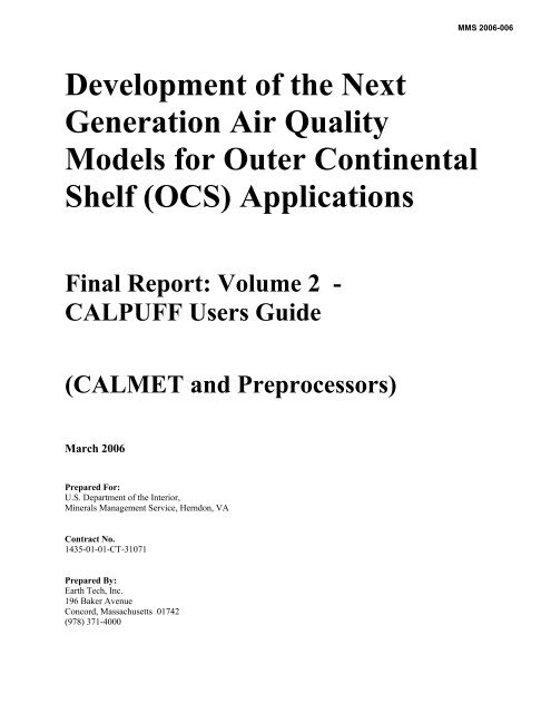
In addition to CALMET, CALPUFF, CALPOST, the modeling system interfaces to several other models,<br />
which is facilit<strong>at</strong>ed by several preprocessors and utilities. Figure A-1 displays the overall modeling<br />
system configur<strong>at</strong>ion. Two of the models plus the mesoscale meteorological models referenced in Figure<br />
MAR 2006 –Overview<br />
A-4
Meteorological &<br />
Geophysical D<strong>at</strong>a<br />
Preprocessors<br />
Meteorological Modeling<br />
Mesoscale<br />
Meteorological<br />
Models<br />
CALMET<br />
Meteorological<br />
Model<br />
Dispersion Modeling<br />
KSP<br />
Particle M odel<br />
CALPUFF<br />
Dispersion Model<br />
CALGRID<br />
Photochemical<br />
Model<br />
Postprocessing<br />
PRTMET<br />
Postprocessor<br />
POSTUTIL<br />
Postprocessor<br />
CALPOST<br />
Postprocessor<br />
Utility Programs<br />
APPEND, CALSUM<br />
A-1 are external models th<strong>at</strong> are not included in the CALPUFF system, but they can be interfaced with<br />
CALPUFF modules:<br />
Figure A-1.<br />
Overview of the program elements in the CALMET/CALPUFF modeling system. Also<br />
shown are the associ<strong>at</strong>ed CALGRID photochemical model, the KSP particle model, and<br />
mesoscale meteorological models th<strong>at</strong> may include MM5/MM4, NAM(Eta), WRF, RUC,<br />
RAMS, and CSUMM.<br />
MAR 2006 –Overview<br />
A-5
MM5/MM4 (Penn St<strong>at</strong>e/NCAR Mesoscale Model) is a prognostic wind field model with fourdimensional<br />
d<strong>at</strong>a assimil<strong>at</strong>ion. <strong>The</strong> interface program CALMM5 converts the MM5 output d<strong>at</strong>a<br />
into a form comp<strong>at</strong>ible with CALMET.<br />
NAM(formerly Eta) (North American Mesoscale model), and the WRF (We<strong>at</strong>her Research and<br />
Forecasting) model are NCEP oper<strong>at</strong>ional we<strong>at</strong>her models. Eta/NAM/WRF model output files<br />
are produced for use by the Advanced We<strong>at</strong>her Interactive Processing System (AWIPS) in<br />
various AWIPS grids. <strong>The</strong> interface program CALETA converts the NAM and WRF output d<strong>at</strong>a<br />
into a form comp<strong>at</strong>ible with CALMET.<br />
RUC (Rapid Upd<strong>at</strong>e Cycle) model is an NCEP oper<strong>at</strong>ional we<strong>at</strong>her model with high-frequency<br />
(every hour) short-range we<strong>at</strong>her model forecasts (out to 12+ hours). <strong>The</strong> interface program<br />
CALRUC converts the RUC output d<strong>at</strong>a into a form comp<strong>at</strong>ible with CALMET.<br />
RAMS (Regional <strong>Atmospheric</strong> Modeling System, Version 4.3) model is a NOAA Air Resources<br />
Labor<strong>at</strong>ory (ARL) numerical we<strong>at</strong>her model th<strong>at</strong> can be run <strong>at</strong> global, mesoscale, and local<br />
scales. <strong>The</strong> interface program CALRAMS converts the RAMS output d<strong>at</strong>a into a form<br />
comp<strong>at</strong>ible with CALMET.<br />
CSUMM (a version of the Colorado St<strong>at</strong>e University Mesoscale Model) is a primitive equ<strong>at</strong>ion<br />
wind field model th<strong>at</strong> simul<strong>at</strong>es mesoscale airflow resulting from differential surface he<strong>at</strong>ing and<br />
terrain effects. Various options for using CSUMM output with CALMET are provided.<br />
CALGRID is an Eulerian photochemical transport and dispersion model which includes modules<br />
for horizontal and vertical advection/diffusion, dry deposition, and a detailed photochemical<br />
mechanism (Yamartino et al., 1989, 1992). <strong>The</strong> output from CALMET may be used in<br />
CALGRID.<br />
KSP is a multi-layer, multi-species Lagrangian particle model th<strong>at</strong> simul<strong>at</strong>es transport,<br />
dispersion, and deposition using explicit kinem<strong>at</strong>ic simul<strong>at</strong>ion (KS) of the larger transportive and<br />
dispersive eddies in the <strong>at</strong>mosphere (Yamartino et al., 1996, Strimaitis et al., 1995). <strong>The</strong> output<br />
from CALMET may be used in KSP.<br />
<strong>The</strong> components in Figure A-1 th<strong>at</strong> are included in the system are:<br />
CALMET is a meteorological model which includes a diagnostic wind field gener<strong>at</strong>or containing<br />
objective analysis and parameterized tre<strong>at</strong>ments of slope flows, kinem<strong>at</strong>ic terrain effects, terrain<br />
blocking effects, and a divergence minimiz<strong>at</strong>ion procedure, and a micro-meteorological model for<br />
overland and overw<strong>at</strong>er boundary layers.<br />
MAR 2006 –Overview<br />
A-6
CALPUFF is a non-steady-st<strong>at</strong>e Lagrangian Gaussian puff model containing modules for<br />
complex terrain effects, overw<strong>at</strong>er transport, coastal interaction effects, building downwash, wet<br />
and dry removal, and simple chemical transform<strong>at</strong>ion.<br />
CALPOST is a postprocessing program with options for the comput<strong>at</strong>ion of time-averaged<br />
concentr<strong>at</strong>ions and deposition fluxes predicted by the CALPUFF and CALGRID models.<br />
CALPOST computes visibility impacts in accordance with IWAQM recommend<strong>at</strong>ions and the<br />
current Federal Land Managers’ Air Quality Rel<strong>at</strong>ed Values Workgroup (FLAG)<br />
recommend<strong>at</strong>ions.<br />
PRTMET is a postprocessing program th<strong>at</strong> displays user-selected portions of the meteorological<br />
d<strong>at</strong>a file produced by the CALMET meteorological model.<br />
APPEND is a postprocessor which appends two or more sequential CALPUFF concentr<strong>at</strong>ion,<br />
wet flux, dry flux or rel<strong>at</strong>ive humidity (visibility) files in time.<br />
CALSUM is a postprocessor which sums and scales concentr<strong>at</strong>ions or wet/dry fluxes from two or<br />
more source groups from different CALPUFF runs.<br />
POSTUTIL is a postprocessor which oper<strong>at</strong>es on one or more CALPUFF concentr<strong>at</strong>ion and<br />
wet/dry flux files to cre<strong>at</strong>e new species as weighted combin<strong>at</strong>ions of modeled species; to sum wet<br />
and dry deposition fluxes; to merge species from different runs into a single output file; to sum<br />
and scale results from different runs; to repartition nitric acid/nitr<strong>at</strong>e based on total available<br />
sulf<strong>at</strong>e and ammonia; and to add time/space-varying background.<br />
Preprocessors and utilities provided with the modeling system for use with CALMET include:<br />
READ62 is a meteorological preprocessor th<strong>at</strong> extracts and processes upper air wind and<br />
temper<strong>at</strong>ure d<strong>at</strong>a from the standard NCDC TD-6201 d<strong>at</strong>a form<strong>at</strong> or the NCDC CD-ROM FSL<br />
rawinsonde d<strong>at</strong>a form<strong>at</strong>.<br />
SMERGE is a meteorological preprocessor th<strong>at</strong> processes hourly surface observ<strong>at</strong>ions from a<br />
number of st<strong>at</strong>ions in NCDC CD-144 form<strong>at</strong>, NCDC TD3505 form<strong>at</strong>, NCDC TD9956 form<strong>at</strong>,<br />
or NCDC CD-ROM form<strong>at</strong>, and reform<strong>at</strong>s the d<strong>at</strong>a into a single file with the d<strong>at</strong>a sorted by time<br />
r<strong>at</strong>her than st<strong>at</strong>ion. <strong>The</strong> CD-ROM form<strong>at</strong> contains d<strong>at</strong>a in either the Solar and Meteorological<br />
Surface Observ<strong>at</strong>ional Network (SAMSON) form<strong>at</strong> or the Hourly U.S. We<strong>at</strong>her Observ<strong>at</strong>ions<br />
(HUSWO) form<strong>at</strong>.<br />
PXTRACT is a meteorological preprocessor which extracts precipit<strong>at</strong>ion d<strong>at</strong>a for st<strong>at</strong>ions and a<br />
time period of interest from a fixed length, form<strong>at</strong>ted precipit<strong>at</strong>ion d<strong>at</strong>a file in NCDC TD-3240<br />
form<strong>at</strong>.<br />
MAR 2006 –Overview<br />
A-7
PMERGE is a meteorological preprocessor responsible for reform<strong>at</strong>ting the precipit<strong>at</strong>ion d<strong>at</strong>a<br />
files cre<strong>at</strong>ed by the PXTRACT program. PMERGE resolves "accumul<strong>at</strong>ion periods" into hourly<br />
values and flags suspicious or missing d<strong>at</strong>a. <strong>The</strong> output file can be form<strong>at</strong>ted or binary, which<br />
can be directly input into the CALMET model, containing the precipit<strong>at</strong>ion d<strong>at</strong>a sorted by hour<br />
r<strong>at</strong>her than st<strong>at</strong>ion.<br />
TERREL is a terrain preprocessor which coordin<strong>at</strong>es the alloc<strong>at</strong>ion of terrain elev<strong>at</strong>ion d<strong>at</strong>a from<br />
several digitized d<strong>at</strong>abases to a user-specified modeling grid.<br />
CTGCOMP is a preprocessor used to compress the d<strong>at</strong>a file form<strong>at</strong> of a USGS land use CTG<br />
d<strong>at</strong>a file.<br />
CTGPROC is a land use preprocessor which reads compressed CTG land use d<strong>at</strong>a files, USGS<br />
Global D<strong>at</strong>aset form<strong>at</strong> land use d<strong>at</strong>a files, USGS NLCD files, or a generic land use form<strong>at</strong>, and<br />
computes the fractional land use for each grid cell in the user-specified modeling domain.<br />
MAKEGEO is the final preprocessor which reads the fractional land use d<strong>at</strong>a, user inputs which<br />
define land use c<strong>at</strong>egory mapping, and values rel<strong>at</strong>ing each of the surface parameters to land use,<br />
and (optionally) the gridded terrain d<strong>at</strong>a file, and produces a GEO.DAT file ready for input to<br />
CALMET.<br />
CALMM5 is a processor th<strong>at</strong> extracts and interprets d<strong>at</strong>a in the output file from MM5 (Version<br />
3), and cre<strong>at</strong>es a file of meteorological d<strong>at</strong>a for direct input to CALMET in either the preferred<br />
3D.DAT form<strong>at</strong> or the MM4.DAT form<strong>at</strong>.<br />
CALETA is a processor th<strong>at</strong> extracts and interprets d<strong>at</strong>a in selected output files from NAM(Eta)<br />
and WRF, and cre<strong>at</strong>es a file of meteorological d<strong>at</strong>a for direct input to CALMET in its 3D.DAT<br />
form<strong>at</strong>.<br />
CALRUC is a processor th<strong>at</strong> extracts and interprets d<strong>at</strong>a in selected output files from RUC, and<br />
cre<strong>at</strong>es a file of meteorological d<strong>at</strong>a for direct input to CALMET in its 3D.DAT form<strong>at</strong>.<br />
CALRAMS is a processor th<strong>at</strong> extracts and interprets d<strong>at</strong>a in selected output files from RAMS,<br />
and cre<strong>at</strong>es a file of meteorological d<strong>at</strong>a for direct input to CALMET in its 3D.DAT form<strong>at</strong>.<br />
Preprocessors and utilities provided with the modeling system for use with CALPUFF include:<br />
OPTHILL is a processor th<strong>at</strong> uses topographical d<strong>at</strong>a (such as terrain maps) to develop hill shape<br />
factors th<strong>at</strong> are used in the subgrid scale complex terrain (CTSG) module in CALPUFF.<br />
MAR 2006 –Overview<br />
A-8
EPM2BAEM is a conversion utility which cre<strong>at</strong>es a time-varying emissions file for buoyant<br />
forest fire area sources based on the output from the U.S.D.A Forest Service Emissions<br />
Production Model (EPM).<br />
<strong>The</strong> meteorological modeling with the CALMET model is detailed in Figure A-2. Note th<strong>at</strong> the<br />
preprocessors for the raw meteorological d<strong>at</strong>a are written to accommod<strong>at</strong>e the U.S. N<strong>at</strong>ional Clim<strong>at</strong>ic<br />
D<strong>at</strong>a Center (NCDC) file form<strong>at</strong>s. Figure A-3 is the schem<strong>at</strong>ic of the CALPUFF dispersion model<br />
indic<strong>at</strong>ing the model input and output files. <strong>The</strong> postprocessing approach for the meteorological and<br />
dispersion modeling results are shown in Figure A-4 and Figure A-5.<br />
MAR 2006 –Overview<br />
A-9
Land Use<br />
USGS CTG<br />
Surface D<strong>at</strong>a<br />
Files<br />
(CD144 Form<strong>at</strong>)<br />
Hourly<br />
Precipit<strong>at</strong>ion<br />
D<strong>at</strong>a (TD -3240<br />
Form<strong>at</strong>)<br />
(TD3240.DAT)<br />
Elev<strong>at</strong>ion D<strong>at</strong>a<br />
Files<br />
Land Use<br />
USGS NLCD<br />
USGS Global<br />
Generic<br />
CTGCOMP<br />
METSCAN<br />
QA Program<br />
PXTRACT<br />
Precipit<strong>at</strong>ion<br />
D<strong>at</strong>a Extracting<br />
Program<br />
TERREL<br />
Terrain<br />
Processor<br />
CTGPROC<br />
Land Use<br />
Processor<br />
Upper Air D<strong>at</strong>a<br />
TD-6201 -<br />
FSL<br />
Surface D<strong>at</strong>a Files<br />
SAMSON<br />
HUSWO<br />
TD3505<br />
TD9956<br />
Surface Met.<br />
D<strong>at</strong>a Files (with<br />
corrections)<br />
(CD144 Form<strong>at</strong>)<br />
Buoy D<strong>at</strong>a Files<br />
NODC<br />
NDBC<br />
Extracted Hourly<br />
Precipit<strong>at</strong>ion<br />
D<strong>at</strong>a (TD -3240<br />
Form<strong>at</strong>)<br />
(stn.DAT)<br />
MAKEGEO<br />
(CSUMM)<br />
Prognostic<br />
Wind Field<br />
Model<br />
READ62<br />
Upper Air<br />
Preprocessor<br />
SMERGE<br />
Surface Met.<br />
Preprocessor<br />
BUOY<br />
Overw<strong>at</strong>er D<strong>at</strong>a<br />
Preprocessor<br />
PMERGE<br />
Precipit<strong>at</strong>ion<br />
Preprocessor<br />
MM5/MM4,<br />
NAM(Eta),<br />
WRF, RUC,<br />
RAMS D<strong>at</strong>a<br />
(3D.DAT,<br />
MM4.DAT)<br />
Geophysical<br />
D<strong>at</strong>a File<br />
(GEO.DAT)<br />
Prognostic<br />
Gridded Wind<br />
Field<br />
(optional)<br />
(PROG.DAT)<br />
Upper Air<br />
Sounding D<strong>at</strong>a<br />
(READ62<br />
Form<strong>at</strong>)<br />
(UP1.DAT,<br />
UP2.DAT…)<br />
Preprocessed<br />
Surface/Upper<br />
Air<br />
Meteorological<br />
D<strong>at</strong>a (optional)<br />
(DIAG.DAT)<br />
Surface<br />
Meteorological<br />
D<strong>at</strong>a File<br />
(SMERGE<br />
Form<strong>at</strong> or Free<br />
Form<strong>at</strong>)<br />
(SURF.DAT)<br />
Overw<strong>at</strong>er D<strong>at</strong>a<br />
File<br />
(SEA1.DAT,<br />
SEA2.DAT)<br />
Processed Hourly<br />
Precipit<strong>at</strong>ion File<br />
(PRECIP.DAT)<br />
Terrain<br />
Weighting<br />
Factor File<br />
(optional)<br />
(WT.DAT)<br />
CALMET<br />
Control F ile<br />
(CALMET..INP)<br />
CALMET<br />
Meteorological<br />
Model<br />
Gridded Hourly<br />
Met. Files<br />
(CALMET.DAT<br />
or<br />
PACOUT.DAT)<br />
CALMET Output<br />
List file<br />
(CALMET.LST)<br />
Test and Debug<br />
Output Files<br />
(TEST.*)<br />
Figure A-2. Meteorological modeling: CALMET modeling flow diagram.<br />
MAR 2006 – Overview<br />
A-10
OPTHILL utility<br />
for CTSG<br />
Fe<strong>at</strong>ures<br />
(optional)<br />
Emissions<br />
Production<br />
Model (EPM)<br />
Interface<br />
Program<br />
(optional)<br />
Time - Varying<br />
Volume Source<br />
Emissions File<br />
(optional)<br />
(VOLEMARB.DAT)<br />
Time - Varying<br />
Line Source<br />
Emissions File<br />
(optional)<br />
(LNEMARB.DAT)<br />
Hourly Ozone<br />
D<strong>at</strong>a File<br />
(optional)<br />
(OZONE.DAT)<br />
Complex Terrain<br />
(CTDM)<br />
Receptor D<strong>at</strong>a<br />
File<br />
(optional)<br />
(HILLRCT.DAT)<br />
Input Restart File<br />
(optional)<br />
(RESTART.DAT)<br />
Boundary File for<br />
Mass Flux<br />
Diagnostics<br />
(optional)<br />
(FLUXBDY.DAT)<br />
CALPUFF<br />
Control File<br />
(CALPUFF.INP)<br />
Time - Varying<br />
Point Source<br />
Emissions File<br />
(optional)<br />
(PTEMARB.DAT)<br />
Time-Varying<br />
Area Source<br />
Emissions File<br />
(optional)<br />
(BAEMARB.DAT)<br />
Hourly Met. D<strong>at</strong>a<br />
(CALMET.DAT) or<br />
(ISCMET.DAT) or<br />
(PLMMET.DAT) or<br />
(SURFACE.DAT and<br />
(PROFILE.DAT)<br />
User-Specified<br />
Deposition<br />
Velocities<br />
(optional)<br />
(VD.DAT)<br />
User - Specified<br />
Chemical<br />
Conversion<br />
R<strong>at</strong>es<br />
(optional)<br />
(CHEM.DAT)<br />
Complex Terrain<br />
(CTDM) Hill<br />
D<strong>at</strong>a File<br />
(optional)<br />
(HILL.DAT)<br />
Subgrid Scale<br />
Coastal Boundary<br />
File<br />
(optional)<br />
(COASTLN.DAT)<br />
Boundary<br />
Condition File<br />
(optional)<br />
(BCON.DAT)<br />
CALPUFF<br />
Gaussian Puff<br />
Dispersion<br />
Model<br />
Predicted<br />
Concentr<strong>at</strong>ion<br />
Fields<br />
(CONC.DAT)<br />
Predicted Dry<br />
Flux Fields<br />
(DFLX.DAT)<br />
Predicted Wet<br />
Flux Fields<br />
(WFLX.DAT)<br />
Rel<strong>at</strong>ive<br />
Humidity D<strong>at</strong>a<br />
for Visibility<br />
Calcul<strong>at</strong>ions<br />
(VISB.DAT)<br />
CALPUFF<br />
Output List File<br />
(CALPUFF.LST)<br />
Output Restart<br />
File<br />
(RESTARTE.DAT)<br />
Diagnostic Mass<br />
Flux File<br />
(MASSFLX.DAT)<br />
Diagnostic Mass<br />
Balance File<br />
(MASSBAL.DAT)<br />
Debug Puff-<br />
Tracking File<br />
(DEBUG.DAT)<br />
QA Plot Files<br />
(QA *.BNA)<br />
(QA *.DAT)<br />
(QA *.GRD)<br />
(*.LVL)<br />
Figure A-3. Dispersion Modeling: CALPUFF modeling flow diagram.<br />
MAR 2006 – Overview<br />
A-11
From CALMET<br />
Gridded Hourly<br />
M eteorological Fields<br />
(CALMET.DAT)<br />
PRTMET<br />
Postprocessor<br />
PRTMET<br />
Control File<br />
(PRTMET.INP)<br />
Output List<br />
File<br />
Plot File(s)<br />
(optional)<br />
(PRTMET.LST)<br />
Figure A-4. Postprocessing: PRTMET postprocessing flow diagram.<br />
MAR 2006 – Overview<br />
A-12
From CALPUFF<br />
CALPOST<br />
Control<br />
File<br />
(CALPOST.INP)<br />
Hourly<br />
Background<br />
Concentr<strong>at</strong>ion/<br />
Fluxes<br />
(optional)<br />
(BACK.DAT)<br />
Hourly<br />
Background<br />
Extinction or<br />
We<strong>at</strong>her File<br />
(optional)<br />
(VSRN.DAT)<br />
Predicted<br />
Concentr<strong>at</strong>ion<br />
Fields<br />
(CONC.DAT)<br />
Predicted Dry<br />
Flux Fields<br />
(DFLX.DAT)<br />
Rel<strong>at</strong>ive Humidity<br />
D<strong>at</strong>a for Visibility<br />
Calcul<strong>at</strong>ions<br />
(optional)<br />
(VISB.DAT)<br />
Predicted Wet<br />
Flux Fields<br />
(WFLX.DAT)<br />
CALPOST<br />
Postprocessor<br />
Timeseries File(s)<br />
(optional)<br />
(TSERIES*.DAT)<br />
Plot File(s)<br />
(optional)<br />
(RANK*.DAT/GRD)<br />
(EXCEED.DAT/GRD)<br />
(yyyy*.DAT/GRD)<br />
(PEAKVAL*.DAT)<br />
Output List File<br />
(CALPOST.LST)<br />
Daily Peak Summary<br />
File for Visibility<br />
Calcul<strong>at</strong>ions<br />
(DAILY_VISIB.DAT)<br />
Figure A.5 Postprocessing: CALPOST postprocessing flow diagram.<br />
MAR 2006 – Overview<br />
A-13
A.3 Major Model Algorithms and Options<br />
A.3.1<br />
CALMET<br />
<strong>The</strong> CALMET meteorological model consists of a diagnostic wind field module and micrometeorological<br />
modules for overw<strong>at</strong>er and overland boundary layers. <strong>The</strong> major fe<strong>at</strong>ures and options of<br />
the meteorological model are summarized in Table A-1. When using large domains, the user has the<br />
option to adjust input winds to a Lambert Conformal Projection coordin<strong>at</strong>e system to account for the<br />
Earth's curv<strong>at</strong>ure.<br />
<strong>The</strong> diagnostic wind field module uses a two-step approach to the comput<strong>at</strong>ion of the wind fields<br />
(Douglas and Kessler, 1988), as illustr<strong>at</strong>ed in Figure A-6. In the first step, an initial-guess wind field is<br />
adjusted for kinem<strong>at</strong>ic effects of terrain, slope flows, and terrain blocking effects to produce a Step 1<br />
wind field. <strong>The</strong> second step consists of an objective analysis procedure to introduce observ<strong>at</strong>ional d<strong>at</strong>a<br />
into the Step 1 wind field to produce a final wind field.<br />
An option is provided to allow gridded prognostic wind fields to be used by CALMET, which may better<br />
represent regional flows and certain aspects of sea breeze circul<strong>at</strong>ions and slope/valley circul<strong>at</strong>ions. Wind<br />
fields gener<strong>at</strong>ed by the CSUMM prognostic wind field model can be input to CALMET as either the<br />
initial guess field (p<strong>at</strong>hway A in Figure A-6) or the Step 1 wind field (p<strong>at</strong>hway B in Figure A-6).<br />
MM4/MM5, NAM(Eta), WRF, RUC, and RAMS model output fields can be introduced into CALMET in<br />
one of three different ways:<br />
• as a replacement for the initial guess wind field (p<strong>at</strong>hway A in Figure A-6);<br />
• as a replacement for the Step 1 field (p<strong>at</strong>hway B); or<br />
• as "observ<strong>at</strong>ions" in the objective analysis procedure (p<strong>at</strong>hway C).<br />
<strong>The</strong> techniques used in the CALMET model are briefly described below.<br />
Step 1 Wind Field<br />
Kinem<strong>at</strong>ic Effects of Terrain: <strong>The</strong> approach of Liu and Yocke (1980) is used to evalu<strong>at</strong>e<br />
kinem<strong>at</strong>ic terrain effects. <strong>The</strong> domain-scale winds are used to compute a terrain-forced vertical<br />
velocity, subject to an exponential, stability-dependent decay function. <strong>The</strong> kinem<strong>at</strong>ic effects of<br />
terrain on the horizontal wind components are evalu<strong>at</strong>ed by applying a divergence-minimiz<strong>at</strong>ion<br />
scheme to the initial guess wind field. <strong>The</strong> divergence minimiz<strong>at</strong>ion scheme is applied iter<strong>at</strong>ively<br />
until the three-dimensional divergence is less than a threshold value.<br />
MAR 2006 – Overview<br />
A-14
Table A-1<br />
Major Fe<strong>at</strong>ures of the CALMET Meteorological Model<br />
• Boundary Layer Modules of CALMET<br />
• Overland Boundary Layer - Energy Balance Method<br />
• Overw<strong>at</strong>er Boundary Layer - Profile Method<br />
• Produces Gridded Fields of:<br />
- Surface Friction Velocity<br />
- Convective Velocity Scale<br />
- Monin-Obukhov Length<br />
- Mixing Height<br />
- PGT Stability Class<br />
- Air Temper<strong>at</strong>ure (3-D)<br />
- Precipit<strong>at</strong>ion R<strong>at</strong>e<br />
• Diagnostic Wind Field Module of CALMET<br />
• Slope Flows<br />
• Kinem<strong>at</strong>ic Terrain Effects<br />
• Terrain Blocking Effects<br />
• Divergence Minimiz<strong>at</strong>ion<br />
• Produces Gridded Fields of U, V, W Wind Components<br />
• Inputs Include Domain-Scale Winds, Observ<strong>at</strong>ions, and<br />
(optionally) Prognostic Model Winds<br />
• Lambert Conformal Projection Capability<br />
MAR 2006 – Overview<br />
A-15
Observ<strong>at</strong>ions<br />
Set up initial<br />
guess field<br />
compute terrain<br />
effects<br />
minimize divergence<br />
Step 1 wind<br />
field<br />
(A)<br />
MM5<br />
model output used<br />
as “initial guess<br />
field”<br />
(B)<br />
MM5<br />
model output used<br />
as “Step 1” field<br />
Observ<strong>at</strong>ions<br />
perform objective<br />
analysis procedure<br />
smooth wind field<br />
(optional)<br />
apply O’Brien<br />
procedure and<br />
minimize divergence<br />
(optional)<br />
Step 2<br />
(final) wind<br />
field<br />
(C)<br />
MM5<br />
model output used<br />
as “observ<strong>at</strong>ions”<br />
Figure A-6. Flow diagram of the diagnostic wind model in CALMET. Winds derived from mesoscale models MM4/MM5, NAM(Eta), WRF,<br />
RUC, RAMS, or CSUMM can be introduced as the initial guess field A, or the Step 1 field B. Mesoscale model wind d<strong>at</strong>a (except CSUMM) can<br />
also be tre<strong>at</strong>ed as “observ<strong>at</strong>ions” C.<br />
MAR 2006 – Overview<br />
A-16
Slope Flows: Slope flows are computed based on the shooting flow parameteriz<strong>at</strong>ion of Mahrt<br />
(1982). Shooting flows are buoyancy-driven flows, balanced by advective of weaker momentum,<br />
surface drag, and entrainment <strong>at</strong> the top of the slope flow layer. <strong>The</strong> slope flow is parameterized<br />
in terms of the terrain slope, distance to the crest and local sensible he<strong>at</strong> flux. <strong>The</strong> thickness of<br />
the slope flow layer varies with the elev<strong>at</strong>ion drop from the crest.<br />
Blocking Effects: <strong>The</strong> thermodynamic blocking effects of terrain on the wind flow are<br />
parameterized in terms of the local Froude number (Allwine and Whiteman, 1985). If the Froude<br />
number <strong>at</strong> a particular grid point is less than a critical value and the wind has an uphill<br />
component, the wind direction is adjusted to be tangent to the terrain.<br />
Step 2 Wind Field<br />
<strong>The</strong> wind field resulting from the adjustments described above of the initial-guess wind is the Step 1<br />
wind field. <strong>The</strong> second step of the procedure involves the introduction of observ<strong>at</strong>ional d<strong>at</strong>a into the Step<br />
1 wind field through an objective analysis procedure. An inverse-distance squared interpol<strong>at</strong>ion scheme<br />
is used which weighs observ<strong>at</strong>ional d<strong>at</strong>a heavily in the vicinity of the observ<strong>at</strong>ional st<strong>at</strong>ion, while the Step<br />
1 wind field domin<strong>at</strong>es the interpol<strong>at</strong>ed wind field in regions with no observ<strong>at</strong>ional d<strong>at</strong>a.<br />
<strong>The</strong> resulting wind field is subject to smoothing, an optional adjustment of vertical velocities based on the<br />
O'Brien (1970) method, and divergence minimiz<strong>at</strong>ion to produce a final Step 2 wind field.<br />
Introduction of Prognostic Wind Field Results<br />
<strong>The</strong> CALMET model contains an option to allow the introduction of gridded wind fields gener<strong>at</strong>ed by<br />
MM4/MM5, NAM(Eta), WRF, RUC and RAMS (or the CSUMM model) as input fields. <strong>The</strong> procedure<br />
permits the prognostic model to be run with a significantly larger horizontal grid spacing and different<br />
vertical grid resolution than th<strong>at</strong> used in the diagnostic model. This option allows certain fe<strong>at</strong>ures of the<br />
flow field such as the sea breeze circul<strong>at</strong>ion with return flow aloft, which may not be captured in the<br />
surface observ<strong>at</strong>ional d<strong>at</strong>a, to be introduced into the diagnostic wind field results. An evalu<strong>at</strong>ion with<br />
CAPTEX tracer d<strong>at</strong>a indic<strong>at</strong>ed th<strong>at</strong> the better sp<strong>at</strong>ial and temporal resolution offered by the hourly MM4<br />
fields can improve the performance of the dispersion modeling on regional scales (EPA, 1995).<br />
If the prognostic wind d<strong>at</strong>a are used as the initial guess field, the coarse grid scale d<strong>at</strong>a are interpol<strong>at</strong>ed to<br />
the CALMET fine-scale grid. <strong>The</strong> diagnostic module in CALMET will then adjust the initial guess field<br />
for kinem<strong>at</strong>ic effects of terrain, slope flows and terrain blocking effects using fine-scale CALMET terrain<br />
d<strong>at</strong>a to produce a Step 1 wind field. A second approach is to use prognostic wind d<strong>at</strong>a directly as the Step<br />
1 wind field. This field is then adjusted using observ<strong>at</strong>ional d<strong>at</strong>a, but additional terrain adjustments are<br />
not made. A third available option in CALMET is to tre<strong>at</strong> the gridded prognostic d<strong>at</strong>a as "observ<strong>at</strong>ions"<br />
in the objective analysis procedure.<br />
MAR 2006 – Overview<br />
A-17
CALMET Boundary Layer Models<br />
<strong>The</strong> CALMET model contains two boundary layer models for applic<strong>at</strong>ion to overland and overw<strong>at</strong>er grid<br />
cells.<br />
Overland Boundary Layer Model: Over land surfaces, the energy balance method of Holtslag<br />
and van Ulden (1983) is used to compute hourly gridded fields of the sensible he<strong>at</strong> flux, surface<br />
friction velocity, Monin-Obukhov length, and convective velocity scale. Mixing heights are<br />
determined from the computed hourly surface he<strong>at</strong> fluxes and observed temper<strong>at</strong>ure soundings<br />
using either a modified Carson (1973) method based on Maul (1980), or the method of<br />
B<strong>at</strong>chvarova and Gryning (1991, 1994) which has a newer formul<strong>at</strong>ion for computing the<br />
temper<strong>at</strong>ure jump across the entrainment zone <strong>at</strong> the top of the layer and an explicit term for the<br />
“spin-up” growth early in the development of the mixed layer. Gridded fields of PGT stability<br />
class and optional hourly precipit<strong>at</strong>ion r<strong>at</strong>es are also determined by the model.<br />
Overw<strong>at</strong>er Boundary Layer Model: <strong>The</strong> aerodynamic and thermal properties of w<strong>at</strong>er surfaces<br />
require a different method for calcul<strong>at</strong>ing the boundary layer parameters in the marine<br />
environment. A profile technique, using air-sea temper<strong>at</strong>ure differences, is used to compute the<br />
micro-meteorological parameters in the marine boundary layer. Two options are provided: one<br />
is similar to th<strong>at</strong> developed for OCD (Hanna et al., 1985), and the other is the Coupled Ocean<br />
Atmosphere Response Experiment (COARE) bulk flux model (Bradley et al., 2000; Fairall et al.,<br />
2002). Once the surface fluxes are computed, the same mixing height options used over land are<br />
applied over w<strong>at</strong>er.<br />
An upwind-looking sp<strong>at</strong>ial averaging scheme is optionally applied to the mixing heights and 3-<br />
dimensional temper<strong>at</strong>ure fields in order to account for important advective effects.<br />
A.3.2<br />
CALPUFF<br />
CALPUFF is a multi-layer, multi-species non-steady-st<strong>at</strong>e puff dispersion model which can simul<strong>at</strong>e the<br />
effects of time- and space-varying meteorological conditions on pollutant transport, transform<strong>at</strong>ion, and<br />
removal. CALPUFF can use the three dimensional meteorological fields developed by the CALMET<br />
model, or simple, single st<strong>at</strong>ion winds in a form<strong>at</strong> consistent with the meteorological files used to drive<br />
the ISCST3 (EPA, 1995), AUSPLUME (Lorimer, 1976), CTDMPLUS (Perry et al., 1989), or AERMOD<br />
(Cimorelli, et al., 2002) steady-st<strong>at</strong>e Gaussian models. However, such single-st<strong>at</strong>ion winds should be<br />
used with caution, because they do not allow CALPUFF to take advantage of its capabilities to tre<strong>at</strong><br />
sp<strong>at</strong>ially-variable meteorological fields.<br />
CALPUFF contains algorithms for near-source effects such as building downwash, transitional plume<br />
rise, partial plume penetr<strong>at</strong>ion, subgrid scale terrain interactions as well as longer range effects such as<br />
MAR 2006 – Overview<br />
A-18
pollutant removal (wet scavenging and dry deposition), chemical transform<strong>at</strong>ion, vertical wind shear,<br />
overw<strong>at</strong>er transport and coastal interaction effects. It can accommod<strong>at</strong>e arbitrarily-varying point source<br />
and gridded area source emissions. Most of the algorithms contain options to tre<strong>at</strong> the physical processes<br />
<strong>at</strong> different levels of detail depending on the model applic<strong>at</strong>ion.<br />
<strong>The</strong> major fe<strong>at</strong>ures and options of the CALPUFF model are summarized in Table A-2. Some of the<br />
technical algorithms are briefly described below.<br />
Dry Deposition: A full resistance model is provided in CALPUFF for the comput<strong>at</strong>ion of dry<br />
deposition r<strong>at</strong>es of gases and particul<strong>at</strong>e m<strong>at</strong>ter as a function of geophysical parameters,<br />
meteorological conditions, and pollutant species. Options are provided to allow user-specified,<br />
diurnally varying deposition velocities to be used for one or more pollutants instead of the<br />
resistance model (e.g., for sensitivity testing) or to by-pass the dry deposition model completely.<br />
Wet Deposition: An empirical scavenging coefficient approach is used in CALPUFF to compute<br />
the depletion and wet deposition fluxes due to precipit<strong>at</strong>ion scavenging. <strong>The</strong> scavenging<br />
coefficients are specified as a function of the pollutant and precipit<strong>at</strong>ion type (i.e., frozen vs.<br />
liquid precipit<strong>at</strong>ion).<br />
Chemical Transform<strong>at</strong>ion: CALPUFF includes options for parameterizing chemical<br />
transform<strong>at</strong>ion effects using either the five species scheme (SO 2 , SO = 4, NO x , HNO 3 , and NO − 3)<br />
employed in the MESOPUFF II model, the six species RIVAD scheme (SO 2 , SO = 4, NO, NO 2 ,<br />
HNO 3 , and NO − 3) employed in the ARM3 model, or a set of user-specified, diurnally-varying<br />
transform<strong>at</strong>ion r<strong>at</strong>es.<br />
Subgrid Scale Complex Terrain: <strong>The</strong> complex terrain module in CALPUFF is based on the<br />
approach used in the Complex Terrain Dispersion Model (CTDMPLUS) (Perry et al., 1989).<br />
Plume impingement on subgrid scale hills is evalu<strong>at</strong>ed using a dividing streamline (H d ) to<br />
determine which pollutant m<strong>at</strong>erial is deflected around the sides of a hill (below H d ) and which<br />
m<strong>at</strong>erial is advected over the hill (above H d ). Individual puffs are split into up to three sections<br />
for these calcul<strong>at</strong>ions.<br />
Puff Sampling Functions: A set of accur<strong>at</strong>e and comput<strong>at</strong>ionally efficient puff sampling<br />
routines are included in CALPUFF which solve many of the comput<strong>at</strong>ional difficulties with<br />
applying a puff model to near-field releases. For near-field applic<strong>at</strong>ions during rapidly-varying<br />
meteorological conditions, an elong<strong>at</strong>ed puff (slug) sampling function is used. An integr<strong>at</strong>ed puff<br />
approached is used during less demanding conditions. Both techniques reproduce continuous<br />
plume results exactly under the appropri<strong>at</strong>e steady st<strong>at</strong>e conditions.<br />
Wind Shear Effects: CALPUFF contains an optional puff splitting algorithm th<strong>at</strong> allows<br />
vertical and horizontal wind shear effects across individual puffs to be simul<strong>at</strong>ed. Differential<br />
MAR 2006 – Overview<br />
A-19
<strong>at</strong>es of dispersion and transport occur on the puffs gener<strong>at</strong>ed from the original puff, which under<br />
some conditions can substantially increase the effective r<strong>at</strong>e of horizontal growth of the plume.<br />
Building Downwash: <strong>The</strong> Huber-Snyder and Schulman-Scire downwash models are both<br />
incorpor<strong>at</strong>ed into CALPUFF. An option is provided to use either model for all stacks, or make<br />
the choice on a stack-by-stack and wind sector-by-wind sector basis. Both algorithms have been<br />
implemented in such a way as to allow the use of wind direction specific building dimensions.<br />
<strong>The</strong> more advanced tre<strong>at</strong>ment of the PRIME downwash model is also incorpor<strong>at</strong>ed as an option.<br />
This includes tre<strong>at</strong>ing represent<strong>at</strong>ive streamline p<strong>at</strong>terns and diffusion r<strong>at</strong>es in both the near and<br />
far wakes and recircul<strong>at</strong>ion effects in the cavity zone.<br />
Overw<strong>at</strong>er and Coastal Interaction Effects: Because the CALMET meteorological model<br />
contains both overw<strong>at</strong>er and overland boundary layer algorithms, the effects of w<strong>at</strong>er bodies on<br />
plume transport, dispersion, and deposition can be simul<strong>at</strong>ed with CALPUFF. <strong>The</strong> puff<br />
formul<strong>at</strong>ion of CALPUFF is designed to handle sp<strong>at</strong>ial changes in meteorological and dispersion<br />
conditions, including the abrupt changes th<strong>at</strong> occur <strong>at</strong> the coastline of a major body of w<strong>at</strong>er. A<br />
subgrid TIBL option is also provided to better resolve the rel<strong>at</strong>ionship between the coastline and<br />
source loc<strong>at</strong>ions during periods conducive to onshore fumig<strong>at</strong>ion events.<br />
Dispersion Coefficients: Several options are provided in CALPUFF for the comput<strong>at</strong>ion of<br />
dispersion coefficients, including the use of turbulence measurements (σ v and σ w ), the use of<br />
similarity theory to estim<strong>at</strong>e σ v and σ w from modeled surface he<strong>at</strong> and momentum fluxes, or the<br />
use of Pasquill-Gifford (PG) or McElroy-Pooler (MP) dispersion coefficients, or dispersion<br />
equ<strong>at</strong>ions based on the Complex Terrain Dispersion Model (CDTM). Options are provided to<br />
apply an averaging time correction or surface roughness length adjustments to the PG<br />
coefficients. When similarity theory is used to compute turbulence-based dispersion coefficients,<br />
an option is also provided for a PDF tre<strong>at</strong>ment of dispersion in the convective boundary layer.<br />
MAR 2006 – Overview<br />
A-20
Table A-2<br />
Major Fe<strong>at</strong>ures of the CALPUFF Model<br />
• Source types<br />
• Point sources (constant or variable emissions)<br />
• Line sources (constant or variable emissions)<br />
• Volume sources (constant or variable emissions)<br />
• Area sources (constant or variable emissions)<br />
• Non-steady-st<strong>at</strong>e emissions and meteorological conditions<br />
• Gridded 3-D fields of meteorological variables (winds, temper<strong>at</strong>ure)<br />
• Sp<strong>at</strong>ially-variable fields of mixing height, friction velocity, convective velocity scale,<br />
Monin-Obukhov length, precipit<strong>at</strong>ion r<strong>at</strong>e<br />
• Vertically and horizontally-varying turbulence and dispersion r<strong>at</strong>es<br />
• Time-dependent source and emissions d<strong>at</strong>a<br />
• Efficient sampling functions<br />
• Integr<strong>at</strong>ed puff formul<strong>at</strong>ion<br />
• Elong<strong>at</strong>ed puff (slug) formul<strong>at</strong>ion<br />
• Dispersion coefficient (σ y , σ z ) options<br />
• Direct measurements of σ v and σ w<br />
• Estim<strong>at</strong>ed values of σ v and σ w based on similarity theory<br />
• PDF tre<strong>at</strong>ment of dispersion in convective boundary layers<br />
• Pasquill-Gifford (PG) dispersion coefficients (rural areas)<br />
• McElroy-Pooler (MP) dispersion coefficients (urban areas)<br />
• CTDM dispersion coefficients (neutral/stable)<br />
• Vertical and horizontal wind shear<br />
• Puff splitting<br />
• Differential advection and dispersion<br />
• Plume rise<br />
• Partial penetr<strong>at</strong>ion<br />
• Buoyant and momentum rise<br />
• Stack tip effects<br />
• Vertical wind shear<br />
• Building downwash effects<br />
• Building downwash<br />
• Huber-Snyder method<br />
• Schulman-Scire method<br />
• PRIME method<br />
(Continued)<br />
MAR 2006 – Overview<br />
A-21
Table A-2 (Concluded)<br />
Major Fe<strong>at</strong>ures of the CALPUFF Model<br />
• Subgrid scale complex terrain<br />
• Dividing streamline, H d :<br />
- Above H d , puff flows over the hill and experiences altered diffusion r<strong>at</strong>es<br />
- Below H d , puff deflects around the hill, splits, and wraps around the hill<br />
• Interface to the Emissions Production Model (EPM)<br />
• Time-varying he<strong>at</strong> flux and emissions from controlled burns and wildfires<br />
• Dry Deposition<br />
• Gases and particul<strong>at</strong>e m<strong>at</strong>ter<br />
• Three options:<br />
- Full tre<strong>at</strong>ment of space and time vari<strong>at</strong>ions of deposition with a resistance<br />
model<br />
- User-specified diurnal cycles for each pollutant<br />
- No dry deposition<br />
• Overw<strong>at</strong>er and coastal interaction effects<br />
• Overw<strong>at</strong>er boundary layer parameters<br />
• Abrupt change in meteorological conditions, plume dispersion <strong>at</strong> coastal boundary<br />
Plume fumig<strong>at</strong>ion<br />
• Option to introduce subgrid scale <strong>The</strong>rmal Internal Boundary Layers (TIBLs) into<br />
coastal grid cells<br />
• Chemical transform<strong>at</strong>ion options<br />
• Pseudo-first-order chemical mechanism for SO 2 , SO = 4, NO x , HNO 3 , and NO − 3<br />
(MESOPUFF II method)<br />
• Pseudo-first-order chemical mechanism for SO 2 , SO = 4, NO, NO 2 , HNO 3 , and NO − 3<br />
(RIVAD method)<br />
• User-specified diurnal cycles of transform<strong>at</strong>ion r<strong>at</strong>es<br />
• No chemical conversion<br />
• Wet Removal<br />
• Scavenging coefficient approach<br />
• Removal r<strong>at</strong>e a function of precipit<strong>at</strong>ion intensity and precipit<strong>at</strong>ion type<br />
• Graphical User Interface<br />
• Point-and-click model setup and d<strong>at</strong>a input<br />
• Enhanced error checking of model inputs<br />
• On-line Help files<br />
MAR 2006 – Overview<br />
A-22
A.4 Summary of D<strong>at</strong>a and Computer Requirements<br />
CALMET D<strong>at</strong>a Requirements<br />
<strong>The</strong> input d<strong>at</strong>a requirements of the CALMET model are summarized in Table A-3. <strong>The</strong> modeling system<br />
flow diagrams (Figures A-1 through A-4) provides an overview of the various input d<strong>at</strong>a sets required by<br />
the model as well as the preprocessing steps used to produce them. CALMET is designed to require only<br />
routinely-available surface and upper air meteorological observ<strong>at</strong>ions, although special d<strong>at</strong>a inputs can be<br />
accommod<strong>at</strong>ed. For example, twice-daily sounding d<strong>at</strong>a (e.g., <strong>at</strong> the standard sounding times of 00 and<br />
12 GMT) are needed as a minimum, but if soundings <strong>at</strong> more frequent (even arbitrarily spaced) intervals<br />
are available, they will be used by the model.<br />
CALMET reads hourly surface observ<strong>at</strong>ions of wind speed, wind direction, temper<strong>at</strong>ure, cloud cover,<br />
ceiling height, surface pressure, rel<strong>at</strong>ive humidity, and precipit<strong>at</strong>ion type codes (optional, used only if wet<br />
removal is to be modeled). <strong>The</strong>se parameters are available from N<strong>at</strong>ional We<strong>at</strong>her Service surface<br />
st<strong>at</strong>ions. <strong>The</strong> preprocessors are designed to use d<strong>at</strong>a in the N<strong>at</strong>ional Clim<strong>at</strong>ic D<strong>at</strong>a Center's (NCDC)<br />
standard d<strong>at</strong>a form<strong>at</strong>s. However, the d<strong>at</strong>a can also be input into the model by way of free-form<strong>at</strong>ted, userprepared<br />
files. This option is provided to elimin<strong>at</strong>e the need for running the preprocessors to prepare the<br />
d<strong>at</strong>a files for short CALMET runs for which the input d<strong>at</strong>a can easily be input manually.<br />
Missing values of temper<strong>at</strong>ure, cloud cover, ceiling height, surface pressure, and rel<strong>at</strong>ive humidity <strong>at</strong><br />
surface st<strong>at</strong>ions are allowed by the program. <strong>The</strong> missing values are internally replaced by values <strong>at</strong> the<br />
closest st<strong>at</strong>ion with non-missing d<strong>at</strong>a. However, one valid value of each parameter must be available<br />
from <strong>at</strong> least one st<strong>at</strong>ion for each hour of the run. Missing values of the precipit<strong>at</strong>ion code are passed<br />
through to the output file, since CALPUFF contains logic to handle missing values and CALGRID does<br />
not use this parameter.<br />
<strong>The</strong> upper air d<strong>at</strong>a required by CALMET include vertical profiles of wind speed, wind direction,<br />
temper<strong>at</strong>ure, pressure, and elev<strong>at</strong>ion. As noted above, routinely-available NWS upper air d<strong>at</strong>a (e.g., in<br />
TD-5600 and TD-6201 form<strong>at</strong>) or non-standard sounding d<strong>at</strong>a can be used. <strong>The</strong> use of non-standard d<strong>at</strong>a<br />
form<strong>at</strong>s would require a user-prepared reform<strong>at</strong>ting program to convert the d<strong>at</strong>a into the appropri<strong>at</strong>e<br />
CALMET form<strong>at</strong>.<br />
MAR 2006 – Overview<br />
A-23
Table A-3<br />
Summary of Input D<strong>at</strong>a Required by CALMET<br />
Surface Meteorological D<strong>at</strong>a<br />
Hourly observ<strong>at</strong>ions of:<br />
Hourly precipit<strong>at</strong>ion d<strong>at</strong>a:<br />
- wind speed - precipit<strong>at</strong>ion r<strong>at</strong>es<br />
- wind direction - precipit<strong>at</strong>ion type code<br />
- temper<strong>at</strong>ure (part of surface d<strong>at</strong>a file)<br />
- cloud cover<br />
- ceiling height<br />
- surface pressure<br />
- rel<strong>at</strong>ive humidity<br />
Upper Air D<strong>at</strong>a<br />
Twice-daily observed vertical profiles of:<br />
Hourly gridded wind fields (optional)<br />
- wind speed - MM4/MM5 output<br />
- wind direction - NAM(Eta) output<br />
- temper<strong>at</strong>ure - WRF output<br />
- pressure - RUC output<br />
- elev<strong>at</strong>ion - RAMS output<br />
- CSUMM output<br />
Overw<strong>at</strong>er Observ<strong>at</strong>ions (optional)<br />
- air-sea temper<strong>at</strong>ure difference<br />
- air temper<strong>at</strong>ure<br />
- rel<strong>at</strong>ive humidity<br />
- overw<strong>at</strong>er mixing height<br />
- wind speed<br />
- wind direction<br />
- overw<strong>at</strong>er temper<strong>at</strong>ure gradients above and<br />
below mixing height<br />
Geophysical D<strong>at</strong>a<br />
Gridded fields of:<br />
- terrain elev<strong>at</strong>ions<br />
- land use c<strong>at</strong>egories<br />
- surface roughness length (optional)<br />
- albedo (optional)<br />
- Bowen r<strong>at</strong>io (optional)<br />
- soil he<strong>at</strong> flux constant (optional)<br />
- anthropogenic he<strong>at</strong> flux (optional)<br />
- veget<strong>at</strong>ive leaf area index (optional)<br />
MAR 2006 – Overview<br />
A-24
If the upper air wind speed, wind direction, or temper<strong>at</strong>ure is missing, CALMET will interpol<strong>at</strong>e to<br />
replace the missing d<strong>at</strong>a. Actually, the interpol<strong>at</strong>ion of wind d<strong>at</strong>a is performed with the u and v<br />
components, so both the wind speed and direction must be present for either to be used. Because the<br />
program does not extrapol<strong>at</strong>e upper air d<strong>at</strong>a, the top valid level must be <strong>at</strong> or above the model domain and<br />
the lowest (surface) level of the sounding must be valid.<br />
For modeling applic<strong>at</strong>ions involving overw<strong>at</strong>er transport and dispersion, the CALMET boundary layer<br />
model requires observ<strong>at</strong>ions of the air-sea temper<strong>at</strong>ure difference, air temper<strong>at</strong>ure, rel<strong>at</strong>ive humidity and<br />
overw<strong>at</strong>er mixing height (optional) <strong>at</strong> one or more observ<strong>at</strong>ional sites. <strong>The</strong> model can accommod<strong>at</strong>e<br />
overw<strong>at</strong>er d<strong>at</strong>a with arbitrary time resolution (e.g., hourly, daily, or seasonal values). <strong>The</strong> loc<strong>at</strong>ion of the<br />
overw<strong>at</strong>er st<strong>at</strong>ions is allowed to vary in order to allow the use of observ<strong>at</strong>ions made from ships.<br />
CALMET optionally can use only land st<strong>at</strong>ions to calcul<strong>at</strong>e temper<strong>at</strong>ures over land and only overw<strong>at</strong>er<br />
st<strong>at</strong>ions to calcul<strong>at</strong>e temper<strong>at</strong>ures over w<strong>at</strong>er. If this option is used, vertical temper<strong>at</strong>ure lapse r<strong>at</strong>e<br />
inform<strong>at</strong>ion may be included <strong>at</strong> the overw<strong>at</strong>er observ<strong>at</strong>ional sites.<br />
If the wet removal algorithm of the CALPUFF model is to be applied, CALMET can be made to produce<br />
gridded fields of precipit<strong>at</strong>ion r<strong>at</strong>es from hourly precipit<strong>at</strong>ion observ<strong>at</strong>ions. <strong>The</strong> routinely available<br />
NCDC precipit<strong>at</strong>ion d<strong>at</strong>a in TD-3240 form<strong>at</strong> or a free-form<strong>at</strong>ted, user-prepared file of precipit<strong>at</strong>ion r<strong>at</strong>es<br />
can be used as input to CALMET.<br />
CALMET also requires geophysical d<strong>at</strong>a including gridded fields of terrain elev<strong>at</strong>ions and land use<br />
c<strong>at</strong>egories. Gridded fields of other geophysical parameters, if available, may be input to the model. <strong>The</strong><br />
optional inputs include surface roughness length, albedo, Bowen r<strong>at</strong>io, a soil he<strong>at</strong> flux parameter,<br />
anthropogenic he<strong>at</strong> flux, and veget<strong>at</strong>ion leaf area index. <strong>The</strong>se parameters can be input as gridded fields<br />
or specified as a function of land use. Default values rel<strong>at</strong>ing the optional geophysical parameters to land<br />
use c<strong>at</strong>egories are provided within CALMET.<br />
As described in the previous section, CALMET contains an option to read as input gridded wind fields<br />
produced by the prognostic wind field models. <strong>The</strong> CSUMM prognostic wind field model gener<strong>at</strong>es a file<br />
called PROG.DAT which can be directly input into CALMET, or if using the MM4/MM5, NAM(Eta),<br />
WRF, RUC, or RAMS derived d<strong>at</strong>a, a file called 3D.DAT (MM4.DAT is also accepted, but not<br />
recommended) is required.<br />
One of the options in CALMET is to by-pass the boundary layer model and compute only gridded wind<br />
fields (i.e., produce U, V wind components only without the micro-meteorological variables such as<br />
friction velocity, Monin-Obukhov length, etc.). Although the CALPUFF and CALGRID models cannot<br />
be executed with such a file, there may be some applic<strong>at</strong>ions in which only the wind components are of<br />
interest. For example, a postprocessor (CAL2UAM) can be used to convert the CALMET winds into a<br />
form<strong>at</strong> suitable for input into the UAM model. If CALMET is to be run in this mode, an option is<br />
provided to allow preprocessed surface and upper air observ<strong>at</strong>ions to be input. <strong>The</strong> preprocessed input<br />
MAR 2006 – Overview<br />
A-25
file, DIAG.DAT, is comp<strong>at</strong>ible with the stand-alone version of the diagnostic wind field model developed<br />
by Douglas and Kessler (1988).<br />
CALMET reads the user's inputs from a "control file" with a default name of CALMET.INP. This file<br />
contains the user's selections of the various model options, input variables, output options, etc.<br />
CALPUFF D<strong>at</strong>a Requirements<br />
<strong>The</strong> input d<strong>at</strong>a sets used by CALPUFF are summarized in Table A-4 (also see the modeling system flow<br />
diagram, Figure A-1). CALPUFF reads user inputs from a "control file" with a default name of<br />
CALPUFF.INP. This file contains the user's selections for the various model options, technical input<br />
variables, output options, and other user-controllable options.<br />
A meteorological d<strong>at</strong>a file (CALMET.DAT) contains hourly gridded fields of micro-meteorological<br />
parameters and three-dimensional wind and temper<strong>at</strong>ure fields. <strong>The</strong> meteorological d<strong>at</strong>a file also contains<br />
geophysical d<strong>at</strong>a such as terrain heights and land use th<strong>at</strong> are required by both the meteorological model<br />
(e.g., for terrain adjustment of the wind fields) and by the CALPUFF model. <strong>The</strong> contents of the<br />
CALMET.DAT input file and the other input d<strong>at</strong>a bases are summarized in Table A-5. Options also exist<br />
for using single-st<strong>at</strong>ion meteorological d<strong>at</strong>a in ISCST3, CTDMPLUS, AERMOD, or AUSPLUME d<strong>at</strong>a<br />
form<strong>at</strong>.<br />
Five files are provided for the input of emissions d<strong>at</strong>a. <strong>The</strong> control file, CALPUFF.INP includes point,<br />
line, volume and area source d<strong>at</strong>a for sources with constant emission parameters or those th<strong>at</strong> can be<br />
described by a cycle based on time of day (24 factors), month (12 factors), hour and season (24 x 4<br />
factors), wind speed and stability class (6 x 6 factors), or temper<strong>at</strong>ure (12 factors). Separ<strong>at</strong>e scaling<br />
factors can be specified for each source-species combin<strong>at</strong>ion. Arbitrarily-varying source d<strong>at</strong>a may be<br />
provided in files for point sources (default name PTEMARB.DAT), area sources (default name<br />
AREMARB.DAT), line sources (default name LNEMARB.DAT), and volume sources (default name<br />
VOLEMARB.DAT).<br />
Hourly observ<strong>at</strong>ions of ozone d<strong>at</strong>a are used in the calcul<strong>at</strong>ion of SO 2 and NO x transform<strong>at</strong>ion r<strong>at</strong>es if the<br />
MESOPUFF II or RIVAD chemical transform<strong>at</strong>ion scheme is selected. <strong>The</strong> hourly ozone d<strong>at</strong>a for one or<br />
more ozone st<strong>at</strong>ions are read from a d<strong>at</strong>a file called OZONE.DAT.<br />
MAR 2006 – Overview<br />
A-26
Table A-4<br />
Summary of CALPUFF Input Files<br />
Default<br />
File Name<br />
Contents<br />
Unit*<br />
Number<br />
Type<br />
RESTARTB.DAT<br />
Input restart file containing a dump of all puff parameters<br />
sufficient to allow a model run to continue (optional)<br />
IO3<br />
Unform<strong>at</strong>ted<br />
CALPUFF.INP Control file inputs IO5 Form<strong>at</strong>ted<br />
CALMET.DAT<br />
Geophysical and hourly meteorological d<strong>at</strong>a, cre<strong>at</strong>ed by the<br />
CALMET meteorological model<br />
IO7<br />
Unform<strong>at</strong>ted<br />
or<br />
ISCMET.DAT Single-st<strong>at</strong>ion ASCII meteorological d<strong>at</strong>a in ISCST3-form<strong>at</strong> IO7 Form<strong>at</strong>ted<br />
or<br />
PLMMET.DAT<br />
Single-st<strong>at</strong>ion ASCII meteorological d<strong>at</strong>a in AUSPLUME<br />
form<strong>at</strong><br />
IO7<br />
Form<strong>at</strong>ted<br />
BCON.DAT Boundary condition concentr<strong>at</strong>ion file (optional) IO15 Form<strong>at</strong>ted<br />
PTEMARB.DAT<br />
BAEMARB.DAT<br />
VOLEMARB.DAT<br />
LNEMARB.DAT<br />
Source and emissions d<strong>at</strong>a for point sources with arbitrarilyvarying<br />
emission parameters (optional)<br />
Emissions d<strong>at</strong>a for area sources with arbitrarily-varying<br />
emission parameters. Can be derived from EPM model files<br />
(optional)<br />
Emissions d<strong>at</strong>a for volume sources with arbitrarily- varying<br />
emission parameters (optional)<br />
Emission d<strong>at</strong>a for line sources with arbitrarily-varying line<br />
source emissions (optional)<br />
IO16<br />
IO17<br />
IO18<br />
I019<br />
Form<strong>at</strong>ted or<br />
unform<strong>at</strong>ted<br />
Form<strong>at</strong>ted<br />
Form<strong>at</strong>ted or<br />
unform<strong>at</strong>ted<br />
Form<strong>at</strong>ted<br />
VD.DAT User-specified deposition velocities (optional) IO20 Form<strong>at</strong>ted<br />
OZONE.DAT<br />
Hourly ozone measurements <strong>at</strong> one or more ozone st<strong>at</strong>ions<br />
(optional)<br />
IO22<br />
Form<strong>at</strong>ted<br />
H202.DAT Hourly H202 monitoring d<strong>at</strong>a (optional) IO23 form<strong>at</strong>ted<br />
CHEM.DAT User-specified chemical transform<strong>at</strong>ion r<strong>at</strong>es (optional) IO24 Form<strong>at</strong>ted<br />
COASTLN.DAT Subgrid scale coastal boundary file (optional) IO25 Form<strong>at</strong>ted<br />
HILL.DAT<br />
Hill specific<strong>at</strong>ions from CTDMPLUS terrain processor<br />
(optional)<br />
IO28<br />
Form<strong>at</strong>ted<br />
HILLRCT.DAT CTSG Receptors from CTDMPLUS processor (optional) IO29 Form<strong>at</strong>ted<br />
PROFILE.DAT<br />
Single-st<strong>at</strong>ion ASCII meteorological tower d<strong>at</strong>a as prepared<br />
for CTDMPLUS (optional)<br />
IO31<br />
Form<strong>at</strong>ted<br />
SURFACE.DAT CTDMPLUS surface layer parameters (optional) IO32 Form<strong>at</strong>ted<br />
FLUXBDY.DAT Boundary D<strong>at</strong>a for Mass flux (optional) IO35 Form<strong>at</strong>ted<br />
* Variable shown is the parameter controlling the FORTRAN unit number associ<strong>at</strong>ed with the file. Usually, the<br />
value assigned to the parameter is consistent with the name (i.e., IO7 = 7). However, the value can be easily<br />
changed in the parameter file to accommod<strong>at</strong>e reserved unit numbers on a particular system.<br />
MAR 2006 – Overview<br />
A-27
Table A-5<br />
Summary of Input D<strong>at</strong>a Used by CALPUFF<br />
Geophysical D<strong>at</strong>a (CALMET.DAT)<br />
Gridded fields of:<br />
• surface roughness lengths (z o )<br />
• land use c<strong>at</strong>egories<br />
• terrain elev<strong>at</strong>ions<br />
• leaf area indices<br />
Meteorological D<strong>at</strong>a (CALMET.DAT)<br />
Gridded fields of:<br />
• u, v, w wind components (3-D)<br />
• air temper<strong>at</strong>ure (3-D)<br />
• surface friction velocity (u * )<br />
• convective velocity scale (w * )<br />
• mixing height (z i )<br />
• Monin-Obukhov length (L)<br />
• PGT stability class<br />
• Precipit<strong>at</strong>ion r<strong>at</strong>e<br />
Hourly values of the following parameters <strong>at</strong> surface met. st<strong>at</strong>ions:<br />
• air density (ρ a )<br />
• air temper<strong>at</strong>ure<br />
• short-wave solar radi<strong>at</strong>ion<br />
• rel<strong>at</strong>ive humidity<br />
• precipit<strong>at</strong>ion type<br />
Meteorological D<strong>at</strong>a (ISCST ISCMET.DAT)<br />
Hourly values (standard records)<br />
• wind speed, flow direction<br />
• temper<strong>at</strong>ure, stability class<br />
• mixing height (z i ) for rural/urban<br />
Hourly values (extended records)<br />
• surface friction velocity (u * ), Monin-Obukhov length (L)<br />
• surface roughness (z o )<br />
• precipit<strong>at</strong>ion code and r<strong>at</strong>e<br />
• potential temper<strong>at</strong>ure gradient<br />
• wind speed profile power-law exponent<br />
• short-wave solar radi<strong>at</strong>ion<br />
• rel<strong>at</strong>ive humidity<br />
(Continued)<br />
MAR 2006 – Overview<br />
A-28
Table A-5 (Continued)<br />
Summary of Input D<strong>at</strong>a Used by CALPUFF<br />
Meteorological D<strong>at</strong>e (AUSPLUME PLMMET.DAT)<br />
Hourly values (standard records)<br />
• wind speed, wind direction<br />
• temper<strong>at</strong>ure, stability class<br />
• mixing height (z i )<br />
• turbulence (σ 2 )<br />
• wind speed profile power-law exponent<br />
• potential temper<strong>at</strong>ure gradient<br />
Hourly values (extended records)<br />
• precipit<strong>at</strong>ion code and r<strong>at</strong>e<br />
• short-wave solar radi<strong>at</strong>ion<br />
• rel<strong>at</strong>ive humidity<br />
Meteorological D<strong>at</strong>a (CTDMPLUS or AERMOD SURFACE.DAT, PROFILE.DAT)<br />
Hourly values (SURFACE.DAT - standard records)<br />
• mixing height (z i )<br />
• surface friction velocity (u * ), Monin-Obukhov length (L)<br />
• surface roughness (z o )<br />
Hourly values (SURFACE.DAT - extended records)<br />
• precipit<strong>at</strong>ion code and r<strong>at</strong>e<br />
• short-wave solar radi<strong>at</strong>ion<br />
• rel<strong>at</strong>ive humidity<br />
Hourly values <strong>at</strong> multiple levels (PROFILE.DAT)<br />
• height<br />
• wind speed (scalar, vector)<br />
• wind direction<br />
• temper<strong>at</strong>ure<br />
• turbulence (σ v /σ 2 , σ w )<br />
Restart D<strong>at</strong>a (RESTARTB.DAT)<br />
Model puff d<strong>at</strong>a gener<strong>at</strong>ed from a previous run (allows continu<strong>at</strong>ion of a previous model run)<br />
(Continued)<br />
MAR 2006 – Overview<br />
A-29
Table A-5 (Continued)<br />
Summary of Input D<strong>at</strong>a Used by CALPUFF<br />
Emissions D<strong>at</strong>a (CALPUFF.INP, PTEMARB.DAT, BAEMARB.DAT, VOLEMARB.DAT,<br />
LNEMARB.DAT)<br />
Point source emissions:<br />
• Source and emissions d<strong>at</strong>a for point sources with constant or cyclical emission<br />
parameters (CALPUFF.INP)<br />
• Source and emissions d<strong>at</strong>a for point sources with arbitrarily-varying emission<br />
parameters (PTEMARB.DAT)<br />
Area source emissions<br />
• Emissions and initial size, height, and loc<strong>at</strong>ion for area sources with constant or<br />
cyclical emission parameters (CALPUFF.INP)<br />
• Gridded emissions d<strong>at</strong>a for buoyant area sources with arbitrarily-varying<br />
emission parameters (BAEMARB.DAT)<br />
Volume source emissions<br />
• Emissions, height, size, and loc<strong>at</strong>ion of volume sources with constant or cyclical<br />
emission parameters (CALPUFF.INP)<br />
• Emissions d<strong>at</strong>a for volume sources with arbitrarily-varying emission parameters<br />
(VOLEMARB.DAT)<br />
Line source emissions<br />
• Source and emissions d<strong>at</strong>a, height, length, loc<strong>at</strong>ion, spacing, and orient<strong>at</strong>ion of<br />
buoyant line sources with constant or cyclical emission parameters<br />
(CALPUFF.INP)<br />
• Emissions d<strong>at</strong>a for buoyant line sources with arbitrarily-varying emission<br />
parameters (LNEMARB.DAT)<br />
Boundary Condition D<strong>at</strong>a (BCON.DAT)<br />
• Concentr<strong>at</strong>ion of each species specified by air-mass<br />
• Air-mass types mapped to segments along boundary of comput<strong>at</strong>ional grid<br />
Deposition Velocity D<strong>at</strong>a (VD.DAT)<br />
• Deposition velocity for each user-specified species for each hour of a diurnal<br />
cycle<br />
Ozone Monitoring D<strong>at</strong>a (OZONE.DAT)<br />
• Hourly ozone measurements <strong>at</strong> one or more monitoring st<strong>at</strong>ions<br />
H 2 O 2 Concentr<strong>at</strong>ion D<strong>at</strong>a (H2O2.DAT)<br />
• Hourly H 2 O 2 concentr<strong>at</strong>ions <strong>at</strong> one or more loc<strong>at</strong>ions<br />
Chemical Transform<strong>at</strong>ion D<strong>at</strong>a (CHEM.DAT)<br />
• Species-dependent chemical transform<strong>at</strong>ion r<strong>at</strong>es for each hour of a diurnal cycle<br />
MAR 2006 – Overview<br />
A-30
Table A-5 (Concluded)<br />
Summary of Input D<strong>at</strong>a Used by CALPUFF<br />
Hill D<strong>at</strong>a (HILL.DAT)<br />
• Hill shape and height parameters in CTDMPLUS form<strong>at</strong> for use in the subgridscale<br />
complex terrain module (CTSG)<br />
CTSG Receptors (HILLRCT.DAT)<br />
• Receptor loc<strong>at</strong>ions and associ<strong>at</strong>ed hill ID in CTDMPLUS form<strong>at</strong><br />
Subgrid Scale Coastal Boundary D<strong>at</strong>a (COASTLN.DAT)<br />
• File containing X,Y coordin<strong>at</strong>es of subgrid scale coastlines to be tre<strong>at</strong>ed by<br />
CALPUFF<br />
Boundary D<strong>at</strong>a for Diagnostic Mass Flux Option (FLUXBDY.DAT)<br />
• File containing X,Y coordin<strong>at</strong>es of boundaries used to evalu<strong>at</strong>e hourly mass<br />
transport<br />
MAR 2006 – Overview<br />
A-31
Because of the similarity between CTDMPLUS and the CTSG option within CALPUFF, an input option<br />
is provided for hill d<strong>at</strong>a and the associ<strong>at</strong>ed receptor d<strong>at</strong>a in files produced for CTDMPLUS. <strong>The</strong>se files,<br />
HILL.DAT and HILLRCT.DAT can be read by CALPUFF without modific<strong>at</strong>ion, to specify all CTSG<br />
input requirements.<br />
Two additional input files, VD.DAT and CHEM.DAT, contain diurnal cycles of user-specified deposition<br />
velocities and chemical transform<strong>at</strong>ion r<strong>at</strong>es, respectively. <strong>The</strong>se files are necessary only if the user<br />
wishes to substitute the values normally computed internally by the deposition and chemical models with<br />
sets of time-varying but sp<strong>at</strong>ially-uniform externally specified values.<br />
<strong>The</strong> optional input file, PROFILE.DAT in the CTDMPLUS or AERMOD form<strong>at</strong> can also be used to<br />
provide vertical profiles of hourly observ<strong>at</strong>ions of σ v and σ w . <strong>The</strong>se parameters can be used to compute<br />
the plume dispersion coefficients σ y and σ z .<br />
CALPUFF can continue a previous simul<strong>at</strong>ion using an optional restart file (RESTARTB.DAT). <strong>The</strong><br />
restart file contains all of the puff variables <strong>at</strong> the end of the previous run needed to allow the model to<br />
continue the simul<strong>at</strong>ion. <strong>The</strong> restart file used as input of a continu<strong>at</strong>ion run must be gener<strong>at</strong>ed as the<br />
output restart file in the previous CALPUFF simul<strong>at</strong>ion. <strong>The</strong> restart file is an optional file.<br />
CALPUFF contains a subgrid scale coastal effects module th<strong>at</strong> allows a parameteriz<strong>at</strong>ion of the <strong>The</strong>rmal<br />
Internal Boundary Layer (TIBL) <strong>at</strong> scales smaller than the grid spacing. <strong>The</strong> user inputs the X,Y<br />
coordin<strong>at</strong>es of one or more coastlines in an optional file called COASTLN.DAT.<br />
<strong>The</strong> CALPUFF output files are summarized in Table A-6. <strong>The</strong> list file contains a copy of the inputs used<br />
in the run, optional output fields of gridded and discrete receptor concentr<strong>at</strong>ions, wet deposition fluxes,<br />
and dry deposition fluxes and other run d<strong>at</strong>a. <strong>The</strong> CONC.DAT, WFLX.DAT, and DFLX.DAT files<br />
contain the output concentr<strong>at</strong>ions, wet and dry fluxes, respectively, in an unform<strong>at</strong>ted form suitable for<br />
further processing by the postprocessing program, CALPOST. <strong>The</strong> VISB.DAT file contains rel<strong>at</strong>ive<br />
humidity inform<strong>at</strong>ion which is required by CALPOST in order to perform certain visibility-rel<strong>at</strong>ed<br />
comput<strong>at</strong>ions. <strong>The</strong> model can gener<strong>at</strong>e an optional output restart file (RESTARTE.DAT) containing all<br />
the puff parameters needed to continue the CALPUFF simul<strong>at</strong>ion. <strong>The</strong> output restart file can be<br />
gener<strong>at</strong>ed <strong>at</strong> regular intervals of the simul<strong>at</strong>ion to protect against loss of the simul<strong>at</strong>ion resulting from<br />
power failures or other interruptions. <strong>The</strong> output restart file of a run serves as the input restart file of the<br />
next (continu<strong>at</strong>ion) run.<br />
Three additional files may be produced for diagnostic purposes. When CALPUFF is run with the debug<br />
switch set to true, much inform<strong>at</strong>ion about specific puffs is written to the list file for specific sampling<br />
steps. Summary inform<strong>at</strong>ion for these puffs is also written to the file DEBUG.DAT. Because of the<br />
volume of inform<strong>at</strong>ion written to list file, the debug option is generally used for very short periods.<br />
Options to characterize hourly changes in pollutant mass report results to the files MASSFLX.DAT and<br />
MAR 2006 – Overview<br />
A-32
Table A-6<br />
Summary of CALPUFF Output Files<br />
Default<br />
File Name<br />
Contents<br />
Unit*<br />
Number<br />
Type<br />
RESTARTE.DAT<br />
Output restart file containing a dump of all puff<br />
parameters sufficient to allow a model run to continue<br />
(optional)<br />
IO4<br />
Unform<strong>at</strong>ted<br />
CALPUFF.LST List file produced by CALPUFF IO6 Form<strong>at</strong>ted<br />
CONC.DAT<br />
DFLX.DAT<br />
WFLX.DAT<br />
VISB.DAT<br />
One-hour averaged concentr<strong>at</strong>ions (g/m 3 ) <strong>at</strong> the<br />
gridded and discrete receptors for species selected by<br />
the user in the control file (optional)<br />
One-hour averaged dry deposition fluxes (g/m 2 /s) <strong>at</strong><br />
the gridded and discrete receptors for species selected<br />
by the user in the control file (optional)<br />
One-hour averaged wet deposition fluxes (g/m 2 /s) <strong>at</strong><br />
the gridded and discrete receptors for species selected<br />
by the user in the control file (optional)<br />
Rel<strong>at</strong>ive humidity d<strong>at</strong>a required for visibility-rel<strong>at</strong>ed<br />
postprocessing (optional)<br />
IO8<br />
IO9<br />
IO10<br />
IO11<br />
Unform<strong>at</strong>ted<br />
Unform<strong>at</strong>ted<br />
Unform<strong>at</strong>ted<br />
Unform<strong>at</strong>ted<br />
TK2D.DAT 2D temper<strong>at</strong>ure output file IO13 Unform<strong>at</strong>ted<br />
RHO2D.DAT 2D density output file IO14 Unform<strong>at</strong>ted<br />
FOG.DAT<br />
DEBUG.DAT<br />
MASSFLX.DAT<br />
MASSBAL.DAT<br />
QATERR.GRD<br />
QALUSE.GRD<br />
QAGRID.BNA<br />
QARECD.DAT<br />
W<strong>at</strong>er s<strong>at</strong>ur<strong>at</strong>ion inform<strong>at</strong>ion <strong>at</strong> receptors for use with<br />
fog analysis postprocessors (optional)<br />
Tables of detailed puff/slug d<strong>at</strong>a useful for debugging<br />
(optional)<br />
Hourly report of mass flux into and out of regions<br />
defined by the boundaries in the FLUXBDY.DAT file<br />
Hourly report of changes in mass of all species<br />
modeled<br />
gridded terrain elev<strong>at</strong>ions (mMSL) in SURFER GRD<br />
form<strong>at</strong>, cre<strong>at</strong>ed when CALMET.DAT is used with<br />
variable topography<br />
gridded land use in SURFER GRD form<strong>at</strong>, cre<strong>at</strong>ed<br />
when CALMET.DAT is used<br />
borders (km) for the METEOROLOGICAL,<br />
COMPUTATIONAL, and SAMPLING (when<br />
LSAMP=T) grid domains, in Atlas Boundary File<br />
form<strong>at</strong><br />
x,y coordin<strong>at</strong>es (km), elev<strong>at</strong>ion (m), and height above<br />
ground (m) of discrete receptors, cre<strong>at</strong>ed only when<br />
discrete receptors are used (NREC>0)<br />
IO12<br />
IO30<br />
IO36<br />
IO37<br />
IOQA<br />
IOQA<br />
IOQA<br />
IOQA<br />
Unform<strong>at</strong>ted<br />
Form<strong>at</strong>ted<br />
Form<strong>at</strong>ted<br />
Form<strong>at</strong>ted<br />
Form<strong>at</strong>ted<br />
Form<strong>at</strong>ted<br />
Form<strong>at</strong>ted<br />
Form<strong>at</strong>ted<br />
MAR 2006 – Overview<br />
A-33
Table A-6 (Concluded)<br />
Summary of CALPUFF Output Files<br />
Default<br />
File Name<br />
Contents<br />
Unit*<br />
Number<br />
Type<br />
QARECG.DAT<br />
x,y coordin<strong>at</strong>es (km), and elev<strong>at</strong>ion (m) of gridded<br />
receptors, cre<strong>at</strong>ed only when gridded receptors are<br />
used (LSAMP=T)<br />
IOQA<br />
Form<strong>at</strong>ted<br />
QARECT.DAT<br />
x,y coordin<strong>at</strong>es (km), and elev<strong>at</strong>ion (m) of CTSG<br />
receptors, cre<strong>at</strong>ed only when CTSG receptors are used<br />
(NCTREC>0)<br />
IOQA<br />
Form<strong>at</strong>ted<br />
QAPNTS.DAT<br />
x,y coordin<strong>at</strong>es (km), elev<strong>at</strong>ion (m), and source index<br />
of point sources, cre<strong>at</strong>ed only when point sources are<br />
used<br />
IOQA<br />
Form<strong>at</strong>ted<br />
QAVOLS.DAT<br />
x,y coordin<strong>at</strong>es (km), elev<strong>at</strong>ion (m), and source index<br />
of volume sources, cre<strong>at</strong>ed only when volume sources<br />
are used<br />
IOQA<br />
Form<strong>at</strong>ted<br />
QAAREA.BNA<br />
outlines (km) for area sources, in Atlas Boundary File<br />
form<strong>at</strong>, cre<strong>at</strong>ed only when area sources are used<br />
IOQA<br />
Form<strong>at</strong>ted<br />
QALINE.BNA<br />
segments (km) for buoyant line sources, in Atlas<br />
Boundary File form<strong>at</strong>, cre<strong>at</strong>ed only when line sources<br />
are used<br />
IOQA<br />
Form<strong>at</strong>ted<br />
LUSE.CLR<br />
Default land-use color map file for SURFER, always<br />
cre<strong>at</strong>ed<br />
IOQA<br />
Form<strong>at</strong>ted<br />
* Variable shown is the parameter controlling the FORTRAN unit number associ<strong>at</strong>ed with the<br />
file. Usually, the value assigned to the parameter is consistent with the name (i.e., IO8 = 8).<br />
However, the value can be easily changed in the parameter file to accommod<strong>at</strong>e reserved unit<br />
numbers on a particular system.<br />
MAR 2006 – Overview<br />
A-34
MASSBAL.DAT. MASSFLX.DAT reports the mass of selected species th<strong>at</strong> cross into and out of regions<br />
defined by the user in the file FLUXBDY.DAT. MASSBAL.DAT reports changes in the mass of all<br />
modeled species throughout the modeling domain.<br />
A sequence of ‘QA’ files is produced during the setup phase of a run. <strong>The</strong>se are designed to allow a user<br />
to make one or more maps displaying geographical aspects of the run, including the modeling domain,<br />
terrain elev<strong>at</strong>ions, gridded land use, source loc<strong>at</strong>ions, and receptor loc<strong>at</strong>ions. Maps of this type convey<br />
the key sp<strong>at</strong>ial rel<strong>at</strong>ionships of the model applic<strong>at</strong>ion.<br />
Computer Requirements<br />
<strong>The</strong> memory management scheme used in CALMET and CALPUFF is designed to allow the maximum<br />
array dimensions in the model to be easily adjusted to m<strong>at</strong>ch the requirements of a particular applic<strong>at</strong>ion.<br />
An external parameter file contains the maximum array size for all of the major arrays. A re-sizing of the<br />
program can be accomplished by modifying the appropri<strong>at</strong>e variable or variables in the parameter file and<br />
re-compiling the program. All appropri<strong>at</strong>e arrays in the model will be autom<strong>at</strong>ically re-sized by the<br />
upd<strong>at</strong>ed parameter values. For example, the maximum number of horizontal grid cells allowed in the<br />
model, MXNX and MXNY, are two of the variables which can be adjusted within the parameter file.<br />
However, no change to the parameter file is necessary if a particular applic<strong>at</strong>ion requires a smaller array<br />
size than the maximum values specified in the parameter file.<br />
<strong>The</strong> memory required by CALPUFF will be a strong function of the specified maximum array dimensions<br />
in the parameter file. However, as an example, CALPUFF required approxim<strong>at</strong>ely 300 K bytes of<br />
memory for a test run with a 10 x 10 horizontal grid, with 5 vertical layers, and a maximum number of<br />
puffs of 100. This type of configur<strong>at</strong>ion may be suitable for ISC-mode simul<strong>at</strong>ions of a small number of<br />
point sources. For more typical studies, memory requirements will typically be <strong>at</strong> least 32 megabytes,<br />
with more required for simul<strong>at</strong>ions involving large numbers of sources.<br />
<strong>The</strong> run time of CALPUFF will vary considerably depending on the model applic<strong>at</strong>ion. Vari<strong>at</strong>ions of<br />
factors of 10-100 are likely depending of the size of the domain, the number of sources, selection of<br />
technical options, and meteorological variables such as the mean wind speed. Because each puff is<br />
MAR 2006 – Overview<br />
A-35
tre<strong>at</strong>ed independently, any factor which influences the number and residence time of puffs on the<br />
comput<strong>at</strong>ional grid, and the model sampling time step will affect the run time of the model. As an<br />
example of the range of runtimes, an annual simul<strong>at</strong>ion of CALPUFF in ISC-mode for 2 sources and 64<br />
receptors required less than one minute on a 500 MHz PC. A visibility applic<strong>at</strong>ion involving 218 sources<br />
and 425 receptors for an annual period required approxim<strong>at</strong>ely 9 hours of runtime for CALMET and 95<br />
hours for CALPUFF.<br />
Program Execution<br />
CALPUFF can be executed with the following DOS command line:<br />
CALPUFF filename<br />
where it is assumed th<strong>at</strong> the executable file is called CALPUFF.EXE and the "filename" is the name of<br />
the file (up to 70 characters in length) containing all of the input inform<strong>at</strong>ion for the run. <strong>The</strong> default<br />
input file name is CALPUFF.INP. <strong>The</strong> first input group in CALPUFF.INP contains all of the other input<br />
and output (I/O) filenames used in the run. Within this group the user can change the name of any of the<br />
input and output files from their default names, and change the directory from which the files will be<br />
accessed by specifying the file's full p<strong>at</strong>hname.<br />
Similarly, CALMET can be executed with the following DOS command line:<br />
CALMET filename<br />
where the default input filename is CALMET.INP, and the executable file is assumed to be called<br />
CALMET.EXE.<br />
MAR 2006 – Overview<br />
A-36
B. GEOPHYSICAL DATA PROCESSORS<br />
<strong>The</strong> GEO.DAT d<strong>at</strong>a file contains the geophysical d<strong>at</strong>a inputs required by the CALMET model. <strong>The</strong>se<br />
inputs include land use type, elev<strong>at</strong>ion, surface parameters (surface roughness length, albedo, Bowen<br />
r<strong>at</strong>io, soil he<strong>at</strong> flux parameter, and veget<strong>at</strong>ion leaf area index) and anthropogenic he<strong>at</strong> flux. <strong>The</strong> land use<br />
and elev<strong>at</strong>ion d<strong>at</strong>a are entered as gridded fields. <strong>The</strong> surface parameters and anthropogenic he<strong>at</strong> flux can<br />
be entered either as gridded fields or computed from the land use d<strong>at</strong>a <strong>at</strong> each grid point. A series of<br />
programs have been developed to process the terrain and land use d<strong>at</strong>a and produce a GEO.DAT file<br />
containing gridded fields of terrain, land use, and land use weighted fields of surface parameters and he<strong>at</strong><br />
flux. Cre<strong>at</strong>ing the GEO.DAT is a three step process. <strong>The</strong> first two steps involve processing the relevant<br />
terrain and land use d<strong>at</strong>a and then, in the third step, the processed files are combined into a final file<br />
(GEO.DAT) th<strong>at</strong> can be read by CALMET. <strong>The</strong> following preprocessors are used to gener<strong>at</strong>e a<br />
GEO.DAT file:<br />
TERREL<br />
CTGCOMP<br />
CTGPROC<br />
MAKEGEO<br />
is a terrain preprocessor which coordin<strong>at</strong>es the alloc<strong>at</strong>ion of terrain elev<strong>at</strong>ion<br />
d<strong>at</strong>a from several digitized d<strong>at</strong>a bases to a user-specified modeling grid.<br />
is a preprocessor used to compress the d<strong>at</strong>a file form<strong>at</strong> of a USGS land use d<strong>at</strong>a<br />
file in Composite <strong>The</strong>me Grid (CTG) form<strong>at</strong>.<br />
is a land use preprocessor which reads the compressed CTG land use d<strong>at</strong>a (or<br />
the USGS Global D<strong>at</strong>aset form<strong>at</strong>) and computes the fractional land use for each<br />
grid cell in the user-specified modeling domain.<br />
is the final preprocessor which reads the fractional land use d<strong>at</strong>a, user inputs<br />
which define land use c<strong>at</strong>egory mapping, and values rel<strong>at</strong>ing each of the surface<br />
parameters to land use and optionally, the gridded terrain file, and produces a<br />
GEO.DAT file ready for input to CALMET. Note: if the gridded terrain d<strong>at</strong>a<br />
file is not incorpor<strong>at</strong>ed into MAKEGEO, it must be hand-edited into the<br />
GEO.DAT file before running CALMET.<br />
<strong>The</strong> complete process is illustr<strong>at</strong>ed in Figure B-1 and further described in the following sections.<br />
MAR 2006 -- Geophysical<br />
B-1
TERRAIN<br />
LAND USE<br />
USGS Lambert<br />
Azimuthal D<strong>at</strong>a<br />
(~ 1000 m)<br />
GTOPO30 / SRTM30<br />
Global D<strong>at</strong>a<br />
900 m (30 sec)<br />
1 Deg<br />
DEM<br />
90 m (3 sec)<br />
7.5 minute<br />
DEM<br />
(30 m)<br />
USGS Composite <strong>The</strong>me<br />
Grid D<strong>at</strong>a (CTG)<br />
New Zealand<br />
Generic D<strong>at</strong>a<br />
Canadian DMDF<br />
D<strong>at</strong>a<br />
(~ 100 m)<br />
ARM3 D<strong>at</strong>a<br />
900 m<br />
(30 sec)<br />
Generic<br />
D<strong>at</strong>a<br />
CTGCOMP.INP<br />
Repe<strong>at</strong> for each<br />
file<br />
CTGCOMP<br />
SRTM1<br />
TERREL.INP 30 m (1 sec)<br />
TERREL<br />
SRTM3<br />
90 m (3 sec)<br />
Compressed CTG<br />
D<strong>at</strong>a File(s)<br />
Global D<strong>at</strong>a File<br />
TERREL.INP<br />
TERREL.LST<br />
List File<br />
TERREL.LST<br />
TERREL<br />
Gridded<br />
Terrain<br />
Field<br />
Gridded .SAV Terrain<br />
Field .OUT<br />
*.DAT<br />
*.SAV<br />
Coastline D<strong>at</strong>a<br />
(GSHHS)<br />
Plot File<br />
(Surfer.GRD File)<br />
Plot Files<br />
(Surfer .GRD<br />
File)<br />
(Iter<strong>at</strong>ion<br />
optional)<br />
CTGPROC<br />
Gridded Output LU<br />
D<strong>at</strong>a (Final run the<br />
output is expressed<br />
as fractional land<br />
use)<br />
CTGPROC.INP<br />
CTGPROC.LST<br />
MAKEGEO.INP<br />
MAKEGEO<br />
Figure B-1. Processing Geophysical D<strong>at</strong>a.<br />
LU Plot File<br />
(Surfer.GRD<br />
File)<br />
GEO.DAT<br />
MAKEGEO.LST<br />
MAR 2006 -- Geophysical<br />
B-2
B.1 TERREL Terrain Preprocessor<br />
TERREL is a preprocessing program th<strong>at</strong> extracts and reform<strong>at</strong>s Digital Elev<strong>at</strong>ion Model (DEM) terrain<br />
d<strong>at</strong>a according to the options selected by the user (domain, resolution, etc.). Eleven DEM form<strong>at</strong>s are<br />
currently supported. TERREL has the ability to produce Cartesian gridded fields of terrain elev<strong>at</strong>ions or a<br />
polar grid of terrain elev<strong>at</strong>ions. For the Cartesian gridded field option, TERREL averages all of the<br />
terrain d<strong>at</strong>a points which fall within the grid cell to obtain the elev<strong>at</strong>ion assigned to the center of the userspecified<br />
grid cell. When using the polar grid option, TERREL uses the maximum terrain elev<strong>at</strong>ion in the<br />
area either from the current ring out to the next ring (user input switch - SCREEN) or halfway between<br />
adjacent rings (user input switch - NORMAL) and halfway between the adjacent radials. TERREL can<br />
produce terrain d<strong>at</strong>a files in the form<strong>at</strong>s comp<strong>at</strong>ible with the following models: CALMET, MESOPAC,<br />
NUATMOS, and ISC3. TERREL requires <strong>at</strong> least one input file and produces four output files.<br />
TERREL can first be run without any d<strong>at</strong>a files and the program will indic<strong>at</strong>e for the user the l<strong>at</strong>itude and<br />
longitude of the four corners of the area required to cover the user-specified domain. A message indic<strong>at</strong>es<br />
how many terrain d<strong>at</strong>a files of each type are required based on the domain parameters supplied by the<br />
user. This is helpful, for example, when only UTM coordin<strong>at</strong>es are known, but not the l<strong>at</strong>itude and<br />
longitude of the corners of the modeling domain. Once the appropri<strong>at</strong>e d<strong>at</strong>a files are obtained, the<br />
TERREL input file must be modified to reflect the names and types of the d<strong>at</strong>a files and TERREL must<br />
be run again to process the terrain d<strong>at</strong>a. This could be done in one run or as an iter<strong>at</strong>ive process, where<br />
intermedi<strong>at</strong>e results are stored in a binary file (e.g., TERREL.SAV) and incorpor<strong>at</strong>ed into the next<br />
TERREL run using the next set of digital terrain input d<strong>at</strong>a. <strong>The</strong> .SAV file option is helpful if the user<br />
doesn't have the available disk space to store all of the raw terrain files <strong>at</strong> once.<br />
TERREL has an input (ITHRES) which is used for quality assurance purposes. ITHRES is a whole<br />
number (%) identifying the acceptable threshold of variance from the average number of d<strong>at</strong>a points<br />
('hits') per cell. If a particular grid cell had less than ITHRES percent of the average number of d<strong>at</strong>a 'hits'<br />
per cell, a warning message is written to alert the user to check the results. If using a mix of 1-degree<br />
DEM d<strong>at</strong>a and 30 meter DEM d<strong>at</strong>a, the grid cells using the 30 meter d<strong>at</strong>a will have many more 'hits' than<br />
the 1-degree DEM grid cells. <strong>The</strong> user might want to adjust the value of ITHRES to reduce the number<br />
of warning messages written.<br />
TERREL has the option (variable PMAP) to define the gridded output fields for a number of map<br />
projections. Note th<strong>at</strong> CALMET currently supports either a Universal Transverse Merc<strong>at</strong>or (UTM) grid<br />
or a Lambert Conformal Projection (LCC). <strong>The</strong> l<strong>at</strong>ter should be used when the modeling domain is large,<br />
because a Lambert Conformal grid accounts for the earth's curv<strong>at</strong>ure. If the LCC option is specified,<br />
TERREL uses the user-specified standard parallels (l<strong>at</strong>itudes) and reference longitude to calcul<strong>at</strong>e a "cone<br />
constant" and the east-west distance from the reference longitude. <strong>The</strong> reference longitude is the<br />
longitude <strong>at</strong> which true north and map north are defined to be the same. It also defines where x=0 in the<br />
Lambert Conformal grid. <strong>The</strong> reference l<strong>at</strong>itude defines where y=0 in the Lambert Conformal grid.<br />
MAR 2006 -- Geophysical<br />
B-3
TERREL INPUT:<br />
1. Terrain d<strong>at</strong>abase: Table B-1 defines the types of terrain d<strong>at</strong>abases th<strong>at</strong> can be processed by TERREL.<br />
Eleven types of terrain d<strong>at</strong>a can be read, corresponding to different resolutions and form<strong>at</strong>s: 30 arcseconds<br />
(-900 m spacing, GTOPO30, USGSLA, or ARM3 form<strong>at</strong>), 3 arc-seconds (-90 m spacing,<br />
USGS DEM, SRTM3, or Rocky Mtn. Communic<strong>at</strong>ions (3CD) form<strong>at</strong>), 1 arc-second (-30 m spacing,<br />
SRTM1 form<strong>at</strong>), 30 meters (7.5 minute USGS DEM form<strong>at</strong>), and Canadian Digital Map D<strong>at</strong>a Form<strong>at</strong><br />
(DMDF) d<strong>at</strong>a (~100 m resolution). Two are generic form<strong>at</strong>s, one based on a system used in New Zealand<br />
(NZGEN), and one designed to enable a user to reform<strong>at</strong> existing gridded terrain files into a simple<br />
form<strong>at</strong> for TERREL (GEN). <strong>The</strong> terrain d<strong>at</strong>a ordered from the USGS can be obtained through file<br />
transfer protocol (FTP) access, on CD-ROM, or on magnetic tape.<br />
2. Obtaining the D<strong>at</strong>a: 3 arc-second terrain d<strong>at</strong>a are available from the USGS with file names<br />
corresponding to the 1:250,000-scale map names followed by -e or -w for the eastern and western<br />
portions respectively. In some regions, 30-m d<strong>at</strong>a are also available with the names corresponding to the<br />
1:100,000-scale map names. <strong>The</strong> user must first identify the names of the quadrants encompassed by the<br />
domain. <strong>The</strong>se names are listed in a USGS map index as well as on the WWW home page of the USGS.<br />
Select “FTP via Graphics” in the DEM section to view a map of the US and the names of the quadrants.<br />
3-sec terrain d<strong>at</strong>a are available by anonymous FTP from: edcftp.cr.usgs.gov, or can be <strong>downloaded</strong> from<br />
the WWW site: http://edcftp.cr.usgs.gov/pub/d<strong>at</strong>a/DEM/250. 30-m terrain d<strong>at</strong>a must be ordered from the<br />
USGS. Note th<strong>at</strong> the files do not contain record delimiters. <strong>The</strong>se must be added as described in the<br />
document<strong>at</strong>ion.<br />
<strong>The</strong> Shuttle RADAR Topography Mission (SRTM) d<strong>at</strong>a are available from the USGS in 1, 3, and 30 arcsecond<br />
resolutions. <strong>The</strong> 30 arc-second d<strong>at</strong>a are combined with the GTOPO30 d<strong>at</strong>a and processed by<br />
TERREL in the same way as the GTOPO30 d<strong>at</strong>a, so these d<strong>at</strong>a files should be presented as GTOPO30.<br />
<strong>The</strong> 1 and 3 arc-second d<strong>at</strong>a files must be processed as type SRTM1 and SRTM3, respectively. <strong>The</strong><br />
SRTM d<strong>at</strong>a are available <strong>at</strong> the FTP site: ftp://edcsgs9.cr.usgs.gov/pub/d<strong>at</strong>a/srtm/ and also (along with<br />
document<strong>at</strong>ion) <strong>at</strong> the WWWsite: http://edcwww.cr.usgs.gov/pub/d<strong>at</strong>a/srtm/ .<br />
30 arc-second terrain d<strong>at</strong>a for the globe are available from the USGS WWW site:<br />
(http://edcwww.cr.usgs.gov/landdaac/gtopo30/gtopo30.html ). <strong>The</strong> GTOPO30 d<strong>at</strong>a set is divided into<br />
files (or tiles), where each file covers 40 degrees of longitude and 50 degrees of l<strong>at</strong>itude, except for in the<br />
MAR 2006 -- Geophysical<br />
B-4
Figure 2-2. Sp<strong>at</strong>ial coverage of each GTOPO30 tiles (files).<br />
MAR 2006 -- Geophysical<br />
B-5
Antarctica region where each file covers 60 degrees of longitude and 30 degrees of l<strong>at</strong>itude. Figure B-2<br />
shows the sp<strong>at</strong>ial coverage of the d<strong>at</strong>a files. Each file is either 57,600,000 (non-Antarctica) or 51,840,000<br />
bytes (Antarctica) in size. <strong>The</strong>se DEM d<strong>at</strong>a are provided in 16-bit signed integers in a simple binary<br />
raster, with no imbedded header or trailer bytes and no internal indexing. <strong>The</strong> d<strong>at</strong>a are stored in Motorola<br />
byte order, which stores the most significant byte first, i.e., big endian. <strong>The</strong> Motorola, SUN, HP, and SGI<br />
pl<strong>at</strong>forms use big endian; where as the Intel (PC) and DEC pl<strong>at</strong>forms use little endian. <strong>The</strong>refore, the<br />
user must be careful regarding the intended pl<strong>at</strong>form for TERREL. <strong>The</strong> code uses a logical flag,<br />
LBIGENDIAN (set in subroutine SETGLOB), to define whether the intended pl<strong>at</strong>form is big endian or<br />
little endian. LBIGENDIAN=.FALSE. is for little endian, and LBIGENDIAN=.TRUE. is for big endian.<br />
<strong>The</strong> flag enables the porting of TERREL across different machine pl<strong>at</strong>forms.<br />
3. User control file (TERREL.INP): this input file specifies the filenames and type of d<strong>at</strong>abases being<br />
processed and the modeling domain rel<strong>at</strong>ed parameters. <strong>The</strong> form<strong>at</strong> of the TERREL control input file<br />
follows the same rules as those used in the CALMET.INP file (refer to the CALMET section for details).<br />
Only d<strong>at</strong>a within the delimiter characters (!) are processed. <strong>The</strong> input d<strong>at</strong>a consist of a leading delimiter<br />
followed by the variable name, equals sign, input value or values, and a termin<strong>at</strong>ing delimiter (e.g., !XX =<br />
12.5!). A sample file is shown in Table B-2 and a description of each input variable is provided in Table<br />
B-3. Detailed inform<strong>at</strong>ion on the input variables is included in the default input file itself.<br />
TERREL.INP may be cre<strong>at</strong>ed/edited directly using a conventional editor, or it may be cre<strong>at</strong>ed/edited<br />
indirectly by means of the PC-based, Windows-comp<strong>at</strong>ible Graphical User Interface (GUI) developed for<br />
the geophysical preprocessors (CALPRO).<br />
4. Save file: this input d<strong>at</strong>a file contains the binary results from an intermedi<strong>at</strong>e run of TERREL. It is<br />
read as input to the current run.<br />
TERREL OUTPUT:<br />
1. list file: echoes the selected options, reports errors and provides a listing of the gridded terrain<br />
elev<strong>at</strong>ions and the number of raw d<strong>at</strong>a points ('hits') used to compute the terrain elev<strong>at</strong>ion for each grid<br />
cell (e.g., TERREL.LST).<br />
2. plot file: can be read directly by a contouring software package such as SURFER (e.g.,<br />
TERREL.GRD).<br />
3. save file: contains the intermedi<strong>at</strong>e binary output (e.g., TERREL.SAV).<br />
4. terrain elev<strong>at</strong>ion output file: an ASCII file in the form<strong>at</strong> specified by the user. For example,<br />
choosing the model option 'CALMET' produces a gridded terrain file which can be directly read by<br />
MAKEGEO (e.g., TERREL.DAT).<br />
MAR 2006 -- Geophysical<br />
B-6
Table B-1<br />
Terrain D<strong>at</strong>abases<br />
D<strong>at</strong>abase<br />
Type<br />
Description Source File<br />
Form<strong>at</strong><br />
Reference<br />
System<br />
Sp<strong>at</strong>ial<br />
Resolution (m)<br />
USGS90<br />
1-deg DEM<br />
3 arc-second d<strong>at</strong>a<br />
USGS ASCII Geographic<br />
(l<strong>at</strong>/lon)<br />
-90<br />
USGS30<br />
7.5 min USGS<br />
quadrangle<br />
USGS ASCII UTM 30<br />
3CD<br />
1-deg DEM<br />
3 arc-second d<strong>at</strong>a<br />
Rocky Mtn<br />
Communic<strong>at</strong>ions<br />
CD-ROM<br />
Binary<br />
Geographic<br />
(l<strong>at</strong>/lon)<br />
-90<br />
SRTM1<br />
1-deg HGT form<strong>at</strong><br />
1 arc-second d<strong>at</strong>a<br />
covering USA<br />
USGS Binary Geographic<br />
(l<strong>at</strong>/lon)<br />
~30<br />
SRTM3<br />
3-deg HGT form<strong>at</strong><br />
3 arc-second d<strong>at</strong>a<br />
covering world<br />
USGS Binary Geographic<br />
(l<strong>at</strong>/lon)<br />
~90<br />
GTOPO30<br />
(SRTM30)<br />
30 second DEM<br />
40E lon. by 50El<strong>at</strong>.<br />
USGS Binary Geographic<br />
(l<strong>at</strong>/lon)<br />
~900<br />
covering world<br />
ARM3<br />
30 second d<strong>at</strong>a<br />
4 N-S sheets<br />
covering U.S.<br />
CALPUFF CD-<br />
ROM (available<br />
from NTIS)<br />
ASCII<br />
Geographic<br />
(l<strong>at</strong>/lon)<br />
-900<br />
DMDF<br />
7.5 min Alberta<br />
DEM<br />
Alberta Environ.<br />
Protection<br />
ASCII UTM ~100<br />
USGSLA 30 sec DEM USGS Binary Lambert<br />
Azimuthal<br />
~1000<br />
NZGEN<br />
Generic New<br />
Zealand file form<strong>at</strong><br />
Misc. ASCII Geographic<br />
(l<strong>at</strong>/lon)<br />
Arbitrary<br />
GEN<br />
Generic File<br />
form<strong>at</strong><br />
Misc. ASCII UTM or<br />
Lambert<br />
Conformal<br />
Arbitrary<br />
MAR 2006 -- Geophysical<br />
B-7
Table B-2<br />
Sample TERREL Control File Inputs<br />
(TERREL.INP)<br />
-------------------------------------------------------------------------------<br />
TERREL PROCESSOR CONTROL FILE<br />
-----------------------------<br />
TERREL accepts terrain surface elev<strong>at</strong>ion d<strong>at</strong>a from a number of<br />
digital d<strong>at</strong>a bases and forms grid-cell averages or point-values for<br />
use in particular dispersion modeling systems. For the CALPUFF<br />
system, TERREL produces a gridded terrain file for the MAKEGEO<br />
processor, and it produces a file of point-values for discrete<br />
receptors for CALPUFF. Use TERREL one or more times to build the<br />
requested file.<br />
-------------------------------------------------------------------------------<br />
INPUT GROUP: 0 -- Input and Output Files<br />
--------------<br />
-------------<br />
Subgroup (0a)<br />
-------------<br />
Number of Terrain D<strong>at</strong>a Files provided in Subgroup 0b<br />
By default, no d<strong>at</strong>a files are expected, and running TERREL<br />
without input d<strong>at</strong>a files will allow it to complete its set-up<br />
procedures, and report the number of d<strong>at</strong>a files needed to cover<br />
the specified modeling domain. This inform<strong>at</strong>ion can be helpful<br />
when assembling the d<strong>at</strong>a files for an applic<strong>at</strong>ion.<br />
(NTDF) Default: 0 ! NTDF = 4 !<br />
!END!<br />
Other Input and Output files:<br />
-----------------------------<br />
Default Name Type File Name<br />
------------ ---- ---------<br />
TERREL.DAT output ! OUTFIL = terr1km.d<strong>at</strong> !<br />
TERREL.LST output ! LSTFIL = terr1km.lst !<br />
TERREL.GRD output ! PLTFIL = q<strong>at</strong>err.grd !<br />
---------------------------------------------------------<br />
(Save-files)<br />
PREV.SAV input * PREVFIL = *<br />
TERREL.SAV output ! SAVEFIL = terr1km.sav !<br />
---------------------------------------------------------<br />
(Discrete (X,Y) Point Files)<br />
XYINP.DAT input * XYINP = *<br />
XYOUT.DAT output * XYOUT = *<br />
---------------------------------------------------------<br />
(Coastline D<strong>at</strong>a)<br />
USGS Global Self-consistent Hierarchical High-resolution<br />
Shoreline D<strong>at</strong>abase (GSHHS)<br />
GSHHS_F.B input ! GSHHSIN = GSHHS_F.B !<br />
Processed coastline polygons for<br />
TERREL grid (BLN)<br />
COAST.BLN input or ! COASTBLN = coast.bln !<br />
output<br />
--------------------------------------------------------------------------<br />
All file names will be converted to lower case if LCFILES = T<br />
Otherwise, if LCFILES = F, file names will be converted to UPPER CASE<br />
(LCFILES) Default: T ! LCFILES = F !<br />
T = lower case<br />
F = UPPER CASE<br />
NOTE: file/p<strong>at</strong>h names can be up to 70 characters in length<br />
-------------<br />
Subgroup (0b)<br />
-------------<br />
<strong>The</strong> following NTDF Terrain D<strong>at</strong>a Files are processed.<br />
Enter NTDF lines identifying the file name for each,<br />
followed by a group termin<strong>at</strong>or. <strong>The</strong> type of d<strong>at</strong>a base<br />
for each file is design<strong>at</strong>ed by the assignment name:<br />
(USGS90) design<strong>at</strong>es USGS 1-deg DEM files (~90m)<br />
(USGS30) design<strong>at</strong>es USGS 7.5-min DEM files (typically 30m)<br />
(ARM3) design<strong>at</strong>es ARM3 terrain d<strong>at</strong>a files(~900m)<br />
(3CD) design<strong>at</strong>es 3CD (binary) 1-deg DEM files (~90m)<br />
(DMDF) design<strong>at</strong>es Canadian DMDF files (~100m)<br />
(SRTM1) design<strong>at</strong>es 1-sec Shuttle RADAR Topo Mission files (~30m)<br />
(SRTM3) design<strong>at</strong>es 3-sec Shuttle RADAR Topo Mission files (~90m)<br />
MAR 2006 -- Geophysical<br />
B-8
Table B-2 (continued)<br />
Sample TERREL Control File Inputs<br />
(TERREL.INP)<br />
(GTOPO30) design<strong>at</strong>es GTOPO30 30-sec d<strong>at</strong>a (~900m)<br />
(USGSLA) design<strong>at</strong>es USGS Lambert Azimuthal d<strong>at</strong>a (~1000m)<br />
(NZGEN) design<strong>at</strong>es New Zealand Generic d<strong>at</strong>a files<br />
(GEN) design<strong>at</strong>es Generic d<strong>at</strong>a files<br />
1 !USGS90 = portland.e! !END!<br />
2 !USGS90 = portland.w! !END!<br />
3 !USGS90 = lewiston.w! !END!<br />
4 !USGS90 = lewiston.e! !END!<br />
-------------<br />
Subgroup (0c)<br />
-------------<br />
!END!<br />
D<strong>at</strong>um-Region<br />
------------<br />
<strong>The</strong> D<strong>at</strong>um-Region for coordin<strong>at</strong>es in each of the input Terrain D<strong>at</strong>a Files<br />
may be identified in the header records of the file. Check the file<br />
document<strong>at</strong>ion and change these defaults if needed. <strong>The</strong> list of D<strong>at</strong>um-Regions<br />
with official transform<strong>at</strong>ion parameters provided by the N<strong>at</strong>ional Imagery and<br />
Mapping Agency (NIMA).<br />
D<strong>at</strong>um-region for input Terrain D<strong>at</strong>a File coordin<strong>at</strong>es<br />
(DUSGS90) Default: WGS-72 ! DUSGS90 = WGS-72 !<br />
(DUSGS30) Default: NAS-C ! DUSGS30 = NAS-C !<br />
(DARM3) Default: NAS-C ! DARM3 = NAS-C !<br />
(D3CD) Default: WGS-72 ! D3CD = WGS-72 !<br />
(DDMDF) Default: NAS-C ! DDMDF = NAS-C !<br />
(DSRTM1) Default: WGS-96 ! DSRTM1 = WGS-96 !<br />
(DSRTM3) Default: WGS-96 ! DSRTM3 = WGS-96 !<br />
(DGTOPO30) Default: WGS-84 ! DGTOPO30 = WGS-84 !<br />
(DUSGSLA) Default: ESR-S ! DUSGSLA = ESR-S !<br />
(DNZGEN) Default: WGS-84 ! DNZGEN = WGS-84 !<br />
(DGEN) Default: WGS-84 ! DGEN = WGS-84 !<br />
D<strong>at</strong>um-region for input GSHHS Coastal D<strong>at</strong>a File coordin<strong>at</strong>es<br />
(DWVS) Default: WGS-84 ! DWVS = WGS-84 !<br />
--------------------------------------------------------------------------------<br />
INPUT GROUP: 1 -- Processing Options<br />
--------------<br />
Intermedi<strong>at</strong>e d<strong>at</strong>a for the terrain grid are saved in a binary<br />
file for subsequent applic<strong>at</strong>ions of TERREL. When TERREL is<br />
applied more than once (with different terrain d<strong>at</strong>a files), the<br />
save file must be used to pass previous results along.<br />
Previous SAVE file used to start this run<br />
(LPREV) Default: F ! LPREV = F !<br />
T = PREV.SAV file is used<br />
F = PREV.SAV file is NOT used<br />
TERREL constructs gridded terrain elev<strong>at</strong>ions (m MSL), and may also<br />
estim<strong>at</strong>e the terrain elev<strong>at</strong>ion <strong>at</strong> discrete points by selecting the<br />
peak elev<strong>at</strong>ion within a prescribed distance (km) from each point.<br />
When processing discrete points, the XYINP.DAT provides the grid<br />
coordin<strong>at</strong>es (km) of each point, and may also include a height above<br />
ground (m) for each point (e.g. for elev<strong>at</strong>ed receptors). <strong>The</strong><br />
structure of the XYINP.DAT file is a free-form<strong>at</strong> text file with<br />
either 2 columns (X,Y) or 4 columns (X,Y,Elev<strong>at</strong>ion,Height). When<br />
the 4-column form is used, d<strong>at</strong>a in the 3rd column are replaced<br />
with the elev<strong>at</strong>ions obtained from the terrain d<strong>at</strong>a base files.<br />
Report elev<strong>at</strong>ions for discrete (X,Y) points<br />
(LXY) Default: F ! LXY = F !<br />
T = Yes (XYINP.DAT and XYOUT.DAT files are used)<br />
F = No (XYINP.DAT and XYOUT.DAT files are NOT used)<br />
Interpol<strong>at</strong>e elev<strong>at</strong>ions for discrete points<br />
(Used only if LXY=T)<br />
(LINTXY) Default: F ! LINTXY = T !<br />
T = Yes (elev<strong>at</strong>ions will be interpol<strong>at</strong>ed)<br />
F = No (elev<strong>at</strong>ions will be terrain peaks)<br />
Number of d<strong>at</strong>a columns in XYINP.DAT file<br />
(Used only if LXY=T)<br />
(NXYCOL) Default: 4 ! NXYCOL = 2 !<br />
Search radius (km) about each (X,Y) for loc<strong>at</strong>ing terrain peak<br />
or for carrying out interpol<strong>at</strong>ion<br />
MAR 2006 -- Geophysical<br />
B-9
Table B-2 (continued)<br />
Sample TERREL Control File Inputs<br />
(TERREL.INP)<br />
(Used only if LXY=T)<br />
(XYRADKM) No Default ! XYRADKM = 0.15 !<br />
Some terrain d<strong>at</strong>a sets contain void areas where the d<strong>at</strong>a are<br />
missing. Others may contain areas where d<strong>at</strong>a are inaccur<strong>at</strong>e (noisy).<br />
Both situ<strong>at</strong>ions occur mostly over oceans or large lakes, but for SRTM<br />
d<strong>at</strong>a it can also occur over land due to the d<strong>at</strong>a set still evolving.<br />
<strong>The</strong>se void (missing) or noisy input d<strong>at</strong>a can be replaced in several<br />
ways.<br />
Noisy D<strong>at</strong>a ---<br />
Noise affects SRTM d<strong>at</strong>a for oceans and lakes and the adjacent shores,<br />
due to the sc<strong>at</strong>tering effects of w<strong>at</strong>er on radar measurements.<br />
<strong>The</strong> most obvious occurence of noise is neg<strong>at</strong>ive elev<strong>at</strong>ions for w<strong>at</strong>er<br />
and adjacent land points. This can be filtered with the specific<strong>at</strong>ion<br />
of a minimum acceptable elev<strong>at</strong>ion by w<strong>at</strong>er/land type. Extracted<br />
elev<strong>at</strong>ions th<strong>at</strong> are gre<strong>at</strong>er than this minimum are retained, while those<br />
lower than this minimum value can be re-defined as missing for<br />
subsequent tre<strong>at</strong>ment by the missing values processing, or can be<br />
replaced with either the minimum value or with another default value<br />
defined for tre<strong>at</strong>ment of void (missing) d<strong>at</strong>a. <strong>The</strong> minimum values must<br />
be chosen judiciously for the region being tre<strong>at</strong>ed since some regions<br />
have valid elev<strong>at</strong>ions below MSL.<br />
Missing d<strong>at</strong>a ---<br />
Cells with missing elev<strong>at</strong>ions can be interpol<strong>at</strong>ed from surrounding<br />
cells with valid values, and a maximum search radius is defined.<br />
Also, if coastline processing has been used, default elev<strong>at</strong>ions for<br />
each w<strong>at</strong>er/land type can be defined and used in place of voids.<br />
This replacement can be carried out as the final step before output<br />
on a cell-by-cell and receptor-by-receptor basis, or can be carried<br />
out for values extracted from the terrain files as missing. This<br />
l<strong>at</strong>ter option is best used only for oceans and lakes. For oceans<br />
and lakes it is also possible to not use extracted elev<strong>at</strong>ions but<br />
only use the default.<br />
Coastline d<strong>at</strong>a are used to define coarse w<strong>at</strong>er/land type by<br />
point or cell, for several of the options available for tre<strong>at</strong>ing<br />
missing or noisy d<strong>at</strong>a. Coarse w<strong>at</strong>er/land type definitions currently<br />
available in TERREL are:<br />
1 = ocean<br />
2 = mainland and marine islands<br />
Coastline d<strong>at</strong>a are accepted in the form of either the USGS Global<br />
Self-consistent Hierarchical High-resolution Shoreline (GSHHS) D<strong>at</strong>abase<br />
file, or a BLN file produced in a previous applic<strong>at</strong>ion for the modeling<br />
domain (it must have correct grid limits and polygon headers). <strong>The</strong><br />
processed coastline (BLN) file for the domain is autom<strong>at</strong>ically cre<strong>at</strong>ed<br />
when the GSHHS d<strong>at</strong>abase is input. No BLN is cre<strong>at</strong>ed when an existing<br />
BLN file is input.<br />
Process coastline d<strong>at</strong>a<br />
(LCOAST) Default: F ! LCOAST = F !<br />
T = Process coastline d<strong>at</strong>a<br />
F = Do not process coastline d<strong>at</strong>a<br />
Read pre-processed coastline d<strong>at</strong>a (existing BLN file)<br />
(LBLNREAD) Default: F ! LBLNREAD = F !<br />
T = Use pre-processed coastline d<strong>at</strong>a<br />
F = Process raw coastline d<strong>at</strong>a<br />
Noisy D<strong>at</strong>a Replacement Options<br />
------------------------------<br />
--Filtering with minimum elev<strong>at</strong>ions by w<strong>at</strong>er/land type (2 values)<br />
(INOISEREP) Default: 0,0<br />
0 = Do not check for noise<br />
1 = Set values lower than minimum to missing<br />
2 = Replace values lower than minimum with minimum value<br />
3 = Replace values lower than minimum with default value<br />
(set in TERDEF below)<br />
Minimum terrain elev<strong>at</strong>ions (m) for noise detection (2 values)<br />
(ZNOISE) Default: 0.,1.<br />
| |mainland |<br />
| |& marine |<br />
|ocean |islands |<br />
------ --------- -<br />
! INOISEREP = 0, 0 !<br />
! ZNOISE = 0., 1. !<br />
Missing D<strong>at</strong>a Replacement Options<br />
--------------------------------<br />
--Applic<strong>at</strong>ion of default elev<strong>at</strong>ions by w<strong>at</strong>er/land type (2 values)<br />
MAR 2006 -- Geophysical<br />
B-10
Table B-2 (continued)<br />
Sample TERREL Control File Inputs<br />
(TERREL.INP)<br />
(ITERREP) Default: 3,0<br />
0 = Do not replace voids<br />
1 = Replace voids on output only<br />
2 = Replace void point values on extraction and voids on output<br />
3 = Always replace all values for this w<strong>at</strong>er type with default<br />
(only valid for oceans and lakes)<br />
Default terrain elev<strong>at</strong>ions (m) (2 values)<br />
(TERDEF) Default: 0.,0.<br />
| |mainland |<br />
| |& marine |<br />
|ocean |islands |<br />
------ --------- -<br />
! ITERREP = 3, 0 !<br />
! TERDEF = 0., 0. !<br />
--Carry out interpol<strong>at</strong>ion to fill void cells<br />
(LVOIDFILL) Default: F ! LVOIDFIL = F !<br />
T = Try interpol<strong>at</strong>ion to fill void cells<br />
F = Do not try interpol<strong>at</strong>ion to fill void cells<br />
--Search radius (km) around grid cells for interpol<strong>at</strong>ion to fill<br />
voids (Should be several times larger than DGRIDKM)<br />
(Used only if LVOIDFIL=T)<br />
(CELLRADKM) No Default ! CELLRADKM = 5. !<br />
Terrain d<strong>at</strong>a may be prepared for one of several models, and the<br />
structure of the output d<strong>at</strong>a file varies accordingly.<br />
Structure of output TERREL.DAT file<br />
(IMODEL) Default: 1 ! IMODEL = 1 !<br />
1 = CALMET (grid-cell-average elev<strong>at</strong>ions)<br />
2 = MESOPAC (grid-cell-average elev<strong>at</strong>ions)<br />
3 = ISC POLAR (grid-cell-peak elev<strong>at</strong>ions)<br />
4 = ISC CARTESIAN (grid-cell-peak elev<strong>at</strong>ions)<br />
5 = NUATMOS (grid-cell-average elev<strong>at</strong>ions)<br />
6 = Generic (grid-cell-average elev<strong>at</strong>ions)<br />
Warnings are posted to the list file if grid cells contain fewer<br />
d<strong>at</strong>a points than ITHRES(%) of the mean for all cells. Such a<br />
warning may indic<strong>at</strong>e th<strong>at</strong> insufficient d<strong>at</strong>a coverage is provided by<br />
the terrain d<strong>at</strong>a files th<strong>at</strong> are processed.<br />
!END!<br />
Threshold (%) of the average number of d<strong>at</strong>a points in a cell<br />
(ITHRES) Default: 75 ! ITHRES = 75 !<br />
--------------------------------------------------------------------------------<br />
INPUT GROUP: 2 -- Map Projection and Grid Inform<strong>at</strong>ion for Output<br />
--------------<br />
Projection<br />
----------<br />
Map projection for all X,Y (km)<br />
(PMAP) Default: UTM ! PMAP = UTM !<br />
UTM : Universal Transverse Merc<strong>at</strong>or<br />
TTM : Tangential Transverse Merc<strong>at</strong>or<br />
LCC : Lambert Conformal Conic<br />
PS : Polar Stereographic<br />
EM : Equ<strong>at</strong>orial Merc<strong>at</strong>or<br />
LAZA: Lambert Azimuthal Equal Area<br />
False Easting and Northing (km) <strong>at</strong> the projection origin<br />
(Used only if PMAP= TTM, LCC, or LAZA)<br />
(FEAST) Default=0.0 ! FEAST = 0.0 !<br />
(FNORTH) Default=0.0 ! FNORTH = 0.0 !<br />
UTM zone (1 to 60)<br />
(Used only if PMAP=UTM)<br />
(IUTMZN) No Default ! IUTMZN = 19 !<br />
Hemisphere for UTM projection<br />
(Used only if PMAP=UTM)<br />
(UTMHEM) Default: N ! UTMHEM = N !<br />
N : Northern hemisphere projection<br />
S : Southern hemisphere projection<br />
L<strong>at</strong>itude and Longitude (decimal degrees) of projection origin<br />
(Used only if PMAP= TTM, LCC, PS, EM, or LAZA)<br />
(RLAT0) No Default * RLAT0 = *<br />
MAR 2006 -- Geophysical<br />
B-11
(RLON0) No Default * RLON0 = *<br />
Table B-2 (continued)<br />
Sample TERREL Control File Inputs<br />
(TERREL.INP)<br />
TTM : RLON0 identifies central (true N/S) meridian of projection<br />
RLAT0 selected for convenience<br />
LCC : RLON0 identifies central (true N/S) meridian of projection<br />
RLAT0 selected for convenience<br />
PS : RLON0 identifies central (grid N/S) meridian of projection<br />
RLAT0 selected for convenience<br />
EM : RLON0 identifies central meridian of projection<br />
RLAT0 is REPLACED by 0.0N (Equ<strong>at</strong>or)<br />
LAZA: RLON0 identifies longitude of tangent-point of mapping plane<br />
RLAT0 identifies l<strong>at</strong>itude of tangent-point of mapping plane<br />
M<strong>at</strong>ching parallel(s) of l<strong>at</strong>itude (decimal degrees) for projection<br />
(Used only if PMAP= LCC or PS)<br />
(RLAT1) No Default * RLAT1 = *<br />
(RLAT2) No Default * RLAT2 = *<br />
LCC : Projection cone slices through Earth's surface <strong>at</strong> RLAT1 and RLAT2<br />
PS : Projection plane slices through Earth <strong>at</strong> RLAT1<br />
(RLAT2 is not used)<br />
----------<br />
Note: L<strong>at</strong>itudes and longitudes should be positive, and include a<br />
letter N,S,E, or W indic<strong>at</strong>ing north or south l<strong>at</strong>itude, and<br />
east or west longitude. For example,<br />
35.9 N L<strong>at</strong>itude = 35.9N<br />
118.7 E Longitude = 118.7E<br />
D<strong>at</strong>um-Region<br />
------------<br />
<strong>The</strong> D<strong>at</strong>um-Region for the output coordin<strong>at</strong>es is identified by a character<br />
string. Many mapping products currently available use the model of the<br />
Earth known as the World Geodetic System 1984 (WGS-84). Other local<br />
models may be in use, and their selection in TERREL will make its output<br />
consistent with local mapping products. <strong>The</strong> list of D<strong>at</strong>um-Regions with<br />
official transform<strong>at</strong>ion parameters is provided by the N<strong>at</strong>ional Imagery<br />
and Mapping Agency (NIMA).<br />
D<strong>at</strong>um-region for output coordin<strong>at</strong>es<br />
(DATUM) Default: WGS-84 ! DATUM = NAS-C !<br />
!END!<br />
Grid<br />
----<br />
Grid type<br />
(IGRID) Default: 1 ! IGRID = 1 !<br />
1 = Cartesian, with reference point <strong>at</strong> Lower Left CORNER<br />
of cell (1,1) --- CALMET Convention ---<br />
2 = Cartesian, with reference point <strong>at</strong> CENTER of cell (1,1)<br />
3 = Polar, with reference point <strong>at</strong> center of rings<br />
----------<br />
Note: cell (1,1) is <strong>at</strong> the SW corner of the grid<br />
Reference point coordin<strong>at</strong>es X,Y (km) for grid<br />
where X is Easting, Y is Northing<br />
(XREFKM) No Default ! XREFKM = 310.0 !<br />
(YREFKM) No Default ! YREFKM = 4820.0 !<br />
Cartesian grid definition<br />
(Used only if IGRID=1,2)<br />
No. X grid cells (NX) No default ! NX = 99 !<br />
No. Y grid cells (NY) No default ! NY = 99 !<br />
Grid Spacing (km)(DGRIDKM) No default ! DGRIDKM = 1. !<br />
Polar grid definition -- enter ring distances and ray angles<br />
in Input <strong>Group</strong> 3<br />
(Used only if IGRID=3)<br />
No. of rings (NRING) No default ! NRING = 0 !<br />
No. of radials (NRAYS) No default ! NRAYS = 0 !<br />
Elev<strong>at</strong>ion processing method for polar grid<br />
(Used only if IGRID=3)<br />
(IPROC) Default: 2 ! IPROC = 2 !<br />
1 = NORMAL: terrain d<strong>at</strong>a for point <strong>at</strong> the intersection of ring<br />
and ray is extracted from the region bounded by<br />
rings and radials halfway to the adjacent rings and<br />
radials<br />
2 = SCREEN: terrain d<strong>at</strong>a for point <strong>at</strong> the intersection of ring<br />
and ray is extracted from the region bounded by the<br />
current ring and the next larger ring, and radials<br />
halfway to the adjacent radials<br />
MAR 2006 -- Geophysical<br />
B-12
Table B-2 (concluded)<br />
Sample TERREL Control File Inputs<br />
(TERREL.INP)<br />
--------------------------------------------------------------------------------<br />
INPUT GROUP: 3 -- Polar Grid Ring Distances (km) and Ray Angles (deg)<br />
--------------<br />
Enter NRING lines identifying the radius (DISKM) of each ring in<br />
the polar grid, using a group termin<strong>at</strong>or on each line.<br />
(Enter only if IGRID=3)<br />
* DISKM = 1.5 * *END*<br />
* DISKM = 3.0 * *END*<br />
Enter NRAYS lines identifying the angle (ANGDEG) from North of<br />
each radial in the polar grid, using a group termin<strong>at</strong>or on each line.<br />
(Enter only if IGRID=3)<br />
* ANGDEG = 0. * *END*<br />
* ANGDEG = 45. * *END*<br />
* ANGDEG = 90. * *END*<br />
--------------------------------------------------------------------------------<br />
NIMA D<strong>at</strong>um-Regions (Document<strong>at</strong>ion Section)<br />
--------------------------------------------------------------------------------<br />
WGS-84 WGS-84 Reference Ellipsoid and Geoid, Global coverage (WGS84)<br />
NAS-C NORTH AMERICAN 1927 Clarke 1866 Spheroid, MEAN FOR CONUS (NAD27)<br />
NAR-C NORTH AMERICAN 1983 GRS 80 Spheroid, MEAN FOR CONUS (NAD83)<br />
NWS-84 NWS 6370KM Radius, Sphere<br />
ESR-S ESRI REFERENCE 6371KM Radius, Sphere<br />
MAR 2006 -- Geophysical<br />
B-13
Table B-3<br />
TERREL Control File Inputs<br />
Input<br />
<strong>Group</strong><br />
Variable Type Description<br />
(0a) NTDF integer Number of d<strong>at</strong>a files to process<br />
(0b)<br />
OUTFIL character*70 Output file name of terrain elev<strong>at</strong>ions<br />
(ASCII) for input to MAKEGEO<br />
LSTFIL character*70 List file name.<br />
PLTFIL character*70 Plot file (.GRD form<strong>at</strong>) name.<br />
PREVFIL character*70 Previous run binary output file (.SAV).<br />
Used only if it is a continu<strong>at</strong>ion run.<br />
SAVEFIL character*70 Output binary save file name.<br />
LCFILES logical Conversion to upper (F) or lower (T) case<br />
XYINP character*70 Input file containing discrete loc<strong>at</strong>ion<br />
coordin<strong>at</strong>es (x,y) in km, (and if<br />
NXYFIELD=4, ground elev<strong>at</strong>ion<br />
placeholder and flagpole height (m))<br />
XYOUT character*70 Output file containing (x,y, elev<strong>at</strong>ion,<br />
flagpole height, with elev<strong>at</strong>ion filled in by<br />
TERREL ).<br />
GSHHSIN character*70 Input USGS Global Self-consistent<br />
Hierarchical High-resolution Shoreline<br />
D<strong>at</strong>abase (GSHHS)<br />
COASTBLN character*70 Processed coastline polygons for the current<br />
TERREL grid (BLN form<strong>at</strong>): output when<br />
a GSHHS file is used, or may be input in<br />
place of a GSHHS file if available.<br />
USGS90<br />
USGS30<br />
ARM3<br />
3CD<br />
DMDF<br />
SRTM1<br />
SRTM3<br />
GTOPO30<br />
USGSLA<br />
NZGEN<br />
GEN<br />
character*70<br />
Assignment of input d<strong>at</strong>a file names of type<br />
USGS90, ARM3,…<br />
(as many lines as the number of files of<br />
each type – the total number must be<br />
NTDF)<br />
MAR 2006 -- Geophysical<br />
B-14
Table B-3 (continued)<br />
TERREL Control File Inputs<br />
Input<br />
<strong>Group</strong><br />
(0c)<br />
Variable Type Description<br />
DUSGS90<br />
DUSGS30<br />
DARM3<br />
D3CD<br />
DDMDF<br />
DSRTM1<br />
DSRTM3<br />
DGTOPO30<br />
DUSGSLA<br />
DNZGEN<br />
DGEN<br />
DWVS<br />
character*8<br />
Assignment of DATUM Code for each type<br />
of input d<strong>at</strong>a file listed in sub-group 0b.<br />
Note th<strong>at</strong> the USGS GSHHS d<strong>at</strong>abase file<br />
contains inform<strong>at</strong>ion from two distinct<br />
d<strong>at</strong>abases, each with its own d<strong>at</strong>um. <strong>The</strong>se<br />
are the World Vector Shoreline (WVS) for<br />
“salt w<strong>at</strong>er” coasts, and the World D<strong>at</strong>a<br />
Base II (WDBII) for fresh w<strong>at</strong>er coasts.<br />
(1) LPREV logical Continu<strong>at</strong>ion run flag (F=no, T=yes).<br />
LXY logical Process discrete (x,y) loc<strong>at</strong>ions (F=no,<br />
T=yes)<br />
NXYCOL integer No. columns in receptor file<br />
LINTXY logical Interpol<strong>at</strong>e elev<strong>at</strong>ion <strong>at</strong> discrete (x,y)<br />
loc<strong>at</strong>ions (F= no – take nearest maximum<br />
terrain elev<strong>at</strong>ion, T= yes)<br />
XYRADKM real Search radius (km) around (x,y) for<br />
determining maximum terrain elev<strong>at</strong>ion, or<br />
for selecting elev<strong>at</strong>ions for interpol<strong>at</strong>ion<br />
LCOAST logical Process coastline d<strong>at</strong>a (T=yes, F=no)<br />
LBLNREAD logical Read pre-processed coastline d<strong>at</strong>a (existing<br />
BLN file) (T=yes, F=no)<br />
INOISEREP integer Filtering with minimum elev<strong>at</strong>ions by<br />
w<strong>at</strong>er/land type (5 values)<br />
0 = Do not check for noise<br />
1 = Set values lower than minimum to<br />
missing<br />
2 = Replace values lower than minimum<br />
with minimum value<br />
3 = Replace values lower than minimum<br />
with default value (set in TERDEF)<br />
ZNOISE real Minimum terrain elev<strong>at</strong>ions (m) for noise<br />
detection (5 values)<br />
MAR 2006 -- Geophysical<br />
B-15
Table B-3 (continued)<br />
TERREL Control File Inputs<br />
Input<br />
<strong>Group</strong><br />
Variable Type Description<br />
ITERREP integer Applic<strong>at</strong>ion of default elev<strong>at</strong>ions by<br />
w<strong>at</strong>er/land type (5 values)<br />
0 = Do not replace voids<br />
1 = Replace voids on output only<br />
2 = Replace void point values on extraction<br />
and voids on output<br />
3 = Always replace all values for this w<strong>at</strong>er<br />
type with default (only valid for oceans and<br />
lakes)<br />
TERDEF integer Default elev<strong>at</strong>ion (m) for cells or discrete<br />
points th<strong>at</strong> cannot be assigned valid d<strong>at</strong>a (5<br />
values)<br />
LVOIDFIL logical Carry out interpol<strong>at</strong>ion to fill void cells<br />
(T=yes, F=no)<br />
CELLRADKM real Search radius (km) around grid cells for<br />
interpol<strong>at</strong>ion to fill voids (Should be<br />
several times larger than DGRIDKM)<br />
(Used only if LVOIDFIL=T)<br />
IMODEL integer (1,..,6)<br />
Meteorological or dispersion model using<br />
terrain d<strong>at</strong>a; options are: (1) CALMET, (2)<br />
MESOPAC, (3) ISC3 polar grid receptor<br />
terrain form<strong>at</strong>, (4) ISC3 discrete receptor<br />
form<strong>at</strong>; (5) NUATMOS, or (6) GENERIC.<br />
ITHRES integer Threshold flag in % of the average number<br />
of d<strong>at</strong>a 'hits' per cell used for QA reporting.<br />
(2) PMAP * character*8 Map projection for grid:<br />
UTM : Universal Transverse Merc<strong>at</strong>or<br />
TTM : Tangential Transverse Merc<strong>at</strong>or<br />
LCC : Lambert Conformal Conic<br />
PS : Polar Stereographic<br />
EM : Equ<strong>at</strong>orial Merc<strong>at</strong>or<br />
LAZA: Lambert Azimuthal Equal Area<br />
FEAST real False Easting (km) for PMAP = TTM,<br />
LCC, or LAZA<br />
FNORTH real False Northing (km) for PMAP = TTM,<br />
LCC, or LAZA<br />
IUTMZN integer UTM zone for PMAP = UTM<br />
MAR 2006 -- Geophysical<br />
B-16
Table B-3 (concluded)<br />
TERREL Control File Inputs<br />
Input<br />
<strong>Group</strong><br />
Variable Type Description<br />
UTMHEM character*1 Use (N) northern or (S) southern<br />
hemisphere for UTM projection<br />
RLAT0, RLON0 character*16 Reference l<strong>at</strong>itude and longitude (degrees)<br />
for PMAP = TTM, LCC, PS, EM, or<br />
LAZA. Enter numeric degrees and either N<br />
or S for l<strong>at</strong>itude, or E or W for longitude.<br />
RLAT1, RLAT2 character*16 Two standard parallels of l<strong>at</strong>itude for<br />
PMAP= LCC or PS. Enter numeric degrees<br />
and either N or S.<br />
DATUM character*8 D<strong>at</strong>um Code for output grid<br />
IGRID Integer Grid definitions are: (1) Cartesian-corner,<br />
(2) Cartesian-Center, (3) Polar. For<br />
CALMET, IGRID should be set to (1).<br />
XREFKM,<br />
YREFKM<br />
Real<br />
Reference X and Y coordin<strong>at</strong>es origin (km)<br />
of the output grid.<br />
NX, NY integer Number of grid cells in X and Y directions<br />
(if IGRID=1 or 2).<br />
DGRIDKM real Horizontal grid spacing (km).<br />
NRING,<br />
NRAYS<br />
integer<br />
Number of rings and radials (if IGRID=3).<br />
IPROC integer Terrain extraction approach for polar grid<br />
only:<br />
(3) DISKM Real (nring<br />
lines)<br />
ANGDEG<br />
real (nray<br />
lines)<br />
* PMAP = PS, EM and LAZA is NOT AVAILABLE in CALMET<br />
(1) NORMAL=Terrain d<strong>at</strong>a extracted from<br />
the region extending halfway to previous<br />
ring and halfway to next ring.<br />
(2) SCREEN=Terrain d<strong>at</strong>a extracted from<br />
the region extending from the current ring<br />
out to the next ring distance.<br />
Distance of concentric rings for polar grid<br />
(km). Read only if IGRID=3.<br />
Polar grid radials (degrees). Read only if<br />
IGRID=3.<br />
MAR 2006 -- Geophysical<br />
B-17
B.2 Land Use D<strong>at</strong>a Preprocessors (CTGCOMP and CTGPROC)<br />
This section explains how to obtain and process Composite <strong>The</strong>me Grid (CTG) Land Use and Land<br />
Cover (LULC) d<strong>at</strong>a. CTG files are sequential ASCII files which consist of five header records and then<br />
one grid cell per logical record. <strong>The</strong> land use code is defined <strong>at</strong> the center point of each cell which are<br />
usually spaced 200 meters apart in both east-west and north-south directions. <strong>The</strong> points are oriented to<br />
the UTM projection. <strong>The</strong>se files can be quite large (- 38 MB for one quadrant), therefore, the first step in<br />
processing these land use d<strong>at</strong>a is to compress the d<strong>at</strong>a file (CTGCOMP) and then to work (CTGPROC)<br />
with the much smaller compressed file (- 0.5 MB).<br />
B.2.1<br />
Obtaining the D<strong>at</strong>a<br />
Land Use and Land Cover D<strong>at</strong>a are available from the USGS <strong>at</strong> the 1:250,000-scale with file names<br />
corresponding to the 1:250,000-scale map names. In some regions, land use d<strong>at</strong>a are also available <strong>at</strong> the<br />
1:100,000-scale. Land use and land cover types are divided into 37 c<strong>at</strong>egories.<br />
CTG LULC d<strong>at</strong>a are available by anonymous ftp from: edcftp.cr.usgs.gov, or can be <strong>downloaded</strong> from<br />
the WWW site: http://edcftp.cr.usgs.gov/pub/d<strong>at</strong>a/LULC. Note th<strong>at</strong> the CTG files (named ‘grid_cell’) do<br />
not contain record delimiters. <strong>The</strong>se must be added as described in the document<strong>at</strong>ion for the GIRAS<br />
files. <strong>The</strong> user must first identify the names of the quadrants encompassed by the domain. <strong>The</strong>se names<br />
are listed in a USGS map index as well as on the WWW home page of the USGS. Select the “250K FTP<br />
via Graphics” in the LULC section to view a map of the US and the names of the quadrants.<br />
B.2.2 CTGCOMP - the CTG land use d<strong>at</strong>a compression program<br />
CTG LULC d<strong>at</strong>a files retrieved from the ftp/web sites are ASCII files which are quite large, and it is<br />
useful to compress the d<strong>at</strong>a. CTGCOMP reads an uncompressed CTG file and produces a compressed<br />
CTG file. Both files are in ASCII.<br />
CTGCOMP requires an input file called "CTGCOMP.INP" in which the user specifies the uncompressed<br />
CTG land use d<strong>at</strong>a file name and the compressed output file name. A list file (CTGCOMP.LST) is<br />
cre<strong>at</strong>ed which echoes the header records of the land use d<strong>at</strong>a file and provides summary inform<strong>at</strong>ion about<br />
the run. CTGCOMP must be run for each CTG d<strong>at</strong>a file. CTGCOMP.INP may be cre<strong>at</strong>ed/edited directly<br />
using a conventional editor, or it may be cre<strong>at</strong>ed/edited indirectly by means of the PC-based, Windowscomp<strong>at</strong>ible<br />
Graphical User Interface (GUI) developed for the geophysical preprocessors (CALPRO).<br />
B.2.3. CTGPROC - the land use preprocessor<br />
CTGPROC reads a compressed USGS Land Use and Land Cover d<strong>at</strong>a in Composite <strong>The</strong>me Grid (CTG)<br />
form<strong>at</strong>, or the USGS Global D<strong>at</strong>aset form<strong>at</strong>. <strong>The</strong> CTG d<strong>at</strong>a is available for the United St<strong>at</strong>es, with a<br />
MAR 2006 -- Geophysical<br />
B-18
horizontal resolution of approxim<strong>at</strong>ely 200 m. <strong>The</strong> global d<strong>at</strong>aset covers the world with a resolution of<br />
approxim<strong>at</strong>ely 900 m.<br />
Each run of CTGPROC processes one file (i.e., one quadrant of d<strong>at</strong>a processed per run) and determines<br />
the fractional land use for each grid cell in the user-specified gridded domain. If the domain encompasses<br />
several CTG files (quadrants), CTGPROC must be run iter<strong>at</strong>ively and the continu<strong>at</strong>ion flag must be<br />
turned on in the control file. <strong>The</strong> output from a previous run of CTGPROC can be used as an input.<br />
CALMET grid cells are often large enough to include more than one land use d<strong>at</strong>a point: CTGPROC<br />
keeps track of the number of process 'hits' of each land use c<strong>at</strong>egory for each grid cell and in the final run<br />
of an iter<strong>at</strong>ion compiles final fractional land use c<strong>at</strong>egories for each grid cell. A hit is a landuse d<strong>at</strong>apoint<br />
from the CTG or global d<strong>at</strong>aset th<strong>at</strong> falls within a grid cell defined by CTGPROC. If the number of hits<br />
for a given grid cell is less than a user-specified threshold of the domain average number of hits, the<br />
program flags possibly missing d<strong>at</strong>a in a list file (or possibly incorrectly specified domain parameters).<br />
Input: a user input control file CTGPROC.INP (grid definition parameters must be comp<strong>at</strong>ible with those<br />
used in TERREL), and a compressed CTG d<strong>at</strong>a file or a global d<strong>at</strong>a file. <strong>The</strong> form<strong>at</strong> of the CTGPROC<br />
control input file follows the same rules as those used in the CALMET.INP file (refer to the CALMET<br />
section for details). Only d<strong>at</strong>a within the delimiter characters (!) are processed. <strong>The</strong> input d<strong>at</strong>a consist of a<br />
leading delimiter followed by the variable name, equals sign, input value or values, and a termin<strong>at</strong>ing<br />
delimiter (e.g., !XX = 12.5!). CTGCOMP.INP may be cre<strong>at</strong>ed/edited directly using a conventional editor,<br />
or it may be cre<strong>at</strong>ed/edited indirectly by means of the PC-based, Windows-comp<strong>at</strong>ible Graphical User<br />
Interface (GUI) developed for the geophysical preprocessors (CALPRO). An example of the input file<br />
and a description of the input variables are shown in Tables B-5 and B-6, respectively.<br />
Output: a list file (CTGPROC.LST), and a gridded land use d<strong>at</strong>a file. A sample list file is shown in Table<br />
B-7.<br />
MAR 2006 -- Geophysical<br />
B-19
Table B-4<br />
Sample CTGCOMP Control File Inputs<br />
(CTGCOMP.INP)<br />
-------------------------------------------------------------------------------<br />
CTGCOMP PROCESSOR CONTROL FILE<br />
------------------------------<br />
USGS Composite <strong>The</strong>me Grid (CTG) form<strong>at</strong> Land Use and Land Cover<br />
(LULC) d<strong>at</strong>a files must be compressed prior to use in the CTGPROC<br />
utility processor. Use CTGCOMP to compress the d<strong>at</strong>a file.<br />
-------------------------------------------------------------------------------<br />
INPUT GROUP: 0 -- Input and Output File Names<br />
--------------<br />
Default Name Type<br />
File Name<br />
------------ ---- ---------<br />
CTG.DAT input ! CTGFIL =ctgin.d<strong>at</strong> !<br />
CTGCOMP.DAT output ! COMPFIL =ctgout.d<strong>at</strong> !<br />
CTGCOMP.LST output ! COMPLST =ctgcomp.lst !<br />
--------------------------------------------------------------------------------<br />
All file names will be converted to lower case if LCFILES = T<br />
Otherwise, if LCFILES = F, file names will be converted to UPPER CASE<br />
T = lower case ! LCFILES = F !<br />
F = UPPER CASE<br />
NOTE: file/p<strong>at</strong>h names can be up to 70 characters in length<br />
!END!<br />
Input<br />
<strong>Group</strong><br />
Variable Type Description<br />
(0) CTGFIL character*70 Name of uncompressed CTG land use d<strong>at</strong>a<br />
file (input)<br />
COMPFIL character*70 Name of compressed CTG land use d<strong>at</strong>a file<br />
(output)<br />
COMPLST character*70 Name of list file (output)<br />
MAR 2006 -- Geophysical<br />
B-20
Table B-5<br />
Sample CTGPROC Control File Inputs<br />
(CTGPROC.INP)<br />
-------------------------------------------------------------------------------<br />
CTGPROC PROCESSOR CONTROL FILE<br />
------------------------------<br />
CTGPROC reads a Land Use and Land Cover (LULC) d<strong>at</strong>a file and determines<br />
fractional land use for each grid cell in a user-specified gridded<br />
domain. If the domain requires multiple files, CTGPROC is applied<br />
iter<strong>at</strong>ively (continu<strong>at</strong>ion option) to build the land use grid<br />
incrementally. <strong>The</strong> LULC file must be either a compressed USGS<br />
Composite <strong>The</strong>me Grid (CTG) form<strong>at</strong> (available for the U.S.), a<br />
USGS Global form<strong>at</strong>, or the New Zealand Generic form<strong>at</strong>.<br />
-------------------------------------------------------------------------------<br />
INPUT GROUP: 0 -- Input and Output Files<br />
--------------<br />
-------------<br />
Subgroup (0a)<br />
-------------<br />
Number of Land Use D<strong>at</strong>a Files provided in Subgroup 0b<br />
(NDBF) Default: 0 ! NDBF = 6 !<br />
!END!<br />
Other Input and Output files:<br />
-----------------------------<br />
Default Name Type<br />
File Name<br />
------------ ---- ---------<br />
PREV.DAT input ! PREVDAT =lu1.d<strong>at</strong> !<br />
LU.DAT output ! LUDAT =lu2.d<strong>at</strong> !<br />
CTGPROC.LST output ! RUNLST =lu2.lst !<br />
---------------------------------------------------------<br />
(Coastline D<strong>at</strong>a)<br />
USGS Global Self-consistent Hierarchical High-resolution<br />
Shoreline D<strong>at</strong>abase (GSHHS)<br />
GSHHS_F.B input ! GSHHSIN = GSHHS_F.B !<br />
Processed coastline polygons for<br />
CTGPROC grid (BLN)<br />
COAST.BLN input or ! COASTBLN = stlcoast.bln !<br />
output<br />
---------------------------------------------------------<br />
All file names will be converted to lower case if LCFILES = T<br />
Otherwise, if LCFILES = F, file names will be converted to UPPER CASE<br />
(LCFILES) Default: T ! LCFILES = F !<br />
T = lower case<br />
F = UPPER CASE<br />
NOTE: File/p<strong>at</strong>h names can be up to 70 characters in length;<br />
PREV.DAT is used only if LPREV=T (Input <strong>Group</strong> 1)<br />
-------------<br />
Subgroup (0b)<br />
-------------<br />
<strong>The</strong> following NDBF Land Use D<strong>at</strong>a Files are processed.<br />
Enter NDBF lines identifying the file name for each,<br />
followed by a group termin<strong>at</strong>or. <strong>The</strong> type of d<strong>at</strong>a base<br />
for each file is design<strong>at</strong>ed by the assignment name:<br />
MAR 2006 -- Geophysical<br />
B-21
Table B-5 (continued)<br />
Sample CTGPROC Control File Inputs<br />
(CTGPROC.INP)<br />
(CTG) design<strong>at</strong>es USGS CTG (compressed)<br />
(NZGEN) design<strong>at</strong>es New Zealand Generic<br />
(GLAZNA) design<strong>at</strong>es USGS Global (Lambert Azimuthal) for North America<br />
(GLAZSA) design<strong>at</strong>es USGS Global (Lambert Azimuthal) for South America<br />
(GLAZEU) design<strong>at</strong>es USGS Global (Lambert Azimuthal) for Eurasia - Europe<br />
(GLAZAS) design<strong>at</strong>es USGS Global (Lambert Azimuthal) for Eurasia - Asia<br />
(GLAZAF) design<strong>at</strong>es USGS Global (Lambert Azimuthal) for Africa<br />
(GLAZAP) design<strong>at</strong>es USGS Global (Lambert Azimuthal) for Australia-Pacific<br />
! GLAZNA = noameric.lu ! !END!<br />
! GLAZSA = soameric.lu ! !END!<br />
! GLAZEU = europe.lu ! !END!<br />
! GLAZAS = asia.lu ! !END!<br />
! GLAZAF = africa.lu ! !END!<br />
! GLAZAP = auspacif.lu ! !END!<br />
--------------------------------------------------------------------------------<br />
INPUT GROUP: 1 -- Run control parameters<br />
--------------<br />
When multiple applic<strong>at</strong>ions of CTGPROC are needed, the gridded land<br />
use d<strong>at</strong>a file (LU.DAT) must be written in a continu<strong>at</strong>ion form<strong>at</strong> r<strong>at</strong>her<br />
than in the fractional land use form<strong>at</strong> expected by MAKEGEO. This<br />
applies to all applic<strong>at</strong>ions except the FINAL applic<strong>at</strong>ion, which must<br />
be in the fractional land use form<strong>at</strong>. Futhermore, if the applic<strong>at</strong>ion<br />
is not the first one in a series, then a PREVIOUS LU.DAT file must<br />
be identified.<br />
Is this the final run<br />
(LFINAL) Default: T ! LFINAL = T !<br />
T = LU.DAT file written in fractional land use form<strong>at</strong><br />
F = LU.DAT file written in continu<strong>at</strong>ion form<strong>at</strong><br />
Is a previous LU.DAT output file used to start this run<br />
(LPREV) Default: F ! LPREV = F !<br />
T = PREV.DAT file is used<br />
F = PREV.DAT file is NOT used<br />
Control for distributing input land use within its cell to improve<br />
the sampling density. A mesh density gre<strong>at</strong>er than one is used to<br />
split each input cell into a finer grid of cells. A density of 2<br />
cre<strong>at</strong>es 2 cells per side; 3 cre<strong>at</strong>es 3 cells per side. <strong>The</strong> input<br />
land use is assigned to the center of each of the new cells.<br />
Specify a mesh density for CTG and USGS GLAZ file types:<br />
(MESHCTG) Default=1 ! MESHCTG = 1 !<br />
(MESHGLAZ) Default=1 ! MESHGLAZ = 1 !<br />
Marine Coastline Processing<br />
---------------------------<br />
Land use d<strong>at</strong>a may be augmented with coastline inform<strong>at</strong>ion. Coastline<br />
d<strong>at</strong>a are used to determine whether a particular point lies offshore,<br />
so th<strong>at</strong> it may be given a marine (ocean) land use code.<br />
Process coastline d<strong>at</strong>a<br />
(LCOAST) Default: F ! LCOAST = T !<br />
T = Process coastline d<strong>at</strong>a<br />
F = Do not process coastline d<strong>at</strong>a<br />
Coastline processing method for points offshore may SWAP a land use<br />
type as it is read from an input d<strong>at</strong>a file with the type for ocean,<br />
and it may FILL empty marine cells <strong>at</strong> the end of a run with the<br />
type for ocean.<br />
MAR 2006 -- Geophysical<br />
B-22
Table B-5 (continued)<br />
Sample CTGPROC Control File Inputs<br />
(CTGPROC.INP)<br />
(LMARSWAP) Default: F ! LMARSWAP = F !<br />
(Used only if LCOAST=T)<br />
T = Replace land use type read from d<strong>at</strong>a file with type IOCEAN<br />
F = Use land use type read from d<strong>at</strong>a file<br />
(LMARFILL) Default: T ! LMARFILL = T !<br />
(Used only if LCOAST=T and LFINAL=T)<br />
T = Fill empty marine grid cells with land use type IOCEAN<br />
F = Maintain empty grid cells<br />
Marine land use type:<br />
(Used only if LCOAST=T)<br />
(IOCEAN) Default: 55 ! IOCEAN = 55 !<br />
Read pre-processed coastline d<strong>at</strong>a (existing BLN file)<br />
(Used only if LCOAST=T)<br />
(LBLNREAD) Default: F ! LBLNREAD = F !<br />
T = Use pre-processed BLN coastline d<strong>at</strong>a<br />
F = Process GSHHS coastline d<strong>at</strong>a and cre<strong>at</strong>e BLN<br />
Input D<strong>at</strong>um-Region<br />
------------------<br />
<strong>The</strong> D<strong>at</strong>um-Region for coordin<strong>at</strong>es in the input LULC D<strong>at</strong>a File may be<br />
identified in the header records of the file. Check the file document<strong>at</strong>ion<br />
and change these defaults as needed. <strong>The</strong> list of D<strong>at</strong>um-Regions with<br />
official transform<strong>at</strong>ion parameters is provided by the N<strong>at</strong>ional Imagery and<br />
and Mapping Agency (NIMA).<br />
D<strong>at</strong>um-region for input LULC D<strong>at</strong>a File coordin<strong>at</strong>es<br />
(DCTG) Default: NAS-C ! DCTG = NAS-C !<br />
for LULC = 1: USGS CTG (compressed)<br />
(DUSGSLA) Default: ESR-S ! DUSGSLA = ESR-S !<br />
for LULC = 2: USGS Global (Lambert Azimuthal)<br />
(DNZGEN) Default: WGS-84 ! DNZGEN = WGS-84 !<br />
for LULC = 3: New Zealand Generic<br />
!END!<br />
QA threshold (% of average number of d<strong>at</strong>a points/grid cell)<br />
for reporting cells with poor d<strong>at</strong>a coverage<br />
(ITHRESH) Default: 75 ! ITHRESH = 75 !<br />
--------------------------------------------------------------------------------<br />
INPUT GROUP: 2 -- Map Projection and Grid Inform<strong>at</strong>ion for Output<br />
--------------<br />
Projection<br />
----------<br />
Map projection for all X,Y (km)<br />
(PMAP) Default: UTM ! PMAP = UTM !<br />
UTM : Universal Transverse Merc<strong>at</strong>or<br />
TTM : Tangential Transverse Merc<strong>at</strong>or<br />
LCC : Lambert Conformal Conic<br />
PS : Polar Stereographic<br />
EM : Equ<strong>at</strong>orial Merc<strong>at</strong>or<br />
LAZA: Lambert Azimuthal Equal Area<br />
MAR 2006 -- Geophysical<br />
B-23
Table B-5 (continued)<br />
Sample CTGPROC Control File Inputs<br />
(CTGPROC.INP)<br />
False Easting and Northing (km) <strong>at</strong> the projection origin<br />
(Used only if PMAP= TTM, LCC, or LAZA)<br />
(FEAST) Default=0.0 ! FEAST = 0.0 !<br />
(FNORTH) Default=0.0 ! FNORTH = 0.0 !<br />
UTM zone (1 to 60)<br />
(Used only if PMAP=UTM)<br />
(IUTMZN) No Default ! IUTMZN = 19 !<br />
Hemisphere for UTM projection<br />
(Used only if PMAP=UTM)<br />
(UTMHEM) Default: N ! UTMHEM = N !<br />
N : Northern hemisphere projection<br />
S : Southern hemisphere projection<br />
L<strong>at</strong>itude and Longitude (decimal degrees) of projection origin<br />
(Used only if PMAP= TTM, LCC, PS, EM, or LAZA)<br />
(RLAT0) No Default ! RLAT0 = 40.0N !<br />
(RLON0) No Default ! RLON0 = 70.0W !<br />
TTM : RLON0 identifies central (true N/S) meridian of projection<br />
RLAT0 selected for convenience<br />
LCC : RLON0 identifies central (true N/S) meridian of projection<br />
RLAT0 selected for convenience<br />
PS : RLON0 identifies central (grid N/S) meridian of projection<br />
RLAT0 selected for convenience<br />
EM : RLON0 identifies central meridian of projection<br />
RLAT0 is REPLACED by 0.0N (Equ<strong>at</strong>or)<br />
LAZA: RLON0 identifies longitude of tangent-point of mapping plane<br />
RLAT0 identifies l<strong>at</strong>itude of tangent-point of mapping plane<br />
M<strong>at</strong>ching parallel(s) of l<strong>at</strong>itude (decimal degrees) for projection<br />
(Used only if PMAP= LCC or PS)<br />
(RLAT1) No Default ! RLAT1 = 30.0N !<br />
(RLAT2) No Default ! RLAT2 = 60.0N !<br />
LCC : Projection cone slices through Earth's surface <strong>at</strong> RLAT1 and RLAT2<br />
PS : Projection plane slices through Earth <strong>at</strong> RLAT1<br />
(RLAT2 is not used)<br />
----------<br />
Note: L<strong>at</strong>itudes and longitudes should be positive, and include a<br />
letter N,S,E, or W indic<strong>at</strong>ing north or south l<strong>at</strong>itude, and<br />
east or west longitude. For example,<br />
35.9 N L<strong>at</strong>itude = 35.9N<br />
118.7 E Longitude = 118.7E<br />
Output D<strong>at</strong>um-Region<br />
-------------------<br />
<strong>The</strong> D<strong>at</strong>um-Region for the output coordin<strong>at</strong>es is identified by a character<br />
string. Many mapping products currently available use the model of the<br />
Earth known as the World Geodetic System 1984 (WGS-84). Other local<br />
models may be in use, and their selection in TERREL will make its output<br />
consistent with local mapping products. <strong>The</strong> list of D<strong>at</strong>um-Regions with<br />
official transform<strong>at</strong>ion parameters is provided by the N<strong>at</strong>ional Imagery<br />
and Mapping Agency (NIMA).<br />
D<strong>at</strong>um-region for output coordin<strong>at</strong>es<br />
(DATUM) Default: WGS-84 ! DATUM = WGS-84 !<br />
MAR 2006 -- Geophysical<br />
B-24
Table B-5 (continued)<br />
Sample CTGPROC Control File Inputs<br />
(CTGPROC.INP)<br />
Grid<br />
----<br />
Reference coordin<strong>at</strong>es X,Y (km) assigned to the southwest corner<br />
of grid cell (1,1) (lower left corner of grid)<br />
(XREFKM) No Default ! XREFKM = 310.0 !<br />
(YREFKM) No Default ! YREFKM = 4820.0 !<br />
Cartesian grid definition<br />
No. X grid cells (NX) No default ! NX = 99 !<br />
No. Y grid cells (NY) No default ! NY = 99 !<br />
Grid Spacing (DGRIDKM) No default ! DGRIDKM = 1. !<br />
in kilometers<br />
!END!<br />
--------------------------------------------------------------------------------<br />
NIMA D<strong>at</strong>um-Regions (Document<strong>at</strong>ion Section)<br />
--------------------------------------------------------------------------------<br />
WGS-84 WGS-84 Reference Ellipsoid and Geoid, Global coverage (WGS84)<br />
NAS-C NORTH AMERICAN 1927 Clarke 1866 Spheroid, MEAN FOR CONUS (NAD27)<br />
NAR-C NORTH AMERICAN 1983 GRS 80 Spheroid, MEAN FOR CONUS (NAD83)<br />
NWS-84 NWS 6370KM Radius, Sphere<br />
ESR-S ESRI REFERENCE 6371KM Radius, Sphere<br />
MAR 2006 -- Geophysical<br />
B-25
Table B-6<br />
Control File Inputs (CTGPROC.INP)<br />
Input<br />
<strong>Group</strong><br />
Variable Type Description<br />
(0a) NDBF integer Number of d<strong>at</strong>a files to process<br />
(0b)<br />
PREVDAT character*70 Previous CTGPROC output d<strong>at</strong>a file used as<br />
input if the run is a continu<strong>at</strong>ion run, (used<br />
only if it is a continu<strong>at</strong>ion run)<br />
LUDAT character*70 Name of the gridded LU output file<br />
RUNLST character*70 Name of the output list file<br />
GSHHSIN character*70 Input USGS Global Self-consistent<br />
Hierarchical High-resolution Shoreline<br />
D<strong>at</strong>abase (GSHHS)<br />
COASTBLN character*70 Processed coastline polygons for the current<br />
TERREL grid (BLN form<strong>at</strong>): output when a<br />
GSHHS file is used, or may be input in place<br />
of a GSHHS file if available.<br />
LCFILES logical Filename converted to lower case (T) or<br />
upper case (F)<br />
CTG<br />
NZGEN<br />
GLAZNA<br />
GLAZSA<br />
GLAZEU<br />
GLAZAS<br />
GLAZAF<br />
GLAZAP<br />
character*70<br />
Assignment of input d<strong>at</strong>a file names of type<br />
CTG, NZGEN, …<br />
(as many lines as the number of files of each<br />
type – the total number must be NDBF)<br />
MAR 2006 -- Geophysical<br />
B-26
Table B-6 (continued)<br />
Control File Inputs (CTGPROC.INP)<br />
Input<br />
<strong>Group</strong><br />
Variable Type Description<br />
(1) LFINAL logical Final run flag (F=not a final run, T=yes, a<br />
final run)<br />
LPREV logical Use a previous LUDAT file (F=no, T=yes)<br />
LCOAST logical Process coastline d<strong>at</strong>a (T=yes, F=no)<br />
LBLNREAD logical Read pre-processed coastline d<strong>at</strong>a (existing<br />
BLN file) (T=yes, F=no)<br />
MESHCTG Integer Control for distributing land use (CTG)<br />
within a cell to improve sampling density<br />
MESHGLAZ Integer Control for distributing land use (USGS<br />
GLAZ) within a cell to improve sampling<br />
density<br />
LMARSWAP Logical Replace land use type read from d<strong>at</strong>a file with<br />
type IOCEAN<br />
LMARFILL Logical Fill empty marine cells with Land Use type<br />
IOCEAN<br />
IOCEAN Integer Marine land use type<br />
DCTG character*8 DATUM Code for USGS CTG<br />
DUSGSLA character*8 DATUM Code for USGS Global Lambert<br />
Azimuthal files (GLAZNA, GLAZSA,<br />
GLAZEU, GLAZAS, GLAZAF, GLAZAP)<br />
DNZGEN character*8 DATUM Code for New Zealand Generic<br />
ITHRESH Integer Threshold flag in % of the average number of<br />
d<strong>at</strong>a 'hits' per cells<br />
MAR 2006 -- Geophysical<br />
B-27
Table B-6 (concluded)<br />
Control File Inputs (CTGPROC.INP)<br />
Input<br />
<strong>Group</strong><br />
Variable Type Description<br />
(2) PMAP * character*8 Map projection for grid:<br />
UTM : Universal Transverse Merc<strong>at</strong>or<br />
TTM : Tangential Transverse Merc<strong>at</strong>or<br />
LCC : Lambert Conformal Conic<br />
PS : Polar Stereographic<br />
EM : Equ<strong>at</strong>orial Merc<strong>at</strong>or<br />
LAZA: Lambert Azimuthal Equal Area<br />
FEAST real False Easting (km) for PMAP = TTM, LCC,<br />
or LAZA<br />
FNORTH real False Northing (km) for PMAP = TTM,<br />
LCC, or LAZA<br />
IUTMZN integer UTM zone for PMAP = UTM<br />
UTMHEM character*1 Use (N) northern or (S) southern<br />
hemisphere for UTM projection<br />
RLAT0,<br />
RLON0<br />
RLAT1,<br />
RLAT2<br />
character*16<br />
character*16<br />
Reference l<strong>at</strong>itude and longitude (degrees)<br />
for PMAP = TTM, LCC, PS, EM, or LAZA.<br />
Enter numeric degrees and either N or S for<br />
l<strong>at</strong>itude, or E or W for longitude.<br />
Two standard parallels of l<strong>at</strong>itude for<br />
PMAP= LCC or PS. Enter numeric degrees<br />
and either N or S.<br />
DATUM character*8 D<strong>at</strong>um Code for output grid<br />
XREFKM,<br />
YREFKM<br />
real<br />
Reference X and Y coordin<strong>at</strong>es origin (km)<br />
of the output grid.<br />
NX, NY integer Number of grid cells in X and Y directions<br />
(if IGRID=1 or 2)<br />
DGRIDKM real Horizontal grid spacing (km)<br />
* PMAP = PS, EM, and LAZA is NOT AVAILABLE in CALMET<br />
MAR 2006 -- Geophysical<br />
B-28
Table B-7<br />
Sample CTGPROC Output List File<br />
(CTGPROC.LST) - Partial Listing<br />
CTGPROC OUTPUT SUMMARY<br />
VERSION: 2.63 LEVEL: 050128<br />
Internal Coordin<strong>at</strong>e Transform<strong>at</strong>ions by --- COORDLIB Version: 1.95 Level: 050126<br />
--------------------------<br />
SETUP Inform<strong>at</strong>ion<br />
--------------------------<br />
Control File Used -----<br />
ctgproc.inp<br />
Processing Options -----<br />
Continues Previous Run : F<br />
Final Run in Series : T<br />
Coastline processing = F<br />
Mesh Density for CTG files = 1<br />
Mesh Density for GLAZ files = 1<br />
QA Threshold (%) = 75<br />
Input Land Use File(s) -----<br />
luind<strong>at</strong>: LEWISTON.CMP<br />
(USGS CTG - compressed)<br />
luind<strong>at</strong>: PORTLAND.CMP<br />
(USGS CTG - compressed)<br />
Default D<strong>at</strong>um-Region for each File Type --------<br />
CTG : NAS-C<br />
USGSLA : ESR-S<br />
NZGEN : WGS-84<br />
GSHHS : WGS-84<br />
Output File Names -------------<br />
runlst : CTGPROC.LST<br />
lud<strong>at</strong> : LULC1KM.DAT<br />
(LUDAT written in fractional land use form<strong>at</strong>)<br />
Grid d<strong>at</strong>a (for output) ---------------------<br />
d<strong>at</strong>um : NAS-C<br />
pmap : UTM<br />
Hemisphere : N<br />
UTM zone : 19<br />
xorigin: 310.000000<br />
yorigin: 4820.00000<br />
izone : 19<br />
dgrid : 1.00000000<br />
nx : 99<br />
ny : 99<br />
--------------------------<br />
PROCESS Inform<strong>at</strong>ion<br />
--------------------------<br />
Land use d<strong>at</strong>a file: LEWISTON.CMP<br />
Header of Compressed CTG d<strong>at</strong>a file:<br />
MAR 2006 -- Geophysical<br />
B-29
Table B-7 (concluded)<br />
Sample CTGPROC Output List File<br />
(CTGPROC.LST) - Partial Listing<br />
575 884064 808 0 200 4 17 19 1 7874016 1973<br />
1 1 808 575 0 556 21 0 415 13 809 20 802 575 401 373<br />
440000 720000 450000 720000 450000 710000 450000 700000<br />
440000 700000 440000 710000 259500 4987100 84180<br />
LEWISTON, ME VT NH 1:250,000 QUAD LU PB CN HU<br />
Number of records read: 73693<br />
Number of d<strong>at</strong>a points read: 442039<br />
Number of d<strong>at</strong>a points used to upd<strong>at</strong>e grid: 113089<br />
Number of d<strong>at</strong>a points with missing LU: 225<br />
Land use d<strong>at</strong>a file: PORTLAND.CMP<br />
Header of Compressed CTG d<strong>at</strong>a file:<br />
570 757734 822 0 200 4 17 19 1 7874016 1973<br />
1 1 822 570 0 556 20 1 421 13 822 20 815 576 408 380<br />
430000 720000 440000 720000 440000 710000 440000 700000<br />
430000 700000 430000 710000 255500 4876100 84180<br />
PORTLAND, ME NH 1:250,000 QUAD LU PB CN HU<br />
Number of records read: 89863<br />
Number of d<strong>at</strong>a points read: 379005<br />
Number of d<strong>at</strong>a points used to upd<strong>at</strong>e grid: 129519<br />
Number of d<strong>at</strong>a points with missing LU: 321<br />
Number of CTG land use cell hits<br />
Multiply all values by 10 ** 0<br />
99 I 25 25 25 25 25 25 25 25 25 25 25 25 25 25 25 25 25 25 25 25 25 25 25 25 25 25 25 25 25 25<br />
I + + + + + + + + + + + + + + + + + + + + + + + + + + + + + +<br />
98 I 25 25 25 25 25 25 25 25 25 25 25 25 25 25 25 25 25 25 25 25 25 25 25 25 25 25 25 25 25 25<br />
I + + + + + + + + + + + + + + + + + + + + + + + + + + + + + +<br />
97 I 25 25 25 25 25 25 25 25 25 25 25 25 25 25 25 25 25 25 25 25 25 25 25 25 25 25 25 25 25 25<br />
I + + + + + + + + + + + + + + + + + + + + + + + + + + + + + +<br />
96 I 25 25 25 25 25 25 25 25 25 25 25 25 25 25 25 25 25 25 25 25 25 25 25 25 25 25 25 25 25 25<br />
I + + + + + + + + + + + + + + + + + + + + + + + + + + + + + +<br />
Number of land use hits low in 104 Cells<br />
with fewer than 18 hits per cell.<br />
INVESTIGATE cells th<strong>at</strong> are partially filled.<br />
POTENTIAL ERROR: Number of Grid Cells with no defined land use = 88<br />
This should NOT be your LAST run unless these cells are PROPERLY filled in<br />
with the missing value (IMISS) used in the next processing step (MAKEGEO).<br />
Consult the gridded table printed above to identify the cells.<br />
Land Use Processing Complete.<br />
End of run -- Clock time: 16:53:34<br />
D<strong>at</strong>e: 02-21-2005<br />
Elapsed Clock Time:<br />
5.0 (seconds)<br />
CPU Time:<br />
5.0 (seconds)<br />
MAR 2006 -- Geophysical<br />
B-30
B.3 MAKEGEO<br />
MAKEGEO gener<strong>at</strong>es a GEO.DAT file th<strong>at</strong> provides the geophysical d<strong>at</strong>a inputs required by the<br />
CALMET model 1 . <strong>The</strong>se inputs include land use types, elev<strong>at</strong>ion, surface parameters (surface roughness<br />
length, albedo, Bowen r<strong>at</strong>io, soil he<strong>at</strong> flux parameter, veget<strong>at</strong>ion leaf area index), and anthropogenic he<strong>at</strong><br />
flux. An extensive description of GEO.DAT is provided in Section 8.<br />
MAKEGEO requires 3 input files: a gridded elev<strong>at</strong>ion file (e.g. produced by TERREL) 2 , a gridded land<br />
use file (e.g. gener<strong>at</strong>ed by CTGPROC), and a user input control file (MAKEGEO.INP).<br />
MAKEGEO reads gridded fractional land use, calcul<strong>at</strong>es dominant land use c<strong>at</strong>egories, as well as<br />
weighted surface parameters and remaps to new LULC c<strong>at</strong>egories, if desired. In MAKEGEO.INP, the<br />
user can define new LU c<strong>at</strong>egories by remapping the USGS LU c<strong>at</strong>egories. For example, the USGS land<br />
use c<strong>at</strong>egory system has 7 types of urban or built-up land and these would all be mapped to one land use<br />
c<strong>at</strong>egory for urban or built-up land in CALMET if using the 14 c<strong>at</strong>egory system (see Table 8-6).<br />
A value of each surface parameter is provided by the user for each land use c<strong>at</strong>egory in the MAKEGEO<br />
control input file. MAKEGEO computes area weighted values for each grid cell based on the amount of<br />
area each land use c<strong>at</strong>egory covers in the grid cell. For example, a grid cell which is half w<strong>at</strong>er and half<br />
forest would have surface parameters th<strong>at</strong> would reflect 50% of the value assigned to w<strong>at</strong>er and 50% of<br />
the value assigned to forest c<strong>at</strong>egories. An arithmetic weighting is computed for albedo, Bowen r<strong>at</strong>io, soil<br />
he<strong>at</strong> flux, veget<strong>at</strong>ion leaf area index and anthropogenic he<strong>at</strong> flux. For the surface roughness, a<br />
logarithmic weighting is used.<br />
<strong>The</strong> form<strong>at</strong> of the MAKEGEO control input file follows the same rules as those used in the<br />
CALMET.INP file (refer to the CALMET section for details). Only d<strong>at</strong>a within the delimiter characters<br />
(!) are processed. <strong>The</strong> input d<strong>at</strong>a consist of a leading delimiter followed by the variable name, equals<br />
sign, input value or values, and a termin<strong>at</strong>ing delimiter (e.g., !XX = 12.5!). MAKEGEO.INP may be<br />
cre<strong>at</strong>ed/edited directly using a conventional editor, or it may be cre<strong>at</strong>ed/edited indirectly by means of the<br />
PC-based, Windows-comp<strong>at</strong>ible Graphical User Interface (GUI) developed for the geophysical<br />
preprocessors (CALPRO). A sample MAKEGEO.INP file is provided in Table B-8 and the input<br />
variables are described in Table B-9.<br />
1<br />
MAKEGEO also produces a binary “terrain” file suitable for input into UAM.<br />
2<br />
MAKEGEO will run if a gridded elev<strong>at</strong>ion file is not supplied, but gridded terrain elev<strong>at</strong>ions must then<br />
be manually inserted into GEO.DAT before using as input for CALMET.<br />
MAR 2006 -- Geophysical<br />
B-31
Table B-8<br />
Sample MAKEGEO Control File<br />
(MAKEGEO.INP)<br />
Demo Applic<strong>at</strong>ion<br />
--------------------- Run title (1 line) --------------------------------------<br />
MAKEGEO PROCESSOR CONTROL FILE<br />
------------------------------<br />
MAKEGEO cre<strong>at</strong>es the geophysical d<strong>at</strong>a file (GEO.DAT) for CALMET. Using<br />
the fractional land use d<strong>at</strong>a from CTGPROC (LU.DAT), it calcul<strong>at</strong>es the<br />
dominant land use for each cell and computes weighted surface parameters.<br />
It may also remap land use c<strong>at</strong>egories if desired. Terrain d<strong>at</strong>a can<br />
be obtained from TERREL, or provided in a file of similar form<strong>at</strong><br />
(TERR.DAT).<br />
-------------------------------------------------------------------------------<br />
INPUT GROUP: 0 -- Input and Output Files<br />
--------------<br />
!END!<br />
Default Name Type<br />
File Name<br />
------------ ---- ---------<br />
LU.DAT input ! LUDAT =lulc1km.d<strong>at</strong> !<br />
LU2.DAT input ! LU2DAT =luglobe.d<strong>at</strong> !<br />
TERR.DAT input ! TERRDAT =terr1km.d<strong>at</strong> !<br />
GEO.DAT output ! GEODAT =geo1km.d<strong>at</strong> !<br />
MAKEGEO.LST output ! RUNLST =makegeo.lst !<br />
QALUSE.GRD output * LUGRD =qaluse.grd *<br />
QATERR.GRD output * TEGRD =q<strong>at</strong>err.grd *<br />
All file names will be converted to lower case if LCFILES = T<br />
Otherwise, if LCFILES = F, file names will be converted to UPPER CASE<br />
(LCFILES) Default: T ! LCFILES = T !<br />
T = lower case<br />
F = UPPER CASE<br />
NOTE: File/p<strong>at</strong>h names can be up to 70 characters in length<br />
--------------------------------------------------------------------------------<br />
INPUT GROUP: 1 -- Run control parameters<br />
--------------<br />
Terrain Processing Control<br />
Read in a gridded terrain file<br />
(LTERR) Default: T ! LTERR = T !<br />
T = terrain elev<strong>at</strong>ions in GEO.DAT read from TERR.DAT<br />
F = terrain elev<strong>at</strong>ions in GEO.DAT are zero<br />
Land Use Processing Control<br />
A second file of fractional land use (LU2.DAT) may be provided for<br />
use when a cell in the primary land use file (LU.DAT) has no indic<strong>at</strong>ed<br />
land use. This option allows a lower resolution d<strong>at</strong>aset to supplement<br />
a higher resolution d<strong>at</strong>aset where the higher resolution d<strong>at</strong>a are<br />
unavailable.<br />
Read in a second fractional land use file<br />
(LLU2) Default: F ! LLU2 = F !<br />
T = supplemental fractional land use read from LU2.DAT<br />
F = no supplemental fractional land use d<strong>at</strong>a are available<br />
MAR 2006 -- Geophysical<br />
B-32
!END!<br />
Table B-8 (continued)<br />
Sample MAKEGEO Control File<br />
(MAKEGEO.INP)<br />
QA inform<strong>at</strong>ion for 1 cell in the grid can be written to the list<br />
file. Identify the cell by its grid loc<strong>at</strong>ion (IX,IY).<br />
No QA output is gener<strong>at</strong>ed if either index is outside your grid. For<br />
example, using 0 for either turns the QA output off.<br />
Loc<strong>at</strong>ion of grid cell for QA output<br />
(IXQA) Default: 0 ! IXQA = 20 !<br />
(IYQA) Default: 0 ! IYQA = 15 !<br />
--------------------------------------------------------------------------------<br />
INPUT GROUP: 2 -- Map Projection and Grid Inform<strong>at</strong>ion for Output<br />
--------------<br />
Projection<br />
----------<br />
Map projection for all X,Y (km)<br />
(PMAP) Default: UTM ! PMAP = UTM !<br />
UTM : Universal Transverse Merc<strong>at</strong>or<br />
TTM : Tangential Transverse Merc<strong>at</strong>or<br />
LCC : Lambert Conformal Conic<br />
PS : Polar Stereographic<br />
EM : Equ<strong>at</strong>orial Merc<strong>at</strong>or<br />
LAZA: Lambert Azimuthal Equal Area<br />
False Easting and Northing (km) <strong>at</strong> the projection origin<br />
(Used only if PMAP= TTM, LCC, or LAZA)<br />
(FEAST) Default=0.0 ! FEAST = 0.0 !<br />
(FNORTH) Default=0.0 ! FNORTH = 0.0 !<br />
UTM zone (1 to 60)<br />
(Used only if PMAP=UTM)<br />
(IUTMZN) No Default ! IUTMZN = 19 !<br />
Hemisphere for UTM projection<br />
(Used only if PMAP=UTM)<br />
(UTMHEM) Default: N ! UTMHEM = N !<br />
N : Northern hemisphere projection<br />
S : Southern hemisphere projection<br />
L<strong>at</strong>itude and Longitude (decimal degrees) of projection origin<br />
(Used only if PMAP= TTM, LCC, PS, EM, or LAZA)<br />
(RLAT0) No Default ! RLAT0 = 40.0N !<br />
(RLON0) No Default ! RLON0 = 70.0W !<br />
TTM : RLON0 identifies central (true N/S) meridian of projection<br />
RLAT0 selected for convenience<br />
LCC : RLON0 identifies central (true N/S) meridian of projection<br />
RLAT0 selected for convenience<br />
PS : RLON0 identifies central (grid N/S) meridian of projection<br />
RLAT0 selected for convenience<br />
EM : RLON0 identifies central meridian of projection<br />
RLAT0 is REPLACED by 0.0N (Equ<strong>at</strong>or)<br />
LAZA: RLON0 identifies longitude of tangent-point of mapping plane<br />
RLAT0 identifies l<strong>at</strong>itude of tangent-point of mapping plane<br />
M<strong>at</strong>ching parallel(s) of l<strong>at</strong>itude (decimal degrees) for projection<br />
(Used only if PMAP= LCC or PS)<br />
(RLAT1) No Default ! RLAT1 = 30.0N !<br />
(RLAT2) No Default ! RLAT2 = 60.0N !<br />
MAR 2006 -- Geophysical<br />
B-33
Table B-8 (continued)<br />
Sample MAKEGEO Control File<br />
(MAKEGEO.INP)<br />
LCC : Projection cone slices through Earth's surface <strong>at</strong> RLAT1 and RLAT2<br />
PS : Projection plane slices through Earth <strong>at</strong> RLAT1<br />
(RLAT2 is not used)<br />
----------<br />
Note: L<strong>at</strong>itudes and longitudes should be positive, and include a<br />
letter N,S,E, or W indic<strong>at</strong>ing north or south l<strong>at</strong>itude, and<br />
east or west longitude. For example,<br />
35.9 N L<strong>at</strong>itude = 35.9N<br />
118.7 E Longitude = 118.7E<br />
Output D<strong>at</strong>um-Region<br />
-------------------<br />
<strong>The</strong> D<strong>at</strong>um-Region for the output coordin<strong>at</strong>es is identified by a character<br />
string. Many mapping products currently available use the model of the<br />
Earth known as the World Geodetic System 1984 (WGS-84). Other local<br />
models may be in use, and their selection in TERREL will make its output<br />
consistent with local mapping products. <strong>The</strong> list of D<strong>at</strong>um-Regions with<br />
official transform<strong>at</strong>ion parameters is provided by the N<strong>at</strong>ional Imagery and<br />
and Mapping Agency (NIMA).<br />
D<strong>at</strong>um-region for output coordin<strong>at</strong>es<br />
(DATUM) Default: WGS-84 ! DATUM = NAS-C !<br />
Grid<br />
----<br />
Reference coordin<strong>at</strong>es X,Y (km) assigned to the southwest corner<br />
of grid cell (1,1) (lower left corner of grid)<br />
(XREFKM) No Default ! XREFKM = 310.0 !<br />
(YREFKM) No Default ! YREFKM = 4820.0 !<br />
Cartesian grid definition<br />
No. X grid cells (NX) No default ! NX = 99 !<br />
No. Y grid cells (NY) No default ! NY = 99 !<br />
Grid Spacing (DGRIDKM) No default ! DGRIDKM = 1. !<br />
in kilometers<br />
!END!<br />
--------------------------------------------------------------------------------<br />
INPUT GROUP: 3 -- Output Land Use<br />
--------------<br />
-------------<br />
Subgroup (3a)<br />
-------------<br />
!END!<br />
Number of output land use c<strong>at</strong>egories<br />
(NOUTCAT) Default: 14 ! NOUTCAT = 14 !<br />
Output land use c<strong>at</strong>egories assigned to w<strong>at</strong>er<br />
range from IWAT1 to IWAT2 (inclusive)<br />
(IWAT1) Default: 50 ! IWAT1 = 50 !<br />
(IWAT2) Default: 55 ! IWAT2 = 55 !<br />
MAR 2006 -- Geophysical<br />
B-34
Table B-8 (continued)<br />
Sample MAKEGEO Control File<br />
(MAKEGEO.INP)<br />
-------------<br />
Subgroup (3b)<br />
-------------<br />
a<br />
OUTPUT LAND USE CATEGORIES (NOUTCAT entries)<br />
--------------------------------------------<br />
! OUTCAT = 10, 20, -20, 30, 40, 51, 54, 55 ! !END!<br />
! OUTCAT = 60, 61, 62, 70, 80, 90 ! !END!<br />
-------------<br />
a<br />
List c<strong>at</strong>egories in ascending order (absolute value), with up to 10<br />
per line. Each line is tre<strong>at</strong>ed as a separ<strong>at</strong>e input subgroup and<br />
therefore must end with an input group termin<strong>at</strong>or.<br />
--------------------------------------------------------------------------------<br />
INPUT GROUP: 4 -- Input Land Use (Defaults are set for USGS c<strong>at</strong>egories)<br />
--------------<br />
-------------<br />
Subgroup (4a)<br />
-------------<br />
!END!<br />
Number of input land use c<strong>at</strong>egories<br />
(NINCAT) Default: 38 ! NINCAT = 38 !<br />
Number of input w<strong>at</strong>er c<strong>at</strong>egories<br />
(NUMWAT) Default: 5 ! NUMWAT = 5 !<br />
Number of input c<strong>at</strong>egories th<strong>at</strong> are split<br />
by apportioning area among the other land<br />
use c<strong>at</strong>egories<br />
(NSPLIT) Default: 0 ! NSPLIT = 0 !<br />
Minimum fraction of cell covered by w<strong>at</strong>er required<br />
to define the dominant land use as w<strong>at</strong>er<br />
(CFRACT) Default: 0.5 ! CFRACT = 0.5 !<br />
Land use c<strong>at</strong>egory assigned to cell when<br />
no land use d<strong>at</strong>a are found<br />
(IMISS) Default: 55 ! IMISS = 55 !<br />
Minimum total fractional land use expected<br />
in a cell when land use d<strong>at</strong>a are available<br />
(FLUMIN) Default: 0.96 ! FLUMIN = 0.96 !<br />
-------------<br />
Subgroup (4b)<br />
-------------<br />
a<br />
LAND USE PROPERTIES AND OUTPUT MAP (NINCAT entries)<br />
---------------------------------------------------<br />
Input Soil Anthropogenic Leaf Output<br />
C<strong>at</strong>egory z0 Albedo Bowen He<strong>at</strong> Flux He<strong>at</strong> Flux Area C<strong>at</strong>egory<br />
ID (m) (0 to 1) R<strong>at</strong>io Parameter (W/m**2) Index ID<br />
------ ------ ------ ------ --------- -------- ------ ------<br />
MAR 2006 -- Geophysical<br />
B-35
Table B-8 (continued)<br />
Sample MAKEGEO Control File<br />
(MAKEGEO.INP)<br />
! X = 11, 0.5, 0.18, 1.0, 0.20, 0.0, 1.0, 10 ! !END!<br />
! X = 12, 1.0, 0.18, 1.5, 0.25, 0.0, 0.2, 10 ! !END!<br />
! X = 13, 1.0, 0.18, 1.5, 0.25, 0.0, 0.2, 10 ! !END!<br />
! X = 14, 1.0, 0.18, 1.5, 0.25, 0.0, 0.2, 10 ! !END!<br />
! X = 15, 1.0, 0.18, 1.5, 0.25, 0.0, 0.2, 10 ! !END!<br />
! X = 16, 1.0, 0.18, 1.5, 0.25, 0.0, 0.2, 10 ! !END!<br />
! X = 17, 1.0, 0.18, 1.5, 0.25, 0.0, 0.2, 10 ! !END!<br />
! X = 21, 0.25, 0.15, 1.0, 0.15, 0.0, 3.0, 20 ! !END!<br />
! X = 22, 0.25, 0.15, 1.0, 0.15, 0.0, 3.0, 20 ! !END!<br />
! X = 23, 0.25, 0.15, 1.0, 0.15, 0.0, 3.0, 20 ! !END!<br />
! X = 24, 0.25, 0.15, 1.0, 0.15, 0.0, 3.0, 20 ! !END!<br />
! X = 31, 0.05, 0.25, 1.0, 0.15, 0.0, 0.5, 30 ! !END!<br />
! X = 32, 0.05, 0.25, 1.0, 0.15, 0.0, 0.5, 30 ! !END!<br />
! X = 33, 0.05, 0.25, 1.0, 0.15, 0.0, 0.5, 30 ! !END!<br />
! X = 41, 1.0, 0.1, 1.0, 0.15, 0.0, 7.0, 40 ! !END!<br />
! X = 42, 1.0, 0.1, 1.0, 0.15, 0.0, 7.0, 40 ! !END!<br />
! X = 43, 1.0, 0.1, 1.0, 0.15, 0.0, 7.0, 40 ! !END!<br />
! X = 51, 0.001, 0.1, 0.0, 1.0, 0.0, 0.0, 51 ! !END!<br />
! X = 52, 0.001, 0.1, 0.0, 1.0, 0.0, 0.0, 51 ! !END!<br />
! X = 53, 0.001, 0.1, 0.0, 1.0, 0.0, 0.0, 51 ! !END!<br />
! X = 54, 0.001, 0.1, 0.0, 1.0, 0.0, 0.0, 54 ! !END!<br />
! X = 55, 0.001, 0.1, 0.0, 1.0, 0.0, 0.0, 55 ! !END!<br />
! X = 61, 1.0, 0.1, 0.5, 0.25, 0.0, 2.0, 61 ! !END!<br />
! X = 62, 0.2, 0.1, 0.1, 0.25, 0.0, 1.0, 62 ! !END!<br />
! X = 71, 0.05, 0.3, 1.0, 0.15, 0.0, 0.05, 70 ! !END!<br />
! X = 72, 0.05, 0.3, 1.0, 0.15, 0.0, 0.05, 70 ! !END!<br />
! X = 73, 0.05, 0.3, 1.0, 0.15, 0.0, 0.05, 70 ! !END!<br />
! X = 74, 0.05, 0.3, 1.0, 0.15, 0.0, 0.05, 70 ! !END!<br />
! X = 75, 0.05, 0.3, 1.0, 0.15, 0.0, 0.05, 70 ! !END!<br />
! X = 76, 0.05, 0.3, 1.0, 0.15, 0.0, 0.05, 70 ! !END!<br />
! X = 77, 0.05, 0.3, 1.0, 0.15, 0.0, 0.05, 70 ! !END!<br />
! X = 81, 0.2, 0.3, 0.5, 0.15, 0.0, 0.0, 80 ! !END!<br />
! X = 82, 0.2, 0.3, 0.5, 0.15, 0.0, 0.0, 80 ! !END!<br />
! X = 83, 0.2, 0.3, 0.5, 0.15, 0.0, 0.0, 80 ! !END!<br />
! X = 84, 0.2, 0.3, 0.5, 0.15, 0.0, 0.0, 80 ! !END!<br />
! X = 85, 0.2, 0.3, 0.5, 0.15, 0.0, 0.0, 80 ! !END!<br />
! X = 91, 0.05, 0.7, 0.5, 0.15, 0.0, 0.0, 90 ! !END!<br />
! X = 92, 0.05, 0.7, 0.5, 0.15, 0.0, 0.0, 90 ! !END!<br />
-------------<br />
a<br />
D<strong>at</strong>a for each land use c<strong>at</strong>egory are tre<strong>at</strong>ed as a separ<strong>at</strong>e input<br />
subgroup and therefore must end with an input group termin<strong>at</strong>or.<br />
-------------<br />
Subgroup (4c)<br />
-------------<br />
a<br />
INPUT CATEGORIES DEFINED AS WATER (NUMWAT entries)<br />
--------------------------------------------------<br />
! IWAT = 51 ! !END!<br />
! IWAT = 52 ! !END!<br />
! IWAT = 53 ! !END!<br />
! IWAT = 54 ! !END!<br />
! IWAT = 55 ! !END!<br />
-------------<br />
a<br />
Each w<strong>at</strong>er c<strong>at</strong>egory ID is read as a separ<strong>at</strong>e input<br />
subgroup and therefore must end with an input group termin<strong>at</strong>or.<br />
MAR 2006 -- Geophysical<br />
B-36
Table B-8 (continued)<br />
Sample MAKEGEO Control File<br />
(MAKEGEO.INP)<br />
-------------<br />
Subgroup (4d)<br />
-------------<br />
a<br />
CATEGORY SPLIT INFORMATION (NSPLIT C<strong>at</strong>egories)<br />
----------------------------------------------<br />
Split To Amount<br />
C<strong>at</strong>egory C<strong>at</strong>egory of Split<br />
ID ID (%)<br />
-------- -------- --------<br />
* XSPLIT = 14, 76, 15.8 * *END*<br />
* XSPLIT = 14, 77, 84.2 * *END*<br />
-------------<br />
a<br />
Each assignment is read as a separ<strong>at</strong>e input subgroup and therefore<br />
must end with an input group termin<strong>at</strong>or. A total of NSPLIT input<br />
land use c<strong>at</strong>egories must be listed, and the % split from each one<br />
of these to all receiving land use c<strong>at</strong>egories must sum to 100.0%<br />
--------------------------------------------------------------------------------<br />
NIMA D<strong>at</strong>um-Regions (Document<strong>at</strong>ion Section)<br />
--------------------------------------------------------------------------------<br />
WGS-84 WGS-84 Reference Ellipsoid and Geoid, Global coverage (WGS84)<br />
NAS-C NORTH AMERICAN 1927 Clarke 1866 Spheroid, MEAN FOR CONUS (NAD27)<br />
NAR-C NORTH AMERICAN 1983 GRS 80 Spheroid, MEAN FOR CONUS (NAD83)<br />
NWS-84 NWS 6370KM Radius, Sphere<br />
ESR-S ESRI REFERENCE 6371KM Radius, Sphere<br />
MAR 2006 -- Geophysical<br />
B-37
-------------<br />
Subgroup (4b)<br />
-------------<br />
a<br />
LAND USE PROPERTIES AND OUTPUT MAP (NINCAT entries)<br />
---------------------------------------------------<br />
Table B-8 (continued)<br />
Sample MAKEGEO Control File<br />
(MAKEGEO.INP)<br />
Input Soil Anthropogenic Leaf Output<br />
C<strong>at</strong>egory z0 Albedo Bowen He<strong>at</strong> Flux He<strong>at</strong> Flux Area C<strong>at</strong>egory<br />
ID (m) (0 to 1) R<strong>at</strong>io Parameter (W/m**2) Index ID<br />
------ ------ ------ ------ --------- -------- ------ ------<br />
! X = 11, 0.5, 0.18, 1.0, 0.20, 0.0, 1.0, 10 ! !END!<br />
! X = 12, 1.0, 0.18, 1.5, 0.25, 0.0, 0.2, 10 ! !END!<br />
! X = 13, 1.0, 0.18, 1.5, 0.25, 0.0, 0.2, 10 ! !END!<br />
! X = 14, 1.0, 0.18, 1.5, 0.25, 0.0, 0.2, 10 ! !END!<br />
! X = 15, 1.0, 0.18, 1.5, 0.25, 0.0, 0.2, 10 ! !END!<br />
! X = 16, 1.0, 0.18, 1.5, 0.25, 0.0, 0.2, 10 ! !END!<br />
! X = 17, 1.0, 0.18, 1.5, 0.25, 0.0, 0.2, 10 ! !END!<br />
! X = 21, 0.25, 0.15, 1.0, 0.15, 0.0, 3.0, 20 ! !END!<br />
! X = 22, 0.25, 0.15, 1.0, 0.15, 0.0, 3.0, 20 ! !END!<br />
! X = 23, 0.25, 0.15, 1.0, 0.15, 0.0, 3.0, 20 ! !END!<br />
! X = 24, 0.25, 0.15, 1.0, 0.15, 0.0, 3.0, 20 ! !END!<br />
! X = 31, 0.05, 0.25, 1.0, 0.15, 0.0, 0.5, 30 ! !END!<br />
! X = 32, 0.05, 0.25, 1.0, 0.15, 0.0, 0.5, 30 ! !END!<br />
! X = 33, 0.05, 0.25, 1.0, 0.15, 0.0, 0.5, 30 ! !END!<br />
! X = 41, 1.0, 0.1, 1.0, 0.15, 0.0, 7.0, 40 ! !END!<br />
! X = 42, 1.0, 0.1, 1.0, 0.15, 0.0, 7.0, 40 ! !END!<br />
! X = 43, 1.0, 0.1, 1.0, 0.15, 0.0, 7.0, 40 ! !END!<br />
! X = 51, 0.001, 0.1, 0.0, 1.0, 0.0, 0.0, 51 ! !END!<br />
! X = 52, 0.001, 0.1, 0.0, 1.0, 0.0, 0.0, 51 ! !END!<br />
! X = 53, 0.001, 0.1, 0.0, 1.0, 0.0, 0.0, 51 ! !END!<br />
! X = 54, 0.001, 0.1, 0.0, 1.0, 0.0, 0.0, 54 ! !END!<br />
! X = 55, 0.001, 0.1, 0.0, 1.0, 0.0, 0.0, 55 ! !END!<br />
! X = 61, 1.0, 0.1, 0.5, 0.25, 0.0, 2.0, 61 ! !END!<br />
! X = 62, 0.2, 0.1, 0.1, 0.25, 0.0, 1.0, 62 ! !END!<br />
! X = 71, 0.05, 0.3, 1.0, 0.15, 0.0, 0.05, 70 ! !END!<br />
! X = 72, 0.05, 0.3, 1.0, 0.15, 0.0, 0.05, 70 ! !END!<br />
! X = 73, 0.05, 0.3, 1.0, 0.15, 0.0, 0.05, 70 ! !END!<br />
! X = 74, 0.05, 0.3, 1.0, 0.15, 0.0, 0.05, 70 ! !END!<br />
! X = 75, 0.05, 0.3, 1.0, 0.15, 0.0, 0.05, 70 ! !END!<br />
! X = 76, 0.05, 0.3, 1.0, 0.15, 0.0, 0.05, 70 ! !END!<br />
! X = 77, 0.05, 0.3, 1.0, 0.15, 0.0, 0.05, 70 ! !END!<br />
! X = 81, 0.2, 0.3, 0.5, 0.15, 0.0, 0.0, 80 ! !END!<br />
! X = 82, 0.2, 0.3, 0.5, 0.15, 0.0, 0.0, 80 ! !END!<br />
! X = 83, 0.2, 0.3, 0.5, 0.15, 0.0, 0.0, 80 ! !END!<br />
! X = 84, 0.2, 0.3, 0.5, 0.15, 0.0, 0.0, 80 ! !END!<br />
! X = 85, 0.2, 0.3, 0.5, 0.15, 0.0, 0.0, 80 ! !END!<br />
! X = 91, 0.05, 0.7, 0.5, 0.15, 0.0, 0.0, 90 ! !END!<br />
! X = 92, 0.05, 0.7, 0.5, 0.15, 0.0, 0.0, 90 ! !END!<br />
-------------<br />
a<br />
D<strong>at</strong>a for each land use c<strong>at</strong>egory are tre<strong>at</strong>ed as a separ<strong>at</strong>e input<br />
subgroup and therefore must end with an input group termin<strong>at</strong>or.<br />
-------------<br />
Subgroup (4c)<br />
-------------<br />
a<br />
INPUT CATEGORIES DEFINED AS WATER (NUMWAT entries)<br />
--------------------------------------------------<br />
! IWAT = 51 ! !END!<br />
! IWAT = 52 ! !END!<br />
! IWAT = 53 ! !END!<br />
! IWAT = 54 ! !END!<br />
! IWAT = 55 ! !END!<br />
-------------<br />
a<br />
Each w<strong>at</strong>er c<strong>at</strong>egory ID is read as a separ<strong>at</strong>e input<br />
subgroup and therefore must end with an input group termin<strong>at</strong>or.<br />
--------------------------------------------------------------------------------<br />
NIMA D<strong>at</strong>um-Regions (Document<strong>at</strong>ion Section)<br />
--------------------------------------------------------------------------------<br />
WGS-84 WGS-84 Reference Ellipsoid and Geoid, Global coverage (WGS84)<br />
NAS-C NORTH AMERICAN 1927 Clarke 1866 Spheroid, MEAN FOR CONUS (NAD27)<br />
NAR-C NORTH AMERICAN 1983 GRS 80 Spheroid, MEAN FOR CONUS (NAD83)<br />
NWS-84 NWS 6370KM Radius, Sphere<br />
ESR-S ESRI REFERENCE 6371KM Radius, Sphere<br />
MAR 2006 -- Geophysical<br />
B-38
Table B-8 (concluded)<br />
Sample MAKEGEO Control File<br />
(MAKEGEO.INP)<br />
-------------<br />
Subgroup (4d)<br />
-------------<br />
a<br />
CATEGORY SPLIT INFORMATION (NSPLIT C<strong>at</strong>egories)<br />
----------------------------------------------<br />
Split To Amount<br />
C<strong>at</strong>egory C<strong>at</strong>egory of Split<br />
ID ID (%)<br />
-------- -------- --------<br />
* XSPLIT = 14, 76, 15.8 * *END*<br />
* XSPLIT = 14, 77, 84.2 * *END*<br />
-------------<br />
a<br />
Each assignment is read as a separ<strong>at</strong>e input subgroup and therefore<br />
must end with an input group termin<strong>at</strong>or. A total of NSPLIT input<br />
land use c<strong>at</strong>egories must be listed, and the % split from each one<br />
of these to all receiving land use c<strong>at</strong>egories must sum to 100.0%<br />
MAR 2006 -- Geophysical<br />
B-39
Table B-9<br />
MAKEGEO Control File Inputs<br />
Input<br />
<strong>Group</strong><br />
Variable Type Description<br />
(0) CTITLE character*80 Title for GEO.DAT file (first line)<br />
LUDAT character*70 Input gridded fractional land use file<br />
LU2DAT character*70 Second input gridded land use<br />
TERRDAT character*70 Input gridded terrain d<strong>at</strong>a file (used only if CTER=y)<br />
GEODAT character*70 Output GEO.DAT file<br />
RUNLST character*70 Output list file<br />
LUGRD character*70 Output land use plot (GRD) file<br />
TEGRD character*70 Output terrain plot (GRD) file<br />
LCFILES logical Convert filename to lower case (T) or upper case (F)<br />
(1) LTERR logical Flag to read input gridded terrain file (T=yes, F=no)<br />
LLU2 Logical Read in a second fractional land use file<br />
IXQA.IYQA integers I,J, indices of cell to write out for QA check (used only<br />
if >0)<br />
(2) PMAP * character*8 Map projection for grid:<br />
UTM : Universal Transverse Merc<strong>at</strong>or<br />
TTM : Tangential Transverse Merc<strong>at</strong>or<br />
LCC : Lambert Conformal Conic<br />
PS : Polar Stereographic<br />
EM : Equ<strong>at</strong>orial Merc<strong>at</strong>or<br />
LAZA: Lambert Azimuthal Equal Area<br />
FEAST real False Easting (km) for PMAP = TTM, LCC, or LAZA<br />
FNORTH real False Northing (km) for PMAP = TTM, LCC, or LAZA<br />
IUTMZN integer UTM zone for PMAP = UTM<br />
UTMHEM character*1 Use (N) northern or (S) southern hemisphere for UTM<br />
projection<br />
RLAT0,<br />
RLON0<br />
RLAT1,<br />
RLAT2<br />
character*16 Reference l<strong>at</strong>itude and longitude (degrees) for PMAP =<br />
TTM, LCC, PS, EM, or LAZA. Enter numeric degrees<br />
and either N or S for l<strong>at</strong>itude, or E or W for longitude.<br />
character*16<br />
Two standard parallels of l<strong>at</strong>itude for PMAP= LCC or<br />
PS. Enter numeric degrees and either N or S.<br />
DATUM character*8 D<strong>at</strong>um Code for output grid<br />
MAR 2006 -- Geophysical<br />
B-40
Input<br />
<strong>Group</strong><br />
Table B-9 (concluded)<br />
MAKEGEO Control File Inputs<br />
Variable Type Description<br />
XREFKM,<br />
YREFKM<br />
real<br />
Reference X and Y coordin<strong>at</strong>es origin (km) of the<br />
output grid.<br />
NX, NY integer Number of grid cells in X and Y directions (if IGRID=1<br />
or 2)<br />
DGRIDKM real Horizontal grid spacing (km)<br />
(3a) NOUTCAT integer Number of output c<strong>at</strong>egories (14 for default CALMET<br />
run)<br />
IWAT1,<br />
IWAT2<br />
integer<br />
Range of output c<strong>at</strong>egories assigned to w<strong>at</strong>er<br />
(3b) OUTCAT integer array List of output LU c<strong>at</strong>egories (14 default CALMET; see<br />
sample MAKEGEO.INP) (up to 10 c<strong>at</strong>egories per line)<br />
(4a) NINCAT integer Number of input land use c<strong>at</strong>egories (if USGS LULC<br />
c<strong>at</strong>egories: NINCAT=38)<br />
(4b)<br />
(4c)<br />
NUMWAT integer Number of w<strong>at</strong>er c<strong>at</strong>egories (4 for USGS LU<br />
c<strong>at</strong>egories)<br />
NSPLIT integer Number of input c<strong>at</strong>egories th<strong>at</strong> are split among other<br />
LU c<strong>at</strong>egories<br />
CFRACT real Fraction of the cell area covered by w<strong>at</strong>er required to<br />
define the dominant land use c<strong>at</strong>egory as w<strong>at</strong>er<br />
IMISS integer Land use c<strong>at</strong>egory assigned for missing land use d<strong>at</strong>a<br />
(whenever LU d<strong>at</strong>a is missing for a grid cell in the<br />
domain, IMISS will be <strong>at</strong>tributed to th<strong>at</strong> cell)<br />
X<br />
(ninc<strong>at</strong><br />
entries)<br />
IWAT<br />
(numw<strong>at</strong><br />
entries)<br />
Real arrays<br />
(8 components)<br />
(4d) XSPLIT Array<br />
(int,int,real)<br />
Arrays containing, the input land use properties<br />
(roughness length, albedo, Bowen r<strong>at</strong>io, soil he<strong>at</strong> flux<br />
parameter, anthropogenic he<strong>at</strong> flux, leaf area index) and<br />
the output c<strong>at</strong>egory ID<br />
integer Input LU c<strong>at</strong>egories defined as w<strong>at</strong>er (e.g., 51, 52, 53,<br />
54 for USGS LU c<strong>at</strong>egories)<br />
* PMAP = EM, PS, and LAZA is NOT AVAILABLE in CALMET<br />
C<strong>at</strong>egory split inform<strong>at</strong>ion: c<strong>at</strong>egory ID to be split,<br />
output c<strong>at</strong>egory , amount of split (%).<br />
A total of NSPLIT land use c<strong>at</strong>egories must be listed,<br />
and the % split from each one must sum to 100%<br />
MAR 2006 -- Geophysical<br />
B-41
B.4 NIMA D<strong>at</strong>um Reference Inform<strong>at</strong>ion<br />
Continent Spheroid Region CODE<br />
GLOBAL WGS-84 WGS-84 Global coverage WGS-84<br />
GLOBAL WGS-84 EMG 96 Global coverage WGS-96<br />
GLOBAL WGS-84 GRS 80 Global coverage WGS-G<br />
GLOBAL WGS-72 WGS-72 Global coverage WGS-72<br />
GLOBAL NWS 6370 KM Sphere Global Sphere NWS-84<br />
GLOBAL ESRI REFERENCE 6371 KM Sphere Global Sphere ESR-S<br />
AFRICA ADINDAN Clarke 1880 MEAN FOR Ethiopia, Sudan ADI-M<br />
AFRICA ADINDAN Clarke 1880 Burkina Faso ADI-E<br />
AFRICA ADINDAN Clarke 1880 Cameroon ADI-F<br />
AFRICA ADINDAN Clarke 1880 Ethiopia ADI-A<br />
AFRICA ADINDAN Clarke 1880 Mali ADI-C<br />
AFRICA ADINDAN Clarke 1880 Senegal ADI-D<br />
AFRICA ADINDAN Clarke 1880 Sudan ADI-B<br />
AFRICA AFGOOYE Krassovsky 1940 Somalia AFG<br />
AFRICA ARC 1950 Clarke 1880 MEAN FOR Botswana, Lesotho, Malawi, ARF-M<br />
Swaziland, Zaire, Zambia, Zimbabwe<br />
AFRICA ARC 1950 Clarke 1880 Botswana ARF-A<br />
AFRICA ARC 1950 Clarke 1880 Burundi ARF-H<br />
AFRICA ARC 1950 Clarke 1880 Lesotho ARF-B<br />
AFRICA ARC 1950 Clarke 1880 Malawi ARF-C<br />
AFRICA ARC 1950 Clarke 1880 Swaziland ARF-D<br />
AFRICA ARC 1950 Clarke 1880 Zaire ARF-E<br />
AFRICA ARC 1950 Clarke 1880 Zambia ARF-F<br />
AFRICA ARC 1950 Clarke 1880 Zimbabwe ARF-G<br />
AFRICA ARC 1960 Clarke 1880 MEAN FOR Kenya, Tanzania ARS-M<br />
AFRICA ARC 1960 Clarke 1880 Kenya ARS-A<br />
AFRICA ARC 1960 Clarke 1880 Tanzania ARS-B<br />
AFRICA AYABELLE LIGHTHOUSE Clarke 1880 Djibouti PHA<br />
AFRICA BISSAU Intern<strong>at</strong>ional 1924 Guinea-Bissau BID<br />
AFRICA CAPE Clarke 1880 South Africa CAP<br />
AFRICA CARTHAGE Clarke 1880 Tunisia CGE<br />
AFRICA DABOLA Clarke 1880 Guinea DAL<br />
AFRICA EUROPEAN 1950 Intern<strong>at</strong>ional 1924 Egypt EUR-F<br />
AFRICA EUROPEAN 1950 Intern<strong>at</strong>ional 1924 Tunisia EUR-T<br />
AFRICA LEIGON Clarke 1880 Ghana LEH<br />
AFRICA LIBERIA 1964 Clarke 1880 Liberia LIB<br />
AFRICA MASSAWA Bessel 1841 Eritrea MAS<br />
AFRICA MERCHICH Clarke 1880 Morocco MER<br />
AFRICA MINNA Clarke 1880 Cameroon MIN-A<br />
AFRICA MINNA Clarke 1880 Nigeria MIN-B<br />
AFRICA M-PORALOKO Clarke 1880 Gabon MPO<br />
AFRICA NORTH SAHARA 1959 Clarke 1880 Algeria NSD<br />
AFRICA OLD EGYPTIAN 1907 Helmert 1906 Egypt OEG<br />
AFRICA POINT 58 Clarke 1880 Burkina Faso, Niger PTB<br />
AFRICA POINTE NOIRE 1948 Clarke 1880 Congo PTN<br />
MAR 2006 -- Geophysical
Continent Spheroid Region CODE<br />
AFRICA SCHWARZECK Bessel 1841 Namibia SCK<br />
AFRICA SIERRA LEONE 1960 Clarke 1880 Sierra Leone SRL<br />
AFRICA TANANARIVE OBSERVATORY 1925 Madagascar<br />
TAN<br />
Intern<strong>at</strong>ional 1924<br />
AFRICA VOIROL 1874 Clarke 1880 Tunisia, Algeria VOI<br />
AFRICA VOIROL 1960 Clarke 1880 Algeria VOR<br />
ASIA AIN EL ABD 1970 Intern<strong>at</strong>ional 1924 Bahrain Island AIN-A<br />
ASIA AIN EL ABD 1970 Intern<strong>at</strong>ional 1924 Saudi Arabia AIN-B<br />
ASIA BUKIT RIMPAH Bessel 1841 Bangka and Belitung Islands (Indonesia) BUR<br />
ASIA DJAKARTA (BATAVIA) Bessel 1841 Sum<strong>at</strong>ra (Indonesia) BAT<br />
ASIA EUROPEAN 1950 Intern<strong>at</strong>ional 1924 Iran EUR-H<br />
ASIA EUROPEAN 1950 Intern<strong>at</strong>ional 1924 Iraq, Israel, Jordan, Kuwait, Lebanon, EUR-S<br />
Saudi Arabia, Syria<br />
ASIA GUNUNG SEGARA Bessel 1841 Kalimantan (Indonesia) GSE<br />
ASIA HERAT NORTH Intern<strong>at</strong>ional 1924 Afghanistan HEN<br />
ASIA HONG KONG 1963 Intern<strong>at</strong>ional 1924 Hong Kong HKD<br />
ASIA HU-TZU-SHAN Intern<strong>at</strong>ional 1924 Taiwan HTN<br />
ASIA INDIAN Everest (1830) Bangladesh IND-B<br />
ASIA INDIAN Everest (1956) India, Nepal IND-I<br />
ASIA INDIAN Everest Pakistan IND-P<br />
ASIA INDIAN 1954 Everest (1830) Thailand INF-A<br />
ASIA INDIAN 1960 Everest (1830) Vietnam (near 16°N) ING-A<br />
ASIA INDIAN 1960 Everest (1830) Con Son Island (Vietnam) ING-B<br />
ASIA INDIAN 1975 Everest (1830) Thailand INH-A<br />
ASIA INDIAN 1975 Everest (1830) Thailand INH-A1<br />
ASIA INDONESIAN 1974 Indonesian 1974 Indonesia IDN<br />
ASIA KANDAWALA Everest (1830) Sri Lanka KAN<br />
ASIA KERTAU 1948 Everest (1948) West Malaysia, Singapore KEA<br />
ASIA KOREAN GEODETIC SYSTEM 1995 South Korea<br />
KGS<br />
WGS 84<br />
ASIA NAHRWAN Clarke 1880 Masirah Island (Oman) NAH-A<br />
ASIA NAHRWAN Clarke 1880 United Arab Emir<strong>at</strong>es NAH-B<br />
ASIA NAHRWAN Clarke 1880 Saudi Arabia NAH-C<br />
ASIA OMAN Clarke 1880 Oman FAH<br />
ASIA PULKOVO 1942 Krassovsky 1940 Russia PUK<br />
ASIA QATAR NATIONAL Intern<strong>at</strong>ional 1924 Q<strong>at</strong>ar QAT<br />
ASIA SOUTH ASIA Modified Fischer 1960 Singapore SOA<br />
ASIA TIMBALAI 1948 Everest Brunei, East Malaysia (Sarawak and TIL<br />
Sabah)<br />
ASIA TOKYO Bessel 1841 MEAN FOR Japan, Okinawa, South TOY-M<br />
Korea<br />
ASIA TOKYO Bessel 1841 Japan TOY-A<br />
ASIA TOKYO Bessel 1841 Okinawa TOY-C<br />
ASIA TOKYO Bessel 1841 South Korea TOY-B<br />
ASIA TOKYO Bessel 1841 South Korea TOY-B1<br />
AUSTRALIA AUSTRALIAN GEODETIC 1966<br />
Australian N<strong>at</strong>ional<br />
AUSTRALIA AUSTRALIAN GEODETIC 1984<br />
Australian N<strong>at</strong>ional<br />
Australia, Tasmania<br />
Australia, Tasmania<br />
AUA<br />
AUG<br />
MAR 2006 -- Geophysical
Continent Spheroid Region CODE<br />
EUROPE COORD SYSTEM 1937 OF ESTONIA Estonia<br />
EST<br />
Bessel 1841<br />
EUROPE EUROPEAN 1950 Intern<strong>at</strong>ional 1924 MEAN FOR Austria, Belgium, Denmark, EUR-M<br />
Finland, France, FederalRepublic of<br />
Germany (Prior to 1 January 1993),<br />
Gibraltar, Greece, Italy, Luxembourg,<br />
Netherlands, Norway, Portugal, Spa<br />
EUROPE EUROPEAN 1950 Intern<strong>at</strong>ional 1924 MEAN FOR Austria, Denmark, France, EUR-A<br />
Federal Republic of Germany (Prior to 1<br />
January 1993), Netherlands, Switzerland<br />
EUROPE EUROPEAN 1950 Intern<strong>at</strong>ional 1924 Cyprus EUR-E<br />
EUROPE EUROPEAN 1950 Intern<strong>at</strong>ional 1924 England, Channel Islands, Scotland, EUR-G<br />
Shetland Islands<br />
EUROPE EUROPEAN 1950 Intern<strong>at</strong>ional 1924 England, Ireland, Scotland, Shetland EUR-K<br />
Islands<br />
EUROPE EUROPEAN 1950 Intern<strong>at</strong>ional 1924 Greece EUR-B<br />
EUROPE EUROPEAN 1950 Intern<strong>at</strong>ional 1924 Sardinia (Italy) EUR-I<br />
EUROPE EUROPEAN 1950 Intern<strong>at</strong>ional 1924 Sicily (Italy) EUR-J<br />
EUROPE EUROPEAN 1950 Intern<strong>at</strong>ional 1924 Malta EUR-L<br />
EUROPE EUROPEAN 1950 Intern<strong>at</strong>ional 1924 Norway, Finland EUR-C<br />
EUROPE EUROPEAN 1950 Intern<strong>at</strong>ional 1924 Portugal, Spain EUR-D<br />
EUROPE EUROPEAN 1979 Intern<strong>at</strong>ional 1924 MEAN FOR Austria, Finland,<br />
EUS<br />
Netherlands, Norway, Spain, Sweden,<br />
Switzerland<br />
EUROPE HERMANNSKOGEL Bessel 1841 Yugoslavia (Prior to 1990), Slovenia, HER<br />
Cro<strong>at</strong>ia, Bosnia and Herzegovina, Serbia<br />
EUROPE IRELAND 1965 Modified Airy Ireland IRL<br />
EUROPE ORD SURV OF GREAT BRITAIN 36 MEAN FOR England, Isle of Man, OGB-M<br />
Airy<br />
Scotland, Shetland Islands, Wales<br />
EUROPE ORD SURV OF GREAT BRITAIN 36 England<br />
OGB-A<br />
Airy<br />
EUROPE ORD SURV OF GREAT BRITAIN 36 England, Isle of Man, Wales<br />
OGB-B<br />
Airy<br />
EUROPE ORD SURV OF GREAT BRITAIN 36 Scotland, Shetland Islands<br />
OGB-C<br />
Airy<br />
EUROPE ORD SURV OF GREAT BRITAIN 36 Wales<br />
OGB-D<br />
Airy<br />
EUROPE ROME 1940 Intern<strong>at</strong>ional 1924 Sardinia MOD<br />
EUROPE S-42 (PULKOVO 1942) Krassovsky Hungary<br />
SPK-A<br />
1940<br />
EUROPE S-42 (PULKOVO 1942) Krassovsky Poland<br />
SPK-B<br />
1940<br />
EUROPE S-42 (PULKOVO 1942) Krassovsky Czechoslovakia (Prior to 1 January 1993) SPK-C<br />
1940<br />
EUROPE S-42 (PULKOVO 1942) Krassovsky L<strong>at</strong>via<br />
SPK-D<br />
1940<br />
EUROPE S-42 (PULKOVO 1942) Krassovsky Kazakhstan<br />
SPK-E<br />
1940<br />
EUROPE S-42 (PULKOVO 1942) Krassovsky Albania<br />
SPK-F<br />
1940<br />
EUROPE S-42 (PULKOVO 1942) Krassovsky<br />
1940<br />
Romania<br />
SPK-G<br />
MAR 2006 -- Geophysical
Continent Spheroid Region CODE<br />
EUROPE S-JTSK Bessel 1841 Czechoslovakia (Prior to 1 January 1993) CCD<br />
NORTH<br />
AMERICA<br />
NORTH<br />
AMERICA<br />
NORTH<br />
AMERICA<br />
NORTH<br />
AMERICA<br />
NORTH<br />
AMERICA<br />
NORTH<br />
AMERICA<br />
NORTH<br />
AMERICA<br />
NORTH<br />
AMERICA<br />
NORTH<br />
AMERICA<br />
NORTH<br />
AMERICA<br />
NORTH<br />
AMERICA<br />
NORTH<br />
AMERICA<br />
NORTH<br />
AMERICA<br />
NORTH<br />
AMERICA<br />
NORTH<br />
AMERICA<br />
NORTH<br />
AMERICA<br />
NORTH<br />
AMERICA<br />
NORTH<br />
AMERICA<br />
NORTH<br />
AMERICA<br />
CAPE CANAVERAL Clarke 1866 Florida, Bahamas CAC<br />
NORTH AMERICAN 1927 Clarke 1866 MEAN FOR (CONUS)<br />
NORTH AMERICAN 1927 Clarke 1866 MEAN FOR Arizona, Arkansas,<br />
California, Colorado, Idaho, Iowa,<br />
Kansas, Montana, Nebraska, Nevada,<br />
New Mexico, North Dakota, Oklahoma,<br />
Oregon, South Dakota, Texas, Utah,<br />
Washington,<br />
NORTH AMERICAN 1927 Clarke 1866 MEAN FOR Alabama, Connecticut,<br />
Delaware, District of Columbia, Florida,<br />
Georgia, Illinois, Indiana, Kentucky,<br />
Louisiana,Maine, Maryland,<br />
Massachusetts, Michigan, Minnesota,<br />
Missis<br />
NORTH AMERICAN 1927 Clarke 1866 Alaska (Excluding Aleutian Islands)<br />
NORTH AMERICAN 1927 Clarke 1866 Aleutian Islands (East of 180°W)<br />
NORTH AMERICAN 1927 Clarke 1866 Aleutian Islands (West of 180°W)<br />
NORTH AMERICAN 1927 Clarke 1866 Bahamas (Excluding San Salvador<br />
Island)<br />
NORTH AMERICAN 1927 Clarke 1866 San Salvador Island<br />
NORTH AMERICAN 1927 Clarke 1866 MEAN FOR Canada (Including<br />
Newfoundland)<br />
NORTH AMERICAN 1927 Clarke 1866 Alberta, British Columbia<br />
NORTH AMERICAN 1927 Clarke 1866 MEAN FOR Newfoundland, New<br />
Brunswick, Nova Scotia, Quebec<br />
NORTH AMERICAN 1927 Clarke 1866 Manitoba, Ontario<br />
NORTH AMERICAN 1927 Clarke 1866 Northwest Territories, Sask<strong>at</strong>chewan<br />
NORTH AMERICAN 1927 Clarke 1866 Yukon<br />
NORTH AMERICAN 1927 Clarke 1866 Canal Zone<br />
NORTH AMERICAN 1927 Clarke 1866 MEAN FOR Antigua Island, Barbados,<br />
Barbuda, Caicos Islands,Cuba,<br />
Dominican Republic, Grand Cayman,<br />
Jamaica, Turks Islands<br />
NORTH AMERICAN 1927 Clarke 1866 MEAN FOR Belize, Costa Rica, El<br />
Salvador, Gu<strong>at</strong>emala, Honduras,<br />
Nicaragua<br />
NORTH AMERICAN 1927 Clarke 1866 Cuba<br />
NAS-C<br />
NAS-B<br />
NAS-A<br />
NAS-D<br />
NAS-V<br />
NAS-W<br />
NAS-Q<br />
NAS-R<br />
NAS-E<br />
NAS-F<br />
NAS-G<br />
NAS-H<br />
NAS-I<br />
NAS-J<br />
NAS-O<br />
NAS-P<br />
NAS-N<br />
NAS-T<br />
NORTH<br />
AMERICA<br />
NORTH AMERICAN 1927 Clarke 1866 Greenland (Hayes Peninsula)<br />
NAS-U<br />
MAR 2006 -- Geophysical
Continent Spheroid Region CODE<br />
NORTH<br />
AMERICA<br />
NORTH<br />
AMERICA<br />
NORTH<br />
AMERICA<br />
NORTH<br />
AMERICA<br />
NORTH<br />
AMERICA<br />
NORTH<br />
AMERICA<br />
NORTH<br />
AMERICA<br />
SOUTH<br />
AMERICA<br />
SOUTH<br />
AMERICA<br />
SOUTH<br />
AMERICA<br />
SOUTH<br />
AMERICA<br />
SOUTH<br />
AMERICA<br />
SOUTH<br />
AMERICA<br />
SOUTH<br />
AMERICA<br />
SOUTH<br />
AMERICA<br />
SOUTH<br />
AMERICA<br />
SOUTH<br />
AMERICA<br />
SOUTH<br />
AMERICA<br />
SOUTH<br />
AMERICA<br />
SOUTH<br />
AMERICA<br />
SOUTH<br />
AMERICA<br />
SOUTH<br />
AMERICA<br />
SOUTH<br />
AMERICA<br />
SOUTH<br />
AMERICA<br />
NORTH AMERICAN 1927 Clarke 1866 Mexico<br />
NAS-L<br />
NORTH AMERICAN 1983 GRS 80 Alaska (Excluding Aleutian Islands) NAR-A<br />
NORTH AMERICAN 1983 GRS 80 Aleutian Islands NAR-E<br />
NORTH AMERICAN 1983 GRS 80 Canada NAR-B<br />
NORTH AMERICAN 1983 GRS 80 CONUS NAR-C<br />
NORTH AMERICAN 1983 GRS 80 Hawaii NAR-H<br />
NORTH AMERICAN 1983 GRS 80 Mexico, Central America NAR-D<br />
BOGOTA OBSERVATORY<br />
Intern<strong>at</strong>ional 1924<br />
Colombia<br />
BOO<br />
CAMPO INCHAUSPE 1969<br />
Argentina<br />
CAI<br />
Intern<strong>at</strong>ional 1924<br />
CHUA ASTRO Intern<strong>at</strong>ional 1924 Paraguay CHU<br />
CORREGO ALEGRE Intern<strong>at</strong>ional<br />
1924<br />
PROVISIONAL S. AMERICAN 1956<br />
Intern<strong>at</strong>ional 1924<br />
PROVISIONAL S. AMERICAN 1956<br />
Intern<strong>at</strong>ional 1924<br />
PROVISIONAL S. AMERICAN 1956<br />
Intern<strong>at</strong>ional 1924<br />
PROVISIONAL S. AMERICAN 1956<br />
Intern<strong>at</strong>ional 1924<br />
PROVISIONAL S. AMERICAN 1956<br />
Intern<strong>at</strong>ional 1924<br />
PROVISIONAL S. AMERICAN 1956<br />
Intern<strong>at</strong>ional 1924<br />
PROVISIONAL S. AMERICAN 1956<br />
Intern<strong>at</strong>ional 1924<br />
PROVISIONAL S. AMERICAN 1956<br />
Intern<strong>at</strong>ional 1924<br />
PROVISIONAL S. AMERICAN 1956<br />
Intern<strong>at</strong>ional 1924<br />
PROVISIONAL S. CHILEAN 1963<br />
Intern<strong>at</strong>ional 1924<br />
SOUTH AMERICAN 1969 South<br />
American 1969<br />
SOUTH AMERICAN 1969 South<br />
American 1969<br />
SOUTH AMERICAN 1969 South<br />
American 1969<br />
Brazil<br />
MEAN FOR Bolivia, Chile, Colombia,<br />
Ecuador, Guyana, Peru, Venezuela<br />
Bolivia<br />
Northern Chile (near 19°S)<br />
Southern Chile (near 43°S)<br />
Colombia<br />
Ecuador<br />
Guyana<br />
Peru<br />
Venezuela<br />
Southern Chile (near 53°S)<br />
MEAN FOR Argentina, Bolivia, Brazil,<br />
Chile, Colombia, Ecuador, Guyana,<br />
Paraguay, Peru, Trinidad and Tobago,<br />
Venezuela<br />
Argentina<br />
Bolivia<br />
COA<br />
PRP-M<br />
PRP-A<br />
PRP-B<br />
PRP-C<br />
PRP-D<br />
PRP-E<br />
PRP-F<br />
PRP-G<br />
PRP-H<br />
HIT<br />
SAN-M<br />
SAN-A<br />
SAN-B<br />
SOUTH<br />
AMERICA<br />
SOUTH AMERICAN 1969 South<br />
American 1969<br />
Brazil<br />
SAN-C<br />
MAR 2006 -- Geophysical
Continent Spheroid Region CODE<br />
SOUTH<br />
AMERICA<br />
SOUTH<br />
AMERICA<br />
SOUTH<br />
AMERICA<br />
SOUTH<br />
AMERICA<br />
SOUTH<br />
AMERICA<br />
SOUTH<br />
AMERICA<br />
SOUTH<br />
AMERICA<br />
SOUTH<br />
AMERICA<br />
SOUTH<br />
AMERICA<br />
SOUTH<br />
AMERICA<br />
SOUTH<br />
AMERICA<br />
SOUTH<br />
AMERICA<br />
ATLANTIC<br />
OCEAN<br />
ATLANTIC<br />
OCEAN<br />
ATLANTIC<br />
OCEAN<br />
ATLANTIC<br />
OCEAN<br />
ATLANTIC<br />
OCEAN<br />
ATLANTIC<br />
OCEAN<br />
ATLANTIC<br />
OCEAN<br />
ATLANTIC<br />
OCEAN<br />
ATLANTIC<br />
OCEAN<br />
ATLANTIC<br />
OCEAN<br />
ATLANTIC<br />
OCEAN<br />
ATLANTIC<br />
OCEAN<br />
ATLANTIC<br />
OCEAN<br />
SOUTH AMERICAN 1969 South<br />
American 1969<br />
Chile<br />
SAN-D<br />
SOUTH AMERICAN 1969 South Colombia<br />
SAN-E<br />
American 1969<br />
SOUTH AMERICAN 1969 South Ecuador (Excluding Galapagos Islands) SAN-F<br />
American 1969<br />
SOUTH AMERICAN 1969 South Baltra, Galapagos Islands<br />
SAN-J<br />
American 1969<br />
SOUTH AMERICAN 1969 South Guyana<br />
SAN-G<br />
American 1969<br />
SOUTH AMERICAN 1969 South Paraguay<br />
SAN-H<br />
American 1969<br />
SOUTH AMERICAN 1969 South Peru<br />
SAN-I<br />
American 1969<br />
SOUTH AMERICAN 1969 South Trinidad and Tobago<br />
SAN-K<br />
American 1969<br />
SOUTH AMERICAN 1969 South Venezuela<br />
SAN-L<br />
American 1969<br />
SIRGAS GRS 80 South America SIR<br />
YACARE Intern<strong>at</strong>ional 1924 Uruguay YAC<br />
ZANDERIJ Intern<strong>at</strong>ional 1924 Suriname ZAN<br />
ANTIGUA ISLAND ASTRO 1943 Antigua, Leeward Islands<br />
AIA<br />
Clarke 1880<br />
ASCENSION ISLAND 1958<br />
Ascension Island<br />
ASC<br />
Intern<strong>at</strong>ional 1924<br />
ASTRO DOS 71/4 Intern<strong>at</strong>ional 1924 St. Helena Island SHB<br />
BERMUDA 1957 Clarke 1866 Bermuda Islands BER<br />
CAPE CANAVERAL Clarke 1866 Bahamas, Florida CAC<br />
DECEPTION ISLAND Clarke 1880 Deception Island (Antarctica) DID<br />
FORT THOMAS 1955 Clarke 1880 Nevis, St. Kitts, Leeward Islands FOT<br />
GRACIOSA BASE SW 1948<br />
Faial, Graciosa, Pico, Sao Jorge, GRA<br />
Intern<strong>at</strong>ional 1924<br />
Terceira Islands (Azores)<br />
HJORSEY 1955 Intern<strong>at</strong>ional 1924 Iceland HJO<br />
ISTS 061 ASTRO 1968 Intern<strong>at</strong>ional South Georgia Island<br />
ISG<br />
1924<br />
L. C. 5 ASTRO 1961 Clarke 1866 Cayman Brac Island LCF<br />
MONTSERRAT ISLAND ASTRO 1958 Montserr<strong>at</strong>, Leeward Islands<br />
ASM<br />
Clarke 1880<br />
NAPARIMA, BWI Intern<strong>at</strong>ional 1924 Trinidad and Tobago NAP<br />
ATLANTIC<br />
OCEAN<br />
OBSERVAT. METEOROLOGICO 1939<br />
Intern<strong>at</strong>ional 1924<br />
Corvo and Flores Islands (Azores)<br />
FLO<br />
MAR 2006 -- Geophysical
Continent Spheroid Region CODE<br />
ATLANTIC<br />
OCEAN<br />
ATLANTIC<br />
OCEAN<br />
ATLANTIC<br />
OCEAN<br />
ATLANTIC<br />
OCEAN<br />
ATLANTIC<br />
OCEAN<br />
ATLANTIC<br />
OCEAN<br />
ATLANTIC<br />
OCEAN<br />
ATLANTIC<br />
OCEAN<br />
INDIAN<br />
OCEAN<br />
INDIAN<br />
OCEAN<br />
INDIAN<br />
OCEAN<br />
INDIAN<br />
OCEAN<br />
INDIAN<br />
OCEAN<br />
INDIAN<br />
OCEAN<br />
PACIFIC<br />
OCEAN<br />
PACIFIC<br />
OCEAN<br />
PACIFIC<br />
OCEAN<br />
PACIFIC<br />
OCEAN<br />
PACIFIC<br />
OCEAN<br />
PACIFIC<br />
OCEAN<br />
PACIFIC<br />
OCEAN<br />
PACIFIC<br />
OCEAN<br />
PACIFIC<br />
OCEAN<br />
PACIFIC<br />
OCEAN<br />
PACIFIC<br />
OCEAN<br />
PACIFIC<br />
OCEAN<br />
PICO DE LAS NIEVES Intern<strong>at</strong>ional<br />
1924<br />
Canary Islands<br />
PLN<br />
PORTO SANTO 1936 Intern<strong>at</strong>ional Porto Santo, Madeira Islands<br />
POS<br />
1924<br />
PUERTO RICO Clarke 1866 Puerto Rico, Virgin Islands PUR<br />
QORNOQ Intern<strong>at</strong>ional 1924 South Greenland QUO<br />
SAO BRAZ Intern<strong>at</strong>ional 1924<br />
SAPPER HILL 1943 Intern<strong>at</strong>ional 1924 East Falkland Island<br />
SELVAGEM GRANDE 1938<br />
Intern<strong>at</strong>ional 1924<br />
TRISTAN ASTRO 1968 Intern<strong>at</strong>ional<br />
1924<br />
Sao Miguel, Santa Maria Islands (Azores) SAO<br />
Salvage Islands<br />
Tristan da Cunha<br />
SAP<br />
SGM<br />
TDC<br />
ANNA 1 ASTRO 1965 Australian Cocos Islands<br />
ANO<br />
N<strong>at</strong>ional<br />
GAN 1970 Intern<strong>at</strong>ional 1924 Republic of Maldives GAA<br />
ISTS 073 ASTRO 1969 Intern<strong>at</strong>ional<br />
1924<br />
Diego Garcia<br />
IST<br />
KERGUELEN ISLAND 1949<br />
Kerguelen Island<br />
KEG<br />
Intern<strong>at</strong>ional 1924<br />
MAHE 1971 Clarke 1880 Mahe Island MIK<br />
REUNION Intern<strong>at</strong>ional 1924 Mascarene Islands REU<br />
AMERICAN SAMOA 1962 Clarke 1866 American Samoa Islands<br />
AMA<br />
ASTRO BEACON E 1945 Intern<strong>at</strong>ional<br />
1924<br />
Iwo Jima<br />
ATF<br />
ASTRO TERN ISLAND (FRIG) 61 Tern Island<br />
TRN<br />
Intern<strong>at</strong>ional 1924<br />
ASTRONOMICAL STATION 1952 Marcus Island<br />
ASQ<br />
Intern<strong>at</strong>ional 1924<br />
BELLEVUE (IGN) Intern<strong>at</strong>ional 1924 Ef<strong>at</strong>e and Erromango Islands IBE<br />
CAMP AREA ASTRO Intern<strong>at</strong>ional<br />
1924<br />
Camp McMurdo Area (Antarctica) CAZ<br />
CANTON ASTRO 1966 Intern<strong>at</strong>ional Phoenix Islands<br />
CAO<br />
1924<br />
CHATHAM ISLAND ASTRO 1971 Ch<strong>at</strong>ham Island (New Zealand) CHI<br />
Intern<strong>at</strong>ional 1924<br />
DOS 1968 Intern<strong>at</strong>ional 1924 Gizo Island (New Georgia Islands) GIZ<br />
EASTER ISLAND 1967 Intern<strong>at</strong>ional<br />
1924<br />
Easter Island<br />
EAS<br />
GEODETIC DATUM 1949 Intern<strong>at</strong>ional New Zealand<br />
GEO<br />
1924<br />
GUAM 1963 Clarke 1866 Guam GUA<br />
MAR 2006 -- Geophysical
Continent Spheroid Region CODE<br />
PACIFIC<br />
OCEAN<br />
PACIFIC<br />
OCEAN<br />
PACIFIC<br />
OCEAN<br />
PACIFIC<br />
OCEAN<br />
PACIFIC<br />
OCEAN<br />
PACIFIC<br />
OCEAN<br />
PACIFIC<br />
OCEAN<br />
PACIFIC<br />
OCEAN<br />
PACIFIC<br />
OCEAN<br />
PACIFIC<br />
OCEAN<br />
PACIFIC<br />
OCEAN<br />
PACIFIC<br />
OCEAN<br />
PACIFIC<br />
OCEAN<br />
PACIFIC<br />
OCEAN<br />
PACIFIC<br />
OCEAN<br />
PACIFIC<br />
OCEAN<br />
PACIFIC<br />
OCEAN<br />
GUX l ASTRO Intern<strong>at</strong>ional 1924 Guadalcanal Island DOB<br />
INDONESIAN 1974 Indonesian 1974 Indonesia IDN<br />
JOHNSTON ISLAND 1961 Intern<strong>at</strong>ional Johnston Island<br />
JOH<br />
1924<br />
KUSAIE ASTRO 1951 Intern<strong>at</strong>ional Caroline Islands, Federal St<strong>at</strong>es of KUS<br />
1924<br />
Micronesia<br />
LUZON Clarke 1866 Philippines (Excluding Mindanao Island) LUZ-A<br />
LUZON Clarke 1866 Mindanao Island LUZ-B<br />
MIDWAY ASTRO 1961 Intern<strong>at</strong>ional Midway Islands<br />
MID<br />
1924<br />
OLD HAWAIIAN Clarke 1866 MEAN FOR Hawaiian Islands OHA-M<br />
OLD HAWAIIAN Clarke 1866 Hawaii OHA-A<br />
OLD HAWAIIAN Clarke 1866 Kauai OHA-B<br />
OLD HAWAIIAN Clarke 1866 Maui OHA-C<br />
OLD HAWAIIAN Clarke 1866 Oahu OHA-D<br />
PITCAIRN ASTRO 1967 Intern<strong>at</strong>ional Pitcairn Island<br />
1924<br />
SANTO (DOS) 1965 Intern<strong>at</strong>ional 1924 Espirito Santo Island<br />
PIT<br />
SAE<br />
VITI LEVU 1916 Clarke 1880 Viti Levu Island (Fiji Islands) MVS<br />
WAKE-ENIWETOK 1960 Hough Marshall Islands ENW<br />
WAKE ISLAND ASTRO 1952<br />
Intern<strong>at</strong>ional 1924<br />
Wake Atoll<br />
WAK<br />
MAR 2006 -- Geophysical
C. METEOROLOGICAL DATA PROCESSORS<br />
C.1 READ62 Upper Air Preprocessor<br />
READ62 is a preprocessing program th<strong>at</strong> extract and process upper air wind and temper<strong>at</strong>ure d<strong>at</strong>a from<br />
standard NCDC d<strong>at</strong>a form<strong>at</strong>s into a form required by the CALMET meteorological model. READ62<br />
processes d<strong>at</strong>a in TD-6201 form<strong>at</strong> or the NCDC FSL rawinsonde d<strong>at</strong>a form<strong>at</strong>. Note th<strong>at</strong> the user must<br />
specifically request the TD-6201 form<strong>at</strong> when ordering upper air d<strong>at</strong>a from NCDC, if this form<strong>at</strong> is<br />
desired.<br />
User options are specified in a control file. In the control file, the user selects the starting and ending<br />
d<strong>at</strong>es of the d<strong>at</strong>a to be extracted, the top pressure level, the type of input d<strong>at</strong>a, and the form<strong>at</strong> of the output<br />
file. Also selected are processing options determining how missing d<strong>at</strong>a are tre<strong>at</strong>ed. <strong>The</strong> programs will<br />
either flag or elimin<strong>at</strong>e sounding levels with missing d<strong>at</strong>a.<br />
If the user selects the option to flag (r<strong>at</strong>her than elimin<strong>at</strong>e) levels with missing d<strong>at</strong>a, the d<strong>at</strong>a field of the<br />
missing variables are flagged with a series of nines. If the option to elimin<strong>at</strong>e levels with missing d<strong>at</strong>a is<br />
chosen, only sounding levels with all values valid will be included in the output d<strong>at</strong>a file. It is generally<br />
recommended th<strong>at</strong> the levels with missing d<strong>at</strong>a be retained in order to avoid elimin<strong>at</strong>ing levels th<strong>at</strong> might<br />
have some valid d<strong>at</strong>a.<br />
Although CALMET allows missing values of wind speed, wind direction, and temper<strong>at</strong>ure <strong>at</strong> intermedi<strong>at</strong>e<br />
levels (i.e., levels other than the surface and model top), the user is cautioned against using soundings<br />
with significant gaps due to missing d<strong>at</strong>a. For example, adequ<strong>at</strong>e vertical resolution of the morning<br />
temper<strong>at</strong>ure structure near the surface is especially important to the model for predicting daytime mixing<br />
heights. It should be kept in mind th<strong>at</strong> the model will fill in missing d<strong>at</strong>a by assuming th<strong>at</strong> a straight-line<br />
interpol<strong>at</strong>ion between valid levels is appropri<strong>at</strong>e. If this assumption is questionable, the sounding should<br />
not be used with the model.<br />
Two input files are required by the preprocessor: a user input control file and the NCDC upper air d<strong>at</strong>a<br />
file. Two output files are produced. A list file summarizes the options selected, provides a summary of<br />
the soundings processed, and contains inform<strong>at</strong>ional messages indic<strong>at</strong>ing problems in the d<strong>at</strong>a set. <strong>The</strong><br />
second output file contains the processed upper air d<strong>at</strong>a in a CALMET-ready form<strong>at</strong>. Table C-1 contains<br />
a listing of the input and output files for READ62.<br />
<strong>The</strong> form<strong>at</strong> of the READ62 control input file follows the same rules as those used in the CALMET.INP<br />
file (refer to the CALMET section for details). Only d<strong>at</strong>a within the delimiter characters (!) are processed.<br />
<strong>The</strong> input d<strong>at</strong>a consist of a leading delimiter followed by the variable name, equals sign, input value or<br />
values, and a termin<strong>at</strong>ing delimiter (e.g., !XX = 12.5!). READ62.INP may be cre<strong>at</strong>ed/edited directly<br />
using a conventional editor, or it may be cre<strong>at</strong>ed/edited indirectly by means of the PC-based, Windowscomp<strong>at</strong>ible<br />
Graphical User Interface (GUI) developed for the geophysical preprocessors (CALPRO). A<br />
MAR 2006 -- MetProc<br />
C-1
description of each input variable is shown in Table C-2. A sample input file is shown in Table C-3. <strong>The</strong><br />
output list file is shown in Table C-4.<br />
<strong>The</strong> output d<strong>at</strong>a file (UP.DAT) produced by READ62 is a form<strong>at</strong>ted file containing the pressure,<br />
elev<strong>at</strong>ion, temper<strong>at</strong>ure, wind speed, and wind direction <strong>at</strong> each sounding level. <strong>The</strong> first level of each<br />
sounding is assumed to represent surface-level observ<strong>at</strong>ions. If the surface level is missing from the<br />
sounding, it must be filled in before running CALMET.<br />
READ62 allows the user to select either a slash (/) delimiter form<strong>at</strong> (the original form<strong>at</strong>), or a comma<br />
delimiter form<strong>at</strong> for the UP.DAT file. <strong>The</strong> comma-delimited form of the UP.DAT file facilit<strong>at</strong>es the use<br />
by CALMET of non-NCDC d<strong>at</strong>a sources, such as SODAR d<strong>at</strong>a. In CALMET, a slash-delimited file is<br />
read using Fortran form<strong>at</strong> st<strong>at</strong>ements, while the comma-delimited file is read using Fortran free read<br />
st<strong>at</strong>ements. READ62 can be by-passed, and a comma-delimited UP.DAT file can be easily prepared from<br />
non-NCDC d<strong>at</strong>a by following the form<strong>at</strong> discussed in Section E.3. Sample UP.DAT files in both form<strong>at</strong>s<br />
are shown in Table C-5.<br />
MAR 2006 -- MetProc<br />
C-2
Table C-1<br />
READ62 Input and Output Files<br />
Unit File Name Type Form<strong>at</strong> Description<br />
IO5 READ62.INP input form<strong>at</strong>ted Control file containing user inputs<br />
IO6 READ62.LST output form<strong>at</strong>ted List file (line printer output file)<br />
IO8<br />
TD6201.DAT<br />
or<br />
NCDC_U.DAT<br />
input<br />
input<br />
form<strong>at</strong>ted<br />
form<strong>at</strong>ted<br />
Upper air d<strong>at</strong>a in NCDC<br />
TD-6201 form<strong>at</strong><br />
Upper air d<strong>at</strong>a in NCDC FSL form<strong>at</strong><br />
IO9 UP.DAT output form<strong>at</strong>ted Output file containing processed<br />
upper air d<strong>at</strong>a in form<strong>at</strong> required by<br />
CALMET<br />
IO18 SUBSOUND.DAT Input form<strong>at</strong>ted Input sounding (substitutions)<br />
MAR 2006 -- MetProc<br />
C-3
Table C-2<br />
READ62 Control File Inputs<br />
Input <strong>Group</strong> Variable Type Description<br />
(0) INDAT character*70 Input sounding d<strong>at</strong>a file name<br />
SUBDAT character*70 Name of the substitute input d<strong>at</strong>a file<br />
(optional)<br />
UPDAT character*70 Name of the output upper air file (UP.DAT)<br />
RUNLST character*70 Name of the output list file<br />
LCFILES logical Convert to lower case (T) or upper case (F)<br />
(1) IBYR integer Starting year of d<strong>at</strong>a to print (four digit)<br />
IBMO integer Starting month<br />
IBDAY integer Starting day<br />
IBHR integer Starting hour (00-23 UTC)<br />
IEYR integer Ending year of d<strong>at</strong>a to print (four digit)<br />
IEMO integer Ending month<br />
IEDAY integer Ending day<br />
IEHR integer Ending hour (00-23 UTC)<br />
JDAT integer Type of sounding d<strong>at</strong>a file - 1: TD-6204<br />
form<strong>at</strong> -2: NCDC FSL form<strong>at</strong><br />
ISUB integer Type of substitute up.d<strong>at</strong> input sounding<br />
d<strong>at</strong>a file – 0: no substitute sounding file is<br />
use; 1: slash delimited form<strong>at</strong> (wind speed<br />
and direction are integers)- 2: comma<br />
delimited (all d<strong>at</strong>a are real)<br />
IFMT Integer Form<strong>at</strong> used in UP.DAT output d<strong>at</strong>a record;<br />
1: slash delimited form<strong>at</strong> (wind speed and<br />
direction are integers)- 2: comma delimited<br />
(all d<strong>at</strong>a are real)<br />
PSTOP Real Top pressure level (mb) for which d<strong>at</strong>a are<br />
extracted (e.g., 850, 700, 500). <strong>The</strong> output<br />
file will contain d<strong>at</strong>a from the surface to the<br />
PSTOP pressure level.<br />
MAR 2006 -- MetProc<br />
C-4
Table C-2 (continued)<br />
READ62 Control File Inputs<br />
Input group Variable Type Description<br />
(1) LHT Logical Height field control variable. If LHT = T, a<br />
sounding level is elimin<strong>at</strong>ed if the height<br />
field is missing. IF LHT = F, the sounding<br />
level is included in the output file but the<br />
height field is flagged with a "9999", if<br />
missing.<br />
LTEMP Logical Temper<strong>at</strong>ure field control variable. If<br />
LTEMP = T, a sounding level is elimin<strong>at</strong>ed<br />
if the temper<strong>at</strong>ure field is missing. If<br />
LTEMP = F, the sounding level is included<br />
in the output file but the temper<strong>at</strong>ure field is<br />
flagged with a "999.9", if missing.<br />
LWD logical Wind direction field control variable. If<br />
LWD = T, a sounding level is elimin<strong>at</strong>ed if<br />
the wind direction field is missing. If LWD<br />
= F, the sounding level is included in the<br />
output file but the wind direction field is<br />
flagged with a "999", if missing.<br />
LWS logical Wind speed field control variable. If LWS =<br />
T, a sounding level is elimin<strong>at</strong>ed if the wind<br />
speed is missing. If LWS = F, the sounding<br />
level is included in the output file but the<br />
wind speed field is flagged with a "999", if<br />
missing.<br />
LXTOP Logical Extrapol<strong>at</strong>e missing d<strong>at</strong>a to from PVTOP to<br />
PSTOP (constant wind and temper<strong>at</strong>ure). T:<br />
Yes- F: No<br />
PVTOP real Minimum pressure above which sounding is<br />
extrapol<strong>at</strong>ed (if missing)<br />
LXSFC logical Extrapol<strong>at</strong>e missing d<strong>at</strong>a down to surface<br />
(lowest wind speed extrapol<strong>at</strong>e down with<br />
neutral power law. - Temper<strong>at</strong>ure is not<br />
extrapol<strong>at</strong>ed). T: Yes- F: No<br />
ZVSFC real Maximum elev<strong>at</strong>ion (m) of the first valid<br />
d<strong>at</strong>a for extrapol<strong>at</strong>ion to the surface<br />
MAR 2006 -- MetProc<br />
C-5
Table C-3<br />
Sample READ62 Control File (READ62.INP)<br />
-------------------------------------------------------------------------------<br />
READ62 PROCESSOR CONTROL FILE<br />
-----------------------------<br />
CALMET accepts upper air d<strong>at</strong>a (wind and temper<strong>at</strong>ure soundings) from<br />
UP.DAT files, where each UP.DAT file contains d<strong>at</strong>a for one st<strong>at</strong>ion.<br />
READ62 processes soundings from standard NCDC d<strong>at</strong>a form<strong>at</strong>s, reports<br />
problems with d<strong>at</strong>a entries, and produces an output file in the UP.DAT<br />
form<strong>at</strong>. NCDC form<strong>at</strong>s supported include TD-6201 and FSL.<br />
-------------------------------------------------------------------------------<br />
INPUT GROUP: 0 -- Input and Output Files<br />
--------------<br />
Input and Output files:<br />
-----------------------<br />
Default Name Type<br />
File Name<br />
------------ ---- ---------<br />
SOUNDING.DAT input ! INDAT =90010100.alb !<br />
SUBSOUND.DAT input ! SUBDAT =90010100.sub !<br />
UP.DAT output ! UPDAT =upalb.d<strong>at</strong> !<br />
READ62.LST output ! RUNLST =upalb.lst !<br />
All file names will be converted to lower case if LCFILES = T<br />
Otherwise, if LCFILES = F, file names will be converted to UPPER CASE<br />
(LCFILES) Default: T ! LCFILES = F !<br />
T = lower case<br />
F = UPPER CASE<br />
NOTE: file/p<strong>at</strong>h names can be up to 70 characters in length<br />
!END!<br />
--------------------------------------------------------------------------------<br />
INPUT GROUP: 1 -- Run control parameters<br />
--------------<br />
--- Processing Period ---<br />
Starting d<strong>at</strong>e: Year (IBYR) -- No default ! IBYR = 1990 !<br />
Month (IBMO) -- No default ! IBMO = 1 !<br />
Day (IBDY) -- No default ! IBDY = 8 !<br />
[00-23 UTC] Hour (IBHR) -- No default ! IBHR = 1 !<br />
Ending d<strong>at</strong>e: Year (IEYR) -- No default ! IEYR = 1990 !<br />
Month (IEMO) -- No default ! IEMO = 1 !<br />
Day (IEDY) -- No default ! IEDY = 15 !<br />
[00-23 UTC] Hour (IEHR) -- No default ! IEHR = 0 !<br />
MAR 2006 -- MetProc<br />
C-6
Table C-3 (continued)<br />
Sample READ62 Control File (READ62.INP)<br />
---------------<br />
NOTE: <strong>The</strong> hour is defined by the time <strong>at</strong> the end of the hour<br />
in Universal Time (UTC), also known as Greenwich Mean<br />
Time (GMT).<br />
--- File Options ---<br />
Type of NCDC input sounding d<strong>at</strong>a file<br />
(JDAT) No Default ! JDAT = 1 !<br />
1 = TD-6201 form<strong>at</strong><br />
2 = NCDC FSL form<strong>at</strong><br />
Type of SUBSTITUTE UP.DAT input sounding d<strong>at</strong>a file<br />
(ISUB) Default: 0 ! ISUB = 0 !<br />
0 = NO substitute sounding file is used<br />
1 = Delimiter between d<strong>at</strong>a in a sounding level is a slash (/)<br />
and wind speed and direction are written as integers<br />
2 = Delimiter between d<strong>at</strong>a in a sounding level is a comma (,)<br />
and all d<strong>at</strong>a are written as reals (more significant digits)<br />
Form<strong>at</strong> used in UP.DAT output d<strong>at</strong>a records<br />
(IFMT) Default: 2 ! IFMT = 2 !<br />
1 = Delimiter between d<strong>at</strong>a in a sounding level is a slash (/)<br />
and wind speed and direction are written as integers<br />
2 = Delimiter between d<strong>at</strong>a in a sounding level is a comma (,)<br />
and all d<strong>at</strong>a are written as reals (more significant digits)<br />
--- Processing Options ---<br />
Top pressure (mb) level for which d<strong>at</strong>a are extracted (e.g., 850 mb,<br />
700 mb, 500 mb, etc.). Pressure level must correspond to a height<br />
th<strong>at</strong> equals or exceeds the top of the CALMET modeling domain, or<br />
else CALMET will stop with an error message.<br />
(PSTOP) Default: 700. ! PSTOP = 700. !<br />
Missing d<strong>at</strong>a control options to determine when a sounding level<br />
is rejected, and when an incomplete sounding level is written to<br />
the UP.DAT file with missing value indic<strong>at</strong>ors. <strong>The</strong> missing value<br />
indic<strong>at</strong>ors are:<br />
Height = 9999.<br />
Temper<strong>at</strong>ure = 999.9<br />
Wind Direction = 999<br />
Wind Speed = 999 (999.9)<br />
Elimin<strong>at</strong>e level if <strong>at</strong> least one of the following is missing<br />
(LHT) Height Default: F ! LHT = F !<br />
(LTEMP) Temper<strong>at</strong>ure Default: F ! LTEMP = F !<br />
(LWD) Wind Direction Default: F ! LWD = F !<br />
(LWS) Wind Speed Default: F ! LWS = F !<br />
Sounding repair options to autom<strong>at</strong>ically fix-up certain deficiencies<br />
identified in the sounding d<strong>at</strong>a. Any deficiencies not addressed will<br />
be identified in the UP.DAT output file and must be addressed by the<br />
MAR 2006 -- MetProc<br />
C-7
Table C-3 (continued)<br />
Sample READ62 Control File (READ62.INP)<br />
user before th<strong>at</strong> file can be used in CALMET. Note th<strong>at</strong> the repair<br />
options selected will be applied before any sounding replacement is<br />
done (soundings are replaced using the SUBSOUND.DAT file only if the<br />
ISUB variable is not zero).<br />
(1) Extrapol<strong>at</strong>ion to extend missing profile d<strong>at</strong>a to PSTOP pressure level<br />
- Wind speed and direction are constant with height<br />
- Temper<strong>at</strong>ure gradient is constant with height<br />
- Valid d<strong>at</strong>a must exist <strong>at</strong> heights as gre<strong>at</strong> as PVTOP (mb) pressure level<br />
(LXTOP) Default: F ! LXTOP = F !<br />
(PVTOP) Default: 850. ! PVTOP = 850. !<br />
(2) Extrapol<strong>at</strong>ion to extend missing profile d<strong>at</strong>a to surface<br />
- Wind direction is constant with height<br />
- Wind speed is set with first valid speed, extrapol<strong>at</strong>ed to 10m<br />
using the neutral power law<br />
- Valid d<strong>at</strong>a must exist within first ZVSFC (m) of the surface<br />
- Temper<strong>at</strong>ure is NOT extrapol<strong>at</strong>ed<br />
(LXSFC) Default: F ! LXSFC = F !<br />
(ZVSFC) Default: 200. ! ZVSFC = 200. !<br />
!END!<br />
MAR 2006 -- MetProc<br />
C-8
Table C-4<br />
Sample READ62 Output List file<br />
READ62 OUTPUT SUMMARY<br />
VERSION: 5.53 LEVEL: 040109<br />
STARTING DATE:<br />
ENDING DATE:<br />
YEAR = 1990 YEAR = 1990<br />
JULIAN DAY = 1 JULIAN DAY = 15<br />
HOUR = 0 (GMT) HOUR = 12 (GMT)<br />
PRESSURE LEVELS EXTRACTED:<br />
SURFACE TO<br />
500. MB<br />
INPUT FILE FORMAT (1=TD6201,2=NCDC CD-ROM): 2<br />
OUTPUT FILE FORMAT (1=/ DELIMITED,2=COMMA DELIMITED): 1<br />
ALT. SOUNDING FILE FOR SUBSTITUTIONS IS NOT USED<br />
DATA LEVEL ELIMINATED IF HEIGHT MISSING <br />
DATA LEVEL ELIMINATED IF TEMPERATURE MISSING <br />
F<br />
F<br />
DATA LEVEL ELIMINATED IF WIND DIRECTION MISSING F<br />
DATA LEVEL ELIMINATED IF WIND SPEED MISSING <br />
F<br />
MISSING PROFILE DATA EXTRAPOLATED TO TOP <br />
F<br />
Last valid d<strong>at</strong>a must be above pressure (mb): 850.0<br />
MISSING PROFILE DATA EXTRAPOLATED TO SURFACE <br />
F<br />
First valid d<strong>at</strong>a must be below height (m AGL): 200.0<br />
FILENAMES:<br />
Control file:<br />
r62chh.inp<br />
Input upper air file: 90010100.chh<br />
Output upper air file: upchh.d<strong>at</strong><br />
Output list file: r62chh.lst<br />
-------------------------------------------------<br />
NOTICE: Starting year in control file sets the<br />
expected century for the simul<strong>at</strong>ion. All<br />
YY years are converted to YYYY years in<br />
the range: 1940 2039<br />
-------------------------------------------------<br />
FSL St<strong>at</strong>ion ID used: 14684<br />
WBAN ID: 14684<br />
WMO ID: 74494<br />
Temper<strong>at</strong>ure values used in range checks:<br />
TMIN = 175.0<br />
MAR 2006 -- MetProc<br />
C-9
Table C-4 (continued)<br />
Sample READ62 Output List file<br />
TMAX = 322.0<br />
Pressure values used in range checks:<br />
PMIN = 0.0<br />
PMAX = 1040.0<br />
THE FOLLOWING SOUNDINGS HAVE BEEN PROCESSED:<br />
YEAR MONTH DAY JULIAN DAY HOUR (GMT) NO. LEVELS EXTRACTED<br />
1990 1 1 1 0 28<br />
1990 1 1 1 12 19<br />
1990 1 2 2 0 30<br />
1990 1 2 2 12 32<br />
1990 1 3 3 0 24<br />
1990 1 3 3 12 34<br />
1990 1 4 4 0 25<br />
1990 1 4 4 12 34<br />
1990 1 5 5 0 22<br />
1990 1 5 5 12 29<br />
1990 1 6 6 0 17<br />
1990 1 6 6 12 34<br />
1990 1 7 7 0 19<br />
1990 1 7 7 12 33<br />
1990 1 8 8 0 23<br />
1990 1 8 8 12 37<br />
1990 1 9 9 0 38<br />
1990 1 9 9 12 39<br />
1990 1 10 10 0 26<br />
1990 1 10 10 12 21<br />
1990 1 11 11 0 29<br />
1990 1 11 11 12 30<br />
1990 1 12 12 0 38<br />
1990 1 12 12 12 19<br />
1990 1 13 13 0 27<br />
1990 1 13 13 12 33<br />
1990 1 14 14 0 18<br />
1990 1 14 14 12 29<br />
1990 1 15 15 0 23<br />
1990 1 15 15 12 34<br />
End of run -- Clock time: 10:51:11<br />
D<strong>at</strong>e: 09-08-2004<br />
Elapsed Clock Time:<br />
CPU Time:<br />
0.0 (seconds)<br />
0.0 (seconds)<br />
MAR 2006 -- MetProc<br />
C-10
Table C-5<br />
Sample UP.DAT files<br />
(a)<br />
UP.DAT - Slash-delimited form<strong>at</strong><br />
UP.DAT 2.0 Header structure with coordin<strong>at</strong>e parameters<br />
1<br />
Produced by READ62 Version: 5.53 Level: 040109<br />
NONE<br />
1990 1 0 1990 15 12 500. 2 1<br />
F F F F<br />
6201 14684 1990 1 1 0 54 28<br />
1007.0/ 16./279.3/160/ 10 1000.0/ 77./281.0/174/ 13 983.0/ 221./284.6/186/ 19 973.0/ 304./999.9/190/ 21<br />
959.0/ 427./285.2/199/ 23 950.0/ 507./284.9/203/ 24 938.0/ 609./999.9/210/ 26 905.0/ 914./999.9/220/ 29<br />
900.0/ 959./283.1/222/ 30 872.0/1219./999.9/225/ 31 850.0/1433./281.2/222/ 31 822.0/1710./278.5/223/ 30<br />
810.0/1827./999.9/225/ 30 800.0/1931./277.6/226/ 29 780.0/2132./999.9/225/ 29 752.0/2437./999.9/225/ 28<br />
750.0/2456./275.3/226/ 28 724.0/2742./999.9/230/ 27 708.0/2920./273.2/230/ 26 700.0/3011./272.9/231/ 26<br />
697.0/3047./999.9/230/ 26 650.0/3601./269.6/236/ 27 645.0/3657./999.9/235/ 27 600.0/4230./266.1/240/ 31<br />
597.0/4267./999.9/240/ 32 552.0/4875./999.9/240/ 36 550.0/4905./262.2/241/ 36 500.0/5630./257.9/240/ 38<br />
6201 14684 1990 1 112 38 19<br />
994.0/ 16./276.5/240/ 7 979.0/ 140./279.7/250/ 11 968.0/ 233./280.3/254/ 14 950.0/ 388./280.0/254/ 18<br />
933.0/ 536./279.6/250/ 19 900.0/ 832./280.4/243/ 22 898.0/ 852./280.5/242/ 22 850.0/1303./277.8/244/ 24<br />
800.0/1795./275.8/251/ 29 750.0/2316./273.5/256/ 35 742.0/2402./273.1/256/ 36 728.0/2554./272.3/254/ 38<br />
707.0/2787./273.0/249/ 39 700.0/2868./272.5/248/ 39 650.0/3457./268.6/241/ 35 603.0/4042./264.5/230/ 30<br />
600.0/4081./264.4/230/ 30 550.0/4754./262.3/222/ 38 500.0/5482./259.9/219/ 53<br />
(... records removed for clarity)<br />
6201 14684 1990 11512 66 34<br />
1029.0/ 16./273.1/150/ 4 1025.0/ 46./273.1/154/ 4 1000.0/ 243./271.4/170/ 6 992.0/ 304./999.9/175/ 7<br />
956.0/ 601./269.3/200/ 8 955.0/ 609./999.9/200/ 8 950.0/ 651./269.0/202/ 8 919.0/ 914./999.9/225/ 8<br />
900.0/1075./266.1/243/ 9 890.0/1162./267.5/251/ 10 884.0/1219./999.9/255/ 10 883.0/1224./268.4/254/ 10<br />
850.0/1523./267.4/254/ 13 824.0/1766./267.0/246/ 14 818.0/1827./999.9/245/ 14 804.0/1959./268.3/239/ 14<br />
800.0/1997./268.0/238/ 15 786.0/2132./999.9/235/ 15 776.0/2236./265.8/232/ 16 756.0/2437./999.9/230/ 18<br />
750.0/2502./264.0/230/ 18 727.0/2742./999.9/230/ 18 700.0/3031./260.2/233/ 18 691.0/3130./261.1/236/ 19<br />
685.0/3197./263.6/237/ 19 674.0/3323./263.9/240/ 20 650.0/3603./262.0/247/ 20 645.0/3657./999.9/250/ 20<br />
600.0/4213./257.8/256/ 19 596.0/4267./999.9/255/ 19 550.0/4864./253.2/255/ 20 549.0/4875./999.9/255/ 21<br />
527.0/5180./999.9/255/ 22 500.0/5564./248.1/258/ 23<br />
(b)<br />
UP.DAT - Comma-delimited form<strong>at</strong><br />
UP.DAT 2.0 Header structure with coordin<strong>at</strong>e parameters<br />
1<br />
Produced by READ62 Version: 5.53 Level: 040109<br />
NONE<br />
1990 1 0 1990 15 12 500. 2 2<br />
F F F F<br />
6201 14684 1990 1 1 0 54 28<br />
1007.0, 16.,279.3,160, 10.0, 1000.0, 77.,281.0,174, 13.0, 983.0, 221.,284.6,186, 19.0, 973.0, 304.,999.9,190, 21.1,<br />
959.0, 427.,285.2,199, 23.0, 950.0, 507.,284.9,203, 24.0, 938.0, 609.,999.9,210, 26.2, 905.0, 914.,999.9,220, 29.8,<br />
900.0, 959.,283.1,222, 30.0, 872.0,1219.,999.9,225, 31.3, 850.0,1433.,281.2,222, 31.0, 822.0,1710.,278.5,223, 30.0,<br />
810.0,1827.,999.9,225, 30.3, 800.0,1931.,277.6,226, 29.0, 780.0,2132.,999.9,225, 29.8, 752.0,2437.,999.9,225, 28.8,<br />
750.0,2456.,275.3,226, 28.0, 724.0,2742.,999.9,230, 27.2, 708.0,2920.,273.2,230, 26.0, 700.0,3011.,272.9,231, 26.0,<br />
697.0,3047.,999.9,230, 26.7, 650.0,3601.,269.6,236, 27.0, 645.0,3657.,999.9,235, 27.7, 600.0,4230.,266.1,240, 31.0,<br />
597.0,4267.,999.9,240, 32.4, 552.0,4875.,999.9,240, 36.0, 550.0,4905.,262.2,241, 36.0, 500.0,5630.,257.9,240, 38.0<br />
6201 14684 1990 1 112 38 19<br />
994.0, 16.,276.5,240, 7.0, 979.0, 140.,279.7,250, 11.0, 968.0, 233.,280.3,254, 14.0, 950.0, 388.,280.0,254, 18.0,<br />
933.0, 536.,279.6,250, 19.0, 900.0, 832.,280.4,243, 22.0, 898.0, 852.,280.5,242, 22.0, 850.0,1303.,277.8,244, 24.0,<br />
800.0,1795.,275.8,251, 29.0, 750.0,2316.,273.5,256, 35.0, 742.0,2402.,273.1,256, 36.0, 728.0,2554.,272.3,254, 38.0,<br />
707.0,2787.,273.0,249, 39.0, 700.0,2868.,272.5,248, 39.0, 650.0,3457.,268.6,241, 35.0, 603.0,4042.,264.5,230, 30.0,<br />
600.0,4081.,264.4,230, 30.0, 550.0,4754.,262.3,222, 38.0, 500.0,5482.,259.9,219, 53.0<br />
(... records removed for clarity)<br />
6201 14684 1990 11512 66 34<br />
1029.0, 16.,273.1,150, 4.0, 1025.0, 46.,273.1,154, 4.0, 1000.0, 243.,271.4,170, 6.0, 992.0, 304.,999.9,175, 7.2,<br />
956.0, 601.,269.3,200, 8.0, 955.0, 609.,999.9,200, 8.2, 950.0, 651.,269.0,202, 8.0, 919.0, 914.,999.9,225, 8.7,<br />
900.0,1075.,266.1,243, 9.0, 890.0,1162.,267.5,251, 10.0, 884.0,1219.,999.9,255, 10.2, 883.0,1224.,268.4,254, 10.0,<br />
850.0,1523.,267.4,254, 13.0, 824.0,1766.,267.0,246, 14.0, 818.0,1827.,999.9,245, 14.4, 804.0,1959.,268.3,239, 14.0,<br />
800.0,1997.,268.0,238, 15.0, 786.0,2132.,999.9,235, 15.9, 776.0,2236.,265.8,232, 16.0, 756.0,2437.,999.9,230, 18.0,<br />
750.0,2502.,264.0,230, 18.0, 727.0,2742.,999.9,230, 18.0, 700.0,3031.,260.2,233, 18.0, 691.0,3130.,261.1,236, 19.0,<br />
685.0,3197.,263.6,237, 19.0, 674.0,3323.,263.9,240, 20.0, 650.0,3603.,262.0,247, 20.0, 645.0,3657.,999.9,250, 20.5,<br />
600.0,4213.,257.8,256, 19.0, 596.0,4267.,999.9,255, 19.0, 550.0,4864.,253.2,255, 20.0, 549.0,4875.,999.9,255, 21.1,<br />
527.0,5180.,999.9,255, 22.6, 500.0,5564.,248.1,258, 23.0<br />
MAR 2006 -- MetProc<br />
C-11
C.2<br />
PXTRACT Precipit<strong>at</strong>ion D<strong>at</strong>a Extraction Program<br />
PXTRACT is a preprocessor program which extracts precipit<strong>at</strong>ion d<strong>at</strong>a for st<strong>at</strong>ions and time periods of<br />
interest from a form<strong>at</strong>ted precipit<strong>at</strong>ion d<strong>at</strong>a file in NCDC TD-3240 form<strong>at</strong>. <strong>The</strong> TD-3240 d<strong>at</strong>a used by<br />
PXTRACT can be in either the fixed record length form<strong>at</strong> or the variable record length form<strong>at</strong>. <strong>The</strong> fixed<br />
record length form<strong>at</strong> reports each hourly precipit<strong>at</strong>ion event in a separ<strong>at</strong>e record, whereas the variable<br />
record length form<strong>at</strong> reports all hourly precipit<strong>at</strong>ion events th<strong>at</strong> occur on a single day in a single record,<br />
and also includes the daily total. <strong>The</strong> hourly precipit<strong>at</strong>ion d<strong>at</strong>a usually come in large blocks of d<strong>at</strong>a sorted<br />
by st<strong>at</strong>ion. For example, a typical TD-3240 file for California may contain d<strong>at</strong>a from over 100 st<strong>at</strong>ions<br />
st<strong>at</strong>ewide in blocks of time of 30 years or more. Modeling applic<strong>at</strong>ions require the d<strong>at</strong>a sorted by time<br />
r<strong>at</strong>her than st<strong>at</strong>ion, and involve specific sp<strong>at</strong>ial domains and time periods from less than one year up to<br />
five years. PXTRACT allows d<strong>at</strong>a for a particular model run to be extracted from the larger d<strong>at</strong>a file and<br />
cre<strong>at</strong>es a set of st<strong>at</strong>ion files th<strong>at</strong> are used as input files by the second-stage precipit<strong>at</strong>ion preprocessor,<br />
PMERGE (see Section C.3).<br />
NOTE: If wet removal is not to be considered by the CALPUFF or MESOPUFF II dispersion models, no<br />
precipit<strong>at</strong>ion processing needs to be done. PXTRACT (and PMERGE) are required only if wet removal<br />
is an important removal mechanism for the modeling applic<strong>at</strong>ion of interest. In addition, if wet removal<br />
is a factor, the user has the option of cre<strong>at</strong>ing a free-form<strong>at</strong>ted precipit<strong>at</strong>ion d<strong>at</strong>a file th<strong>at</strong> can be read by<br />
CALMET. This option elimin<strong>at</strong>es the need to run the precipit<strong>at</strong>ion preprocessing programs for short<br />
CALMET runs (e.g., screening runs) for which the d<strong>at</strong>a can easily be input manually.<br />
<strong>The</strong> input files used by PXTRACT include a control file (PXTRACT.INP) containing user inputs, and a<br />
d<strong>at</strong>a file (TD3240.DAT) containing the NCDC d<strong>at</strong>a in TD-3240 form<strong>at</strong>. <strong>The</strong> precipit<strong>at</strong>ion d<strong>at</strong>a for<br />
st<strong>at</strong>ions selected by the user are extracted from the TD3240.DAT file and stored in separ<strong>at</strong>e output files<br />
(one file per st<strong>at</strong>ion) called xxxxxx.DAT, where xxxxxx is the st<strong>at</strong>ion identific<strong>at</strong>ion code. PXTRACT<br />
also cre<strong>at</strong>es an output list file (PXTRACT.LST) which contains the user options and summarizes the<br />
st<strong>at</strong>ion d<strong>at</strong>a extracted. Table C-6 contains a summary of PXTRACT's input and output files.<br />
<strong>The</strong> PXTRACT control file contains the user-specified variables which determine the method used to<br />
extract precipit<strong>at</strong>ion d<strong>at</strong>a from the input d<strong>at</strong>a file (i.e., by st<strong>at</strong>e, by st<strong>at</strong>ion, or all st<strong>at</strong>ions), the appropri<strong>at</strong>e<br />
st<strong>at</strong>e or st<strong>at</strong>ion codes, and the time period to be extracted. A sample PXTRACT control file is shown in<br />
Table C-7. <strong>The</strong> form<strong>at</strong> and contents of the file are described in Table C-8.<br />
<strong>The</strong> PXTRACT output list file (PXTRACT.LST) contains a listing of the control file inputs and options.<br />
It also summarizes the st<strong>at</strong>ion d<strong>at</strong>a extracted from the input TD-3240 d<strong>at</strong>a file, including the starting and<br />
ending d<strong>at</strong>e of the d<strong>at</strong>a for each st<strong>at</strong>ion and the number of d<strong>at</strong>a records found. Since the TD-3240 d<strong>at</strong>a are<br />
not hourly, PXTRACT will extract the records th<strong>at</strong> cover the period requested by the user. <strong>The</strong>refore, the<br />
d<strong>at</strong>es of the d<strong>at</strong>a extracted from different st<strong>at</strong>ions may be different although the same time period was<br />
requested by the user. If the starting (or ending) record has a d<strong>at</strong>a flag, the previous (or next) record will<br />
also be extracted to complete the inform<strong>at</strong>ion necessary for PMERGE to interpret the d<strong>at</strong>a correctly. A<br />
MAR 2006 -- MetProc<br />
C-12
sample output list file is shown in Table C-9. <strong>The</strong> PXTRACT output d<strong>at</strong>a files consist of precipit<strong>at</strong>ion<br />
d<strong>at</strong>a in TD-3240 form<strong>at</strong> for the time period selected by the user. Each output d<strong>at</strong>a file contains the d<strong>at</strong>a<br />
for one st<strong>at</strong>ion. A sample output file is shown in Table C-10.<br />
MAR 2006 -- MetProc<br />
C-13
Table C-6<br />
PXTRACT Input and Output Files<br />
Unit File Name Type Form<strong>at</strong> Description<br />
IO5 PXTRACT.INP input form<strong>at</strong>ted Control file containing user inputs<br />
IO2 TD3240.DAT input form<strong>at</strong>ted Precipit<strong>at</strong>ion d<strong>at</strong>a in NCDC TD-3240 form<strong>at</strong><br />
IO6 PXTRACT.LST output form<strong>at</strong>ted List file (line printer output file)<br />
Unit 7<br />
Unit 7<br />
Plus 1<br />
id1.DAT<br />
(id1 is the<br />
6-digit st<strong>at</strong>ion code<br />
for st<strong>at</strong>ion #1, e.g.,<br />
040001)<br />
id2.DAT<br />
(id2 is the<br />
6-digit st<strong>at</strong>ion code<br />
for st<strong>at</strong>ion #2, e.g.,<br />
040002)<br />
output form<strong>at</strong>ted Precipit<strong>at</strong>ion d<strong>at</strong>a (in TD-3240) form<strong>at</strong> for st<strong>at</strong>ion #1 for the<br />
time period selected by the user<br />
output form<strong>at</strong>ted Precipit<strong>at</strong>ion d<strong>at</strong>a (in TD-3240) form<strong>at</strong> for st<strong>at</strong>ion #2 for the<br />
time period selected by the user<br />
.<br />
.<br />
.<br />
(Up to 200 new precipit<strong>at</strong>ion d<strong>at</strong>a files are allowed by PXTRACT).<br />
MAR 2006 -- MetProc<br />
C-14
Table C-7<br />
Sample PXTRACT Control File (PXTRACT.INP)<br />
-------------------------------------------------------------------------------<br />
PXTRACT PROCESSOR CONTROL FILE<br />
------------------------------<br />
CALMET accepts d<strong>at</strong>a for a number of precipit<strong>at</strong>ion st<strong>at</strong>ions in a<br />
single PRECIP.DAT file. <strong>The</strong>se d<strong>at</strong>a are obtained in the NCDC TD-3240<br />
form<strong>at</strong>, with either fixed (hourly event records) or variable record<br />
length (daily records of hourly precipit<strong>at</strong>ion events). This NCDC form<strong>at</strong><br />
typically places d<strong>at</strong>a for many st<strong>at</strong>ions and long periods in a single<br />
file. PXTRACT extracts a subset of st<strong>at</strong>ions, for a specific period,<br />
into files for subsequent processing by PMERGE. Each output file<br />
contains the d<strong>at</strong>a for a single st<strong>at</strong>ion.<br />
-------------------------------------------------------------------------------<br />
INPUT GROUP: 0 -- Input and Output Files<br />
--------------<br />
!END!<br />
Input and Output files:<br />
-----------------------<br />
Default Name Type<br />
File Name<br />
------------ ---- ---------<br />
TD3240.DAT input ! PRECDAT =file0001.d<strong>at</strong> !<br />
PXTRACT.LST output ! RUNLST =pxtract1.lst !<br />
All file names will be converted to lower case if LCFILES = T<br />
Otherwise, if LCFILES = F, file names will be converted to UPPER CASE<br />
(LCFILES) Default: T ! LCFILES = F !<br />
T = lower case<br />
F = UPPER CASE<br />
NOTES: 1) File/p<strong>at</strong>h names can be up to 70 characters in length;<br />
2) Output files are named autom<strong>at</strong>ically using the st<strong>at</strong>e/st<strong>at</strong>ion<br />
ID (e.g., 412797.DAT for st<strong>at</strong>ion 412707)<br />
--------------------------------------------------------------------------------<br />
INPUT GROUP: 1 -- Run control parameters<br />
--------------<br />
--- Processing Period ---<br />
Starting d<strong>at</strong>e: Year (IBYR) -- No default ! IBYR = 1990 !<br />
Month (IBMO) -- No default ! IBMO = 1 !<br />
Day (IBDY) -- No default ! IBDY = 8 !<br />
Ending d<strong>at</strong>e: Year (IEYR) -- No default ! IEYR = 1990 !<br />
Month (IEMO) -- No default ! IEMO = 1 !<br />
Day (IEDY) -- No default ! IEDY = 15 !<br />
-------------<br />
Specify a processing period th<strong>at</strong> includes a couple of days<br />
before and after your modeling period.<br />
--- St<strong>at</strong>ion Extraction Method ---<br />
Method for selecting st<strong>at</strong>ions to extract<br />
(ICODE) No Default ! ICODE = 1 !<br />
1 = Extract all st<strong>at</strong>ions within specified st<strong>at</strong>es<br />
(2-digit st<strong>at</strong>e codes are entered in Input <strong>Group</strong> 2)<br />
2 = Extract specified st<strong>at</strong>ions<br />
MAR 2006 -- MetProc<br />
C-15
Table C-7 (continued)<br />
Sample PXTRACT Control File (PXTRACT.INP)<br />
(6-digit st<strong>at</strong>ion codes are entered in Input <strong>Group</strong> 3)<br />
3 = Extract all st<strong>at</strong>ions in the TD3240 file<br />
Number of st<strong>at</strong>es OR st<strong>at</strong>ions to extract<br />
(Used only if ICODE= 1 OR 2)<br />
(NSTA) Default: 0 ! NSTA = 2 !<br />
!END!<br />
--------------------------------------------------------------------------------<br />
INPUT GROUP: 2 -- St<strong>at</strong>e codes (used only if ICODE=1)<br />
--------------<br />
D<strong>at</strong>a for all precipit<strong>at</strong>ion st<strong>at</strong>ions in one or more st<strong>at</strong>es can be<br />
extracted. Specify the 2-digit code for each st<strong>at</strong>e selected by<br />
entering NSTA lines.<br />
(IDSTATE)<br />
No Default<br />
! IDSTATE = 34 ! !END!<br />
! IDSTATE = 41 ! !END!<br />
-------------<br />
Each line is tre<strong>at</strong>ed as a separ<strong>at</strong>e input subgroup and therefore<br />
must end with an input group termin<strong>at</strong>or.<br />
St<strong>at</strong>e/Territory Code Table:<br />
---------------------------<br />
01 Alabama 16 Louisiana 31 North Carolina 46 West Virginia<br />
02 Arizona 17 Maine 32 North Dakota 47 Wisconsin<br />
03 Arkansas 18 Maryland 33 Ohio 48 Wyoming<br />
04 California 19 Massachusetts 34 Oklahoma 49 (not used)<br />
05 Colorado 20 Michigan 35 Oregon 50 Alaska<br />
06 Connecticut 21 Minnesota 36 Pennsylvania 51 Hawaii<br />
07 Delaware 22 Mississippi 37 Rhode Island<br />
08 Florida 23 Missouri 38 South Carolina 66 Puerto Rico<br />
09 Georgia 24 Montana 39 South Dakota 67 Virgin Islands<br />
10 Idaho 25 Nebraska 40 Tennessee<br />
11 Illinois 26 Nevada 41 Texas 91 Pacific Islands<br />
12 Indiana 27 New Hampshire 42 Utah<br />
13 Iowa 28 New Jersey 43 Vermont<br />
14 Kansas 29 New Mexico 44 Virginia<br />
15 Kentucky 30 New York 45 Washington<br />
--------------------------------------------------------------------------------<br />
INPUT GROUP: 3 -- St<strong>at</strong>ion codes (used only if ICODE=2)<br />
--------------<br />
D<strong>at</strong>a for specific precipit<strong>at</strong>ion st<strong>at</strong>ions can be extracted.<br />
Specify the 6-digit code for each st<strong>at</strong>ion selected by<br />
entering NSTA lines.<br />
(IDSTN)<br />
No Default<br />
* IDSTN = 341003 * *END*<br />
* IDSTN = 342615 * *END*<br />
-------------<br />
Each line is tre<strong>at</strong>ed as a separ<strong>at</strong>e input subgroup and therefore<br />
must end with an input group termin<strong>at</strong>or.<br />
MAR 2006 -- MetProc<br />
C-16
Table C-8<br />
PXTRACT Control File Inputs (PXTRACT.INP)<br />
Input <strong>Group</strong> Variable Type Description<br />
(0) PRECDAT Character*70 Input d<strong>at</strong>a file (TD3240.DAT)<br />
RUNLST Character*70 List output file<br />
LCFILES logical Convert to upper case (F) or lower case(T)<br />
(1) IBYR integer Beginning year of d<strong>at</strong>a to process (YYYY)<br />
IBMO integer Beginning month<br />
IBDY integer Beginning day<br />
IEYR integer Ending year of d<strong>at</strong>a to process (YYYY)<br />
IEMO integer Ending month<br />
IEDY integer Ending day<br />
ICODE integer Method for selecting st<strong>at</strong>ions to extract.<br />
1: extract all st<strong>at</strong>ions within specified st<strong>at</strong>es<br />
2: extract specified st<strong>at</strong>ions<br />
3: extract all st<strong>at</strong>ion in the TD3240 file<br />
NSTA integer Number of st<strong>at</strong>ions to extract if ICODE =1<br />
or 2<br />
(2) IDSTATE 2-digit integer 2-digit code for each st<strong>at</strong>e selected (NSTA<br />
lines; used only if ICODE=1)<br />
(3) IDSTN 6-digit integer 6-digit ID for each st<strong>at</strong>ion selected (NSTA<br />
lines ; used only if ICODE=2)<br />
MAR 2006 -- MetProc<br />
C-17
Table C-9<br />
Sample PXTRACT Output List File (PXTRACT.LST)<br />
PXTRACT OUTPUT SUMMARY<br />
VERSION: 4.22 LEVEL: 030709<br />
-------------------------------------------------<br />
NOTICE: Starting year in control file sets the<br />
expected century for the simul<strong>at</strong>ion. All<br />
YY years are converted to YYYY years in<br />
the range: 1940 2039<br />
-------------------------------------------------<br />
FILENAMES:<br />
Control file:<br />
Input TD3240 file:<br />
Output list file:<br />
pxtract.inp<br />
TD3240.DAT<br />
PXTRACT.LST<br />
D<strong>at</strong>a Requested by St<strong>at</strong>ion ID<br />
Period to Extract: 1/ 1/1990 to 1/15/1990<br />
Requested Precipit<strong>at</strong>ion St<strong>at</strong>ion ID Numbers -- :<br />
No. ID No. ID No. ID No. ID<br />
1 170273 5 270741 9 274732 13 276234<br />
2 176905 6 270998 10 274808 14 276818<br />
3 177325 7 272842 11 275639 15 278885<br />
4 178641 8 273182 12 275780 16 437054<br />
St<strong>at</strong>ion Starting Ending No. of<br />
Code D<strong>at</strong>e D<strong>at</strong>e Records<br />
170273 1/ 1/1990 1/17/1990 6<br />
176905 1/ 1/1990 1/16/1990 13<br />
177325 1/ 1/1990 1/16/1990 6<br />
178641 1/ 1/1990 1/21/1990 6<br />
270741 1/ 1/1990 1/16/1990 5<br />
270998 1/ 1/1990 1/18/1990 6<br />
272842 1/ 1/1990 1/17/1990 8<br />
273182 1/ 1/1990 1/21/1990 6<br />
274732 1/ 1/1990 1/16/1990 9<br />
274808 1/ 1/1990 1/17/1990 6<br />
275639 1/ 1/1990 1/16/1990 83<br />
275780 1/ 1/1990 1/18/1990 5<br />
276234 1/ 1/1990 1/17/1990 9<br />
276818 1/ 1/1990 1/17/1990 13<br />
278885 1/ 1/1990 1/18/1990 7<br />
437054 1/ 1/1990 1/16/1990 5<br />
End of run -- Clock time: 18:10:35<br />
D<strong>at</strong>e: 07-11-2003<br />
Elapsed Clock Time:<br />
0.0 (seconds)<br />
CPU Time:<br />
0.0 (seconds)<br />
MAR 2006 -- MetProc<br />
C-18
C.3 PMERGE Precipit<strong>at</strong>ion D<strong>at</strong>a Preprocessor<br />
PMERGE reads, processes and reform<strong>at</strong>s the precipit<strong>at</strong>ion d<strong>at</strong>a files cre<strong>at</strong>ed by the PXTRACT program,<br />
and cre<strong>at</strong>es either a form<strong>at</strong>ted or an unform<strong>at</strong>ted d<strong>at</strong>a file for input into the CALMET meteorological<br />
model. <strong>The</strong> output file (e.g., PRECIP.DAT) contains the precipit<strong>at</strong>ion d<strong>at</strong>a sorted by hour, as required by<br />
CALMET, r<strong>at</strong>her than by st<strong>at</strong>ion. <strong>The</strong> program can also read an existing unform<strong>at</strong>ted output file and add<br />
st<strong>at</strong>ions to it, cre<strong>at</strong>ing a new output file. PMERGE also resolves "accumul<strong>at</strong>ion periods" and flags<br />
missing or suspicious d<strong>at</strong>a.<br />
Accumul<strong>at</strong>ion periods are intervals during which only the total amount of precipit<strong>at</strong>ion is known. <strong>The</strong><br />
time history of precipit<strong>at</strong>ion within the accumul<strong>at</strong>ion period is not available. For example, it may be<br />
known th<strong>at</strong> within a six-hour accumul<strong>at</strong>ion period, a total of a half inch of precipit<strong>at</strong>ion fell, but<br />
inform<strong>at</strong>ion on the hourly precipit<strong>at</strong>ion r<strong>at</strong>es within the period is unavailable. PMERGE resolves<br />
accumul<strong>at</strong>ion periods such as this by assuming a constant precipit<strong>at</strong>ion r<strong>at</strong>e during the accumul<strong>at</strong>ion<br />
period. For modeling purposes, this assumption is suitable as long as the accumul<strong>at</strong>ion time period is<br />
short (e.g., a few hours). However, for longer accumul<strong>at</strong>ion periods, the use of precipit<strong>at</strong>ion d<strong>at</strong>a with<br />
poor temporal resolution is not recommended. PMERGE will elimin<strong>at</strong>e and flag as missing any<br />
accumul<strong>at</strong>ion periods longer than a user-defined maximum length.<br />
PMERGE provides an option to "pack" the precipit<strong>at</strong>ion d<strong>at</strong>a in the unform<strong>at</strong>ted output in order to reduce<br />
the size of the file. A "zero packing" method is used to pack the precipit<strong>at</strong>ion d<strong>at</strong>a. Because many of the<br />
precipit<strong>at</strong>ion values are zero, strings of zeros are replaced with a coded integer identifying the number of<br />
consecutive zeros th<strong>at</strong> are being represented. For example, the following record with d<strong>at</strong>a from 20<br />
st<strong>at</strong>ions requires 20 unpacked “words”:<br />
0.0, 0.0, 0.0, 0.0, 0.0, 1.2, 3.5, 0.0, 0.0, 0.0,<br />
0.0, 0.0, 0.0, 0.7, 0.0, 0.0, 0.0, 0.0, 0.0, 0.0,<br />
<strong>The</strong>se d<strong>at</strong>a in packed form would be represented in six words:<br />
-5., 1.2, 3.5, -6., 0.7, -6.<br />
where five zero values are replaced by -5., six zero values are replaced by -6., etc. With many st<strong>at</strong>ions<br />
and a high frequency of zeros, very high packing r<strong>at</strong>ios can be obtained with this simple method. All of<br />
the packing and unpacking oper<strong>at</strong>ions are performed internally by PMERGE and CALMET, and are<br />
transparent to the user. <strong>The</strong> header records of the d<strong>at</strong>a file contain inform<strong>at</strong>ion flagging the file to<br />
CALMET as a packed or unpacked file. If the user selects the unpacked form<strong>at</strong>, each precipit<strong>at</strong>ion value<br />
is assigned one full word.<br />
<strong>The</strong> input files used by PMERGE include a control file (PMERGE.INP), an optional unform<strong>at</strong>ted d<strong>at</strong>a file<br />
cre<strong>at</strong>ed in a previous run of PMERGE, and up to 150 TD-3240 precipit<strong>at</strong>ion st<strong>at</strong>ion files (e.g., as cre<strong>at</strong>ed<br />
MAR 2006 -- MetProc<br />
C-19
y PXTRACT). <strong>The</strong> output file consists of a list file and a new unform<strong>at</strong>ted or form<strong>at</strong>ted d<strong>at</strong>a file in<br />
CALMET form<strong>at</strong> with the d<strong>at</strong>a for all st<strong>at</strong>ions sorted by hour. Table C-11 lists the name, type, form<strong>at</strong>,<br />
and contents of PMERGE's input and output d<strong>at</strong>a files.<br />
<strong>The</strong> PMERGE control file (PMERGE.INP) contains the user-specified input variables indic<strong>at</strong>ing the<br />
number of st<strong>at</strong>ions to be processed, a flag indic<strong>at</strong>ing if d<strong>at</strong>a are to be added to an existing, unform<strong>at</strong>ted<br />
d<strong>at</strong>a file, the maximum length of an accumul<strong>at</strong>ion period, packing options, st<strong>at</strong>ion d<strong>at</strong>a, and time zone<br />
d<strong>at</strong>a. PMERGE allows d<strong>at</strong>a from different time zones to be merged by time-shifting the d<strong>at</strong>a to a userspecified<br />
base time zone.<br />
<strong>The</strong> form<strong>at</strong> of the PMERGE control input file follows the same rules as those used in the CALMET.INP<br />
file (refer to the CALMET section for details). Only d<strong>at</strong>a within the delimiter characters (!) are processed.<br />
<strong>The</strong> input d<strong>at</strong>a consist of a leading delimiter followed by the variable name, equals sign, input value or<br />
values, and a termin<strong>at</strong>ing delimiter (e.g., !XX = 12.5!). PMERGE.INP may be cre<strong>at</strong>ed/edited directly<br />
using a conventional editor, or it may be cre<strong>at</strong>ed/edited indirectly by means of the PC-based, Windowscomp<strong>at</strong>ible<br />
Graphical User Interface (GUI) developed for the geophysical preprocessors (CALPRO). A<br />
sample PMERGE control file is shown in Table C-12, and the input variables are described in Table C-<br />
13.<br />
<strong>The</strong> PMERGE output list file (PMERGE.LST) contains a listing of the control file inputs and options. It<br />
also summarizes the number of valid and invalid hours for each st<strong>at</strong>ion including inform<strong>at</strong>ion on the<br />
number of hours with zero or non-zero precipit<strong>at</strong>ion r<strong>at</strong>es and the number of accumul<strong>at</strong>ion period hours.<br />
Additional st<strong>at</strong>istics provide inform<strong>at</strong>ion by st<strong>at</strong>ion on the frequency and type of missing d<strong>at</strong>a in the file<br />
(i.e., d<strong>at</strong>a flagged as missing in the original d<strong>at</strong>a file, d<strong>at</strong>a which are part of an excessively long<br />
accumul<strong>at</strong>ion period, or d<strong>at</strong>a missing from the input files before (after) the first (last) valid record. A<br />
sample output file is shown in Table C-14.<br />
MAR 2006 -- MetProc<br />
C-20
Table C-11<br />
PMERGE Input and Output Files<br />
Unit File Name Type Form<strong>at</strong> Description<br />
I05 PMERGE.INP input form<strong>at</strong>ted Control file containing user<br />
inputs<br />
I06 PMERGE.LST output form<strong>at</strong>ted List file (line printer output<br />
file)<br />
Ioprev<br />
user input file<br />
name<br />
input unform<strong>at</strong>ted Previous PMERGE d<strong>at</strong>a file to<br />
which st<strong>at</strong>ions are to be added<br />
(Used only if CFLAG=Y)<br />
ioprec<br />
user input file<br />
name<br />
output<br />
unform<strong>at</strong>ted<br />
or<br />
form<strong>at</strong>ted<br />
Output d<strong>at</strong>a file cre<strong>at</strong>ed by<br />
PMERGE (this file is an input<br />
file to CALMET)<br />
Unit 7<br />
Unit 7<br />
Plus 1<br />
user input file<br />
name<br />
user input file<br />
name<br />
input form<strong>at</strong>ted Precipit<strong>at</strong>ion d<strong>at</strong>a (in<br />
TD-3240) form<strong>at</strong> for st<strong>at</strong>ion<br />
#1. (Output file of PXTRACT)<br />
input form<strong>at</strong>ted Precipit<strong>at</strong>ion d<strong>at</strong>a (in<br />
TD-3240) form<strong>at</strong> for st<strong>at</strong>ion<br />
#2. (Output file of PXTRACT)<br />
.<br />
.<br />
.<br />
(Up to 150 new precipit<strong>at</strong>ion d<strong>at</strong>a files are allowed by PMERGE although this may be limited by<br />
the number of files an oper<strong>at</strong>ing system will allow open <strong>at</strong> one time. Multiple runs of PMERGE<br />
may be necessary.)<br />
MAR 2006 -- MetProc<br />
C-21
Table C-12<br />
Sample PMERGE Control File (PMERGE.INP)<br />
-------------------------------------------------------------------------------<br />
PMERGE PROCESSOR CONTROL FILE<br />
-----------------------------<br />
CALMET accepts d<strong>at</strong>a for a number of precipit<strong>at</strong>ion st<strong>at</strong>ions in a<br />
single PRECIP.DAT file. PMERGE cre<strong>at</strong>es this file from several<br />
single-st<strong>at</strong>ion files with precipit<strong>at</strong>ion event d<strong>at</strong>a. Use PMERGE<br />
one or more times to build the PRECIP.DAT file.<br />
-------------------------------------------------------------------------------<br />
INPUT GROUP: 0 -- Input and Output Files<br />
--------------<br />
-------------<br />
Subgroup (0a)<br />
-------------<br />
Number of precipit<strong>at</strong>ion st<strong>at</strong>ion files provided in Subgroup 0b.<br />
Up to MXPF are allowed in 1 applic<strong>at</strong>ion, although this may be<br />
limited by your oper<strong>at</strong>ing system. MXPF is set in the code,<br />
which needs to be recompiled if another value is needed.<br />
(NPF) No Default ! NPF = 2 !<br />
!END!<br />
Other Input and Output files:<br />
-----------------------------<br />
Default Name Type<br />
File Name<br />
------------ ---- ---------<br />
PREV.DAT input ! PREVDAT =firstrun.d<strong>at</strong> !<br />
PRECIP.DAT output ! PRECDAT =precip.d<strong>at</strong> !<br />
PMERGE.LST output ! RUNLST =pmerge2.lst !<br />
All file names will be converted to lower case if LCFILES = T<br />
Otherwise, if LCFILES = F, file names will be converted to UPPER CASE<br />
(LCFILES) Default: T ! LCFILES = F !<br />
T = lower case<br />
F = UPPER CASE<br />
NOTE: File/p<strong>at</strong>h names can be up to 70 characters in length<br />
-------------<br />
Subgroup (0b)<br />
-------------<br />
<strong>The</strong> following NPF form<strong>at</strong>ted Precipit<strong>at</strong>ion St<strong>at</strong>ion files are processed.<br />
Enter NPF 3-line groups identifying the file name (STNFIL), the<br />
st<strong>at</strong>ion number (IFSTN), and the st<strong>at</strong>ion time zone (XSTZ) for each,<br />
followed by a group termin<strong>at</strong>or.<br />
1 ! STNFIL = 14745.d<strong>at</strong> !<br />
1 ! IFSTN = 14745 !<br />
1 ! XSTZ = 5. ! !END!<br />
2 ! STNFIL = 14606.d<strong>at</strong> !<br />
2 ! IFSTN = 14606 !<br />
2 ! XSTZ = 5. ! !END!<br />
--------------------------------------------------------------------------------<br />
MAR 2006 -- MetProc<br />
C-22
Table C-12 (continued)<br />
Sample PMERGE Control File (PMERGE.INP)<br />
INPUT GROUP: 1 -- Run control parameters<br />
--------------<br />
--- Processing Period ---<br />
Starting d<strong>at</strong>e: Year (IBYR) -- No default ! IBYR = 1990 !<br />
Month (IBMO) -- No default ! IBMO = 1 !<br />
Day (IBDY) -- No default ! IBDY = 8 !<br />
[00-23] Hour (IBHR) -- No default ! IBHR = 1 !<br />
Ending d<strong>at</strong>e: Year (IEYR) -- No default ! IEYR = 1990 !<br />
Month (IEMO) -- No default ! IEMO = 1 !<br />
Day (IEDY) -- No default ! IEDY = 15 !<br />
[00-23] Hour (IEHR) -- No default ! IEHR = 0 !<br />
Base time zone (XBTZ) -- No default ! XBTZ = 5. !<br />
PST = 8., MST = 7.<br />
CST = 6., EST = 5.<br />
---------------<br />
NOTE: <strong>The</strong> hour is defined by the time <strong>at</strong> the end of the hour<br />
in time zone XBTZ.<br />
--- Processing Options ---<br />
Maximum accumul<strong>at</strong>ion period accepted (hrs)<br />
(MAXAP) Default: 6 ! MAXAP = 0 !<br />
--- File Options ---<br />
Previous PRECIP.DAT file is used in this run<br />
(LPREV) No Default ! LPREV = T !<br />
T = Unform<strong>at</strong>ted PREV.DAT file is used<br />
F = PREV.DAT file is NOT used<br />
Number of st<strong>at</strong>ions to use from previous PRECIP.DAT file<br />
(NBSTN) Default: 0 ! NBSTN = 0 !<br />
0 = Use ALL st<strong>at</strong>ions<br />
>0 = Use only those NBSTN st<strong>at</strong>ions listed in Input <strong>Group</strong> 2<br />
--- File Form<strong>at</strong>s ---<br />
Form<strong>at</strong> of output PRECIP.DAT file<br />
(IOFORM) Default: 2 ! IOFORM = 2 !<br />
1 = Unform<strong>at</strong>ted<br />
2 = Form<strong>at</strong>ted<br />
(IOPACK) Default: 0 ! IOPACK = 0 !<br />
0 = NOT packed<br />
1 = Packed (used only if IOFORM=1)<br />
Form<strong>at</strong> of previous PRECIP.DAT file<br />
(IPFORM) Default: 2 ! IPFORM = 1 !<br />
1 = Unform<strong>at</strong>ted<br />
2 = Form<strong>at</strong>ted<br />
!END!<br />
--------------------------------------------------------------------------------<br />
INPUT GROUP: 2 -- St<strong>at</strong>ions used from previous PRECIP.DAT file<br />
--------------<br />
MAR 2006 -- MetProc<br />
C-23
Table C-12 (concluded)<br />
Sample PMERGE Control File (PMERGE.INP)<br />
D<strong>at</strong>a for the following NBSTN st<strong>at</strong>ions in the previous PRECIP.DAT<br />
file identified as PREV.DAT are transferred to the new PRECIP.DAT<br />
file cre<strong>at</strong>ed in this run. Enter NBSTN lines identifying the<br />
st<strong>at</strong>ion number (IBSTN) for each, followed by a group termin<strong>at</strong>or.<br />
This Input <strong>Group</strong> is used only if LPREV=T and NBSTN>0. All st<strong>at</strong>ions<br />
from a previous PRECIP.DAT file are transferred to the new<br />
PRECIP.DAT file if NBSTN=0.<br />
1 * IBSTN = 14764 * *END*<br />
MAR 2006 -- MetProc<br />
C-24
Table C-13<br />
PMERGE Control File Inputs (PMERGE.INP)<br />
Line Variable Type Description<br />
0a NPF integer Number of form<strong>at</strong>ted TD3240 d<strong>at</strong>a files<br />
to process<br />
PREVDAT character*70 Previous PMERGE output d<strong>at</strong>a file<br />
(used only if it is a continu<strong>at</strong>ion run)<br />
PRECDAT character*70 Output d<strong>at</strong>a filename<br />
RUNLST character*70 List-file name<br />
LCFILES logical<br />
Convert names to lower case<br />
(T=yes; F=no)<br />
0b STNFIL character*70 Input file p<strong>at</strong>hname for form<strong>at</strong>ted d<strong>at</strong>a<br />
files<br />
IFSTN integer Six digit st<strong>at</strong>ion id number (SSIIII),<br />
where SS=two digit st<strong>at</strong>e code, IIII is the<br />
st<strong>at</strong>ion id<br />
XSTZ real Time zone of st<strong>at</strong>ion (5=EST, 6=CST,<br />
7=MST, 8=PST)<br />
1 IBYR integer Beginning year of d<strong>at</strong>a to process<br />
(YYYY)<br />
IBMO integer Beginning month<br />
IBDAY integer Beginning day<br />
IBHR integer Beginning hour (01-24 LST)<br />
IEYR integer Ending year of d<strong>at</strong>a to process (YYYY)<br />
IEMO integer Ending month<br />
IEDAY integer Ending day<br />
IEHR integer Ending hour (01-24 LST)<br />
XBTZ real Time zone of output d<strong>at</strong>a (5=EST,<br />
6=CST, 7=MST, 8=PST)<br />
MAXAP integer Maximum allowed length of an<br />
accumul<strong>at</strong>ion period (hours). It is<br />
recommended th<strong>at</strong> MAXAP be set to 24<br />
hours or less.<br />
LPREV logical Use previous PMERGE output d<strong>at</strong>a file<br />
(Y=yes, N=no)<br />
NBSTN integer Number of st<strong>at</strong>ions requested from<br />
previous PMERGE binary output file<br />
(0 = use all st<strong>at</strong>ions in binary file).<br />
IOFORM integer Form<strong>at</strong> of output d<strong>at</strong>a file<br />
(1=unform<strong>at</strong>ted, 2=form<strong>at</strong>ted)<br />
MAR 2006 -- MetProc<br />
C-25
Table C-13 (continued)<br />
PMERGE Control File Inputs (PMERGE.INP)<br />
Line Variable Type Description<br />
IOPACK integer Flag indic<strong>at</strong>ing if output d<strong>at</strong>a are to be<br />
packed (0=no, 1=yes)<br />
IPFORM integer Form<strong>at</strong> of previous PRECIP.DAT file<br />
(1=unform<strong>at</strong>ted, 2=form<strong>at</strong>ted)<br />
2 IBSTN integer 6-digit st<strong>at</strong>ion ids requested from binary<br />
input file (1 st<strong>at</strong>ion id per record),<br />
NBSTN records in all.<br />
MAR 2006 -- MetProc<br />
C-26
Table C-14<br />
Sample PMERGE Output List File (PMERGE.LST)<br />
PMERGE OUTPUT SUMMARY<br />
VERSION: 5.31 LEVEL: 030528<br />
-------------------------------------------------<br />
NOTICE: Starting year in control file sets the<br />
expected century for the simul<strong>at</strong>ion. All<br />
YY years are converted to YYYY years in<br />
the range: 1940 2039<br />
-------------------------------------------------<br />
Control file name : pmerge.inp<br />
Output list file name : PMERGE.LST<br />
Output file name : PRECIP.DAT<br />
Continu<strong>at</strong>ion Run : F<br />
Time Zone St<strong>at</strong>ion ID Form<strong>at</strong>ted TD3240 Precipit<strong>at</strong>ion<br />
Input Files<br />
5 170273 170273.DAT<br />
5 176905 176905.DAT<br />
5 177325 177325.DAT<br />
5 178641 178641.DAT<br />
5 270741 270741.DAT<br />
5 270998 270998.DAT<br />
5 272842 272842.DAT<br />
5 273182 273182.DAT<br />
5 274732 274732.DAT<br />
5 274808 274808.DAT<br />
5 275639 275639.DAT<br />
5 275780 275780.DAT<br />
5 276234 276234.DAT<br />
5 276818 276818.DAT<br />
5 278885 278885.DAT<br />
5 437054 437054.DAT<br />
Period to Extract (in time zone 5): 1/ 1/1990 1:00 to 1/15/1990 0:00<br />
Maximum Accumul<strong>at</strong>ion Period (hours): 12<br />
PMERGE St<strong>at</strong>ions in Output File:<br />
No. ID No. ID No. ID No. ID<br />
1 170273 5 270741 9 274732 13 276234<br />
2 176905 6 270998 10 274808 14 276818<br />
3 177325 7 272842 11 275639 15 278885<br />
4 178641 8 273182 12 275780 16 437054<br />
Summary of D<strong>at</strong>a from Form<strong>at</strong>ted TD3240 Precipit<strong>at</strong>ion Files:<br />
Valid Hours:<br />
MAR 2006 -- MetProc<br />
C-27
Table C-14 (continued)<br />
Sample PMERGE Output List File (PMERGE.LST)<br />
St<strong>at</strong>ion Zero Nonzero Accum Total %<br />
IDs Period Valid Valid<br />
Hours Hours<br />
170273 333 3 0 336 100.0<br />
176905 327 9 0 336 100.0<br />
177325 333 3 0 336 100.0<br />
178641 333 3 0 336 100.0<br />
270741 334 2 0 336 100.0<br />
270998 334 2 0 336 100.0<br />
272842 326 3 0 329 97.9<br />
273182 334 2 0 336 100.0<br />
274732 331 5 0 336 100.0<br />
274808 334 2 0 336 100.0<br />
275639 267 69 0 336 100.0<br />
275780 334 2 0 336 100.0<br />
276234 331 5 0 336 100.0<br />
276818 326 10 0 336 100.0<br />
278885 333 3 0 336 100.0<br />
437054 334 2 0 336 100.0<br />
Invalid Hours:<br />
St<strong>at</strong>ion Flagged Excessive Missing D<strong>at</strong>a Missing D<strong>at</strong>a Total %<br />
IDs Missing Accum Before First After Last Invalid Invalid<br />
Period Valid Record Valid Record Hours Hours<br />
170273 0 0 0 0 0 0.0<br />
176905 0 0 0 0 0 0.0<br />
177325 0 0 0 0 0 0.0<br />
178641 0 0 0 0 0 0.0<br />
270741 0 0 0 0 0 0.0<br />
270998 0 0 0 0 0 0.0<br />
272842 7 0 0 0 7 2.1<br />
273182 0 0 0 0 0 0.0<br />
274732 0 0 0 0 0 0.0<br />
274808 0 0 0 0 0 0.0<br />
275639 0 0 0 0 0 0.0<br />
275780 0 0 0 0 0 0.0<br />
276234 0 0 0 0 0 0.0<br />
276818 0 0 0 0 0 0.0<br />
278885 0 0 0 0 0 0.0<br />
437054 0 0 0 0 0 0.0<br />
LAST DAY/HOUR PROCESSED:<br />
Year: 1990 Month: 1 Day: 15 Julian day: 15 Hour: 0<br />
End of run -- Clock time: 18:11:03<br />
D<strong>at</strong>e: 07-11-2003<br />
Elapsed clock time:<br />
CPU time:<br />
0.0 (seconds)<br />
0.0 (seconds)<br />
MAR 2006 -- MetProc<br />
C-28
C.4 SMERGE Surface Meteorological D<strong>at</strong>a Preprocessor<br />
SMERGE processes and reform<strong>at</strong>s hourly surface observ<strong>at</strong>ions, and cre<strong>at</strong>es either a form<strong>at</strong>ted or an<br />
unform<strong>at</strong>ted file which is used as input by the CALMET model. It is assumed th<strong>at</strong> the observ<strong>at</strong>ions have<br />
been valid<strong>at</strong>ed by METSCAN (for CD144 form<strong>at</strong>ted d<strong>at</strong>a) or similar utility. SMERGE reads "N" d<strong>at</strong>a<br />
files containing surface d<strong>at</strong>a in either NCDC 80-column form<strong>at</strong> (CD144 form<strong>at</strong>), NCDC Solar and<br />
Meteorological Surface Observ<strong>at</strong>ional Network (SAMSON) CD-ROM form<strong>at</strong>, NCDC Hourly U.S.<br />
We<strong>at</strong>her Observ<strong>at</strong>ions (HUSWO) CD-ROM form<strong>at</strong>, or NCDC Integr<strong>at</strong>ed Surface hourly D<strong>at</strong>a (TD3505)<br />
form<strong>at</strong>. Note th<strong>at</strong> all parameters need to be extracted from the CD-ROM d<strong>at</strong>asets, and if the HUSWO<br />
CD-ROM d<strong>at</strong>a are used, they must be extracted using the “English” units options.<br />
<strong>The</strong> output file (e.g., SURF.DAT) contains the processed hourly d<strong>at</strong>a for all the st<strong>at</strong>ions. SMERGE can<br />
also add st<strong>at</strong>ions to an existing form<strong>at</strong>ted or unform<strong>at</strong>ted output file. A free-form<strong>at</strong>ted SURF.DAT file<br />
can be cre<strong>at</strong>ed by the user and read by CALMET. This option relieves the user of the need to run the<br />
preprocessor for short CALMET runs for which the surface d<strong>at</strong>a can easily be input manually, or when<br />
non-standard d<strong>at</strong>a sources (e.g., site-specific meteorological observ<strong>at</strong>ions) are used.<br />
SMERGE extracts the following variables from the NCDC surface d<strong>at</strong>a files: wind speed, wind direction,<br />
air temper<strong>at</strong>ure, ceiling height, cloud cover, surface pressure, rel<strong>at</strong>ive humidity, and precipit<strong>at</strong>ion type<br />
code.<br />
An option is provided to allow the surface d<strong>at</strong>a stored in the unform<strong>at</strong>ted output file to be "packed."<br />
Packing reduces the size of the d<strong>at</strong>a file by storing more than one variable in each word. If the packing<br />
option is used, the eight hourly meteorological variables for each st<strong>at</strong>ion are stored in three words:<br />
Word 1: TTTTPCRRR -- TTTT = temp. (XXX.X deg. K)<br />
PC<br />
= precipit<strong>at</strong>ion code (XX)<br />
RRR = rel<strong>at</strong>ive humidity (XXX. %)<br />
Word 2: pPPPPCCWWW -- pPPPP = st<strong>at</strong>ion pressure (pXXX.X mb,<br />
with p = 0 or 1 only)<br />
CC<br />
= opaque sky cover (XX tenths)<br />
WWW = wind direction (XXX. deg.)<br />
Word 3: HHHHSSSS -- HHHH = ceiling height (XXXX. hundreds<br />
of feet)<br />
SSSS = wind speed (XX.XX m/s)<br />
For example, the following variables,<br />
Temper<strong>at</strong>ure<br />
= 273.5 deg. K<br />
MAR 2006 -- MetProc<br />
C-29
Precipit<strong>at</strong>ion code = 12<br />
Rel<strong>at</strong>ive humidity = 88 percent<br />
St<strong>at</strong>ion pressure = 1012.4 mb<br />
Opaque sky cover = 8 tenths<br />
Wind direction = 160 degrees<br />
Ceiling height = 120 hundreds of ft<br />
Wind speed<br />
= 5.65 m/s<br />
are stored as the following three integer words:<br />
273512088, 1012408160, 01200565<br />
All of the packing and unpacking oper<strong>at</strong>ions are performed internally by SMERGE and CALMET, and<br />
are transparent to the user. <strong>The</strong> header records of the d<strong>at</strong>a file contain inform<strong>at</strong>ion flagging the file to<br />
CALMET as a packed or unpacked file. If the user selects the unpacked form<strong>at</strong>, eight full 4-byte words<br />
are used to store the d<strong>at</strong>a for each st<strong>at</strong>ion.<br />
<strong>The</strong> input files used by SMERGE consist of a control file (SMERGE.INP) containing user inputs, up to<br />
150 surface d<strong>at</strong>a files (one per surface st<strong>at</strong>ion), and an optional SMERGE d<strong>at</strong>a file (form<strong>at</strong>ted or<br />
unform<strong>at</strong>ted) cre<strong>at</strong>ed in a previous run of SMERGE. <strong>The</strong> d<strong>at</strong>a from the form<strong>at</strong>ted surface st<strong>at</strong>ion files are<br />
combined with the d<strong>at</strong>a in the existing SMERGE d<strong>at</strong>a file. A new SMERGE output file (form<strong>at</strong>ted or<br />
unform<strong>at</strong>ted) containing all the d<strong>at</strong>a is cre<strong>at</strong>ed by the program. In addition, SMERGE cre<strong>at</strong>es an output<br />
list file (SMERGE.LST) which summarizes the user options and run time st<strong>at</strong>istics. Table C-15 contains<br />
a listing of the input and output files used by SMERGE.<br />
<strong>The</strong> SMERGE control file specifies the number and type of input d<strong>at</strong>a files, time zone of output d<strong>at</strong>a,<br />
packing flag, st<strong>at</strong>ion d<strong>at</strong>a (two lines per st<strong>at</strong>ion), and the starting and ending d<strong>at</strong>es of the period to extract.<br />
<strong>The</strong> form<strong>at</strong> of the SMERGE control input file follows the same rules as those used in the CALMET.INP<br />
file (refer to the CALMET section for details). Only d<strong>at</strong>a within the delimiter characters (!) are processed.<br />
<strong>The</strong> input d<strong>at</strong>a consist of a leading delimiter followed by the variable name, equals sign, input value or<br />
values, and a termin<strong>at</strong>ing delimiter (e.g., !XX = 12.5!). SMERGE.INP may be cre<strong>at</strong>ed/edited directly<br />
using a conventional editor, or it may be cre<strong>at</strong>ed/edited indirectly by means of the PC-based, Windowscomp<strong>at</strong>ible<br />
Graphical User Interface (GUI) developed for the geophysical preprocessors (CALPRO). A<br />
sample SMERGE control file is shown in Table C-16. <strong>The</strong> form<strong>at</strong> and contents of the SMERGE control<br />
file are explained in Table C-17.<br />
<strong>The</strong> SMERGE output list file (SMERGE.LST) contains a summary of the control file inputs,<br />
characteristics of the output d<strong>at</strong>a file, and routine st<strong>at</strong>istics. A sample output list file is shown in Table C-<br />
18, and a sample SURF.DAT output d<strong>at</strong>a file is shown in Table C-19.<br />
MAR 2006 -- MetProc<br />
C-30
Table C-15<br />
SMERGE Input and Output Files<br />
Unit File Name Type Form<strong>at</strong> Description<br />
ioprev user input file name input unform<strong>at</strong>ted<br />
or<br />
form<strong>at</strong>ted<br />
iosurf user input file name output unform<strong>at</strong>ted<br />
or<br />
form<strong>at</strong>ted<br />
Previous SMERGE d<strong>at</strong>a file to<br />
which st<strong>at</strong>ions are to be added<br />
(Used only if CFLAG=y)<br />
Output d<strong>at</strong>a file cre<strong>at</strong>ed by<br />
SMERGE containing the processed<br />
hourly surface d<strong>at</strong>a (this file is the<br />
SURF.DAT input file to<br />
CALMET)<br />
io5 SMERGE. INP input form<strong>at</strong>ted Control file containing user inputs<br />
io6 SMERGE.LST output form<strong>at</strong>ted List file (line printer output file)<br />
Unit 7 user input file name input form<strong>at</strong>ted Surface d<strong>at</strong>a in one of three NCDC<br />
form<strong>at</strong>s for st<strong>at</strong>ion #1<br />
Unit 7 plus 1 user input file name input form<strong>at</strong>ted Surface d<strong>at</strong>a in one of three NCDC<br />
form<strong>at</strong>s for st<strong>at</strong>ion #2<br />
(Up to 150 new surface d<strong>at</strong>a files are allowed by SMERGE, although this may be limited by the number of files<br />
an oper<strong>at</strong>ing system will allow open <strong>at</strong> one time. Multiple runs of SMERGE may be necessary.)<br />
MAR 2006 -- MetProc<br />
C-31
Table C-16<br />
Sample SMERGE Control File Inputs<br />
(SMERGE.INP)<br />
-------------------------------------------------------------------------------<br />
SMERGE PROCESSOR CONTROL FILE<br />
-----------------------------<br />
CALMET accepts d<strong>at</strong>a for a number of 'surface meteorology st<strong>at</strong>ions'<br />
in a single SURF.DAT file. SMERGE cre<strong>at</strong>es this file from several<br />
single-st<strong>at</strong>ion files of hourly d<strong>at</strong>a. Use SMERGE one or more times<br />
to build the SURF.DAT file.<br />
-------------------------------------------------------------------------------<br />
INPUT GROUP: 0 -- Input and Output Files<br />
--------------<br />
-------------<br />
Subgroup (0a)<br />
-------------<br />
Number of form<strong>at</strong>ted Surface St<strong>at</strong>ion files provided<br />
in Subgroup 0b. Up to MXFF are allowed in 1 applic<strong>at</strong>ion,<br />
although this may be limited by your oper<strong>at</strong>ing system.<br />
MXFF is set in PARAMS.SMG, which is compiled into SMERGE.EXE.<br />
(NFF) No Default ! NFF = 1 !<br />
!END!<br />
Other Input and Output files:<br />
-----------------------------<br />
Default Name Type<br />
File Name<br />
------------ ---- ---------<br />
PREV.DAT input ! PREVDAT =firstrun.d<strong>at</strong> !<br />
SURF.DAT output ! SURFDAT =surf2.d<strong>at</strong> !<br />
SMERGE.LST output ! RUNLST =smerge2.lst !<br />
All file names will be converted to lower case if LCFILES = T<br />
Otherwise, if LCFILES = F, file names will be converted to UPPER CASE<br />
(LCFILES) Default: T ! LCFILES = F !<br />
T = lower case<br />
F = UPPER CASE<br />
NOTE: file/p<strong>at</strong>h names can be up to 70 characters in length<br />
-------------<br />
Subgroup (0b)<br />
-------------<br />
<strong>The</strong> following NFF form<strong>at</strong>ted Surface St<strong>at</strong>ion files are processed.<br />
Enter NFF 4-line groups identifying the file name (SFCMET), the<br />
st<strong>at</strong>ion number (IFSTN), the st<strong>at</strong>ion elev<strong>at</strong>ion (optional) in meters<br />
(XELEV), and the time zone of the d<strong>at</strong>a (XSTZ) for each file,<br />
followed by a group termin<strong>at</strong>or.<br />
NOTE: XSTZ identifies the time zone used in the d<strong>at</strong>aset. <strong>The</strong><br />
TD3505 and TD9956 d<strong>at</strong>a are prepared in UTC time r<strong>at</strong>her than<br />
local time, so XSTZ=0. is expected for these.<br />
<strong>The</strong> optional st<strong>at</strong>ion elev<strong>at</strong>ion is a default value used to calcul<strong>at</strong>e<br />
a st<strong>at</strong>ion pressure from altimeter or sea-level pressure if the<br />
st<strong>at</strong>ion presure is missing and the st<strong>at</strong>ion elev<strong>at</strong>ion is missing in<br />
MAR 2006 -- MetProc<br />
C-32
Table C-16 (continued)<br />
Sample SMERGE Control File Inputs<br />
(SMERGE.INP)<br />
the file. If XELEV is not assigned a value (i.e., XELEV does not<br />
appear in this control file), no default elev<strong>at</strong>ion is available and<br />
st<strong>at</strong>ion pressure remains missing.<br />
1 ! SFCMET = e:\metar\03017.144 !<br />
1 ! IFSTN = 03017 !<br />
1 ! XELEV = 91. !<br />
1 ! XSTZ = 5. ! !END!<br />
--------------------------------------------------------------------------------<br />
INPUT GROUP: 1 -- Run control parameters<br />
--------------<br />
--- Processing Period ---<br />
Starting d<strong>at</strong>e: Year (IBYR) -- No default ! IBYR = 1997 !<br />
Month (IBMO) -- No default ! IBMO = 1 !<br />
Day (IBDY) -- No default ! IBDY = 1 !<br />
[00-23] Hour (IBHR) -- No default ! IBHR = 0 !<br />
Ending d<strong>at</strong>e: Year (IEYR) -- No default ! IEYR = 1997 !<br />
Month (IEMO) -- No default ! IEMO = 12 !<br />
Day (IEDY) -- No default ! IEDY = 31 !<br />
[00-23] Hour (IEHR) -- No default ! IEHR = 23 !<br />
Base time zone (XBTZ) -- No default ! XBTZ = 5. !<br />
PST = 8., MST = 7.<br />
CST = 6., EST = 5.<br />
---------------<br />
NOTE: <strong>The</strong> hour is defined by the time <strong>at</strong> the end of the hour<br />
in time zone XBTZ.<br />
--- File Options ---<br />
Previous SURF.DAT file is used in this run<br />
(LPREV) No Default ! LPREV = F !<br />
T = PREV.DAT file is used<br />
F = PREV.DAT file is NOT used<br />
Number of st<strong>at</strong>ions to use from previous SURF.DAT file<br />
(NBSTN) Default: 0 ! NBSTN = 0 !<br />
0 = Use ALL st<strong>at</strong>ions<br />
>0 = Use only those NBSTN st<strong>at</strong>ions listed in Input <strong>Group</strong> 2<br />
--- File Form<strong>at</strong>s ---<br />
Form<strong>at</strong> of previous SURF.DAT file<br />
(Used only if LPREV=T)<br />
(INFORM) Default: 2 ! INFORM = 2 !<br />
1 = Unform<strong>at</strong>ted<br />
2 = Form<strong>at</strong>ted<br />
Form<strong>at</strong> of output SURF.DAT file<br />
(IOFORM) Default: 2 ! IOFORM = 2 !<br />
1 = Unform<strong>at</strong>ted<br />
2 = Form<strong>at</strong>ted<br />
(IOPACK) Default: 0 ! IOPACK = 0 !<br />
0 = NOT packed<br />
1 = Packed (used only if IOFORM=1)<br />
MAR 2006 -- MetProc<br />
C-33
Table C-16 (continued)<br />
Sample SMERGE Control File Inputs<br />
(SMERGE.INP)<br />
Type of ALL Surface St<strong>at</strong>ion files in this run<br />
(JDAT) No Default ! JDAT = 1 !<br />
1 = CD144<br />
2 = NCDC SAMSON<br />
3 = NCDC HUSWO<br />
4 = CD144 (extended record form<strong>at</strong> with precip r<strong>at</strong>e)<br />
5 = TD3505(CD) - NCDC Integr<strong>at</strong>ed Surface Hourly CD-ROM Set<br />
6 = TD3505 - NCDC Integr<strong>at</strong>ed Surface Hourly D<strong>at</strong>abase<br />
7 = TD9956 - NCDC DATSAV3 D<strong>at</strong>abase (not abbrevi<strong>at</strong>ed)<br />
Form<strong>at</strong> of input HUSWO file<br />
(Used only if JDAT=3)<br />
(IHUSWO) Default: 1 ! IHUSWO = 1 !<br />
1 = All d<strong>at</strong>a are in English units<br />
2 = All d<strong>at</strong>a are in Metric units<br />
Calcul<strong>at</strong>e missing st<strong>at</strong>ion pressure from altimeter or sea level<br />
pressure<br />
(applies to JDAT = 1-4; always T for JDAT = 5-7)<br />
(LPCALP) Default: F ! LPCALC = T !<br />
!END!<br />
--------------------------------------------------------------------------------<br />
INPUT GROUP: 2 -- St<strong>at</strong>ions used from previous SURF.DAT file<br />
--------------<br />
D<strong>at</strong>a for the following NBSTN st<strong>at</strong>ions in the previous SURF.DAT<br />
file identified as PREV.DAT are transferred to the new SURF.DAT<br />
file cre<strong>at</strong>ed in this run. Enter NBSTN lines identifying the<br />
st<strong>at</strong>ion number (IBSTN) for each, followed by a group termin<strong>at</strong>or.<br />
This Input <strong>Group</strong> is used only if LPREV=T and NBSTN>0. All st<strong>at</strong>ions<br />
from a previous SURF.DAT file are transferred to the new SURF.DAT<br />
file if NBSTA=0.<br />
1 * IBSTN = 14764 * *END*<br />
-------------<br />
Each line is tre<strong>at</strong>ed as a separ<strong>at</strong>e input subgroup and therefore<br />
must end with an input group termin<strong>at</strong>or.<br />
MAR 2006 -- MetProc<br />
C-34
Table C-17<br />
SMERGE Control File Inputs (SMERGE.INP)<br />
Input <strong>Group</strong> Variable Type Description<br />
(0a) NFF integer Number of form<strong>at</strong>ted input d<strong>at</strong>a files to be<br />
processed<br />
PREVDAT character*70 Previous SMERGE output d<strong>at</strong>a file (used<br />
only if it is a continu<strong>at</strong>ion run)<br />
SURFDAT character*70 SMERGE output d<strong>at</strong>a file<br />
RUNLST character*70 Output list file<br />
LCFILES logical Convert filename to upper case (T) or lower<br />
case (F)<br />
(0b) SFCMET Character*70 Input meteorological d<strong>at</strong>a file name<br />
IFSTN Integer St<strong>at</strong>ion number<br />
XELEV Real Default st<strong>at</strong>ion elev<strong>at</strong>ion in MSL (Optional).<br />
Used only if st<strong>at</strong>ion pressure is calcul<strong>at</strong>ed<br />
and st<strong>at</strong>ion elev<strong>at</strong>ion is not available in the<br />
d<strong>at</strong>a file<br />
XSTZ Real Time zone used in the input d<strong>at</strong>a set<br />
(1) IBYR Integer Starting year of d<strong>at</strong>a to print (four digit)<br />
IBMO Integer Starting month<br />
IBDAY integer Starting day<br />
IBHR integer Starting hour (00-23 LST)<br />
IEYR Integer Ending year of d<strong>at</strong>a to print (four digit)<br />
IEMO Integer Ending month<br />
IEDAY integer Ending day<br />
IEHR integer Ending hour (00-23 LST)<br />
XBTZ integer Time zone of output d<strong>at</strong>a (5=EST, 6=CST,<br />
7=MST, 8=PST)<br />
LPREV logical Previous SURF.DAT file is used in this run<br />
(T: yes – F: No)<br />
NBSTN integer Number of st<strong>at</strong>ion requested from previous<br />
SMERGE output d<strong>at</strong>a file (0=use all st<strong>at</strong>ions<br />
in file)<br />
INFORM integer Form<strong>at</strong> of previous d<strong>at</strong>a file (PREVDAT)<br />
(1=unform<strong>at</strong>ted, 2=form<strong>at</strong>te)<br />
MAR 2006 -- MetProc<br />
C-35
Table C-17 (concluded)<br />
SMERGE Control File Inputs (SMERGE.INP)<br />
Input <strong>Group</strong> Variable Type Description<br />
(1) IOFORM integer Output file form<strong>at</strong> flag (1=unform<strong>at</strong>ted,<br />
2=form<strong>at</strong>ted)<br />
IOPACK integer Flag indic<strong>at</strong>ing if output d<strong>at</strong>a are to be<br />
packed (0=no, 1=yes). Used only if<br />
IOFORM=1<br />
JDAT<br />
integer<br />
Form<strong>at</strong>ted input d<strong>at</strong>a file form<strong>at</strong><br />
1 = CD144<br />
2 = NCDC SAMSON<br />
3 = NCDC HUSWO<br />
4 = CD144 (extended record form<strong>at</strong> with<br />
precipit<strong>at</strong>ion r<strong>at</strong>e)<br />
5 = TD3505(CD) NCDC Integr<strong>at</strong>ed Surface<br />
Hourly CD-ROM Set<br />
6 = TD3505 NCDC Integr<strong>at</strong>ed Surface<br />
Hourly D<strong>at</strong>abase<br />
7 = TD9956 (full DATSAV3)<br />
IHUSWO<br />
integer<br />
1 = All d<strong>at</strong>a are in English units<br />
2 = All d<strong>at</strong>a are in Metric units<br />
LPCALC<br />
logical<br />
Calcul<strong>at</strong>ion of missing st<strong>at</strong>ion pressure from<br />
altimeter or sea level pressure<br />
(2) IBSTN Integer IDs of st<strong>at</strong>ions used from the previous<br />
SURF.DAT file (if any). NBSTN records<br />
must be provided.<br />
MAR 2006 -- MetProc<br />
C-36
Table C-18<br />
Sample SMERGE Output List File<br />
(SMERGE.LST)<br />
SMERGE OUTPUT SUMMARY<br />
VERSION: 5.55 LEVEL: 050311<br />
-------------------------------------------------<br />
NOTICE: Starting year in control file sets the<br />
expected century for the simul<strong>at</strong>ion. All<br />
YY years are converted to YYYY years in<br />
the range: 1940 2039<br />
-------------------------------------------------<br />
Control file name: smerge1.inp<br />
Output list file name: smerge1.lst<br />
Output file name: firstrun.d<strong>at</strong><br />
Continu<strong>at</strong>ion Run F<br />
St<strong>at</strong>ion ID Time Zone<br />
Form<strong>at</strong>ted CD144 Surface D<strong>at</strong>a<br />
Input Files<br />
14606 5 bangor.144<br />
14611 5 brunswk.144<br />
14745 5 concord.144<br />
14742 5 burling.144<br />
Period to Extract (in time zone 5): 1/ 8/1990 1:00 to 1/15/1990 0:00<br />
Multiple ( 2) we<strong>at</strong>her codes (10100) <strong>at</strong>:1990 11 18, St<strong>at</strong>ion: 14742<br />
Multiple ( 2) we<strong>at</strong>her codes (10100) <strong>at</strong>:1990 12 1, St<strong>at</strong>ion: 14606<br />
No. Missing Values for WS WD ICEIL ICC TEMPK IRH PRES<br />
0 0 0 0 0 0 0<br />
********************<br />
Characteristics of SMERGE Output (SURF.DAT) File:<br />
Time Zone: 5<br />
File Form<strong>at</strong> (1=unform<strong>at</strong>ted, 2=form<strong>at</strong>ted): 2<br />
Surface St<strong>at</strong>ions in Output File:<br />
No. ID No. ID No. ID No. ID<br />
1 14606 2 14611 3 14745 4 14742<br />
LAST DAY/HOUR PROCESSED:<br />
Year: 1990 Month: 1 Day: 15 Julian day: 15 Hour: 0<br />
End of run -- Clock time: 18:35:15<br />
D<strong>at</strong>e: 03-11-2005<br />
Elapsed clock time:<br />
0.0 (seconds)<br />
CPU time:<br />
0.0 (seconds)<br />
MAR 2006 -- MetProc<br />
C-37
Table C-19<br />
Sample SURF.DAT Output D<strong>at</strong>a File<br />
(SURF.DAT)<br />
SURF.DAT 2.0 Header structure with coordin<strong>at</strong>e parameters<br />
1<br />
Produced by SMERGE Version: 5.55 Level: 050311<br />
NONE<br />
1990 8 1 1990 15 0 5 5<br />
14606<br />
14611<br />
14745<br />
14742<br />
14764<br />
1990 8 1<br />
0.000 0.000 50 10 270.928 85 1001.358 0<br />
5.144 220.000 999 9999 273.150 61 1005.083 0<br />
2.572 190.000 999 0 268.706 85 997.295 0<br />
5.144 190.000 37 10 275.372 62 996.956 0<br />
4.100 220.000 129 8 272.550 69 1007.000 0<br />
1990 8 2<br />
2.572 190.000 50 9 270.928 85 1001.020 0<br />
3.087 250.000 999 9999 272.594 67 1005.422 0<br />
3.601 180.000 999 0 269.261 85 997.295 0<br />
0.000 0.000 37 10 274.817 67 997.295 0<br />
4.100 230.000 129 9 272.550 69 1007.000 0<br />
1990 8 3<br />
0.000 0.000 50 10 271.483 85 1001.358 0<br />
0.000 0.000 999 9999 272.039 66 1005.761 0<br />
0.000 0.000 999 0 264.817 96 997.972 0<br />
3.087 240.000 37 10 275.372 64 998.311 0<br />
4.100 220.000 999 3 272.550 69 1008.000 0<br />
1990 8 4<br />
0.000 0.000 50 10 271.483 85 1001.697 0<br />
0.000 0.000 999 9999 272.039 66 1006.099 0<br />
0.000 0.000 999 0 265.372 96 998.311 0<br />
5.144 250.000 43 10 275.372 64 998.649 0<br />
2.600 230.000 999 0 272.050 75 1008.000 0<br />
1990 8 5<br />
0.000 0.000 50 9 271.483 85 1001.697 0<br />
0.000 0.000 999 9999 272.039 66 1006.777 0<br />
0.000 0.000 999 0 264.261 92 998.988 0<br />
4.630 210.000 50 10 275.928 62 998.988 0<br />
2.600 320.000 999 0 270.950 82 1009.000 0<br />
MAR 2006 -- MetProc<br />
C-38
C.5 BUOY Over-w<strong>at</strong>er Meteorological D<strong>at</strong>a Preprocessor<br />
BUOY reads "N" d<strong>at</strong>a files containing sequential over-w<strong>at</strong>er d<strong>at</strong>a for a single st<strong>at</strong>ion, and cre<strong>at</strong>es the<br />
corresponding SEA.DAT file for input to CALMET. Input d<strong>at</strong>a files are available from either the<br />
N<strong>at</strong>ional Oceanographic D<strong>at</strong>a Center (NODC) web site (http://www.nodc.noaa.gov/BUOY/buoy.html) or<br />
the N<strong>at</strong>ional D<strong>at</strong>a Buoy Center (NDBC) web site (www.ndbc.noaa.gov). D<strong>at</strong>a from the NODC site are<br />
preferred <strong>at</strong> this time in part because the NODC file structure includes the st<strong>at</strong>ion loc<strong>at</strong>ion and<br />
anemometer height d<strong>at</strong>a. Neither file form<strong>at</strong> includes the height of the air and w<strong>at</strong>er temper<strong>at</strong>ure sensors,<br />
however. <strong>The</strong>se must be obtained from descriptive inform<strong>at</strong>ion posted on the NDBC web site.<br />
CAUTION: buoy configur<strong>at</strong>ions can change in time and the NDBC descriptions are for the current<br />
deployment. When you are using historical d<strong>at</strong>a, you must verify th<strong>at</strong> the current description is<br />
applicable.<br />
<strong>The</strong> output file (SEA.DAT) contains the processed hourly d<strong>at</strong>a for the desired over-w<strong>at</strong>er st<strong>at</strong>ion. It has a<br />
free-form<strong>at</strong> file structure th<strong>at</strong> can also be cre<strong>at</strong>ed by the user. This file structure relieves the user of the<br />
need to run the preprocessor for short CALMET runs for which the d<strong>at</strong>a can easily be input manually, or<br />
when non-standard d<strong>at</strong>a sources (e.g., site-specific meteorological observ<strong>at</strong>ions) are used.<br />
BUOY extracts the following meteorological variables from the NDBC and NODC buoy d<strong>at</strong>a files:<br />
• wind speed<br />
• wind direction<br />
• air temper<strong>at</strong>ure<br />
• air-sea temper<strong>at</strong>ure difference<br />
• rel<strong>at</strong>ive humidity<br />
• precipit<strong>at</strong>ion<br />
• pressure<br />
• solar radi<strong>at</strong>ion from 0 – 3.6 µm<br />
• solar radi<strong>at</strong>ion from 4.0 – 50 µm<br />
• dominant wave period<br />
• significant wave height<br />
Additional d<strong>at</strong>a can be extracted when NODC d<strong>at</strong>a files are processed:<br />
• average wave period<br />
• mean wave direction<br />
• maximum wave height<br />
• maximum wave steepness<br />
• depth profile of temper<strong>at</strong>ure and salinity<br />
An option is provided to write the d<strong>at</strong>a to a SEA.DAT file in one of several form<strong>at</strong>s. This allows BUOY<br />
to prepare d<strong>at</strong>a files th<strong>at</strong> are comp<strong>at</strong>ible with a range of CALMET versions. Any version of CALMET<br />
MAR 2006 -- MetProc<br />
C-39
ecognizes the “contemporary” version and older versions of the SEA.DAT file, but is not able to predict<br />
the content of newer SEA.DAT file form<strong>at</strong>s. Significant differences among SEA.DAT form<strong>at</strong>s are:<br />
D<strong>at</strong>aset Version 2.0<br />
D<strong>at</strong>aset Version 2.1<br />
D<strong>at</strong>aset Version 2.11<br />
D<strong>at</strong>aset Version 2.2<br />
D<strong>at</strong>aset Version 3.0<br />
No wave d<strong>at</strong>a<br />
Includes dominant wave period & significant wave height<br />
(CALMET version 5.6 and l<strong>at</strong>er)<br />
Includes dominant wave period & significant wave height, and time zone<br />
(CALMET version 5.613 and l<strong>at</strong>er)<br />
Includes dominant wave period & significant wave height, time zone, and allows<br />
sub-hourly time periods<br />
(CALMET version 6.1 and l<strong>at</strong>er)<br />
Includes extended wave parameters, w<strong>at</strong>er column d<strong>at</strong>a, time zone, and supports<br />
multiple st<strong>at</strong>ions in a single file<br />
(CALMET version to be determined)<br />
Inclusion of wave d<strong>at</strong>a allows such d<strong>at</strong>a to be used by the COARE overw<strong>at</strong>er boundary layer flux module<br />
as an option, introduced in CALMET version 5.6. <strong>The</strong> inclusion of the time zone for the d<strong>at</strong>a in the file<br />
represents an important QA fe<strong>at</strong>ure. Users must prepare SEA.DAT files in the same base time zone as<br />
th<strong>at</strong> used in their CALMET applic<strong>at</strong>ion. Placing the time zone in the file allows CALMET to stop and<br />
report incomp<strong>at</strong>ible times, when found. D<strong>at</strong>aset version 2.11 or l<strong>at</strong>er is preferred.<br />
Table C-20 contains a listing of the input and output files used by BUOY. <strong>The</strong> input files consist of a<br />
control file (BUOY.INP) containing user inputs, and up to 150 chronological over-w<strong>at</strong>er d<strong>at</strong>a files for a<br />
single buoy st<strong>at</strong>ion. <strong>The</strong> output files are the SEA.DAT and an output list file (BUOY.LST) th<strong>at</strong><br />
summarizes the user options and run-time st<strong>at</strong>istics. Note th<strong>at</strong> d<strong>at</strong>a version 3.0 allows multiple st<strong>at</strong>ions to<br />
be placed in a single SEA.DAT file. For this form<strong>at</strong> an optional SEA.DAT d<strong>at</strong>a file cre<strong>at</strong>ed in a previous<br />
run of BUOY can be combined with the new input d<strong>at</strong>a. <strong>The</strong> previous SEA.DAT file must be in the same<br />
projection and cover the same time period as the desired final output.<br />
<strong>The</strong> BUOY control file specifies the number and type of input d<strong>at</strong>a files, base time zone for the output<br />
d<strong>at</strong>a, the starting and ending d<strong>at</strong>es of the period to extract, and other physical parameters. <strong>The</strong> form<strong>at</strong> of<br />
the BUOY control input file follows the same rules as those used in the CALMET.INP file (refer to the<br />
CALMET section for details). Only d<strong>at</strong>a within the delimiter characters (!) are processed. <strong>The</strong> input d<strong>at</strong>a<br />
consist of a leading delimiter followed by the variable name, equals sign, input value or values, and a<br />
termin<strong>at</strong>ing delimiter (e.g., !XX = 12.5!). A sample BUOY control file is shown in Table C-21. <strong>The</strong><br />
form<strong>at</strong> and content of the BUOY control file are explained in Table C-22.<br />
<strong>The</strong> BUOY output list file (BUOY.LST) contains a summary of the control file inputs, characteristics of<br />
the output d<strong>at</strong>a file, and routine st<strong>at</strong>istics. A sample output list file is shown in Table C-23, and a sample<br />
SEA.DAT output d<strong>at</strong>a file (version 2.11) is shown in Table C-24.<br />
MAR 2006 -- MetProc<br />
C-40
Table C-20<br />
BUOY Input and Output Files<br />
Unit File Name Type Form<strong>at</strong> Description<br />
3 user input file name input form<strong>at</strong>ted Previous SEA.DAT file to which<br />
st<strong>at</strong>ions are to be added (Used only<br />
if LPREV=T and D<strong>at</strong>aset=3.0)<br />
4 SEA.DAT output form<strong>at</strong>ted Output d<strong>at</strong>a file for input to<br />
CALMET<br />
5 BUOY. INP input form<strong>at</strong>ted Control file containing user inputs<br />
6 BUOY.LST output form<strong>at</strong>ted List file (line printer output file)<br />
7 user input file name input form<strong>at</strong>ted Over-w<strong>at</strong>er d<strong>at</strong>a in NODC or<br />
NDBC form<strong>at</strong><br />
(Up to 150 sequential over-w<strong>at</strong>er d<strong>at</strong>a files are allowed by BUOY, although this may be limited by the number of<br />
files an oper<strong>at</strong>ing system will allow open <strong>at</strong> one time.)<br />
MAR 2006 -- MetProc<br />
C-41
Table C-21<br />
Sample BUOY Control File Inputs<br />
(BUOY.INP)<br />
-------------------------------------------------------------------------------<br />
BUOY PROCESSOR CONTROL FILE<br />
-----------------------------<br />
<strong>The</strong> Buoy processor reads d<strong>at</strong>a from either the N<strong>at</strong>ional Oceanographic<br />
D<strong>at</strong>a Center (NODC) web site or the N<strong>at</strong>ional D<strong>at</strong>a Buoy Center (NDBC)<br />
web site and produces a SEA.DAT file for use with CALMET.<br />
-------------------------------------------------------------------------------<br />
INPUT GROUP: 0 -- Input and Output Files<br />
--------------<br />
-------------<br />
Subgroup (0a)<br />
-------------<br />
Number of Buoy D<strong>at</strong>a Files provided in Subgroup 0b<br />
(NBDF) Default: 0 ! NBDF = 3 !<br />
Output version of the SEA.DAT file<br />
(DATAVER) Default: 2.11 ! DATAVER = 2.11 !<br />
--------------------------------------------------------------------------<br />
Output d<strong>at</strong>aset versions 2.0: D<strong>at</strong>a form<strong>at</strong> prior to 10/2005<br />
with no wave d<strong>at</strong>a<br />
2.1: D<strong>at</strong>a form<strong>at</strong> with 2 wave parameters<br />
(not recommended)<br />
2.11: D<strong>at</strong>a form<strong>at</strong> with 2 wave parameters<br />
and base time zone record<br />
2.2: D<strong>at</strong>a form<strong>at</strong> with sub-hourly<br />
time steps.<br />
3.0: D<strong>at</strong>a form<strong>at</strong> with sub-hourly<br />
time steps, additional<br />
wave records and temper<strong>at</strong>uresalinity<br />
profiles (for future use)<br />
!END!<br />
Other Input and Output files:<br />
-----------------------------<br />
Default Name Type<br />
File Name<br />
------------ ---- ---------<br />
PREV.DAT input * PREVDAT =prev.d<strong>at</strong> *<br />
SEA.DAT output ! OUTFIL =42039-2003.d<strong>at</strong> !<br />
BUOY.LST output ! LSTFIL =42039-2003.lst !<br />
--------------------------------------------------------------------------<br />
All file names will be converted to lower case if LCFILES = T<br />
Otherwise, if LCFILES = F, file names will be converted to UPPER CASE<br />
(LCFILES) Default: T ! LCFILES = F !<br />
T = lower case<br />
F = UPPER CASE<br />
NOTE: file/p<strong>at</strong>h names can be up to 70 characters in length<br />
MAR 2006 -- MetProc<br />
C-42
Table C-21 (continued)<br />
Sample BUOY Control File Inputs<br />
(BUOY.INP)<br />
-------------<br />
Subgroup (0b)<br />
-------------<br />
<strong>The</strong> following D<strong>at</strong>a Files are processed in order.<br />
Enter NBDF lines identifying the file name for each,<br />
followed by a group termin<strong>at</strong>or. Each file should<br />
represent a different time period for the same buoy<br />
st<strong>at</strong>ion. <strong>The</strong> type of d<strong>at</strong>a base for each file is<br />
design<strong>at</strong>ed by the assignment name:<br />
(NODC)<br />
(NDBC)<br />
design<strong>at</strong>es N<strong>at</strong>ional Oceanagraphic D<strong>at</strong>a Center (www.nodc.noaa.gov)<br />
Contains all wave parameters<br />
design<strong>at</strong>es N<strong>at</strong>ional D<strong>at</strong>a Buoy Center D<strong>at</strong>a (www.ndbc.noaa.gov)<br />
Contains Wave Period and Wave Height for Version 2.1, 2.2 output<br />
but not extended wave variables for Version 3.0 output<br />
! NODC = 42039_200301.txt ! !END!<br />
! NODC = 42039_200302.txt ! !END!<br />
! NODC = 42039_200303.txt ! !END!<br />
-------------<br />
Subgroup (0c)<br />
-------------<br />
D<strong>at</strong>um-Region<br />
------------<br />
<strong>The</strong> D<strong>at</strong>um-Region for coordin<strong>at</strong>es in the input D<strong>at</strong>a Files needs to be identified.<br />
Check the file document<strong>at</strong>ion and change the default if needed. <strong>The</strong> list of<br />
D<strong>at</strong>um-Regions with official transform<strong>at</strong>ion parameters is provided by the N<strong>at</strong>ional<br />
Imagery and Mapping Agency (NIMA).<br />
D<strong>at</strong>um-region for input Buoy D<strong>at</strong>a File coordin<strong>at</strong>es<br />
(DNDBC) Default: WGS-84 ! DNDBC = WGS-84 !<br />
(DNODC) Default: WGS-84 ! DNODC = WGS-84 !<br />
!END!<br />
--------------------------------------------------------------------------------<br />
INPUT GROUP: 1 -- Processing Options<br />
--------------<br />
--- Processing Period ---<br />
Starting d<strong>at</strong>e: Year (IBYR) -- No default ! IBYR = 2003 !<br />
Month (IBMO) -- No default ! IBMO = 1 !<br />
Day (IBDY) -- No default ! IBDY = 1 !<br />
[00-23] Hour (IBHR) -- No default ! IBHR = 1 !<br />
Ending d<strong>at</strong>e: Year (IEYR) -- No default ! IEYR = 2003 !<br />
Month (IEMO) -- No default ! IEMO = 3 !<br />
Day (IEDY) -- No default ! IEDY = 1 !<br />
[00-23] Hour (IEHR) -- No default ! IEHR = 1 !<br />
UTC time zone (ABTZ) -- No default ! ABTZ = UTC-0500 !<br />
(character*8)<br />
PST = UTC-0800, MST = UTC-0700 , GMT = UTC-0000<br />
CST = UTC-0600, EST = UTC-0500<br />
---------------<br />
NOTE: <strong>The</strong> hour is defined by the time <strong>at</strong> the end of the hour<br />
in time zone ABTZ.<br />
MAR 2006 -- MetProc<br />
C-43
Table C-21 (continued)<br />
Sample BUOY Control File Inputs<br />
(BUOY.INP)<br />
--- File Options ---<br />
Previous BUOY.DAT file is used in this run<br />
(LPREV) No Default ! LPREV = F !<br />
T = PREV.DAT file is used<br />
F = PREV.DAT file is NOT used<br />
! END !<br />
--------------------------------------------------------------------------------<br />
INPUT GROUP: 2 -- Map Projection Inform<strong>at</strong>ion for Output<br />
--------------<br />
Projection<br />
----------<br />
Map projection for all X,Y (km)<br />
(PMAP) Default: UTM ! PMAP = LCC !<br />
UTM : Universal Transverse Merc<strong>at</strong>or<br />
TTM : Tangential Transverse Merc<strong>at</strong>or<br />
LCC : Lambert Conformal Conic<br />
PS : Polar Stereographic<br />
EM : Equ<strong>at</strong>orial Merc<strong>at</strong>or<br />
LAZA: Lambert Azimuthal Equal Area<br />
False Easting and Northing (km) <strong>at</strong> the projection origin<br />
(Used only if PMAP= TTM, LCC, or LAZA)<br />
(FEAST) Default=0.0 ! FEAST = 0.0 !<br />
(FNORTH) Default=0.0 ! FNORTH = 0.0 !<br />
UTM zone (1 to 60)<br />
(Used only if PMAP=UTM)<br />
(IUTMZN) No Default ! IUTMZN = 17 !<br />
Hemisphere for UTM projection<br />
(Used only if PMAP=UTM)<br />
(UTMHEM) Default: N ! UTMHEM = N !<br />
N : Northern hemisphere projection<br />
S : Southern hemisphere projection<br />
L<strong>at</strong>itude and Longitude (decimal degrees) of projection origin<br />
(Used only if PMAP= TTM, LCC, PS, EM, or LAZA)<br />
(RLAT0) No Default ! RLAT0 = 28.0N !<br />
(RLON0) No Default ! RLON0 = 90.0W !<br />
TTM : RLON0 identifies central (true N/S) meridian of projection<br />
RLAT0 selected for convenience<br />
LCC : RLON0 identifies central (true N/S) meridian of projection<br />
RLAT0 selected for convenience<br />
PS : RLON0 identifies central (grid N/S) meridian of projection<br />
RLAT0 selected for convenience<br />
EM : RLON0 identifies central meridian of projection<br />
RLAT0 is REPLACED by 0.0N (Equ<strong>at</strong>or)<br />
LAZA: RLON0 identifies longitude of tangent-point of mapping plane<br />
RLAT0 identifies l<strong>at</strong>itude of tangent-point of mapping plane<br />
M<strong>at</strong>ching parallel(s) of l<strong>at</strong>itude (decimal degrees) for projection<br />
(Used only if PMAP= LCC or PS)<br />
(RLAT1) No Default ! RLAT1 = 23.0N !<br />
(RLAT2) No Default ! RLAT2 = 33.0N !<br />
LCC : Projection cone slices through Earth's surface <strong>at</strong> RLAT1 and RLAT2<br />
PS : Projection plane slices through Earth <strong>at</strong> RLAT1<br />
(RLAT2 is not used)<br />
MAR 2006 -- MetProc<br />
C-44
Table C-21 (concluded)<br />
Sample BUOY Control File Inputs<br />
(BUOY.INP)<br />
----------<br />
Note: L<strong>at</strong>itudes and longitudes should be positive, and include a<br />
letter N,S,E, or W indic<strong>at</strong>ing north or south l<strong>at</strong>itude, and<br />
east or west longitude. For example,<br />
35.9 N L<strong>at</strong>itude = 35.9N<br />
118.7 E Longitude = 118.7E<br />
! END !<br />
D<strong>at</strong>um-Region<br />
------------<br />
<strong>The</strong> D<strong>at</strong>um-Region for the output coordin<strong>at</strong>es is identified by a character<br />
string. Many mapping products currently available use the model of the<br />
Earth known as the World Geodetic System 1984 (WGS-84). Other local<br />
models may be in use, and their selection in BUOY will make its output<br />
consistent with local mapping products. <strong>The</strong> list of D<strong>at</strong>um-Regions with<br />
official transform<strong>at</strong>ion parameters is provided by the N<strong>at</strong>ional Imagery<br />
and Mapping Agency (NIMA).<br />
D<strong>at</strong>um-region for output coordin<strong>at</strong>es<br />
(DATUM) Default: WGS-84 ! DATUM = WGS-84 !<br />
--------------------------------------------------------------------------------<br />
INPUT GROUP: 3 -- St<strong>at</strong>ion Identific<strong>at</strong>ion Inform<strong>at</strong>ion<br />
--------------<br />
(BNAM) Name for Buoy Default: None ! BNAM = PENSACOLA 115 NM ESE of Pensacola FL!<br />
For output d<strong>at</strong>aset version 2.0 or 2.1 this<br />
character string must be 4 characters or less.<br />
For output d<strong>at</strong>aset versions 2.11 or l<strong>at</strong>er it can be<br />
a description of up to 132 characters.<br />
(RASN) Air Temper<strong>at</strong>ure Sensor Height<br />
Default: None ! RASN = 4.0 !<br />
(RWSN) W<strong>at</strong>er Temper<strong>at</strong>ure Sensor Depth<br />
Default: None ! RWSN = 0.6 !<br />
Additional St<strong>at</strong>ion Identific<strong>at</strong>ion Inform<strong>at</strong>ion for NDBC files.<br />
(<strong>The</strong>se are read directly from the NODC F291 form<strong>at</strong> d<strong>at</strong>a file)<br />
! END !<br />
ID number for Buoy<br />
(IDNUM) Default: None * IDNUM =00000 *<br />
St<strong>at</strong>ionary Buoy Loc<strong>at</strong>ion<br />
(BLAT) St<strong>at</strong>ion L<strong>at</strong>itude Default: None * BLAT =00.00N *<br />
(BLON) St<strong>at</strong>ion Longitude Default: None * BLON =00.00W *<br />
(BANM) Anemometer Height Default: None * BANM =0.0 *<br />
--------------------------------------------------------------------------------<br />
NIMA D<strong>at</strong>um-Regions (Document<strong>at</strong>ion Section)<br />
--------------------------------------------------------------------------------<br />
WGS-84 WGS-84 Reference Ellipsoid and Geoid, Global coverage (WGS84)<br />
NAS-C NORTH AMERICAN 1927 Clarke 1866 Spheroid, MEAN FOR CONUS (NAD27)<br />
NAR-C NORTH AMERICAN 1983 GRS 80 Spheroid, MEAN FOR CONUS (NAD83)<br />
NWS-84 NWS 6370KM Radius, Sphere<br />
ESR-S ESRI REFERENCE 6371KM Radius, Sphere<br />
MAR 2006 -- MetProc<br />
C-45
Table C-22<br />
BUOY Control File Inputs (BUOY.INP)<br />
Input <strong>Group</strong> Variable Type Description<br />
(0a) NBDF integer Number of form<strong>at</strong>ted input d<strong>at</strong>a files to be<br />
processed<br />
DATAVER Real D<strong>at</strong>aset version of the SEA.DAT file to<br />
output: 2.0, 2.11, 2.2, or 3.0<br />
PREVDAT character*70 Previous SEA.DAT output d<strong>at</strong>a file (used<br />
only with d<strong>at</strong>aset version 3.0)<br />
OUTFIL character*70 Output SEA.DAT d<strong>at</strong>a file<br />
LSTFIL character*70 Output list file<br />
LCFILES logical Convert filename to upper case (T) or lower<br />
case (F)<br />
(0b) NDBC Character*70 Filename for each NBDF NDBC d<strong>at</strong>a file<br />
NODC Character*70 Filename for each NBDF NODC d<strong>at</strong>a file<br />
DNDBC Character*8 Input d<strong>at</strong>um for NDBC d<strong>at</strong>a files<br />
DNODC Character*8 Input d<strong>at</strong>um for NODC d<strong>at</strong>a files<br />
(1) IBYR Integer Starting year of d<strong>at</strong>a to process (four digit)<br />
IBMO Integer Starting month<br />
IBDAY integer Starting day<br />
IEHR integer Starting hour (00-23 LST)<br />
IEYR Integer Ending year of d<strong>at</strong>a to process (four digit)<br />
IEMO Integer Ending month<br />
IEDAY integer Ending day<br />
IEHR integer Ending hour (00-23 LST)<br />
ABTZ character*8 Base time zone of output d<strong>at</strong>a<br />
(UTC-0500=EST, UTC-0600=CST,<br />
UTC-0700=MST, UTC-0800=PST)<br />
LPREV logical Previous SEA.DAT file is used in this run<br />
(T: yes – F: No)<br />
(used only with d<strong>at</strong>aset version 3.0)<br />
MAR 2006 -- MetProc<br />
C-46
Table C-22 (concluded)<br />
BUOY Control File Inputs (BUOY.INP)<br />
Input <strong>Group</strong> Variable Type Description<br />
(2) PMAP * character*8 Map projection for output coordin<strong>at</strong>es:<br />
UTM : Universal Transverse Merc<strong>at</strong>or<br />
TTM : Tangential Transverse Merc<strong>at</strong>or<br />
LCC : Lambert Conformal Conic<br />
PS : Polar Stereographic<br />
EM : Equ<strong>at</strong>orial Merc<strong>at</strong>or<br />
LAZA: Lambert Azimuthal Equal Area<br />
FEAST real False Easting (km) for PMAP = TTM,<br />
LCC, or LAZA<br />
FNORTH real False Northing (km) for PMAP = TTM,<br />
LCC, or LAZA<br />
IUTMZN integer UTM zone for PMAP = UTM<br />
UTMHEM character*1 Use (N) northern or (S) southern<br />
hemisphere for UTM projection<br />
RLAT0,<br />
RLON0<br />
RLAT1,<br />
RLAT2<br />
character*16<br />
character*16<br />
Reference l<strong>at</strong>itude and longitude<br />
(degrees) for PMAP = TTM, LCC, PS,<br />
EM, or LAZA. Enter numeric degrees<br />
and either N or S for l<strong>at</strong>itude, or E or W<br />
for longitude.<br />
Two standard parallels of l<strong>at</strong>itude for<br />
PMAP= LCC or PS. Enter numeric<br />
degrees and either N or S.<br />
DATUM character*8 D<strong>at</strong>um Code for output buoy loc<strong>at</strong>ion<br />
(3) BNAM character*132 Name of buoy st<strong>at</strong>ion for NDBC files.<br />
BNUM<br />
Number of buoy st<strong>at</strong>ion for NDBC files.<br />
(Not used for NODC files)<br />
BLAT, BLON character*16 Loc<strong>at</strong>ion l<strong>at</strong>itude and longitude (degrees)<br />
for NDBC st<strong>at</strong>ion. (Not used for NODC<br />
files) Enter numeric degrees and either N<br />
or S for l<strong>at</strong>itude, and E or W for<br />
longitude.<br />
BANM real St<strong>at</strong>ion anemometer height for NDBC<br />
files. (Not used of NODC files)<br />
MAR 2006 -- MetProc<br />
C-47
Table C-23<br />
Sample BUOY Output List File<br />
(BUOY.LST)<br />
BUOY OUTPUT SUMMARY<br />
VERSION: 1.23 LEVEL: 060119<br />
--------------------------<br />
SETUP Inform<strong>at</strong>ion<br />
--------------------------<br />
Control File Used -----<br />
BUOY.INP = buoy.inp<br />
Buoy D<strong>at</strong>a Input File Names -------------<br />
d<strong>at</strong>a files:<br />
File Type: NODC<br />
dbfile : 42039_200301.TXT<br />
dbfile : 42039_200302.TXT<br />
dbfile : 42039_200303.TXT<br />
Input D<strong>at</strong>um-Region used --------<br />
D<strong>at</strong>um : WGS-84<br />
Output File Names -------------<br />
lstfil : 42039-2003.LST<br />
outfil : 42039-2003.DAT<br />
Loc<strong>at</strong>ion Info (for output) ---------------------<br />
d<strong>at</strong>um : WGS-84<br />
pmap : LCC<br />
fEast : 0.00000000E+00<br />
fNorth : 0.00000000E+00<br />
rl<strong>at</strong>(N): 28.0000000<br />
rlon(E): -90.0000000<br />
xl<strong>at</strong>1 : 23.0000000<br />
xl<strong>at</strong>2 : 33.0000000<br />
Time Period -------<br />
Period to Extract: 1 / 1 / 2003 1 :00 to 3 / 1 / 2003 1 :00<br />
Buoy Specific<strong>at</strong>ions ---------<br />
Buoy Name : 'PENSACOLA 115 NM ESE OF PENSACOLA FL'<br />
Buoy Number : 42039<br />
L<strong>at</strong>(N) : 28.796N<br />
Lon(E) : 86.056W<br />
Record of missing or replaced d<strong>at</strong>a<br />
------------------------------------------<br />
missing d<strong>at</strong>a record 2003 3 9<br />
missing d<strong>at</strong>a record 2003 11 7<br />
MAR 2006 -- MetProc<br />
C-48
Table C-24<br />
Sample BUOY Output D<strong>at</strong>a File<br />
(SEA.DAT)<br />
SEA.DAT 2.11 Header structure with coordin<strong>at</strong>e parameters<br />
2<br />
Produced by BUOY Version: 1.23 Level: 060119<br />
D<strong>at</strong>a values taken from NODC D<strong>at</strong>a Form<strong>at</strong> 291<br />
LCC<br />
28.0N 90.0W 23.0N 33.0N<br />
0.00000000E+00 0.00000000E+00<br />
WGS-84 02-21-2003<br />
KM<br />
UTC-0500<br />
2003 1 1 2003 60 1<br />
42039 'PENSACOLA 115 NM ESE OF PENSACOLA FL'<br />
383.560 94.092 5.0 4.0 0.6 2003 1 1 2003 1 1 -0.90 292.6 67.0 9999.0 9999.0 9999.0 9.9 212.0 9.1 3.7<br />
383.560 94.092 5.0 4.0 0.6 2003 1 2 2003 1 2 -0.80 292.8 67.4 9999.0 9999.0 9999.0 12.1 243.0 9.1 3.9<br />
383.560 94.092 5.0 4.0 0.6 2003 1 3 2003 1 3 -0.80 292.8 64.8 9999.0 9999.0 9999.0 12.0 239.0 9.1 4.0<br />
383.560 94.092 5.0 4.0 0.6 2003 1 4 2003 1 4 -0.90 292.6 68.3 9999.0 9999.0 9999.0 12.2 234.0 9.1 4.4<br />
383.560 94.092 5.0 4.0 0.6 2003 1 5 2003 1 5 -1.00 292.4 72.8 9999.0 9999.0 9999.0 11.6 243.0 9.1 3.8<br />
383.560 94.092 5.0 4.0 0.6 2003 1 6 2003 1 6 -1.30 292.2 69.5 9999.0 9999.0 9999.0 12.4 250.0 9.1 4.1<br />
383.560 94.092 5.0 4.0 0.6 2003 1 7 2003 1 7 -1.60 291.9 71.3 9999.0 9999.0 9999.0 13.1 251.0 9.1 4.0<br />
383.560 94.092 5.0 4.0 0.6 2003 1 8 2003 1 8 -2.30 291.1 72.1 9999.0 9999.0 9999.0 12.9 260.0 9.1 4.3<br />
383.560 94.092 5.0 4.0 0.6 2003 1 9 2003 1 9 -2.80 290.6 71.5 9999.0 9999.0 9999.0 12.0 253.0 9.1 4.3<br />
383.560 94.092 5.0 4.0 0.6 2003 1 10 2003 1 10 -3.00 290.4 72.0 9999.0 9999.0 9999.0 12.6 254.0 9.1 4.2<br />
383.560 94.092 5.0 4.0 0.6 2003 1 11 2003 1 11 -3.10 290.4 69.6 9999.0 9999.0 9999.0 12.1 256.0 9.1 4.4<br />
383.560 94.092 5.0 4.0 0.6 2003 1 12 2003 1 12 -3.00 290.4 72.5 9999.0 9999.0 9999.0 10.0 257.0 10.0 4.1<br />
383.560 94.092 5.0 4.0 0.6 2003 1 13 2003 1 13 -3.00 290.4 71.5 9999.0 9999.0 9999.0 10.2 260.0 10.0 3.7<br />
383.560 94.092 5.0 4.0 0.6 2003 1 14 2003 1 14 -2.80 290.6 73.0 9999.0 9999.0 9999.0 9.3 260.0 9.1 3.8<br />
383.560 94.092 5.0 4.0 0.6 2003 1 15 2003 1 15 -2.30 291.1 72.1 9999.0 9999.0 9999.0 8.2 258.0 10.0 3.3<br />
383.560 94.092 5.0 4.0 0.6 2003 1 16 2003 1 16 -2.30 291.1 78.0 9999.0 9999.0 9999.0 8.2 273.0 10.0 3.3<br />
383.560 94.092 5.0 4.0 0.6 2003 1 17 2003 1 17 -2.10 291.4 73.1 9999.0 9999.0 9999.0 7.6 260.0 9.1 3.0<br />
383.560 94.092 5.0 4.0 0.6 2003 1 18 2003 1 18 -2.00 291.4 74.1 9999.0 9999.0 9999.0 7.2 239.0 9.1 2.8<br />
383.560 94.092 5.0 4.0 0.6 2003 1 19 2003 1 19 -2.00 291.4 72.6 9999.0 9999.0 9999.0 6.9 251.0 10.0 2.7<br />
383.560 94.092 5.0 4.0 0.6 2003 1 20 2003 1 20 -2.00 291.4 72.6 9999.0 9999.0 9999.0 7.0 254.0 9.1 2.5<br />
383.560 94.092 5.0 4.0 0.6 2003 1 21 2003 1 21 -2.00 291.4 74.6 9999.0 9999.0 9999.0 6.4 265.0 10.0 2.4<br />
383.560 94.092 5.0 4.0 0.6 2003 1 22 2003 1 22 -2.20 291.2 74.0 9999.0 9999.0 9999.0 6.7 263.0 8.3 2.3<br />
383.560 94.092 5.0 4.0 0.6 2003 1 23 2003 1 23 -2.40 291.1 71.6 9999.0 9999.0 9999.0 6.7 270.0 9.1 2.2<br />
383.560 94.092 5.0 4.0 0.6 2003 2 0 2003 2 0 -2.90 290.6 69.7 9999.0 9999.0 9999.0 4.5 279.0 9.1 2.0<br />
383.560 94.092 5.0 4.0 0.6 2003 2 1 2003 2 1 -3.00 290.5 69.7 9999.0 9999.0 9999.0 4.2 277.0 7.7 1.9<br />
MAR 2006 -- MetProc<br />
C-49
ATTACHMENT A<br />
NATIONAL DATA BUOY CENTER (NDBC)<br />
DATA FORMATS<br />
(http://www.ndbc.noaa.gov/measdes.shtml)<br />
MAR 2006 -- MetProc<br />
C-50
Measurement Descriptions and Units<br />
STATION ID Five-digit WMO St<strong>at</strong>ion Identifier used since 1976. ID's can be reassigned to future deployments<br />
within the same 1 degree square.<br />
DATE<br />
TIME<br />
In UTC (formerly called Greenwich Mean Time - GMT)<br />
In UTC for d<strong>at</strong>a files/display. St<strong>at</strong>ion pages show current observ<strong>at</strong>ions in st<strong>at</strong>ion local time by<br />
default, but can be changed by the viewer to UTC. See the Acquisition Time help topic for a more<br />
detailed description of observ<strong>at</strong>ion times.<br />
D<strong>at</strong>a are classified according to the following groups. Any d<strong>at</strong>a field th<strong>at</strong> contains "9 filled" represents<br />
missing d<strong>at</strong>a for th<strong>at</strong> observ<strong>at</strong>ion hour. (Example: 999.0 99.0)<br />
Standard Meteorological D<strong>at</strong>a<br />
ATMP Air temper<strong>at</strong>ure (Celsius). For sensor heights on buoys, see Hull Descriptions. For sensor heights <strong>at</strong> C-<br />
MAN st<strong>at</strong>ions, see C-MAN Sensor Loc<strong>at</strong>ions<br />
WTMP Sea surface temper<strong>at</strong>ure (Celsius). For sensor depth, see Hull Description.<br />
DEWP<br />
PRES<br />
WSPD<br />
WDIR<br />
Dewpoint temper<strong>at</strong>ure taken <strong>at</strong> the same height as the air temper<strong>at</strong>ure measurement.<br />
Sea level pressure (hPa). For C-MAN sites and Gre<strong>at</strong> Lakes buoys, the recorded pressure is reduced to sea<br />
level using the method described in NWS Technical Procedures Bulletin 291 (11/14/80).<br />
Wind speed (m/s) averaged over an eight-minute period for buoys and a two-minute period for land<br />
st<strong>at</strong>ions. Reported Hourly. See Wind Averaging Methods.<br />
Wind direction (the direction the wind is coming from in degrees clockwise from true N) during the same<br />
period used for WSPD. See Wind Averaging Methods<br />
GST Peak 5 or 8 second gust speed (m/s) measured during the eight-minute or two-minute period. <strong>The</strong> 5 or 8<br />
second period can be determined by payload, See the Sensor Reporting, Sampling, and Accuracy section.<br />
WVHT Significant wave height (meters) is calcul<strong>at</strong>ed as the average of the highest one-third of all of the wave<br />
heights during the 20-minute sampling period. See the Wave Measurements section.<br />
APD<br />
DPD<br />
MWD<br />
VIS<br />
PTDY<br />
TIDE<br />
Average wave period (seconds) of all waves during the 20-minute period. See the Wave Measurements<br />
section.<br />
Dominant wave period (seconds) is the period with the maximum wave energy. See the Wave<br />
Measurements section.<br />
Mean wave direction corresponding to energy of the dominant period (DOMPD). <strong>The</strong> units are degrees<br />
from true North just like wind direction. See the Wave Measurements section.<br />
St<strong>at</strong>ion visibility (st<strong>at</strong>ute miles). Note th<strong>at</strong> buoy st<strong>at</strong>ions are limited to reports from 0 to 1.9 miles.<br />
Pressure Tendency is the direction (plus or minus) and the amount of pressure change (hPa)for a three<br />
hour period ending <strong>at</strong> the time of observ<strong>at</strong>ion.<br />
<strong>The</strong> w<strong>at</strong>er level in feet above or below Mean Lower Low W<strong>at</strong>er (MLLW).<br />
MAR 2006 -- MetProc<br />
C-51
Sample Raw NDBC D<strong>at</strong>a<br />
YYYY MM DD hh WD WSPD GST WVHT DPD APD MWD BARO ATMP WTMP DEWP VIS TIDE<br />
2003 11 01 00 191 5.4 6.0 0.26 2.94 2.89 201 1018.5 16.0 11.4 999.0 99.0 99.00<br />
2003 11 01 01 185 4.4 5.0 0.25 2.86 2.85 197 1018.5 15.2 11.4 999.0 99.0 99.00<br />
2003 11 01 02 248 5.5 6.5 0.21 2.50 2.87 204 1018.8 16.6 11.4 999.0 99.0 99.00<br />
2003 11 01 03 211 4.6 5.0 0.17 2.56 2.71 199 1019.4 14.3 11.4 999.0 99.0 99.00<br />
2003 11 01 04 199 4.7 5.1 0.00 0.00 0.00 0 1019.3 14.3 11.4 999.0 99.0 99.00<br />
2003 11 01 05 222 3.8 4.9 0.18 2.56 2.71 206 1019.5 13.9 11.4 999.0 99.0 99.00<br />
2003 11 01 06 212 3.7 4.2 0.00 0.00 0.00 0 1020.1 13.7 11.4 999.0 99.0 99.00<br />
2003 11 01 07 215 4.7 5.0 0.00 0.00 0.00 0 1020.3 14.1 11.4 999.0 99.0 99.00<br />
2003 11 01 08 278 6.0 7.0 0.00 0.00 0.00 0 1020.9 13.4 11.4 999.0 99.0 99.00<br />
2003 11 01 09 318 3.0 4.3 0.00 0.00 0.00 0 1021.8 12.6 11.4 999.0 99.0 99.00<br />
2003 11 01 10 294 3.5 4.3 0.00 0.00 0.00 0 1022.5 12.5 11.4 999.0 99.0 99.00<br />
2003 11 01 11 282 3.3 4.0 0.00 0.00 0.00 0 1022.7 12.4 11.4 999.0 99.0 99.00<br />
2003 11 01 12 284 3.2 3.6 0.00 0.00 0.00 0 1023.4 12.1 11.4 999.0 99.0 99.00<br />
2003 11 01 13 303 2.8 3.5 0.00 0.00 0.00 0 1024.2 11.8 11.4 999.0 99.0 99.00<br />
2003 11 01 14 312 4.2 5.1 0.00 0.00 0.00 0 1025.0 11.7 11.4 999.0 99.0 99.00<br />
2003 11 01 15 324 3.7 4.3 0.00 0.00 0.00 0 1025.7 11.4 11.5 999.0 99.0 99.00<br />
2003 11 01 16 316 4.2 4.6 0.00 0.00 0.00 0 1025.7 11.3 11.7 999.0 99.0 99.00<br />
2003 11 01 17 325 2.3 2.6 0.00 0.00 0.00 0 1025.8 11.4 11.7 999.0 99.0 99.00<br />
2003 11 01 18 323 1.1 1.4 0.00 0.00 0.00 0 1024.9 11.4 11.7 999.0 99.0 99.00<br />
2003 11 01 19 296 1.0 1.2 0.00 0.00 0.00 0 1024.9 11.7 11.7 999.0 99.0 99.00<br />
2003 11 01 20 268 0.1 0.5 0.00 0.00 0.00 0 1024.9 11.8 11.8 999.0 99.0 99.00<br />
2003 11 01 21 307 0.1 0.5 0.00 0.00 0.00 0 1025.2 12.3 11.8 999.0 99.0 99.00<br />
2003 11 01 22 204 1.1 1.3 0.00 0.00 0.00 0 1025.2 11.4 11.8 999.0 99.0 99.00<br />
2003 11 01 23 242 0.9 1.2 0.00 0.00 0.00 0 1025.7 11.4 11.8 999.0 99.0 99.00<br />
2003 11 02 00 146 0.4 0.6 0.00 0.00 0.00 0 1025.7 11.4 11.8 999.0 99.0 99.00<br />
2003 11 02 01 108 0.5 0.7 0.00 0.00 0.00 0 1025.2 11.4 11.7 999.0 99.0 99.00<br />
2003 11 02 02 95 1.2 1.5 0.00 0.00 0.00 0 1025.2 11.4 11.7 999.0 99.0 99.00<br />
2003 11 02 03 134 2.7 3.7 0.00 0.00 0.00 0 1024.9 11.9 11.7 999.0 99.0 99.00<br />
2003 11 02 04 100 2.8 3.5 0.00 0.00 0.00 0 1024.2 12.1 11.7 999.0 99.0 99.00<br />
MAR 2006 -- MetProc<br />
C-52
ATTACHMENT B<br />
NATIONAL OCEANOGRAPHIC DATA CENTER (NODC)<br />
DATA FORMATS<br />
(www.nodc.noaa.gov/General/NODC-Archive/f291.html)<br />
MAR 2006 -- MetProc<br />
C-53
FILE TYPE 291 - METEOROLOGY OCEANOGRAPHY AND WAVE SPECTRA<br />
THIS FORMAT IS USED TO REPORT METEOROLOGICAL, OCEANOGRAPHIC, AND WAVE<br />
SPECTRA DATA FROM NDBC MOORED BUOYS AND FIXED LAND STATIONS. THE FORMAT<br />
CONTAINS TEN DATA RECORD TYPES TO:<br />
• IDENTIFY THE BUOY POSITION AND OTHER DESCRIPTIVE INFORMATION;<br />
• REPORT THE METEOROLOGICAL MEASUREMENTS;<br />
• REPORT WAVE ENERGY SPECTRA AND WAVE DIRECTION;<br />
• REPORT SUBSURFACE PHYSICAL, BIOLOGICAL AND CHEMICAL OCEANOGRAPHIC<br />
MEASUREMENTS; AND<br />
• REPORT DETAILED INFORMATION ON CONTINUOUSLY MEASURED WIND SPEED AND<br />
DIRECTION.<br />
****NOTE****<br />
THIS FORMAT REPLACES FILE TYPE 191 WHICH IN TURN REPLACED 091.<br />
03/30/81 - ADDED WIND SPEED AND DIRECTION TO RECORD TYPE '2'<br />
12/28/81 - ADDED RECORD TYPES '6' AND '7'<br />
11/04/85 - ADDED RECORD TYPE '8'<br />
01/01/88 - ADDED RECORD TYPE '9'<br />
01/30/91 - DESIGNED F291 TO:<br />
• RELABEL RECORD TYPES - RECORD TYPES 1 THROUGH 5 BECOMING A THROUGH E; ADD<br />
NEW RECORD TYPE F; AND RELABEL 6 THROUGH 9 AS G THROUGH J;<br />
• ADD A PRESENCE OF A RECORD INDICATOR IN RECORD TYPE 'A';<br />
• REDEFINE RECORD TYPE B BY DELETING "HIGHEST CREST" AND "DEEPEST TROUGH" AND<br />
INSERTING "WATER LEVEL";<br />
• IDENTIFY RECORD TYPE C AS "NON-DIRECTIONAL WAVE SPECTRA DATA RECORD";<br />
• DELETE DEFINITION OF COLUMNS 27 THROUGH 33 IN RECORD C AND REPLACE WITH 7<br />
BLANKS;<br />
• ADD A DURATION OF SAMPLING FIELD AT THE END OF RECORD D;<br />
• DEFINE RECORD TYPE E TO PROVIDE ONLY SUBSURFACE CURRENT INFORMATION; AND<br />
• DEFINE NEW RECORD TYPE F TO PROVIDE SUBSURFACE PHOTOSYNTHETIC ACTIVE<br />
RADIATION.<br />
05/01/92 - REFINED DEFINITION OF OBSERVED TIME IN RECORDS A THROUGH J TO BE "END OF<br />
MET. DATA ACQUISITION, ROUNDED TO THE BEGINNING OF THE NEAREST WHOLE MINUTE."<br />
TIME TAG OF DATA ARCHIVED PRIOR TO THIS DATE REFLECTS NEAREST WHOLE HOUR OF<br />
MET. DATA ACQUISITION. ALSO, FOR RECORD C, BLANK SPACES 27-30 ARE DEFINED AS "END<br />
MAR 2006 -- MetProc<br />
C-54
OF WAVE DATA ACQUISITION, ROUNDED TO THE BEGINNING OF THE NEAREST WHOLE<br />
MINUTE."<br />
01/01/95 - ADDED TWO NEW RECORDS TO 291 TO HANDLE WPM DATA:<br />
• DEFINED RECORD TYPE K TO PROVIDE EXPANDED RESOLUTION FOR NONDIRECTIONAL<br />
CENTER FREQUENCY AND WAVE SPECTRA DATA; AND<br />
• DEFINED RECORD TYPE L TO PROVIDE EXPANDED RESOLUTION FOR CENTER FREQUENCY<br />
OF THE CO AND QUAD SPECTRA. THE "SENSOR OUTPUT" FIELD WAS ALSO ADDED TO<br />
INDICATE THE TYPE OF SENSOR.<br />
03/17/2000 - FOUR DIGIT YEAR<br />
• TO ACCOMMODATE FOUR DIGIT YEARS, THE FORMER FILE DATE FIELD COL 4-9 (THAT<br />
WAS USED FOR YEARS FOR THE NODC REFERENCE NUMBER) IS NOW USED TO HOLD THE<br />
YYYYMM OF OBSERVATION AND IS CALLED OBS YEAR/MONTH.<br />
04/21/2000 - ADDED NEW COMMENT RECORD M<br />
• ADDED NEW M RECORD FOR COMMENTS. IT CAN OCCUR AT ANY PLACE IN THE FILE.<br />
RECORD FORMAT DESCRIPTION<br />
RECORD NAME: Meteorology Oceanography & Wave Spectra (File Type "291")<br />
MAR 2006 -- MetProc<br />
C-55
PARAMETER<br />
STARTING<br />
POSITION<br />
DESCRIPTIVE HEADER RECORD (RECORD A)<br />
FIELD<br />
LENGTH<br />
FILE TYPE 1 3 "291" (constant)<br />
OBS YEAR/MONTH 4 6 YYYYMM of Observ<strong>at</strong>ion<br />
RECORD TYPE 10 1 Always 'A'<br />
DESCRIPTION<br />
STATION 11 6 Six-character unique name of observ<strong>at</strong>ion point<br />
OBSERVED DATE 17 6 YYMMDD (UTC)<br />
OBSERVED TIME 23 4<br />
HHMM (UTC) - End of met. d<strong>at</strong>a acquisition, rounded to beginning of<br />
nearest whole minute<br />
LATITUDE 27 7 DDMMSS plus hemisphere 'N' or 'S'<br />
LONGITUDE 34 8 DDDMMSS plus hemisphere 'E' or 'W'<br />
BOTTOM DEPTH 42 5 XXXXX - Meters to tenths<br />
MAGNETIC<br />
VARIATION<br />
47 4 XXXX - Whole degrees from true North (signed value)<br />
BUOY HEADING 51 3 XXX - Whole degrees from true North<br />
SAMPLING RATE<br />
(WAVES)<br />
SAMPLING<br />
DURATION<br />
(WAVES)*<br />
TOTAL INTERVALS<br />
(WAVES)<br />
54 4 XXXX - Original measurements per minute to tenths<br />
58 4<br />
XXXX - Minutes to hundredths If equal to 40 minutes, the actual<br />
dur<strong>at</strong>ion for all wave calcul<strong>at</strong>ions varies by frequency range: .02 to .925<br />
Hz - 40 min .1 to .35 Hz - last 20 min .365 to .485 Hz- last 10 min<br />
62 3 XXX - Number of frequency intervals<br />
CHIEF SCIENTIST 65 20 20-Character field for scientist name<br />
INSTITUTION 85 20 20-Character field for d<strong>at</strong>a source<br />
WIND SAMPLING<br />
DURATION<br />
105 3 XXX - Minutes to tenths<br />
PRESENCE OF 'B' 108 1 X - Y=YES; N=NO<br />
PRESENCE OF 'C' 109 1 X - Y=YES; N=NO<br />
PRESENCE OF 'D' 110 1 X - Y=YES; N=NO<br />
PRESENCE OF 'E' 111 1 X - Y=YES; N=NO<br />
PRESENCE OF 'F' 112 1 X - Y=YES; N=NO<br />
PRESENCE OF 'G' 113 1 X - Y=YES; N=NO<br />
PRESENCE OF 'H' 114 1 X - Y=YES; N=NO<br />
PRESENCE OF 'I' 115 1 X - Y=YES; N=NO<br />
PRESENCE OF 'J' 116 1 X - Y=YES; N=NO<br />
PRESENCE OF 'K' 117 1 X - Y=YES; N=NO<br />
PRESENCE OF 'L' 118 1 X - Y=YES; N=NO<br />
BLANKS 119 2<br />
MAR 2006 -- MetProc<br />
C-56
PARAMETER<br />
STARTING<br />
POSITION<br />
ENVIRONMENTAL DATA RECORD (RECORD B)<br />
FIELD<br />
LENGTH<br />
FILE TYPE 1 3 "291" (constant)<br />
OBS YEAR/MONTH 4 6 YYYYMM of Observ<strong>at</strong>ion<br />
RECORD TYPE 10 1 Always 'B'<br />
DESCRIPTION<br />
STATION 11 6 Six-character unique name of observ<strong>at</strong>ion point<br />
OBSERVED DATE 17 6 YYMMDD (UTC)<br />
OBSERVED TIME 23 4<br />
ANEMOMETER<br />
HEIGHT<br />
AIR TEMPERATURE 30 4<br />
HHMM (UTC) - End of met. d<strong>at</strong>a acquisition, rounded to beginning of<br />
nearest whole minute<br />
27 3 XXX - Height above w<strong>at</strong>er level or ground (meters to tenths)<br />
DEW POINT 34 4 XXXX - Degrees C to tenths<br />
XXXX - Neg<strong>at</strong>ive temper<strong>at</strong>ures are preceded by a minus sign adjacent<br />
to tempera- ture value Deg C to tenths<br />
BAROMETER 38 5 XXXXX - Reduced to sea level (MB to tenths)<br />
WIND SPEED (AVG) 43 4 XXXX - m/sec to hundredths<br />
WIND DIRECTION<br />
(AVG)<br />
47 4 XXXX - Degrees from true North to tenths<br />
WEATHER 51 1 One-character we<strong>at</strong>her code<br />
VISIBILITY 52 3 XXX - Nautical miles to tenths<br />
PRECIPITATION 55 4 XXXX - Accumul<strong>at</strong>ion in millimeters<br />
SOLAR RADIATION<br />
(ATMOSPHERIC<br />
SOLAR RADIATION<br />
(ATMOSPHERIC)<br />
SIGNIFICANT WAVE<br />
HEIGHT*<br />
AVERAGE WAVE<br />
PERIOD*<br />
MEAN WAVE<br />
DIRECTION<br />
59 3 xxx - Langleys/min to hundredths, wave length less than 3.6 microns<br />
62 3<br />
XXX - Langleys/min to hundredths, wave length from 4.0 to 50<br />
microns<br />
65 3 XXX - Corrected for low frequency noise, etc. (meters to tenths)<br />
68 3 XXX - Seconds to tenths<br />
71 3<br />
BLANKS 78 2<br />
TEMPERATURE (SEA<br />
SURFACE)<br />
PRACTICAL<br />
SALINITY (SEA<br />
SURFACE)<br />
CONDUCTIVITY (SEA<br />
SURFACE)<br />
DOMINANT WAVE<br />
PERIOD*<br />
MAXIMUM WAVE<br />
HEIGHT<br />
MAXIMUM WAVE<br />
STEEPNESS<br />
80 4<br />
XXX - Mean direction <strong>at</strong> the dominant wave period (spectral peak<br />
period) in whole degrees clockwise from true North to the direction<br />
from which the waves are coming. level; minus sign indic<strong>at</strong>es below<br />
MLLW (meters to tenths)<br />
XXXX - Sea surface - Neg<strong>at</strong>ive temper<strong>at</strong>ures are preceded by a minus<br />
sign adjacent to temper<strong>at</strong>ure value-Deg C to hundredths<br />
84 5 XXXXX - To thousandths<br />
89 5 XXXXX - Millisiemens/cm to thousandths<br />
94 3 XXX - Spectral peak period- Seconds to tenths<br />
97 3 XXX - Meters to tenths<br />
100 3 XXX<br />
MAR 2006 -- MetProc<br />
C-57
WIND GUST 103 4 XXXX - Meters/sec to hundredths<br />
WIND GUST<br />
AVERAGING PERIOD<br />
107 2 XX - Seconds<br />
WIND GUST 109 4 XXXX - Meters/sec to hundredths<br />
WIND GUST<br />
AVERAGING PERIOD<br />
WIND SPEED (58 MIN<br />
AVG)<br />
WIND DIRECTION (58<br />
MIN AVG)<br />
113 2 XX - Seconds<br />
115 3 XXX - Meters/sec to tenths<br />
118 3 XXX - Whole degrees<br />
* Significant wave height, average wave period, and dominant wave period are set to zero when significant wave height is less<br />
than 0.15 meters.<br />
MAR 2006 -- MetProc<br />
C-58
PARAMETER<br />
NONDIRECTIONAL WAVE SPECTRA DATA RECORD (RECORD C)<br />
STARTING<br />
POSITION<br />
FIELD<br />
LENGTH<br />
FILE TYPE 1 3 "291" (constant)<br />
OBS YEAR/MONTH 4 6 YYYYMM of Observ<strong>at</strong>ion<br />
RECORD TYPE 10 1 Always 'C'<br />
DESCRIPTION<br />
STATION 11 6 Six-character unique name of observ<strong>at</strong>ion point<br />
OBSERVED DATE 17 6 YYMMDD (UTC)<br />
OBSERVED TIME 23 4<br />
END OF WAVE DATA<br />
ACQUISITION<br />
BLANKS 31 3<br />
COUNT DATA 34 1<br />
HHMM (UTC) - End of met. d<strong>at</strong>a acquisition, rounded to<br />
beginning of nearest whole minute<br />
27 4 HHMM (UTC) - Rounded to beginning of nearest whole minute<br />
X - Number of frequencies on this record Up to 5 frequency,<br />
resolu- tion, and density fields. Null fields are zero or blank<br />
FREQUENCY 35 4 XXXX - Center frequency of interval in Hertz to thousandths<br />
RESOLUTION 39 4 XXXX - Interval width in Hertz to ten-thousandths<br />
DENSITY 43 6 XXXXXX - Spectral Density, C11, in m2/Hz to thousandths<br />
FREQUENCY 49 4 XXXX - See above<br />
RESOLUTION 53 4 XXXX - See above<br />
DENSITY 57 6 XXXXXX - See above<br />
FREQUENCY 63 4 XXXX - See above<br />
RESOLUTION 67 4 XXXX - See above<br />
DENSITY 71 6 XXXXXX - See above<br />
FREQUENCY 77 4 XXXX - See above<br />
RESOLUTION 81 4 XXXX - See above<br />
DENSITY 85 6 XXXXXX - See above<br />
FREQUENCY 91 4 XXXX - See above<br />
RESOLUTION 95 4 XXXX - See above<br />
DENSITY 99 6 XXXXXX - See above<br />
BLANKS 105 16<br />
MAR 2006 -- MetProc<br />
C-59
PARAMETER<br />
SUBSURFACE TEMPERATURE/SALINITY DATA RECORD (RECORD D)<br />
STARTING<br />
POSITION<br />
FIELD<br />
LENGTH<br />
FILE TYPE 1 3 "291" (constant)<br />
OBS YEAR/MONTH 4 6 YYYYMM of Observ<strong>at</strong>ion<br />
RECORD TYPE 10 1 Always 'D'<br />
DESCRIPTION<br />
STATION 11 6 Six character unique name of observ<strong>at</strong>ion point<br />
OBSERVED DATE 17 6 YYMMDD (UTC)<br />
OBSERVED TIME 23 4<br />
HHMM (UTC) - End of met. d<strong>at</strong>a acquisition, rounded to<br />
beginning of nearest whole minute<br />
DEPTH 27 5 XXXXX - Meters from the surface to tenths<br />
TEMPERATURE 32 4<br />
XXXX - Neg<strong>at</strong>ive temper<strong>at</strong>ures are preceded by a minus sign<br />
adjacent to temper- <strong>at</strong>ure value-Deg C to hundredths<br />
PRACTICAL SALINITY 36 5 XXXXX - Parts per thousands reported to thousands<br />
CONDUCTIVITY 41 4 XXXX - Millisiemens/cm to hundredths<br />
DEPTH 45, 63, 81,99 5 Repe<strong>at</strong>ed in descending order<br />
TEMPERATURE 50, 68, 86, 104 4 Repe<strong>at</strong>ed in descending order<br />
PRACTICAL SALINITY 54, 72, 90, 108 5 Repe<strong>at</strong>ed in descending order<br />
CONDUCTIVITY 59, 77, 95, 113 4 Repe<strong>at</strong>ed in descending order<br />
BLANK 117 1<br />
DURATION OF<br />
SAMPLING PERIOD<br />
118 3 XXX - Minutes to tenths<br />
MAR 2006 -- MetProc<br />
C-60
PARAMETER<br />
STARTING<br />
POSITION<br />
SUBSURFACE CURRENT DATA RECORD (RECORD E)<br />
FIELD<br />
LENGTH<br />
FILE TYPE 1 3 Always "291"<br />
OBS<br />
YEAR/MONTH<br />
4 6 YYYYMM of Observ<strong>at</strong>ion<br />
RECORD TYPE 10 1 Always 'E'<br />
DESCRIPTION<br />
STATION 11 6 Six character unique name of observ<strong>at</strong>ion point<br />
OBSERVED DATE 17 6 YYMMDD (UTC)<br />
OBSERVED TIME 23 4<br />
HHMM (UTC) - End of met. d<strong>at</strong>a acquisition, rounded to beginning<br />
of nearest whole minute<br />
DEPTH 27 4 XXXX - From the surface in meters<br />
PRESSURE 31 5 XXXXX - Hydrost<strong>at</strong>ic pressure (kg/cm2) to hundredths<br />
U COMPONENT 36 5<br />
V COMPONENT 41 5<br />
W COMPONENT 46 3<br />
DEPTH 49, 71, 93 4 Repe<strong>at</strong>ed in descending order<br />
PRESSURE 53, 75, 97 5 Repe<strong>at</strong>ed in descending order<br />
U COMPONENT 58, 80, 102 5 Repe<strong>at</strong>ed in descending order<br />
V COMPONENT 63, 85, 107 5 Repe<strong>at</strong>ed in descending order<br />
W COMPONENT 68, 90, 112 3 Repe<strong>at</strong>ed in descending order<br />
XXXXX - East component from true North (cm/sec) to tenths.<br />
Minus sign indi- c<strong>at</strong>es westward component<br />
XXXXX - True North component in cm/sec to tenths. Minus sign<br />
indic<strong>at</strong>es southward component<br />
XXX - Vertical component in cm/sec to tenths. Minus sign indic<strong>at</strong>es<br />
downward component<br />
BIN WIDTH 115 2 XX - Width of each depth bin whole meters<br />
SAMPLING<br />
INTERVAL<br />
BLANK 120 1<br />
117 3 XXX - Minutes to tenths<br />
MAR 2006 -- MetProc<br />
C-61
PARAMETER<br />
SUBSURFACE DATA PROFILE (RECORD F)<br />
STARTING<br />
POSITION<br />
FIELD<br />
LENGTH<br />
FILE TYPE 1 3 Always "291"<br />
OBS YEAR/MONTH 4 6 YYYYMM of Observ<strong>at</strong>ion<br />
RECORD TYPE 10 1 Always 'F'<br />
DESCRIPTION<br />
STATION 11 6 Six-character unique name of observ<strong>at</strong>ion point<br />
OBSERVED DATE 17 6 YYMMDD (UTC)<br />
OBSERVED TIME 23 4<br />
DEPTH 27 4<br />
PHOTOSYNTHETIC ACTIVE<br />
RADIATION (PAR)<br />
HHMM (UTC) - End of met. d<strong>at</strong>a acquisition, rounded<br />
to beginning of nearest whole minute<br />
XXXX - From the surface in meters. Neg<strong>at</strong>ive value<br />
indic<strong>at</strong>es height in meters above w<strong>at</strong>er surface<br />
31 4 XXXX - Micromol/sec/m2<br />
BLANKS 35 15 15 Blanks reserved for future parameters<br />
DEPTH 50, 73, 96 4 Repe<strong>at</strong>ed in descending order<br />
PAR 54, 77, 100 4 Repe<strong>at</strong>ed in descending order<br />
BLANKS 58, 81, 104 15 Reserved for future parameters<br />
BLANKS 119 2<br />
MAR 2006 -- MetProc<br />
C-62
PARAMETER<br />
CO AND QUAD SPECTRA FOR DIRECTIONAL WAVES DATA RECORD (RECORD G)<br />
STARTING<br />
POSITION<br />
FIELD<br />
LENGTH<br />
FILE TYPE 1 3 Always "291"<br />
OBS<br />
YEAR/MONTH<br />
4 6 YYYYMM of Observ<strong>at</strong>ion<br />
RECORD TYPE 10 1 Always 'G'<br />
DESCRIPTION<br />
STATION 11 6 Six character unique name of observ<strong>at</strong>ion point<br />
OBSERVED DATE 17 6 YYMMDD (UTC)<br />
OBSERVED TIME 23 4<br />
HHMM (UTC) - End of met. d<strong>at</strong>a acquisition, rounded to beginning of<br />
nearest whole minute<br />
FREQUENCY 27 4 XXXX - Center frequency of interval in Hz to thousandths<br />
RESOLUTION 31 5<br />
CO-SPECTRA<br />
(C11)<br />
36 6<br />
EXPONENT* 42 2 XX - First space is the sign<br />
CO-SPECTRA<br />
(C22)<br />
44 6 XXXXXX - See above<br />
EXPONENT* 50 2 XX - See above<br />
CO-SPECTRA<br />
(C33)<br />
52 6 XXXXXX - See above<br />
EXPONENT* 58 2 XX - See above<br />
CO-SPECTRA<br />
(C12)<br />
60 6 XXXXXX - See above<br />
EXPONENT* 66 2 XX - See above<br />
QUAD-SPECTRA<br />
(Q12)<br />
68 6 XXXXXX - See above<br />
EXPONENT* 74 2 XX - See above<br />
CO-SPECTRA<br />
(C13)<br />
76 6 XXXXXX - See above<br />
EXPONENT* 82 2 XX - See above<br />
QUAD-SPECTRA<br />
(Q13)<br />
84 6 XXXXXX - See above<br />
EXPONENT* 90 2 XX - See above<br />
CO-SPECTRA C23) 92 6 XXXXXX - See Above<br />
EXPONENT* 98 2 XX - See above<br />
QUAD-SPECTRA<br />
(Q23)<br />
100 6 XXXXXX - See above<br />
EXPONENT* 106 2 XX - See above<br />
SPECTRA (C22-<br />
C33)<br />
108 6 XXXXXX - See Above<br />
EXPONENT* 114 2 XX - See above<br />
BLANKS 116 5 -<br />
* If this exponent is less than -9, the exponent and its associ<strong>at</strong>ed spectra will be zero.<br />
XXXXX - Spectral resolution of this frequency band to Hz to tenthousandths<br />
XXXXXX - Signed uncorrected spectral density of CO spectra in m2/Hz.<br />
Decimal assumed to be left of first digit. Subscripts are: 1=Heave, 2=E-W<br />
slope, 3=N-S slope<br />
MAR 2006 -- MetProc<br />
C-63
PARAMETER<br />
DIRECTIONAL WAVE FOURIER COEFFICIENT DATA RECORD (RECORD H)<br />
STARTING<br />
POSITION<br />
FIELD<br />
LENGTH<br />
FILE TYPE 1 3 Always "291"<br />
OBS YEAR/MONTH 4 6 YYYYMM of Observ<strong>at</strong>ion<br />
RECORD TYPE 10 1 Always 'H'<br />
DESCRIPTION<br />
STATION 11 6 Six character unique name of observ<strong>at</strong>ion point<br />
OBSERVED DATE 17 6 YYMMDD (UTC)<br />
OBSERVED TIME 23 4<br />
FREQUENCY 27 4 XXXX - Hz to thousandths<br />
HHMM (UTC) - End of met. d<strong>at</strong>a acquisition, rounded to<br />
beginning of nearest whole minute<br />
RESOLUTION 31 5 XXXXX - Hz to ten- thousandths<br />
ANGULAR FOURIER<br />
COEFF (a0)<br />
36 6 XXXXXX - m2/Hz<br />
EXPONENT 42 2 XX<br />
ANGULAR FOURIER<br />
COEFF (a1)<br />
44 6 XXXXXX - m2/Hz<br />
EXPONENT 50 2 XX<br />
ANGULAR FOURIER<br />
COEFF (b1)<br />
52 6 XXXXXX - m2/Hz<br />
EXPONENT 58 2 XX<br />
ANGULAR FOURIER<br />
COEFF (a2)<br />
60 6 XXXXXX - m2/Hz<br />
EXPONENT 66 2 XX<br />
ANGULAR FOURIER<br />
COEFF (b2)<br />
68 6 XXXXXX - m2/Hz<br />
EXPONENT 74 2 XX<br />
ANGULAR FOURIER<br />
COEFF (a3)<br />
76 6 XXXXXX - m2/Hz<br />
EXPONENT 82 2 XX<br />
ANGULAR FOURIER<br />
COEFF (b3)<br />
84 6 XXXXXX - m2/Hz<br />
EXPONENT 90 2 XX<br />
ANGULAR FOURIER<br />
COEFF (a4)<br />
92 6 XXXXXX - m2/Hz<br />
EXPONENT 98 2 XX<br />
ANGULAR FOURIER<br />
COEFF (b4)<br />
100 6 XXXXXX - m2/Hz<br />
EXPONENT 106 2 XX<br />
MEAN WAVE<br />
DIRECTION<br />
BLANKS 111 10<br />
108 3 XXX - ARCTAN b1/a1 in whole degrees from true North<br />
MAR 2006 -- MetProc<br />
C-64
PARAMETER<br />
DIRECTIONAL WAVE PARAMETER DATA RECORD (RECORD I)<br />
STARTING<br />
POSITION<br />
FIELD<br />
LENGTH<br />
FILE TYPE 1 3 Always "291"<br />
OBS YEAR/MONTH 4 6 YYYYMM of Observ<strong>at</strong>ion<br />
RECORD TYPE 10 1 Always 'I'<br />
DESCRIPTION<br />
STATION 11 6 Six character unique name of observ<strong>at</strong>ion point<br />
OBSERVED DATE 17 6 YYMMDD (UTC)<br />
OBSERVED TIME 23 4<br />
HHMM (UTC) - End of met. d<strong>at</strong>a acquisition, rounded to<br />
beginning of nearest whole minute<br />
COUNT 27 1 X - Number of frequencies on this record (1 to 3)<br />
FREQUENCY 28 4<br />
XXXX - Center of frequency interval in Hz to the tenthousandth<br />
RESOLUTION 32 4 XXXX - Resolution of interval in Hz to the ten-thousandth<br />
R1 36 4 XXXX - Nondimensional. Given to nearest hundredth<br />
R2 40 4 XXXX - Nondimensional. Given to nearest hundredth<br />
WAVE DIRECTION<br />
ALPHA1<br />
WAVE DIRECTION<br />
ALPHA2<br />
44 4 XXXX - Direction in degrees to the tenth<br />
48 4 XXXX - Direction in degrees to the tenth<br />
WAVE ESTIMATE C11 52 6 XXXXXX - Spectral value in m2/Hz to the thousandth<br />
FREQUENCY 58 4<br />
XXXX - Center of frequency interval in Hz to the tenthousandth<br />
RESOLUTION 62 4 XXXX - Resolution of interval in Hz to the ten-thousandth<br />
R1 66 4 XXXX - Nondimensional. Given to nearest hundredth<br />
R2 70 4 XXXX - Nondimensional. Given to nearest hundredth<br />
WAVE DIRECTION<br />
ALHPA1<br />
74 4 XXXX - Direction in degrees to the tenth<br />
WAVE DIRECTION 78 4 XXXX - Direction in degrees to the tenth<br />
WAVE C11 ESTIMATE 82 6 XXXXXX - Spectral value in m2/Hz to the thousandth<br />
FREQUENCY 88 4<br />
XXXX - Center of frequency interval in Hz to the tenthousandth<br />
RESOLUTION 92 4 XXXX - Resolution of interval in Hz to the ten-thousandth<br />
R1 96 4 XXXX - Nondimemsional. Given to nearest hundredth<br />
R2 100 4 XXXX - Nondimensional. Given to nearest hundredth<br />
WAVE DIRECTION<br />
ALPHA1<br />
WAVE DIRECTION<br />
ALPHA2<br />
104 4 XXXX - Direction in degrees to the tenth<br />
108 4 XXXX - Direction in degrees to the tenth<br />
WAVE C11 ESTIMATE 112 6 XXXXXX - Spectral value in m2/Hz to the thousandth<br />
BLANKS 118 3<br />
NOTE: DIRECTIONAL WAVE SPECTRUM = C11(f)*D(f,A), f=frequency (Hz), A=Azimuth angle measured clockwise from<br />
North to the direction wave is from. D(f,A)=(1/PI)*(0.5+R1*COS(A-ALPHA1)+R2*COS(2*(A-ALPHA2))), in which R1 and<br />
R2 are dimensionless and ALPHA1 and ALPHA2 are respectively mean and principal wave directions. In terms of Longuet-<br />
Higgins Fourier Coefficients R1=(SQRT(a1*a1+b1*b1))/a0, R2=SQRT(a2*a2+b2*b2))/a0, ALPHA1=270.0-ARCTAN(b1,a1),<br />
ALPHA2=270.0-(0.5*ARCTAN(b2,a2)+{0. or 180.}), C11(f) is the nondirectional wave spectra d<strong>at</strong>a from RECORD C or<br />
RECORD K.<br />
MAR 2006 -- MetProc<br />
C-65
PARAMETER<br />
CONTINUOUS WIND MEASUREMENT DATA RECORD (RECORD J)<br />
STARTING<br />
POSITION<br />
FIELD<br />
LENGTH<br />
FILE TYPE 1 3 Always "291"<br />
OBS YEAR/MONTH 4 6 YYYYMM of Observ<strong>at</strong>ion<br />
RECORD TYPE 10 1 Always 'J'<br />
DESCRIPTION<br />
STATION 11 6 Six character unique name of observ<strong>at</strong>ion point<br />
REPORT DATE 17 6 YYMMDD (UTC)<br />
REPORT TIME 23 4<br />
HHMM (UTC) - End of met. d<strong>at</strong>a acquisition, rounded<br />
to beginning of nearest whole minute<br />
SPEED AVERAGING METHOD 27 1 X - 1=VECTOR, 2=SCALER<br />
STANDARD DEVIATION OF<br />
HOURLY SPEED<br />
STANDARD DEVIATION OF<br />
HOURLY DIRECTION<br />
28 3 XXX - m/sec to tenths<br />
31 4 XXXX - Whole degrees<br />
HOURLY PEAK WIND 35 3 XXX - m/sec to tenths (high- est 5 sec wind)<br />
DIRECTION OF HOURLY PEAK 38 3 XXX - Whole degrees<br />
MINUTE OF HOURLY PEAK 41 2 XX - Minutes<br />
END OF ACQUISITION TIME 43 4 XXXX - HHMM (UTC)<br />
FIRST AVERAGE DIRECTION 47 3 XXX - Whole degrees<br />
FIRST AVERAGE SPEED 50 3 XXX - m/sec to tenths<br />
SECOND AVERAGE DIRECTION 53 3 XXX - Whole degrees<br />
SECOND AVERAGE SPEED 56 3 XXX - m/sec to tenths<br />
THIRD AVERAGE DIRECTION 59 3 XXX - Whole degrees<br />
THIRD AVERAGE SPEED 62 3 XXX - m/sec to tenths<br />
FOURTH AVERAGE DIRECTION 65 3 XXX - Whole degrees<br />
FOURTH AVERAGE SPEED 68 3 XXX - m/sec to tenths<br />
FIFTH AVERAGE DIRECTION 71 3 XXX - Whole degrees<br />
FIFTH AVERAGE SPEED 74 3 XXX - m/sec to tenths<br />
SIXTH AVERAGE DIRECTION 77 3 XXX - Whole degrees<br />
SIXTH AVERAGE SPEED 80 3 XXX - m/sec to tenths<br />
BLANKS 83 38<br />
Ten minute average winds are measured for minutes 0-9, 10-19, 20-29, 30-39, 40-49, and 50-59. <strong>The</strong> first set is for the ten minute<br />
time period ending immedi<strong>at</strong>ely before the end of acquisition time. <strong>The</strong> remaining sets go back in time. For example, if the end of<br />
acquisition time is 1025, then the first average is 1010 to 1019, the second, 1000 to 1009, etc. If the end of acquisition time is<br />
1030, then the first period will be 1020 to 1029.<br />
MAR 2006 -- MetProc<br />
C-66
EXPANDED RESOLUTION NONDIRECTIONAL WAVE SPECTRA DATA RECORD (RECORD K)<br />
PARAMETER<br />
STARTING<br />
POSITION<br />
FIELD<br />
LENGTH<br />
FILE TYPE 1 3 "291" (constant)<br />
OBS YEAR/MONTH 4 6 YYYYMM of Observ<strong>at</strong>ion<br />
RECORD TYPE 10 1 Always 'K'<br />
DESCRIPTION<br />
STATION 11 6 Six-character unique name of observ<strong>at</strong>ion point<br />
OBSERVED DATE 17 6 YYMMDD (UTC)<br />
OBSERVED TIME 23 4<br />
END OF WAVE DATA<br />
ACQUISITION<br />
27 4<br />
BLANKS 31 3<br />
HHMM (UTC) - End of met. d<strong>at</strong>a acquisition, rounded to<br />
beginning of nearest whole minute<br />
HHMM (UTC) - Rounded to beginning of nearest whole<br />
minute<br />
COUNT 34 1 X - Number of frequencies on this record<br />
DATA<br />
FREQUENCY 35 4<br />
Up to 5 frequency, resolu- tion, and density fields. Null<br />
fields are zero or blank<br />
XXXX- Center frequency of interval in Hertz to tenthousandths<br />
RESOLUTION 39 4 XXXX - Interval width in Hertz to ten-thousandths<br />
DENSITY 43 9<br />
FREQUENCY 52 4 XXXX - See above<br />
RESOLUTION 56 4 XXXX - See above<br />
XXXXXXXXX - Spectral Density, C11, in m2/Hz to<br />
hundred thousandths<br />
DENSITY 60 9 XXXXXXXXX - See above<br />
FREQUENCY 69 4 XXXX - See above<br />
RESOLUTION 73 4 XXXX - See above<br />
DENSITY 77 9 XXXXXXXXX - See above<br />
FREQUENCY 86 4 XXXX - See above<br />
RESOLUTION 90 4 XXXX - See above<br />
DENSITY 94 9 XXXXXXXXX - See above<br />
FREQUENCY 103 4 XXXX - See above<br />
RESOLUTION 107 4 XXXX - See above<br />
DENSITY 111 9 XXXXXXXXX - See above<br />
BLANKS 120 1<br />
MAR 2006 -- MetProc<br />
C-67
EXPANDED RESOLUTION CO AND QUAD SPECTRA FOR DIRECTIONAL WAVES DATA RECORD (RECORD L)<br />
PARAMETER<br />
STARTING<br />
POSITION<br />
FIELD<br />
LENGTH<br />
FILE TYPE 1 3 Always "291"<br />
OBS YEAR/MONTH 4 6 YYYYMM of Observ<strong>at</strong>ion<br />
RECORD TYPE 10 1 Always 'L'<br />
DESCRIPTION<br />
STATION 11 6 Six character unique name of observ<strong>at</strong>ion point<br />
OBSERVED DATE 17 6 YYMMDD (UTC)<br />
OBSERVED TIME 23 4<br />
HHMM (UTC) - End of met. d<strong>at</strong>a acquisition, rounded to beginning of<br />
nearest whole minute<br />
FREQUENCY 27 4 XXXX - Center frequency of interval in Hz to ten- thousandths<br />
RESOLUTION 31 5 XXXXX - Interval width in Hertz to ten-thousandths<br />
CO-SPECTRA C11)** 36 6<br />
EXPONENT* 42 2 XX - First space is the sign<br />
CO-SPECTRA (C22)** 44 6 XXXXXX - See above<br />
EXPONENT* 50 2 XX - See above<br />
CO-SPECTRA (C33)** 52 6 XXXXXX - See above<br />
EXPONENT* 58 2 XX - See above<br />
CO-SPECTRA (C12)** 60 6 XXXXXX - See above<br />
EXPONENT* 66 2 XX - See above<br />
QUAD-SPECTRA<br />
(Q12)**<br />
68 6 XXXXXX - See above<br />
EXPONENT* 74 2 XX - See above<br />
CO-SPECTRA (C13)** 76 6 XXXXXX - See above<br />
EXPONENT* 82 2 XX - See above<br />
QUAD-SPECTRA<br />
(Q13)**<br />
84 6 XXXXXX - See above<br />
EXPONENT* 90 2 XX - See above<br />
CO-SPECTRA C23)** 92 6 XXXXXX - See Above<br />
EXPONENT* 98 2 XX - See above<br />
QUAD-SPECTRA<br />
(Q23)**<br />
100 6 XXXXXX - See above<br />
EXPONENT* 106 2 XX - See above<br />
SPECTRA (C22-<br />
C33)**<br />
108 6 XXXXXX - See Above<br />
EXPONENT* 114 2 XX - See above<br />
XXXXXX - Signed uncorrected spectral density. Decimal assumed to<br />
be left of first digit. Subscripts are: 1=Heave, 2=E-W slope, 3=N-S<br />
slope<br />
SENSOR OUTPUT 116 1 X - 1=Displacement; 2=Acceler<strong>at</strong>ion<br />
BLANKS 117 4<br />
* If this exponent is less than -9, the exponent and its associ<strong>at</strong>ed spectra will be zero. ** For displacement: C11 in m2/Hz, C22 in<br />
1/Hz, C33 in 1/Hz, C12 in m/Hz, C13 in m/Hz, Q12 in m/Hz, Q13 in m/Hz, C23 in 1/Hz, Q23 in 1/Hz. For acceler<strong>at</strong>ion: C11,<br />
C12, C13, Q12, Q13 in [m/s2]2/Hz, C22, C33, Q23,<br />
MAR 2006 -- MetProc<br />
C-68
PARAMETER<br />
STARTING<br />
POSITION<br />
COMMENT (RECORD M)<br />
FIELD<br />
LENGTH<br />
FILE TYPE 1 3 Always "291"<br />
OBS<br />
YEAR/MONTH<br />
DESCRIPTION<br />
4 6 YYYYMM of Observ<strong>at</strong>ion<br />
RECORD TYPE 10 1 Always "M"<br />
STATION 11 6<br />
BLANK 17 1 Always blank<br />
Six character unique name of observ<strong>at</strong>ion<br />
point<br />
COMMENT 18 103 Free form comments<br />
MAR 2006 -- MetProc<br />
C-69
Sample Raw NODC D<strong>at</strong>a<br />
291200401A42002 0401010050251000N0942500W320040004 10244000046 NDBC 080YNNNNNNYYYY<br />
291200401B42002 0401010050100+238+2081022007501020 011047067 2390 067 083005<br />
291200401I42002 0401010050303250050 03750050 04250050<br />
291200401I42002 0401010050304750050 05250050 05750050<br />
291200401I42002 0401010050306250050 06750050 07250050<br />
291200401I42002 0401010050307750050 08250050 08750050<br />
291200401I42002 0401010050309250050 10000100 110001000083004609700960<br />
291200401I42002 04010100503120001000087006209100930 130001000084005307100710 140001000087006208400840<br />
291200401I42002 04010100503150001000091006906700650 160001000086005907200710 170001000086005505400540<br />
291200401I42002 04010100503180001000086005506200590 190001000081005106300590 200001000086006706200590<br />
291200401J42002 04010100502006 084107550050101073098067101069105068102070107072<br />
291200401K42002 04010100500039 50325005000000000003750050000000000042500500000000000475005000000000005250050000000000<br />
291200401K42002 04010100500039 50575005000000000006250050000000000067500500000000000725005000000000007750050000000000<br />
291200401K42002 04010100500039 50825005000000000008750050000000000092500500000000001000010000000145011000100000013703<br />
291200401K42002 04010100500039 51200010000004485013000100000060398140001000000694241500010000009762916000100000033940<br />
291200401K42002 04010100500039 51700010000002663218000100000049387190001000000390052000010000004485621000100000022119<br />
291200401K42002 04010100500039 52200010000003927023000100000028289240001000000246062500010000002438626000100000022910<br />
291200401K42002 04010100500039 52700010000002337628000100000032790290001000000099393000010000001194231000100000016817<br />
291200401K42002 04010100500039 53200010000000623433000100000006424340001000000064813500010000000592536500200000006232<br />
291200401K42002 04010100500039 53850020000000264740500200000001451425002000000022824450020000000145946500200000001214<br />
291200401K42002 04010100500039 148500200000000971<br />
291200401L42002 0401010050020000200+00000+0+00000+0+00000+0+00000+0+00000+0+00000+0+00000+0+00000+0 2<br />
291200401L42002 0401010050032500050+00000+0 2<br />
291200401L42002 0401010050037500050+00000+0 2<br />
291200401L42002 0401010050042500050+00000+0 2<br />
291200401L42002 0401010050047500050+00000+0 2<br />
291200401L42002 0401010050052500050+00000+0 2<br />
291200401L42002 0401010050057500050+00000+0 2<br />
291200401L42002 0401010050062500050+00000+0 2<br />
291200401L42002 0401010050067500050+00000+0 2<br />
291200401L42002 0401010050072500050+00000+0 2<br />
291200401L42002 0401010050077500050+00000+0 2<br />
291200401L42002 0401010050082500050+00000+0 2<br />
291200401L42002 0401010050087500050+21274-3 2<br />
291200401L42002 0401010050092500050+29484-3 2<br />
291200401L42002 0401010050100000100+26929-2 2<br />
MAR 2006 -- MetProc
D. PROGNOSTIC METEOROLOGICAL DATA PROCESSORS<br />
Optionally, CALMET can accept prognostic d<strong>at</strong>a extracted from models such as MM5, Eta, RUC, and<br />
RAMS and incorpor<strong>at</strong>e them in the comput<strong>at</strong>ion of its own gridded meteorological fields. Prognostic<br />
d<strong>at</strong>a for CALMET are typically prepared as a 3D.DAT file. Earlier form<strong>at</strong>s for these d<strong>at</strong>a are also<br />
supported: MM4.DAT and MM5.DAT, referring to the most likely origin of these earlier d<strong>at</strong>a sets, i.e. the<br />
PSU/NCAR Mesoscale Modeling System 4 (MM4) or the PSU/NCAR Mesoscale Modeling System 5<br />
(MM5). However, not all modeling options in CALMET may be available if an earlier file form<strong>at</strong> is<br />
used. Interface programs th<strong>at</strong> cre<strong>at</strong>e the 3D.DAT files for CALMET from MM5, Eta, RUC, and RAMS<br />
output products (CALMM5, CALETA, CALRUC, and CALRAMS) are described in the following<br />
sections, followed by a description of the 3D.DAT file form<strong>at</strong> in Section D.5.<br />
D.1 CALMM5 Preprocessor<br />
CALMM5 oper<strong>at</strong>es on the output from the PSU/NCAR Mesoscale Modeling System 5 (MM5), Version<br />
3. It contains options to output the following MM5 variables: horizontal and vertical velocity<br />
components, pressure, temper<strong>at</strong>ure, rel<strong>at</strong>ive humidity, and w<strong>at</strong>er vapor, cloud, rain, snow, ice and graupel<br />
mixing r<strong>at</strong>ios (if available in MM5). Table D-1 lists user-controlled options in CALMM5.INP.<br />
<strong>The</strong> recommended form<strong>at</strong> of the output file from CALMM5 for CALMET applic<strong>at</strong>ions is the 3D.DAT<br />
file form<strong>at</strong>. Other output form<strong>at</strong>s are available, including the old MM4.DAT form<strong>at</strong>, but these are<br />
intended for specialty uses. A 2D.DAT file may also be requested for surface variables (those without a<br />
vertical profile). Table D-2 lists the variables in 3D.DAT and MM4.DAT. Table D-3 lists the variables<br />
in 2D.DAT files. Note th<strong>at</strong> in 3D.DAT files, the five mixing r<strong>at</strong>ios of cloud, rain, ice, snow, and graupel<br />
in Table D-2 can be zeros in most of profiles. To reduce file size in these cases, the zeros are compressed<br />
using a neg<strong>at</strong>ive value. For example, -5 indic<strong>at</strong>es all five mixing r<strong>at</strong>ios are zero.<br />
CALMM5 reads and interprets all inform<strong>at</strong>ion contained in the MM5 header (physical options, d<strong>at</strong>es, grid<br />
size and loc<strong>at</strong>ion, etc.). Note th<strong>at</strong> the MM5 header is read only once, for the first MM5 record in the MM5<br />
file. MM5 grid specific<strong>at</strong>ions (l<strong>at</strong>itude, longitude) are therefore saved <strong>at</strong> th<strong>at</strong> time and assumed valid for<br />
all subsequent times. This assumption fails if MM5 grid has moved during the MM5 simul<strong>at</strong>ion. <strong>The</strong><br />
output files from CALMM5 preserves some of the inform<strong>at</strong>ion of original MM5 configur<strong>at</strong>ion. In the<br />
l<strong>at</strong>est 3D.DAT/2D.DAT files (D<strong>at</strong>a set Version 2.0), the header records have been modified to include<br />
comment lines. <strong>The</strong>se lines can be used to preserve detailed MM5 configur<strong>at</strong>ions in the further<br />
development of CALMM5.<br />
D<strong>at</strong>a processing in CALMM5 is mainly due to the differences of coordin<strong>at</strong>e systems between MM5 and<br />
CALMET. In MM5, an Arakawa B-grid is used (Figure D-1). <strong>The</strong>re are two sets of horizontal grid<br />
loc<strong>at</strong>ions: dot points and cross points. <strong>The</strong> dimension of cross points is one less than th<strong>at</strong> of<br />
corresponding dot points, th<strong>at</strong> is, if NX in the dimension of dot points, then dimension of cross points is<br />
MAR 2006 – Meso3D<br />
D-1
Table D-1<br />
User-Controlled Options in CALMM5.INP<br />
Output Option 3D.DAT 2D.DAT MM4.DAT<br />
Domain selection using I/J or L<strong>at</strong>/Lon Y Y Y<br />
Beg/End X/Y (I/J or L<strong>at</strong>/Lon) Y Y Y<br />
Beg/End Z (K) Y N Y<br />
Beg/End D<strong>at</strong>e Y Y Y<br />
Output File form<strong>at</strong> Y N Y<br />
Vertical velocity (w) profile Y N N<br />
Specific and rel<strong>at</strong>ive humidity profile Y N N<br />
Cloud and rain content profile Y N N<br />
Ice and snow content profile Y N N<br />
Graupel content profile Y N N<br />
Output surface 2D variables Y Y N<br />
MAR 2006 – Meso3D<br />
D-2
Table D-2<br />
Variables Available in CALMM5 Three-dimensional Output Files<br />
Variables 3D.DAT MM4.DAT<br />
Vertical profile<br />
Pressure Y Y<br />
Height above M.S.L Y Y<br />
Temper<strong>at</strong>ure Y Y<br />
Wind direction Y Y<br />
Wind speed Y Y<br />
Vertical velocity Y Y<br />
Rel<strong>at</strong>ive humidity Y Y (dew point depression)<br />
Vapor mixing r<strong>at</strong>io Y N<br />
Cloud mixing r<strong>at</strong>io Y* N<br />
Rain mixing r<strong>at</strong>io Y* N<br />
Ice mixing r<strong>at</strong>io Y* N<br />
Snow mixing r<strong>at</strong>io Y* N<br />
Graupel mixing r<strong>at</strong>io Y* N<br />
Surface variables in header<br />
Sea level pressure Y Y<br />
Rain fall Y Y<br />
Snow cover Y Y<br />
Short wave radi<strong>at</strong>ion <strong>at</strong> surface Y N<br />
Long wave radi<strong>at</strong>ion <strong>at</strong> surface Y N<br />
Air temper<strong>at</strong>ure <strong>at</strong> 2 meters above<br />
ground<br />
Specific humidity <strong>at</strong> 2 meters above<br />
ground<br />
Y**<br />
Y**<br />
U-wind <strong>at</strong> 10 meters above ground Y** N<br />
V-wind <strong>at</strong> 10 meters above ground Y** N<br />
Sea surface temper<strong>at</strong>ure Y N<br />
* Exists only when available in MM5 output.<br />
** Set to zero or blank if not available.<br />
N<br />
N<br />
MAR 2006 – Meso3D<br />
D-3
Table D-3<br />
Possible Variables in 2D.DAT files<br />
Variables<br />
2D.DAT<br />
Ground temper<strong>at</strong>ure<br />
Y<br />
PBL height<br />
Y<br />
Sensible he<strong>at</strong> flux<br />
Y<br />
L<strong>at</strong>ent he<strong>at</strong> flux<br />
Y<br />
Frictional velocity<br />
Y<br />
Short wave radi<strong>at</strong>ion <strong>at</strong> surface<br />
Y<br />
Long wave radi<strong>at</strong>ion <strong>at</strong> surface<br />
Y<br />
Air temper<strong>at</strong>ure <strong>at</strong> 2 m above ground Y*<br />
Specific humidity <strong>at</strong> 2 m above the<br />
Y*<br />
ground<br />
U-wind <strong>at</strong> 10 m above the ground Y*<br />
V-wind <strong>at</strong> 10 m above the ground Y*<br />
Sea surface temper<strong>at</strong>ure<br />
Y<br />
* Exists only when available in MM5 output<br />
MAR 2006 – Meso3D<br />
D-4
NX-1. MM5 defines U and V wind components on dot points, and all other variables on cross points. In<br />
the vertical direction, MM5 uses sigma coordin<strong>at</strong>e (Figure D-2), where sigma is calcul<strong>at</strong>ed using Equ<strong>at</strong>ion<br />
D-1<br />
σ = (P - PTop<br />
)/P*<br />
(D-1)<br />
where P is pressure, and P top is the pressure <strong>at</strong> model top. P* is the pressure difference between the<br />
surface and the model top. All variables are defined <strong>at</strong> half sigma levels, except vertical velocity (W),<br />
which is defined on full sigma levels. Table D-4 lists defined horizontal and vertical loc<strong>at</strong>ions for MM5<br />
variables used by CALMM5.<br />
CALMET uses a non-staggered horizontal coordin<strong>at</strong>e system (see Figure D-3) and a terrain-following<br />
vertical coordin<strong>at</strong>e system. In horizontal, all variables are defined <strong>at</strong> the center of each grid cell.<br />
<strong>The</strong>refore the staggered MM5 variables have to be interpol<strong>at</strong>ed to one of its two set grid loc<strong>at</strong>ions, either<br />
dot points or cross points. Horizontal wind is the most important in air pollution modeling, which is<br />
defined <strong>at</strong> MM5 dot points. To keep it unaffected, all MM5 variables defined <strong>at</strong> MM5 cross points are<br />
interpol<strong>at</strong>ed to dot points using Equ<strong>at</strong>ion D-2 for internal grids<br />
x ( i,<br />
j)<br />
= [ xc(<br />
i −1,<br />
j −1)<br />
+ xc(<br />
i,<br />
j −1)<br />
+ xc(<br />
i −1,<br />
j)<br />
+ xc(<br />
i,<br />
j)]/<br />
4.0<br />
(D-2)<br />
d<br />
where x d is the value <strong>at</strong> a dot points, and x c is the value <strong>at</strong> four surrounding cross points. For a dot point<br />
along the model boundary, only the two cross points next to it are used. <strong>The</strong> interpol<strong>at</strong>ion in Equ<strong>at</strong>ion D-<br />
2 is based on actual horizontal sp<strong>at</strong>ial distance in meters, not on l<strong>at</strong>itude and longitude degrees. <strong>The</strong> X<br />
and Y, or I and J, in MM5 horizontal coordin<strong>at</strong>e system are confusing. MM5 uses X (or I) as its southnorth<br />
coordin<strong>at</strong>e, and Y (or J) as its west-east coordin<strong>at</strong>e, which is opposite to the conventional use of X<br />
and Y. To elimin<strong>at</strong>e this confusion, the output from CALMM5 uses conventional X and Y definition,<br />
th<strong>at</strong> is, X (or I) represents the west-east direction, and Y (or J) the south-north direction.<br />
In the vertical direction, MM5 vertical velocities (present in MM5 Version 3 and only in non-hydrost<strong>at</strong>ic<br />
runs in MM5 Version 2) are computed <strong>at</strong> full sigma levels while all other variables are defined <strong>at</strong> half<br />
sigma levels (see Figure D-2). CAMM5 interpol<strong>at</strong>es the vertical velocities <strong>at</strong> full sigma levels to half<br />
sigma levels first using Equ<strong>at</strong>ion D-3<br />
w ( k)<br />
= [ w(<br />
k)<br />
+ w(<br />
k + 1)]/ 2.0<br />
(D-3)<br />
where k is vertical level index starting from the model top. Since the vertical velocity in MM5 is defined<br />
<strong>at</strong> cross point, the vertical velocities from Equ<strong>at</strong>ion D-3 are further interpol<strong>at</strong>ed to dot points using<br />
Equ<strong>at</strong>ion D-2.<br />
MAR 2006 – Meso3D<br />
D-5
Table D-4.<br />
Defined Horizontal and Vertical Loc<strong>at</strong>ions for MM5 Variables Used in CALMM5<br />
N<strong>at</strong>ive MM5 N<strong>at</strong>ive MM5 Output from<br />
CALMM5<br />
Output from<br />
CALMM5<br />
Variables Horizontal Vertical Horizontal Vertical<br />
Pressure Cross point Half sigma Dot point Half sigma<br />
Temper<strong>at</strong>ure Cross point Half sigma Dot point Half sigma<br />
Wind direction Dot point Half sigma Dot point Half sigma<br />
Wind speed Dot point Half sigma Dot point Half sigma<br />
Vertical velocity Cross point Full sigma Dot point Half sigma<br />
Rel<strong>at</strong>ive humidity Cross point Half sigma Dot point Half sigma<br />
Vapor mixing r<strong>at</strong>io Cross point Half sigma Dot point Half sigma<br />
Cloud mixing r<strong>at</strong>io Cross point Half sigma Dot point Half sigma<br />
Rain mixing r<strong>at</strong>io Cross point Half sigma Dot point Half sigma<br />
Ice mixing r<strong>at</strong>io Cross point Half sigma Dot point Half sigma<br />
Snow mixing r<strong>at</strong>io Cross point Half sigma Dot point Half sigma<br />
Graupel mixing r<strong>at</strong>io Cross point Half sigma Dot point Half sigma<br />
Sea level pressure Cross point Dot point<br />
Rain fall Cross point Dot point<br />
Snow cover Cross point Dot point<br />
Short wave radi<strong>at</strong>ion <strong>at</strong> surface Cross point Dot point<br />
Long wave radi<strong>at</strong>ion <strong>at</strong> surface Cross point Dot point<br />
Air temper<strong>at</strong>ure <strong>at</strong> 2 meters Cross point<br />
Dot point<br />
above ground<br />
Specific humidity <strong>at</strong> 2 meters Cross point<br />
Dot point<br />
above ground<br />
U-wind <strong>at</strong> 10 meters above<br />
Cross point<br />
Dot point<br />
ground<br />
V-wind <strong>at</strong> 10 meters above<br />
Cross point<br />
Dot point<br />
ground<br />
Sea surface temper<strong>at</strong>ure Cross point Dot point<br />
Ground temper<strong>at</strong>ure Cross point Dot point<br />
PBL height Cross point Dot point<br />
Sensible he<strong>at</strong> flux Cross point Dot point<br />
L<strong>at</strong>ent he<strong>at</strong> flux Cross point Dot point<br />
Frictional velocity Cross point Dot point<br />
MAR 2006 – Meso3D<br />
D-6
Figure D-1.<br />
MM5 horizontal grid (Arakawa B-grid) showing the staggering of the dot (.) and cross<br />
(x) grid points. <strong>The</strong> smaller inner box is a represent<strong>at</strong>ive mesh staggering for a 3:1<br />
coarse-grid distance to fine-grid distance r<strong>at</strong>io (from NCAR, 1998).<br />
MAR 2006 – Meso3D<br />
D-7
Figure D-2. Schem<strong>at</strong>ic represent<strong>at</strong>ion of the vertical structure used in MM5. <strong>The</strong> example is for 15<br />
vertical layers. Dashed lines denote half-sigma levels, solid lines denote full-sigma levels<br />
(from NCAR, 1998).<br />
MAR 2006 – Meso3D<br />
D-8
Figure D-3.<br />
CALMET non-staggered horizontal grid system. All variables are defined <strong>at</strong> the grid<br />
points loc<strong>at</strong>ed in the center of each grid cell. <strong>The</strong> grid origin (X o , Y o ) is also shown.<br />
MAR 2006 – Meso3D<br />
D-9
CALMM5 must be run on the pl<strong>at</strong>form where MM5 was initially run or a system with comp<strong>at</strong>ible binary<br />
form<strong>at</strong>. This constraint arises from the fact th<strong>at</strong> MM5 output is binary and therefore may be machinedependent.<br />
Compil<strong>at</strong>ion options (Fortran) for CALMM5 are also machine-dependent (e.g., on a Dec<br />
Alpha: f77 -convert big_endian calmm5.f ). But the CALMM5 output files is itself machine-independent<br />
(currently only in ASCII form<strong>at</strong>).<br />
Detailed inform<strong>at</strong>ion about MM5 settings is included in the list file (CALMM5.LST). Inform<strong>at</strong>ion<br />
needed for consistency in CALMET is included in the 3D.DAT header records as well. In particular, the<br />
type of map projection used in MM5 is listed. Note th<strong>at</strong> CALMET does not handle polar stereographic<br />
projection and, in th<strong>at</strong> case, CALMM5 simply converts (U, V) to wind speed and wind direction without<br />
further processing of the wind direction. For Lambert conformal projection however, CALMM5 converts<br />
the MM5 (U, V) to wind speed and wind direction with respect to true North.<br />
CALMM5 preprocessor requires a set of common block and parameter files for compiling. It needs one<br />
user-input file to run (CALMM5.INP, hard-wired filename), and produces two or three output files<br />
(CALMM5.LST and 3D.DAT, and 2D.DAT if users select). Output filenames are determined by users.<br />
CALMM5 Input Files<br />
MM5 binary output file<br />
Standard MM5 binary output file of the type: MMOUT_DOMAIN#.<br />
CALMM5.INP<br />
In CALMM5.INP, the user can specify the input and output file names, the period and the boundaries of<br />
the subdomain to extract, the output form<strong>at</strong> (3D.DAT), and which of the optional variables are output.<br />
<strong>The</strong>re are six sets of variables a user can request, in addition to the default output variables (pressure,<br />
elev<strong>at</strong>ion, temper<strong>at</strong>ure, wind speed and wind direction):<br />
1. Vertical velocity<br />
2. Rel<strong>at</strong>ive humidity and vapor mixing r<strong>at</strong>io<br />
3. Cloud and rain mixing r<strong>at</strong>ios (only combined with option 2)<br />
4. Ice and snow mixing r<strong>at</strong>ios (only combined with options 2+3)<br />
5. Graupel mixing r<strong>at</strong>io (only combined with options 2+3+4)<br />
6. Surface 2-D variables<br />
If the user requests output variables unavailable in MM5, CALMM5 issues a warning in the list file<br />
(CALMM5.LST or user-defined filename) and stops. For example, vertical velocity is only available in<br />
non-hydrost<strong>at</strong>ic MM5 runs.<br />
MAR 2006 – Meso3D<br />
D-10
A sample CALMM5.INP is shown in Table D-5 and a description of each input variable is provided in<br />
Table D-6.<br />
CALMM5 Output Files<br />
CALMM5.LST<br />
<strong>The</strong> list file contains inform<strong>at</strong>ion about the MM5 file and reports on CALMM5 processing, including<br />
warnings and error messages. A sample list file is shown in Table D-7.<br />
3D.DAT, 2D.DAT<br />
A sample 2D.DAT file is shown in Table D-8 and each variable is described in Table D-9. A sample<br />
3D.DAT file is shown and described in section (D.5).<br />
MAR 2006 – Meso3D<br />
D-11
Table D-5<br />
CALMM5 Sample Control File<br />
(CALMM5.INP)<br />
CALMM5 VER3 for MM5 Domain 1<br />
2 ! Number of MM5 input files (filenames follow)<br />
MMOUT_DOMAIN1A ! MM5 input file name (no space before or within filename)<br />
MMOUT_DOMAIN1B ! MM5 input file name (no space before or within filename)<br />
Samp3D.d<strong>at</strong> ! CALMM5 output file name (no space before or within filename)<br />
calmm5.lst ! CALMM5 list file name (no space before or within filename)<br />
2 ! Options for selecting a region (1 = use l<strong>at</strong>/long; 2 = use J/I)<br />
3 ! Southernmost l<strong>at</strong>itude (in decimal, positive for NH), or J1/Y1<br />
6 ! Northermost l<strong>at</strong>itude (in decimal, positive for NH), or J2/Y2<br />
5 ! Westernmost longitude (in decimal, neg<strong>at</strong>ive for WH), or I1/X1<br />
8 ! Easternmost longitude (in decimal, neg<strong>at</strong>ive for WH), or I2/X2<br />
2001122912 ! Starting UTC d<strong>at</strong>e-hour (YYYYMMDDHH)<br />
2001122913 ! Ending UTC d<strong>at</strong>e-hour (YYYYMMDDHH)<br />
1 ! Output form<strong>at</strong> (1-3D.DAT, 2-MM4, 3-GrADS, 4-void, 5- void, 6-GRIB)<br />
Keep this line - <strong>The</strong> following lines vary depending on the output form<strong>at</strong> selected<br />
1 1 1 0 0 ! Output W, RH, cloud and rain, ice and snow, graupel (0=no;<br />
1 ! Flag for 2-D variables output (0 = no 2-D output ; 1 = 2-D output)<br />
samp2D.d<strong>at</strong> ! File name for 2-D variable output (needed only if 2-D Flag=1)<br />
1 ! Lowest extraction level in MM5<br />
32 ! Highest extraction level in MM5<br />
MAR 2006 – Meso3D<br />
D-12
Table D-6<br />
CALMM5 Control File Inputs (CALMM5.INP)<br />
Line Variable Type Description<br />
1 TITLE character*80 Title line for CALMM5.INP<br />
2 NFILE integer Number of MM5 files to process<br />
3 INFILE character*80 Name of MM5 binary input file(s)<br />
(NFILE records)<br />
3+NFILE OUTFILE character*80 Name of output d<strong>at</strong>a file<br />
4+NFILE LOGFILE character*80 Name of output list file<br />
5+NFILE ISELECT integer Sub-domain selection method:<br />
1 = Use l<strong>at</strong>itudes and longitudes to select a subdomain<br />
2 = Use (I,J) to select a sub-domain<br />
6+NFILE RLATMIN/<br />
JMIN<br />
real/integer Southernmost l<strong>at</strong>itude or J of the sub-domain to<br />
extract (in degrees)<br />
7+NFILE RLATMAX/<br />
JMAX<br />
real/integer Northernmost l<strong>at</strong>itude or J of the sub-domain to<br />
extract (in degrees)<br />
8+NFILE<br />
9+NFILE<br />
RLONMIN/<br />
IMIN<br />
RLONMAX/<br />
IMAX<br />
real/integer<br />
real/integer<br />
Westernmost longitude or I of the sub-domain to<br />
extract (neg<strong>at</strong>ive in Western hemisphere; in<br />
degrees)<br />
Easternmost longitude or I of the sub-domain to<br />
extract (neg<strong>at</strong>ive in Western hemisphere; in<br />
degrees)<br />
10+NFILE IBEG integer Beginning d<strong>at</strong>e-hour of the period to extract<br />
(UTC) - Form<strong>at</strong>: YYYYMMDDHH<br />
11+NFILE IEND integer Ending d<strong>at</strong>e-hour of the period to extract<br />
(UTC) - Form<strong>at</strong>: YYYYMMDDHH<br />
12+NFILE IFORMAT integer Output d<strong>at</strong>a file form<strong>at</strong>:<br />
1 = 3D.DAT (for CALMET)<br />
2 = MM4.DAT<br />
3 = GrADS<br />
4 = invalid<br />
5 = invalid<br />
6 = GRIB<br />
MAR 2006 – Meso3D<br />
D-13
Table D-6 (Concluded)<br />
CALMM5 Control File Inputs (CALMM5.INP)<br />
Line Variable Type Description<br />
13+NFILE CNOTE character*80 Indic<strong>at</strong>or for additional inform<strong>at</strong>ion for different<br />
output form<strong>at</strong>s<br />
14+NFILE IOUTW<br />
IOUTQ<br />
integer<br />
integer<br />
IOUTC*<br />
IOUTI*<br />
IOUTG*<br />
integer<br />
integer<br />
integer<br />
Flag to output vertical velocity<br />
Flag to output rel<strong>at</strong>ive humidity and vapor<br />
mixing r<strong>at</strong>io<br />
Flag to output cloud and rain mixing r<strong>at</strong>ios<br />
Flag to output ice and snow mixing r<strong>at</strong>ios<br />
Flag to output graupel mixing r<strong>at</strong>io<br />
15+NFILE IOSRF integer Flag to output surface 2-D variables<br />
16+NFILE SRFILE character*80 Name of surface 2-D output file (IOSRF=1 only)<br />
17+NFILE NZ1 integer Lowest sigma layer extracted (1 for first layer)<br />
18+NFILE NZ2 integer Highest sigma layer extracted (1 for first layer)<br />
IOUTC=1 only if IOUTQ=1<br />
IOUTI=1 only if IOUTC=IOUTQ=1<br />
IOUTG=1 only if IOUTI=IOUTC=IOUTQ=1<br />
MAR 2006 – Meso3D<br />
D-14
Table D-7<br />
Example CALMM5 List File (CALMM5.LST)<br />
CALMM5 Version: 2.1 Level: 040112<br />
Output D<strong>at</strong>a Set Name: 3D.DAT<br />
D<strong>at</strong>a Set Version: 2.0 Level: 040112<br />
CALMM5 VER3 for MM5 Domain 1<br />
Input file: MMOUT_DOMAIN1<br />
Output file: samp.m3d<br />
Log file:<br />
calmm5.lst<br />
Select region based on (1, l<strong>at</strong>/lon; 2, J/I): 2<br />
Selected I/J range from Input: 5 8 3 6<br />
beginning d<strong>at</strong>e: 2001122912<br />
ending d<strong>at</strong>e: 2001122913<br />
output form<strong>at</strong>: 1 -- MM5<br />
----- Output File -----<br />
Output File Name:samp.m3d<br />
2-D output flag: 1<br />
2-D output file: samp.m2d<br />
ioutw: 1<br />
ioutq: 1<br />
ioutc: 1<br />
iouti: 0<br />
ioutg: 0<br />
iosrf: 1<br />
Vertical range extracted: 1 32<br />
Porcessing mm5 big header<br />
starting d<strong>at</strong>e of mm5 output d<strong>at</strong>a: 2001122900<br />
Model initial hour: 1 12 29 0<br />
mm5 options:<br />
Fake dry run: 0<br />
non hydrost<strong>at</strong>ic run<br />
reference pressure p0 : 100000.0 pa<br />
reference temper<strong>at</strong>ure : 275.0 k<br />
ref. temper<strong>at</strong>ure lapse r<strong>at</strong>e : 50.0 k/500mb<br />
Model Top Pressure: 100.0000<br />
mm5 domain id: 1<br />
MAR 2006 – Meso3D<br />
D-15
Table D-7 (Concluded)<br />
Example CALMM5 List File (CALMM5.LST)<br />
lambert conformal map projection<br />
center l<strong>at</strong>itude (degrees): 47.00000<br />
center longitude (degrees): 52.50000<br />
true l<strong>at</strong>itude 1 (degrees): 60.00000<br />
true l<strong>at</strong>itude 2 (degrees): 30.00000<br />
cone factor: 0.7155668<br />
SW dot point X/Y: -1360.000 -1360.000<br />
nx in MM5 (east) : 35<br />
ny in MM5 (north) : 35<br />
nz in MM5 (vertical): 32<br />
dxy in MM5 (km) : 80.00000<br />
Selected domain I: 5 8<br />
J: 3 6<br />
Number of Grids: 4 4<br />
Selected domain SW l<strong>at</strong>/lon: 35.170 40.796<br />
Selected domain SW X/Y: -1040.013 -1200.089<br />
from grid point x= 5 to 8<br />
from grid point y= 3 to 6<br />
l<strong>at</strong>itude range: 35.170 to: 37.648<br />
longitude range: 40.390 to: 43.471<br />
D<strong>at</strong>a Cre<strong>at</strong>ed<br />
---- Successful Calmm5 Run -----<br />
MAR 2006 – Meso3D<br />
D-16
Table D-8<br />
Sample of MM5 Derived Gridded Surface 2-D Variables<br />
2D.DAT 2.0 Header Structure with Comment Lines<br />
1<br />
Produced by CALMM5 Version: 2.1 , Level: 040112<br />
1 1 1 0 0 1<br />
LCC 47.0000 52.5000 60.00 30.00 -1360.000 -1360.000 80.000 35 35 32<br />
1 4 1 5 2 1 1 0 1 1 1 1 1 1 1 1 1 1 1 1 25<br />
2001122912 2 4 4 32<br />
5 3 8 6 1 32 40.3905 43.4707 35.1695 37.6475<br />
0.998<br />
0.995<br />
0.992<br />
0.988<br />
0.983<br />
0.978<br />
0.972<br />
0.966<br />
0.959<br />
0.951<br />
0.942<br />
0.931<br />
0.920<br />
0.907<br />
0.892<br />
0.876<br />
0.857<br />
0.837<br />
0.813<br />
0.787<br />
0.758<br />
0.725<br />
0.688<br />
0.646<br />
0.599<br />
0.547<br />
0.487<br />
0.421<br />
0.346<br />
0.262<br />
0.168<br />
0.059<br />
5 3 35.1695 40.7959 274 19 35.5861 41.1768 266<br />
6 3 35.2723 41.6849 236 8 35.6855 42.0720 272<br />
7 3 35.3671 42.5765 194 8 35.7768 42.9698 209<br />
8 3 35.4537 43.4707 192 8 35.8599 43.8701 293<br />
5 4 35.8957 40.6638 330 8 36.3136 41.0481 388<br />
6 4 35.9999 41.5625 333 8 36.4144 41.9532 405<br />
7 4 36.0959 42.4641 337 8 36.5069 42.8611 462<br />
8 4 36.1837 43.3681 440 6 36.5912 43.7715 796<br />
5 5 36.6232 40.5287 445 6 37.0424 40.9165 510<br />
6 5 36.7287 41.4374 470 2 37.1445 41.8318 577<br />
7 5 36.8260 42.3490 614 6 37.2383 42.7499 1011<br />
8 5 36.9150 43.2632 976 10 37.3237 43.6706 1637<br />
5 6 37.3518 40.3905 684 6 37.7724 40.7818 814<br />
6 6 37.4588 41.3094 718 6 37.8758 41.7075 970<br />
7 6 37.5574 42.2313 1035 7 37.9708 42.6360 1582<br />
8 6 37.6475 43.1559 1600 6 38.0574 43.5673 2172<br />
MAR 2006 – Meso3D<br />
D-17
Table D-8 (Concluded)<br />
Sample of MM5 Derived Gridded Surface 2-D Variables<br />
2001122912 GROUND T<br />
283.313 283.112 281.149 277.878<br />
286.168 285.459 284.243 281.851<br />
287.755 287.333 286.963 286.019<br />
288.913 289.806 289.942 289.571<br />
2001122912 PBL HGT<br />
705.050 631.557 673.477 864.322<br />
595.731 434.415 389.173 502.431<br />
406.427 320.297 313.579 317.165<br />
323.061 255.215 205.607 329.696<br />
2001122912 SHFLUX<br />
-1.269 -4.073 -3.807 0.320<br />
4.609 -1.589 -2.952 -1.557<br />
4.200 1.176 -1.228 -1.915<br />
2.375 3.327 0.784 -2.030<br />
2001122912 LHFLUX<br />
11.769 14.301 10.768 2.953<br />
15.595 15.261 12.458 5.726<br />
4.389 5.470 8.807 7.591<br />
4.104 3.340 6.409 7.585<br />
2001122912 UST<br />
0.322 0.415 0.411 0.432<br />
0.239 0.304 0.340 0.288<br />
0.129 0.180 0.242 0.208<br />
0.118 0.118 0.135 0.142<br />
2001122912 SWDOWN<br />
60.960 58.894 47.135 25.467<br />
110.909 71.010 44.944 28.382<br />
93.124 56.395 41.772 31.818<br />
71.378 59.747 59.475 42.385<br />
2001122912 LWDOWN<br />
347.519 346.362 341.203 334.386<br />
344.357 353.104 354.527 348.864<br />
355.508 363.698 367.030 366.451<br />
366.351 373.049 375.877 380.738<br />
2001122912 T2<br />
283.360 283.205 281.250 277.917<br />
286.005 285.499 284.339 281.925<br />
287.394 287.186 287.038 286.141<br />
288.660 289.507 289.850 289.919<br />
2001122912 Q2<br />
7.899 7.788 7.184 6.346<br />
8.475 8.350 7.938 7.394<br />
8.843 8.819 8.655 8.460<br />
8.766 8.958 8.886 8.489<br />
2001122912 U10<br />
-0.795 -2.630 -2.086 0.795<br />
-0.621 -3.063 -3.624 -1.749<br />
-0.133 -2.153 -3.236 -2.766<br />
0.754 -0.480 -1.581 -2.042<br />
2001122912 V10<br />
3.266 3.591 3.807 4.077<br />
2.310 2.142 1.870 2.067<br />
0.982 0.524 0.013 0.016<br />
-0.763 -1.064 -0.813 -0.093<br />
2001122912 TSEASFC<br />
281.832 280.856 278.425 275.254<br />
282.847 282.850 282.031 279.004<br />
283.728 284.459 284.794 283.493<br />
285.112 286.237 286.885 287.299<br />
MAR 2006 – Meso3D<br />
D-18
Table D-9<br />
MM5 Derived Surface 2-D Variables File Form<strong>at</strong> (2D.DAT)<br />
HEADER RECORDS<br />
Header Record #1<br />
Variable No. Variable Type Description<br />
1<br />
2<br />
3<br />
CNAME<br />
DATAVER<br />
DATAMODD<br />
char*16<br />
char*16<br />
char*64<br />
D<strong>at</strong>a set name<br />
D<strong>at</strong>a set version<br />
D<strong>at</strong>a set mod<br />
Form<strong>at</strong>(2a16,a64)<br />
Header Record #2<br />
Variable No. Variable Type Description<br />
1 NCOMM integer Number of comment lines<br />
Form<strong>at</strong>(i4)<br />
Header Records #3 – N (N=3+NCOMM-1)<br />
Variable No. Variable Type Description<br />
1 COMMENT char*132 Comment lines<br />
Form<strong>at</strong>(a132)<br />
Header Record #N+1<br />
Variable No. Variable Type Description<br />
1 IOUTW Integer Flag indic<strong>at</strong>ing if vertical velocity is recorded.<br />
2 IOUTQ Integer Flag indic<strong>at</strong>ing if rel<strong>at</strong>ive humidity and vapor mixing r<strong>at</strong>io<br />
are recorded<br />
3 IOUTC Integer Flag indic<strong>at</strong>ing if cloud and rain mixing r<strong>at</strong>ios are<br />
recorded.<br />
4 IOUTI Integer Flag indic<strong>at</strong>ing if ice and snow mixing r<strong>at</strong>ios are recorded.<br />
5 IOUTG Integer Flag indic<strong>at</strong>ing if graupel mixing r<strong>at</strong>io is recorded.<br />
6 IOSRF Integer Flag indic<strong>at</strong>ing if surface 2-D variables is recorded<br />
Form<strong>at</strong> (6i3)<br />
MAR 2006 – Meso3D<br />
D-19
Table D-9 (Continued)<br />
MM5 Derived Surface 2-D Variables File Form<strong>at</strong> (2D.DAT)<br />
HEADER RECORDS<br />
Header Record #N+2<br />
Variable No. Variable Type Description<br />
1 MAPTXT char*3 Map projection in MM5<br />
LCC: Lambert Land Conformal Projection<br />
2 rl<strong>at</strong>c real Center l<strong>at</strong>itude (positive for northern hemisphere)<br />
3 rlonc real Center longitude (positive for eastern hemisphere)<br />
4 truel<strong>at</strong>1 real First true l<strong>at</strong>itude<br />
5 truel<strong>at</strong>2 real Second true l<strong>at</strong>itude<br />
6 x1dmn real SW dot point X coordin<strong>at</strong>e (km, Grid 1,1) in MM5<br />
7 y1dmn real SW dot point Y coordin<strong>at</strong>e (km, Grid 1,1) in MM5<br />
8 dxy real Grid size (km)<br />
9 nx integer Number of grids in X-direction (West-East) in MM5<br />
10 ny integer Number of grids in Y-direction (South-North) in MM5<br />
11 nz integer Number of sigma layers in MM5<br />
Form<strong>at</strong>(a4,f9.4,f10.4,2f7.2,2f10.3,f8.3,2i4,i3)<br />
Header Record #N+3<br />
Variable No. Variable Type Description<br />
1 INHYD integer 0: hydrost<strong>at</strong>ic MM5 run - 1: non-hydrost<strong>at</strong>ic<br />
2 IMPHYS integer MM5 moisture options.<br />
1: dry<br />
2: removal of super s<strong>at</strong>ur<strong>at</strong>ion<br />
3: warm rain (Hsie)<br />
4: simple ice scheme (Dudhia)<br />
5: mixed phase (Reisner)<br />
6: mixed phase with graupel (Goddard)<br />
7: mixed phase with graupel (Reisner)<br />
3 ICUPA integer MM5 cumulus parameteriz<strong>at</strong>ion<br />
1: none<br />
2: Anthes-Kuo<br />
3: Grell<br />
4: Arakawa-Schubert<br />
5: Fritsch-Chappel<br />
6: Kain-Fritsch<br />
7: Betts-Miller<br />
MAR 2006 – Meso3D<br />
D-20
Table D-9 (Continued)<br />
MM5 Derived Surface 2-D Variables File Form<strong>at</strong> (2D.DAT)<br />
HEADER RECORDS<br />
Header Record #N+3<br />
Variable No. Variable Type Description<br />
4 IBLTYP integer MM5 planetary boundary layer (PBL) scheme<br />
0: no PBL<br />
1: bulk PBL<br />
2: Blackadar PBL<br />
3: Burk-Thompson PBL<br />
5: MRF PBL<br />
5 IFRAD integer MM5 <strong>at</strong>mospheric radi<strong>at</strong>ion scheme<br />
0: none<br />
1: simple cooling<br />
2: cloud-radi<strong>at</strong>ion (Dudhia)<br />
3: CCM2<br />
6 ISOIL integer MM5 soil model- 0: none - 1: multi-layer<br />
7 IFDDAN integer 1: FDDA grid analysis nudging - 0: no FDDA<br />
8 IFDDAOB integer 1: FDDA observ<strong>at</strong>ion nudging - 0: no FDDA<br />
9 IGRDT integer 2D output flag for ground temper<strong>at</strong>ure (1/0)<br />
10 IPBL integer 2D output f lag for PBL height (1/0)<br />
11 ISHF integer 2D output f lag for sensible he<strong>at</strong> flux (1/0)<br />
12 ILHF integer 2D output f lag for l<strong>at</strong>ent he<strong>at</strong> flux (1/0)<br />
13 IUSTR integer 2D output f lag for frictional velocity (1/0)<br />
14 ISWDN integer 2D output f lag for short wave downward flux (1/0)<br />
15 ILWDN integer 2D output f lag for long wave flux (1/0)<br />
16 IT2 integer 2D output f lag for air temper<strong>at</strong>ure <strong>at</strong> 2 m (1/0)<br />
17 IQ2 integer 2D output f lag for specific humidity <strong>at</strong> 2 m (1/0)<br />
18 IU10 integer 2D output f lag for U-wind <strong>at</strong> 10 m (1/0)<br />
19 IV10 integer 2D output f lag for V-wind <strong>at</strong> 10 m (1/0)<br />
20 ISST integer 2D output f lag for SST (1/0)<br />
21 NLAND integer Number of land use c<strong>at</strong>egories used in MM5<br />
Form<strong>at</strong>(30i3)<br />
MAR 2006 – Meso3D<br />
D-21
Table D-9 (Continued)<br />
MM5 Derived Surface 2-D Variables File Form<strong>at</strong> (2D.DAT)<br />
HEADER RECORDS<br />
Header Record #N+4<br />
Variable No. Variable Type Description<br />
1 IBYRM integer Beginning year of the d<strong>at</strong>a in the file<br />
2 IBMOM integer Beginning month of the d<strong>at</strong>a in the file<br />
3 IBDYM integer Beginning day of the d<strong>at</strong>a in the file<br />
4 IBHRM integer Beginning hour (UTC) of the d<strong>at</strong>a in the file<br />
5 NHRSMM5 integer Length of period (hours) of the d<strong>at</strong>a in the file<br />
6 NXP integer Number of grid cells in the X direction in the<br />
extracted sub-domain<br />
7 NYP integer Number of grid cells in the Y direction in the<br />
extracted sub-domain<br />
8 NZP integer Number of sigma layers in the extracted sub-domain<br />
Form<strong>at</strong> (i4,3i2,i5,4i4)<br />
Header Record #N+5<br />
Variable No. Variable Type Description<br />
1 NX1 integer I-index (X direction) of the lower left corner of sub-domain<br />
2 NY1 integer J-index (Y direction) of the lower left corner of sub-domain<br />
3 NX2 integer I-index (X direction) of the upper right corner of sub-domain<br />
4 NY2 integer J-index (Y direction) of the upper right corner of sub-domain<br />
5 NZ1 integer k-index (Z direction) of lowest extracted layer<br />
6 NZ2 integer k-index (Z direction) of hightest extracted layer<br />
7 RXMIN real Westernmost E. longitude (degrees) in the sub-domain<br />
8 RXMAX real Easternmost E. longitude (degrees) in the sub-domain<br />
9 RYMIN real Southernmost N. l<strong>at</strong>itude (degrees) in the sub-domain<br />
10 RYMAX real Northernmost N. l<strong>at</strong>itude (degrees) in the sub-domain<br />
Form<strong>at</strong> (6i4,2f10.4,2f9.4)<br />
MAR 2006 – Meso3D<br />
D-22
Table D-9 (Continued)<br />
MM5 Derived Surface 2-D Variables File Form<strong>at</strong> (2D.DAT)<br />
HEADER RECORDS<br />
Next NZP Records<br />
Variable No. Variable Type Description<br />
1 SIGMA real array Sigma values used by MM5 to define each of the<br />
NZP layers (half-sigma levels) read as:<br />
do 10 I=1,NZP<br />
10 READ (iomm4,20) SIGMA(I)<br />
20 FORMAT (F6.3)<br />
Next NXP*NYP Records<br />
Variable<br />
No.<br />
Variable Type Description<br />
1 IINDEX integer I-index (X direction) of the extracted grid point in original<br />
MM5 domain.<br />
2 JINDEX integer J-index (Y direction) of the extracted grid point in original<br />
MM5 domain.<br />
3 XLATDOT real array L<strong>at</strong>itude (degrees) of the extracted grid point, positive values<br />
for the Northern Hemisphere, neg<strong>at</strong>ive values for the<br />
Southern Hemisphere. –999. for missing values.<br />
4 XLONGDOT real array Longitude (degrees) of the extracted grid point, positive<br />
values for the Eastern Hemisphere, neg<strong>at</strong>ive values for the<br />
Western Hemisphere. –999. for missing values.<br />
5 IELEVDOT integer array Terrain elev<strong>at</strong>ion of the extracted grid point <strong>at</strong> dot position (m<br />
MSL)<br />
6 ILAND integer array MM5 landuse c<strong>at</strong>egories <strong>at</strong> extracted cross points (-9 for<br />
missing values)<br />
7 XLATCRS real array Same as XLATDOT but <strong>at</strong> cross point<br />
8 XLATCRS real array Same as XLATDOT but <strong>at</strong> cross point<br />
9 IELEVCRS integer array Same as IELEVDOT but <strong>at</strong> cross point<br />
Form<strong>at</strong> (2i4, f9.4, f10.4, i5, i3, 1x, f9.4, f10.4,i5)<br />
MAR 2006 – Meso3D<br />
D-23
Table D-9 (Concluded)<br />
MM5 Derived Surface 2-D Variables File Form<strong>at</strong> (2D.DAT)<br />
DATA RECORDS<br />
Next N2D Record Pairs<br />
(N2D: Number of output 2-D variables given in Header Record #N+3)<br />
D<strong>at</strong>a Record #1<br />
Variable No. Variable Type Description<br />
1 MYR integer Year of the 2-D variable (YYYY)<br />
2 MMO integer Month of the 2-D variable<br />
3 MDAY integer Day of the 2-D variable<br />
4 MHR integer UTC Hour of the 2-D variable<br />
5 Vname char*8 Name of 2-D variable<br />
D<strong>at</strong>a Record #2<br />
Variable No. Variable Type Description<br />
1 xvar real array (nxp<br />
by nyp)<br />
Values of named 2-D variable<br />
Read using :<br />
do j=ny2,ny1,-1<br />
Read(iunit,1010)(xx(i,j),I=nx1,nx2)<br />
enddo<br />
1010 form<strong>at</strong>(8f10.3)<br />
Units: K for temper<strong>at</strong>ure, m for PBL height, w/m**2 for he<strong>at</strong><br />
flux, m/s for frictional velocity<br />
MAR 2006 – Meso3D<br />
D-24
D.2 CALETA Preprocessor<br />
CALETA oper<strong>at</strong>es on the output from the N<strong>at</strong>ional Centers for Environmental Prediction (NCEP)<br />
oper<strong>at</strong>ional North American Mesoscale (NAM) model, formerly known as the Eta model, and the highresolution<br />
simul<strong>at</strong>ion products from the We<strong>at</strong>her Research and Forecasting (WRF) model.<br />
Eta/NAM/WRF model output files are produced for use by the Advanced We<strong>at</strong>her Interactive Processing<br />
System (AWIPS) in various AWIPS grids. Gridded model output is stored in GRIB form<strong>at</strong>, and consists<br />
of analysis and forecast fields for multiple parameters and levels. CALETA extracts and reform<strong>at</strong>s a<br />
subset of these fields, and cre<strong>at</strong>es a 3D.DAT file for CALMET (see section D.5).<br />
Several d<strong>at</strong>asets are available, corresponding to AWIPS grids th<strong>at</strong> cover the United St<strong>at</strong>es <strong>at</strong> various<br />
sp<strong>at</strong>ial resolutions:<br />
• AWIPS Grid 212 -- Continental U.S., 40km (NAM)<br />
• AWIPS Grid 218 -- Continental U.S., 12km (NAM)<br />
• AWIPS Grid 245 -- Eastern U.S., 8km (WRF)<br />
• AWIPS Grid 246 -- Western U.S., 8km (WRF)<br />
• AWIPS Grid 247 -- Central U.S., 8km (WRF)<br />
• AWIPS Grid 248 -- Puerto Rico, 8km (WRF)<br />
• AWIPS Grid 249 -- Alaska, 10km (WRF)<br />
• AWIPS Grid 250 -- Hawaii, ~8km (WRF)<br />
Maps of these domains are reproduced in Figures D-4 and D-5. Due to large size of files, the AWIPS<br />
218 domain is processed into 54 tiles shown in Figure D-6. Characteristics of each of these AWIPS grid<br />
products are summarized in Table D-10. For AWIPS 212, 218, and 245, the vertical resolution is 25 hPa<br />
from 1000 hPa to 50 hPa, for a total of 39 levels. Nine vertical levels are available (1000, 925, 850, 700,<br />
600, 500, 400, 300 and to 200 hPa.) for the other AWIPS grids.<br />
<strong>The</strong> run frequency is four times per day for AWIPS 212 and 218, <strong>at</strong> initial hours of 00, 06, 12, and 18<br />
UTC. It is once per day for AWIPS 245, 246, 247, and 249; and twice per day for AWIPS 248 and 250.<br />
<strong>The</strong> initial time is 00 UTC for Alaska (AWIPS 249), 06 UTC for the western US (AWIPS 246), 12 UTC<br />
for the central US (AWIPS 247), and 18 UTC for the eastern US (AWIPS 245). <strong>The</strong> initial time is 00, 12<br />
UTC for Hawaii (AWIPS 250) and 06, 18UTC for Puerto Rico (AWIPS 248).<br />
MAR 2006 – Meso3D<br />
D-25
Figure D-4.<br />
Domain coverage for AWIPS 212 and 218 grids.<br />
MAR 2006 – Meso3D<br />
D-26
Figure D-5.<br />
Domain coverage for AWIPS 245, 246, 247, 248, 249, and 250 grids.<br />
MAR 2006 – Meso3D<br />
D-27
Figure D-6.<br />
Tiles for AWIPS 218 grid.<br />
MAR 2006 – Meso3D<br />
D-28
Table D-10<br />
AWIPS Grid Form<strong>at</strong>s Processed by CALETA.<br />
Model<br />
Output Grid<br />
Form<strong>at</strong><br />
(AWIPS)<br />
Covered Area Grid Resolution Vertical Levels Run Time (UTC)<br />
ETA/NAM 212 North America 40 km Lambert<br />
Conformal<br />
ETA/NAM 218 North America 12 km Lambert<br />
(54 tiles) Conformal<br />
WRF/ETA 245 Eastern US 8 km Lambert<br />
Conformal<br />
WRF/ETA 246 Western US 8 km Lambert<br />
Conformal<br />
WRF/ETA 247 Central US 8 km Lambert<br />
Conformal<br />
WRF/ETA 248 Puerto Rico 0.075 o X 0.075 o<br />
L<strong>at</strong>itude/Longitude<br />
WRF/ETA 249 Alaska 10 km Polar<br />
Stereographic<br />
WRF/ETA 250 Hawaii 0.075 o X 0.075 o<br />
L<strong>at</strong>itude/Longitude<br />
Surface, 1000-50<br />
hPa, every 25 hPa<br />
Surface, 1000-50<br />
hPa, every 25 hPa<br />
Surface, 1000-50<br />
hPa, every 25 hPa<br />
Surface, 1000-200<br />
hPa in nine levels<br />
Surface, 1000-200<br />
hPa in nine levels<br />
Surface, 1000-200<br />
hPa in nine levels<br />
Surface, 1000-200<br />
hPa in nine levels<br />
Surface, 1000-200<br />
hPa in nine levels<br />
00, 06, 12, 18<br />
00, 06, 12, 18<br />
18<br />
06<br />
12<br />
06, 18<br />
00<br />
00, 12<br />
MAR 2006 – Meso3D<br />
D-29
CALETA Input Files<br />
AWIPS GRIB file<br />
All AWIPS files used by CALETA can be <strong>downloaded</strong> for the NCEP web site:<br />
ftpprd.ncep.noaa.gov:/pub/d<strong>at</strong>a/nccf/com/nam/prod/<br />
AWIPS 212 files also exist <strong>at</strong> the NWS web site:<br />
tgftp.nws.noaa.gov:/SL.us008001/ST.opnl.<br />
<strong>The</strong> content of AWIPS212 files on these two web sites is the same, but the naming convention is<br />
different. Examples of file names on these web sites are listed in Table D-11. <strong>The</strong>se names do not<br />
contain the d<strong>at</strong>e associ<strong>at</strong>ed with the start of each model applic<strong>at</strong>ion period. <strong>The</strong>refore, the files must<br />
either be stored in separ<strong>at</strong>e folders or renamed. If files are not renamed, they should be placed in folders<br />
th<strong>at</strong> carry the d<strong>at</strong>e and time of the run in the form: YYYYMMDDHH. If they are renamed, CALETA<br />
expects an extension <strong>at</strong> the end of the original name. <strong>The</strong> form of this extension is<br />
“AWIPSXXX_YYYYMMDD” for files <strong>downloaded</strong> from the NCEP web site, and<br />
“AWIPSXXX_YYYYMMDDHH” for files <strong>downloaded</strong> from the NWS web site, where “XXX” is the<br />
AWIPS grid and “YYYYMMDDHH” is the UTC year, month, day and hour of initial d<strong>at</strong>e and time.<br />
Examples of renamed files are also listed in Table D-11.<br />
CALETA.INP<br />
In CALETA.INP, the user specifies the p<strong>at</strong>h of input AWIPS files, output file name, horizontal and<br />
vertical ranges for extraction, the AWIPS grid form<strong>at</strong>, beginning and ending d<strong>at</strong>es, time interval of initial<br />
hours of the runs, and three flags identifying the running mode and file naming convention. An example<br />
of CALETA.INP is given in Table D-12 and described in Table D-13. In CALETA.INP, the content after<br />
“!”is made up of comments th<strong>at</strong> are not read by the program. <strong>The</strong>re should be no blank space <strong>at</strong> the<br />
beginning of any records, but there should be <strong>at</strong> least on blank space before “!” if it exists.<br />
Record 2 of CALETA.INP is the p<strong>at</strong>h of <strong>downloaded</strong> AWIPS files. For original AWIPS file names, files<br />
must reside in subdirectories of this p<strong>at</strong>h with a name of the form YYYYMMDDHH. For example, if<br />
Record 2 is “d:\task2\eta\” and users want to cre<strong>at</strong>e a 3D.DAT file using the simul<strong>at</strong>ion run <strong>at</strong> initial hour<br />
06 UTC on April 2, 2005, AWIPS GRIB files should reside in the directory “d:\task2\eta\2005040206\”.<br />
<strong>The</strong> subdirectory “2005040206” should not be included in Record 2, since the code will add this<br />
subdirectory name to the p<strong>at</strong>h listed in Record 2. For renamed AWIPS file names, Record 2 is the actual<br />
p<strong>at</strong>h of renamed files. For example, all files should be in the “d:\task2\eta\” if <strong>downloaded</strong> files have<br />
been renamed. <strong>The</strong> back slash (“\”) <strong>at</strong> the end of the p<strong>at</strong>h is needed; otherwise errors will occur. If the<br />
p<strong>at</strong>h is current directory, “.\” should be used.<br />
MAR 2006 – Meso3D<br />
D-30
Table D-11<br />
Sample Names of AWIPS GRIB Files<br />
AWIPS<br />
Grid<br />
Downloaded File Name<br />
Renamed File Name<br />
212 nam.tHHz.awip3dFH.tm00 nam.tHHz.awip3dFH.tm00.awips212_YYYYMMDD<br />
212(NWS) fh.00FH_tl.press_gr.awip3d fh.00FH_tl.press_gr.awip3d.awips212_YYYYMMDDHH<br />
218 nam.tHHz.awip218FH.TL nam.tHHz.awip218FH.TL.awips218_YYYYMMDD<br />
245 eastnmm.tHHz.awfullFH.tm00 eastnmm.tHHz.awfullFH.tm00.awips245_YYYYMMDD<br />
246 westnmm.tHHz.awpregFH.tm00 westnmm.tHHz.awpregFH.tm00.awips246_YYYYMMDD<br />
247 centnmm.tHHz.awpregFH.tm00 centnmm.tHHz.awpregFH.tm00.awips247_YYYYMMDD<br />
248 prnmm.tHHz.awpregFH.tm00 prnmm.tHHz.awpregFH.tm00.awips248_YYYYMMDD<br />
249 aknmm.tHHz.awpregFH.tm00 aknmm.tHHz.awpregFH.tm00.awips249_YYYYMMDD<br />
250 hinmm.tHHz.awpregFH.tm00 hinmm.tHHz.awpregFH.tm00.awips250_YYYYMMDD<br />
HH is the initial hour in UTC for ETA/NAM runs<br />
FH is the forecast hours from initial hour<br />
TL is tile number for AWIPS 218 tiled files<br />
YYYYMMDDHH is the 4-digit year and 2-digit month, day, and hour (UTC)<br />
MAR 2006 – Meso3D<br />
D-31
Table D-12<br />
Example CALETA Control File (CALETA.INP)<br />
ETA Model in AWIPS 212 Grid<br />
E:\d<strong>at</strong>a\all\ ! Directory of Input ETA GRIB files<br />
.\test3D.d<strong>at</strong> ! Output 3D.DAT file name (no space before or within filename)<br />
caleta.lst ! List file name (no space before or within filename)<br />
30,31 ! Range of L<strong>at</strong> (positive for Northern Hemisphere),grid size<br />
-98,-96.5 ! Range of Lon (neg<strong>at</strong>ive for Western Hemisphere),grid size<br />
1,25 ! Range of vertical levels selected<br />
212 ! AWIPS Flag (212,218,245,246,247,248,249,250)<br />
2005041418 ! Beginning UTC D<strong>at</strong>e-Hour (YYYYMMDDHH) for 3D.DAT file<br />
2005041600 ! Ending UTC D<strong>at</strong>e-Hour (YYYYMMDDHH) for 3D.DAT file<br />
6 ! Time interval (hours) between ETA runs<br />
1 ! File naming convention (1 = renamed; 0 = original)<br />
1 ! Run mode (1 = Hybrid; 0 = Forecast)<br />
1 ! Web site (1 = NCEP; 0 = NWS) where ETA GRIB file <strong>downloaded</strong><br />
MAR 2006 – Meso3D<br />
D-32
Table D-13<br />
CALETA Control File Inputs (CALETA.INP)<br />
Line Variable Type Description<br />
1 TITLE character*80 Title for CALETA applic<strong>at</strong>ion<br />
2 INFILE character*80 P<strong>at</strong>h name of AWIPS input files<br />
3 OUTFILE character*80 Output 3D.DAT file name<br />
4 LOGFILE character*80 Output list file name<br />
5 RLATMIN/<br />
RLATMAX<br />
6 RLONMIN/<br />
RLONMAX<br />
7 NZMIN/<br />
NXMAX<br />
real<br />
real<br />
integer<br />
Southernmost and northernmost l<strong>at</strong>itudes of the<br />
sub-domain to extract (positive in Northern<br />
hemisphere; in degrees)<br />
Westernmost and Easternmost longitude of the<br />
sub-domain to extract (neg<strong>at</strong>ive in Western<br />
hemisphere; in degrees)<br />
Lowest and highest vertical levels of the subdomain<br />
to extract<br />
8 IDAWP integer AWIPS grid form<strong>at</strong> (212, 218, 245-250)<br />
9 IDATEB integer Beginning UTC d<strong>at</strong>e-hour of 3D.DAT<br />
10 IDATEE integer Ending UTC d<strong>at</strong>e-hour of 3D.DAT<br />
11 IHRRUN integer Hours between ETA runs (6 hours for AWIPS<br />
212, 218; 24 hours for AWIPS 245-247, 249; 12<br />
hours for AWIPS 248,250)<br />
12 IDFRMT integer Flag of file naming convention:<br />
0 = original file name; 1 = renamed file name<br />
13 IDRUN integer Flag of CALETA run mode:<br />
0 = Forecast mode; 1= Hybrid mode.<br />
14 IDWEB integer Flag of web site for AWIPS file downloading:<br />
0 = NWS site; 1 = NCEP site<br />
MAR 2006 – Meso3D<br />
D-33
Users are responsible for choosing correct horizontal and vertical ranges and correct AWIPS grid form<strong>at</strong><br />
in Records 5-8, especially for the high-resolution WRF domains, although the code will check for<br />
consistency. Extracted horizontal and vertical ranges should be within corresponding AWIPS domains.<br />
Users should consult Figures D-4 and D-5 for geographical coverage. Vertical levels in current AWIPS<br />
files are listed in Table D-10. Selected vertical range in Line 7 should be within these limits.<br />
Line 11 is the time interval in hours of initial ETA/NAM runs. <strong>The</strong> interval is 6 hours for AWIPS 212<br />
and 218, 24 hours for AWIPS 245-247, 249, and 12 hours for AWIPS 248 and 250.<br />
Line 12 is the flag for file naming convention. It should be “1” if file names have been renamed<br />
following the rule in Table D-11. It should be “0” if files keep their <strong>downloaded</strong> names; again users are<br />
reminded to put files in d<strong>at</strong>e-hour subdirectories in this case.<br />
Line 13 is the flag for run mode. <strong>The</strong> flag is “0” if running CALETA in the forecast mode, and it is “1”<br />
for the hybrid mode (see below).<br />
Line 14 is the flag for the web site, where AWIPS files are <strong>downloaded</strong>. This flag should be “1” if files<br />
are <strong>downloaded</strong> from the NCEP wet site, and it is “0” for files from the NWS web site. Since only<br />
AWIPS 212 files from the NWS web site can be used to cre<strong>at</strong>e 3D.DAT file, this flag may be set to zero<br />
only for AWIPS 212 files. For all other AWIPS files, this flag must be set to “1”.<br />
CALETA can be applied in both forecast mode and historical mode (hybrid mode). In the forecast mode,<br />
CALETA uses AWIPS files from one run to cre<strong>at</strong>e a 3D.DAT file. Table D-14 gives an example for<br />
AWIPS 212 GRIB files used in a 24-hour 3D.DAT file in this mode. In the hybrid mode, CALETA uses<br />
the l<strong>at</strong>est AWIPS files from multiple ETA/NAM runs to cre<strong>at</strong>e a 3D.DAT file (Table D-15). In this<br />
mode, if there are any missing files in the processing period, the l<strong>at</strong>est existing files from previous runs<br />
will be used as substitutes within a 48-hour limit (Table D-16).<br />
CALETA Output Files<br />
CALETA.LST<br />
<strong>The</strong> list file of CALETA records various inform<strong>at</strong>ion from processing, including user-specified input<br />
controls, configur<strong>at</strong>ions of AWIPS files, processed files etc. This file should be consulted if CALETA<br />
fails to produce a complete 3D.DAT. An example of list file is given in Table D-17.<br />
3D.DAT<br />
A sample 3D.DAT file is shown and described in section (D.5).<br />
MAR 2006 – Meso3D<br />
D-34
Table D-14<br />
AWIPS 212 Files in CALETA Forecast Mode for 24-Hour Period Starting <strong>at</strong> 00 Z<br />
(Files in red are those used to cre<strong>at</strong>e 3D.DAT)<br />
Hour ETA - 00 ETA - 06 ETA - 12 ETA - 18<br />
00 00<br />
03 03<br />
06 06 00<br />
09 09 03<br />
12 12 06 00<br />
15 15 09 03<br />
18 18 12 06 00<br />
21 21 15 09 03<br />
00 24 18 12 06<br />
03 27 21 15 09<br />
06 30 24 18 12<br />
09 33 27 21 15<br />
12 36 30 24 18<br />
15 39 33 27 21<br />
18 42 36 30 24<br />
21 45 39 33 27<br />
00 48 42 36 30<br />
03 45 39 33<br />
06 48 42 36<br />
09 45 39<br />
12 48 42<br />
15 45<br />
18 48<br />
MAR 2006 – Meso3D<br />
D-35
Table D-15<br />
AWIPS 212 Files in CALETA Hybrid Mode for 24-Hour Period Starting <strong>at</strong> 00Z<br />
(Files in red are those used to cre<strong>at</strong>e 3D.DAT)<br />
Hour ETA – 00 Z ETA – 06 Z ETA – 12 Z ETA – 18 Z ETA – 00 Z<br />
00 00<br />
03 03<br />
06 06 00<br />
09 09 03<br />
12 12 06 00<br />
15 15 09 03<br />
18 18 12 06 00<br />
21 21 15 09 03<br />
00 24 18 12 06 00<br />
03 27 21 15 09 03<br />
06 30 24 18 12 06<br />
09 33 27 21 15 09<br />
12 36 30 24 18 12<br />
15 39 33 27 21 15<br />
18 42 36 30 24 18<br />
21 45 39 33 27 21<br />
00 48 42 36 30 24<br />
03 45 39 33 27<br />
06 48 42 36 30<br />
09 45 39 33<br />
12 48 42 36<br />
15 45 39<br />
18 48 42<br />
MAR 2006 – Meso3D<br />
D-36
Table D-16<br />
AWIPS 212 Files in CALETA Hybrid Mode for 24-Hour Period Starting <strong>at</strong> 00Z with Missing Files<br />
(Files in red are those used to cre<strong>at</strong>e 3D.DAT)<br />
Hour ETA – 00 Z ETA – 06 Z ETA – 12 Z ETA – 18 Z ETA – 00 Z<br />
00 00<br />
03 03<br />
06 06 00<br />
09 09 03<br />
12 12 06 00<br />
15 15 09 X<br />
18 18 12 06 00<br />
21 21 15 09 X<br />
00 24 18 12 06 00<br />
03 27 21 15 09 03<br />
06 30 24 18 12 06<br />
09 33 27 21 15 09<br />
12 36 30 24 18 12<br />
15 39 33 27 21 15<br />
18 42 36 30 24 18<br />
21 45 39 33 27 21<br />
00 48 42 36 30 24<br />
03 45 39 33 27<br />
06 48 42 36 30<br />
09 45 39 33<br />
12 48 42 36<br />
15 45 39<br />
18 48 42<br />
<strong>The</strong> missing file <strong>at</strong> ETA-12Z 3-hour forecast is substituted using the file <strong>at</strong> ETA –06Z 9-hour forecast.<br />
X marks a missing file.<br />
MAR 2006 – Meso3D<br />
D-37
Table D-17<br />
Example CALETA List File (CALETA.LST)<br />
CALETA - Version: 2.2 Level: 050414<br />
ETA Model in AWIPS 212 Grid<br />
Output 3D.DAT base or file: .\test.m3d<br />
CALETA log file: caleta.lst<br />
Control file:caleta_212.inp<br />
l<strong>at</strong>itude range: 30.00 31.00<br />
longitude range: -98.00 -96.50<br />
Vertical Levels: 1 25<br />
AWIPS Grid Form<strong>at</strong>: 212<br />
Beginning d<strong>at</strong>e: 2005041418<br />
Ending D<strong>at</strong>e: 2005041600<br />
Hours between ETA Runs: 6<br />
File name (Ren/Org): 1<br />
Run mode (Ana/Frst): 1<br />
Wet site (NCEP/NWS): 1<br />
Required starting d<strong>at</strong>e: 2005 4 14 18 104<br />
Required ending d<strong>at</strong>e: 2005 4 16 0 106<br />
Required hours/grib files: 31 11<br />
AWIPS form<strong>at</strong>: 212 1<br />
Vertical levels: 39<br />
Vertical pressure levels:<br />
1 1000.00000<br />
2 975.000000<br />
3 950.000000<br />
4 925.000000<br />
5 900.000000<br />
6 875.000000<br />
7 850.000000<br />
8 825.000000<br />
9 800.000000<br />
10 775.000000<br />
11 750.000000<br />
12 725.000000<br />
13 700.000000<br />
14 675.000000<br />
15 650.000000<br />
16 625.000000<br />
17 600.000000<br />
18 575.000000<br />
19 550.000000<br />
20 525.000000<br />
21 500.000000<br />
22 475.000000<br />
23 450.000000<br />
24 425.000000<br />
25 400.000000<br />
26 375.000000<br />
27 350.000000<br />
28 325.000000<br />
29 300.000000<br />
30 275.000000<br />
31 250.000000<br />
32 225.000000<br />
33 200.000000<br />
34 175.000000<br />
35 150.000000<br />
36 125.000000<br />
37 100.000000<br />
38 75.0000000<br />
39 50.0000000<br />
MAR 2006 – Meso3D<br />
D-38
Table D-17 (Concluded)<br />
Example CALETA List File<br />
Output file:.\test.m3d<br />
AWIPS Grid File:awips212.d<strong>at</strong><br />
Selected domain I: 98 101<br />
J: 36 38<br />
Number of Grids: 4 3<br />
Selected domain SW l<strong>at</strong>/lon: 30.266 -97.949<br />
Selected domain SW X/Y: -289.092 -517.491<br />
SWIPS domain Grids (NX/NY): 185 129<br />
SWIPS domain SW l<strong>at</strong>/lon: 12.190 -133.459<br />
SWIPS domain SW X/Y: -4230.687 -1939.716<br />
Processing: 1th file -<br />
d:\util_wu\caleta\D<strong>at</strong>a\all\nam.t18z.awip3d00.tm00.awips212_20050414<br />
ioutw: 1<br />
ioutq: 1<br />
ioutc: 0<br />
iouti: 0<br />
ioutg: 0<br />
iosrf: 0<br />
Output to M3D <strong>at</strong> 2005041418<br />
Processing: 2th file -<br />
d:\util_wu\caleta\D<strong>at</strong>a\all\nam.t18z.awip3d03.tm00.awips212_20050414<br />
Output to M3D <strong>at</strong> 2005041421<br />
Processing: 3th file -<br />
d:\util_wu\caleta\D<strong>at</strong>a\all\nam.t00z.awip3d00.tm00.awips212_20050415<br />
Output to M3D <strong>at</strong> 2005041500<br />
Processing: 4th file -<br />
d:\util_wu\caleta\D<strong>at</strong>a\all\nam.t00z.awip3d03.tm00.awips212_20050415<br />
Output to M3D <strong>at</strong> 2005041503<br />
Processing: 5th file -<br />
d:\util_wu\caleta\D<strong>at</strong>a\all\nam.t06z.awip3d00.tm00.awips212_20050415<br />
Output to M3D <strong>at</strong> 2005041506<br />
Processing: 6th file -<br />
d:\util_wu\caleta\D<strong>at</strong>a\all\nam.t06z.awip3d03.tm00.awips212_20050415<br />
Output to M3D <strong>at</strong> 2005041509<br />
Processing: 7th file -<br />
d:\util_wu\caleta\D<strong>at</strong>a\all\nam.t12z.awip3d00.tm00.awips212_20050415<br />
Output to M3D <strong>at</strong> 2005041512<br />
Processing: 8th file -<br />
d:\util_wu\caleta\D<strong>at</strong>a\all\nam.t12z.awip3d03.tm00.awips212_20050415<br />
Output to M3D <strong>at</strong> 2005041515<br />
Processing: 9th file -<br />
d:\util_wu\caleta\D<strong>at</strong>a\all\nam.t12z.awip3d06.tm00.awips212_20050415 Substitute<br />
Output to M3D <strong>at</strong> 2005041518<br />
Processing: 10th file -<br />
d:\util_wu\caleta\D<strong>at</strong>a\all\nam.t12z.awip3d09.tm00.awips212_20050415 Substitute<br />
Output to M3D <strong>at</strong> 2005041521<br />
Processing: 11th file -<br />
d:\util_wu\caleta\D<strong>at</strong>a\all\nam.t12z.awip3d12.tm00.awips212_20050415 Substitute<br />
Output to M3D <strong>at</strong> 2005041600<br />
Processing succeeded<br />
--------------------<br />
MAR 2006 – Meso3D<br />
D-39
D.3 CALRUC Preprocessor<br />
CALRUC oper<strong>at</strong>es on the output from the N<strong>at</strong>ional Centers for Environmental Prediction (NCEP)<br />
oper<strong>at</strong>ional Rapid Upd<strong>at</strong>e Cycle (RUC) model. Gridded model output is stored in GRIB form<strong>at</strong>, and<br />
consists of analysis and forecast fields for multiple parameters and levels. CALRUC extracts and<br />
reform<strong>at</strong>s a subset of these fields, and cre<strong>at</strong>es a 3D.DAT file for CALMET (see section D.5).<br />
RUC d<strong>at</strong>asets are available <strong>at</strong> 20km and 40km resolution, covering the same domain. A map of the<br />
domain is reproduced in Figure D-7. <strong>The</strong> NOAA/Earth System Research Labor<strong>at</strong>ory RUC development<br />
group report th<strong>at</strong> the key fe<strong>at</strong>ures of RUC include:<br />
• high-frequency (every hour) short-range we<strong>at</strong>her model forecasts (out to 12+ hours)<br />
• high-frequency (every hour) 3-D objective analyses over the contiguous United St<strong>at</strong>es,<br />
assimil<strong>at</strong>ing the following types of observ<strong>at</strong>ions:<br />
o commercial aircraft<br />
o wind profilers<br />
o rawinsondes and special dropwinsondes<br />
o surface reporting st<strong>at</strong>ions and buoys (including cloud, visibility, current we<strong>at</strong>her)<br />
o GPS total precipitable w<strong>at</strong>er estim<strong>at</strong>es<br />
o VAD (velocity-azimuth display) winds from NWS WSR-88D radars<br />
o RASS (Radio Acoustic Sounding System) - experimental<br />
o GOES total precipitable w<strong>at</strong>er estim<strong>at</strong>es<br />
o SSM/I total precipitable w<strong>at</strong>er estim<strong>at</strong>es<br />
o GOES high-density visible and IR cloud drift winds<br />
• hybrid isentropic-sigma vertical coordin<strong>at</strong>e system.<br />
<strong>The</strong> run frequency is hourly, with hourly analysis fields. Forecast fields are produced for the subsequent<br />
3 hours. Additional forecasts for +6, +9, and +12 hours are made every 3 hours starting <strong>at</strong> 00 UTC.<br />
MAR 2006 – Meso3D<br />
D-40
Figure D-7.<br />
Domain coverage for RUC 20km and 40km grids. Both are denoted by the solid-line<br />
boundary. <strong>The</strong> dashed-line boundary is the NAM/ETA comput<strong>at</strong>ional domain.<br />
MAR 2006 – Meso3D<br />
D-41
CALRUC Input Files<br />
RUC GRIB file<br />
RUC model output files can be <strong>downloaded</strong> directly from the NCEP or NWS web site. <strong>The</strong> NCEP web<br />
site address is<br />
ftpprd.ncep.noaa.gov:/pub/d<strong>at</strong>a/nccf/com/ruc/prod/<br />
<strong>The</strong> NWS web site address is<br />
tgftp.nws.noaa.gov:/SL.us008001/ST.opnl.<br />
<strong>The</strong> files <strong>at</strong> the NCEP web site reside in sub-directories named:<br />
ruc2a.YYYYMMDD<br />
or<br />
ruc2b.YYYYMMDD<br />
where YYYY is the 4-digit year, MM is the two-digit month, and DD is the two-digit day. Use the d<strong>at</strong>a<br />
in ruc2b.YYYYMMDD if it exists.<br />
<strong>The</strong> files <strong>at</strong> the NWS web site reside in sub-directories named:<br />
MT.ruc_CY.HH/RD.YYYYMMDD/PT.grid.DF.gr1<br />
where HH is the initial hour of RUC run in UTC, and YYYY is the 4-digit year, MM is the two-digit<br />
month, and DD is the two-digit day.<br />
File names <strong>at</strong> NCEP and NMS are different, but the contents of corresponding files are the same. Table<br />
D-18 lists the file name form<strong>at</strong>s. In the table, HH represents initial time of RUC runs, and hh or hhhh<br />
represents valid forecast hours corresponding to the initial hour of the RUC run. <strong>The</strong> current version of<br />
CALRUC uses a different naming convention, as indic<strong>at</strong>ed in Table D-18. Files <strong>downloaded</strong> from NCEP<br />
or NWS web sites must be renamed as indic<strong>at</strong>ed prior to running CALRUC. Note th<strong>at</strong> the hybrid level<br />
versions of the RUC GRIB files are preferred for preparing 3D.DAT files for CALMET.<br />
CALRUC.INP<br />
In CALRUC.INP, the user specifies the beginning and ending d<strong>at</strong>es, output time interval, p<strong>at</strong>h of input<br />
CALRUC files, output file names, the RUC grid and d<strong>at</strong>a type, the output form<strong>at</strong>, horizontal and vertical<br />
ranges for extraction, and a user-defined shift to apply to geopotential heights. An example of<br />
CALRUC.INP is given in Table D-19 and described in Table D-20. In CALRUC.INP, the content after<br />
“!” is made up of comments th<strong>at</strong> are not read by the program. <strong>The</strong>re should be no blank space <strong>at</strong> the<br />
beginning of any records, but there should be <strong>at</strong> least on blank space before “!” if it exists.<br />
MAR 2006 – Meso3D<br />
D-42
Table D-18<br />
RUC File-Naming Conventions<br />
Web Site Hybrid Level Pressure Level<br />
NCEP<br />
NWS<br />
Ruc2.tHHz.bgrb20anl (Analysis-20km)<br />
Ruc2.tHHz.bgrb20fhh (forecast-20km)<br />
Ruc2.tHHz.bgrbanl (Analysis-40km)<br />
Ruc2.tHHz.bgrbfhh (forecast-40km)<br />
Fh.anal_tl.press_gr.bgrib20 (Analysis-20km)<br />
fh.hhhh_tl.press_gr.bgrib20 (Forecast-20km)<br />
fh.anal_tl.press_gr.bgrib (Analysis-40km)<br />
fh.hhhh_tl.press_gr.bgrib (Forecast-40km)<br />
Ruc2.tHHz.pgrb20anl (Analysis-20km)<br />
Ruc2.tHHz.pgrb20fhh (forecast-20km)<br />
Ruc2.tHHz.pgrbanl (Analysis-40km)<br />
Ruc2.tHHz.pgrbfhh (forecast-40km)<br />
fh.anal_tl.press_gr.us20 (Analysis-20km)<br />
fh.hhhh_tl.press_gr.us20 (Forecast-20km)<br />
fh.anal_tl.press_gr.us20 (Analysis-40km)<br />
fh.hhhh_tl.press_gr.us40 (Forecast-40km)<br />
Rename for use in CALRUC:<br />
CALRUC<br />
sgpallruc20hybrX1.00.YYYMMDD.HH0000.raw.grb<br />
sgpallruc40hybrX1.00.YYYMMDD.HH0000.raw.grb<br />
sgpallruc20isobX1.00.YYYMMDD.HH0000.raw.grb<br />
sgpallruc40isobX1.00.YYYMMDD.HH0000.raw.grb<br />
HH is the initial hour in UTC for RUC runs; hh or hhhh is the forecast hours corresponding to an initial hour RUC<br />
run. YYYYMMDD in file names is the 4-digit year, and 2-digit month and day.<br />
Table D-19<br />
Example CALRUC Control File (CALRUC.INP)<br />
3D.DAT file Cre<strong>at</strong>ed from RUC hourly d<strong>at</strong>a<br />
2005070620 ! Beginning UTC D<strong>at</strong>e-Hour to process (YYYYMMDDHH)<br />
2005070621 ! Ending UTC D<strong>at</strong>e-Hour to process (YYYYMMDDHH)<br />
1 ! Process every X hours<br />
.\ ! Directory of Input RUC GRIB files<br />
TEST3D.d<strong>at</strong><br />
! Output 3D.DAT file (no space before or within filename)<br />
TEST.lst<br />
! List file name (no space before or within filename)<br />
1 ! Resolution of Input D<strong>at</strong>a (0 = 20 km ; 1 = 40 km)<br />
0 ! Type of Input File (0 = hybrid ; 1 = pressure)<br />
0 ! Type of applic<strong>at</strong>ion (0 = analysis ; 1 = forecast)<br />
1 ! Output Form<strong>at</strong> (0 = MM5.DAT ; 1 = 3D.DAT)<br />
1 ! Compress (0 = No ; 1 = Yes)<br />
0 ! Grid selection type (0 = i,j ; 1 = L<strong>at</strong>/Lon)<br />
10,15 ! Range of L<strong>at</strong>/J (positive for Northern Hemisphere)<br />
10,15 ! Range of Lon/I (neg<strong>at</strong>ive for Western Hemisphere)<br />
1,50 ! Range of vertical levels selected<br />
5 ! User defined shift in vertical geopotential height<br />
MAR 2006 – Meso3D<br />
D-43
Table D-20<br />
CALRUC Control File Inputs (CALRUC.INP)<br />
Line Variable Type Description<br />
1 TITLE character*80 Title for CALRUC applic<strong>at</strong>ion<br />
2 IDATEB integer Beginning UTC d<strong>at</strong>e-hour of 3D.DAT<br />
3 IDATEE integer Ending UTC d<strong>at</strong>e-hour of 3D.DAT<br />
4 NPROC integer Processing interval (hours)<br />
5 INPATH character*80 P<strong>at</strong>h name of CALRUC input file directory<br />
6 OUTFILE character*80 Output 3D.DAT file name<br />
7 LOGFILE character*80 Output list file name<br />
8 IXYGRID integer RUC grid resolution (0 = 20km; 1 = 40km)<br />
9 IZGRID integer RUC vertical grid (0 = hybrid; 1 = pressure)<br />
10 ITYPE integer Applic<strong>at</strong>ion type (0 = analysis; 1 = forecast)<br />
11 IFORM integer Output form<strong>at</strong> (0 = MM5.DAT; 1 = 3D.DAT)<br />
** Select 3D.DAT for CALMET**<br />
12 ICMPRS integer Compress output fields (0 = no; 1 = yes)<br />
13 ISELECT integer Sub-domain selection method:<br />
0 = Use (I,J) to select a sub-domain<br />
1 = Use l<strong>at</strong>itudes and longitudes to select a subdomain<br />
14 RLATMIN/<br />
RLATMAX or<br />
JMIN/JMAX<br />
15 RLONMIN/<br />
RLONMAX or<br />
IMIN/IMAX<br />
16 NZMIN/<br />
NXMAX<br />
real<br />
or<br />
integer<br />
real<br />
or<br />
integer<br />
integer<br />
Southernmost and northernmost l<strong>at</strong>itudes of the subdomain<br />
to extract (positive in Northern hemisphere,<br />
in degrees) or minimum and maximum northing cell<br />
index<br />
Westernmost and Easternmost longitude of the subdomain<br />
to extract (neg<strong>at</strong>ive in Western hemisphere;<br />
in degrees) or minimum and maximum easting cell<br />
index<br />
Lowest and highest vertical levels of the sub-domain<br />
to extract<br />
17 ZSHIFT real Shift in vertical geopotential height<br />
MAR 2006 – Meso3D<br />
D-44
CALRUC Output Files<br />
CALRUC.LST<br />
<strong>The</strong> list file of CALRUC records various inform<strong>at</strong>ion from processing, including user-specified input<br />
controls, configur<strong>at</strong>ions of RUC files, processed files etc. This file should be consulted if CALRUC fails<br />
to produce a complete 3D.DAT. An example of list file is given in Table D-21.<br />
3D.DAT<br />
A sample 3D.DAT file is shown and described in section (D.5).<br />
MAR 2006 – Meso3D<br />
D-45
Table D-21<br />
Example CALRUC List File (CALRUC.LST)<br />
CALRUC - Version: 1.92 Level: 050707<br />
3D<br />
Output CALRUC/3D.DAT file: TEST.d<strong>at</strong><br />
calruc log file: TEST.lst<br />
Resolution of Input D<strong>at</strong>a (0 - 20 km, 1 - 40 km) : 1<br />
Type of Input File (0 - hybrid, 1 - pressure) : 0<br />
Applic<strong>at</strong>ion Type (0 - analysis, 1 - forecast): 0<br />
Form<strong>at</strong> of Output (0 - MM5.DAT, 1 - 3D.DAT): 1<br />
Selection type (0 - i,j , 1 - L<strong>at</strong>/Lon) : 0<br />
J range: 10 15<br />
I range: 10 15<br />
Vertical Levels: 1 50<br />
Used desired shift in Geopotential Height = 5 m<br />
Selected domain I: 10 15<br />
J: 10 15<br />
Number of Grids: 6 6<br />
Selected domain SW l<strong>at</strong>/lon: 20.181 -123.533<br />
Selected domain SW X/Y: -2681.928 -1909.858<br />
SWIPS domain Grids (NX/NY): 151 113<br />
SWIPS domain SW l<strong>at</strong>/lon: 16.281 -126.138<br />
SWIPS domain SW X/Y: -3332.034 -2214.661<br />
AWIPS Fake Center I/J & L<strong>at</strong>c/Lonc: 76 57 39.4600 -95.0000<br />
AWIPS True L<strong>at</strong>1/L<strong>at</strong>2 & Lon_ref: 25.0000 25.0000 95.0000<br />
AWIPS Grid size: 40.6353<br />
Number of Grib files: 2<br />
Input RUC file # 1 .\sgpallruc40hybrX1.00.20050706.200000.raw.grb<br />
3D Variable selected: 1 109 1 2005070620<br />
2D Variable selected: 1 109 1<br />
3D Variable selected: 1 109 2 2005070620<br />
2D Variable selected: 1 109 2<br />
3D Variable selected: 1 109 3 2005070620<br />
2D Variable selected: 1 109 3<br />
3D Variable selected: 1 109 4 2005070620<br />
2D Variable selected: 1 109 4<br />
( … Records omitted for clarity …)<br />
MAR 2006 – Meso3D<br />
D-46
2D Variable selected: 53 105 2<br />
2D Variable selected: 33 105 10<br />
2D Variable selected: 34 105 10<br />
ioutw: 1<br />
ioutq: 1<br />
ioutc: 1<br />
iouti: 1<br />
ioutg: 1<br />
iosrf: 0<br />
Output to 3D.DAT <strong>at</strong> 2005070620<br />
Table D-21 (Concluded)<br />
Example CALRUC List File (CALRUC.LST)<br />
Input RUC file # 2 .\sgpallruc40hybrX1.00.20050706.210000.raw.grb<br />
3D Variable selected: 1 109 1 2005070621<br />
2D Variable selected: 1 109 1<br />
3D Variable selected: 1 109 2 2005070621<br />
2D Variable selected: 1 109 2<br />
3D Variable selected: 1 109 3 2005070621<br />
2D Variable selected: 1 109 3<br />
3D Variable selected: 1 109 4 2005070621<br />
2D Variable selected: 1 109 4<br />
( … Records omitted for clarity …)<br />
2D Variable selected: 53 105 2<br />
2D Variable selected: 33 105 10<br />
2D Variable selected: 34 105 10<br />
Output to 3D.DAT <strong>at</strong> 2005070621<br />
MAR 2006 – Meso3D<br />
D-47
D.4 CALRAMS Preprocessor<br />
CALRAMS oper<strong>at</strong>es on the output from the NOAA Air Resources Labor<strong>at</strong>ory (ARL) Regional<br />
<strong>Atmospheric</strong> Modeling System (RAMS), Version 4.3. It extracts and reform<strong>at</strong>s a subset of the gridded<br />
model output fields, and cre<strong>at</strong>es a 3D.DAT file for CALMET (see section D.5).<br />
RAMS was developed <strong>at</strong> the Colorado St<strong>at</strong>e University and the *ASTeR division of Mission Research<br />
Corpor<strong>at</strong>ion in the 1980’s. <strong>The</strong> main goal of the modeling system is for simul<strong>at</strong>ing and forecasting<br />
mesoscale meteorological fields, although it may be applied <strong>at</strong> both smaller and global scales.<br />
Specialized studies have applied RAMS <strong>at</strong> scales as small as 1m for boundary layer simul<strong>at</strong>ions and flows<br />
around individual buildings. RAMS can be initialized from NCEP model fields (Eta, AVN, NGM, etc.)<br />
in ARL packed form. Many different sp<strong>at</strong>ially varying surface variables such as soil moisture, soil and<br />
veget<strong>at</strong>ion type, canopy temper<strong>at</strong>ure and w<strong>at</strong>er content, terrain height, land roughness, land percentage<br />
and sea surface temper<strong>at</strong>ure (SST) are ingested into RAMS on the model grid.<br />
<strong>The</strong> horizontal coordin<strong>at</strong>e used in RAMS is the Arakawa-C staggered grid of thermodynamic and<br />
momentum variables. <strong>The</strong> advantage of this staggered grid coordin<strong>at</strong>ing is to reduce finite differencing<br />
errors. <strong>The</strong> grid configur<strong>at</strong>ion is shown in Figure D-8. <strong>The</strong> momentum variables of wind U and V<br />
components are defined <strong>at</strong> * points, while the thermodynamic variables of temper<strong>at</strong>ure (T), specific<br />
humidity (Q), pressure (P) are defined <strong>at</strong> + points.<br />
*V(I,J)<br />
T,Q,P<br />
U(I-1,J) * + * U(I,J)<br />
(I,J)<br />
*V(I,J-1)<br />
Figure D-8. Arakawa-C grid used in RAMS.<br />
MAR 2006 – Meso3D<br />
D-48
<strong>The</strong> vertical coordin<strong>at</strong>e is the terrain-following height Z* system, with Z* is defined as<br />
Zagl<br />
Z* =<br />
D-4<br />
Zterr<br />
1−<br />
Ztop<br />
where Z agl is the height above the ground, the Z terr is the topographical height <strong>at</strong> grid, and Z top is the height<br />
of model top. In this coordin<strong>at</strong>e system, each level is a given fraction of the distance between the surface<br />
and the model top. <strong>The</strong> variables are staggered in vertical. <strong>The</strong> horizontal momentum of U and V<br />
components and all thermodynamic variables are defined <strong>at</strong> the full Z* levels, while the vertical velocity<br />
(W) is defined <strong>at</strong> half-Z* levels. <strong>The</strong> model top height is usually about 15-20 km above the ground.<br />
<strong>The</strong> 3D.DAT file for CALMET needs a uniform coordin<strong>at</strong>e system in both horizontal and vertical<br />
directions. Since most variables are <strong>at</strong> thermodynamic points, a two-grid averaging is used to interpol<strong>at</strong>e<br />
momentum variables of U, V, and W in the staggered Arakawa-C coordin<strong>at</strong>e system to its thermodynamic<br />
point. <strong>The</strong> set of thermodynamic point coordin<strong>at</strong>es is used in the 3D.DAT file.<br />
<strong>The</strong> CALRAMS processor runs on a UNIX pl<strong>at</strong>form and includes a host program called CALRAMS.F90<br />
and a set of subroutines th<strong>at</strong> perform various functions.<br />
CALRAMS Input Files<br />
RAMS Output file<br />
CALRAMS was designed for a particular applic<strong>at</strong>ion of RAMS, with specific file names. Each RAMS<br />
file consists of one hour of model output for one nest. <strong>The</strong> naming convention is:<br />
iw-A-YYYY-MM-DD-HH0000-g1.vfm<br />
iw-A-YYYY-MM-DD-HH0000-g2.vfm<br />
iw-A-YYYY-MM-DD-HH0000-g3.vfm<br />
iw-A-YYYY-MM-DD-HH0000-g4.vfm<br />
iw-A-YYYY-MM-DD-HH0000-head.txt<br />
where YYYY is the 4-digit year, MM is the 2-digit month, DD is the 2-digit day, and HH is the 2-digit<br />
hour. <strong>The</strong> file with “head.txt” is the header file providing the RAMS configur<strong>at</strong>ion and output variables.<br />
<strong>The</strong> part “-g1 –g2 –g3 –g4” represents the nesting levels for the output. Because many hours are<br />
typically processed in one simul<strong>at</strong>ion, cre<strong>at</strong>ing a 3D.DAT file requires many RAMS files. <strong>The</strong>se file<br />
names are constructed by CALRAMS for the processing period, so all RAMS files for the period must<br />
reside in a single directory. Applic<strong>at</strong>ions th<strong>at</strong> use different file names will require changes to the<br />
CALRAMS code.<br />
MAR 2006 – Meso3D<br />
D-49
CALRAMS.INP<br />
In CALRUC.INP, the user specifies the names of the output 3D.DAT file and list file, and the directory<br />
th<strong>at</strong> contains the RAMS output files. <strong>The</strong> user may extract a subset of both the RAMS grid and the<br />
RAMS simul<strong>at</strong>ion period by specifying the beginning and ending indices of the RAMS grid in the easting<br />
(X), northing (Y), and surface to top (Z) directions and the beginning and ending d<strong>at</strong>es for the desired<br />
processing period. <strong>The</strong>re is more than one nesting in RAMS, and each nested domain usually covers a<br />
different area. <strong>The</strong> nest must be identified in the control file.<br />
An example of CALRAMS.INP is given in Table D-22 and is described in Table D-23. In<br />
CALRAMS.INP, the content after “!” is made up of comments th<strong>at</strong> are not read by the program. <strong>The</strong>re<br />
should be no blank space <strong>at</strong> the beginning of any records, but there should be <strong>at</strong> least on blank space<br />
before “!” if it exists.<br />
CALRAMS Output Files<br />
CALRAMS.LST<br />
<strong>The</strong> list file of CALRAMS records various inform<strong>at</strong>ion from processing, including user-specified input<br />
controls, configur<strong>at</strong>ions of RAMS files, processed files etc. This file should be consulted if CALRAMS<br />
fails to produce a complete 3D.DAT. An example list file is given in Table D-24.<br />
3D.DAT<br />
A sample 3D.DAT file is shown and described in section (D.5).<br />
MAR 2006 – Meso3D<br />
D-50
Table D-22<br />
Example CALRAMS Control File (CALRAMS.INP)<br />
Convert RAMS to CALMET 3D.DAT file<br />
calrams.m3d ! Output 3D.DAT file name (no space before or within filename)<br />
/usr1/RAMS/D<strong>at</strong>a ! Directory for RAMS input d<strong>at</strong>a (./ for current directory)<br />
calrams.lst ! List file name (no space before or within filename)<br />
15 40 ! Beg/End I in RAMS for output to 3D.DAT file<br />
5 10 ! Beg/End J in RAMS for output to 3D.DAT file<br />
1 17 ! Beg/End K in RAMS for output to 3D.DAT file<br />
2001041404 ! Begining d<strong>at</strong>e (YYYYMMDDHH - UTC)<br />
2001041406 ! Ending d<strong>at</strong>e (YYYYMMDDHH - UTC)<br />
1 ! RAMS nesting grid ID (1-4)<br />
Table D-23<br />
CALRAMS Control File Inputs (CALRAMS.INP)<br />
Line Variable Type Description<br />
1 TITLE character*80 Header of the output 3D.DAT file<br />
2 FIO character*80 Name of output 3D.DAT<br />
3 FBAS character*80 Directory containing RAMS output files<br />
4 FLG character*80 List file name<br />
5 NXB, NXE integer Beginning and Ending I (Easting) indices in<br />
RAMS domain extracted to 3D.DAT<br />
6 NYB, NYE integer Beginning and Ending J (Northing) indices<br />
in RAMS domain extracted to 3D.DAT<br />
7 NZB, NZE integer Beginning and Ending K (Surface to top)<br />
indices in RAMS domain extracted to<br />
3D.DAT<br />
8 NDATB integer Beginning UTC d<strong>at</strong>e-hour<br />
(YYYYYMMDDHH)<br />
9 NDATE integer Ending UTC d<strong>at</strong>e-hour (YYYYMMDDHH)<br />
10 INGRID integer Nesting level in RAMS (e.g., 1, 2, etc.)<br />
MAR 2006 – Meso3D<br />
D-51
Table D-24<br />
Example CALRAMS List File (CALRAMS.LST)<br />
Convert RAMS to CALMET 3D.DAT file<br />
calrams.m3d<br />
/usr1/RAMS/D<strong>at</strong>a<br />
calrams.lst<br />
M3D I/J/K ranges: 15 40 5 10 1 17<br />
M3D beg/end times: 2001041404 2001041406<br />
RAMS nesting grid ID: 1<br />
Start/end d<strong>at</strong>es 01104 4 01104 6<br />
RAMS Header file:/usr1/RAMS/D<strong>at</strong>a/iw-A-2001-04-14-040000-head.txt<br />
Grid parameters for the input RAMS domain<br />
NEST ID: 1<br />
NX,NY,NZ: 50 50 33<br />
DX: 64.<br />
Pole lon/l<strong>at</strong>: -111.000 39.500<br />
SW x/y corner: -1704.0 -1536.0<br />
NE x/y corner: 1368.0 1536.0<br />
SW thermo point: -1672.0 -1504.0<br />
NE thermo point: 1336.0 1504.0<br />
D<strong>at</strong>e in Processing : 2001 4 14 4<br />
RAMS file: /usr1/RAMS/D<strong>at</strong>a/iw-A-2001-04-14-040000-g1.vfm<br />
2-D output flag: 0<br />
ioutw: 1<br />
ioutq: 1<br />
ioutc: 1<br />
iouti: 1<br />
ioutg: 1<br />
iosrf: 0<br />
Vertical range extracted: 0 0<br />
nx in RAMS (east) : 50<br />
ny in RAMS (north) : 50<br />
nz in RAMS (vertical): 33<br />
dxy in RAMS (km) : 64.00000<br />
D<strong>at</strong>e in Processing : 2001 4 14 5<br />
RAMS file: /usr1/RAMS/D<strong>at</strong>a/iw-A-2001-04-14-050000-g1.vfm<br />
D<strong>at</strong>e in Processing : 2001 4 14 6<br />
RAMS file: /usr1/RAMS/D<strong>at</strong>a/iw-A-2001-04-14-060000-g1.vfm<br />
MAR 2006 – Meso3D<br />
D-52
D.5 3D.DAT File Form<strong>at</strong><br />
<strong>The</strong> 3D.DAT file is the primary output from CALMM5, CALETA, CALRUC, and CALRAMS, and<br />
provides CALMET with a common mesoscale model d<strong>at</strong>a input form<strong>at</strong> for all of the corresponding<br />
models (MM5, Eta, RUC, and RAMS). <strong>The</strong> form<strong>at</strong> of the 3D.DAT file origin<strong>at</strong>ed with the CALMM5<br />
processor and contains some inform<strong>at</strong>ion from MM5 th<strong>at</strong> is not provided or needed to document other<br />
models. When this is the case, such fields are either set to zero, or to missing values (usually neg<strong>at</strong>ive<br />
numbers).<br />
A sample 3D.DAT file is provided in Table D-25 and described in Table D-26.<br />
MAR 2006 – Meso3D<br />
D-53
Table D-25<br />
Sample Mesoscale Model 3-D D<strong>at</strong>a File (3D.DAT)<br />
3D.DAT 2.1 Header Structure with Comment Lines<br />
1<br />
Produced by CALMM5 Version: 2.5 , Level: 050607<br />
1 1 1 1 0 1<br />
LCC 21.8530 45.0000 7.00 36.00 -1944.000 -1944.000 36.000 109 109 40<br />
1 4 3 5 2 2 1 0 1 1 1 1 1 1 1 1 1 1 1 1 25<br />
2004013006 2 6 6 29<br />
25 10 30 15 1 29 35.1243 36.8535 6.6576 8.3718<br />
0.998<br />
0.995<br />
0.992<br />
0.988<br />
0.983<br />
0.978<br />
0.972<br />
0.966<br />
0.959<br />
0.951<br />
0.942<br />
0.931<br />
0.920<br />
0.907<br />
0.892<br />
0.876<br />
0.857<br />
0.837<br />
0.813<br />
0.787<br />
0.758<br />
0.725<br />
0.688<br />
0.646<br />
0.599<br />
0.547<br />
0.494<br />
0.449<br />
0.408<br />
25 10 6.6576 35.2281 1120 13 6.8291 35.3805 1283<br />
26 10 6.6777 35.5531 1264 13 6.8489 35.7058 1426<br />
27 10 6.6971 35.8780 1250 13 6.8680 36.0311 1422<br />
28 10 6.7158 36.2031 1251 13 6.8864 36.3566 1430<br />
29 10 6.7338 36.5283 1365 13 6.9042 36.6821 1456<br />
30 10 6.7512 36.8535 1458 13 6.9212 37.0077 1433<br />
25 11 6.9805 35.2076 1166 13 7.1523 35.3602 1415<br />
26 11 7.0006 35.5331 1467 13 7.1721 35.6861 1745<br />
27 11 7.0201 35.8588 1605 13 7.1913 36.0122 1828<br />
28 11 7.0389 36.1846 1622 13 7.2098 36.3383 1807<br />
29 11 7.0570 36.5104 1603 13 7.2276 36.6645 1721<br />
30 11 7.0744 36.8363 1550 10 7.2447 36.9908 1590<br />
25 12 7.3038 35.1869 1274 10 7.4759 35.3398 1668<br />
26 12 7.3241 35.5131 1718 6 7.4958 35.6664 2045<br />
27 12 7.3436 35.8395 1927 13 7.5151 35.9932 2090<br />
28 12 7.3624 36.1659 1935 13 7.5336 36.3200 2014<br />
29 12 7.3806 36.4924 1867 2 7.5515 36.6469 1925<br />
MAR 2006 – Meso3D<br />
D-54
Table D-25 (Concluded)<br />
Sample Mesoscale Model 3-D D<strong>at</strong>a File (3D.DAT)<br />
30 12 7.3981 36.8190 1770 2 7.5687 36.9739 1843<br />
25 13 7.6276 35.1661 1424 2 7.8000 35.3193 1768<br />
26 13 7.6479 35.4930 1893 13 7.8200 35.6467 2089<br />
27 13 7.6675 35.8201 2107 2 7.8393 35.9741 2205<br />
28 13 7.6865 36.1472 2102 2 7.8579 36.3016 2099<br />
29 13 7.7047 36.4744 1996 13 7.8758 36.6292 1945<br />
30 13 7.7222 36.8017 1912 13 7.8930 36.9568 1934<br />
25 14 7.9519 35.1452 1441 2 8.1245 35.2987 1567<br />
26 14 7.9722 35.4729 1819 2 8.1445 35.6268 1851<br />
27 14 7.9919 35.8006 2064 13 8.1639 35.9549 2110<br />
28 14 8.0109 36.1284 2123 13 8.1826 36.2831 2079<br />
29 14 8.0292 36.4563 1995 10 8.2005 36.6114 1856<br />
30 14 8.0468 36.7843 1887 10 8.2179 36.9398 1811<br />
25 15 8.2765 35.1243 1372 10 8.4494 35.2781 1420<br />
26 15 8.2970 35.4526 1618 10 8.4695 35.6068 1636<br />
27 15 8.3167 35.7810 1871 13 8.4889 35.9356 1887<br />
28 15 8.3358 36.1096 2001 10 8.5077 36.2645 1930<br />
29 15 8.3541 36.4381 1911 10 8.5257 36.5935 1779<br />
30 15 8.3718 36.7668 1785 10 8.5431 36.9226 1695<br />
2004013006 25 10 1012.3 0.03 0 26.5 406.8 293.1 14.17 62.2 2.1 291.0<br />
890 1130 292.9 62 2.3 -0.01 8613.89-4.000<br />
887 1154 292.8 62 2.8 -0.02 8513.60-4.000<br />
884 1180 292.8 61 2.9 -0.02 8313.44-4.000<br />
881 1210 292.8 60 3.1 -0.02 8213.29-4.000<br />
878 1244 292.8 59 3.3 -0.02 8113.09-4.000<br />
874 1282 292.7 58 3.5 -0.02 7912.85-4.000<br />
870 1325 292.6 58 3.5 -0.02 7812.67-4.000<br />
865 1373 292.5 58 3.4 -0.02 7812.52 0.000 0.005 0.000 0.000<br />
859 1429 292.2 58 3.3 -0.02 7812.41 0.000 0.008 0.000 0.000<br />
853 1491 291.9 59 3.1 -0.02 7812.33 0.000 0.010 0.000 0.000<br />
846 1561 291.6 62 3.0 -0.02 7912.25 0.000 0.013 0.000 0.000<br />
838 1641 291.1 68 2.9 -0.02 8012.17 0.000 0.015 0.000 0.000<br />
830 1731 290.6 75 2.9 -0.02 8112.07 0.000 0.019 0.000 0.000<br />
820 1834 289.9 83 2.9 -0.02 8311.98 0.000 0.021 0.000 0.000<br />
809 1950 289.1 93 3.0 -0.02 8511.88 0.000 0.024 0.000 0.000<br />
796 2083 288.2 102 3.2 -0.02 8811.73 0.000 0.026 0.000 0.000<br />
782 2235 287.1 110 3.6 -0.01 9111.56 0.000 0.027 0.000 0.000<br />
766 2408 285.9 118 4.1 -0.01 9411.29 0.000 0.027 0.000 0.000<br />
748 2607 284.5 123 4.9 0.00 9810.90 0.000 0.029 0.000 0.000<br />
728 2835 283.2 124 6.4 0.01 94 9.87 0.002 0.033 0.000 0.000<br />
705 3099 281.4 124 7.5 0.02 92 8.92 0.028 0.036 0.000 0.000<br />
680 3404 279.2 122 8.0 0.03100 8.62 0.182 0.033 0.000 0.000<br />
651 3760 277.3 118 8.6 0.04100 7.96 0.433 0.028 0.000 0.000<br />
618 4178 275.3 110 8.4 0.05 98 7.01 0.342 0.027 0.000 0.000<br />
581 4671 272.9 96 7.7 0.04 90 5.77 0.009 0.059 0.000 0.000<br />
540 5260 269.1 87 7.2 0.03 99 5.15 0.024 0.123 0.000 0.000<br />
498 5894 265.4 78 7.3 0.01 93 3.96 0.023 0.071 0.000 0.000<br />
462 6474 262.3 79 8.4 -0.01 66 2.37-4.000<br />
430 7028 259.8 88 9.9 -0.02 57 1.82-4.000<br />
2004013006 26 10 1012.3 0.01 0 40.2 402.0 292.5 14.16 50.4 2.0 290.7<br />
875 1275 292.3 52 2.4 -0.01 8813.88-4.000<br />
873 1298 292.1 52 2.9 -0.01 8713.58-4.000<br />
……<br />
MAR 2006 – Meso3D<br />
D-55
Table D-26<br />
Mesoscale Model 3-D D<strong>at</strong>a File (3D.DAT)<br />
HEADER RECORDS<br />
Header Record #1<br />
Variable No. Variable Type Description<br />
1 DATASET Char*16 D<strong>at</strong>aset name (3D.DAT)<br />
2 DATAVER Char*16 D<strong>at</strong>aset version<br />
3 DATAMOD Char*64 D<strong>at</strong>aset message field<br />
Form<strong>at</strong>(2a16,a64)<br />
Header Record #2 to NCOMM+2<br />
1 NCOMM Integer Number of comment records<br />
1 COMMENT Char*132 Comments (repe<strong>at</strong>ed NCOMM times)<br />
Form<strong>at</strong>(a132)<br />
Header Record # NCOMM+3<br />
Variable No. Variable Type Description<br />
1 IOUTW Integer Flag indic<strong>at</strong>ing if vertical velocity is recorded.<br />
1 IOUTQ Integer Flag indic<strong>at</strong>ing if rel<strong>at</strong>ive humidity and vapor mixing<br />
r<strong>at</strong>ios are recorded<br />
1 IOUTC Integer Flag indic<strong>at</strong>ing if cloud and rain mixing r<strong>at</strong>ios are<br />
recorded.<br />
1 IOUTI Integer Flag indic<strong>at</strong>ing if ice and snow mixing r<strong>at</strong>ios are recorded.<br />
1 IOUTG Integer Flag indic<strong>at</strong>ing if graupel mixing r<strong>at</strong>io is recorded.<br />
1 IOSRF Integer Flag indic<strong>at</strong>ing if surface 2-D files are cre<strong>at</strong>ed.<br />
Form<strong>at</strong>(6i3)<br />
MAR 2006 – Meso3D<br />
D-56
Table D-26 (Continued)<br />
Mesoscale Model 3-D D<strong>at</strong>a File (3D.DAT)<br />
HEADER RECORDS<br />
Header Record # NCOMM+4<br />
Variable No. Variable Type Description<br />
1 MAPTXT char*3 Map projection<br />
LCC: Lambert Land Conformal Projection<br />
2 RLATC real Center l<strong>at</strong>itude (positive for northern hemisphere)<br />
3 RLONC real Center longitude (positive for eastern hemisphere)<br />
4 TRUELAT1 real First true l<strong>at</strong>itude<br />
5 TRUELAT2 real Second true l<strong>at</strong>itude<br />
6 X1DMN real SW dot point X coordin<strong>at</strong>e (km, Grid 1,1) in original<br />
domain<br />
7 Y1DMN real SW dot point Y coordin<strong>at</strong>e (km, Grid 1,1) in original<br />
domain<br />
8 DXY real Grid size (km)<br />
9 NX integer Number of grids in X-direction (West-East) in original<br />
domain<br />
10 NY integer Number of grids in Y-direction (South-North) in original<br />
domain<br />
11 NZ integer Number of sigma layers in original domain<br />
Form<strong>at</strong>(a4,f9.4,f10.4,2f7.2,2f10.3,f8.3,2i4,i3)<br />
MAR 2006 – Meso3D<br />
D-57
Table D-26 (Continued)<br />
Mesoscale Model 3-D D<strong>at</strong>a File (3D.DAT)<br />
HEADER RECORDS<br />
Header Record #NCOMM+5<br />
(Note: Values set to zero for models other than MM5)<br />
Variable No. Variable Type Description<br />
1 INHYD Integer 0: hydrost<strong>at</strong>ic MM5 run - 1: non-hydrost<strong>at</strong>ic<br />
2 IMPHYS Integer MM5 moisture options.<br />
1: dry<br />
2: removal of super s<strong>at</strong>ur<strong>at</strong>ion<br />
3: warm rain (Hsie)<br />
4: simple ice scheme (Dudhia)<br />
5: mixed phase (Reisner)<br />
6: mixed phase with graupel (Goddard)<br />
7: mixed phase with graupel (Reisner)<br />
8: mixed phase with graupel (Schultz)<br />
3 ICUPA Integer MM5 cumulus parameteriz<strong>at</strong>ion<br />
1: none<br />
2: Anthes-Kuo<br />
3: Grell<br />
4: Arakawa-Schubert<br />
5: Fritsch-Chappel<br />
6: Kain-Fritsch<br />
7: Betts-Miller<br />
8: Kain-Fritsch<br />
4 IBLTYP Integer MM5 planetary boundary layer (PBL) scheme<br />
0: no PBL<br />
1: bulk PBL<br />
2: Blackadar PBL<br />
3: Burk-Thompson PBL<br />
4: ETA PBL<br />
5: MRF PBL<br />
6: Gayno-Seaman PBL<br />
7: Pleim-Chang PBL<br />
5 IFRAD Integer MM5 <strong>at</strong>mospheric radi<strong>at</strong>ion scheme<br />
0: none<br />
1: simple cooling<br />
2: cloud-radi<strong>at</strong>ion (Dudhia)<br />
3: CCM2<br />
4: RRTM longwave<br />
6 ISOIL Integer<br />
MM5 soil model<br />
0: none<br />
1: multi-layer<br />
2: Noah LS model<br />
3: Pleim-Xiu LSM<br />
MAR 2006 – Meso3D<br />
D-58
Table D-26 (Continued)<br />
Mesoscale Model 3-D D<strong>at</strong>a File (3D.DAT)<br />
HEADER RECORDS<br />
Header Record #NCOMM+5 (Continued)<br />
(Note: Values set to zero for models other than MM5)<br />
7 IFDDAN Integer 1: FDDA grid analysis nudging - 0: no FDDA<br />
8 IFDDAOB Integer 1: FDDA observ<strong>at</strong>ion nudging - 0: no FDDA<br />
9-20 FLAGS_2D Integer 1/0: Flags for output variables in 2D.DAT (not used<br />
in 3D.DAT)<br />
21 NLAND Integer Number of land use c<strong>at</strong>egories<br />
Form<strong>at</strong>(30i3)<br />
Header Record #NCOMM+6<br />
Variable No. Variable Type Description<br />
1 IBYRM integer Beginning year of the d<strong>at</strong>a in the file<br />
2 IBMOM integer Beginning month of the d<strong>at</strong>a in the file<br />
3 IBDYM integer Beginning day of the d<strong>at</strong>a in the file<br />
4 IBHRM integer Beginning hour (GMT) of the d<strong>at</strong>a in the file<br />
5 NHRSMM5 integer Length of period (hours) of the d<strong>at</strong>a in the file<br />
6 NXP integer Number of grid cells in the X direction in the<br />
extraction subdomain<br />
7 NYP integer Number of grid cells in the Y direction in the<br />
extraction subdomain<br />
8 NZP integer Number of layers in the MM5 domain (half sigma<br />
levels) (same as number of vertical levels in d<strong>at</strong>a<br />
records)<br />
Form<strong>at</strong> (i4, 3i2,i5,3i4)<br />
MAR 2006 – Meso3D<br />
D-59
Table D-26 (Continued)<br />
Mesoscale Model 3-D D<strong>at</strong>a File (3D.DAT)<br />
HEADER RECORDS<br />
Header Record #NCOMM+7<br />
Variable No. Variable Type Description<br />
1 NX1 integer I-index (X direction) of the lower left corner of the extraction<br />
subdomain<br />
2 NY1 integer J-index (Y direction) of the lower left corner of the extraction<br />
subdomain<br />
3 NX2 integer I-index (X direction) of the upper right corner of the<br />
extraction subdomain<br />
4 NY2 integer J-index (Y direction) of the upper right corner of the<br />
extraction subdomain<br />
5 NZ1 integer k-index (Z direction) of lowest extracted layer<br />
6 NZ2 integer k-index (Z direction) of hightest extracted layer<br />
7 RXMIN real Westernmost E. longitude (degrees) in the subdomain<br />
8 RXMAX real Easternmost E. longitude (degrees) in the subdomain<br />
9 RYMIN real Southernmost N. l<strong>at</strong>itude (degrees) in the subdomain<br />
10 RYMAX real Northernmost N. l<strong>at</strong>itude (degrees) in the subdomain<br />
form<strong>at</strong> (6i4,2f10.4,2f9.4)<br />
Next NZP Records<br />
Variable No. Variable Type Description<br />
1 SIGMA real array Sigma-p values used by MM5 to define each of the NZP<br />
layers (half-sigma levels)<br />
Read as:<br />
do 10 I=1,NZP<br />
10 READ (iomm4,20) SIGMA(I)<br />
20 FORMAT (F6.3)<br />
MAR 2006 – Meso3D<br />
D-60
Table D-26 (Continued)<br />
Mesoscale Model 3-D D<strong>at</strong>a File (3D.DAT)<br />
HEADER RECORDS<br />
Variable<br />
No.<br />
Next NXP*NYP Records<br />
Variable Type Description<br />
1 IINDEX integer I-index (X direction) of the grid point in the extraction<br />
subdomain<br />
2 JINDEX integer J-index (Y direction) of the grid point in the extraction<br />
subdomain<br />
3 XLATDOT real array N. L<strong>at</strong>itude (degrees) of the grid point in the extraction<br />
subdomain (positive for the Northern Hemisphere, neg<strong>at</strong>ive<br />
for Southern Hemisphere)<br />
4 XLONGDOT real array E. Longitude (degrees) of the grid point in the extraction<br />
subdomain (positive for the Eastern Hemisphere, neg<strong>at</strong>ive for<br />
Western Hemisphere)<br />
5 IELEVDOT integer array Terrain elev<strong>at</strong>ion of the grid point in the extraction subdomain<br />
(m MSL)<br />
6 ILAND integer array Landuse c<strong>at</strong>egories <strong>at</strong> cross points<br />
7 XLATCRS real array Same as XLATDOT but <strong>at</strong> cross point<br />
8 XLATCRS real array Same as XLATDOT but <strong>at</strong> cross point<br />
9 IELEVCRS integer array Same as IELEVDOT but <strong>at</strong> cross point<br />
Form<strong>at</strong> (2i4, f9.4, f10.4, i5, i3, 1x, f9.4, f10.4,i5)<br />
MAR 2006 – Meso3D<br />
D-61
Table D-26 (Continued)<br />
Mesoscale Model 3-D D<strong>at</strong>a File (3D.DAT)<br />
DATA RECORDS (repe<strong>at</strong>ed for each grid cell in extraction subdomain)<br />
D<strong>at</strong>a Record<br />
Variable<br />
No.<br />
Variable Type Description<br />
1 MYR integer Year of MM5 wind d<strong>at</strong>a (YYYY)<br />
2 MMO integer Month of MM5 wind d<strong>at</strong>a (MM)<br />
3 MDAY integer Day of MM5 wind d<strong>at</strong>a (DD)<br />
4 MHR integer Hour (GMT) of MM5 wind d<strong>at</strong>a (HH)<br />
5 IX integer I-index (X direction) of grid cell<br />
6<br />
JX<br />
integer<br />
J-index (Y direction) of grid cell<br />
7<br />
PRES<br />
real<br />
sea level pressure (hPa)<br />
8<br />
RAIN<br />
real<br />
total rainfall accumul<strong>at</strong>ed on the ground for the past hour (cm)<br />
9<br />
SC<br />
integer<br />
snow cover indic<strong>at</strong>or (0 or 1, where 1 = snow cover was<br />
determined to be present for the MM5 simul<strong>at</strong>ion)<br />
10* RADSW real Short wave radi<strong>at</strong>ion <strong>at</strong> the surface (W/m**2)<br />
11* RADLW real long wave radi<strong>at</strong>ion <strong>at</strong> the top (W/m**2)<br />
12* T2 real Air temper<strong>at</strong>ure <strong>at</strong> 2 m (K), zero or blank if not exist<br />
13* Q2 real Specific humidity <strong>at</strong> 2 m (g/kg), zero or blank if not exist<br />
14* WD10 real Wind direction of 10-m wind (m/s), zero or blank if not exist<br />
15* WS10 Real Wind speed of 10-m wind (m/s), zero or blank if not exist<br />
16* SST real Sea surface temper<strong>at</strong>ure (K), zero or blank if not exist<br />
* Set to all zero if not existing in output of MM5 or other models<br />
form<strong>at</strong>(i4,3i2,2i3,f7.1,f5.2,i2,3f8.1,f8.2,3f8.1)<br />
MM5 Note: WD10 and WS10 are MM5 output <strong>at</strong> dot points, other meteorological variables are interpol<strong>at</strong>ed in<br />
CALMM5 to dot points from MM5 output <strong>at</strong> cross points.<br />
MAR 2006 – Meso3D<br />
D-62
Table D-26 (Concluded)<br />
Mesoscale Model 3-D D<strong>at</strong>a File (3D.DAT)<br />
DATA RECORDS (repe<strong>at</strong>ed for each grid cell in extraction subdomain)<br />
NZP*D<strong>at</strong>a Records<br />
Variable<br />
No.<br />
Variable Type Description<br />
1 PRES integer Pressure (in millibars)<br />
2 Z integer Elev<strong>at</strong>ion (meters above m.s.l.)<br />
3 TEMPK integer Temper<strong>at</strong>ure ( o K)<br />
4 WD integer Wind direction (degrees)<br />
5 WS real Wind speed (m/s)<br />
6 w W real Vertical velocity (m/s)<br />
7 q RH integer Rel<strong>at</strong>ive humidity (%)<br />
8 q VAPMR real Vapor mixing r<strong>at</strong>io (g/kg)<br />
9 c * CLDMR real Cloud mixing r<strong>at</strong>io (g/kg)<br />
10 c * RAINMR real Rain mixing r<strong>at</strong>io (g/kg)<br />
11 i * ICEMR real Ice mixing r<strong>at</strong>io (g/kg)<br />
12 i * SNOWMR real Snow mixing r<strong>at</strong>io (g/kg)<br />
13 g * GRPMR real Graupel mixing r<strong>at</strong>io (g/kg)<br />
Form<strong>at</strong>( i4,i6,f6.1,i4,f5.1,f6.2,i3,f5.2,5f6.3)<br />
MM5 Note: WD and WS are MM5 output <strong>at</strong> dot points, other<br />
variables are interpol<strong>at</strong>ed in CALMM5 to dot points from<br />
MM5 output <strong>at</strong> cross points.<br />
w<br />
Variable present in the record only if IOUTW = 1<br />
q<br />
Variable present in the record only if IOUTQ = 1<br />
c<br />
Variable present in the record only if IOUTC = 1 (possible only if IOUTQ=1)<br />
I<br />
Variable present in the record only if IOUTI = 1 (possible only if IOUTQ = IOUTC = 1)<br />
g<br />
Variable present in the record only if IOUTG = 1 (possible only if IOUTQ = IOUTC = IOUTI=1)<br />
* Output for variables 9 – 13 will be compressed using a neg<strong>at</strong>ive number if ALL are zero. -5.0 represents all<br />
five variables are zero.<br />
MAR 2006 – Meso3D<br />
D-63
E. CALMET MODEL FILES<br />
<strong>The</strong> CALMET model obtains the necessary control inform<strong>at</strong>ion and input meteorological d<strong>at</strong>a from a<br />
number of different input files. <strong>The</strong> control file (CALMET.INP) contains the d<strong>at</strong>a th<strong>at</strong> define a particular<br />
model run, such as starting d<strong>at</strong>e and time, horizontal and vertical grid d<strong>at</strong>a, and model option flags.<br />
Geophysical d<strong>at</strong>a, including terrain elev<strong>at</strong>ions, land use, and surface characteristics, are read from a<br />
form<strong>at</strong>ted d<strong>at</strong>a file called GEO.DAT.<br />
<strong>The</strong> hourly surface meteorological observ<strong>at</strong>ions are contained in the surface d<strong>at</strong>a file (SURF.DAT). If<br />
overw<strong>at</strong>er temper<strong>at</strong>ures are being calcul<strong>at</strong>ed separ<strong>at</strong>ely, this file must contain only land st<strong>at</strong>ions. This file<br />
can be either a form<strong>at</strong>ted or an unform<strong>at</strong>ted file gener<strong>at</strong>ed by the SMERGE preprocessor program or a<br />
free-form<strong>at</strong>ted, user-prepared file, depending on options specified in the control file. Upper air<br />
meteorological d<strong>at</strong>a are read from a series of d<strong>at</strong>a files called UPn.DAT, where n is the upper air st<strong>at</strong>ion<br />
number (e.g., n=1,2,3,...). <strong>The</strong> d<strong>at</strong>a for each upper air st<strong>at</strong>ion are stored in a separ<strong>at</strong>e d<strong>at</strong>a file.<br />
Hourly precipit<strong>at</strong>ion observ<strong>at</strong>ions are contained in a file called PRECIP.DAT. This file can be a<br />
form<strong>at</strong>ted or an unform<strong>at</strong>ted file gener<strong>at</strong>ed by the PMERGE preprocessor program or a free-form<strong>at</strong>ted,<br />
user-prepared file. Overw<strong>at</strong>er meteorological d<strong>at</strong>a are read from a series of d<strong>at</strong>a files called SEAn.DAT,<br />
where n is the overw<strong>at</strong>er st<strong>at</strong>ion number (e.g., n= 1,2,3,...). <strong>The</strong> d<strong>at</strong>a for each overw<strong>at</strong>er st<strong>at</strong>ion are stored<br />
in a separ<strong>at</strong>e file. If overw<strong>at</strong>er default parameters for temper<strong>at</strong>ure, air-sea temper<strong>at</strong>ure difference, etc. are<br />
being used and separ<strong>at</strong>e overw<strong>at</strong>er temper<strong>at</strong>ures are not being calcul<strong>at</strong>ed, then overw<strong>at</strong>er st<strong>at</strong>ions can be<br />
placed in the SURF.DAT file.<br />
CALMET contains an option to use gridded prognostic model output. Output from CSUMM, or<br />
reform<strong>at</strong>ted output from MM4, MM5, NAM(Eta), RUC or RAMS can be accepted. If this option is<br />
selected, the CSUMM gridded prognostic model wind fields are read from an unform<strong>at</strong>ted d<strong>at</strong>a file called<br />
PROG.DAT; reform<strong>at</strong>ted MM4/MM5 prognostic output may read from a form<strong>at</strong>ted d<strong>at</strong>a file called<br />
MM4.DAT; or reform<strong>at</strong>ted MM5, NAM(Eta), RUC and RAMS fields may be read from a generic<br />
form<strong>at</strong>ted file called 3D.DAT (formerly MM5.DAT).<br />
In its default mode, CALMET computes domain-averaged winds, temper<strong>at</strong>ure lapse r<strong>at</strong>es and surface<br />
temper<strong>at</strong>ures from the hourly surface observ<strong>at</strong>ions and twice-daily upper air d<strong>at</strong>a contained in the<br />
SURF.DAT, UPn.DAT, and, if present, SEAn.DAT files. However, the model contains an option for the<br />
user to specify pre-computed values for these parameters from an optional file DIAG.DAT.<br />
<strong>The</strong> main CALMET output files are a list file (CALMET.LST) containing a listing of the model inputs<br />
and user-selected printouts of the output meteorological values and an optional, unform<strong>at</strong>ted disk file<br />
(CALMET.DAT or PACOUT.DAT) containing the hourly gridded meteorological d<strong>at</strong>a produced by the<br />
model. In addition, several additional optional list files (TEST.PRT, TEST.OUT, TEST.KIN,<br />
TEST.FRD, and TEST.SLP) can be cre<strong>at</strong>ed. <strong>The</strong>se files, provided primarily for model testing purposes,<br />
contain intermedi<strong>at</strong>e versions of the wind fields <strong>at</strong> various points in the diagnostic wind field analysis<br />
MAR 2006 -- CALMET<br />
E-1
(e.g., after evalu<strong>at</strong>ion of kinem<strong>at</strong>ic effects, slope flows, terrain blocking effects, divergence minimiz<strong>at</strong>ion,<br />
etc.).<br />
<strong>The</strong> CALMET input and output files are listed in Table E-1. <strong>The</strong> table shows the FORTRAN unit<br />
numbers associ<strong>at</strong>ed with each file. <strong>The</strong>se unit numbers are specified in a parameter file, PARAMS.MET,<br />
and can easily be modified to accommod<strong>at</strong>e system-dependent restrictions on allowable unit numbers.<br />
<strong>The</strong> user should make sure th<strong>at</strong> the beginning and total number of UPn.DAT and SEAn.DAT files are<br />
defined such th<strong>at</strong> there is no overlap among unit numbers.<br />
<strong>The</strong> name and full p<strong>at</strong>h of each of the CALMET input and output files (except one) is assigned in the<br />
control file (CALMET.INP) which is specified on the command line. For example, on a DOS system,<br />
CALMET d:\CALMET\CALMET.INP<br />
will execute the CALMET code (CALMET.EXE) and read the input and output filenames from<br />
d:\CALMET\CALMET.INP. If not specified on the command line, the default name of the control file is<br />
CALMET.INP in the current working directory.<br />
In the following sections, the contents and form<strong>at</strong> of each CALMET input file are described in detail.<br />
MAR 2006 -- CALMET<br />
E-2
Unit<br />
Table E-1<br />
CALMET Input and Output Files<br />
Default<br />
File Name Type Form<strong>at</strong> Description<br />
IO2 DIAG.DAT input form<strong>at</strong>ted File containing preprocessed<br />
meteorological d<strong>at</strong>a for diagnostic<br />
wind field module. (Used only if<br />
IDIOPT1, IDIOPT2, IDIOPT3,<br />
IDIOPT4, or IDIOPT5 = 1.)<br />
IO5 CALMET.INP input form<strong>at</strong>ted Control file containing user inputs.<br />
IO6 CALMET.LST output form<strong>at</strong>ted List file (line printer output file)<br />
cre<strong>at</strong>ed by CALMET.<br />
IO7<br />
CALMET.DAT<br />
or<br />
PACOUT.DAT<br />
output unform<strong>at</strong>ted Output d<strong>at</strong>a file cre<strong>at</strong>ed by<br />
CALMET containing hourly<br />
gridded fields of meteorological<br />
d<strong>at</strong>a. (Cre<strong>at</strong>ed only if LSAVE=T.)<br />
IO8 GEO.DAT input form<strong>at</strong>ted Geophysical d<strong>at</strong>a fields (land use,<br />
elev<strong>at</strong>ion, surface characteristics,<br />
anthropogenic he<strong>at</strong> fluxes).<br />
IO10 SURF.DAT input unform<strong>at</strong>ted<br />
(if IFORMS=1)<br />
or<br />
form<strong>at</strong>ted<br />
(if IFORMS=2)<br />
IO12 PRECIP.DAT input unform<strong>at</strong>ted<br />
(if IFORMP=1)<br />
or<br />
form<strong>at</strong>ted<br />
(if IFORMP=2)<br />
Hourly surface observ<strong>at</strong>ions (Used<br />
only if IDIOPT4=0.) If<br />
IFORMS=1, use the unform<strong>at</strong>ted<br />
output file of the SMERGE<br />
program. If IFORMS=2, use a<br />
free-form<strong>at</strong>ted input file gener<strong>at</strong>ed<br />
either by SMERGE or the user.<br />
Hourly precipit<strong>at</strong>ion d<strong>at</strong>a (used if<br />
NPSTA > 0). If IFORMP=1,<br />
PRECIP.DAT is the unform<strong>at</strong>ted<br />
output file of the PMERGE<br />
program. If IFORMP=2,<br />
PRECIP.DAT is a free-form<strong>at</strong>ted<br />
input file gener<strong>at</strong>ed either by<br />
PMERGE or the user.<br />
IO14 WT.DAT input form<strong>at</strong>ted Gridded fields of terrain weighting<br />
factors used to weight the<br />
observed winds and the MM4<br />
winds in the interpol<strong>at</strong>ion process<br />
(CALMET Input and Output Files Continued)<br />
MAR 2006 -- CALMET<br />
E-3
Unit<br />
IO30<br />
IO30+1<br />
IO30+2<br />
.<br />
.<br />
.<br />
.<br />
Table E-1 (Concluded)<br />
CALMET Input and Output Files<br />
Default<br />
File Name Type Form<strong>at</strong> Description<br />
UP1.DAT<br />
UP2.DAT<br />
UP3.DAT<br />
.<br />
.<br />
..<br />
UPn.DAT<br />
input form<strong>at</strong>ted Upper air d<strong>at</strong>a (READ62 output) for upper air<br />
st<strong>at</strong>ion #n. (Used only if IDIOPT5=0.)<br />
(Up to "MAXUS" upper air st<strong>at</strong>ions allowed. MAXUS currently = 50).<br />
IO80<br />
IO80+1<br />
IO80+2<br />
.<br />
.<br />
.<br />
.<br />
SEA1.DAT<br />
SEA2.DAT<br />
SEA3.DAT<br />
.<br />
.<br />
.<br />
SEAn.DAT<br />
input form<strong>at</strong>ted Overw<strong>at</strong>er meteorological d<strong>at</strong>a for st<strong>at</strong>ion #n.<br />
(Used only if NOWSTA > 0).<br />
(Up to "MXOWS" overw<strong>at</strong>er st<strong>at</strong>ions allowed. MXOWS currently = 15).<br />
IO20<br />
IO20<br />
PROG.DAT<br />
(CSUMM)<br />
or<br />
3D.DAT<br />
(MM4/MM5/3D)<br />
input<br />
input<br />
unform<strong>at</strong>ted<br />
form<strong>at</strong>ted<br />
Gridded fields of prognostic wind d<strong>at</strong>a to use<br />
as input to the diagnostic wind field module.<br />
(Used only if IPROG > 0.)<br />
Wind Field Module Test and Debug Files<br />
IO21 TEST.PRT output unform<strong>at</strong>ted Intermedi<strong>at</strong>e winds and misc. input and<br />
internal variables. (Cre<strong>at</strong>ed only if <strong>at</strong> least one<br />
wind field print option activ<strong>at</strong>ed (IPR0-IPR8).)<br />
IO22 TEST.OUT output form<strong>at</strong>ted Final wind fields. (Cre<strong>at</strong>ed only if IPR8=1 and<br />
IOUTD=1.)<br />
IO23 TEST.KIN output form<strong>at</strong>ted Wind fields after kinem<strong>at</strong>ic effects. (Cre<strong>at</strong>ed<br />
only if IPR5=1 and IOUTD=1.)<br />
IO24 TEST.FRD output form<strong>at</strong>ted Wind fields after Froude No. effects. (Cre<strong>at</strong>ed<br />
only if IPR6=1 and IOUTD=1.)<br />
IO25 TEST.SLP output form<strong>at</strong>ted Wind fields after slope flow effects. (Cre<strong>at</strong>ed<br />
only if IPR7=1 and IOUTD=1.)<br />
MAR 2006 -- CALMET<br />
E-4
E.1 User Control File (CALMET.INP)<br />
<strong>The</strong> selection and control of CALMET options are determined by user-specified inputs contained in a file<br />
called the control file. This file, CALMET.INP, contains all the inform<strong>at</strong>ion necessary to define a model<br />
run (e.g., starting d<strong>at</strong>e, run length, grid specific<strong>at</strong>ions, technical options, output options, etc.).<br />
CALMET.inp may be cre<strong>at</strong>ed/edited directly using a conventional editor, or it may be cre<strong>at</strong>ed/edited<br />
indirectly by means of the PC-based, Windows-comp<strong>at</strong>ible Graphical User Interface (GUI) developed for<br />
CALMET.<br />
<strong>The</strong> CALMET GUI not only prepares the control file, it also executes the model and facilit<strong>at</strong>es file<br />
management functions; and it contains an extensive help system th<strong>at</strong> makes much of the inform<strong>at</strong>ion in<br />
this manual available to the user on-line. Although the model can be set up and run entirely within the<br />
GUI system, the interface is designed to always cre<strong>at</strong>e the ASCII CALMET.INP file. This allows runs to<br />
be set up on PC-based systems and the control file transferred to a workst<strong>at</strong>ion or a mainframe computer<br />
for comput<strong>at</strong>ionally intensive applic<strong>at</strong>ions. <strong>The</strong> ASCII CALMET.INP file should be directly<br />
transportable to virtually any non-PC system.<br />
When CALMET is setup and run entirely on a non-PC system, or if the GUI is not used on a PC, the<br />
control file CALMET.INP may be configured by using a conventional editor. This is facilit<strong>at</strong>ed by the<br />
extensive self-documenting st<strong>at</strong>ements contained in the standard file. As explained further below, more<br />
comments can be readily added by the user to document specific parameter choices used in the run.<br />
<strong>The</strong>se comments remain in the file, and are reported to the CALMET list file when CALMET is executed<br />
from the command line. Note, however, th<strong>at</strong> the GUI always writes the standard comments to<br />
CALMET.INP, and ignores any additional text. Furthermore, the control file is always upd<strong>at</strong>ed by the<br />
GUI, even if the GUI is only used to run CALMET without altering the technical content of the control<br />
file. Thus, the user must save the control file to another filename prior to using the GUI if non-standard<br />
comments are to be saved. This fe<strong>at</strong>ure of the GUI can be used to cre<strong>at</strong>e a new copy of the standard<br />
control file by merely saving a “new file” to disk, so a fresh version of the control file is always available.<br />
<strong>The</strong> control file is organized into 10 major Input <strong>Group</strong>s preceded by a three line run title (see Table E-2).<br />
<strong>The</strong> Input <strong>Group</strong>s must appear in order, i.e., Input <strong>Group</strong> 0 followed by Input <strong>Group</strong> 1, etc. However, the<br />
variables within an Input <strong>Group</strong> may appear in any order. Each Input <strong>Group</strong> must end with an Input<br />
<strong>Group</strong> termin<strong>at</strong>or consisting of the word END between two delimiters (i.e., !END!). Even a blank Input<br />
<strong>Group</strong> (i.e., one in which no variables are included) must end with an Input <strong>Group</strong> termin<strong>at</strong>or in order to<br />
signal the end of th<strong>at</strong> Input <strong>Group</strong> and the beginning of another. Note th<strong>at</strong> Input <strong>Group</strong> 0 consists of four<br />
subgroups.<br />
A sample control file is shown in Table E-3. It is designed to be flexible and easy to use. <strong>The</strong> control file<br />
is read by a set of FORTRAN text processing routines contained within CALMET which allow the user<br />
considerable flexibility in designing and customizing the input file. An unlimited amount of optional<br />
descriptive text can be inserted within the control file to make it self-documenting. For example, the<br />
MAR 2006 -- CALMET<br />
E-5
definition, allowed values, units, and default value of each input variable can be included within the<br />
control file.<br />
<strong>The</strong> control file processor searches for pairs of special delimiter characters (!). All text outside the<br />
delimiters is assumed to be user comment inform<strong>at</strong>ion and is echoed back but otherwise ignored by the<br />
input module. Only d<strong>at</strong>a within the delimiter characters are processed. <strong>The</strong> input d<strong>at</strong>a consist of a<br />
leading delimiter followed by the variable name, equals sign, input value or values, and a termin<strong>at</strong>ing<br />
delimiter (e.g., !XX = 12.5 !). <strong>The</strong> variable name can be lower or upper case, or a mixture of both (i.e.,<br />
XX, xx, Xx are all equivalent). <strong>The</strong> variable can be a real, integer or logical array or scalar. <strong>The</strong> use of<br />
repetition factors for arrays is allowed (e.g., ! XARRAY = 3 * 1.5 ! instead of ! XARRAY = 1.5, 1.5, 1.5<br />
!). Different values must be separ<strong>at</strong>ed by commas. Spaces within the delimiter pair are ignored.<br />
Exponential not<strong>at</strong>ion (E form<strong>at</strong>) for real numbers is allowed. However, the optional plus sign should be<br />
omitted (e.g., enter +1.5E+10 as 1.5E10). <strong>The</strong> d<strong>at</strong>a may be extended over more than one line. <strong>The</strong> line<br />
being continued must end with a comma. Each leading delimiter must be paired with a termin<strong>at</strong>ing<br />
delimiter. All text between the delimiters is assumed to be d<strong>at</strong>a, so no user comment inform<strong>at</strong>ion is<br />
allowed to appear within the delimiters. <strong>The</strong> inclusion in the control file of any variable th<strong>at</strong> is being<br />
assigned its default value is optional.<br />
<strong>The</strong> control file reader expects th<strong>at</strong> logical variables will be assigned using only a one character<br />
represent<strong>at</strong>ion (i.e., 'T' or 'F'). Input <strong>Group</strong>s 7-9 are handled differently (making use of FORTRAN free<br />
reads), because they contain Character*4 input d<strong>at</strong>a. <strong>The</strong> d<strong>at</strong>a portion of each record in Input <strong>Group</strong>s 7-9<br />
must start in Column 9 or gre<strong>at</strong>er of the record.<br />
Each CALMET control file input variable is described in Table E-4. <strong>The</strong> control file module has a list of<br />
the variable names and array dimensions for each Input <strong>Group</strong>. Checks are performed to ensure th<strong>at</strong> the<br />
proper variable names are entered by the user, and th<strong>at</strong> no array dimensions are exceeded. Error<br />
messages result if an unrecognized variable name is encountered or too many values are entered for a<br />
variable.<br />
Note th<strong>at</strong> if LLCONF=T, then all x,y coordin<strong>at</strong>es in the CALMET.INP file must be specified on the<br />
chosen Lambert Conformal projection grid, r<strong>at</strong>her than in UTM coordin<strong>at</strong>es.<br />
A standard control file is provided along with the CALMET test case run. It is recommended th<strong>at</strong> a copy<br />
of the standard control file be permanently stored as a backup. Working copies of the control file may be<br />
made and then edited and customized by the user for a particular applic<strong>at</strong>ion.<br />
MAR 2006 -- CALMET<br />
E-6
Table E-2<br />
CALMET Control File Input <strong>Group</strong>s<br />
Input <strong>Group</strong><br />
Description<br />
* Run Title<br />
First three lines of control file (up to 80 characters/line)<br />
0 Input and Output File Names<br />
1 General Run Control Parameters<br />
Starting d<strong>at</strong>e and hour, run length, base time zone, and run type options<br />
2 Map Projection and Grid Control Parameters<br />
Grid spacing, number of cells, vertical layer structure, and reference coordin<strong>at</strong>es<br />
3 Output Options<br />
Printer control variables, and disk output control variables<br />
4 Meteorological D<strong>at</strong>a Options<br />
Number of surface, upper air, over w<strong>at</strong>er, and precipit<strong>at</strong>ion st<strong>at</strong>ions, input file form<strong>at</strong>s, and<br />
precipit<strong>at</strong>ion options<br />
5 Wind Field Options and Parameters<br />
Model option flags, radius of influence parameters, weighting factors, barrier d<strong>at</strong>a, diagnostic<br />
module input flags, and lake breeze inform<strong>at</strong>ion<br />
6 Mixing Height, Temper<strong>at</strong>ure, and Precipit<strong>at</strong>ion Parameters<br />
Empirical constants for the mixing height scheme, sp<strong>at</strong>ial averaging parameters,<br />
minimum/maximum overland and overw<strong>at</strong>er mixing heights, temper<strong>at</strong>ure options, and<br />
precipit<strong>at</strong>ion interpol<strong>at</strong>ion options<br />
7 Surface Meteorological St<strong>at</strong>ion Parameters<br />
St<strong>at</strong>ion name, coordin<strong>at</strong>es, time zone, and anemometer height<br />
8 Upper Air St<strong>at</strong>ion Parameters<br />
St<strong>at</strong>ion name, coordin<strong>at</strong>es, and time zone<br />
9 Precipit<strong>at</strong>ion St<strong>at</strong>ion Parameters<br />
St<strong>at</strong>ion name, st<strong>at</strong>ion code, and coordin<strong>at</strong>es<br />
MAR 2006 -- CALMET<br />
E-7
Table E-3<br />
Sample CALMET Control File (CALMET.INP)<br />
Run Title and Input <strong>Group</strong> 0<br />
CALMET TEST CASE - New input parameters: NM3D - M3DDAT - KBAR<br />
17 x 17 20 km meteorological grid - No MM4DAT anymore<br />
Met. st<strong>at</strong>ions used: 12 surface, 3 upper air, 0 precip., 3 overw<strong>at</strong>er<br />
---------------- Run title (3 lines) ------------------------------------------<br />
CALMET MODEL CONTROL FILE<br />
--------------------------<br />
-------------------------------------------------------------------------------<br />
INPUT GROUP: 0 -- Input and Output File Names<br />
Subgroup (a)<br />
------------<br />
Default Name Type<br />
File Name<br />
------------ ---- ---------<br />
GEO.DAT input ! GEODAT=GEO.DAT !<br />
SURF.DAT input ! SRFDAT=SURF.DAT !<br />
CLOUD.DAT input * CLDDAT= *<br />
PRECIP.DAT input * PRCDAT= *<br />
WT.DAT input * WTDAT= *<br />
CALMET.LST output ! METLST=CALMET.LST !<br />
CALMET.DAT output ! METDAT=CALMET.DAT !<br />
PACOUT.DAT output * PACDAT= *<br />
All file names will be converted to lower case if LCFILES = T<br />
Otherwise, if LCFILES = F, file names will be converted to UPPER CASE<br />
T = lower case ! LCFILES = T !<br />
F = UPPER CASE<br />
NUMBER OF UPPER AIR & OVERWATER STATIONS and MM4-MM5-3D.DAT FILES:<br />
Number of upper air st<strong>at</strong>ions (NUSTA) No default ! NUSTA = 3 !<br />
Number of overw<strong>at</strong>er met st<strong>at</strong>ions<br />
(NOWSTA) No default ! NOWSTA = 3 !<br />
Number of MM4/MM5/3D.DAT files<br />
(NM3D) No default ! NM3D = 0 !<br />
!END!<br />
--------------------------------------------------------------------------------<br />
Subgroup (b)<br />
---------------------------------<br />
Upper air files (one per st<strong>at</strong>ion)<br />
---------------------------------<br />
Default Name Type File Name<br />
------------ ---- ---------<br />
UP1.DAT input 1 ! UPDAT=UP1.DAT! !END!<br />
UP2.DAT input 2 ! UPDAT=UP2.DAT! !END!<br />
UP3.DAT input 3 ! UPDAT=UP3.DAT! !END!<br />
--------------------------------------------------------------------------------<br />
Subgroup (c)<br />
-----------------------------------------<br />
Overw<strong>at</strong>er st<strong>at</strong>ion files (one per st<strong>at</strong>ion)<br />
-----------------------------------------<br />
Default Name Type File Name<br />
------------ ---- ---------<br />
SEA1.DAT input 1 ! SEADAT=SEA1.DAT! !END!<br />
SEA2.DAT input 2 ! SEADAT=SEA2.DAT! !END!<br />
SEA3.DAT input 3 ! SEADAT=SEA3.DAT! !END!<br />
--------------------------------------------------------------------------------<br />
MAR 2006 -- CALMET<br />
E-8
Table E-3 (continued)<br />
Sample CALMET Control File (CALMET.INP)<br />
Run Title and Input <strong>Group</strong> 0<br />
Subgroup (d)<br />
-----------------------------------------<br />
MM4/MM5/3D.DAT files (consecutive or overlapping)<br />
-----------------------------------------<br />
Default Name Type File Name<br />
------------ ---- ---------<br />
MM51.DAT input 1 * M3DDAT=MM5.DAT* *END*<br />
-------------------------------------------------------------------------------<br />
Subgroup (e)<br />
----------------<br />
Other file names<br />
----------------<br />
Default Name Type File Name<br />
------------ ---- ---------<br />
DIAG.DAT input * DIADAT= *<br />
PROG.DAT input * PRGDAT= *<br />
TEST.PRT output * TSTPRT= *<br />
TEST.OUT output * TSTOUT= *<br />
TEST.KIN output * TSTKIN= *<br />
TEST.FRD output * TSTFRD= *<br />
TEST.SLP output * TSTSLP= *<br />
DCST.GRD output * DCSTGD= *<br />
--------------------------------------------------------------------------------<br />
NOTES: (1) File/p<strong>at</strong>h names can be up to 70 characters in length<br />
(2) Subgroups (a) and (d) must have ONE 'END' (surround by<br />
delimiters) <strong>at</strong> the end of the group<br />
(3) Subgroups (b) and (c) must have an 'END' (surround by<br />
delimiters) <strong>at</strong> the end of EACH LINE<br />
!END!<br />
MAR 2006 -- CALMET<br />
E-9
Table E-3 (Continued)<br />
Sample CALMET Control File (CALMET.INP)<br />
Run Title and Input <strong>Group</strong> 1<br />
-------------------------------------------------------------------------------<br />
INPUT GROUP: 1 -- General run control parameters<br />
--------------<br />
!END!<br />
Starting d<strong>at</strong>e: Year (IBYR) -- No default ! IBYR= 1988 !<br />
Month (IBMO) -- No default ! IBMO= 7 !<br />
Day (IBDY) -- No default ! IBDY= 7 !<br />
Hour (IBHR) -- No default ! IBHR= 1 !<br />
Base time zone (IBTZ) -- No default ! IBTZ= 5 !<br />
PST = 08, MST = 07<br />
CST = 06, EST = 05<br />
Length of run (hours) (IRLG) -- No default ! IRLG= 24 !<br />
Run type (IRTYPE) -- Default: 1 ! IRTYPE= 1 !<br />
0 = Computes wind fields only<br />
1 = Computes wind fields and micrometeorological variables<br />
(u*, w*, L, zi, etc.)<br />
(IRTYPE must be 1 to run CALPUFF or CALGRID)<br />
Compute special d<strong>at</strong>a fields required<br />
by CALGRID (i.e., 3-D fields of W wind<br />
components and temper<strong>at</strong>ure)<br />
in additional to regular Default: T ! LCALGRD = T !<br />
fields (LCALGRD)<br />
(LCALGRD must be T to run CALGRID)<br />
Flag to stop run after<br />
SETUP phase (ITEST) Default: 2 ! ITEST= 2 !<br />
(Used to allow checking<br />
of the model inputs, files, etc.)<br />
ITEST = 1 - STOPS program after SETUP phase<br />
ITEST = 2 - Continues with execution of<br />
COMPUTATIONAL phase after SETUP<br />
MAR 2006 -- CALMET<br />
E-10
Table E-3 (Continued)<br />
Sample CALMET Control File (CALMET.INP)<br />
Input <strong>Group</strong> 2<br />
INPUT GROUP: 2 -- Map Projection and Grid control parameters<br />
--------------<br />
Projection for all (X,Y):<br />
-------------------------<br />
Map projection<br />
(PMAP) Default: UTM ! PMAP = UTM !<br />
UTM : Universal Transverse Merc<strong>at</strong>or<br />
TTM : Tangential Transverse Merc<strong>at</strong>or<br />
LCC : Lambert Conformal Conic<br />
PS : Polar Stereographic<br />
EM : Equ<strong>at</strong>orial Merc<strong>at</strong>or<br />
LAZA: Lambert Azimuthal Equal Area<br />
False Easting and Northing (km) <strong>at</strong> the projection origin<br />
(Used only if PMAP= TTM, LCC, or LAZA)<br />
(FEAST) Default=0.0 ! FEAST = 0.0 !<br />
(FNORTH) Default=0.0 ! FNORTH = 0.0 !<br />
UTM zone (1 to 60)<br />
(Used only if PMAP=UTM)<br />
(IUTMZN) No Default ! IUTMZN = 19 !<br />
Hemisphere for UTM projection<br />
(Used only if PMAP=UTM)<br />
(UTMHEM) Default: N ! UTMHEM = N !<br />
N : Northern hemisphere projection<br />
S : Southern hemisphere projection<br />
L<strong>at</strong>itude and Longitude (decimal degrees) of projection origin<br />
(Used only if PMAP= TTM, LCC, PS, EM, or LAZA)<br />
(RLAT0) No Default ! RLAT0 = 40.0N !<br />
(RLON0) No Default ! RLON0 = 74.0W !<br />
TTM : RLON0 identifies central (true N/S) meridian of projection<br />
RLAT0 selected for convenience<br />
LCC : RLON0 identifies central (true N/S) meridian of projection<br />
RLAT0 selected for convenience<br />
PS : RLON0 identifies central (grid N/S) meridian of projection<br />
RLAT0 selected for convenience<br />
EM : RLON0 identifies central meridian of projection<br />
RLAT0 is REPLACED by 0.0N (Equ<strong>at</strong>or)<br />
LAZA: RLON0 identifies longitude of tangent-point of mapping plane<br />
RLAT0 identifies l<strong>at</strong>itude of tangent-point of mapping plane<br />
M<strong>at</strong>ching parallel(s) of l<strong>at</strong>itude (decimal degrees) for projection<br />
(Used only if PMAP= LCC or PS)<br />
(XLAT1) No Default ! XLAT1 = 35.0N !<br />
(XLAT2) No Default ! XLAT2 = 45.0N !<br />
LCC : Projection cone slices through Earth's surface <strong>at</strong> XLAT1 and XLAT2<br />
PS : Projection plane slices through Earth <strong>at</strong> XLAT1<br />
(XLAT2 is not used)<br />
----------<br />
Note: L<strong>at</strong>itudes and longitudes should be positive, and include a<br />
letter N,S,E, or W indic<strong>at</strong>ing north or south l<strong>at</strong>itude, and<br />
east or west longitude. For example,<br />
35.9 N L<strong>at</strong>itude = 35.9N<br />
118.7 E Longitude = 118.7E<br />
MAR 2006 -- CALMET<br />
E-11
Table E-3 (Continued)<br />
Sample CALMET Control File (CALMET.INP)<br />
Input <strong>Group</strong> 2 Continued<br />
D<strong>at</strong>um-Region<br />
------------<br />
<strong>The</strong> D<strong>at</strong>um-Region for the coordin<strong>at</strong>es is identified by a character<br />
string. Many mapping products currently available use the model of the<br />
Earth known as the World Geodetic System 1984 (WGS-84). Other local<br />
models may be in use, and their selection in CALMET will make its output<br />
consistent with local mapping products. <strong>The</strong> list of D<strong>at</strong>um-Regions with<br />
official transform<strong>at</strong>ion parameters is provided by the N<strong>at</strong>ional Imagery and<br />
Mapping Agency (NIMA).<br />
NIMA D<strong>at</strong>um - Regions(Examples)<br />
------------------------------------------------------------------------------<br />
WGS-84 WGS-84 Reference Ellipsoid and Geoid, Global coverage (WGS84)<br />
NAS-C NORTH AMERICAN 1927 Clarke 1866 Spheroid, MEAN FOR CONUS (NAD27)<br />
NAR-C NORTH AMERICAN 1983 GRS 80 Spheroid, MEAN FOR CONUS (NAD83)<br />
NWS-84 NWS 6370KM Radius, Sphere<br />
ESR-S ESRI REFERENCE 6371KM Radius, Sphere<br />
D<strong>at</strong>um-region for output coordin<strong>at</strong>es<br />
(DATUM) Default: WGS-84 ! DATUM = WGS-84 !<br />
Horizontal grid definition:<br />
---------------------------<br />
Rectangular grid defined for projection PMAP,<br />
with X the Easting and Y the Northing coordin<strong>at</strong>e<br />
No. X grid cells (NX) No default ! NX = 17 !<br />
No. Y grid cells (NY) No default ! NY = 17 !<br />
Grid spacing (DGRIDKM) No default ! DGRIDKM = 20. !<br />
Units: km<br />
Reference grid coordin<strong>at</strong>e of<br />
SOUTHWEST corner of grid cell (1,1)<br />
X coordin<strong>at</strong>e (XORIGKM) No default ! XORIGKM = 120.000 !<br />
Y coordin<strong>at</strong>e (YORIGKM) No default ! YORIGKM = 4570.000 !<br />
Units: km<br />
Vertical grid definition:<br />
-------------------------<br />
No. of vertical layers (NZ) No default ! NZ = 6 !<br />
Cell face heights in arbitrary<br />
vertical grid (ZFACE(NZ+1)) No defaults<br />
Units: m<br />
! ZFACE = 0.,20.,50.,100.,500.,2000.,3300. !<br />
!END!<br />
MAR 2006 -- CALMET<br />
E-12
Table E-3 (Continued)<br />
Sample CALMET Control File (CALMET.INP)<br />
Input <strong>Group</strong> 3<br />
-------------------------------------------------------------------------------<br />
INPUT GROUP: 3 -- Output Options<br />
--------------<br />
DISK OUTPUT OPTION<br />
Save met. fields in an unform<strong>at</strong>ted<br />
output file (LSAVE) Default: T ! LSAVE = T !<br />
(F = Do not save, T = Save)<br />
Type of unform<strong>at</strong>ted output file:<br />
(IFORMO) Default: 1 ! IFORMO = 1 !<br />
1 = CALPUFF/CALGRID type file (CALMET.DAT)<br />
2 = MESOPUFF-II type file (PACOUT.DAT)<br />
LINE PRINTER OUTPUT OPTIONS:<br />
Print met. fields (LPRINT) Default: F ! LPRINT = T !<br />
(F = Do not print, T = Print)<br />
(NOTE: parameters below control which<br />
met. variables are printed)<br />
Print interval<br />
(IPRINF) in hours Default: 1 ! IPRINF = 6 !<br />
(Meteorological fields are printed<br />
every 6 hours)<br />
Specify which layers of U, V wind component<br />
to print (IUVOUT(NZ)) -- NOTE: NZ values must be entered<br />
(0=Do not print, 1=Print)<br />
(used only if LPRINT=T) Defaults: NZ*0<br />
! IUVOUT = 1 , 0 , 0 , 0 , 0 , 0 !<br />
-----------------------<br />
Specify which levels of the W wind component to print<br />
(NOTE: W defined <strong>at</strong> TOP cell face -- 6 values)<br />
(IWOUT(NZ)) -- NOTE: NZ values must be entered<br />
(0=Do not print, 1=Print)<br />
(used only if LPRINT=T & LCALGRD=T)<br />
-----------------------------------<br />
Defaults: NZ*0<br />
! IWOUT = 0 , 0 , 0 , 0 , 0 , 0 !<br />
Specify which levels of the 3-D temper<strong>at</strong>ure field to print<br />
(ITOUT(NZ)) -- NOTE: NZ values must be entered<br />
(0=Do not print, 1=Print)<br />
(used only if LPRINT=T & LCALGRD=T)<br />
-----------------------------------<br />
Defaults: NZ*0<br />
! ITOUT = 1 , 0 , 0 , 0 , 0 , 0 !<br />
MAR 2006 -- CALMET<br />
E-13
Table E-3 (Continued)<br />
Sample CALMET Control File (CALMET.INP)<br />
Input <strong>Group</strong> 3<br />
Specify which meteorological fields<br />
to print<br />
(used only if LPRINT=T)<br />
-----------------------<br />
Defaults: 0 (all variables)<br />
Variable Print <br />
(0 = do not print,<br />
1 = print)<br />
-------- ------------------<br />
! STABILITY = 1 ! - PGT stability class<br />
! USTAR = 1 ! - Friction velocity<br />
! MONIN = 1 ! - Monin-Obukhov length<br />
! MIXHT = 1 ! - Mixing height<br />
! WSTAR = 1 ! - Convective velocity scale<br />
! PRECIP = 1 ! - Precipit<strong>at</strong>ion r<strong>at</strong>e<br />
! SENSHEAT = 0 ! - Sensible he<strong>at</strong> flux<br />
! CONVZI = 0 ! - Convective mixing ht.<br />
Testing and debug print options for micrometeorological module<br />
Print input meteorological d<strong>at</strong>a and<br />
internal variables (LDB) Default: F ! LDB = F !<br />
(F = Do not print, T = print)<br />
(NOTE: this option produces large amounts of output)<br />
First time step for which debug d<strong>at</strong>a<br />
are printed (NN1) Default: 1 ! NN1 = 1 !<br />
Last time step for which debug d<strong>at</strong>a<br />
are printed (NN2) Default: 1 ! NN2 = 1 !<br />
Testing and debug print options for wind field module<br />
(all of the following print options control output to<br />
wind field module's output files: TEST.PRT, TEST.OUT,<br />
TEST.KIN, TEST.FRD, and TEST.SLP)<br />
Control variable for writing the test/debug<br />
wind fields to disk files (IOUTD)<br />
(0=Do not write, 1=write) Default: 0 ! IOUTD = 0 !<br />
Number of levels, starting <strong>at</strong> the surface,<br />
to print (NZPRN2) Default: 1 ! NZPRN2 = 0 !<br />
Print the INTERPOLATED wind components <br />
(IPR0) (0=no, 1=yes) Default: 0 ! IPR0 = 0 !<br />
Print the TERRAIN ADJUSTED surface wind<br />
components <br />
(IPR1) (0=no, 1=yes) Default: 0 ! IPR1 = 0 !<br />
Print the SMOOTHED wind components and<br />
the INITIAL DIVERGENCE fields <br />
(IPR2) (0=no, 1=yes) Default: 0 ! IPR2 = 0 !<br />
Print the FINAL wind speed and direction<br />
fields <br />
(IPR3) (0=no, 1=yes) Default: 0 ! IPR3 = 0 !<br />
Print the FINAL DIVERGENCE fields <br />
(IPR4) (0=no, 1=yes) Default: 0 ! IPR4 = 0 !<br />
MAR 2006 -- CALMET<br />
E-14
Table E-3 (Continued)<br />
Sample CALMET Control File (CALMET.INP)<br />
Input <strong>Group</strong> 3<br />
Print the winds after KINEMATIC effects are added <br />
(IPR5) (0=no, 1=yes) Default: 0 ! IPR5 = 0 !<br />
Print the winds after the FROUDE NUMBER<br />
adjustment is made <br />
(IPR6) (0=no, 1=yes) Default: 0 ! IPR6 = 0 !<br />
Print the winds after SLOPE FLOWS<br />
are added <br />
(IPR7) (0=no, 1=yes) Default: 0 ! IPR7 = 0 !<br />
Print the FINAL wind field components <br />
(IPR8) (0=no, 1=yes) Default: 0 ! IPR8 = 0 !<br />
!END!<br />
MAR 2006 -- CALMET<br />
E-15
Table E-3 (Continued)<br />
Sample CALMET Control File (CALMET.INP)<br />
Input <strong>Group</strong> 4<br />
-------------------------------------------------------------------------------<br />
INPUT GROUP: 4 -- Meteorological d<strong>at</strong>a options<br />
--------------<br />
!END!<br />
NO OBSERVATION MODE (NOOBS) Default: 0 ! NOOBS = 0 !<br />
0 = Use surface, overw<strong>at</strong>er, and upper air st<strong>at</strong>ions<br />
1 = Use surface and overw<strong>at</strong>er st<strong>at</strong>ions (no upper air observ<strong>at</strong>ions)<br />
Use MM4/MM5/M3D for upper air d<strong>at</strong>a<br />
2 = No surface, overw<strong>at</strong>er, or upper air observ<strong>at</strong>ions<br />
Use MM4/MM5/M3D for surface, overw<strong>at</strong>er, and upper air d<strong>at</strong>a<br />
NUMBER OF SURFACE & PRECIP. METEOROLOGICAL STATIONS<br />
Number of surface st<strong>at</strong>ions (NSSTA) No default ! NSSTA = 12 !<br />
Number of precipit<strong>at</strong>ion st<strong>at</strong>ions<br />
(NPSTA=-1: flag for use of MM5 precip d<strong>at</strong>a)<br />
(NPSTA) No default ! NPSTA = 0 !<br />
CLOUD DATA OPTIONS<br />
Griddid cloud fields:<br />
(ICLOUD) Default: 0 ! ICLOUD = 0 !<br />
ICLOUD = 0 - Gridded clouds not used<br />
ICLOUD = 1 - Gridded CLOUD.DAT gener<strong>at</strong>ed as OUTPUT<br />
ICLOUD = 2 - Gridded CLOUD.DAT read as INPUT<br />
ICLOUD = 3 - Gridded cloud cover from Prognostic Rel. Humidity<br />
FILE FORMATS<br />
Surface meteorological d<strong>at</strong>a file form<strong>at</strong><br />
(IFORMS) Default: 2 ! IFORMS = 2 !<br />
(1 = unform<strong>at</strong>ted (e.g., SMERGE output))<br />
(2 = form<strong>at</strong>ted (free-form<strong>at</strong>ted user input))<br />
Precipit<strong>at</strong>ion d<strong>at</strong>a file form<strong>at</strong><br />
(IFORMP) Default: 2 ! IFORMP = 2 !<br />
(1 = unform<strong>at</strong>ted (e.g., PMERGE output))<br />
(2 = form<strong>at</strong>ted (free-form<strong>at</strong>ted user input))<br />
Cloud d<strong>at</strong>a file form<strong>at</strong><br />
(IFORMC) Default: 2 ! IFORMC = 1 !<br />
(1 = unform<strong>at</strong>ted - CALMET unform<strong>at</strong>ted output)<br />
(2 = form<strong>at</strong>ted - free-form<strong>at</strong>ted CALMET output or user input)<br />
MAR 2006 -- CALMET<br />
E-16
Table E-3 (Continued)<br />
Sample CALMET Control File (CALMET.INP)<br />
Input <strong>Group</strong> 5<br />
-------------------------------------------------------------------------------<br />
INPUT GROUP: 5 -- Wind Field Options and Parameters<br />
--------------<br />
WIND FIELD MODEL OPTIONS<br />
Model selection variable (IWFCOD) Default: 1 ! IWFCOD = 1 !<br />
0 = Objective analysis only<br />
1 = Diagnostic wind module<br />
Compute Froude number adjustment<br />
effects (IFRADJ) Default: 1 ! IFRADJ = 1 !<br />
(0 = NO, 1 = YES)<br />
Compute kinem<strong>at</strong>ic effects (IKINE) Default: 0 ! IKINE = 0 !<br />
(0 = NO, 1 = YES)<br />
Use O'Brien procedure for adjustment<br />
of the vertical velocity (IOBR) Default: 0 ! IOBR = 0 !<br />
(0 = NO, 1 = YES)<br />
Compute slope flow effects (ISLOPE) Default: 1 ! ISLOPE = 1 !<br />
(0 = NO, 1 = YES)<br />
Extrapol<strong>at</strong>e surface wind observ<strong>at</strong>ions<br />
to upper layers (IEXTRP) Default: -4 ! IEXTRP = 4 !<br />
(1 = no extrapol<strong>at</strong>ion is done,<br />
2 = power law extrapol<strong>at</strong>ion used,<br />
3 = user input multiplic<strong>at</strong>ive factors<br />
for layers 2 - NZ used (see FEXTRP array)<br />
4 = similarity theory used<br />
-1, -2, -3, -4 = same as above except layer 1 d<strong>at</strong>a<br />
<strong>at</strong> upper air st<strong>at</strong>ions are ignored<br />
Extrapol<strong>at</strong>e surface winds even<br />
if calm (ICALM) Default: 0 ! ICALM = 0 !<br />
(0 = NO, 1 = YES)<br />
Layer-dependent biases modifying the weights of<br />
surface and upper air st<strong>at</strong>ions (BIAS(NZ))<br />
-1
Table E-3 (Continued)<br />
Sample CALMET Control File (CALMET.INP)<br />
Input <strong>Group</strong> 5<br />
Use gridded prognostic wind field model<br />
output fields as input to the diagnostic<br />
wind field model (IPROG) Default: 0 ! IPROG = 0 !<br />
(0 = No, [IWFCOD = 0 or 1]<br />
1 = Yes, use CSUMM prog. winds as Step 1 field, [IWFCOD = 0]<br />
2 = Yes, use CSUMM prog. winds as initial guess field [IWFCOD = 1]<br />
3 = Yes, use winds from MM4.DAT file as Step 1 field [IWFCOD = 0]<br />
4 = Yes, use winds from MM4.DAT file as initial guess field [IWFCOD = 1]<br />
5 = Yes, use winds from MM4.DAT file as observ<strong>at</strong>ions [IWFCOD = 1]<br />
13 = Yes, use winds from MM5.DAT file as Step 1 field [IWFCOD = 0]<br />
14 = Yes, use winds from MM5.DAT file as initial guess field [IWFCOD = 1]<br />
15 = Yes, use winds from MM5.DAT file as observ<strong>at</strong>ions [IWFCOD = 1]<br />
Timestep (hours) of the prognostic<br />
model input d<strong>at</strong>a (ISTEPPG) Default: 1 ! ISTEPPG = 1 !<br />
RADIUS OF INFLUENCE PARAMETERS<br />
Use varying radius of influence Default: F ! LVARY = T!<br />
(if no st<strong>at</strong>ions are found within RMAX1,RMAX2,<br />
or RMAX3, then the closest st<strong>at</strong>ion will be used)<br />
Maximum radius of influence over land<br />
in the surface layer (RMAX1) No default ! RMAX1 = 100. !<br />
Units: km<br />
Maximum radius of influence over land<br />
aloft (RMAX2) No default ! RMAX2 = 500. !<br />
Units: km<br />
Maximum radius of influence over w<strong>at</strong>er<br />
(RMAX3) No default ! RMAX3 = 500. !<br />
Units: km<br />
OTHER WIND FIELD INPUT PARAMETERS<br />
Minimum radius of influence used in<br />
the wind field interpol<strong>at</strong>ion (RMIN) Default: 0.1 ! RMIN = 2. !<br />
Units: km<br />
Radius of influence of terrain<br />
fe<strong>at</strong>ures (TERRAD) No default ! TERRAD = 10. !<br />
Units: km<br />
Rel<strong>at</strong>ive weighting of the first<br />
guess field and observ<strong>at</strong>ions in the<br />
SURFACE layer (R1) No default ! R1 = 100. !<br />
(R1 is the distance from an Units: km<br />
observ<strong>at</strong>ional st<strong>at</strong>ion <strong>at</strong> which the<br />
observ<strong>at</strong>ion and first guess field are<br />
equally weighted)<br />
Rel<strong>at</strong>ive weighting of the first<br />
guess field and observ<strong>at</strong>ions in the<br />
layers ALOFT (R2) No default ! R2 = 500. !<br />
(R2 is applied in the upper layers Units: km<br />
in the same manner as R1 is used in<br />
the surface layer).<br />
Rel<strong>at</strong>ive weighting parameter of the<br />
prognostic wind field d<strong>at</strong>a (RPROG) No default ! RPROG = 54. !<br />
(Used only if IPROG = 1)<br />
Units: km<br />
------------------------<br />
MAR 2006 -- CALMET<br />
E-18
Table E-3 (Continued)<br />
Sample CALMET Control File (CALMET.INP)<br />
Input <strong>Group</strong> 5<br />
Maximum acceptable divergence in the<br />
divergence minimiz<strong>at</strong>ion procedure<br />
(DIVLIM) Default: 5.E-6 ! DIVLIM= 5.0E-06 !<br />
Maximum number of iter<strong>at</strong>ions in the<br />
divergence min. procedure (NITER) Default: 50 ! NITER = 50 !<br />
Number of passes in the smoothing<br />
procedure (NSMTH(NZ))<br />
NOTE: NZ values must be entered<br />
Default: 2,(mxnz-1)*4 ! NSMTH =<br />
2 , 8 , 8 , 12 , 12 , 12 !<br />
Maximum number of st<strong>at</strong>ions used in<br />
each layer for the interpol<strong>at</strong>ion of<br />
d<strong>at</strong>a to a grid point (NINTR2(NZ))<br />
NOTE: NZ values must be entered Default: 99. ! NINTR2 =<br />
99 , 99 , 99 , 99 , 99 , 99 !<br />
Critical Froude number (CRITFN) Default: 1.0 ! CRITFN = 1. !<br />
Empirical factor controlling the<br />
influence of kinem<strong>at</strong>ic effects<br />
(ALPHA) Default: 0.1 ! ALPHA = 0.1 !<br />
Multiplic<strong>at</strong>ive scaling factor for<br />
extrapol<strong>at</strong>ion of surface observ<strong>at</strong>ions<br />
to upper layers (FEXTR2(NZ))<br />
! FEXTR2 = 0., 0., 0., 0., 0., 0. !<br />
(Used only if IEXTRP = 3 or -3)<br />
Default: NZ*0.0<br />
BARRIER INFORMATION<br />
Number of barriers to interpol<strong>at</strong>ion<br />
of the wind fields (NBAR) Default: 0 ! NBAR = 0 !<br />
Level (1 to NZ) up to which barriers<br />
apply (KBAR) Default: NZ ! KBAR = 6 !<br />
THE FOLLOWING 4 VARIABLES ARE INCLUDED<br />
ONLY IF NBAR > 0<br />
NOTE: NBAR values must be entered No defaults<br />
for each variable<br />
Units: km<br />
X coordin<strong>at</strong>e of BEGINNING<br />
of each barrier (XBBAR(NBAR)) ! XBBAR = 0. !<br />
Y coordin<strong>at</strong>e of BEGINNING<br />
of each barrier (YBBAR(NBAR)) ! YBBAR = 0. !<br />
X coordin<strong>at</strong>e of ENDING<br />
of each barrier (XEBAR(NBAR)) ! XEBAR = 0. !<br />
Y coordin<strong>at</strong>e of ENDING<br />
of each barrier (YEBAR(NBAR)) ! YEBAR = 0. !<br />
DIAGNOSTIC MODULE DATA INPUT OPTIONS<br />
Surface temper<strong>at</strong>ure (IDIOPT1) Default: 0 ! IDIOPT1 = 0 !<br />
0 = Compute internally from<br />
hourly surface observ<strong>at</strong>ions<br />
1 = Read preprocessed values from<br />
a d<strong>at</strong>a file (DIAG.DAT)<br />
MAR 2006 -- CALMET<br />
E-19
Table E-3 (Continued)<br />
Sample CALMET Control File (CALMET.INP)<br />
Input <strong>Group</strong> 5<br />
Surface met. st<strong>at</strong>ion to use for<br />
the surface temper<strong>at</strong>ure (ISURFT) No default ! ISURFT = 5 !<br />
(Must be a value from 1 to NSSTA)<br />
(Used only if IDIOPT1 = 0)<br />
--------------------------<br />
Domain-averaged temper<strong>at</strong>ure lapse<br />
r<strong>at</strong>e (IDIOPT2) Default: 0 ! IDIOPT2 = 0 !<br />
0 = Compute internally from<br />
twice-daily upper air observ<strong>at</strong>ions<br />
1 = Read hourly preprocessed values<br />
from a d<strong>at</strong>a file (DIAG.DAT)<br />
Upper air st<strong>at</strong>ion to use for<br />
the domain-scale lapse r<strong>at</strong>e (IUPT) No default ! IUPT = 1 !<br />
(Must be a value from 1 to NUSTA)<br />
(Used only if IDIOPT2 = 0)<br />
--------------------------<br />
Depth through which the domain-scale<br />
lapse r<strong>at</strong>e is computed (ZUPT) Default: 200. ! ZUPT = 200. !<br />
(Used only if IDIOPT2 = 0)<br />
Units: meters<br />
--------------------------<br />
Domain-averaged wind components<br />
(IDIOPT3) Default: 0 ! IDIOPT3 = 0 !<br />
0 = Compute internally from<br />
twice-daily upper air observ<strong>at</strong>ions<br />
1 = Read hourly preprocessed values<br />
a d<strong>at</strong>a file (DIAG.DAT)<br />
Upper air st<strong>at</strong>ion to use for<br />
the domain-scale winds (IUPWND) Default: -1 ! IUPWND = -1 !<br />
(Must be a value from -1 to NUSTA)<br />
(Used only if IDIOPT3 = 0)<br />
--------------------------<br />
Bottom and top of layer through<br />
which the domain-scale winds<br />
are computed<br />
(ZUPWND(1), ZUPWND(2)) Defaults: 1., 1000. ! ZUPWND= 1., 2000. !<br />
(Used only if IDIOPT3 = 0) Units: meters<br />
--------------------------<br />
Observed surface wind components<br />
for wind field module (IDIOPT4) Default: 0 ! IDIOPT4 = 0 !<br />
0 = Read WS, WD from a surface<br />
d<strong>at</strong>a file (SURF.DAT)<br />
1 = Read hourly preprocessed U, V from<br />
a d<strong>at</strong>a file (DIAG.DAT)<br />
Observed upper air wind components<br />
for wind field module (IDIOPT5) Default: 0 ! IDIOPT5 = 0 !<br />
0 = Read WS, WD from an upper<br />
air d<strong>at</strong>a file (UP1.DAT, UP2.DAT, etc.)<br />
1 = Read hourly preprocessed U, V from<br />
a d<strong>at</strong>a file (DIAG.DAT)<br />
MAR 2006 -- CALMET<br />
E-20
LAKE BREEZE INFORMATION<br />
Table E-3 (Continued)<br />
Sample CALMET Control File (CALMET.INP)<br />
Input <strong>Group</strong> 5<br />
Use Lake Breeze Module (LLBREZE)<br />
Default: F ! LLBREZE = F !<br />
Number of lake breeze regions (NBOX) ! NBOX = 0 !<br />
X Grid line 1 defining the region of interest<br />
X Grid line 2 defining the region of interest<br />
Y Grid line 1 defining the region of interest<br />
Y Grid line 2 defining the region of interest<br />
! XG1 = 0. !<br />
! XG2 = 0. !<br />
! YG1 = 0. !<br />
! YG2 = 0. !<br />
X Point defining the coastline (Straight line)<br />
(XBCST) (KM) Default: none ! XBCST = 0. !<br />
Y Point defining the coastline (Straight line)<br />
(YBCST) (KM) Default: none ! YBCST = 0. !<br />
X Point defining the coastline (Straight line)<br />
(XECST) (KM) Default: none ! XECST = 0. !<br />
Y Point defining the coastline (Straight line)<br />
(YECST) (KM) Default: none ! YECST = 0. !<br />
Number of st<strong>at</strong>ions in the region Default: none ! NLB = 0 !<br />
(Surface st<strong>at</strong>ions + upper air st<strong>at</strong>ions)<br />
St<strong>at</strong>ion ID's in the region (METBXID(NLB))<br />
(Surface st<strong>at</strong>ions first, then upper air st<strong>at</strong>ions)<br />
! METBXID = 0 !<br />
!END!<br />
MAR 2006 -- CALMET<br />
E-21
Table E-3 (Continued)<br />
Sample CALMET Control File (CALMET.INP)<br />
Input <strong>Group</strong> 6<br />
-------------------------------------------------------------------------------<br />
INPUT GROUP: 6 -- Mixing Height, Temper<strong>at</strong>ure and Precipit<strong>at</strong>ion Parameters<br />
--------------<br />
EMPIRICAL MIXING HEIGHT CONSTANTS<br />
Neutral, mechanical equ<strong>at</strong>ion<br />
(CONSTB) Default: 1.41 ! CONSTB = 1.41 !<br />
Convective mixing ht. equ<strong>at</strong>ion<br />
(CONSTE) Default: 0.15 ! CONSTE = 0.15 !<br />
Stable mixing ht. equ<strong>at</strong>ion<br />
(CONSTN) Default: 2400. ! CONSTN = 2400.!<br />
Overw<strong>at</strong>er mixing ht. equ<strong>at</strong>ion<br />
(CONSTW) Default: 0.16 ! CONSTW = 0.16 !<br />
Absolute value of Coriolis<br />
parameter (FCORIOL)<br />
SPATIAL AVERAGING OF MIXING HEIGHTS<br />
Default: 1.E-4 ! FCORIOL = 1.0E-04!<br />
Units: (1/s)<br />
Conduct sp<strong>at</strong>ial averaging<br />
(IAVEZI) (0=no, 1=yes) Default: 1 ! IAVEZI = 1 !<br />
Max. search radius in averaging<br />
process (MNMDAV) Default: 1 ! MNMDAV = 3 !<br />
Units: Grid<br />
cells<br />
Half-angle of upwind looking cone<br />
for averaging (HAFANG) Default: 30. ! HAFANG = 30. !<br />
Units: deg.<br />
Layer of winds used in upwind<br />
averaging (ILEVZI) Default: 1 ! ILEVZI = 1 !<br />
(must be between 1 and NZ)<br />
CONVECTIVE MIXING HEIGHT OPTIONS:<br />
Method to compute the convective Default: 1 ! IMIXH = 1 !<br />
mixing height (IMIHXH)<br />
1: Maul-Carson for land and w<strong>at</strong>er cells<br />
-1: Maul-Carson for land cells only -<br />
OCD mixing height overw<strong>at</strong>er<br />
2: B<strong>at</strong>chvarova and Gryning for land and w<strong>at</strong>er cells<br />
-2: B<strong>at</strong>chvarova and Gryning for land cells only<br />
OCD mixing height overw<strong>at</strong>er<br />
Threshold buoyancy flux required to<br />
sustain convective mixing height growth<br />
overland (THRESHL) Default: 0.05 !THRESHL = 0.05 !<br />
(expressed as a he<strong>at</strong> flux per meter of (units: W/m3)<br />
boundary layer i.e. W/m3;)<br />
Threshold buoyancy flux required to<br />
sustain convective mixing height growth<br />
overw<strong>at</strong>er (THRESHW) Default: 0.05 !THRESHW = 0.05 !<br />
(expressed as a he<strong>at</strong> flux per meter of (units: W/m3)<br />
marine boundary layer i.e. W/m3;)<br />
Option for overw<strong>at</strong>er lapse r<strong>at</strong>es used !ITWPROG=1 !<br />
in convective mixing height growth (ITWPROG)<br />
0 : use SEA.DAT (or default constant) lapse r<strong>at</strong>es<br />
1 : use prognostic lapse r<strong>at</strong>es (only if IPROG>2)<br />
MAR 2006 -- CALMET<br />
E-22
OTHER MIXING HEIGHT VARIABLES<br />
Table E-3 (Continued)<br />
Sample CALMET Control File (CALMET.INP)<br />
Input <strong>Group</strong> 6<br />
Minimum potential temper<strong>at</strong>ure lapse<br />
r<strong>at</strong>e in the stable layer above the<br />
current convective mixing ht. Default: 0.001 ! DPTMIN = 0.001 !<br />
(DPTMIN)<br />
Units: deg. K/m<br />
Depth of layer above current conv.<br />
mixing height through which lapse Default: 200. ! DZZI = 200. !<br />
r<strong>at</strong>e is computed (DZZI)<br />
Units: meters<br />
Minimum overland mixing height Default: 50. ! ZIMIN = 100. !<br />
(ZIMIN)<br />
Units: meters<br />
Maximum overland mixing height Default: 3000. ! ZIMAX = 3200. !<br />
(ZIMAX)<br />
Units: meters<br />
Minimum overw<strong>at</strong>er mixing height Default: 50. ! ZIMINW = 100. !<br />
(ZIMINW) -- (Not used if observed Units: meters<br />
overw<strong>at</strong>er mixing hts. are used)<br />
Maximum overw<strong>at</strong>er mixing height Default: 3000. ! ZIMAXW = 3200. !<br />
(ZIMAXW) -- (Not used if observed Units: meters<br />
overw<strong>at</strong>er mixing hts. are used)<br />
OVERWATER SURFACE FLUXES METHOD and PARAMETERS<br />
(ICOARE) Default: 10 !ICOARE=10!<br />
0: original deltaT method (OCD)<br />
10: COARE with no wave parameteriz<strong>at</strong>ion (jwave=0, Charnock)<br />
11: COARE with wave option jwave=1 (Oost et al)<br />
and default wave properties<br />
-11: COARE with wave option jwave=1 (Oost et al)<br />
and observed wave properties (must be in SEA.DAT files)<br />
12: COARE with wave option 2 (Taylor and Yelland)<br />
and default wave properties<br />
-12: COARE with wave option 2 (Taylor and Yelland)<br />
and observed wave properties (must be in SEA.DAT files)<br />
Coastal/Shallow w<strong>at</strong>er length scale (DSHELF)<br />
(for modified z0 in shallow w<strong>at</strong>er)<br />
( COARE fluxes only)<br />
Default : 0.<br />
Units: km<br />
COARE warm layer comput<strong>at</strong>ion (IWARM)<br />
1: on - 0: off (must be off if SST measured with<br />
IR radiometer) Default: 1<br />
COARE cool skin layer comput<strong>at</strong>ion (ICOOL)<br />
1: on - 0: off (must be off if SST measured with<br />
IR radiometer) Default: 1<br />
!DSHELF=0.!<br />
!IWARM=1!<br />
!ICOOL=1!<br />
TEMPERATURE PARAMETERS<br />
3D temper<strong>at</strong>ure from observ<strong>at</strong>ions or<br />
from prognostic d<strong>at</strong>a (ITPROG) Default:0 !ITPROG = 0 !<br />
0 = Use Surface and upper air st<strong>at</strong>ions<br />
(only if NOOBS = 0)<br />
1 = Use Surface st<strong>at</strong>ions (no upper air observ<strong>at</strong>ions)<br />
Use MM5/M3D for upper air d<strong>at</strong>a<br />
(only if NOOBS = 0,1)<br />
2 = No surface or upper air observ<strong>at</strong>ions<br />
Use MM5/M3D for surface and upper air d<strong>at</strong>a<br />
(only if NOOBS = 0,1,2)<br />
MAR 2006 -- CALMET<br />
E-23
Table E-3 (Continued)<br />
Sample CALMET Control File (CALMET.INP)<br />
Input <strong>Group</strong> 6<br />
Interpol<strong>at</strong>ion type<br />
(1 = 1/R ; 2 = 1/R**2) Default:1 ! IRAD = 1 !<br />
Radius of influence for temper<strong>at</strong>ure<br />
interpol<strong>at</strong>ion (TRADKM) Default: 500. ! TRADKM = 500. !<br />
Units: km<br />
Maximum Number of st<strong>at</strong>ions to include<br />
in temper<strong>at</strong>ure interpol<strong>at</strong>ion (NUMTS) Default: 5 ! NUMTS = 5 !<br />
Conduct sp<strong>at</strong>ial averaging of temper<strong>at</strong>ures<br />
(IAVET) (0=no, 1=yes) Default: 1 ! IAVET = 1 !<br />
(will use mixing ht MNMDAV,HAFANG<br />
so make sure they are correct)<br />
Default temper<strong>at</strong>ure gradient Default: -.0098 ! TGDEFB = -0.0098 !<br />
below the mixing height over<br />
w<strong>at</strong>er (K/m) (TGDEFB)<br />
Default temper<strong>at</strong>ure gradient Default: -.0045 ! TGDEFA = -0.0035 !<br />
above the mixing height over<br />
w<strong>at</strong>er (K/m) (TGDEFA)<br />
Beginning (JWAT1) and ending (JWAT2)<br />
land use c<strong>at</strong>egories for temper<strong>at</strong>ure ! JWAT1 = 55 !<br />
interpol<strong>at</strong>ion over w<strong>at</strong>er -- Make ! JWAT2 = 55 !<br />
bigger than largest land use to disable<br />
PRECIP INTERPOLATION PARAMETERS<br />
!END!<br />
Method of interpol<strong>at</strong>ion (NFLAGP) Default = 2 ! NFLAGP = 3 !<br />
(1=1/R,2=1/R**2,3=EXP/R**2)<br />
Radius of Influence (km) (SIGMAP) Default = 100.0 ! SIGMAP = 1. !<br />
(0.0 => use half dist. btwn<br />
nearest stns w & w/out<br />
precip when NFLAGP = 3)<br />
Minimum Precip. R<strong>at</strong>e Cutoff (mm/hr) Default = 0.01 ! CUTP = 1. !<br />
(values < CUTP = 0.0 mm/hr)<br />
MAR 2006 -- CALMET<br />
E-24
Table E-3 (Continued)<br />
Sample CALMET Control File (CALMET.INP)<br />
Input <strong>Group</strong> 7<br />
-------------------------------------------------------------------------------<br />
INPUT GROUP: 7 -- Surface meteorological st<strong>at</strong>ion parameters<br />
--------------<br />
SURFACE STATION VARIABLES<br />
(One record per st<strong>at</strong>ion -- NSSTA records in all)<br />
1 2<br />
Name ID X coord. Y coord. Time Anem.<br />
(km) (km) zone Ht.(m)<br />
----------------------------------------------------------<br />
! SS1 ='ORH ' 94746 263.540 4683.190 5 10 !<br />
! SS2 ='HYA ' 94720 393.190 4613.390 5 10 !<br />
! SS3 ='PVD ' 14765 297.650 4622.780 5 10 !<br />
! SS4 ='BOS ' 14739 332.600 4692.310 5 10 !<br />
! SS5 ='CON ' 14745 296.880 4785.840 5 10 !<br />
! SS6 ='LEB ' 94765 232.410 4836.240 5 10 !<br />
! SS7 ='GFL ' 14750 125.790 4809.830 5 10 !<br />
! SS8 ='ALB ' 14735 107.130 4744.020 5 10 !<br />
! SS9 ='BDL ' 14740 194.630 4648.690 5 10 !<br />
! SS10 ='BDR ' 94702 153.240 4565.320 5 10 !<br />
! SS11 ='BTV ' 14742 169.880 4931.910 5 10 !<br />
! SS12 ='PWM ' 14764 393.550 4833.630 5 10 !<br />
-------------------<br />
1<br />
Four character string for st<strong>at</strong>ion name<br />
(MUST START IN COLUMN 9)<br />
2<br />
Five digit integer for st<strong>at</strong>ion ID<br />
!END!<br />
MAR 2006 -- CALMET<br />
E-25
Table E-3 (Continued)<br />
Sample CALMET Control File (CALMET.INP)<br />
Input <strong>Group</strong> 8<br />
-------------------------------------------------------------------------------<br />
INPUT GROUP: 8 -- Upper air meteorological st<strong>at</strong>ion parameters<br />
--------------<br />
UPPER AIR STATION VARIABLES<br />
(One record per st<strong>at</strong>ion -- NUSTA records in all)<br />
1 2<br />
Name ID X coord. Y coord. Time zone<br />
(km) (km)<br />
-----------------------------------------------<br />
! US1 ='ALB ' 14735 108.638 4741.709 5 !<br />
! US2 ='PWM ' 14764 395.124 4831.385 5 !<br />
! US3 ='CHH ' 14684 420.891 4611.141 5 !<br />
-------------------<br />
1<br />
Four character string for st<strong>at</strong>ion name<br />
(MUST START IN COLUMN 9)<br />
2<br />
Five digit integer for st<strong>at</strong>ion ID<br />
!END!<br />
MAR 2006 -- CALMET<br />
E-26
Table E-3 (Continued)<br />
Sample CALMET Control File (CALMET.INP)<br />
Input <strong>Group</strong> 9<br />
-------------------------------------------------------------------------------<br />
INPUT GROUP: 9 -- Precipit<strong>at</strong>ion st<strong>at</strong>ion parameters<br />
--------------<br />
PRECIPITATION STATION VARIABLES<br />
(One record per st<strong>at</strong>ion -- NPSTA records in all)<br />
1 2<br />
Name St<strong>at</strong>ion X coord. Y coord.<br />
Code (km) (km)<br />
------------------------------------<br />
-------------------<br />
1<br />
Four character string for st<strong>at</strong>ion name<br />
(MUST START IN COLUMN 9)<br />
!END!<br />
2<br />
Six digit st<strong>at</strong>ion code composed of st<strong>at</strong>e<br />
code (first 2 digits) and st<strong>at</strong>ion ID (last<br />
4 digits)<br />
MAR 2006 -- CALMET<br />
E-27
Table E-4<br />
CALMET Control File Inputs<br />
Run Title<br />
Variable Type Description Default<br />
Value<br />
TITLE(3) char*80 array Run title (first three lines of CALMET control file). Read with<br />
FORTRAN A80 form<strong>at</strong>.<br />
-<br />
MAR 2006 -- CALMET<br />
E-28
Table E-4 (Continued)<br />
CALMET Control File Inputs<br />
Input <strong>Group</strong> 0<br />
Variable Type Description Default Value<br />
Subgroup (a)<br />
GEODAT C*70 Geophysical d<strong>at</strong>a input file GEO.DAT<br />
SRFDAT C*70 Hourly surface meteorological file SURF.DAT<br />
CLDDAT C*70 Gridded cloud file CLOUD.DAT<br />
PRCDAT C*70 Precipit<strong>at</strong>ion d<strong>at</strong>a file PRECIP.DAT<br />
M3DDAT C*70 MM4/MM5/3D d<strong>at</strong>a file 3D.DAT<br />
WTDAT C*70 Gridded weighting obs. vs. MM4 d<strong>at</strong>a file WT.DAT<br />
METLST C*70 CALMET output list file CALMET.LST<br />
METDAT C*70 Output meteorological d<strong>at</strong>a file<br />
(CALMET form<strong>at</strong>)<br />
Output meteorological d<strong>at</strong>a file<br />
(MESOPAC/MESOPUFF form<strong>at</strong>)<br />
NUSTA integer Number of upper air st<strong>at</strong>ions -<br />
NOWSTA integer Number of overw<strong>at</strong>er st<strong>at</strong>ions -<br />
LCFILES logical Convert files names to lower case<br />
(T = yes, F = no)<br />
Subgroup (b)<br />
CALMET.DAT<br />
PACOUT.DAT<br />
UPDAT C*70 Upper air d<strong>at</strong>a files (repe<strong>at</strong>ed NUSTA times) UPn.DAT<br />
Subgroup (c)<br />
SEADAT C*70 Overw<strong>at</strong>er st<strong>at</strong>ion files (repe<strong>at</strong>ed NOWSTA times) SEAn.DAT<br />
Subgroup (d)<br />
M3DDAT C*70 M3D.DAT files files (repe<strong>at</strong>ed NM3D times) MM5n.DAT<br />
Subgroup (e)<br />
DIADAT C*70 Preprocessed input met d<strong>at</strong>a DIAG.DAT<br />
PRGDAT C*70 Gridded prognostic wind d<strong>at</strong>a file (CSUMM) PROG.DAT<br />
TSTPRT C*70 Test file containing debug variables TEST.PRT<br />
TSTOUT C*70 Test file containing final winds fields TEST.OUT<br />
TSTKIN C*70 Test file containing winds after kinem<strong>at</strong>ic effects TEST.KIN<br />
TSTFRD C*70 Test file containing winds after Froude number<br />
effects<br />
T<br />
TEST.FRD<br />
TSTSLP C*70 Test file containing winds after slope flow effects TEST.SLP<br />
MAR 2006 -- CALMET<br />
E-29
Table E-4 (Continued)<br />
CALMET Control File Inputs<br />
Input <strong>Group</strong> 1<br />
Variable Type Description Default<br />
Value<br />
IBYR integer Starting year of the run (four digits) -<br />
IBMO integer Starting month of the run -<br />
IBDY integer Starting day of the run -<br />
IBHR integer Starting hour (00-23) of the run -<br />
IBTZ integer Base time zone (05=EST, 06=CST, 07=MST,<br />
08=PST)<br />
IRLG integer Length of the run (hours) -<br />
IRTYPE integer Run type<br />
0=compute wind fields only<br />
1=compute wind fields and<br />
micrometeorological variables<br />
(IRTYPE must be 1 to run CALPUFF or<br />
CALGRID)<br />
LCALGRD logical Store extra d<strong>at</strong>a fields required by special modules in<br />
CALPUFF and in CALGRID<br />
(enter T or F)<br />
T=3-D fields of vertical velocity and<br />
temper<strong>at</strong>ure stored in output file<br />
F=these d<strong>at</strong>a fields are not stored in the<br />
output file<br />
(LCALGRD must be T to run CALGRID<br />
or to use the subgrid scale complex terrain<br />
option in CALPUFF)<br />
ITEST integer Flag to stop run after setup phase<br />
(1 = stops run after SETUP, 2 = run continues)<br />
-<br />
1<br />
T<br />
2<br />
MAR 2006 -- CALMET<br />
E-30
Table E-4 (Continued)<br />
CALMET Control File Inputs<br />
Input <strong>Group</strong> 2 - Grid Control Parameters<br />
Variable Type Description Default<br />
Value<br />
PMAP* character*8<br />
Map projection<br />
UTM : Universal Transverse Merc<strong>at</strong>or<br />
UTM<br />
TTM : Tangential Transverse Merc<strong>at</strong>or<br />
LCC : Lambert Conformal Conic<br />
PS : Polar Stereographic<br />
EM : Equ<strong>at</strong>orial Merc<strong>at</strong>or<br />
LAZA : Lambert Azimuthal Equal Area<br />
FEAST real False Easting (km) for PMAP = TTM, LCC, or<br />
LAZA<br />
FNORTH real False Northing (km) for PMAP = TTM, LCC, or<br />
LAZA<br />
IUTMZN integer<br />
UTM zone for PMAP = UTM<br />
UTMHEM character*1<br />
Hemisphere for UTM projection (N or S)<br />
RLAT0 character*16 Reference l<strong>at</strong>itude (degrees) of origin of map<br />
projection. Enter numerical value followed by N for<br />
North L<strong>at</strong>itude or S for South L<strong>at</strong>itude. Used only if<br />
PMAP= TTM, LCC, PS, EM, or LAZA<br />
RLON0 character*16 Reference longitude (degrees) of origin of map<br />
projection. Enter numerical value followed by E for<br />
East Longitude or W for West Longitude. Used only<br />
if PMAP= TTM, LCC, PS, EM, or LAZA<br />
XLAT1<br />
XLAT2<br />
character*16<br />
L<strong>at</strong>itudes (degrees) of the two m<strong>at</strong>ching parallels for<br />
map projection (Used only if PMAP= LCC or PS).<br />
Enter numerical value followed by N for North<br />
L<strong>at</strong>itude or S for South L<strong>at</strong>itude.<br />
DATUM character*8 DATUM Code for grid coordin<strong>at</strong>es. WGS-G<br />
NX integer Number of grid cells in the X direction -<br />
NY integer Number of grid cells in the Y direction -<br />
DGRIDKM real Horizontal grid spacing (km) -<br />
XORIGKM real Reference X coordin<strong>at</strong>e* (km) of the southwest<br />
corner of grid cell (1,1)<br />
YORIGKM real Reference Y coordin<strong>at</strong>e* (km) of the southwest<br />
corner of grid cell (1,1)<br />
NZ integer Number of vertical layers -<br />
ZFACE real array Cell face heights (m). Note: Cell center height of<br />
layer "i" is (ZFACE(i+1) + ZFACE(i))/2. NZ+1<br />
values must be entered.<br />
0.0<br />
0.0<br />
-<br />
N<br />
-<br />
-<br />
-<br />
-<br />
-<br />
-<br />
* PMAP projections PS, EM, and LAZA are NOT AVAILABLE in CALMET<br />
MAR 2006 -- CALMET<br />
E-31
Table E-4 (Continued)<br />
CALMET Control File Inputs<br />
Input <strong>Group</strong> 3 - Output Options<br />
Variable Type Description Default<br />
Value<br />
LSAVE logical Disk output control variable. If LSAVE=T, the<br />
gridded wind fields are stored in an output disk file<br />
(CALMET.DAT).<br />
IFORMO integer Unform<strong>at</strong>ted output file type variable. If<br />
IFORMO=1, a file suitable for input to CALPUFF<br />
or CALGRID is gener<strong>at</strong>ed. If IFORMO=2, a file<br />
suitable for input to MESOPUFF II is gener<strong>at</strong>ed.<br />
(Used only if LSAVE=T.)<br />
LPRINT logical Printer output control variable. If LPRINT=T, the<br />
gridded wind fields are printed every "IPRINF"<br />
hours to the output list file (CALMET.LST).<br />
IPRINF integer Printing interval for the output wind fields. Winds<br />
are printed every "IPRINF" hours. (Used only if<br />
LPRINT=T.)<br />
IUVOUT integer array Control variable determining which layers of U and<br />
V horizontal wind components are printed. NZ<br />
values must be entered, corresponding to layers 1-<br />
NZ. (0=do not print layer, 1=print layer.) Used<br />
only if LPRINT=T.)<br />
IWOUT integer array Control variable determining which layers of W<br />
vertical wind components are printed. NZ values<br />
must be entered, corresponding to cell face heights 2<br />
to NZ+1. Note th<strong>at</strong> W <strong>at</strong> the ground (cell face<br />
height 1) is zero. (0=do not print layer, 1=print<br />
layer.) (Used only if LPRINT=T and<br />
LCALGRD=T.)<br />
ITOUT integer array Control variable determining which layers of<br />
temper<strong>at</strong>ure fields are printed. NZ values must be<br />
entered, corresponding to cell face heights 2 to<br />
NZ+1. (0=do not print layer, 1=print layer.) (Used<br />
only if LPRINT=T and LCALGRD=T.)<br />
T<br />
1<br />
F<br />
1<br />
NZ*0<br />
NZ*0<br />
NZ*0<br />
(Input <strong>Group</strong> 3 Continued)<br />
MAR 2006 -- CALMET<br />
E-32
Table E-4 (Continued)<br />
CALMET Control File Inputs<br />
Input <strong>Group</strong> 3 - Output Options<br />
Variable Type Description Default<br />
Value<br />
STABILITY integer Control variable determining if gridded fields of PGT<br />
stability classes are printed. (0=do not print, 1=print.)<br />
(Used only if LPRINT=T.)<br />
USTAR integer Control variable determining if gridded fields of<br />
surface friction velocities are printed. (0=do not print,<br />
1=print.) (Used only if LPRINT=T.)<br />
MONIN integer Control variable determining if gridded fields of<br />
Monin-Obukhov lengths are printed. (0=do not print,<br />
1=print.) (Used only if LPRINT=T.)<br />
MIXHT integer Control variable determining if gridded fields of<br />
mixing heights are printed. (0=do not print, 1=print.)<br />
(Used only if LPRINT=T.)<br />
WSTAR integer Control variable determining if gridded fields of<br />
convective velocity scales are printed. (0=do not print,<br />
1=print.) (Used only if LPRINT=T.)<br />
PRECIP integer Control variable determining if gridded fields of hourly<br />
precipit<strong>at</strong>ion r<strong>at</strong>es are printed. (0=do not print,<br />
1=print.) (Used only if LPRINT=T.)<br />
SENSHEAT integer Control variable determining if gridded fields of<br />
sensible he<strong>at</strong> fluxes are printed. (0=do not print,<br />
1=print.) (Used only if LPRINT=T.)<br />
CONVZI integer Control variable determining if gridded fields of<br />
convective mixing heights are printed. (0=do not print,<br />
1=print.) (Used only if LPRINT=T.)<br />
0<br />
0<br />
0<br />
0<br />
0<br />
0<br />
0<br />
0<br />
(Input <strong>Group</strong> 3 Continued)<br />
MAR 2006 -- CALMET<br />
E-33
Table E-4 (Continued)<br />
CALMET Control File Inputs<br />
Input <strong>Group</strong> 3 - Output Options<br />
Variable Type Description Default<br />
Value<br />
LDB * logical Control variable for printing of input meteorological<br />
d<strong>at</strong>a and internal control parameters. Useful for<br />
program testing and debugging. If LDB=T, d<strong>at</strong>a will<br />
be printed for time steps "NN1" through "NN2" to the<br />
output list file (CALMET.LST).<br />
NN1 * integer First time step for which d<strong>at</strong>a controlled by LDB<br />
switch are printed. (Used only if LDB=T.) Note: IF<br />
NN1=NN2=0 and LDB=T, only time-independent d<strong>at</strong>a<br />
will be printed.<br />
NN2 * integer Last time step for which d<strong>at</strong>a controlled by LDB<br />
switch are printed. (Used only if LDB=T.)<br />
IOUTD * integer Control variable for writing the computed wind fields<br />
to the wind field test disk files. (0=do not write,<br />
1=write.)<br />
NZPRN2 * integer Number of levels, starting <strong>at</strong> the surface, printed to the<br />
wind field testing and debug files (Units 41-45).<br />
IPR0 * integer Control variable for printing to the wind field test files<br />
the interpol<strong>at</strong>ed wind components. (0=do not print,<br />
1=print.)<br />
F<br />
0<br />
0<br />
0<br />
1<br />
0<br />
* Testing and debugging print options.<br />
(Input <strong>Group</strong> 3 Continued)<br />
MAR 2006 -- CALMET<br />
E-34
Table E-4 (Continued)<br />
CALMET Control File Inputs<br />
Input <strong>Group</strong> 3 - Output Options<br />
Variable Type Description Default<br />
Value<br />
IPR1 * integer Control variable for printing to the wind field test files<br />
the terrain adjusted surface wind components. (0=do<br />
not print, 1=print.) Used only with objective analysis.<br />
IPR2 * integer Control variable for printing to the wind field test files<br />
the smoothed wind components and initial divergence<br />
fields. (0=do not print, 1=print).<br />
IPR3 * integer Control variable for printing to the wind field test files<br />
the final wind speed and direction fields. (0=do not<br />
print, 1=print.)<br />
IPR4 * integer Control variable for printing to the wind field test files<br />
the final divergence fields. (0=do not print, 1=print.)<br />
IPR5 * integer Control variable for printing to the wind field test files<br />
the wind fields after kinem<strong>at</strong>ic effects are added.<br />
(0=do not print, 1=print.)<br />
IPR6 * integer Control variable for printing to the wind field test files<br />
the wind fields after the Froude number adjustment is<br />
made. (0=do not print, 1=print.)<br />
IPR7 * integer Control variable for printing to the wind field test files<br />
the wind fields after the slope flows are added. (0=do<br />
not print, 1=print.)<br />
IPR8 * integer Control variable for printing to the wind field test files<br />
the final wind component fields. (0=do not print,<br />
1=print.)<br />
0<br />
0<br />
0<br />
0<br />
0<br />
0<br />
0<br />
0<br />
* Testing and debugging print options.<br />
MAR 2006 -- CALMET<br />
E-35
Table E-4 (Continued)<br />
CALMET Control File Inputs<br />
Input <strong>Group</strong> 4 - Meteorological D<strong>at</strong>a Options<br />
Variable Type Description Default<br />
Value<br />
NOOBS integer No-Observ<strong>at</strong>ion mode flag:<br />
0 = Use surface, overw<strong>at</strong>er, and upper air st<strong>at</strong>ions<br />
1 = Use surface and overw<strong>at</strong>er st<strong>at</strong>ions (no upper air<br />
observ<strong>at</strong>ions); Use MM5 for upper air d<strong>at</strong>a<br />
2 = No surface, overw<strong>at</strong>er, or upper air observ<strong>at</strong>ions;<br />
Use MM5 for surface, overw<strong>at</strong>er, and upper air d<strong>at</strong>a<br />
NSSTA integer Number of surface meteorological st<strong>at</strong>ions -<br />
NPSTA integer Number of precipit<strong>at</strong>ion st<strong>at</strong>ions; (NPSTA=-1: flag for<br />
use of MM5 precipit<strong>at</strong>ion d<strong>at</strong>a in place of<br />
observ<strong>at</strong>ions)<br />
ICLOUD integer Cloud d<strong>at</strong>a file options<br />
(0 = Gridded clouds not used<br />
1 = Gridded CLOUD.DAT gener<strong>at</strong>ed as output<br />
2 = Gridded CLOUD.DAT read as input<br />
3 = Gridded cloud cover from prognostic rel<strong>at</strong>ive<br />
humidity)<br />
IFORMS integer Control variable determining the form<strong>at</strong> of the input<br />
surface meteorological d<strong>at</strong>a<br />
(1=unform<strong>at</strong>ted, i.e., SMERGE output)<br />
(2=form<strong>at</strong>ted, i.e., free-form<strong>at</strong>ted user input or<br />
form<strong>at</strong>ted SMERGE output)<br />
IFORMP integer Control variable determining the form<strong>at</strong> of the input<br />
precipit<strong>at</strong>ion d<strong>at</strong>a<br />
(1=unform<strong>at</strong>ted, i.e., PMERGE output)<br />
(2=form<strong>at</strong>ted, i.e., free-form<strong>at</strong>ted user input or<br />
form<strong>at</strong>ted PMERGE output)<br />
IFORMC integer Control variable determining the form<strong>at</strong> of the<br />
CLOUD.DAT file<br />
(1 = unform<strong>at</strong>ted - CALMET unform<strong>at</strong>ted output)<br />
2 = free form<strong>at</strong>ted CALMET output or user input)<br />
0<br />
-<br />
0<br />
2<br />
2<br />
2<br />
MAR 2006 -- CALMET<br />
E-36
Table E-4 (Continued)<br />
CALMET Control File Inputs<br />
Input <strong>Group</strong> 5 - Wind Field Options and Parameters<br />
Variable Type Description Default<br />
Value<br />
IWFCOD integer Control variable determining which wind field module<br />
is used. (0=objective analysis only, 1=diagnostic wind<br />
module.)<br />
IFRADJ integer Control variable for computing Froude number<br />
adjustment effects. (0=do not compute, 1=compute.)<br />
(used only if IWFCOD=1).<br />
IKINE integer Control variable for computing kinem<strong>at</strong>ic effects.<br />
(0=do not compute, 1=compute.)<br />
(used only if IWFCOD=1).<br />
IOBR integer Control variable for using the O'Brien vertical velocity<br />
adjustment procedure. (0=do not use, 1=use.)<br />
ISLOPE integer Control variable for computing slope flow effects. (0<br />
= do not compute, 1 = compute).<br />
IEXTRP integer Control variable for vertical extrapol<strong>at</strong>ion. If<br />
ABS(IEXTRP)=1, no vertical extrapol<strong>at</strong>ion from the<br />
surface wind d<strong>at</strong>a takes place. If ABS(IEXTRP)=2,<br />
extrapol<strong>at</strong>ion is done using a power law profile. If<br />
ABS(IEXTRP) = 3, extrapol<strong>at</strong>ion is done using the<br />
values provided in the FEXTRP array for each layer.<br />
If ABS(IEXTRP) = 4 similarity theory is used. If<br />
IEXTRP < 0, Layer 1 d<strong>at</strong>a <strong>at</strong> the upper air st<strong>at</strong>ions are<br />
ignored. Layer 1 <strong>at</strong> an upper air st<strong>at</strong>ion is also ignored<br />
if the four-character st<strong>at</strong>ion name of the upper air<br />
st<strong>at</strong>ion m<strong>at</strong>ches th<strong>at</strong> of a surface st<strong>at</strong>ion.<br />
ICALM integer Control variable for extrapol<strong>at</strong>ion of calm surface<br />
winds to layers aloft. (0 = do not extrapol<strong>at</strong>e calms, 1 =<br />
extrapol<strong>at</strong>e calms)<br />
BIAS real array Layer-dependent biases modifying the weights of<br />
surface and upper air st<strong>at</strong>ions. NZ values must be<br />
entered. (-1 # BIAS # +1) Neg<strong>at</strong>ive BIAS reduces the<br />
weight of upper air st<strong>at</strong>ions (e.g., BIAS = -0.1 reduces<br />
their weight by 10%). Positive BIAS reduces the<br />
weight of surface st<strong>at</strong>ions (e.g., BIAS = 0.2 reduces<br />
their weight by 20%). Zero BIAS leaves weights<br />
unchanged.<br />
1<br />
1<br />
0<br />
0<br />
1<br />
-4<br />
0<br />
NZ*0<br />
MAR 2006 -- CALMET<br />
E-37
Table E-4 (Continued)<br />
CALMET Control File Inputs<br />
Input <strong>Group</strong> 5 - Wind Field Options and Parameters<br />
Variable Type Description Default Value<br />
IPROG integer Control variable determining if gridded prognostic<br />
model field winds are used as input.<br />
0 = No, (IWFCOD = 0 or 1)<br />
1 = Yes, use CSUMM winds as Step 1 field,<br />
(IWFCOD=0)<br />
2 = Yes, use CSUMM winds as initial guess field<br />
(IWFCOD=1)<br />
3 = Yes, use winds from MM4.DAT file as Step 1<br />
field (IWFCOD=0)<br />
4 = Yes, use winds from MM4.DAT file as initial<br />
guess field<br />
(IWFCOD=1)<br />
5 = Yes, use winds from MM4.DAT file as<br />
observ<strong>at</strong>ions (IWFCOD=0 or 1)<br />
13 = Yes, use winds from MM5.DAT file as Step 1<br />
field (IWFCOD=0)<br />
14 = Yes, use winds from MM5.DAT file as initial<br />
guess field<br />
(IWFCOD=1)<br />
15 = Yes, use winds from MM5.DAT file as<br />
observ<strong>at</strong>ions (IWFCOD=0 or 1)<br />
ISTEPPG integer Timestep (hours) of the prognostic model input d<strong>at</strong>a 1<br />
LVARY logical Control variable for use of varying radius of influence.<br />
If no st<strong>at</strong>ions with valid d<strong>at</strong>a are found within the<br />
specified radius of influence, then the closest st<strong>at</strong>ion<br />
with valid d<strong>at</strong>a will be used. (T=use, F=do not use.)<br />
RMAX1 real Maximum radius of influence over land in the surface<br />
layer (km). This parameter should reflect the limiting<br />
influence of terrain fe<strong>at</strong>ures on the interpol<strong>at</strong>ion <strong>at</strong> this<br />
level.<br />
RMAX2 real Maximum radius of influence over land in layers aloft<br />
(km). RMAX2 is generally larger than RMAX1<br />
because the effects of terrain decrease with height.<br />
RMAX3 real Maximum radius of influence overw<strong>at</strong>er (km).<br />
RMAX3 is used for all layers overw<strong>at</strong>er. It must be<br />
large enough to ensure th<strong>at</strong> all grid points over w<strong>at</strong>er<br />
are large enough to be within the radius of influence of<br />
<strong>at</strong> least one observ<strong>at</strong>ion.<br />
RMIN real Minimum radius of influence used in the wind field<br />
interpol<strong>at</strong>ion (km). This parameter should be assigned<br />
a small value (e.g., 1.<br />
TERRAD real Radius of influence of terrain fe<strong>at</strong>ures (km) -<br />
0<br />
F<br />
-<br />
-<br />
-<br />
0.1<br />
4.0<br />
MAR 2006 -- CALMET<br />
E-38
Table E-4 (Continued)<br />
CALMET Control File Inputs<br />
Input <strong>Group</strong> 5 - Wind Field Options and Parameters<br />
Variable Type Description Default Value<br />
R1 real Weighting parameter for the diagnostic wind field in<br />
the surface layer (km). This parameter controls the<br />
rel<strong>at</strong>ive weighting of the first-guess wind field<br />
produced by the diagnostic wind field model and the<br />
observ<strong>at</strong>ions. R1 is the distance from an observ<strong>at</strong>ional<br />
st<strong>at</strong>ion <strong>at</strong> which the observ<strong>at</strong>ion and the first-guess<br />
field are equally weighted.<br />
R2 real Weighting parameter for the diagnostic wind field in<br />
the layers aloft (km). R2 is applied in the upper layers<br />
in the same manner as R1 is used in the surface layer.<br />
RPROG real Weighting parameter (km) for the prognostic wind<br />
field d<strong>at</strong>a<br />
DIVLIM real Convergence criterion for the divergence minimiz<strong>at</strong>ion<br />
procedure<br />
NITER integer Maximum number of iter<strong>at</strong>ions for the divergence<br />
minimiz<strong>at</strong>ion procedure<br />
NSMTH integer array Number of smoothing passes in each layer<br />
NZ values must be entered.<br />
NINTR2 integer array Maximum number of st<strong>at</strong>ions used in the interpol<strong>at</strong>ion<br />
of d<strong>at</strong>a to a grid point for each layer 1-NZ. This<br />
allows only the "NINTR2" closest st<strong>at</strong>ions to be<br />
included in the interpol<strong>at</strong>ion. <strong>The</strong> effect of increasing<br />
NINTR2 is similar to smoothing. NZ values must be<br />
entered.<br />
CRITFN real Critical Froude number used in the evalu<strong>at</strong>ion of<br />
terrain blocking effects<br />
ALPHA real Empirical parameter controlling the influence of<br />
kinem<strong>at</strong>ic effects<br />
-<br />
-<br />
-<br />
5.0E-6<br />
50<br />
2,(MXNZ-1)*4<br />
99<br />
1.0<br />
0.1<br />
(Input <strong>Group</strong> 5 Continued)<br />
MAR 2006 -- CALMET<br />
E-39
Table E-4 (Continued)<br />
CALMET Control File Inputs<br />
Input <strong>Group</strong> 5 - Wind Field Options and Parameters<br />
Variable Type Description Default<br />
Value<br />
FEXTR2 integer array Extrapol<strong>at</strong>ion values for layers 2 through NZ<br />
(FEXTR2(1) must be entered but is not used). Used<br />
only if ABS(IEXTRP) $ 3.<br />
NBAR integer Number of wind field interpol<strong>at</strong>ion barriers 0<br />
KBAR integer Level (1 to NZ) up to which barriers apply NZ<br />
XBBAR real array X coordin<strong>at</strong>e (km) of the beginning of each barrier.<br />
"NBAR" values must be entered. (Used only if NBAR<br />
> 0.)<br />
YBBAR real array Y coordin<strong>at</strong>e (km) of the beginning of each barrier.<br />
"NBAR" values must be entered. (Used only if NBAR<br />
> 0.)<br />
XEBAR real array X coordin<strong>at</strong>e (km) of the end of each barrier. "NBAR"<br />
values must be entered. (Used only if NBAR > 0.)<br />
YEBAR real array Y coordin<strong>at</strong>e (km) of the end of each barrier. "NBAR"<br />
values must be entered. (Used only if NBAR > 0.)<br />
IDIOPT1 integer Control variable for surface temper<strong>at</strong>ure input to<br />
diagnostic wind field module. (0=compute internally<br />
from surface d<strong>at</strong>a, 1=read preprocessed values from the<br />
file DIAG.DAT.)<br />
ISURFT integer Surface st<strong>at</strong>ion number (between 1 and NSSTA) used<br />
for the surface temper<strong>at</strong>ure for the diagnostic wind field<br />
module<br />
IDIOPT2 integer Control variable for domain-averaged temper<strong>at</strong>ure lapse<br />
r<strong>at</strong>e. (0=compute internally from upper air d<strong>at</strong>a, 1=read<br />
preprocessed values from the file DIAG.DAT.)<br />
IUPT integer Upper air st<strong>at</strong>ion number (between 1 and NUSTA) used<br />
to compute the domain-scale temper<strong>at</strong>ure lapse r<strong>at</strong>e for<br />
the diagnostic wind field module<br />
ZUPT real Depth (m) through which the domain-scale temper<strong>at</strong>ure<br />
lapse r<strong>at</strong>e is computed<br />
NZ*0.0<br />
-<br />
-<br />
-<br />
-<br />
0<br />
-<br />
0<br />
-<br />
200.<br />
(Input <strong>Group</strong> 5 Continued)<br />
MAR 2006 -- CALMET<br />
E-40
Table E-4 (Continued)<br />
CALMET Control File Inputs<br />
Input <strong>Group</strong> 5 - Wind Field Options and Parameters<br />
Variable Type Description Default<br />
Value<br />
IDIOPT3 integer Control variable for initial-guess wind components.<br />
(0=compute internally from upper air, 1=read<br />
preprocessed values from the file DIAG.DAT.)<br />
IUPWND integer Upper air st<strong>at</strong>ion number used to compute the initialguess<br />
wind components for the diagnostic wind field<br />
module. Either specify one st<strong>at</strong>ion from 1 to nusta or<br />
specify -1 indic<strong>at</strong>ing the use of 1/r 2 interpol<strong>at</strong>ion to<br />
gener<strong>at</strong>e a sp<strong>at</strong>ially-variable initial guess field.<br />
ZUPWND real array Bottom and top of layer through which the initial-guess<br />
winds are computed. Units: meters. (Used only if<br />
IDIOPT3=0.) Note: Two values must be entered (e.g.,<br />
! ZUPWND=1.0, 2000. !).<br />
IDIOPT4 integer Control variable for surface wind components.<br />
(0=compute internally from surface d<strong>at</strong>a, 1=read<br />
preprocessed values from the file DIAG.DAT.)<br />
IDIOPT5 integer Control variable for upper air wind components.<br />
(0=compute internally from upper air d<strong>at</strong>a, 1=read<br />
preprocessed values from the file DIAG.DAT.)<br />
LLBREZE logical Control variable for lake breeze region option.<br />
LLBREZE=T, region interpol<strong>at</strong>ion is performed.<br />
LLBREZE=F, no region interpol<strong>at</strong>ion is performed.<br />
NBOX integer Number of boxes defining region (used only if<br />
LLBREZE=T)<br />
XG1 real array 1st x-grid line to define box. (Used only if<br />
LLBREZE=T.) (One for each box.)<br />
XG2 real array 2nd x-grid line to define box. (Used only if<br />
LLBREZE=T.) (One for each box.)<br />
YG1 real array 1st y-grid line to define box. (Used only if<br />
LLBREZE=T.) (One for each box.)<br />
(Input <strong>Group</strong> 5 Continued)<br />
0<br />
-1<br />
1.0<br />
1000.<br />
0<br />
0<br />
F<br />
-<br />
-<br />
-<br />
-<br />
MAR 2006 -- CALMET<br />
E-41
Table E-4 (Continued)<br />
CALMET Control File Inputs<br />
Input <strong>Group</strong> 5 - Wind Field Options and Parameters<br />
Variable Type Description Default<br />
Value<br />
YG2 real array 2nd y-grid line to define box. (Used only if<br />
LLBREZE=T.) (One for each box.)<br />
XBCST real array Beginning x coordin<strong>at</strong>e (km) of user defined coastline<br />
(straight line). (Used only if LLBREZE=T.) (One for<br />
each box.)<br />
YBCST real array Beiginning y coordin<strong>at</strong>e (km) of user defined coastline<br />
(straight line). (Used only if LLBREZE=T.) (One for<br />
each box.)<br />
XECST real array Beginning x coordin<strong>at</strong>e (km) of user defined coastline<br />
(straight line). (Used only if LLBREZE=T.) (One for<br />
each box.)<br />
YECST real array Beginning y coordin<strong>at</strong>e (km) of user defined coastline<br />
(straight line). (Used only if LLBREZE=T.) (One for<br />
each box.)<br />
NLB integer Number of meteorological st<strong>at</strong>ions (surface and upper<br />
air st<strong>at</strong>ions) in a box. (Used only if LLBREZE=T.)<br />
(One for each box.)<br />
-<br />
-<br />
-<br />
-<br />
-<br />
-<br />
METBXID integer St<strong>at</strong>ion ids of the meteorological st<strong>at</strong>ions within each<br />
box (surface st<strong>at</strong>ions first, then upper air st<strong>at</strong>ions).<br />
(Used only if LLBREZE=T.) (One set per box.)<br />
-<br />
MAR 2006 -- CALMET<br />
E-42
Table E-4 (Continued)<br />
CALMET Control File Inputs<br />
Input <strong>Group</strong> 6 - Mixing Height, Temper<strong>at</strong>ure, and Precipit<strong>at</strong>ion Parameters<br />
Variable Type Description Default<br />
Value<br />
CONSTB real Neutral mechanical mixing height constant 1.41<br />
CONSTE real Convective mixing height constant 0.15<br />
CONSTN real Stable mixing height constant 2400.<br />
CONSTW real Overw<strong>at</strong>er mixing height constant 0.16<br />
FCORIOL real Absolute value of Coriolis parameter (1/s) 1.E-4<br />
DPTMIN real Minimum potential temper<strong>at</strong>ure lapse r<strong>at</strong>e in the stable<br />
layer above the current convective mixing height (deg.<br />
K/m)<br />
DZZI real Depth of layer (m) above current convective mixing<br />
height in which lapse r<strong>at</strong>e is computed.<br />
0.001<br />
ZIMAX real Maximum overland mixing height (m) 3000.<br />
ZIMIN real Minimum overland mixing height (m) 50.<br />
ZIMAXW real Maximum overw<strong>at</strong>er mixing height (m) (Not used if<br />
observed overw<strong>at</strong>er mixing heights are used)<br />
ZIMINW real Minimum overw<strong>at</strong>er mixing height (m) (Not used if<br />
observed overw<strong>at</strong>er mixing heights are used)<br />
IAVEZI integer Conduct sp<strong>at</strong>ial averaging of mixing heights (0=no,<br />
1=yes)<br />
MNMDAV integer Maximum search distance (in grid cells) in the sp<strong>at</strong>ial<br />
averaging process. <strong>The</strong> square box of cells averaged is<br />
2 x MNMDAV in length.<br />
HAFANG real Half-angle of upwind-looking cone for sp<strong>at</strong>ial<br />
averaging (deg.)<br />
ILEVZI integer Layer of winds used in upwind averaging of mixing<br />
heights. (Must be between 1 and NZ.)<br />
200.<br />
3000.<br />
50.<br />
1<br />
1<br />
30.<br />
1<br />
MAR 2006 -- CALMET<br />
E-43
Table E-4 (Continued)<br />
CALMET Control File Inputs<br />
Input <strong>Group</strong> 6 - Mixing Height, Temper<strong>at</strong>ure, and Precipit<strong>at</strong>ion Parameters<br />
IMIXH<br />
integer<br />
Method to compute the convective mixing height<br />
1: Maul-Carson for land and w<strong>at</strong>er cells<br />
-1: Maul-Carson for land cells only - OCD mixing<br />
height overw<strong>at</strong>er<br />
2: B<strong>at</strong>chvarova and Gryning for land and w<strong>at</strong>er cells<br />
-2: B<strong>at</strong>chvarova and Gryning for land cells only OCD<br />
mixing height overw<strong>at</strong>er<br />
THRESHL real Threshold buoyancy flux required to sustain<br />
convective mixing height growth overland (expressed<br />
as a he<strong>at</strong> flux per meter of boundary layer i.e. W/m3)<br />
THRESHW real Threshold buoyancy flux required to sustain<br />
convective mixing height growth overw<strong>at</strong>er (expressed<br />
as a he<strong>at</strong> flux per meter of boundary layer i.e. W/m3)<br />
ITWPROG integer<br />
Option for overw<strong>at</strong>er lapse r<strong>at</strong>es used in convective<br />
mixing height growth<br />
0 : use SEA.DAT (or default constant) lapse r<strong>at</strong>es<br />
1 : use prognostic lapse r<strong>at</strong>es (only if IPROG>2)<br />
ICOARE<br />
integer<br />
Overw<strong>at</strong>er surface fluxes method and parameters<br />
0: original deltaT method (OCD)<br />
10: COARE with no wave parameteriz<strong>at</strong>ion (jwave=0,<br />
Charnock)<br />
11: COARE with wave option jwave=1 (Oost et al)<br />
and default wave properties<br />
-11: COARE with wave option jwave=1 (Oost et al)<br />
and observed wave properties (must be in SEA.DAT<br />
files)<br />
12: COARE with wave option 2 (Taylor and Yelland)<br />
and default wave properties<br />
-12: COARE with wave option 2 (Taylor and Yelland)<br />
and observed wave properties (must be in SEA.DAT<br />
files)<br />
DSHELF real Coastal/Shallow w<strong>at</strong>er length scale (km) for modified<br />
z0 in shallow w<strong>at</strong>er (0 for deep-w<strong>at</strong>er form)<br />
IWARM integer COARE warm layer comput<strong>at</strong>ion (1: on - 0: off) must<br />
be off if SST measured with IR radiometer<br />
ICOOL integer COARE cool skin layer comput<strong>at</strong>ion (1: on - 0: off)<br />
must be off if SST measured with IR radiometer<br />
1<br />
0.05<br />
0.05<br />
1<br />
10<br />
0.<br />
1<br />
1<br />
MAR 2006 -- CALMET<br />
E-44
Table E-4 (Continued)<br />
CALMET Control File Inputs<br />
Input <strong>Group</strong> 6 - Mixing Height, Temper<strong>at</strong>ure, and Precipit<strong>at</strong>ion Parameters<br />
Variable Type Description Default<br />
Value<br />
ITPROG integer 3D temper<strong>at</strong>ure from observ<strong>at</strong>ions or from prognostic<br />
d<strong>at</strong>a<br />
0 = Use surface and upper air st<strong>at</strong>ions (if NOOBS = 0)<br />
1 = Use Surface st<strong>at</strong>ions (no upper air observ<strong>at</strong>ions);<br />
Use MM5 for upper air d<strong>at</strong>a (if NOOBS = 0,1)<br />
2 = No surface or upper air observ<strong>at</strong>ions; use MM5 for<br />
surface and upper air d<strong>at</strong>a (if NOOBS = 0,1,2)<br />
IRAD integer Type of temper<strong>at</strong>ure interpol<strong>at</strong>ion<br />
(1 = 1/radius)<br />
(2 = 1/radius 2 )<br />
IAVET integer Conduct sp<strong>at</strong>ial averaging of temper<strong>at</strong>ures (0 = no; 1 =<br />
yes) (Will use MNMDAV and HAFANG)<br />
TRADKM real Radius of influence for temper<strong>at</strong>ure interpol<strong>at</strong>ion (km) 500.<br />
NUMTS integer Maximum number of st<strong>at</strong>ions to include in temper<strong>at</strong>ure<br />
interpol<strong>at</strong>ion<br />
TGDEFB real Default temper<strong>at</strong>ure lapse r<strong>at</strong>e (K/m) below mixing<br />
height over w<strong>at</strong>er<br />
TGDEFA real Default temper<strong>at</strong>ure lapse r<strong>at</strong>e (K/m) above mixing<br />
height over w<strong>at</strong>er<br />
JWAT1, JWAT2 integers Beginning land use c<strong>at</strong>egory for temper<strong>at</strong>ure<br />
interpol<strong>at</strong>ion overw<strong>at</strong>er. Range of land use c<strong>at</strong>egories<br />
associ<strong>at</strong>ed with major w<strong>at</strong>er bodies. Used for<br />
overw<strong>at</strong>er temper<strong>at</strong>ure interpol<strong>at</strong>ion<br />
NFLAGP integer Method of precipit<strong>at</strong>ion interpol<strong>at</strong>ion<br />
(1 = 1/radius interpol<strong>at</strong>ion)<br />
(2 = 1/radius 2 interpol<strong>at</strong>ion)<br />
(3 = 1/radius 2 * exponential function)<br />
Method 3 is based on a Thiessen method for noncontinuous<br />
fields where the exponential function =<br />
exponent [-radius 2 /SIGMAP 2 ] and SIGMAP is defined<br />
below<br />
SIGMAP real If NFLAGP=1 or 2, SIGMAP is the radius of influence<br />
for precipit<strong>at</strong>ion (km); if NFLAGP=3, SIGMAP is the<br />
sigma weighting factor (km); if NFLAGP=3 and<br />
SIGMAP=0.0, SIGMAP will be computed internally<br />
as half of the minimum distance between any non-zero<br />
precipit<strong>at</strong>ion st<strong>at</strong>ion and any zero precipit<strong>at</strong>ion st<strong>at</strong>ion.<br />
CUTP real Cutoff precipit<strong>at</strong>ion r<strong>at</strong>e (mm/hr);<br />
values < CUTP are set to 0.0 mm/hr<br />
0<br />
1<br />
1<br />
5<br />
-0.0098<br />
-0.0045<br />
999,<br />
999<br />
2<br />
100.0<br />
0.01<br />
MAR 2006 -- CALMET<br />
E-45
Table E-4 (Continued)<br />
CALMET Control File Inputs<br />
Input <strong>Group</strong> 7 - Surface Meteorological St<strong>at</strong>ion Parameters<br />
One line of d<strong>at</strong>a is entered for each surface st<strong>at</strong>ion. If separ<strong>at</strong>e land/w<strong>at</strong>er interpol<strong>at</strong>ion is desired, this group must<br />
include only land st<strong>at</strong>ions. Overw<strong>at</strong>er d<strong>at</strong>a will be in SEAn.DAT files. Each line contains the following parameters<br />
read in free form<strong>at</strong>: CSNAM, IDSSTA, XSSTA, YSSTA, XSTZ, ZANEM. <strong>The</strong> d<strong>at</strong>a for each st<strong>at</strong>ion are preceded<br />
by ! SSn=..., where n is the st<strong>at</strong>ion number (e.g., ! SS1=... for st<strong>at</strong>ion #1, ! SS2=... for st<strong>at</strong>ion #2, etc.). <strong>The</strong> st<strong>at</strong>ion<br />
variables (SS1, SS2, etc.) must start in Column 3. <strong>The</strong> d<strong>at</strong>a must start in Column 9 or gre<strong>at</strong>er of each record. See<br />
the sample control file for an example.<br />
(Repe<strong>at</strong>ed for each of "NSSTA" St<strong>at</strong>ions)<br />
Variable Type Description<br />
CSNAM char*4 Four-character st<strong>at</strong>ion name. Must be enclosed within single<br />
quot<strong>at</strong>ion marks (e.g., 'STA1', 'STA2', etc.). <strong>The</strong> opening<br />
quot<strong>at</strong>ion mark must be in Column 9 or gre<strong>at</strong>er of each<br />
record.<br />
IDSSTA integer St<strong>at</strong>ion identific<strong>at</strong>ion number<br />
XSSTA real X coordin<strong>at</strong>e* (km) of surface st<strong>at</strong>ion<br />
YSSTA real Y coordin<strong>at</strong>e* (km) of surface st<strong>at</strong>ion<br />
XSTZ real Time zone of the st<strong>at</strong>ion (e.g., 05=EST, 06=CST, 07=MST,<br />
08=PST.)<br />
ZANEM real Anemometer height (m)<br />
* Coordin<strong>at</strong>es are PMAP projection coordin<strong>at</strong>es (see Input <strong>Group</strong> 2).<br />
MAR 2006 -- CALMET<br />
E-46
Table E-4 (Continued)<br />
CALMET Control File Inputs<br />
Input <strong>Group</strong> 8 - Upper Air St<strong>at</strong>ion Parameters<br />
One line of d<strong>at</strong>a is entered for each upper air st<strong>at</strong>ion. Each line contains the following parameters read in free<br />
form<strong>at</strong>: CUNAM, IDUSTA, XUSTA, YUSTA, XUTZ. <strong>The</strong> d<strong>at</strong>a for each st<strong>at</strong>ion are preceded by ! USn=..., where<br />
n is the upper air st<strong>at</strong>ion number (e.g., ! US1=... for st<strong>at</strong>ion #1, ! US2=... for st<strong>at</strong>ion #2, etc.). <strong>The</strong> st<strong>at</strong>ion variables<br />
(US1, US2, etc.) must start in Column 3. <strong>The</strong> d<strong>at</strong>a must start in Column 9 or gre<strong>at</strong>er of each record. See the sample<br />
control file for an example.<br />
(Repe<strong>at</strong>ed for each of "NUSTA" St<strong>at</strong>ions)<br />
Variable Type Description<br />
CUNAM char*4 Four-character upper air st<strong>at</strong>ion name. Must be<br />
enclosed within single quot<strong>at</strong>ion marks (e.g., ' STA1', '<br />
STA2', etc.). <strong>The</strong> opening quot<strong>at</strong>ion mark must be in<br />
Column 9 or gre<strong>at</strong>er of each record.<br />
IDUSTA integer St<strong>at</strong>ion identific<strong>at</strong>ion number<br />
XUSTA real X coordin<strong>at</strong>e* (km) of upper air st<strong>at</strong>ion<br />
YUSTA real Y coordin<strong>at</strong>e* (km) of upper air st<strong>at</strong>ion<br />
XUTZ real Time zone of the st<strong>at</strong>ion (e.g., 05=EST, 06=CST,<br />
07=MST, 08=PST.)<br />
* Coordin<strong>at</strong>es are PMAP projection coordin<strong>at</strong>es (see Input <strong>Group</strong> 2).<br />
MAR 2006 -- CALMET<br />
E-47
Table E-4 (Concluded)<br />
CALMET Control File Inputs<br />
Input <strong>Group</strong> 9 - Precipit<strong>at</strong>ion St<strong>at</strong>ion Parameters<br />
One line of d<strong>at</strong>a is entered for each precipit<strong>at</strong>ion st<strong>at</strong>ion. Each line contains the following parameters read in free<br />
form<strong>at</strong>: CPNAM, IDPSTA, XPSTA, and YPSTA. <strong>The</strong> d<strong>at</strong>a for each st<strong>at</strong>ion are preceded by ! PSn=..., where n is<br />
the st<strong>at</strong>ion number (e.g., ! PS1=... for st<strong>at</strong>ion #1, ! PS2=... for st<strong>at</strong>ion #2, etc.). <strong>The</strong> st<strong>at</strong>ion variables (PS1, PS2,<br />
etc.) must start in Column 3. <strong>The</strong> d<strong>at</strong>a must start in Column 9 or gre<strong>at</strong>er of each record. See the sample control file<br />
for an example.<br />
(Repe<strong>at</strong>ed for each of "NPSTA" St<strong>at</strong>ions)<br />
Variable Type Description<br />
CPNAM char*4 Four-character st<strong>at</strong>ion name. Must be enclosed within<br />
single quot<strong>at</strong>ion marks (e.g., ' PS1', 'PS2', etc.). <strong>The</strong><br />
opening quot<strong>at</strong>ion mark must be in Column 9 or<br />
gre<strong>at</strong>er of each record.<br />
IDPSTA integer St<strong>at</strong>ion identific<strong>at</strong>ion number<br />
XPSTA real X coordin<strong>at</strong>e* (km) of surface st<strong>at</strong>ion<br />
YPSTA real Y coordin<strong>at</strong>e* (km) of surface st<strong>at</strong>ion<br />
* Coordin<strong>at</strong>es are PMAP projection coordin<strong>at</strong>es (see Input <strong>Group</strong> 2).<br />
MAR 2006 -- CALMET<br />
E-48
E.2 Geophysical D<strong>at</strong>a File (GEO.DAT)<br />
<strong>The</strong> GEO.DAT d<strong>at</strong>a file contains the geophysical d<strong>at</strong>a inputs required by the CALMET model. <strong>The</strong>se<br />
inputs include land use type, elev<strong>at</strong>ion, surface parameters (surface roughness, length, albedo, Bowen<br />
r<strong>at</strong>io, soil he<strong>at</strong> flux parameter, and veget<strong>at</strong>ion leaf area index) and anthropogenic he<strong>at</strong> flux. <strong>The</strong> land use<br />
and elev<strong>at</strong>ion d<strong>at</strong>a are entered as gridded fields. <strong>The</strong> surface parameters and anthropogenic he<strong>at</strong> flux can<br />
be entered either as gridded fields or computed from the land use d<strong>at</strong>a <strong>at</strong> each grid point. Default values<br />
rel<strong>at</strong>ing each of these parameters to land use are provided in the model.<br />
A sample GEO.DAT file is shown in Table E-5. <strong>The</strong> first line of the file identifies the file and its form<strong>at</strong><br />
to CALMET. <strong>The</strong> second line provides the number of comment lines (character strings of up to 80<br />
characters in length) to follow th<strong>at</strong> are read but are not interpreted by the model. One of these may<br />
typically contain a title to identify the d<strong>at</strong>a set. <strong>The</strong> next block of 5 to 6 lines contains map projection,<br />
d<strong>at</strong>um, and grid inform<strong>at</strong>ion such as the number of grid cells, grid spacing, and reference coordin<strong>at</strong>es.<br />
<strong>The</strong>se variables define the mapping coordin<strong>at</strong>es used for the modeling and are checked by CALMET for<br />
consistency and comp<strong>at</strong>ibility with the CALMET control file inputs. Eight sets of flags and d<strong>at</strong>a records<br />
follow for the land use, elev<strong>at</strong>ion, surface parameters, and anthropogenic he<strong>at</strong> flux d<strong>at</strong>a.<br />
<strong>The</strong> default CALMET land use scheme is based on the U.S. Geological Survey (USGS) land use<br />
classific<strong>at</strong>ion system. <strong>The</strong> USGS primary land use c<strong>at</strong>egories are shown in Table E-6. Two Level I<br />
USGS c<strong>at</strong>egories (w<strong>at</strong>er and wetlands) are subdivided into subc<strong>at</strong>egories. Along with the default<br />
CALMET land use, the default values of the other geophysical parameters for each land use type are also<br />
shown. <strong>The</strong> default land use classific<strong>at</strong>ion scheme contains 14 land use types. Note th<strong>at</strong> a neg<strong>at</strong>ive value<br />
of land use by CALMET is used as a flag to indic<strong>at</strong>e irrig<strong>at</strong>ed land. Irrig<strong>at</strong>ed land may be assigned a<br />
different Bowen r<strong>at</strong>io than unirrig<strong>at</strong>ed land, and the CALPUFF dry deposition module uses the irrig<strong>at</strong>ed<br />
land use flag in computing the effect of moisture stress on stom<strong>at</strong>al resistance. (If the land is irrig<strong>at</strong>ed, it<br />
is assumed th<strong>at</strong> the veget<strong>at</strong>ion is not moisture stressed.)<br />
CALMET allows a more detailed breakdown of land use or a totally different classific<strong>at</strong>ion scheme to be<br />
used by providing the option for user-defined land use c<strong>at</strong>egories. Currently, up to 52 user-specified land<br />
use c<strong>at</strong>egories are allowed. An extended 52-class land use scheme based on the USGS Level I and Level<br />
II land use c<strong>at</strong>egories is shown in Table E-7. <strong>The</strong> user can specify up to "MXLU" land use c<strong>at</strong>egories<br />
along with new values of the other geophysical parameters for each land use type. <strong>The</strong> parameter MXLU<br />
is specified in the CALMET parameter file (PARAMS.MET).<br />
CALMET contains an option, in which temper<strong>at</strong>ures over w<strong>at</strong>er bodies such as the ocean or large lakes<br />
are calcul<strong>at</strong>ed by using d<strong>at</strong>a from only those observ<strong>at</strong>ion st<strong>at</strong>ions (SEA.DAT files, usually buoys) loc<strong>at</strong>ed<br />
in it, while only land st<strong>at</strong>ions (SURF.DAT file) will be used to calcul<strong>at</strong>e temper<strong>at</strong>ures over the rest of the<br />
grid. <strong>The</strong> variables JWAT1 and JWAT2 in CALMET.INP Input <strong>Group</strong> #6 specify the range of land use<br />
c<strong>at</strong>egories defining the w<strong>at</strong>er body for which this land/w<strong>at</strong>er temper<strong>at</strong>ure scheme will be implemented. A<br />
range is specified to allow inclusion of multiple c<strong>at</strong>egories, for example "bay" and "ocean," in the<br />
MAR 2006 -- CALMET<br />
E-49
definition of the w<strong>at</strong>er body. To disable the overw<strong>at</strong>er option, JWAT1 and JWAT2 are set to values<br />
gre<strong>at</strong>er than the highest land use c<strong>at</strong>egory listed in the GEO.DAT file. <strong>The</strong> default values of JWAT1 and<br />
JWAT2 are both 999, indic<strong>at</strong>ing the overw<strong>at</strong>er interpol<strong>at</strong>ion scheme is not applied in default mode.<br />
Because the temper<strong>at</strong>ure of any grid cell whose land use is included in the range defined by JWAT1 and<br />
JWAT2 will be determined by a weighting of all overw<strong>at</strong>er d<strong>at</strong>a (SEA#.DAT files), it is recommended<br />
th<strong>at</strong> smaller or distant w<strong>at</strong>er bodies be assigned land use c<strong>at</strong>egories th<strong>at</strong> are distinct from those used in<br />
JWAT1 and JWAT2, to avoid use of inappropri<strong>at</strong>e d<strong>at</strong>a in determining their surface temper<strong>at</strong>ures. Thus a<br />
small reservoir will have its temper<strong>at</strong>ure determined by surrounding land st<strong>at</strong>ions, r<strong>at</strong>her than by ocean<br />
buoy d<strong>at</strong>a. After viewing the initial temper<strong>at</strong>ure field th<strong>at</strong> results from the CALMET run, the user may<br />
wish to "fine tune" the fields using the extended, 52-class land use system in Table E-7 and by altering the<br />
land use assignments of particular grid cells or changing the land uses included in the JWAT1-JWAT2<br />
range. For instance, by limiting the range to "ocean" only and then changing which near-shore cells are<br />
considered to be "bay" and which are "ocean" the user can control the appearance of the temper<strong>at</strong>ure field<br />
in the vicinity of the coastline.<br />
<strong>The</strong> values of IWAT1 and IWAT2 (GEO.DAT Input File) are used to determine whether the overland or<br />
overw<strong>at</strong>er method will be used to produce a mixing height value for a particular grid cell. <strong>The</strong> default<br />
values of IWAT1 and IWAT2 are both 55, restricting the overw<strong>at</strong>er mixing height scheme to "large"<br />
bodies of w<strong>at</strong>er. <strong>The</strong> user may change the values of IWAT1 and IWAT2 on a case-by-case basis to<br />
include or exclude other w<strong>at</strong>er bodies from being considered as overw<strong>at</strong>er. For instance, the user's<br />
domain may have a bay where the mixing height should be determined using the overw<strong>at</strong>er method but a<br />
series of small lakes where the overland method would be more appropri<strong>at</strong>e, so the "lake" c<strong>at</strong>egory would<br />
be excluded from the IWAT range. Altern<strong>at</strong>ively, if one has a large lake th<strong>at</strong> should be considered to be<br />
"overw<strong>at</strong>er" and a smaller lake th<strong>at</strong> should be considered to be "overland", then the land use c<strong>at</strong>egory for<br />
the smaller lake could be changed to reflect some other c<strong>at</strong>egory not in the IWAT range, such as forest or<br />
wetland. It is recommended th<strong>at</strong> if the user cre<strong>at</strong>es his or her own GEO.DAT fields for roughness length,<br />
albedo, etc., they be weighted by the actual percentage of each land use in a given cell. Th<strong>at</strong> method is<br />
more accur<strong>at</strong>e and, if one subsequently changes the dominant land use c<strong>at</strong>egory, the variables used to<br />
calcul<strong>at</strong>e mixing height will still reflect the fact th<strong>at</strong> there is w<strong>at</strong>er present in the grid cell.<br />
<strong>The</strong> surface elev<strong>at</strong>ion d<strong>at</strong>a field is entered in "user units" along with a scaling factor to convert user units<br />
to meters. <strong>The</strong> sample GEO.DAT file shown in Table E-5 contains elev<strong>at</strong>ions in meters.<br />
<strong>The</strong> gridded fields are entered with the 'NXM' values on a line. NXM is the number of grid cells in the X<br />
direction. <strong>The</strong> d<strong>at</strong>a from left to right correspond to X=1 through NXM. <strong>The</strong> top line of a gridded field<br />
correspond to Y=NYM, the next line to Y=NYM-1, etc. All of the GEO.DAT inputs are read in<br />
FORTRAN free form<strong>at</strong>. A detailed description of the GEO.DAT variables is contained in Table E-8.<br />
MAR 2006 -- CALMET<br />
E-50
Table E-5<br />
Sample GEO.DAT Geophysical D<strong>at</strong>a File<br />
GEO.DAT 2.0 Header structure with coordin<strong>at</strong>e parameters<br />
2<br />
Produced by MAKEGEO Version: 2.26 Level: 041230<br />
Demo Applic<strong>at</strong>ion<br />
UTM<br />
16N<br />
NAS-C 02-21-2003<br />
10 10 -54.000 -621.000 54.000 54.000<br />
KM M<br />
0 - LAND USE DATA -- 0=default lu c<strong>at</strong>egories, 1=new c<strong>at</strong>egories<br />
40 40 40 40 40 40 40 40 40 40<br />
40 40 40 40 40 40 40 40 40 40<br />
40 40 40 40 40 40 40 40 40 40<br />
40 40 40 40 40 40 40 40 40 40<br />
40 40 40 40 40 40 40 40 40 40<br />
40 40 40 40 40 40 40 40 40 40<br />
40 40 40 40 40 40 40 40 40 40<br />
40 40 40 40 40 40 40 40 40 40<br />
40 40 40 40 40 40 40 40 40 40<br />
40 40 40 40 40 40 40 40 40 40<br />
1.0 - TERRAIN HEIGHTS - HTFAC - conversion to meters<br />
185.078 147.205 146.924 156.446 139.487<br />
138.010 173.812 203.405 232.758 222.710<br />
221.813 144.507 142.191 136.302 123.083<br />
133.693 158.348 192.281 224.074 247.634<br />
316.083 189.884 139.814 144.073 122.189<br />
123.002 146.333 195.571 215.208 263.082<br />
253.774 157.182 121.245 121.407 137.051<br />
144.876 152.340 200.471 246.724 318.109<br />
182.808 98.6778 91.7038 129.091 138.407<br />
165.023 190.390 225.489 253.910 314.988<br />
114.193 77.9254 93.2705 115.583 141.910<br />
190.386 187.382 204.256 306.503 448.922<br />
78.3998 71.2785 95.3602 129.989 148.870<br />
208.477 227.053 260.169 393.913 421.927<br />
64.1938 79.1642 117.264 139.864 158.785<br />
253.950 254.195 324.301 434.496 277.916<br />
53.5650 84.5807 134.072 148.030 162.781<br />
185.386 203.171 281.656 288.990 312.717<br />
42.8075 71.3265 111.239 96.0823 122.349<br />
189.143 181.916 249.689 271.627 278.849<br />
0 - z0 --(0=default z0-lu table, 1=new z0-lu table, 2=gridded z0 field<br />
0 - albedo --(0=default albedo-lu table,1=new albedo-lu table,2=gridded albedo field<br />
0 - Bowen r<strong>at</strong>io --(0=default Bowen-lu table,1=new Bowen-lu table,2=gridded Bowen field<br />
0 - soil he<strong>at</strong> flux param (HCG) --(0=default HCG-lu table,1=new HCG-lu table,2=gridded field<br />
0 - anthropogenic he<strong>at</strong> flux (QF) --(0=default QF-lu table,1=new QF-lu table,2=gridded field<br />
0 - leaf area index (XLAI) --(0=default XLAI-lu table,1=new XLAI-lu table,2=gridded field<br />
MAR 2006 -- CALMET<br />
E-51
Table E-6<br />
Default CALMET Land Use C<strong>at</strong>egories and Associ<strong>at</strong>ed Geophysical Parameters<br />
Based on the U.S. Geological Survey Land Use Classific<strong>at</strong>ion System<br />
(14-C<strong>at</strong>egory System)<br />
Land Use Type<br />
Description<br />
10 Urban or Built-up Land 1.0<br />
Surface<br />
Roughness (m) Albedo Bowen R<strong>at</strong>io<br />
Soil He<strong>at</strong><br />
Flux Parameter<br />
Anthropogenic<br />
He<strong>at</strong> Flux (W/m 2 )<br />
Leaf Area<br />
Index<br />
0.18 1.5 .25 0.0 0.2<br />
20 Agricultural Land - Unirrig<strong>at</strong>ed 0.25 0.15 1.0 .15 0.0 3.0<br />
-20 * Agricultural Land - Irrig<strong>at</strong>ed 0.25 0.15 0.5 .15 0.0 3.0<br />
30 Rangeland 0.05 0.25 1.0 .15 0.0 0.5<br />
40 Forest Land 1.0 0.10 1.0 .15 0.0 7.0<br />
51 Small W<strong>at</strong>er Body 0.001 0.10 0.0 1.0 0.0 0.0<br />
54 Bays and Estuaries 0.001 0.01 0.0 1.0 0.0 0.0<br />
55 Large W<strong>at</strong>er Body 0.001 0.10 0.0 1.0 0.0 0.0<br />
60 Wetland 1.0 0.10 0.5 .25 0.0 2.0<br />
61 Forested Wetland 1.0 0.1 0.5 0.25 0.0 2.0<br />
62 Nonforested Wetland 0.2 0.1 0.1 0.25 0.0 1.0<br />
70 Barren Land 0.05 0.30 1.0 .15 0.0 0.05<br />
80 Tundra .20 0.30 0.5 .15 0.0 0.0<br />
90 Perennial Snow or Ice .05 0.70 0.5 .15 0.0 0.0<br />
* Neg<strong>at</strong>ive values indic<strong>at</strong>e "irrig<strong>at</strong>ed" land use<br />
MAR 2006 -- CALMET<br />
E-52
Table E-7<br />
Extended CALMET Land Use C<strong>at</strong>egories Based on the U.S. Geological Survey Land Use and Land<br />
Cover Classific<strong>at</strong>ion System (52-C<strong>at</strong>egory System)<br />
Level I<br />
10 Urban or Built-up Land 11<br />
12<br />
13<br />
14<br />
15<br />
16<br />
17<br />
20 Agricultural Land —<br />
Unirrig<strong>at</strong>ed<br />
!20 Agricultural Land —<br />
Irrig<strong>at</strong>ed<br />
21<br />
22<br />
23<br />
24<br />
!21<br />
!22<br />
!23<br />
!24<br />
30 Rangeland 31<br />
32<br />
33<br />
40 Forest Land 41<br />
42<br />
43<br />
50 W<strong>at</strong>er 51<br />
52<br />
53<br />
54<br />
55<br />
60 Wetland 61<br />
62<br />
70 Barren Land 71<br />
72<br />
73<br />
74<br />
75<br />
76<br />
77<br />
80 Tundra 81<br />
82<br />
83<br />
84<br />
85<br />
90 Perennial Snow or Ice 91<br />
92<br />
Level II<br />
Residential<br />
Commercial and Services<br />
Industrial<br />
Transport<strong>at</strong>ion, Communic<strong>at</strong>ions and Utilities<br />
Industrial and Commercial Complexes<br />
Mixed Urban or Built-up Land<br />
Other Urban or Built-up Land<br />
Cropland and Pasture<br />
Orchards, Groves, Vineyards, Nurseries, and<br />
Ornamental Horticultural Areas<br />
Confined Feeding Oper<strong>at</strong>ions<br />
Other Agricultural Land<br />
Cropland and Pasture<br />
Orchards, Groves, Vineyards, Nurseries, and<br />
Ornamental Horticultural Areas<br />
Confined Feeding Oper<strong>at</strong>ions<br />
Other Agricultural Land<br />
Herbaceous Rangeland<br />
Shrub and Brush Rangeland<br />
Mixed Rangeland<br />
Deciduous Forest Land<br />
Evergreen Forest Land<br />
Mixed Forest Land<br />
Streams and Canals<br />
Lakes<br />
Reservoirs<br />
Bays and Estuaries<br />
Oceans and Seas<br />
Forested Wetland<br />
Nonforested Wetland<br />
Dry Salt Fl<strong>at</strong>s<br />
Beaches<br />
Sandy Areas Other than Beaches<br />
Bare Exposed Rock<br />
Strip Mines, Quarries, and Gravel Pits<br />
Transitional Areas<br />
Mixed Barren Land<br />
Shrub and Brush Tundra<br />
Herbaceous Tundra<br />
Bare Ground<br />
Wet Tundra<br />
Mixed Tundra<br />
Perennial Snowfields<br />
Glaciers<br />
Note: Neg<strong>at</strong>ive values indic<strong>at</strong>e irrig<strong>at</strong>ed land use.<br />
*Values used for JWAT (Input <strong>Group</strong> 6) or IWAT (GEO.DAT Input File)<br />
MAR 2006 -- CALMET<br />
E-53
Table E-8<br />
GEO.DAT File Form<strong>at</strong><br />
Record Variable Type Description<br />
1 DATASET character*16 D<strong>at</strong>aset name (GEO.DAT)<br />
1 DATAVER character*16 D<strong>at</strong>aset version<br />
1 DATAMOD character*64 D<strong>at</strong>aset message field<br />
2 NCOMM integer Number of comment records to follow<br />
NEXT<br />
NCOMM<br />
Lines<br />
NCOMM<br />
+3<br />
NCOMM<br />
+4<br />
NCOMM<br />
+4<br />
NCOMM<br />
+5<br />
NCOMM<br />
+5 or 6<br />
NCOMM<br />
+5 or 6<br />
NCOMM<br />
+6 or 7<br />
NCOMM<br />
+6 or 7<br />
NCOMM<br />
+6 or 7<br />
NCOMM<br />
+6 or 7<br />
NCOMM<br />
+6 or 7<br />
TITLEGE character *80 Title of file (up to 80 characters) and any other<br />
document<strong>at</strong>ion for QA<br />
PMAP *<br />
IUTMZN,<br />
UTMHEM<br />
RLAT0,<br />
RLON0,<br />
XLAT1,<br />
XLAT2<br />
FEAST,<br />
FNORTH<br />
character*8<br />
integer,<br />
character*1<br />
character*16<br />
real<br />
Map projection<br />
UTM : Universal Transverse Merc<strong>at</strong>or<br />
TTM : Tangential Transverse Merc<strong>at</strong>or<br />
LCC : Lambert Conformal Conic<br />
PS : Polar Stereographic<br />
EM : Equ<strong>at</strong>orial Merc<strong>at</strong>or<br />
LAZA : Lambert Azimuthal Equal Area<br />
UTM zone, Hemisphere (N or S) read as form<strong>at</strong> (i4,a1)<br />
ONLY for PMAP = UTM<br />
DATUM character*8 DATUM Code<br />
L<strong>at</strong>itude, Longitude of map projection origin, and one or<br />
two M<strong>at</strong>ching L<strong>at</strong>itude Parallels. (Degrees with either N,<br />
S, E, or W, e.g., 45.6N).<br />
ONLY for PMAP = LCC, LAZA, TTM, PS, or EM<br />
False Easting and Northing (km).<br />
Included only if PMAP = TTM, LCC, or LAZA<br />
DATEN character*12 NIMA d<strong>at</strong>e (MM-DD-YYYY) for d<strong>at</strong>um definitions<br />
NXG integer Number of grid cells in the X direction<br />
NYG integer Number of grid cells in the Y direction<br />
XORG real Reference X coordin<strong>at</strong>e of southwest corner of grid cell<br />
(1,1)<br />
YORG real Reference Y coordin<strong>at</strong>e of southwest corner of grid cell<br />
(1,1)<br />
DGRIDX real Horizontal grid spacing: Easting<br />
*<br />
PMAP projections PS, EM, and LAZA are NOT AVAILABLE in CALMET<br />
(GEO.DAT File Form<strong>at</strong> Continued)<br />
MAR 2006 -- CALMET<br />
E-54
Table E-8 (Continued)<br />
GEO.DAT File Form<strong>at</strong><br />
Record Variable Type Description<br />
NCOMM<br />
+6 or 7<br />
NCOMM<br />
+7 or 8<br />
NCOMM+<br />
8 or 9<br />
DGRIDY real Horizontal grid spacing: Northing (= DGRIDX)<br />
XYUNIT character*4 Units for horizontal coordin<strong>at</strong>es (KM)<br />
IOPT1 integer Option flag for land use c<strong>at</strong>egories<br />
(0=to use default land use c<strong>at</strong>egories)<br />
(1=to specify new land use c<strong>at</strong>egories)<br />
NCOMM NLU integer Number of land use c<strong>at</strong>egories<br />
+9 or 10 **<br />
NCOMM IWAT1,<br />
+9 or 10 ** IWAT2<br />
integer<br />
Range of land use c<strong>at</strong>egories associ<strong>at</strong>ed with w<strong>at</strong>er (i.e.,<br />
land use c<strong>at</strong>egories IWAT1 to IWAT2, inclusive, are<br />
assumed to represent w<strong>at</strong>er surfaces)<br />
NCOMM ILUCAT integer array Array of "NLU" new user specified land use c<strong>at</strong>egories<br />
+10 or 11 **<br />
NEXT NY<br />
lines<br />
ILANDU integer array Land use types for cell grid point (NX values per line).<br />
<strong>The</strong> following st<strong>at</strong>ements are used to read the d<strong>at</strong>a:<br />
do 20 J=NY,1,-1<br />
20 READ (iogeo,*)(ILANDU(n,j), n=1, nx)<br />
NEXT line HTFAC real Multiplic<strong>at</strong>ive scaling factor to convert terrain heights<br />
from user units to meters (e.g., HTFAC = 0.3048 for<br />
user units of ft, 1.0 for user units of meters)<br />
NEXT NY<br />
lines<br />
ELEV real array Terrain elev<strong>at</strong>ions (user units) for each grid point (NX<br />
values for line). <strong>The</strong> following st<strong>at</strong>ements are used to<br />
read the d<strong>at</strong>a:<br />
do 30 J=NY,1,-1<br />
30 READ(iogeo,*)(ELEV(n,j),n=1,NX)<br />
NEXT line IOPT2 integer Option flag for input of surface roughness lengths (z0)<br />
0=compute gridded z0 values from land use<br />
types using default z0 land use table<br />
1=compute gridded z0 values from land use<br />
types using new, user-specified z0 land use table<br />
2=input a gridded z0 field<br />
NEXT **<br />
ILU integer<br />
{<br />
Land use type and associ<strong>at</strong>ed surface roughness lengths<br />
NLU lines ZOLU real array (m). Two variables per line read as:<br />
do 120 I=1,NLU<br />
120 READ(iogeo,*)ILU,ZOLU(I)<br />
NEXT ***<br />
NY lines<br />
ZO real array Surface roughness length (m) <strong>at</strong> each grid point (NX<br />
values per line). <strong>The</strong> following st<strong>at</strong>ements are used to<br />
read the d<strong>at</strong>a:<br />
do 150 J=NY,1,-1<br />
150 READ(iogeo,*)(ZO(n,j),n=1,NX)<br />
** Included only if IOPT2 = 1<br />
*** Included only if IOPT2 = 2<br />
MAR 2006 -- CALMET<br />
E-55
Table E-8 (Continued)<br />
GEO.DAT File Form<strong>at</strong><br />
Record Variable Type Description<br />
NEXT line IOPT3 integer Option fl<strong>at</strong> for input of albedo<br />
0=compute gridded albedo values from land<br />
use types using the default albedo-land use<br />
table<br />
1=compute gridded albedo values from land<br />
use types using a new, user-specified<br />
albedo-land use table<br />
2=input a gridded albedo field<br />
NEXT **<br />
ILU integer<br />
{<br />
Land use type and associ<strong>at</strong>ed albedo. Two variables per line<br />
NLU lines ALBLU real array read as:<br />
do 120 I=1,NLU<br />
120 READ(iogeo,*)ILU,ALBLU(I)<br />
NEXT ***<br />
NY lines<br />
ALBEDO real array Albedo <strong>at</strong> each grid point (NX values per line). <strong>The</strong><br />
following st<strong>at</strong>ements are used to read the d<strong>at</strong>a:<br />
do 150 J=NY,1,-1<br />
150 READ(iogeo,*)(ALBEDO(n,j),n=1,NX)<br />
** Included only if IOPT3 = 1<br />
*** Included only if IOPT3 = 2<br />
MAR 2006 -- CALMET<br />
E-56
Table E-8 (Continued)<br />
GEO.DAT File Form<strong>at</strong><br />
Record Variable Type Description<br />
NEXT line IOPT4 integer Option flag for input of Bowen r<strong>at</strong>io<br />
0=compute gridded Bowen r<strong>at</strong>io values from<br />
land use types using default Bowen<br />
r<strong>at</strong>io-land use table<br />
1=compute gridded Bowen r<strong>at</strong>io values from<br />
land use types using new, user-specified<br />
Bowen r<strong>at</strong>io-land use table<br />
2=input a gridded Bowen r<strong>at</strong>io field<br />
NEXT **<br />
ILU integer Land use type and associ<strong>at</strong>ed Bowen r<strong>at</strong>io. Two<br />
NLU lines { BOWLU real array variables per line read as:<br />
do 120 I=1,NLU<br />
120 READ(iogeo,*)ILU,BOWLU(I)<br />
NEXT ***<br />
NY lines<br />
BOWEN real array Bowen r<strong>at</strong>io <strong>at</strong> each grid point (NX values per line).<br />
<strong>The</strong> following st<strong>at</strong>ements are used to read the d<strong>at</strong>a:<br />
do 150 J=NY,1,-1<br />
150 READ(iogeo,*)(BOWEN(n,j),n=1,NX)<br />
** Included only if IOPT4 = 1<br />
*** Included only if IOPT4 = 2<br />
MAR 2006 -- CALMET<br />
E-57
Table E-8 (Continued)<br />
GEO.DAT File Form<strong>at</strong><br />
Record Variable Type Description<br />
NEXT line IOPT5 integer Option flag for input of soil he<strong>at</strong> flux constant<br />
0=compute gridded soil he<strong>at</strong> flux constant<br />
values from land use types using the<br />
default soil he<strong>at</strong> flux constant-land use<br />
table<br />
1=compute gridded soil he<strong>at</strong> flux constant<br />
values from land use types using new,<br />
user-specified soil he<strong>at</strong> flux constant-land<br />
use table<br />
2=input a gridded soil he<strong>at</strong> flux constant field<br />
NEXT **<br />
ILU integer Land use type and associ<strong>at</strong>ed soil he<strong>at</strong> flux constant.<br />
NLU lines { HCGLU real array Two variables per line read as:<br />
do 120 I=1,NLU<br />
120 READ(iogeo,*)ILU,HCGLU(I)<br />
NEXT ***<br />
NY lines<br />
HCG real array Soil he<strong>at</strong> flux constant <strong>at</strong> each grid point (NX values<br />
per line). <strong>The</strong> following st<strong>at</strong>ements are used to read<br />
the d<strong>at</strong>a:<br />
do 150 J=NY,1,-1<br />
150 READ(iogeo,*)(HCG(n,j),n=1,NX)<br />
** Included only if IOPT5 = 1<br />
*** Included only if IOPT5 = 2<br />
MAR 2006 -- CALMET<br />
E-58
Table E-8 (Continued)<br />
GEO.DAT File Form<strong>at</strong><br />
Record Variable Type Description<br />
NEXT line IOPT6 integer Option flag for input of anthropogenic he<strong>at</strong> flux<br />
(W/m 2 )<br />
0=compute gridded anthropogenic he<strong>at</strong> flux<br />
values from land use types using default<br />
anthropogenic he<strong>at</strong> flux-land use table<br />
1=compute gridded anthropogenic he<strong>at</strong> flux<br />
values from land use types using new,<br />
user-specified anthropogenic he<strong>at</strong> flux-land<br />
use table<br />
2=input a gridded anthropogenic he<strong>at</strong> flux<br />
field<br />
NEXT **<br />
ILU integer<br />
{<br />
Land use type and associ<strong>at</strong>ed anthropogenic he<strong>at</strong><br />
NLU lines QFLU real array flux (W/m 2 ). Two variables per line read as:<br />
do 120 I=1,NLU<br />
120 READ(iogeo,*)ILU,QFLU(I)<br />
NEXT ***<br />
NY lines<br />
QF real array Anthropogenic he<strong>at</strong> flux (W/m 2 ) <strong>at</strong> each grid<br />
point (NX values per line). <strong>The</strong> following<br />
st<strong>at</strong>ements are used to read the d<strong>at</strong>a:<br />
do 150 J=NY,1,-1<br />
150 READ(iogeo,*)(QF(n,j),n=1,NX)<br />
** Included only if IOPT6 = 1<br />
*** Included only if IOPT6 = 2<br />
MAR 2006 -- CALMET<br />
E-59
Table E-8 (Concluded)<br />
GEO.DAT File Form<strong>at</strong><br />
Record Variable Type Description<br />
NEXT line IOPT7 integer Option flag for input of leaf area index<br />
0=compute gridded leaf area index values<br />
from land use types using default leaf<br />
area index-land use table<br />
1=compute gridded leaf area index values<br />
from land use types using new,<br />
user-specified leaf area index-land use table<br />
2=input a gridded leaf area index field<br />
NEXT **<br />
ILU integer<br />
Land use type and associ<strong>at</strong>ed leaf area index values.<br />
NLU lines { XLAILU real array Two variables per line read as:<br />
do 120 I=1,NLU<br />
120 READ(iogeo,*)ILU,XLAILU(I)<br />
NEXT ***<br />
NY lines<br />
XLAI real array Leaf area index value <strong>at</strong> each grid point (NX values<br />
per line). <strong>The</strong> following st<strong>at</strong>ements are used to read<br />
the d<strong>at</strong>a:<br />
do 150 J=NY,1,-1<br />
150 READ(iogeo,*)(XLAI(n,j),n=1,NX)<br />
** Included only if IOPT7 = 1<br />
*** Included only if IOPT7 = 2<br />
MAR 2006 -- CALMET<br />
E-60
E.3 Upper Air D<strong>at</strong>a Files (UP1.DAT, UP2.DAT,...)<br />
<strong>The</strong> upper air d<strong>at</strong>a used by CALMET are read from upper air d<strong>at</strong>a files called UPn.d<strong>at</strong>, where n is the<br />
upper air st<strong>at</strong>ion number (n=1,2,3, etc.). <strong>The</strong> upper air d<strong>at</strong>a files can be cre<strong>at</strong>ed by the READ62<br />
preprocessor program from standard NCDC upper air d<strong>at</strong>a form<strong>at</strong>s or by applic<strong>at</strong>ion-specific<br />
reform<strong>at</strong>ting programs. Observ<strong>at</strong>ions made <strong>at</strong> non-standard sounding times can be used by CALMET.<br />
<strong>The</strong> UPn.DAT files are form<strong>at</strong>ted, user-editable files containing <strong>at</strong> least five header records followed by<br />
groups of d<strong>at</strong>a records. A sample upper air d<strong>at</strong>a file gener<strong>at</strong>ed by READ62 and hand-edited to remove<br />
inform<strong>at</strong>ional messages and to fill in missing soundings is shown in Table E-9. <strong>The</strong> first line of the file<br />
identifies the file and its form<strong>at</strong> to CALMET. <strong>The</strong> second line provides the number of comment lines<br />
(character strings of up to 80 characters in length) to follow th<strong>at</strong> are read but are not interpreted by the<br />
model. One of these may typically contain a title to identify the d<strong>at</strong>a set. <strong>The</strong> next line after all comment<br />
records identifies the map projection for any loc<strong>at</strong>ions provided in the file. Presently, the projection is<br />
NONE as no loc<strong>at</strong>ions are provided. <strong>The</strong> next record contains the starting and ending d<strong>at</strong>es of d<strong>at</strong>a<br />
contained in the file and the top pressure level of the sounding d<strong>at</strong>a. <strong>The</strong> last header record contains the<br />
READ62 d<strong>at</strong>a processing options used in the cre<strong>at</strong>ion of the file.<br />
<strong>The</strong> d<strong>at</strong>a records consist of a one-record header listing the origin of the d<strong>at</strong>a (6201 for NCDC d<strong>at</strong>a or<br />
9999 for non-NCDC d<strong>at</strong>a), st<strong>at</strong>ion ID number, d<strong>at</strong>e and time, and inform<strong>at</strong>ion on the number of sounding<br />
levels. Following this are the pressure, elev<strong>at</strong>ion, temper<strong>at</strong>ure, wind direction, and wind speed for each<br />
sounding level. <strong>The</strong> form<strong>at</strong> of the UPn.d<strong>at</strong> file is shown in Table E-10.<br />
As discussed in Section 3.0, the model allows missing values of wind speed, wind direction, and<br />
temper<strong>at</strong>ure in the UP.DAT files <strong>at</strong> intermedi<strong>at</strong>e levels. <strong>The</strong> model will linearly interpol<strong>at</strong>e between valid<br />
levels to fill in the missing d<strong>at</strong>a. <strong>The</strong> user is cautioned against using soundings for which this<br />
interpol<strong>at</strong>ion would be inappropri<strong>at</strong>e. Missing soundings should be replaced with soundings for the same<br />
time period from a represent<strong>at</strong>ive substitute st<strong>at</strong>ion. Each d<strong>at</strong>a set must be processed on a case-by-case<br />
basis with careful consider<strong>at</strong>ion given to how to deal with missing d<strong>at</strong>a.<br />
MAR 2006 -- CALMET<br />
E-61
Table E-9<br />
Sample READ62 Output D<strong>at</strong>a File<br />
(UPn.DAT)<br />
(a)<br />
UP.DAT - Slash-delimited form<strong>at</strong><br />
UP.DAT 2.0 Header structure with coordin<strong>at</strong>e parameters<br />
1<br />
Produced by READ62 Version: 5.53 Level: 040109<br />
NONE<br />
1990 1 0 1990 15 12 500. 2 1<br />
F F F F<br />
6201 14684 1990 1 1 0 54 28<br />
1007.0/ 16./279.3/160/ 10 1000.0/ 77./281.0/174/ 13 983.0/ 221./284.6/186/ 19 973.0/ 304./999.9/190/ 21<br />
959.0/ 427./285.2/199/ 23 950.0/ 507./284.9/203/ 24 938.0/ 609./999.9/210/ 26 905.0/ 914./999.9/220/ 29<br />
900.0/ 959./283.1/222/ 30 872.0/1219./999.9/225/ 31 850.0/1433./281.2/222/ 31 822.0/1710./278.5/223/ 30<br />
810.0/1827./999.9/225/ 30 800.0/1931./277.6/226/ 29 780.0/2132./999.9/225/ 29 752.0/2437./999.9/225/ 28<br />
750.0/2456./275.3/226/ 28 724.0/2742./999.9/230/ 27 708.0/2920./273.2/230/ 26 700.0/3011./272.9/231/ 26<br />
697.0/3047./999.9/230/ 26 650.0/3601./269.6/236/ 27 645.0/3657./999.9/235/ 27 600.0/4230./266.1/240/ 31<br />
597.0/4267./999.9/240/ 32 552.0/4875./999.9/240/ 36 550.0/4905./262.2/241/ 36 500.0/5630./257.9/240/ 38<br />
6201 14684 1990 1 112 38 19<br />
994.0/ 16./276.5/240/ 7 979.0/ 140./279.7/250/ 11 968.0/ 233./280.3/254/ 14 950.0/ 388./280.0/254/ 18<br />
933.0/ 536./279.6/250/ 19 900.0/ 832./280.4/243/ 22 898.0/ 852./280.5/242/ 22 850.0/1303./277.8/244/ 24<br />
800.0/1795./275.8/251/ 29 750.0/2316./273.5/256/ 35 742.0/2402./273.1/256/ 36 728.0/2554./272.3/254/ 38<br />
707.0/2787./273.0/249/ 39 700.0/2868./272.5/248/ 39 650.0/3457./268.6/241/ 35 603.0/4042./264.5/230/ 30<br />
600.0/4081./264.4/230/ 30 550.0/4754./262.3/222/ 38 500.0/5482./259.9/219/ 53<br />
(... records removed for clarity)<br />
6201 14684 1990 11512 66 34<br />
1029.0/ 16./273.1/150/ 4 1025.0/ 46./273.1/154/ 4 1000.0/ 243./271.4/170/ 6 992.0/ 304./999.9/175/ 7<br />
956.0/ 601./269.3/200/ 8 955.0/ 609./999.9/200/ 8 950.0/ 651./269.0/202/ 8 919.0/ 914./999.9/225/ 8<br />
900.0/1075./266.1/243/ 9 890.0/1162./267.5/251/ 10 884.0/1219./999.9/255/ 10 883.0/1224./268.4/254/ 10<br />
850.0/1523./267.4/254/ 13 824.0/1766./267.0/246/ 14 818.0/1827./999.9/245/ 14 804.0/1959./268.3/239/ 14<br />
800.0/1997./268.0/238/ 15 786.0/2132./999.9/235/ 15 776.0/2236./265.8/232/ 16 756.0/2437./999.9/230/ 18<br />
750.0/2502./264.0/230/ 18 727.0/2742./999.9/230/ 18 700.0/3031./260.2/233/ 18 691.0/3130./261.1/236/ 19<br />
685.0/3197./263.6/237/ 19 674.0/3323./263.9/240/ 20 650.0/3603./262.0/247/ 20 645.0/3657./999.9/250/ 20<br />
600.0/4213./257.8/256/ 19 596.0/4267./999.9/255/ 19 550.0/4864./253.2/255/ 20 549.0/4875./999.9/255/ 21<br />
527.0/5180./999.9/255/ 22 500.0/5564./248.1/258/ 23<br />
(b)<br />
UP.DAT - Comma-delimited form<strong>at</strong><br />
UP.DAT 2.0 Header structure with coordin<strong>at</strong>e parameters<br />
1<br />
Produced by READ62 Version: 5.53 Level: 040109<br />
NONE<br />
1990 1 0 1990 15 12 500. 2 2<br />
F F F F<br />
6201 14684 1990 1 1 0 54 28<br />
1007.0, 16.,279.3,160, 10.0, 1000.0, 77.,281.0,174, 13.0, 983.0, 221.,284.6,186, 19.0, 973.0, 304.,999.9,190, 21.1,<br />
959.0, 427.,285.2,199, 23.0, 950.0, 507.,284.9,203, 24.0, 938.0, 609.,999.9,210, 26.2, 905.0, 914.,999.9,220, 29.8,<br />
900.0, 959.,283.1,222, 30.0, 872.0,1219.,999.9,225, 31.3, 850.0,1433.,281.2,222, 31.0, 822.0,1710.,278.5,223, 30.0,<br />
810.0,1827.,999.9,225, 30.3, 800.0,1931.,277.6,226, 29.0, 780.0,2132.,999.9,225, 29.8, 752.0,2437.,999.9,225, 28.8,<br />
750.0,2456.,275.3,226, 28.0, 724.0,2742.,999.9,230, 27.2, 708.0,2920.,273.2,230, 26.0, 700.0,3011.,272.9,231, 26.0,<br />
697.0,3047.,999.9,230, 26.7, 650.0,3601.,269.6,236, 27.0, 645.0,3657.,999.9,235, 27.7, 600.0,4230.,266.1,240, 31.0,<br />
597.0,4267.,999.9,240, 32.4, 552.0,4875.,999.9,240, 36.0, 550.0,4905.,262.2,241, 36.0, 500.0,5630.,257.9,240, 38.0<br />
6201 14684 1990 1 112 38 19<br />
994.0, 16.,276.5,240, 7.0, 979.0, 140.,279.7,250, 11.0, 968.0, 233.,280.3,254, 14.0, 950.0, 388.,280.0,254, 18.0,<br />
933.0, 536.,279.6,250, 19.0, 900.0, 832.,280.4,243, 22.0, 898.0, 852.,280.5,242, 22.0, 850.0,1303.,277.8,244, 24.0,<br />
800.0,1795.,275.8,251, 29.0, 750.0,2316.,273.5,256, 35.0, 742.0,2402.,273.1,256, 36.0, 728.0,2554.,272.3,254, 38.0,<br />
707.0,2787.,273.0,249, 39.0, 700.0,2868.,272.5,248, 39.0, 650.0,3457.,268.6,241, 35.0, 603.0,4042.,264.5,230, 30.0,<br />
600.0,4081.,264.4,230, 30.0, 550.0,4754.,262.3,222, 38.0, 500.0,5482.,259.9,219, 53.0<br />
(... records removed for clarity)<br />
6201 14684 1990 11512 66 34<br />
1029.0, 16.,273.1,150, 4.0, 1025.0, 46.,273.1,154, 4.0, 1000.0, 243.,271.4,170, 6.0, 992.0, 304.,999.9,175, 7.2,<br />
956.0, 601.,269.3,200, 8.0, 955.0, 609.,999.9,200, 8.2, 950.0, 651.,269.0,202, 8.0, 919.0, 914.,999.9,225, 8.7,<br />
900.0,1075.,266.1,243, 9.0, 890.0,1162.,267.5,251, 10.0, 884.0,1219.,999.9,255, 10.2, 883.0,1224.,268.4,254, 10.0,<br />
850.0,1523.,267.4,254, 13.0, 824.0,1766.,267.0,246, 14.0, 818.0,1827.,999.9,245, 14.4, 804.0,1959.,268.3,239, 14.0,<br />
800.0,1997.,268.0,238, 15.0, 786.0,2132.,999.9,235, 15.9, 776.0,2236.,265.8,232, 16.0, 756.0,2437.,999.9,230, 18.0,<br />
750.0,2502.,264.0,230, 18.0, 727.0,2742.,999.9,230, 18.0, 700.0,3031.,260.2,233, 18.0, 691.0,3130.,261.1,236, 19.0,<br />
685.0,3197.,263.6,237, 19.0, 674.0,3323.,263.9,240, 20.0, 650.0,3603.,262.0,247, 20.0, 645.0,3657.,999.9,250, 20.5,<br />
600.0,4213.,257.8,256, 19.0, 596.0,4267.,999.9,255, 19.0, 550.0,4864.,253.2,255, 20.0, 549.0,4875.,999.9,255, 21.1,<br />
527.0,5180.,999.9,255, 22.6, 500.0,5564.,248.1,258, 23.0<br />
MAR 2006 -- CALMET<br />
E-62
Table E-10<br />
READ62 Output File Form<strong>at</strong><br />
(Upn.DAT)<br />
FILE HEADER RECORD #1<br />
Columns Form<strong>at</strong> Variable Description<br />
1-16 A16 DATASET D<strong>at</strong>aset name (UP.DAT)<br />
17-32 A16 DATAVER D<strong>at</strong>aset version<br />
33-96 A64 DATAMOD D<strong>at</strong>aset message field<br />
FILE HEADER RECORD #2 to NCOMM+2<br />
Columns Form<strong>at</strong> Variable Description<br />
1-4 I4 NCOMM Number of comment records<br />
1-80 A80 TITLE Comment (repe<strong>at</strong>ed NCOMM times)<br />
FILE HEADER RECORD # NCOMM+3<br />
Columns Form<strong>at</strong> Variable Description<br />
1-8 A8 PMAP Map projection (NONE)<br />
FILE HEADER RECORD # NCOMM+4<br />
Columns Form<strong>at</strong> Variable Description<br />
2-6 I5 IBYR Starting year of d<strong>at</strong>a in the file (YYYY)<br />
7-11 I5 IBDAY Starting Julian day of d<strong>at</strong>a in the file<br />
12-16 I5 IBHR Starting hour (UTC) of d<strong>at</strong>a in the file<br />
17-21 I5 IEYR Ending year of d<strong>at</strong>a in the file (YYYY)<br />
22-26 I5 IEDAY Ending Julian day of d<strong>at</strong>a in the file<br />
27-31 I5 IEHR Ending hour (UTC) of d<strong>at</strong>a in the file<br />
32-36<br />
37-41<br />
42-46<br />
F5.0<br />
I5<br />
I5<br />
PSTOP<br />
JDAT<br />
IFMT<br />
Top pressure level (mb) of d<strong>at</strong>a in the file<br />
(possible values are 850 mb, 700 mb, or 500<br />
mb)<br />
Original d<strong>at</strong>a file type (1 = TD-6201 form<strong>at</strong><br />
2=NCDC CD-ROM form<strong>at</strong>)<br />
Delimiter used in the UP.DAT file<br />
(1 = slash (/) delimiter, 2= comma (,)<br />
delimiter)<br />
(READ62 Output File Form<strong>at</strong> Continued)<br />
MAR 2006 -- CALMET<br />
E-63
Table E-10 (Continued)<br />
READ62 Output File Form<strong>at</strong><br />
(Upn.DAT)<br />
FILE HEADER RECORD # NCOMM+5<br />
Columns Form<strong>at</strong> Variable Description<br />
6 L1 LHT Sounding level elimin<strong>at</strong>ed if height missing <br />
(T=yes, F=no)<br />
11 L1 LTEMP Sounding level elimin<strong>at</strong>ed if temper<strong>at</strong>ure<br />
missing (T=yes, F=no)<br />
16 L1 LWD Sounding level elimin<strong>at</strong>ed if wind direction<br />
missing (T=yes, F=no)<br />
21 L1 LWS Sounding level elimin<strong>at</strong>ed if wind speed<br />
missing (T=yes, F=no)<br />
DATA RECORDS<br />
For each 00 or 12 UTC sounding, a one-record d<strong>at</strong>a header is used followed by "N" records of d<strong>at</strong>a. Each record<br />
contains up to four sounding levels.<br />
DATA HEADER RECORD<br />
Columns Form<strong>at</strong> * Variable Description<br />
4-7 I4 ITPDK Label identifying d<strong>at</strong>a form<strong>at</strong> of original<br />
d<strong>at</strong>a (e.g., 5600 or 6201 for NCDC d<strong>at</strong>a or<br />
9999 for non-NCDC d<strong>at</strong>a)<br />
13-17 A5 STNID St<strong>at</strong>ion ID number<br />
21-24 I4 YEAR Year of d<strong>at</strong>a<br />
25-26 I2 MONTH Month of d<strong>at</strong>a<br />
27-28 I2 DAY Day of d<strong>at</strong>a<br />
29-30 I2 HOUR Hour of d<strong>at</strong>a (UTC)<br />
36-37 I2 MLEV Total number of levels in the original<br />
sounding<br />
69-70 I2 ISTOP Number of levels extracted from the original<br />
sounding and stored below<br />
* Record form<strong>at</strong> is (3x,i4,5x,a5,3x,i4,3i2,5x,i2,t69,i2)<br />
(READ62 Output File Form<strong>at</strong> Continued)<br />
MAR 2006 -- CALMET<br />
E-64
Table E-10 (Concluded)<br />
READ62 Output File Form<strong>at</strong><br />
(UPn.DAT)<br />
DATA RECORDS (Slash-delimited form<strong>at</strong>)<br />
(Up to four levels per record)<br />
Columns Form<strong>at</strong> * Variable Description<br />
4-9<br />
11-15<br />
17-21<br />
23-25<br />
27-29<br />
F6.1<br />
F5.0<br />
F5.1<br />
I3<br />
I3<br />
PRES<br />
HEIGHT<br />
TEMP<br />
WD<br />
WS<br />
Pressure (mb)<br />
Height above sea level (m)<br />
Temper<strong>at</strong>ure (deg. K)<br />
Wind direction (degrees)<br />
Wind speed (m/s)<br />
33-38<br />
40-44<br />
46-50<br />
52-54<br />
56-58<br />
F6.1<br />
F5.0<br />
F5.1<br />
I3<br />
I3<br />
PRES<br />
HEIGHT<br />
TEMP<br />
WD<br />
WS<br />
Pressure (mb)<br />
Height above sea level (m)<br />
Temper<strong>at</strong>ure (deg. K)<br />
Wind direction (degrees)<br />
Wind speed (m/s)<br />
62-67<br />
69-73<br />
75-79<br />
81-83<br />
85-87<br />
F6.1<br />
F5.0<br />
F5.1<br />
I3<br />
I3<br />
PRES<br />
HEIGHT<br />
TEMP<br />
WD<br />
WS<br />
Pressure (mb)<br />
Height above sea level (m)<br />
Temper<strong>at</strong>ure (deg. K)<br />
Wind direction (degrees)<br />
Wind speed (m/s)<br />
91-96<br />
98-102<br />
104-108<br />
110-112<br />
114-116<br />
F6.1<br />
F5.0<br />
F5.1<br />
I3<br />
I3<br />
PRES<br />
HEIGHT<br />
TEMP<br />
WD<br />
WS<br />
Pressure (mb)<br />
Height above sea level (m)<br />
Temper<strong>at</strong>ure (deg. K)<br />
Wind direction (degrees)<br />
Wind speed (m/s)<br />
* Record form<strong>at</strong> is (4(3x,f6.1,'/',f5.0,'/',f5.1,'/',i3,'/',i3))<br />
Missing value indic<strong>at</strong>ors are !99.9 for pressure, 9999. for height, 999.9 for temper<strong>at</strong>ure, and<br />
999 for wind speed and direction.<br />
MAR 2006 -- CALMET<br />
E-65
E.4 Surface Meteorological D<strong>at</strong>a File (SURF.DAT)<br />
CALMET provides two options for the form<strong>at</strong> of the surface meteorological d<strong>at</strong>a input file, SURF.DAT.<br />
<strong>The</strong> first is to use the unform<strong>at</strong>ted file cre<strong>at</strong>ed by the SMERGE meteorological preprocessor program.<br />
SMERGE processes and reform<strong>at</strong>s hourly surface observ<strong>at</strong>ions in standard NCDC form<strong>at</strong>s into a form<br />
comp<strong>at</strong>ible with CALMET. It is best used for large d<strong>at</strong>a sets with many surface st<strong>at</strong>ions.<br />
<strong>The</strong> second form<strong>at</strong> allowed by CALMET for the SURF.DAT file is a free-form<strong>at</strong>ted option. This option<br />
allows the user the flexibility of either running the SMERGE preprocessor to cre<strong>at</strong>e a form<strong>at</strong>ted d<strong>at</strong>a file<br />
or for short CALMET runs, manually entering the d<strong>at</strong>a.<br />
<strong>The</strong> selection of which surface d<strong>at</strong>a input form<strong>at</strong> is used by CALMET is made by the user with the<br />
control file variable, IFORMS (see Input <strong>Group</strong> 4 of the control file in Section 8.1).<br />
A sample form<strong>at</strong>ted SURF.DAT file is shown in Table E-11. A description of each variable in the<br />
form<strong>at</strong>ted surface d<strong>at</strong>a file is contained in Table E-12. <strong>The</strong> first line of the file identifies the file and its<br />
form<strong>at</strong> to CALMET. <strong>The</strong> second line provides the number of comment lines (character strings of up to<br />
80 characters in length) to follow th<strong>at</strong> are read but are not interpreted by the model. One of these may<br />
typically contain a title to identify the d<strong>at</strong>a set. <strong>The</strong> next line after all comment records identifies the map<br />
projection for any loc<strong>at</strong>ions provided in the file. Presently, the projection is NONE as no loc<strong>at</strong>ions are<br />
provided. <strong>The</strong> next line identifies the beginning and ending d<strong>at</strong>es and times of d<strong>at</strong>a in the file, the<br />
reference time zone for these, and the number of st<strong>at</strong>ions. Finally, one record per st<strong>at</strong>ion follows with the<br />
st<strong>at</strong>ion ID for each. One d<strong>at</strong>a record per hour follows the header records. Each d<strong>at</strong>a record contains the<br />
d<strong>at</strong>e and time and for each st<strong>at</strong>ion, the wind speed, wind direction, ceiling height, cloud cover,<br />
temper<strong>at</strong>ure, rel<strong>at</strong>ive humidity, st<strong>at</strong>ion pressure, and a precipit<strong>at</strong>ion code.<br />
Buoy and other overw<strong>at</strong>er d<strong>at</strong>a are normally input through the SEAn.DAT files. If the overw<strong>at</strong>er method<br />
is not used, the buoy d<strong>at</strong>a can be either the SURF.DAT file or SEAn.DAT files. In any case, buoy d<strong>at</strong>a<br />
for a given st<strong>at</strong>ion should not be in both files.<br />
MAR 2006 -- CALMET<br />
E-66
Table E-11<br />
Sample SURF.DAT Output D<strong>at</strong>a File<br />
(SURF.DAT)<br />
SURF.DAT 2.0 Header structure with coordin<strong>at</strong>e parameters<br />
1<br />
Produced by SMERGE Version: 5.55 Level: 050311<br />
NONE<br />
1993 7 0 1993 7 5 7 4<br />
14606<br />
14611<br />
14745<br />
14742<br />
1993 7 0<br />
3.087 220.000 999 0 263.706 98 956.997 0<br />
3.087 140.000 999 0 263.706 98 956.997 0<br />
3.087 180.000 999 0 263.706 98 956.997 0<br />
3.087 90.000 999 0 263.706 98 956.997 0<br />
1993 7 1<br />
3.601 220.000 999 0 263.706 98 956.319 0<br />
3.601 140.000 999 0 263.706 98 956.319 0<br />
3.601 180.000 999 0 263.706 98 956.319 0<br />
3.601 90.000 999 0 263.706 98 956.319 0<br />
1993 7 2<br />
3.087 220.000 999 0 263.150 99 955.642 0<br />
3.087 140.000 999 0 263.150 99 955.642 0<br />
3.087 180.000 999 0 263.150 99 955.642 0<br />
3.087 90.000 999 0 263.150 99 955.642 0<br />
1993 7 3<br />
4.116 220.000 999 0 263.150 98 955.303 0<br />
4.116 140.000 999 0 263.150 98 955.303 0<br />
4.116 180.000 999 0 263.150 98 955.303 0<br />
4.116 90.000 999 0 263.150 98 955.303 0<br />
1993 7 4<br />
3.087 220.000 999 0 262.594 98 955.303 0<br />
3.087 140.000 999 0 262.594 98 955.303 0<br />
3.087 180.000 999 0 262.594 98 955.303 0<br />
3.087 90.000 999 0 262.594 98 955.303 0<br />
1993 7 5<br />
1.543 220.000 999 0 262.594 98 956.319 0<br />
1.543 140.000 999 0 262.594 98 956.319 0<br />
1.543 180.000 999 0 262.594 98 956.319 0<br />
1.543 90.000 999 0 262.594 98 956.319 0<br />
MAR 2006 -- CALMET<br />
E-67
Table E-12<br />
Form<strong>at</strong>ted SURF.DAT File - Header Records<br />
FILE HEADER RECORD #1<br />
Columns Form<strong>at</strong> Variable Description<br />
1-16 A16 DATASET D<strong>at</strong>aset name (SURF.DAT)<br />
17-32 A16 DATAVER D<strong>at</strong>aset version<br />
33-96 A64 DATAMOD D<strong>at</strong>aset message field<br />
FILE HEADER RECORD #2 to NCOMM+2<br />
Columns Form<strong>at</strong> Variable Description<br />
1-4 I4 NCOMM Number of comment records<br />
1-80 A80 TITLE Comment (repe<strong>at</strong>ed NCOMM times)<br />
FILE HEADER RECORD # NCOMM+3<br />
Columns Form<strong>at</strong> Variable Description<br />
1-8 A8 PMAP Map projection (NONE)<br />
Variable<br />
No. *<br />
FILE HEADER RECORD # NCOMM+4<br />
Variable Type Description<br />
1 IBYR integer Beginning year of the d<strong>at</strong>a in the file<br />
2 IBJUL integer Beginning Julian day<br />
3 IBHR integer Beginning hour (00-23 LST)<br />
4 IEYR integer Ending year<br />
5 IEJUL integer Ending Julian day<br />
6 IEHR integer Ending hour (00-23 LST)<br />
7 IBTZ integer Time zone (e.g., 05=EST, 06=CST, 07=MST, 08=PST)<br />
8 NSTA integer Number of st<strong>at</strong>ions<br />
* Variables are read in FORTRAN free-form<strong>at</strong><br />
Next NSTA HEADER RECORDS<br />
Columns Forn<strong>at</strong> Variable Description<br />
1-8 I8 IDSTA Surface st<strong>at</strong>ion ID number<br />
MAR 2006 -- CALMET<br />
E-68
Table E-12 (Continued)<br />
Form<strong>at</strong>ted SURF.DAT File - D<strong>at</strong>a Records *<br />
Variable<br />
No.<br />
Variable Type Description<br />
1 IYR integer Year of d<strong>at</strong>a<br />
2 IJUL integer Julian day<br />
3 IHR integer Hour (00-23 LST)<br />
4 WS real array Wind speed (m/s)<br />
5 WD real array Wind direction (degrees)<br />
6 ICEIL integer array Ceiling height (hundreds of feet)<br />
7 ICC integer array Opaque sky cover (tenths)<br />
8 TEMPK real array Air temper<strong>at</strong>ure (degrees K)<br />
9 IRH integer array Rel<strong>at</strong>ive humidity (percent)<br />
10 PRES real array St<strong>at</strong>ion pressure (mb)<br />
11 IPCODE integer array Precipit<strong>at</strong>ion code<br />
(0=no precipit<strong>at</strong>ion, 1-18=liquid precipit<strong>at</strong>ion, 19-<br />
45=frozen precipit<strong>at</strong>ion)<br />
* <strong>The</strong> d<strong>at</strong>a records are read in free form<strong>at</strong> with the following st<strong>at</strong>ement:<br />
READ(io,*)IYR,IJUL,IHR,(WS(n),WD(n),ICEIL(n),<br />
1 ICC(n),TEMPK(n),IRH(n),PRES(n),IPCODE(n),<br />
1 n=1,NSTA)<br />
Missing value indic<strong>at</strong>ors are 9999. (real variables) and 9999 (integer variables)<br />
MAR 2006 -- CALMET<br />
E-69
E.5 Overw<strong>at</strong>er D<strong>at</strong>a Files (SEA1.DAT, SEA2.DAT, ...)<br />
If the modeling applic<strong>at</strong>ion involves overw<strong>at</strong>er transport and dispersion, the CALMET boundary layer<br />
model requires observ<strong>at</strong>ions of the air-sea temper<strong>at</strong>ure difference, air temper<strong>at</strong>ure, rel<strong>at</strong>ive humidity and<br />
overw<strong>at</strong>er mixing height. If the overw<strong>at</strong>er temper<strong>at</strong>ure method is used, vertical temper<strong>at</strong>ure gradient<br />
inform<strong>at</strong>ion is also necessary, however defaults are specified in the CALMET.INP file. <strong>The</strong> special<br />
overw<strong>at</strong>er observ<strong>at</strong>ions, along with wind speed and direction, are contained in a set of files named<br />
SEAn.DAT, where n is a st<strong>at</strong>ion number (1,2,3,...). If SEAn.DAT files are not used, the overw<strong>at</strong>er st<strong>at</strong>ion<br />
and its standard surface parameters (e.g., wind speed and direction, etc.) can be tre<strong>at</strong>ed as a regular<br />
surface st<strong>at</strong>ion. Additionally, any overw<strong>at</strong>er site th<strong>at</strong> should not be used in the overw<strong>at</strong>er temper<strong>at</strong>ure<br />
interpol<strong>at</strong>ion scheme should be placed in the SURF.DAT file instead of a SEA.DAT file. For instance, a<br />
user may want to include wind inform<strong>at</strong>ion from a lake buoy but not have the buoy influence<br />
temper<strong>at</strong>ures over the ocean.<br />
<strong>The</strong> overw<strong>at</strong>er d<strong>at</strong>a files are structured to allow the use of d<strong>at</strong>a with arbitrary time resolution. For<br />
example, hourly or daily air-sea temper<strong>at</strong>ure difference d<strong>at</strong>a, if available, can be entered into the files.<br />
Otherwise, monthly or seasonal d<strong>at</strong>a can be used. However, any st<strong>at</strong>ion th<strong>at</strong> is reporting non-missing<br />
wind speed and direction should use hourly d<strong>at</strong>a resolution or inaccuracies will be introduced into the<br />
wind field. <strong>The</strong> inaccuracy results from the fact th<strong>at</strong> the variables retain their current values each hour<br />
until a new observ<strong>at</strong>ion is encountered, <strong>at</strong> which time they are upd<strong>at</strong>ed. Thus, long periods of missing<br />
wind d<strong>at</strong>a between valid observ<strong>at</strong>ions should receive hourly records with the wind d<strong>at</strong>a set to missing. A<br />
similar argument applies to temper<strong>at</strong>ure and vertical temper<strong>at</strong>ure gradient inform<strong>at</strong>ion if the overw<strong>at</strong>er<br />
temper<strong>at</strong>ure method is used. All times must m<strong>at</strong>ch the base time zone of the CALMET run (variable<br />
IBTZ).<br />
<strong>The</strong> loc<strong>at</strong>ion of the overw<strong>at</strong>er site is specified for each observ<strong>at</strong>ion. This allows the use of d<strong>at</strong>a collected<br />
from ships with time-varying loc<strong>at</strong>ions. <strong>The</strong> d<strong>at</strong>a for each observ<strong>at</strong>ion st<strong>at</strong>ion (fixed or moving) must be<br />
stored in a separ<strong>at</strong>e overw<strong>at</strong>er d<strong>at</strong>a file.<br />
Table E-13 contains a sample overw<strong>at</strong>er input file, which contains hourly overw<strong>at</strong>er d<strong>at</strong>a. A description<br />
of each input variable and form<strong>at</strong> is provided in Table E-14.<br />
MAR 2006 -- CALMET<br />
E-70
Table E-13<br />
Sample Overw<strong>at</strong>er D<strong>at</strong>a File (SEA1.DAT)<br />
SEA.DAT 2.1 Header structure with coordin<strong>at</strong>e parameters<br />
2<br />
Produced by BUOY Version: 1.1 Level: 050826<br />
D<strong>at</strong>a values taken from NODC D<strong>at</strong>a Form<strong>at</strong> 291<br />
UTM<br />
15N<br />
NAS-C 02-21-2003<br />
KM<br />
42002 42002<br />
357.21 2783.99 10.0 2004 1 0 2004 1 0 -214.3 296.9 82.3 9999.0 9999.0 9999.0 6.6 115.0 6.3 1.1<br />
357.21 2783.99 10.0 2004 1 1 2004 1 1 -214.3 296.9 81.8 9999.0 9999.0 9999.0 6.1 109.0 6.7 1.1<br />
357.21 2783.99 10.0 2004 1 2 2004 1 2 -214.4 296.8 83.8 9999.0 9999.0 9999.0 6.0 101.0 5.6 1.2<br />
357.21 2783.99 10.0 2004 1 3 2004 1 3 -214.4 296.8 81.8 9999.0 9999.0 9999.0 7.3 101.0 4.8 1.1<br />
357.21 2783.99 10.0 2004 1 4 2004 1 4 -214.4 296.8 80.3 9999.0 9999.0 9999.0 6.9 104.0 5.9 1.1<br />
357.21 2783.99 10.0 2004 1 5 2004 1 5 -214.4 296.8 76.8 9999.0 9999.0 9999.0 5.8 111.0 4.5 1.0<br />
357.21 2783.99 10.0 2004 1 6 2004 1 6 -214.3 296.9 76.4 9999.0 9999.0 9999.0 7.5 107.0 5.9 1.1<br />
357.21 2783.99 10.0 2004 1 7 2004 1 7 -213.3 296.9 73.6 9999.0 9999.0 9999.0 7.6 115.0 7.1 1.1<br />
357.21 2783.99 10.0 2004 1 8 2004 1 8 -213.0 297.1 75.0 9999.0 9999.0 9999.0 6.9 121.0 5.6 1.1<br />
357.21 2783.99 10.0 2004 1 9 2004 1 9 -213.8 297.4 75.5 9999.0 9999.0 9999.0 8.1 124.0 5.0 1.1<br />
357.21 2783.99 10.0 2004 1 10 2004 1 10 -213.9 297.2 79.3 9999.0 9999.0 9999.0 7.7 123.0 5.6 1.1<br />
357.21 2783.99 10.0 2004 1 11 2004 1 11 -213.8 297.4 80.3 9999.0 9999.0 9999.0 7.7 127.0 5.0 1.1<br />
357.21 2783.99 10.0 2004 1 12 2004 1 12 -215.1 297.0 84.9 9999.0 9999.0 9999.0 7.0 120.0 5.6 1.1<br />
357.21 2783.99 10.0 2004 1 13 2004 1 13 -215.0 297.1 84.9 9999.0 9999.0 9999.0 7.0 123.0 5.6 1.2<br />
357.21 2783.99 10.0 2004 1 14 2004 1 14 -216.1 297.0 86.5 9999.0 9999.0 9999.0 8.0 127.0 5.6 1.2<br />
357.21 2783.99 10.0 2004 1 15 2004 1 15 -216.4 296.8 85.9 9999.0 9999.0 9999.0 9.4 126.0 5.0 1.1<br />
357.21 2783.99 10.0 2004 1 16 2004 1 16 -215.1 297.0 87.5 9999.0 9999.0 9999.0 8.1 120.0 5.6 1.3<br />
357.21 2783.99 10.0 2004 1 17 2004 1 17 -215.2 296.9 89.1 9999.0 9999.0 9999.0 7.8 120.0 5.6 1.2<br />
357.21 2783.99 10.0 2004 1 18 2004 1 18 -215.3 296.9 88.0 9999.0 9999.0 9999.0 7.8 122.0 5.6 1.2<br />
357.21 2783.99 10.0 2004 1 19 2004 1 19 -215.3 296.9 88.0 9999.0 9999.0 9999.0 7.0 122.0 6.3 1.2<br />
357.21 2783.99 10.0 2004 1 20 2004 1 20 -214.3 296.9 88.6 9999.0 9999.0 9999.0 7.1 116.0 5.9 1.1<br />
357.21 2783.99 10.0 2004 1 21 2004 1 21 -214.3 296.9 88.0 9999.0 9999.0 9999.0 6.7 118.0 5.9 1.1<br />
357.21 2783.99 10.0 2004 1 22 2004 1 22 -214.3 296.9 88.6 9999.0 9999.0 9999.0 7.1 119.0 6.3 1.2<br />
357.21 2783.99 10.0 2004 1 23 2004 1 23 -214.3 296.9 87.0 9999.0 9999.0 9999.0 7.0 122.0 5.9 1.0<br />
MAR 2006 -- CALMET<br />
E-71
Table E-14<br />
Overw<strong>at</strong>er D<strong>at</strong>a File Form<strong>at</strong> (SEA1.DAT)<br />
HEADER RECORDS<br />
Record Variable Type Description<br />
1 DATASET character*16 D<strong>at</strong>aset name (SEA.DAT)<br />
1 DATAVER character*16 D<strong>at</strong>aset version<br />
1 DATAMOD character*64 D<strong>at</strong>aset message field<br />
2 NCOMM integer Number of comment records to follow<br />
NEXT<br />
NCOMM<br />
Lines<br />
NCOMM<br />
+3<br />
NCOMM<br />
+4<br />
NCOMM<br />
+4<br />
NCOMM<br />
+5<br />
NCOMM<br />
+5 or 6<br />
NCOMM<br />
+5 or 6<br />
NCOMM<br />
+6 or 7<br />
NCOMM<br />
+7 or 8<br />
NCOMM<br />
+7 or 8<br />
TITLE character *80 Title of file (up to 80 characters) and any other<br />
document<strong>at</strong>ion for QA<br />
PMAP *<br />
IUTMZN,<br />
UTMHEM<br />
RLAT0,<br />
RLON0,<br />
XLAT1,<br />
XLAT2<br />
FEAST,<br />
FNORTH<br />
character*8<br />
integer,<br />
character*1<br />
character*16<br />
real<br />
Map projection<br />
UTM : Universal Transverse Merc<strong>at</strong>or<br />
TTM : Tangential Transverse Merc<strong>at</strong>or<br />
LCC : Lambert Conformal Conic<br />
PS : Polar Stereographic<br />
EM : Equ<strong>at</strong>orial Merc<strong>at</strong>or<br />
LAZA : Lambert Azimuthal Equal Area<br />
UTM zone, Hemisphere (N or S) read as form<strong>at</strong> (i4,a1)<br />
ONLY for PMAP = UTM<br />
DATUM character*8 DATUM Code<br />
L<strong>at</strong>itude, Longitude of map projection origin, and one or<br />
two M<strong>at</strong>ching L<strong>at</strong>itude Parallels. (Degrees with either N,<br />
S, E, or W, e.g., 45.6N).<br />
ONLY for PMAP = LCC, LAZA, TTM, PS, or EM<br />
False Easting and Northing (km).<br />
Included only if PMAP = TTM, LCC, or LAZA<br />
DATEN character*12 NIMA d<strong>at</strong>e (MM-DD-YYYY) for d<strong>at</strong>um definitions<br />
XYUNIT character*4 Units for horizontal coordin<strong>at</strong>es (KM)<br />
IDOWSTA integer 5-digit st<strong>at</strong>ion ID number<br />
CHOWSTA character*4 st<strong>at</strong>ion name<br />
*<br />
PMAP projections PS, EM, and LAZA are NOT AVAILABLE in CALMET<br />
MAR 2006 -- CALMET<br />
E-72
Table E-14 (Concluded)<br />
Overw<strong>at</strong>er D<strong>at</strong>a File Form<strong>at</strong> (SEA1.DAT)<br />
Variable<br />
No. *<br />
DATA RECORDS<br />
Variable Type Description Default<br />
Value<br />
1 XUTM real X coordin<strong>at</strong>e (km) of the observ<strong>at</strong>ional site -<br />
2 YUTM real Y coordin<strong>at</strong>e (km) of the observ<strong>at</strong>ional site -<br />
3 XOWLON real Longitude (degrees) of the observ<strong>at</strong>ional site. Positive<br />
for Western Hemisphere, neg<strong>at</strong>ive for Eastern<br />
Hemisphere<br />
4 ZOWSTA real Measurement height (m) above the surface of the<br />
w<strong>at</strong>er of the air temper<strong>at</strong>ure and air-sea temper<strong>at</strong>ure<br />
difference<br />
5 I1YR integer Starting year of the d<strong>at</strong>a in this record -<br />
6 I1JUL integer Starting Julian day of the d<strong>at</strong>a in this record -<br />
7 I1HR integer Starting hour (00-23 LST) of the d<strong>at</strong>a in this record -<br />
8 I2YR integer Ending year of the d<strong>at</strong>a in this record -<br />
9 I2JUL integer Ending Julian day of the d<strong>at</strong>a in this record -<br />
10 I2HR integer Ending hour (00-23 LST) of the d<strong>at</strong>a in this record -<br />
11 DTOW real Air-sea surface temper<strong>at</strong>ure difference (K) -<br />
12 TAIROW real Air temper<strong>at</strong>ure (K) 288.7<br />
13 RHOW real Rel<strong>at</strong>ive humidity (%) 100<br />
14 ZIOW real Overw<strong>at</strong>er mixing height (m) -<br />
15 TGRADB real Temper<strong>at</strong>ure lapse r<strong>at</strong>e below the mixing height<br />
overw<strong>at</strong>er (K/m)<br />
16 TGRADA real Temper<strong>at</strong>ure lapse r<strong>at</strong>e above the mixing height<br />
overw<strong>at</strong>er (K/m)<br />
17 WSOW real Wind speed (m/s) -<br />
18 WDOW real Wind direction (degrees) -<br />
18 TWAVE real Dominant Wave Period -<br />
18 HWAVE real Significant Wave Height -<br />
* Variables are read in FORTRAN free-form<strong>at</strong><br />
Missing value indic<strong>at</strong>ors are 9999. (real variables)<br />
-<br />
-<br />
-0.0098<br />
-0.0045<br />
MAR 2006 -- CALMET<br />
E-73
E.6 Precipit<strong>at</strong>ion D<strong>at</strong>a File (PRECIP.DAT)<br />
If the wet removal algorithm of the CALPUFF or MESOPUFF II models is to be applied, CALMET must<br />
produce gridded fields of hourly precipit<strong>at</strong>ion r<strong>at</strong>es from observ<strong>at</strong>ions. <strong>The</strong> PXTRACT and PMERGE<br />
preprocessing programs process and reform<strong>at</strong> the NWS precipit<strong>at</strong>ion d<strong>at</strong>a in TD-3240 form<strong>at</strong> into a<br />
form<strong>at</strong>ted or unform<strong>at</strong>ted file called PRECIP.DAT. <strong>The</strong> output file of PMERGE is directly comp<strong>at</strong>ible<br />
with the input requirements of CALMET. <strong>The</strong> user needs to set the precipit<strong>at</strong>ion file form<strong>at</strong> variable,<br />
IFORMP, in the CALMET control file to one when using PMERGE unform<strong>at</strong>ted output. Otherwise, set<br />
IFORMP to two for a form<strong>at</strong>ted file either prepared by the user or gener<strong>at</strong>ed by PMERGE. This option is<br />
provided to allow the user an easy way to manually enter precipit<strong>at</strong>ion d<strong>at</strong>a for short CALMET runs.<br />
A sample free-form<strong>at</strong>ted PRECIP.DAT file is shown in Table E-15. A description of each variable in the<br />
form<strong>at</strong>ted surface d<strong>at</strong>a file is contained in Table E-16. <strong>The</strong> first line of the file identifies the file and its<br />
form<strong>at</strong> to CALMET. <strong>The</strong> second line provides the number of comment lines (character strings of up to<br />
80 characters in length) to follow th<strong>at</strong> are read but are not interpreted by the model. One of these may<br />
typically contain a title to identify the d<strong>at</strong>a set. <strong>The</strong> next line after all comment records identifies the map<br />
projection for any loc<strong>at</strong>ions provided in the file. Presently, the projection is NONE as no loc<strong>at</strong>ions are<br />
provided. <strong>The</strong> next line identifies the beginning and ending d<strong>at</strong>es and times of d<strong>at</strong>a in the file, the<br />
reference time zone for these, and the number of st<strong>at</strong>ions. Finally, one record per st<strong>at</strong>ion follows with the<br />
st<strong>at</strong>ion ID for each. One d<strong>at</strong>a record must follow for each hour. Each d<strong>at</strong>a record contains the d<strong>at</strong>e and<br />
time and the precipit<strong>at</strong>ion r<strong>at</strong>e (mm/hr) for each st<strong>at</strong>ion.<br />
MAR 2006 -- CALMET<br />
E-74
Table E-15<br />
Sample Precipit<strong>at</strong>ion D<strong>at</strong>a File (PRECIP.DAT)<br />
PRECIP.DAT 2.0 Header structure with coordin<strong>at</strong>e parameters<br />
1<br />
Produced by PMERGE Version: 5.31 Level: 030528<br />
NONE<br />
1990<br />
170273<br />
176905<br />
177325<br />
178641<br />
270741<br />
270998<br />
272842<br />
273182<br />
274732<br />
274808<br />
275639<br />
275780<br />
276234<br />
276818<br />
278885<br />
437054<br />
1 1 1990 2 6 5 16<br />
1990 1 1 0.000 0.000 0.000 0.000 0.000 0.000 9999.000 0.000 0.000 0.000<br />
0.254 0.000 0.000 0.000 0.000 0.000<br />
1990 1 2 0.000 0.000 0.000 0.000 0.000 0.000 9999.000 0.000 0.000 0.000<br />
0.762 0.000 0.000 2.540 0.000 0.000<br />
1990 1 3 0.000 0.000 0.000 0.000 0.000 0.000 9999.000 0.000 0.000 0.000<br />
0.762 0.000 0.000 0.000 0.000 0.000<br />
1990 1 4 0.000 0.000 0.000 0.000 0.000 0.000 9999.000 0.000 0.000 2.540<br />
1.016 0.000 0.000 0.000 0.000 0.000<br />
1990 1 5 0.000 0.000 0.000 0.000 0.000 0.000 9999.000 0.000 0.000 0.000<br />
0.762 2.540 2.540 2.540 0.000 0.000<br />
1990 1 6 0.000 0.254 0.000 0.000 0.000 2.540 9999.000 0.000 2.540 0.000<br />
1.016 0.000 0.000 0.000 0.000 0.000<br />
1990 1 7 0.000 1.016 0.000 0.000 0.000 0.000 9999.000 0.000 0.000 0.000<br />
1.524 0.000 0.000 0.000 0.000 0.000<br />
1990 1 8 2.540 0.000 0.000 0.000 2.540 0.000 0.000 2.540 0.000 0.000<br />
2.032 0.000 0.000 0.000 0.000 0.000<br />
1990 1 9 0.000 0.000 2.540 0.000 0.000 0.000 0.000 0.000 0.000 0.000<br />
2.540 0.000 0.000 0.000 0.000 0.000<br />
1990 1 10 0.000 0.000 0.000 0.000 0.000 0.000 0.000 0.000 0.000 0.000<br />
2.794 0.000 0.000 0.000 0.000 0.000<br />
1990 1 11 0.000 0.000 0.000 2.540 0.000 0.000 0.000 0.000 0.000 0.000<br />
2.540 0.000 0.000 0.000 0.000 0.000<br />
1990 1 12 0.000 0.000 0.000 0.000 0.000 0.000 0.000 0.000 0.000 0.000<br />
2.286 0.000 0.000 0.000 0.000 0.000<br />
1990 1 13 0.000 0.000 0.000 0.000 0.000 0.000 0.000 0.000 0.000 0.000<br />
2.032 0.000 0.000 0.000 0.000 0.000<br />
1990 1 14 0.000 0.000 0.000 0.000 0.000 0.000 0.000 0.000 0.000 0.000<br />
1.524 0.000 0.000 2.540 0.000 0.000<br />
1990 1 15 0.000 0.000 0.000 0.000 0.000 0.000 0.000 0.000 0.000 0.000<br />
0.762 0.000 0.000 0.000 0.000 0.000<br />
1990 1 16 0.000 0.000 0.000 0.000 0.000 0.000 0.000 0.000 0.000 0.000<br />
0.000 0.000 0.000 0.000 0.000 0.000<br />
1990 1 17 0.000 0.000 0.000 0.000 0.000 0.000 0.000 0.000 0.000 0.000<br />
0.000 0.000 0.000 0.000 0.000 0.000<br />
1990 1 18 0.000 0.000 0.000 0.000 0.000 0.000<br />
0.000 0.000 0.000 0.000 0.000 0.000<br />
1990 1 19 0.000 0.000 0.000 0.000 0.000 0.000<br />
0.000 0.000 0.000 0.000 0.000 0.000<br />
1990 1 20 0.000 0.000 0.000 0.000 0.000 0.000<br />
0.000 0.000 0.000 2.540 0.000 0.000<br />
1990 1 21 0.000 0.000 0.000 0.000 0.000 0.000<br />
0.000 0.000 0.000 0.000 0.000 0.000<br />
1990 1 22 0.000 0.000 0.000 0.000 0.000 0.000<br />
0.000 0.000 0.000 0.000 0.000 0.000<br />
1990 1 23 0.000 0.000 0.000 0.000 0.000 0.000<br />
0.000 0.000 0.000 0.000 0.000 0.000<br />
1990 2 0 0.000 0.000 0.000 0.000 0.000 0.000<br />
0.000 0.000 0.000 0.000 0.000 0.000<br />
1990 2 1 0.000 0.000 0.000 0.000 0.000 0.000<br />
0.000 0.000 0.000 0.000 0.000 0.000<br />
1990 2 2 0.000 0.000 0.000 0.000 0.000 0.000<br />
0.000 0.000 0.000 0.000 0.000 0.000<br />
1990 2 3 0.000 0.000 0.000 0.000 0.000 0.000<br />
0.000 0.000 0.000 0.000 0.000 0.000<br />
1990 2 4 0.000 0.000 0.000 0.000 0.000 0.000<br />
0.000 0.000 0.000 0.000 0.000 0.000<br />
1990 2 5 0.000 0.000 0.000 0.000 0.000 0.000<br />
0.000 0.000 0.000 0.000 0.000 0.000<br />
1990 2 6 0.000 0.000 0.000 0.000 0.000 0.000<br />
0.000 0.000 0.000 0.000 0.000 0.000<br />
0.000 0.000 0.000 0.000<br />
0.000 0.000 0.000 0.000<br />
0.000 0.000 0.000 0.000<br />
0.000 0.000 0.000 0.000<br />
0.000 0.000 0.000 0.000<br />
0.000 0.000 0.000 0.000<br />
0.000 0.000 0.000 0.000<br />
0.000 0.000 0.000 0.000<br />
0.000 0.000 0.000 0.000<br />
0.000 0.000 0.000 0.000<br />
0.000 0.000 0.000 0.000<br />
0.000 0.000 0.000 0.000<br />
0.000 0.000 0.000 0.000<br />
MAR 2006 -- CALMET<br />
E-75
Table E-16<br />
Form<strong>at</strong>ted Precipit<strong>at</strong>ion D<strong>at</strong>a File Form<strong>at</strong> (PRECIP.DAT)<br />
HEADER RECORDS<br />
FILE HEADER RECORD #1<br />
Columns Form<strong>at</strong> Variable Description<br />
1-16 A16 DATASET D<strong>at</strong>aset name (PRECIP.DAT)<br />
17-32 A16 DATAVER D<strong>at</strong>aset version<br />
33-96 A64 DATAMOD D<strong>at</strong>aset message field<br />
FILE HEADER RECORD #2 to NCOMM+2<br />
Columns Form<strong>at</strong> Variable Description<br />
1-4 I4 NCOMM Number of comment records<br />
1-80 A80 TITLE Comment (repe<strong>at</strong>ed NCOMM times)<br />
FILE HEADER RECORD # NCOMM+3<br />
Columns Form<strong>at</strong> Variable Description<br />
1-8 A8 PMAP Map projection (NONE)<br />
Variable<br />
No. *<br />
FILE HEADER RECORD # NCOMM+4<br />
Variable Type Description<br />
1 IBYR integer Beginning year of the d<strong>at</strong>a in the file<br />
2 IBJUL integer Beginning Julian day<br />
3 IBHR integer Beginning hour (00-23 LST)<br />
4 IEYR integer Ending year<br />
5 IEJUL integer Ending Julian day<br />
6 IEHR integer Ending hour (00-23 LST)<br />
7 IBTZ integer Time zone (e.g., 05=EST, 06=CST, 07=MST, 08=PST)<br />
8 NSTA integer Number of st<strong>at</strong>ions<br />
* Variables are read in FORTRAN free-form<strong>at</strong><br />
Next NSTA HEADER RECORDS<br />
Columns Forn<strong>at</strong> Variable Description<br />
1-8 I8 IDSTA Surface st<strong>at</strong>ion ID number<br />
MAR 2006 -- CALMET<br />
E-76
Table E-16 (Concluded)<br />
Form<strong>at</strong>ted Precipit<strong>at</strong>ion D<strong>at</strong>a File Form<strong>at</strong> (PRECIP.DAT)<br />
DATA RECORDS<br />
(Repe<strong>at</strong>ed for each hour of d<strong>at</strong>a)<br />
Variable * Type Description<br />
IYR integer Year of d<strong>at</strong>a<br />
IJUL integer Julian day of d<strong>at</strong>a<br />
IHR integer Hour (0-23 LST) of d<strong>at</strong>a<br />
XPREC real array Precipit<strong>at</strong>ion r<strong>at</strong>es (mm/hr) for each precipit<strong>at</strong>ion<br />
st<strong>at</strong>ion in the st<strong>at</strong>ion order specified in the header<br />
records. Each d<strong>at</strong>a record is read as:<br />
READ(io12,*)iyr,ijul,ihr,(XPREC(n),<br />
n=1,NSTA)<br />
* Variables are read in FORTRAN free-form<strong>at</strong><br />
Missing value indic<strong>at</strong>or is 9999.<br />
MAR 2006 -- CALMET<br />
E-77
E.7 Preprocessed Diagnostic Model D<strong>at</strong>a File (DIAG.DAT)<br />
<strong>The</strong> CALMET control file contains variables which determine how the meteorological d<strong>at</strong>a required by<br />
the diagnostic wind field module are entered into the program. <strong>The</strong> variables IDIOPT1 through IDIOPT5<br />
of Input <strong>Group</strong> 5 in the control file determine whether the hourly st<strong>at</strong>ion observ<strong>at</strong>ion and domain-scale<br />
average surface temper<strong>at</strong>ure, lapse r<strong>at</strong>e, and wind components are internally computed from the d<strong>at</strong>a in<br />
the surface and upper air d<strong>at</strong>a files or read directly from a separ<strong>at</strong>e file, DIAG.DAT.<br />
<strong>The</strong> DIAG.DAT file allows the user to bypass the internal CALMET comput<strong>at</strong>ion involving the<br />
interpol<strong>at</strong>ion and sp<strong>at</strong>ial averaging of the meteorological inputs to the model by specifying these inputs<br />
directly. This option has been retained in the oper<strong>at</strong>ional version of the model although it was intended<br />
primarily as a testing tool. <strong>The</strong> use of the DIAG.DAT file requires th<strong>at</strong> the time interpol<strong>at</strong>ion of the<br />
sounding d<strong>at</strong>a and routine averaging of upper layer winds through the depth of each vertical layer, as well<br />
as conversion of the wind components from wind speed and direction to U and V components, all be<br />
performed externally.<br />
A sample DIAG.DAT file containing two hours of d<strong>at</strong>a is shown in Table E-17. A description of each<br />
variable in the file and its input form<strong>at</strong> is contained in Table E-18. <strong>The</strong> variables included in the<br />
DIAG.DAT file depend on the option selected in the CALMET control file. A value of one for the<br />
following control file parameters is used to flag input of the corresponding meteorological variable via the<br />
DIAG.DAT file. A value of zero indic<strong>at</strong>es the meteorological variable is internally computed by the<br />
model from the d<strong>at</strong>a in the SURF.DAT and UPn.DAT files. <strong>The</strong> default value for each control file<br />
parameter is set to compute the meteorological variables internally.<br />
Control File Parameter<br />
IDIOPT1<br />
IDIOPT2<br />
IDIOPT3<br />
IDIOPT4<br />
IDIOPT5<br />
Meteorological Variable<br />
Domain-average surface temper<strong>at</strong>ure<br />
Domain-average vertical temper<strong>at</strong>ure lapse r<strong>at</strong>e<br />
Domain-average winds (U and V components)<br />
Hourly surface st<strong>at</strong>ion winds (U and V components)<br />
Hourly upper air st<strong>at</strong>ion winds (U and V components)<br />
<strong>The</strong> wind observ<strong>at</strong>ions in DIAG.DAT are entered with d<strong>at</strong>a for one st<strong>at</strong>ion per line. <strong>The</strong> end of the<br />
surface d<strong>at</strong>a and upper air d<strong>at</strong>a are both flagged by a record with a st<strong>at</strong>ion name of 'LAST'.<br />
MAR 2006 -- CALMET<br />
E-78
Table E-17<br />
Sample DIAG.DAT Input D<strong>at</strong>a File<br />
TINF: 300.15<br />
GAMMA hr 1 2.5<br />
UM hr 1 -1.8<br />
VM hr 1 -0.9<br />
SURFACE WIND 0 PTM1 1.0 -0.6 -0.8<br />
SURFACE WIND 0 PLGN 1.0 3.0 -2.6<br />
SURFACE WIND 0 LAST<br />
UPPER WIND 0 LCMB 1.0999.0999.0 -0.9 0.0 -1.1 0.2 -0.3 0.1 -0.2 -0.3<br />
UPPER WIND 0 OFLT 1.0 -0.2 -0.1 -0.1 -0.5 -0.3 -0.8 -0.4 -0.5 -2.2 -1.5<br />
UPPER WIND 0 LAST<br />
TINF: 300.15<br />
GAMMA hr 2 3.5<br />
UM hr 2 -1.8<br />
VM hr 2 -0.9<br />
SURFACE WIND 1 PTM1 1.0 0.0 0.0<br />
SURFACE WIND 1 PLGN 1.0 4.9 -3.3<br />
SURFACE WIND 1 LAST<br />
UPPER WIND 1 LCMB 1.0999.0999.0 -1.3 -0.2 -0.6 0.3 -0.9 0.8 -0.9 1.1<br />
UPPER WIND 1 OFLT 1.0 -0.1 0.0 0.2 0.1 -0.3 -1.3 -0.2 -0.9 0.3 -0.4<br />
UPPER WIND 1 LAST<br />
MAR 2006 -- CALMET<br />
E-79
Table E-18<br />
DIAG.DAT Input File<br />
(Records 1-6 reported for each hour)<br />
Record Variable No. Variable Type Description<br />
1 a 1 TINF real Domain-average surface temper<strong>at</strong>ure (deg. K). Input<br />
form<strong>at</strong>: (10X,F6.2).<br />
2 b 1 GAMMA real Domain-average temper<strong>at</strong>ure lapse r<strong>at</strong>e (deg. K/km).<br />
Input form<strong>at</strong>: (10X,F5.1).<br />
3 c 1 UM real Domain average U wind component (m/s). Input<br />
form<strong>at</strong>: (10X,F5.1).<br />
4 c 1 VM real Domain average V wind component (m/s). Input<br />
form<strong>at</strong>: (10X,F5.1).<br />
5 d 1 CNAM char*4 Four-character surface st<strong>at</strong>ion name ('LAST' indic<strong>at</strong>es<br />
end of surface d<strong>at</strong>a)<br />
5 d 1 WT real D<strong>at</strong>a weighting factor (usually set to 1.0)<br />
5 d 1 US real U component of surface wind (m/s)<br />
5 d 1 VS real V component of surface wind (m/s)<br />
(Repe<strong>at</strong>ed one st<strong>at</strong>ion per record)<br />
(DIAG.DAT Input File Continued)<br />
Input form<strong>at</strong>: (15X,A4,1X,3F5.1)<br />
a Record included only if control file variable IDIOPT1=1<br />
b Record included only if control file variable IDIOPT2=1<br />
c Record included only if control file variable IDIOPT3=1<br />
d Record included only if control file variable IDIOPT4=1<br />
MAR 2006 -- CALMET<br />
E-80
Table E-18 (Concluded)<br />
DIAG.DAT Input File<br />
Record Variable No. Variable Type Description<br />
6 e 1 CUNAM char*4 Four-character upper air st<strong>at</strong>ion name.<br />
('LAST' indic<strong>at</strong>es end of upper air d<strong>at</strong>a.)<br />
6 e 2 WTU real D<strong>at</strong>a weighting factor (usually set to 1.0)<br />
6 e 3 ULEV1 real U component of wind (m/s) <strong>at</strong> upper air st<strong>at</strong>ion<br />
for CALMET layer 1<br />
6 e 4 VELV1 real V component of wind (m/s) <strong>at</strong> upper air st<strong>at</strong>ion<br />
for CALMET layer 1<br />
6 e 5 ULEV2 real U component of wind (m/s) <strong>at</strong> upper air st<strong>at</strong>ion<br />
for CALMET layer 2<br />
6 e 6 VELV2 real V component of wind (m/s) <strong>at</strong> upper air st<strong>at</strong>ion<br />
for CALMET layer 2<br />
@<br />
@<br />
@<br />
@<br />
@<br />
@<br />
@<br />
@<br />
@<br />
e Record included only if control file variable IDIOPT5=1<br />
MAR 2006 -- CALMET<br />
E-81
E.8 Prognostic Model D<strong>at</strong>a File (PROG.DAT)<br />
<strong>The</strong> CALMET model allows the use of gridded prognostic model (CSUMM) winds to be used as the<br />
initial guess field or Step 1 wind field in the diagnostic model analysis procedure as a substitute for the<br />
normal Step 1 analysis. <strong>The</strong> use of the prognostic wind field option is controlled by the variable IPROG<br />
in Input <strong>Group</strong> 5 of the CALMET control file. If IPROG is set equal to one or two, the gridded<br />
prognostic model wind fields are read from a file called PROG.DAT. <strong>The</strong>se winds are interpol<strong>at</strong>ed from<br />
the prognostic model grid system to the CALMET grid to produce either the initial guess field or the Step<br />
1 wind field.<br />
<strong>The</strong> PROG.DAT file is an unform<strong>at</strong>ted d<strong>at</strong>a file containing the time, grid specific<strong>at</strong>ions, vertical layer<br />
structure, and three-dimensional fields of U and V wind fields. Table E-19 contains a description of the<br />
variables included in each hourly set of winds.<br />
Note th<strong>at</strong> CSUMM does not allow the use of a Lambert conformal projection, so the coordin<strong>at</strong>e system<br />
must be a UTM system when CSUMM d<strong>at</strong>a are used (i.e., IPROG = 1 or 2).<br />
MAR 2006 -- CALMET<br />
E-82
Table E-19<br />
Gridded Prognostic Model Wind Field Input File (PROG.DAT)<br />
Record Variable No. Variable Type Description<br />
1 1 TIMEH real Prognostic model simul<strong>at</strong>ion time (hours)<br />
2 1 NXP real Number of prognostic model grid cells in the<br />
X direction<br />
2 2 NYP real Number of prognostic model grid cells in the<br />
Y direction<br />
2 3 NZP real Number of prognostic model vertical layers<br />
3 1 UTMXOP real Reference UTM X coordin<strong>at</strong>e of prognostic<br />
model grid origin<br />
3 2 UTMYOP real Reference UTM Y coordin<strong>at</strong>e of prognostic<br />
model grid origin<br />
3 3 DXKP real Grid spacing (km)<br />
4 1 Z real<br />
array<br />
Grid point heights (m) in prognostic model<br />
grid (NZP values)<br />
Next<br />
NZP*NYP<br />
Records<br />
1 UP real<br />
array<br />
Prognostic model U components (cm/s) of<br />
wind. <strong>The</strong> following st<strong>at</strong>ements are used to<br />
read the UP array:<br />
do 10 k=1,NZP<br />
do 10 j=1,NYP<br />
10 READ(irdp)(UP(i,j,k),i=1,NXP)<br />
Next<br />
NZP*NYP<br />
Records<br />
(All records repe<strong>at</strong>ed each hour)<br />
1 VP real<br />
array<br />
Prognostic model V components (cm/s) of<br />
wind. <strong>The</strong> following st<strong>at</strong>ements are used to<br />
read the VP array:<br />
do 20 k=1,NZP<br />
do 20 j=1,NYP<br />
20 READ(irdp)(VP(i,j,k)i=1,NXP)<br />
MAR 2006 -- CALMET<br />
E-83
E.9 MM4/MM5/3D Model D<strong>at</strong>a Files (MM4.DAT, MM5.DAT, 3D.DAT)<br />
<strong>The</strong> CALMET model allows as input the use of gridded prognostic winds from MM4, MM5 or any<br />
we<strong>at</strong>her forecasting model such as NAM(Eta), RUC, or RAMS. <strong>The</strong> use of the prognostic wind field<br />
option is controlled by the variable IPROG in Input <strong>Group</strong> 5 of the CALMET control file. A choice of<br />
six methods of incorpor<strong>at</strong>ing the MM4/MM5/3D wind d<strong>at</strong>a into the model is available.<br />
If IPROG = 3 use MM4/MM5 (MM4.DAT) winds as the Step 1 field when using the<br />
objective analysis<br />
IPROG = 4 use MM4/MM5 (MM4.DAT) winds as the initial guess field when using<br />
the diagnostic module<br />
IPROG = 5 tre<strong>at</strong> MM4/MM5 (MM4.DAT) winds as observ<strong>at</strong>ions.<br />
IPROG = 13 use MM5/3D (MM5.DAT/3D.DAT) winds as the Step 1 field when<br />
using the objective analysis<br />
IPROG = 14 use MM5/3D (MM5.DAT/3D.DAT) winds as the initial guess field when<br />
using the diagnostic module<br />
IPROG = 15 tre<strong>at</strong> MM5/3D (MM5.DAT/3D.DAT) winds as observ<strong>at</strong>ions.<br />
If one of the first three methods is chosen, the gridded MM4/MM5 fields are read from a file called<br />
MM4.DAT. If one of the second three methods is chosen, the gridded MM5/3D fields are read from a file<br />
called 3D.DAT (formerly MM5.DAT). Within CALMET these fields are interpol<strong>at</strong>ed from the<br />
prognostic model grid system to the CALMET grid. Note th<strong>at</strong> the 3D.DAT file contains fields th<strong>at</strong> are<br />
not provided by MM4, so the 3D.DAT file is preferred when it is available. Processors CALMM5,<br />
CALETA, CALRUC, and CALRAMS are available to extract model fields and cre<strong>at</strong>e the 3D.DAT file.<br />
<strong>The</strong> MM4.DAT file is a form<strong>at</strong>ted d<strong>at</strong>a file containing header records describing the d<strong>at</strong>e, time, and<br />
domain of the prognostic model run. <strong>The</strong> extraction subdomain is defined in terms of (I,J) and l<strong>at</strong>itude<br />
and longitude. Terrain elev<strong>at</strong>ion and land use description code are also provided for each grid cell in the<br />
subdomain. <strong>The</strong> sigma-p values used by MM4/MM5/3D to define each of the vertical layers are also<br />
contained in the header records of MM4.DAT.<br />
<strong>The</strong> d<strong>at</strong>a records consist of a d<strong>at</strong>e and time record, then a d<strong>at</strong>a record consisting of elev<strong>at</strong>ion (m MSL) and<br />
winds <strong>at</strong> each grid cell for each vertical level. <strong>The</strong> surface level is followed by the mand<strong>at</strong>ory levels of<br />
1000, 925, 850, 700, 500, 400, and 300 mb. All subterranean mand<strong>at</strong>ory levels will have wind direction<br />
and wind speed of 0.<br />
A sample MM4.DAT file is presented in Table E-20, and a description of each record is presented in<br />
Table E-21.<br />
<strong>The</strong> 3D.DAT file is also a form<strong>at</strong>ted d<strong>at</strong>a file similar to the MM4.DAT file. Header records describe the<br />
prognostic model run and the subdomain and time period extracted to the 3D.DAT file. D<strong>at</strong>a records for<br />
MAR 2006 -- CALMET<br />
E-84
each time period are provided for each grid cell in the extracted subdomain. Sea level pressure, rainfall,<br />
and snow cover are provided for the surface, and pressure, elev<strong>at</strong>ion, temper<strong>at</strong>ure, wind speed, and wind<br />
direction are always provided <strong>at</strong> each vertical level. Other variables th<strong>at</strong> may be provided <strong>at</strong> each vertical<br />
level include the vertical velocity, rel<strong>at</strong>ive humidity, vapor mixing r<strong>at</strong>io, cloud mixing r<strong>at</strong>io, rain mixing<br />
r<strong>at</strong>io, ice mixing r<strong>at</strong>io, and grouped mixing r<strong>at</strong>io.<br />
A sample 3D.DAT file is presented in Table E-22, and a description of each record is presented in Table<br />
E-23. Please note th<strong>at</strong> the MM5.DAT file is similar to the 3D.DAT file with a minor exception. In the<br />
3D.DAT file, the user can add comments to the file header. <strong>The</strong>se comments are particularly useful in<br />
tracing the history of the file.<br />
MAR 2006 -- CALMET<br />
E-85
Table E-20<br />
Sample MM4/MM5 Derived Gridded Wind D<strong>at</strong>a File (MM4.DAT)<br />
THIS FILE CREATED 17:17:33 04-21-92<br />
88071500 744 60 45 15 100.0<br />
35 16 5 5<br />
0.0500<br />
0.1500<br />
0.2500<br />
0.3500<br />
0.4500<br />
0.5500<br />
0.6500<br />
0.7400<br />
0.8100<br />
0.8650<br />
0.9100<br />
0.9450<br />
0.9700<br />
0.9850<br />
0.9950<br />
35 16 34.756 -85.988 0272 02<br />
36 16 34.715 -85.098 0321 06<br />
37 16 34.666 -84.210 0386 04<br />
38 16 34.609 -83.323 0406 04<br />
39 16 34.544 -82.438 0319 04<br />
35 17 35.488 -85.943 0277 04<br />
36 17 35.447 -85.043 0343 04<br />
37 17 35.397 -84.145 0464 04<br />
38 17 35.340 -83.248 0581 04<br />
39 17 35.274 -82.353 0539 04<br />
35 18 36.222 -85.897 0252 04<br />
36 18 36.180 -84.987 0323 04<br />
37 18 36.130 -84.078 0443 04<br />
38 18 36.071 -83.172 0609 04<br />
39 18 36.004 -82.266 0670 04<br />
35 19 36.957 -85.849 0217 02<br />
36 19 36.914 -84.929 0282 04<br />
37 19 36.863 -84.010 0365 04<br />
38 19 36.804 -83.093 0504 04<br />
39 19 36.737 -82.178 0639 04<br />
35 20 37.693 -85.801 0192 04<br />
36 20 37.650 -84.870 0244 02<br />
37 20 37.599 -83.941 0293 04<br />
38 20 37.539 -83.013 0373 04<br />
39 20 37.470 -82.087 0509 04<br />
(Continued)<br />
MAR 2006 -- CALMET<br />
E-86
Table E-20 (Concluded)<br />
Sample MM4/MM5 Derived Gridded Wind D<strong>at</strong>a File (MM4.DAT)<br />
88071500 35 16 1015.2 0.00 0<br />
9849 00272 30056 24507<br />
10000 00136 30657 00000<br />
9250 00831 25232 26510<br />
8500 01571 19814 29009<br />
7000 03218 10661 03011<br />
5000 05943 04971 07013<br />
4000 07655 17170 05011<br />
3000 09747 32566 05012<br />
9805 00313 29656 24507<br />
9716 00394 28852 24508<br />
9584 00517 27846 25509<br />
9362 00724 26038 26510<br />
9053 01021 23823 27010<br />
8654 01414 21015 28509<br />
8168 01914 17612 30008<br />
7548 02586 14058 00007<br />
6752 03518 09064 03512<br />
5867 04668 02866 05012<br />
4982 05971 05171 07013<br />
4097 07475 15971 05011<br />
3212 09262 28767 05011<br />
2327 11485 46364 05517<br />
1442 14523 66159 02514<br />
88071500 36 16 1015.2 0.00 0<br />
9796 00321 29456 25007<br />
10000 00136 30656 00000<br />
9250 00831 25231 26511<br />
8500 01571 20015 30009<br />
7000 03217 10261 01510<br />
5000 05940 04775 06512<br />
4000 07654 17173 05513<br />
3000 09746 32567 05014<br />
9752 00361 29052 25007<br />
9664 00442 28246 25007<br />
9532 00565 27239 25509<br />
9312 00772 25634 26511<br />
9004 01068 23620 27010<br />
8608 01461 20816 29509<br />
8124 01960 17214 32009<br />
7509 02630 13458 35509<br />
6717 03559 08463 02011<br />
5838 04706 02667 04011<br />
4958 06006 05176 06513<br />
4078 07508 16173 05513<br />
3199 09290 28968 05012<br />
2319 11505 46565 05018<br />
1440 14530 66360 01515<br />
MAR 2006 -- CALMET<br />
E-87
Table E-21<br />
MM4/MM5 Derived Gridded Wind D<strong>at</strong>a File Form<strong>at</strong> (MM4.DAT)<br />
HEADER RECORDS<br />
Header Record #1<br />
Variable No. Variable Type Description<br />
1 CTEXT char*36 Text d<strong>at</strong>e/time stamp for file cre<strong>at</strong>ion<br />
Header Record #2<br />
Variable No. Variable Type Description<br />
1 IBYRM integer Beginning year of the d<strong>at</strong>a in the file<br />
2 IBMOM integer Beginning month of the d<strong>at</strong>a in the file<br />
3 IBDYM integer Beginning day of the d<strong>at</strong>a in the file<br />
4 IBHRM integer Beginning hour (UTC) of the d<strong>at</strong>a in the file<br />
5 NHRSMM4 integer Length of period (hours) of the d<strong>at</strong>a in the file<br />
6 NXMM4 integer Number of columns in the MM4/MM5 domain<br />
7 NYMM4 integer Number of rows in the MM4/MM5 domain<br />
8 NZP integer Number of layers in the MM4/MM5 domain<br />
9 PTOPMM4 real Top pressure level (mb) of the d<strong>at</strong>a in the file<br />
form<strong>at</strong> (4i2,4i4,f6.1)<br />
MAR 2006 -- CALMET<br />
E-88
Table E-21 (Continued)<br />
MM4/MM5 Derived Gridded Wind D<strong>at</strong>a File Form<strong>at</strong> (MM4.DAT)<br />
HEADER RECORDS<br />
Header Record #3<br />
Variable No. Variable Type Description<br />
1 I1 integer I-index (X direction) of the lower left corner of the<br />
extraction subdomain<br />
2 J1 integer J-index (Y direction) of the lower left corner of the<br />
extraction subdomain<br />
3 NXP integer Number of grid cells in the X direction in the extraction<br />
subdomain<br />
4 NYP integer Number of grid cells in the Y direction in the extraction<br />
subdomain<br />
form<strong>at</strong> (4i4)<br />
Next NZP Records<br />
Variable No. Variable Type Description<br />
1 SIGMA real array Sigma-p values used by MM4/MM5 to define each of the<br />
NZP layers<br />
Read as:<br />
do 10 I=1,NZP<br />
10 READ(iomm4,20)SIGMA(I)<br />
20 FORMAT(F6.4)<br />
MAR 2006 -- CALMET<br />
E-89
Table E-21 (Continued)<br />
MM4/MM5 Derived Gridded Wind D<strong>at</strong>a File Form<strong>at</strong> (MM4.DAT)<br />
HEADER RECORDS<br />
Next NXP*NYP Records<br />
Variable No. Variable Type Description<br />
1 IINDEX integer I-index (X direction) of the grid point in the extraction<br />
subdomain<br />
2 JINDEX integer J-index (Y direction) of the grid point in the extraction<br />
subdomain<br />
3 XLATDOT real array N. L<strong>at</strong>itude (degrees) of the grid point in the extraction<br />
subdomain (positive for the Northern Hemisphere,<br />
neg<strong>at</strong>ive for Southern Hemisphere)<br />
4 XLONGDOT real array E. Longitude (degrees) of the grid point in the extraction<br />
subdomain (N.B., the MM4/MM5 convention is different<br />
than the CALMET convention: MM4/MM5 uses neg<strong>at</strong>ive<br />
values for Western Hemisphere and positive values for<br />
Eastern Hemisphere. CALMET internally converts the<br />
longitudes in the MM4.DAT file, so the MM4/MM5<br />
convention must be used in the MM4.DAT file)<br />
5 IELEVDOT integer array Terrain elev<strong>at</strong>ion of the grid point in the extraction<br />
subdomain (m MSL)<br />
6 ILUDOT integer array Land use description code of the grid point in the<br />
extraction subdomain<br />
form<strong>at</strong> (2i3,f7.3,f8.3,i5,i3)<br />
DATA RECORDS (repe<strong>at</strong>ed for each grid cell in extraction subdomain)<br />
D<strong>at</strong>a Record<br />
Variable No. Variable Type Description<br />
1 MYR integer Year of MM4/MM5 wind d<strong>at</strong>a<br />
2 MMO integer Month of MM4/MM5 wind d<strong>at</strong>a<br />
3 MDAY integer Day of MM4/MM5 wind d<strong>at</strong>a<br />
4 MHR integer Hour (UTC) of MM4/MM5 wind d<strong>at</strong>a<br />
5 IX integer I-index (X direction) of grid cell<br />
6 JX integer J-index (Y direction) of grid cell<br />
7 PRES real surface pressure (mb)<br />
8 RAIN real total rainfall for the past hour (cm)<br />
9 SC integer snow cover indic<strong>at</strong>or (0 or 1, where 1 = snow cover was<br />
determined to be present for the MM4 simul<strong>at</strong>ion<br />
form<strong>at</strong> (4i2,2i3,f7.1,f5.2,i2)<br />
MAR 2006 -- CALMET<br />
E-90
Table E-21 (Concluded)<br />
MM4/MM5 Derived Gridded Wind D<strong>at</strong>a File Form<strong>at</strong> (MM4.DAT)<br />
DATA RECORDS (repe<strong>at</strong>ed for each grid cell in extraction subdomain)<br />
D<strong>at</strong>a Records (one record for each mand<strong>at</strong>ory Level(8) * plus `NZP' significant levels)<br />
Variable No. Variable Type Description<br />
1 - integer Pressure (tenths of millibars)<br />
2 Z integer Elev<strong>at</strong>ion (meters above m.s.l.)<br />
3** - integer Temper<strong>at</strong>ure/dew point depression in NWS form<strong>at</strong><br />
(TTTDD)<br />
4 WD integer Wind direction (degrees)<br />
5 WS integer Wind speed (knots)<br />
form<strong>at</strong> of d<strong>at</strong>a (i5,3i6,5x)<br />
form<strong>at</strong> used by CALMET to read the d<strong>at</strong>a (5x,f6.0,6x,f4.0,f2.0)<br />
* <strong>The</strong> surface level is followed by the mand<strong>at</strong>ory levels of 1000, 925, 850, 700, 500, 400, and 300 mb. All<br />
subterranean mand<strong>at</strong>ory levels will have wind direction and wind speed of 0.<br />
** TTT = °C*10, odd number = neg<strong>at</strong>ive temper<strong>at</strong>ure<br />
even number = positive temper<strong>at</strong>ure<br />
Examples: TTT = 202 → 20.2°C<br />
TTT = 203 → -20.3°C<br />
DD < 56 → °C*10<br />
DD ≥ 56 → °C+50<br />
Examples: DD = 55 → 5.5°C<br />
DD = 56 → 6.0°C<br />
MAR 2006 -- CALMET<br />
E-91
Table E-22<br />
Sample Mesoscale Model 3-D D<strong>at</strong>a File (3D.DAT)<br />
3D.DAT 2.1 Header Structure with Comment Lines<br />
1<br />
Produced by CALMM5 Version: 2.5 , Level: 050607<br />
1 1 1 1 0 1<br />
LCC 21.8530 45.0000 7.00 36.00 -1944.000 -1944.000 36.000 109 109 40<br />
1 4 3 5 2 2 1 0 1 1 1 1 1 1 1 1 1 1 1 1 25<br />
2004013006 2 6 6 29<br />
25 10 30 15 1 29 35.1243 36.8535 6.6576 8.3718<br />
0.998<br />
0.995<br />
0.992<br />
0.988<br />
0.983<br />
0.978<br />
0.972<br />
0.966<br />
0.959<br />
0.951<br />
0.942<br />
0.931<br />
0.920<br />
0.907<br />
0.892<br />
0.876<br />
0.857<br />
0.837<br />
0.813<br />
0.787<br />
0.758<br />
0.725<br />
0.688<br />
0.646<br />
0.599<br />
0.547<br />
0.494<br />
0.449<br />
0.408<br />
25 10 6.6576 35.2281 1120 13 6.8291 35.3805 1283<br />
26 10 6.6777 35.5531 1264 13 6.8489 35.7058 1426<br />
27 10 6.6971 35.8780 1250 13 6.8680 36.0311 1422<br />
28 10 6.7158 36.2031 1251 13 6.8864 36.3566 1430<br />
29 10 6.7338 36.5283 1365 13 6.9042 36.6821 1456<br />
30 10 6.7512 36.8535 1458 13 6.9212 37.0077 1433<br />
25 11 6.9805 35.2076 1166 13 7.1523 35.3602 1415<br />
26 11 7.0006 35.5331 1467 13 7.1721 35.6861 1745<br />
27 11 7.0201 35.8588 1605 13 7.1913 36.0122 1828<br />
28 11 7.0389 36.1846 1622 13 7.2098 36.3383 1807<br />
29 11 7.0570 36.5104 1603 13 7.2276 36.6645 1721<br />
30 11 7.0744 36.8363 1550 10 7.2447 36.9908 1590<br />
25 12 7.3038 35.1869 1274 10 7.4759 35.3398 1668<br />
26 12 7.3241 35.5131 1718 6 7.4958 35.6664 2045<br />
27 12 7.3436 35.8395 1927 13 7.5151 35.9932 2090<br />
28 12 7.3624 36.1659 1935 13 7.5336 36.3200 2014<br />
29 12 7.3806 36.4924 1867 2 7.5515 36.6469 1925<br />
30 12 7.3981 36.8190 1770 2 7.5687 36.9739 1843<br />
25 13 7.6276 35.1661 1424 2 7.8000 35.3193 1768<br />
26 13 7.6479 35.4930 1893 13 7.8200 35.6467 2089<br />
27 13 7.6675 35.8201 2107 2 7.8393 35.9741 2205<br />
28 13 7.6865 36.1472 2102 2 7.8579 36.3016 2099<br />
29 13 7.7047 36.4744 1996 13 7.8758 36.6292 1945<br />
30 13 7.7222 36.8017 1912 13 7.8930 36.9568 1934<br />
25 14 7.9519 35.1452 1441 2 8.1245 35.2987 1567<br />
26 14 7.9722 35.4729 1819 2 8.1445 35.6268 1851<br />
27 14 7.9919 35.8006 2064 13 8.1639 35.9549 2110<br />
28 14 8.0109 36.1284 2123 13 8.1826 36.2831 2079<br />
MAR 2006 -- CALMET<br />
E-92
Table E-22 (Concluded)<br />
Sample Mesoscale Model 3-D D<strong>at</strong>a File (3D.DAT)<br />
29 14 8.0292 36.4563 1995 10 8.2005 36.6114 1856<br />
30 14 8.0468 36.7843 1887 10 8.2179 36.9398 1811<br />
25 15 8.2765 35.1243 1372 10 8.4494 35.2781 1420<br />
26 15 8.2970 35.4526 1618 10 8.4695 35.6068 1636<br />
27 15 8.3167 35.7810 1871 13 8.4889 35.9356 1887<br />
28 15 8.3358 36.1096 2001 10 8.5077 36.2645 1930<br />
29 15 8.3541 36.4381 1911 10 8.5257 36.5935 1779<br />
30 15 8.3718 36.7668 1785 10 8.5431 36.9226 1695<br />
2004013006 25 10 1012.3 0.03 0 26.5 406.8 293.1 14.17 62.2 2.1 291.0<br />
890 1130 292.9 62 2.3 -0.01 8613.89-4.000<br />
887 1154 292.8 62 2.8 -0.02 8513.60-4.000<br />
884 1180 292.8 61 2.9 -0.02 8313.44-4.000<br />
881 1210 292.8 60 3.1 -0.02 8213.29-4.000<br />
878 1244 292.8 59 3.3 -0.02 8113.09-4.000<br />
874 1282 292.7 58 3.5 -0.02 7912.85-4.000<br />
870 1325 292.6 58 3.5 -0.02 7812.67-4.000<br />
865 1373 292.5 58 3.4 -0.02 7812.52 0.000 0.005 0.000 0.000<br />
859 1429 292.2 58 3.3 -0.02 7812.41 0.000 0.008 0.000 0.000<br />
853 1491 291.9 59 3.1 -0.02 7812.33 0.000 0.010 0.000 0.000<br />
846 1561 291.6 62 3.0 -0.02 7912.25 0.000 0.013 0.000 0.000<br />
838 1641 291.1 68 2.9 -0.02 8012.17 0.000 0.015 0.000 0.000<br />
830 1731 290.6 75 2.9 -0.02 8112.07 0.000 0.019 0.000 0.000<br />
820 1834 289.9 83 2.9 -0.02 8311.98 0.000 0.021 0.000 0.000<br />
809 1950 289.1 93 3.0 -0.02 8511.88 0.000 0.024 0.000 0.000<br />
796 2083 288.2 102 3.2 -0.02 8811.73 0.000 0.026 0.000 0.000<br />
782 2235 287.1 110 3.6 -0.01 9111.56 0.000 0.027 0.000 0.000<br />
766 2408 285.9 118 4.1 -0.01 9411.29 0.000 0.027 0.000 0.000<br />
748 2607 284.5 123 4.9 0.00 9810.90 0.000 0.029 0.000 0.000<br />
728 2835 283.2 124 6.4 0.01 94 9.87 0.002 0.033 0.000 0.000<br />
705 3099 281.4 124 7.5 0.02 92 8.92 0.028 0.036 0.000 0.000<br />
680 3404 279.2 122 8.0 0.03100 8.62 0.182 0.033 0.000 0.000<br />
651 3760 277.3 118 8.6 0.04100 7.96 0.433 0.028 0.000 0.000<br />
618 4178 275.3 110 8.4 0.05 98 7.01 0.342 0.027 0.000 0.000<br />
581 4671 272.9 96 7.7 0.04 90 5.77 0.009 0.059 0.000 0.000<br />
540 5260 269.1 87 7.2 0.03 99 5.15 0.024 0.123 0.000 0.000<br />
498 5894 265.4 78 7.3 0.01 93 3.96 0.023 0.071 0.000 0.000<br />
462 6474 262.3 79 8.4 -0.01 66 2.37-4.000<br />
430 7028 259.8 88 9.9 -0.02 57 1.82-4.000<br />
2004013006 26 10 1012.3 0.01 0 40.2 402.0 292.5 14.16 50.4 2.0 290.7<br />
875 1275 292.3 52 2.4 -0.01 8813.88-4.000<br />
873 1298 292.1 52 2.9 -0.01 8713.58-4.000<br />
……<br />
MAR 2006 -- CALMET<br />
E-93
Table E-23<br />
Mesoscale Model 3-D D<strong>at</strong>a File (3D.DAT)<br />
HEADER RECORDS<br />
Header Record #1<br />
Variable No. Variable Type Description<br />
1 DATASET Char*16 D<strong>at</strong>aset name (3D.DAT)<br />
2 DATAVER Char*16 D<strong>at</strong>aset version<br />
3 DATAMOD Char*64 D<strong>at</strong>aset message field<br />
Form<strong>at</strong>(2a16,a64)<br />
Header Record #2 to NCOMM+2<br />
1 NCOMM Integer<br />
Number of comment records<br />
1 COMMENT Char*132 Comments (repe<strong>at</strong>ed NCOMM times)<br />
Form<strong>at</strong>(a132)<br />
Header Record # NCOMM+3<br />
Variable No. Variable Type Description<br />
1 IOUTW Integer Flag indic<strong>at</strong>ing if vertical velocity is recorded.<br />
1 IOUTQ Integer Flag indic<strong>at</strong>ing if rel<strong>at</strong>ive humidity and vapor mixing<br />
r<strong>at</strong>ios are recorded<br />
1 IOUTC Integer Flag indic<strong>at</strong>ing if cloud and rain mixing r<strong>at</strong>ios are<br />
recorded.<br />
1 IOUTI Integer Flag indic<strong>at</strong>ing if ice and snow mixing r<strong>at</strong>ios are<br />
recorded.<br />
1 IOUTG Integer Flag indic<strong>at</strong>ing if graupel mixing r<strong>at</strong>io is recorded.<br />
1 IOSRF Integer Flag indic<strong>at</strong>ing if surface 2-D files are cre<strong>at</strong>ed.<br />
Form<strong>at</strong>(6i3)<br />
MAR 2006 -- CALMET<br />
E-94
Table E-23 (Continued)<br />
Mesoscale Model 3-D D<strong>at</strong>a File (3D.DAT)<br />
HEADER RECORDS<br />
Header Record # NCOMM+4<br />
Variable No. Variable Type Description<br />
1 MAPTXT char*3 Map projection<br />
LCC: Lambert Land Conformal Projection<br />
2 RLATC real Center l<strong>at</strong>itude (positive for northern hemisphere)<br />
3 RLONC real Center longitude (positive for eastern hemisphere)<br />
4 TRUELAT1 real<br />
10 NY<br />
integer Number of grids in Y-direction (South-North) in original<br />
domain<br />
11<br />
First true l<strong>at</strong>itude<br />
5 TRUELAT2 real Second true l<strong>at</strong>itude<br />
6 X1DMN real SW dot point X coordin<strong>at</strong>e (km, Grid 1,1) in original<br />
domain<br />
7 Y1DMN real SW dot point Y coordin<strong>at</strong>e (km, Grid 1,1) in original<br />
domain<br />
8 DXY real Grid size (km)<br />
9 NX integer Number of grids in X-direction (West-East) in original<br />
domain<br />
NZ integer Number of sigma layers in original domain<br />
Form<strong>at</strong>(a4,f9.4,f10.4,2f7.2,2f10.3,f8.3,2i4,i3)<br />
MAR 2006 -- CALMET<br />
E-95
Table E-23 (Continued)<br />
Mesoscale Model 3-D D<strong>at</strong>a File (3D.DAT)<br />
HEADER RECORDS<br />
Header Record #NCOMM+5<br />
(Note: Values set to zero for models other than MM5)<br />
Variable No. Variable Type Description<br />
1 INHYD Integer 0: hydrost<strong>at</strong>ic MM5 run - 1: non-hydrost<strong>at</strong>ic<br />
2 IMPHYS Integer MM5 moisture options.<br />
1: dry<br />
2: removal of super s<strong>at</strong>ur<strong>at</strong>ion<br />
3: warm rain (Hsie)<br />
4: simple ice scheme (Dudhia)<br />
5: mixed phase (Reisner)<br />
6: mixed phase with graupel (Goddard)<br />
7: mixed phase with graupel (Reisner)<br />
8: mixed phase with graupel (Schultz)<br />
3 ICUPA Integer MM5 cumulus parameteriz<strong>at</strong>ion<br />
1: none<br />
2: Anthes-Kuo<br />
3: Grell<br />
4: Arakawa-Schubert<br />
5: Fritsch-Chappel<br />
6: Kain-Fritsch<br />
7: Betts-Miller<br />
8: Kain-Fritsch<br />
4 IBLTYP Integer MM5 planetary boundary layer (PBL) scheme<br />
0: no PBL<br />
1: bulk PBL<br />
2: Blackadar PBL<br />
3: Burk-Thompson PBL<br />
4: ETA PBL<br />
5: MRF PBL<br />
6: Gayno-Seaman PBL<br />
7: Pleim-Chang PBL<br />
5 IFRAD Integer<br />
6<br />
ISOIL<br />
Integer<br />
MM5 <strong>at</strong>mospheric radi<strong>at</strong>ion scheme<br />
0: none<br />
1: simple cooling<br />
2: cloud-radi<strong>at</strong>ion (Dudhia)<br />
3: CCM2<br />
4: RRTM longwave<br />
MM5 soil model<br />
0: none<br />
1: multi-layer<br />
2: Noah LS model<br />
3: Pleim-Xiu LSM<br />
MAR 2006 -- CALMET<br />
E-96
Table E-23 (Continued)<br />
Mesoscale Model 3-D D<strong>at</strong>a File (3D.DAT)<br />
HEADER RECORDS<br />
Header Record #NCOMM+5 (Continued)<br />
(Note: Values set to zero for models other than MM5)<br />
7 IFDDAN Integer<br />
1: FDDA grid analysis nudging - 0: no FDDA<br />
8 IFDDAOB Integer 1: FDDA observ<strong>at</strong>ion nudging - 0: no FDDA<br />
9-20 FLAGS_2D Integer 1/0: Flags for output variables in 2D.DAT (not used<br />
in 3D.DAT)<br />
21 NLAND Integer Number of land use c<strong>at</strong>egories<br />
Form<strong>at</strong>(30i3)<br />
Header Record #NCOMM+6<br />
Variable No. Variable Type Description<br />
1<br />
IBYRM integer Beginning year of the d<strong>at</strong>a in the file<br />
2 IBMOM integer<br />
Beginning month of the d<strong>at</strong>a in the file<br />
3 IBDYM integer Beginning day of the d<strong>at</strong>a in the file<br />
4 IBHRM integer Beginning hour (GMT) of the d<strong>at</strong>a in the file<br />
5 NHRSMM5 integer Length of period (hours) of the d<strong>at</strong>a in the file<br />
6 NXP<br />
integer Number of grid cells in the X direction in the<br />
extraction subdomain<br />
7 NYP integer Number of grid cells in the Y direction in the<br />
extraction subdomain<br />
8 NZP integer<br />
Number of layers in the MM5 domain (half sigma<br />
levels) (same as number of vertical levels in d<strong>at</strong>a<br />
records)<br />
Form<strong>at</strong> (i4, 3i2,i5,3i4)<br />
MAR 2006 -- CALMET<br />
E-97
Table E-23 (Continued)<br />
Mesoscale Model 3-D D<strong>at</strong>a File (3D.DAT)<br />
HEADER RECORDS<br />
Header Record #NCOMM+7<br />
Variable No. Variable Type Description<br />
1 NX1 integer I-index (X direction) of the lower left corner of the extraction<br />
subdomain<br />
2 NY1 integer J-index (Y direction) of the lower left corner of the extraction<br />
subdomain<br />
3 NX2 integer I-index (X direction) of the upper right corner of the<br />
extraction subdomain<br />
4 NY2 integer J-index (Y direction) of the upper right corner of the<br />
extraction subdomain<br />
5 NZ1 integer k-index (Z direction) of lowest extracted layer<br />
6 NZ2 integer k-index (Z direction) of hightest extracted layer<br />
7 RXMIN real Westernmost E. longitude (degrees) in the subdomain<br />
8 RXMAX real Easternmost E. longitude (degrees) in the subdomain<br />
9 RYMIN real Southernmost N. l<strong>at</strong>itude (degrees) in the subdomain<br />
10 RYMAX real<br />
Northernmost N. l<strong>at</strong>itude (degrees) in the subdomain<br />
form<strong>at</strong> (6i4,2f10.4,2f9.4)<br />
Next NZP Records<br />
Variable No. Variable Type Description<br />
1 SIGMA real array Sigma-p values used by MM5 to define each of the NZP<br />
layers (half-sigma levels)<br />
Read as:<br />
do 10 I=1,NZP<br />
10 READ (iomm4,20) SIGMA(I)<br />
20 FORMAT (F6.3)<br />
MAR 2006 -- CALMET<br />
E-98
Table E-23 (Continued)<br />
Mesoscale Model 3-D D<strong>at</strong>a File (3D.DAT)<br />
HEADER RECORDS<br />
Variable<br />
No.<br />
Next NXP*NYP Records<br />
Variable Type Description<br />
1 IINDEX integer I-index (X direction) of the grid point in the extraction<br />
subdomain<br />
2 JINDEX integer J-index (Y direction) of the grid point in the extraction<br />
subdomain<br />
3<br />
5<br />
6<br />
8<br />
XLATDOT real array N. L<strong>at</strong>itude (degrees) of the grid point in the extraction<br />
subdomain (positive for the Northern Hemisphere, neg<strong>at</strong>ive<br />
for Southern Hemisphere)<br />
4 XLONGDOT real array E. Longitude (degrees) of the grid point in the extraction<br />
subdomain (positive for the Eastern Hemisphere, neg<strong>at</strong>ive for<br />
Western Hemisphere)<br />
IELEVDOT integer array Terrain elev<strong>at</strong>ion of the grid point in the extraction<br />
subdomain (m MSL)<br />
ILAND integer array Landuse c<strong>at</strong>egories <strong>at</strong> cross points<br />
7 XLATCRS real array Same as XLATDOT but <strong>at</strong> cross point<br />
XLATCRS real array Same as XLATDOT but <strong>at</strong> cross point<br />
9 IELEVCRS integer array Same as IELEVDOT but <strong>at</strong> cross point<br />
Form<strong>at</strong> (2i4, f9.4, f10.4, i5, i3, 1x, f9.4, f10.4,i5)<br />
MAR 2006 -- CALMET<br />
E-99
Table E-23 (Continued)<br />
Mesoscale Model 3-D D<strong>at</strong>a File (3D.DAT)<br />
DATA RECORDS (repe<strong>at</strong>ed for each grid cell in extraction subdomain)<br />
D<strong>at</strong>a Record<br />
Variable<br />
No.<br />
Variable Type Description<br />
1 MYR integer Year of MM5 wind d<strong>at</strong>a (YYYY)<br />
2 MMO integer Month of MM5 wind d<strong>at</strong>a (MM)<br />
3 MDAY integer Day of MM5 wind d<strong>at</strong>a (DD)<br />
4 MHR integer Hour (GMT) of MM5 wind d<strong>at</strong>a (HH)<br />
5 IX integer I-index (X direction) of grid cell<br />
6<br />
JX<br />
integer<br />
J-index (Y direction) of grid cell<br />
7<br />
PRES<br />
real<br />
sea level pressure (hPa)<br />
8<br />
9<br />
RAIN<br />
SC<br />
real<br />
integer<br />
total rainfall accumul<strong>at</strong>ed on the ground for the past hour<br />
(cm)<br />
snow cover indic<strong>at</strong>or (0 or 1, where 1 = snow cover was<br />
determined to be present for the MM5 simul<strong>at</strong>ion)<br />
10* RADSW real Short wave radi<strong>at</strong>ion <strong>at</strong> the surface (W/m**2)<br />
11* RADLW real long wave radi<strong>at</strong>ion <strong>at</strong> the top (W/m**2)<br />
12* T2 real<br />
Air temper<strong>at</strong>ure <strong>at</strong> 2 m (K), zero or blank if not exist<br />
13* Q2 real Specific humidity <strong>at</strong> 2 m (g/kg), zero or blank if not exist<br />
14* WD10 real Wind direction of 10-m wind (m/s), zero or blank if not exist<br />
15* WS10 Real Wind speed of 10-m wind (m/s), zero or blank if not exist<br />
16* SST real Sea surface temper<strong>at</strong>ure (K), zero or blank if not exist<br />
form<strong>at</strong>(i4,3i2,2i3,f7.1,f5.2,i2,3f8.1,f8.2,3f8.1)<br />
* Set to all zero if not existing in output of MM5 or other models<br />
MM5 Note: WD10 and WS10 are MM5 output <strong>at</strong> dot points, other meteorological variables are interpol<strong>at</strong>ed in<br />
CALMM5 to dot points from MM5 output <strong>at</strong> cross points.<br />
MAR 2006 -- CALMET<br />
E-100
Table E-23 (Concluded)<br />
Mesoscale Model 3-D D<strong>at</strong>a File (3D.DAT)<br />
DATA RECORDS (repe<strong>at</strong>ed for each grid cell in extraction subdomain)<br />
NZP*D<strong>at</strong>a Records<br />
Variable<br />
No.<br />
Variable Type Description<br />
1 PRES integer Pressure (in millibars)<br />
2 Z integer Elev<strong>at</strong>ion (meters above m.s.l.)<br />
3 TEMPK integer<br />
4 WD<br />
integer<br />
Temper<strong>at</strong>ure ( o K)<br />
Wind direction (degrees)<br />
5 WS real Wind speed (m/s)<br />
6 w W real Vertical velocity (m/s)<br />
7 q RH integer Rel<strong>at</strong>ive humidity (%)<br />
8 q VAPMR real Vapor mixing r<strong>at</strong>io (g/kg)<br />
9 c * CLDMR real Cloud mixing r<strong>at</strong>io (g/kg)<br />
10 c * RAINMR real Rain mixing r<strong>at</strong>io (g/kg)<br />
11 i * ICEMR real Ice mixing r<strong>at</strong>io (g/kg)<br />
12 i * SNOWMR real Snow mixing r<strong>at</strong>io (g/kg)<br />
13 g * GRPMR real Graupel mixing r<strong>at</strong>io (g/kg)<br />
Form<strong>at</strong>( i4,i6,f6.1,i4,f5.1,f6.2,i3,f5.2,5f6.3)<br />
MM5 Note: WD and WS are MM5 output <strong>at</strong> dot points, other<br />
variables are interpol<strong>at</strong>ed in CALMM5 to dot points from<br />
MM5 output <strong>at</strong> cross points.<br />
w<br />
Variable present in the record only if IOUTW = 1<br />
q<br />
Variable present in the record only if IOUTQ = 1<br />
c<br />
Variable present in the record only if IOUTC = 1 (possible only if IOUTQ=1)<br />
I<br />
Variable present in the record only if IOUTI = 1 (possible only if IOUTQ = IOUTC = 1)<br />
g<br />
Variable present in the record only if IOUTG = 1 (possible only if IOUTQ = IOUTC =<br />
IOUTI=1)<br />
* Output for variables 9 – 13 will be compressed using a neg<strong>at</strong>ive number if ALL are zero. -5.0<br />
represents all five variables are zero.<br />
MAR 2006 -- CALMET<br />
E-101
E.10 Terrain Weighting Factor D<strong>at</strong>a File (WT.DAT)<br />
CALMET contains several options for introducing MM4/MM5 winds into the calcul<strong>at</strong>ion of the wind<br />
fields. <strong>The</strong>se include the use of the MM4/MM5 winds as:<br />
• Step 1 field (IPROG = 3 or 13)<br />
• initial guess field (IPROG = 4 or 14)<br />
• "observ<strong>at</strong>ion" (IPROG = 5 or 15)<br />
If the MM4/MM5 fields are used as an initial guess field for CALMET, the MM4/MM5 winds are subject<br />
to a full diagnostic adjustment for terrain effects on the fine-scale (CALMET) grid. But if the<br />
MM4/MM5 winds are used as either a Step 1 field or as "observ<strong>at</strong>ions," CALMET does not perform<br />
additional terrain adjustment to the MM4/MM5 winds. When combining these MM4/MM5 winds with<br />
observed winds, local near-surface effects captured in the observ<strong>at</strong>ions may be lost due to the scale of the<br />
terrain used in the MM4/MM5 simul<strong>at</strong>ions (e.g., 80 km resolution). To avoid this, CALMET accepts a<br />
three-dimensional grid of terrain weighting factors. <strong>The</strong> weight W o is applied to the observ<strong>at</strong>ion, and its<br />
complement (1-W o ) is applied to the MM4/MM5 wind. <strong>The</strong> factors used to determine this weighting are<br />
assumed to be a function of the fine-scale terrain unresolved by the MM4/MM5 grid, and height above<br />
the surface.<br />
<strong>The</strong> WT.DAT file contains the terrain-weighting factor. This file is required only if IPROG = 3, 13 or<br />
IPROG = 5, 15 (i.e., MM4/MM5 d<strong>at</strong>a are used as the Step 1 field or as "observ<strong>at</strong>ions").<br />
Table E-24 contains a sample WT.DAT file for a 25 H 23 18-km CALMET grid. A detailed description<br />
of the contents of the WT.DAT file are contained in Table E-25. <strong>The</strong> first three lines consist of<br />
descriptive inform<strong>at</strong>ion on the development of the weighting factor. Records 4 and 5 describe the finescale<br />
(CALMET) grid system and the coarse-scale (MM4/MM5) grid. <strong>The</strong>se are followed by a set of NZ<br />
groups of records, one for each CALMET layer, which contain the actual weighting factors.<br />
MAR 2006 -- CALMET<br />
E-102
Table E-24<br />
Sample Terrain Weighting Factor D<strong>at</strong>a File (WT.DAT)<br />
Sensitivity Power for Wz = 2.00000<br />
Sensitivity Power for Ws = 2.00000<br />
Significant Length-Scale (m) = 10.0000<br />
Fine-Grid : 342.0 -135.0 25 23 18.000<br />
Coarse-Grid : -80.0 -680.0 24 21 80.000<br />
Height(m) = 10.0000<br />
i= 1 2 3 4 5 6 7 8 9 10 11 12 13 14 15 16 17 18 19 20 21 22 23 24 25<br />
j= 23 .51 .56 .53 .51 .48 .45 .44 .43 .42 .41 .42 .45 .48 .52 .52 .40 .28 .16 .03 .00 .00 .00 .00 .00 .00<br />
j= 22 .51 .56 .53 .51 .48 .45 .44 .43 .42 .41 .42 .45 .48 .52 .52 .40 .28 .16 .03 .00 .00 .00 .00 .00 .00<br />
j= 21 .49 .54 .51 .49 .46 .44 .43 .41 .40 .38 .40 .43 .47 .50 .51 .40 .28 .17 .05 .02 .02 .02 .02 .02 .01<br />
j= 20 .43 .48 .46 .44 .42 .40 .38 .36 .34 .32 .34 .38 .41 .45 .47 .38 .29 .21 .12 .09 .09 .08 .08 .07 .05<br />
j= 19 .37 .41 .40 .39 .38 .37 .34 .31 .29 .26 .28 .32 .36 .41 .43 .37 .31 .24 .18 .16 .15 .14 .13 .12 .09<br />
j= 18 .31 .35 .35 .34 .34 .33 .30 .27 .23 .20 .21 .26 .31 .36 .39 .35 .32 .28 .24 .22 .21 .20 .19 .17 .13<br />
j= 17 .26 .29 .29 .29 .30 .30 .26 .22 .18 .14 .15 .21 .26 .31 .35 .34 .33 .32 .30 .29 .28 .26 .25 .22 .17<br />
j= 16 .25 .29 .30 .31 .31 .32 .28 .25 .21 .18 .19 .24 .29 .33 .37 .35 .34 .32 .31 .30 .29 .29 .28 .26 .20<br />
j= 15 .26 .30 .31 .33 .34 .35 .32 .29 .27 .24 .25 .29 .32 .36 .39 .37 .34 .32 .30 .30 .30 .30 .31 .29 .22<br />
j= 14 .27 .31 .33 .35 .36 .38 .36 .34 .32 .29 .30 .33 .36 .39 .41 .38 .35 .32 .29 .30 .31 .32 .34 .32 .25<br />
j= 13 .27 .32 .34 .37 .39 .41 .40 .38 .37 .35 .36 .38 .40 .42 .43 .40 .36 .32 .29 .29 .32 .34 .36 .36 .27<br />
j= 12 .28 .33 .35 .38 .40 .42 .41 .41 .40 .39 .40 .41 .43 .44 .45 .41 .36 .32 .28 .29 .33 .36 .39 .39 .31<br />
j= 11 .31 .35 .36 .38 .39 .40 .40 .40 .41 .41 .42 .43 .44 .45 .45 .41 .36 .32 .27 .29 .34 .38 .42 .44 .37<br />
j= 10 .33 .37 .37 .37 .38 .38 .39 .40 .41 .43 .43 .44 .45 .46 .45 .41 .36 .31 .27 .29 .35 .40 .45 .48 .43<br />
j= 9 .35 .39 .38 .37 .37 .36 .38 .40 .42 .44 .45 .46 .46 .46 .46 .41 .36 .31 .26 .29 .35 .42 .48 .52 .49<br />
j= 8 .37 .41 .39 .37 .36 .34 .37 .40 .43 .46 .47 .47 .47 .47 .46 .41 .35 .30 .25 .29 .36 .44 .51 .56 .55<br />
j= 7 .31 .35 .35 .34 .34 .34 .36 .39 .41 .44 .44 .44 .44 .44 .43 .41 .38 .36 .33 .37 .43 .49 .55 .59 .57<br />
j= 6 .26 .30 .31 .32 .33 .34 .36 .37 .39 .41 .42 .42 .41 .41 .41 .41 .41 .41 .41 .45 .50 .55 .59 .62 .58<br />
j= 5 .20 .24 .26 .29 .31 .33 .35 .36 .38 .39 .39 .39 .38 .38 .38 .41 .44 .47 .50 .53 .56 .60 .63 .65 .60<br />
j= 4 .15 .18 .22 .26 .30 .33 .34 .35 .36 .37 .37 .36 .35 .35 .35 .41 .46 .52 .58 .61 .63 .65 .67 .68 .62<br />
j= 3 .15 .19 .23 .27 .31 .35 .36 .36 .37 .37 .37 .37 .37 .36 .37 .43 .49 .55 .60 .63 .65 .66 .68 .68 .62<br />
j= 2 .20 .25 .28 .32 .35 .39 .39 .39 .39 .40 .40 .41 .41 .42 .43 .47 .51 .55 .58 .61 .62 .64 .65 .65 .61<br />
j= 1 .26 .31 .34 .37 .40 .42 .42 .42 .42 .42 .43 .45 .46 .48 .49 .51 .53 .55 .56 .58 .60 .61 .63 .63 .60<br />
i= 1 2 3 4 5 6 7 8 9 10 11 12 13 14 15 16 17 18 19 20 21 22 23 24 25<br />
Height(m) = 50.0000<br />
i= 1 2 3 4 5 6 7 8 9 10 11 12 13 14 15 16 17 18 19 20 21 22 23 24 25<br />
j= 23 .11 .11 .10 .08 .07 .05 .05 .04 .04 .03 .03 .04 .05 .05 .06 .04 .03 .02 .00 .00 .00 .00 .00 .00 .00<br />
j= 22 .11 .11 .10 .08 .07 .05 .05 .04 .04 .03 .03 .04 .05 .05 .06 .04 .03 .02 .00 .00 .00 .00 .00 .00 .00<br />
j= 21 .10 .11 .09 .08 .07 .05 .05 .04 .03 .03 .03 .04 .04 .05 .05 .04 .03 .02 .01 .00 .00 .00 .00 .00 .00<br />
j= 20 .09 .09 .08 .07 .06 .05 .04 .03 .03 .02 .02 .03 .03 .04 .04 .04 .03 .02 .01 .01 .01 .01 .00 .00 .00<br />
j= 19 .07 .08 .07 .06 .05 .04 .03 .03 .02 .02 .02 .02 .03 .03 .03 .03 .03 .02 .02 .01 .01 .01 .01 .01 .00<br />
j= 18 .06 .06 .05 .05 .04 .03 .03 .02 .02 .01 .01 .01 .02 .02 .02 .02 .02 .02 .02 .02 .02 .01 .01 .01 .01<br />
j= 17 .04 .05 .04 .04 .03 .03 .02 .02 .01 .00 .00 .01 .01 .01 .01 .02 .02 .02 .03 .03 .02 .02 .01 .01 .01<br />
j= 16 .06 .06 .06 .06 .05 .05 .04 .03 .02 .01 .01 .01 .02 .02 .02 .02 .02 .03 .03 .03 .02 .02 .02 .01 .01<br />
j= 15 .08 .09 .08 .08 .08 .07 .06 .05 .04 .02 .02 .02 .02 .03 .03 .03 .03 .03 .03 .03 .02 .02 .02 .02 .01<br />
j= 14 .09 .11 .11 .10 .10 .10 .08 .07 .05 .03 .03 .03 .03 .04 .04 .04 .03 .03 .03 .03 .03 .02 .02 .02 .01<br />
j= 13 .11 .13 .13 .13 .13 .13 .11 .08 .06 .04 .04 .04 .04 .05 .05 .04 .04 .04 .03 .03 .03 .03 .02 .02 .02<br />
j= 12 .12 .13 .13 .13 .14 .14 .12 .10 .08 .06 .05 .05 .05 .06 .06 .05 .04 .04 .03 .03 .03 .03 .03 .03 .03<br />
j= 11 .10 .11 .11 .12 .12 .12 .11 .10 .09 .08 .07 .07 .07 .07 .07 .06 .05 .04 .03 .03 .03 .04 .04 .05 .04<br />
j= 10 .08 .09 .10 .10 .10 .11 .11 .10 .10 .10 .10 .09 .09 .09 .08 .07 .05 .04 .02 .03 .03 .04 .05 .06 .06<br />
j= 9 .06 .07 .08 .08 .09 .09 .10 .11 .11 .12 .12 .11 .11 .10 .09 .07 .05 .04 .02 .02 .04 .05 .07 .08 .08<br />
j= 8 .05 .06 .06 .07 .07 .08 .10 .11 .13 .14 .14 .13 .12 .11 .10 .08 .06 .04 .01 .02 .04 .06 .08 .09 .10<br />
j= 7 .04 .04 .05 .05 .06 .07 .08 .09 .11 .12 .12 .11 .11 .10 .09 .11 .12 .13 .15 .14 .14 .13 .13 .12 .12<br />
j= 6 .03 .03 .04 .04 .05 .05 .06 .07 .09 .10 .10 .09 .09 .08 .09 .13 .18 .23 .28 .27 .24 .20 .17 .15 .14<br />
j= 5 .02 .02 .03 .03 .03 .04 .05 .06 .07 .07 .08 .07 .07 .07 .08 .16 .24 .33 .41 .39 .33 .28 .22 .17 .16<br />
j= 4 .01 .01 .01 .02 .02 .02 .03 .04 .04 .05 .06 .05 .05 .05 .07 .19 .31 .42 .54 .51 .43 .35 .27 .20 .18<br />
j= 3 .02 .02 .02 .02 .02 .03 .03 .04 .05 .06 .07 .08 .09 .11 .14 .25 .36 .48 .59 .56 .48 .40 .33 .26 .22<br />
j= 2 .04 .04 .04 .04 .05 .05 .06 .07 .07 .08 .11 .14 .18 .21 .26 .34 .42 .49 .57 .56 .50 .45 .39 .34 .28<br />
j= 1 .06 .07 .07 .07 .07 .07 .08 .09 .10 .11 .15 .21 .27 .32 .38 .42 .47 .51 .56 .55 .52 .49 .46 .41 .35<br />
i= 1 2 3 4 5 6 7 8 9 10 11 12 13 14 15 16 17 18 19 20 21 22 23 24 25<br />
MAR 2006 -- CALMET<br />
E-103
Table E-24 (Continued)<br />
Sample Terrain Weighting Factor D<strong>at</strong>a File (WT.DAT)<br />
Height(m) = 100.000<br />
i= 1 2 3 4 5 6 7 8 9 10 11 12 13 14 15 16 17 18 19 20 21 22 23 24 25<br />
j= 23 .03 .03 .02 .02 .02 .01 .01 .01 .01 .01 .01 .01 .01 .01 .01 .01 .01 .00 .00 .00 .00 .00 .00 .00 .00<br />
j= 22 .03 .03 .02 .02 .02 .01 .01 .01 .01 .01 .01 .01 .01 .01 .01 .01 .01 .00 .00 .00 .00 .00 .00 .00 .00<br />
j= 21 .03 .03 .02 .02 .02 .01 .01 .01 .01 .01 .01 .01 .01 .01 .01 .01 .01 .00 .00 .00 .00 .00 .00 .00 .00<br />
j= 20 .02 .02 .02 .02 .01 .01 .01 .01 .01 .01 .01 .01 .01 .01 .01 .01 .01 .00 .00 .00 .00 .00 .00 .00 .00<br />
j= 19 .02 .02 .02 .01 .01 .01 .01 .01 .01 .00 .00 .01 .01 .01 .01 .01 .01 .01 .00 .00 .00 .00 .00 .00 .00<br />
j= 18 .01 .02 .01 .01 .01 .01 .01 .01 .00 .00 .00 .00 .00 .01 .01 .01 .01 .01 .01 .00 .00 .00 .00 .00 .00<br />
j= 17 .01 .01 .01 .01 .01 .01 .01 .00 .00 .00 .00 .00 .00 .00 .00 .00 .01 .01 .01 .01 .01 .00 .00 .00 .00<br />
j= 16 .01 .02 .02 .01 .01 .01 .01 .01 .01 .00 .00 .00 .00 .00 .01 .01 .01 .01 .01 .01 .01 .01 .00 .00 .00<br />
j= 15 .02 .02 .02 .02 .02 .02 .02 .01 .01 .01 .00 .01 .01 .01 .01 .01 .01 .01 .01 .01 .01 .01 .00 .00 .00<br />
j= 14 .02 .03 .03 .03 .03 .03 .02 .02 .01 .01 .01 .01 .01 .01 .01 .01 .01 .01 .01 .01 .01 .01 .01 .00 .00<br />
j= 13 .03 .03 .03 .03 .03 .03 .03 .02 .02 .01 .01 .01 .01 .01 .01 .01 .01 .01 .01 .01 .01 .01 .01 .01 .00<br />
j= 12 .03 .03 .03 .03 .03 .03 .03 .02 .02 .01 .01 .01 .01 .01 .01 .01 .01 .01 .01 .01 .01 .01 .01 .01 .01<br />
j= 11 .02 .03 .03 .03 .03 .03 .03 .02 .02 .02 .02 .02 .02 .02 .02 .01 .01 .01 .01 .01 .01 .01 .01 .01 .01<br />
j= 10 .02 .02 .02 .03 .03 .03 .03 .03 .03 .02 .02 .02 .02 .02 .02 .02 .01 .01 .01 .01 .01 .01 .01 .02 .02<br />
j= 9 .02 .02 .02 .02 .02 .02 .03 .03 .03 .03 .03 .03 .03 .02 .02 .02 .01 .01 .00 .01 .01 .01 .02 .02 .02<br />
j= 8 .01 .01 .02 .02 .02 .02 .02 .03 .03 .04 .04 .03 .03 .03 .03 .02 .01 .01 .00 .01 .01 .01 .02 .02 .02<br />
j= 7 .01 .01 .01 .01 .01 .02 .02 .02 .03 .03 .03 .03 .03 .02 .02 .03 .03 .03 .04 .04 .03 .03 .03 .03 .03<br />
j= 6 .01 .01 .01 .01 .01 .01 .02 .02 .02 .02 .02 .02 .02 .02 .02 .03 .05 .06 .07 .07 .06 .05 .04 .04 .03<br />
j= 5 .00 .01 .01 .01 .01 .01 .01 .01 .02 .02 .02 .02 .02 .02 .02 .04 .06 .08 .10 .10 .08 .07 .06 .04 .04<br />
j= 4 .00 .00 .00 .00 .00 .01 .01 .01 .01 .01 .01 .01 .01 .01 .02 .05 .08 .11 .14 .13 .11 .09 .07 .05 .04<br />
j= 3 .00 .00 .01 .01 .01 .01 .01 .01 .01 .01 .02 .02 .02 .03 .04 .08 .12 .15 .19 .19 .17 .14 .12 .10 .08<br />
j= 2 .01 .01 .01 .01 .01 .01 .01 .02 .02 .02 .03 .04 .05 .06 .08 .12 .17 .22 .27 .27 .25 .23 .21 .19 .15<br />
j= 1 .01 .02 .02 .02 .02 .02 .02 .02 .02 .03 .04 .06 .07 .09 .11 .17 .23 .29 .35 .35 .34 .32 .30 .27 .22<br />
i= 1 2 3 4 5 6 7 8 9 10 11 12 13 14 15 16 17 18 19 20 21 22 23 24 25<br />
Height(m) = 400.000<br />
i= 1 2 3 4 5 6 7 8 9 10 11 12 13 14 15 16 17 18 19 20 21 22 23 24 25<br />
j= 23 .00 .00 .00 .00 .00 .00 .00 .00 .00 .00 .00 .00 .00 .00 .00 .00 .00 .00 .00 .00 .00 .00 .00 .00 .00<br />
j= 22 .00 .00 .00 .00 .00 .00 .00 .00 .00 .00 .00 .00 .00 .00 .00 .00 .00 .00 .00 .00 .00 .00 .00 .00 .00<br />
j= 21 .00 .00 .00 .00 .00 .00 .00 .00 .00 .00 .00 .00 .00 .00 .00 .00 .00 .00 .00 .00 .00 .00 .00 .00 .00<br />
j= 20 .00 .00 .00 .00 .00 .00 .00 .00 .00 .00 .00 .00 .00 .00 .00 .00 .00 .00 .00 .00 .00 .00 .00 .00 .00<br />
j= 19 .00 .00 .00 .00 .00 .00 .00 .00 .00 .00 .00 .00 .00 .00 .00 .00 .00 .00 .00 .00 .00 .00 .00 .00 .00<br />
j= 18 .00 .00 .00 .00 .00 .00 .00 .00 .00 .00 .00 .00 .00 .00 .00 .00 .00 .00 .00 .00 .00 .00 .00 .00 .00<br />
j= 17 .00 .00 .00 .00 .00 .00 .00 .00 .00 .00 .00 .00 .00 .00 .00 .00 .00 .00 .00 .00 .00 .00 .00 .00 .00<br />
j= 16 .00 .00 .00 .00 .00 .00 .00 .00 .00 .00 .00 .00 .00 .00 .00 .00 .00 .00 .00 .00 .00 .00 .00 .00 .00<br />
j= 15 .00 .00 .00 .00 .00 .00 .00 .00 .00 .00 .00 .00 .00 .00 .00 .00 .00 .00 .00 .00 .00 .00 .00 .00 .00<br />
j= 14 .00 .00 .00 .00 .00 .00 .00 .00 .00 .00 .00 .00 .00 .00 .00 .00 .00 .00 .00 .00 .00 .00 .00 .00 .00<br />
j= 13 .00 .00 .00 .00 .00 .00 .00 .00 .00 .00 .00 .00 .00 .00 .00 .00 .00 .00 .00 .00 .00 .00 .00 .00 .00<br />
j= 12 .00 .00 .00 .00 .00 .00 .00 .00 .00 .00 .00 .00 .00 .00 .00 .00 .00 .00 .00 .00 .00 .00 .00 .00 .00<br />
j= 11 .00 .00 .00 .00 .00 .00 .00 .00 .00 .00 .00 .00 .00 .00 .00 .00 .00 .00 .00 .00 .00 .00 .00 .00 .00<br />
j= 10 .00 .00 .00 .00 .00 .00 .00 .00 .00 .00 .00 .00 .00 .00 .00 .00 .00 .00 .00 .00 .00 .00 .00 .00 .00<br />
j= 9 .00 .00 .00 .00 .00 .00 .00 .00 .00 .00 .00 .00 .00 .00 .00 .00 .00 .00 .00 .00 .00 .00 .00 .00 .00<br />
j= 8 .00 .00 .00 .00 .00 .00 .00 .00 .00 .00 .00 .00 .00 .00 .00 .00 .00 .00 .00 .00 .00 .00 .00 .00 .00<br />
j= 7 .00 .00 .00 .00 .00 .00 .00 .00 .00 .00 .00 .00 .00 .00 .00 .00 .00 .00 .00 .00 .00 .00 .00 .00 .00<br />
j= 6 .00 .00 .00 .00 .00 .00 .00 .00 .00 .00 .00 .00 .00 .00 .00 .00 .00 .00 .00 .00 .00 .00 .00 .00 .00<br />
j= 5 .00 .00 .00 .00 .00 .00 .00 .00 .00 .00 .00 .00 .00 .00 .00 .00 .00 .01 .01 .01 .01 .00 .00 .00 .00<br />
j= 4 .00 .00 .00 .00 .00 .00 .00 .00 .00 .00 .00 .00 .00 .00 .00 .00 .00 .01 .01 .01 .01 .01 .00 .00 .00<br />
j= 2 .00 .00 .00 .00 .00 .00 .00 .00 .00 .00 .00 .00 .00 .00 .00 .01 .01 .01 .02 .02 .02 .01 .01 .01 .01<br />
j= 1 .00 .00 .00 .00 .00 .00 .00 .00 .00 .00 .00 .00 .00 .01 .01 .01 .01 .02 .02 .02 .02 .02 .02 .02 .01<br />
i= 1 2 3 4 5 6 7 8 9 10 11 12 13 14 15 16 17 18 19 20 21 22 23 24 25<br />
MAR 2006 -- CALMET<br />
E-104
Table E-24 (Concluded)<br />
Sample Terrain Weighting Factor D<strong>at</strong>a File (WT.DAT)<br />
Height(m) = 800.000<br />
i= 1 2 3 4 5 6 7 8 9 10 11 12 13 14 15 16 17 18 19 20 21 22 23 24 25<br />
j= 23 .00 .00 .00 .00 .00 .00 .00 .00 .00 .00 .00 .00 .00 .00 .00 .00 .00 .00 .00 .00 .00 .00 .00 .00 .00<br />
j= 22 .00 .00 .00 .00 .00 .00 .00 .00 .00 .00 .00 .00 .00 .00 .00 .00 .00 .00 .00 .00 .00 .00 .00 .00 .00<br />
j= 21 .00 .00 .00 .00 .00 .00 .00 .00 .00 .00 .00 .00 .00 .00 .00 .00 .00 .00 .00 .00 .00 .00 .00 .00 .00<br />
j= 20 .00 .00 .00 .00 .00 .00 .00 .00 .00 .00 .00 .00 .00 .00 .00 .00 .00 .00 .00 .00 .00 .00 .00 .00 .00<br />
j= 19 .00 .00 .00 .00 .00 .00 .00 .00 .00 .00 .00 .00 .00 .00 .00 .00 .00 .00 .00 .00 .00 .00 .00 .00 .00<br />
j= 18 .00 .00 .00 .00 .00 .00 .00 .00 .00 .00 .00 .00 .00 .00 .00 .00 .00 .00 .00 .00 .00 .00 .00 .00 .00<br />
j= 17 .00 .00 .00 .00 .00 .00 .00 .00 .00 .00 .00 .00 .00 .00 .00 .00 .00 .00 .00 .00 .00 .00 .00 .00 .00<br />
j= 16 .00 .00 .00 .00 .00 .00 .00 .00 .00 .00 .00 .00 .00 .00 .00 .00 .00 .00 .00 .00 .00 .00 .00 .00 .00<br />
j= 15 .00 .00 .00 .00 .00 .00 .00 .00 .00 .00 .00 .00 .00 .00 .00 .00 .00 .00 .00 .00 .00 .00 .00 .00 .00<br />
j= 14 .00 .00 .00 .00 .00 .00 .00 .00 .00 .00 .00 .00 .00 .00 .00 .00 .00 .00 .00 .00 .00 .00 .00 .00 .00<br />
j= 13 .00 .00 .00 .00 .00 .00 .00 .00 .00 .00 .00 .00 .00 .00 .00 .00 .00 .00 .00 .00 .00 .00 .00 .00 .00<br />
j= 12 .00 .00 .00 .00 .00 .00 .00 .00 .00 .00 .00 .00 .00 .00 .00 .00 .00 .00 .00 .00 .00 .00 .00 .00 .00<br />
j= 11 .00 .00 .00 .00 .00 .00 .00 .00 .00 .00 .00 .00 .00 .00 .00 .00 .00 .00 .00 .00 .00 .00 .00 .00 .00<br />
j= 10 .00 .00 .00 .00 .00 .00 .00 .00 .00 .00 .00 .00 .00 .00 .00 .00 .00 .00 .00 .00 .00 .00 .00 .00 .00<br />
j= 9 .00 .00 .00 .00 .00 .00 .00 .00 .00 .00 .00 .00 .00 .00 .00 .00 .00 .00 .00 .00 .00 .00 .00 .00 .00<br />
j= 8 .00 .00 .00 .00 .00 .00 .00 .00 .00 .00 .00 .00 .00 .00 .00 .00 .00 .00 .00 .00 .00 .00 .00 .00 .00<br />
j= 7 .00 .00 .00 .00 .00 .00 .00 .00 .00 .00 .00 .00 .00 .00 .00 .00 .00 .00 .00 .00 .00 .00 .00 .00 .00<br />
j= 6 .00 .00 .00 .00 .00 .00 .00 .00 .00 .00 .00 .00 .00 .00 .00 .00 .00 .00 .00 .00 .00 .00 .00 .00 .00<br />
j= 5 .00 .00 .00 .00 .00 .00 .00 .00 .00 .00 .00 .00 .00 .00 .00 .00 .00 .00 .00 .00 .00 .00 .00 .00 .00<br />
j= 4 .00 .00 .00 .00 .00 .00 .00 .00 .00 .00 .00 .00 .00 .00 .00 .00 .00 .00 .00 .00 .00 .00 .00 .00 .00<br />
j= 3 .00 .00 .00 .00 .00 .00 .00 .00 .00 .00 .00 .00 .00 .00 .00 .00 .00 .00 .00 .00 .00 .00 .00 .00 .00<br />
j= 2 .00 .00 .00 .00 .00 .00 .00 .00 .00 .00 .00 .00 .00 .00 .00 .00 .00 .00 .00 .00 .00 .00 .00 .00 .00<br />
j= 1 .00 .00 .00 .00 .00 .00 .00 .00 .00 .00 .00 .00 .00 .00 .00 .00 .00 .00 .01 .01 .01 .00 .00 .00 .00<br />
i= 1 2 3 4 5 6 7 8 9 10 11 12 13 14 15 16 17 18 19 20 21 22 23 24 25<br />
: :<br />
: :<br />
: :<br />
: :<br />
: :<br />
: :<br />
: :<br />
Height(m) = 3500.00<br />
i= 1 2 3 4 5 6 7 8 9 10 11 12 13 14 15 16 17 18 19 20 21 22 23 24 25<br />
j= 23 .00 .00 .00 .00 .00 .00 .00 .00 .00 .00 .00 .00 .00 .00 .00 .00 .00 .00 .00 .00 .00 .00 .00 .00 .00<br />
j= 22 .00 .00 .00 .00 .00 .00 .00 .00 .00 .00 .00 .00 .00 .00 .00 .00 .00 .00 .00 .00 .00 .00 .00 .00 .00<br />
j= 21 .00 .00 .00 .00 .00 .00 .00 .00 .00 .00 .00 .00 .00 .00 .00 .00 .00 .00 .00 .00 .00 .00 .00 .00 .00<br />
j= 20 .00 .00 .00 .00 .00 .00 .00 .00 .00 .00 .00 .00 .00 .00 .00 .00 .00 .00 .00 .00 .00 .00 .00 .00 .00<br />
j= 19 .00 .00 .00 .00 .00 .00 .00 .00 .00 .00 .00 .00 .00 .00 .00 .00 .00 .00 .00 .00 .00 .00 .00 .00 .00<br />
j= 18 .00 .00 .00 .00 .00 .00 .00 .00 .00 .00 .00 .00 .00 .00 .00 .00 .00 .00 .00 .00 .00 .00 .00 .00 .00<br />
j= 17 .00 .00 .00 .00 .00 .00 .00 .00 .00 .00 .00 .00 .00 .00 .00 .00 .00 .00 .00 .00 .00 .00 .00 .00 .00<br />
j= 16 .00 .00 .00 .00 .00 .00 .00 .00 .00 .00 .00 .00 .00 .00 .00 .00 .00 .00 .00 .00 .00 .00 .00 .00 .00<br />
j= 15 .00 .00 .00 .00 .00 .00 .00 .00 .00 .00 .00 .00 .00 .00 .00 .00 .00 .00 .00 .00 .00 .00 .00 .00 .00<br />
j= 14 .00 .00 .00 .00 .00 .00 .00 .00 .00 .00 .00 .00 .00 .00 .00 .00 .00 .00 .00 .00 .00 .00 .00 .00 .00<br />
j= 13 .00 .00 .00 .00 .00 .00 .00 .00 .00 .00 .00 .00 .00 .00 .00 .00 .00 .00 .00 .00 .00 .00 .00 .00 .00<br />
j= 12 .00 .00 .00 .00 .00 .00 .00 .00 .00 .00 .00 .00 .00 .00 .00 .00 .00 .00 .00 .00 .00 .00 .00 .00 .00<br />
j= 11 .00 .00 .00 .00 .00 .00 .00 .00 .00 .00 .00 .00 .00 .00 .00 .00 .00 .00 .00 .00 .00 .00 .00 .00 .00<br />
j= 10 .00 .00 .00 .00 .00 .00 .00 .00 .00 .00 .00 .00 .00 .00 .00 .00 .00 .00 .00 .00 .00 .00 .00 .00 .00<br />
j= 9 .00 .00 .00 .00 .00 .00 .00 .00 .00 .00 .00 .00 .00 .00 .00 .00 .00 .00 .00 .00 .00 .00 .00 .00 .00<br />
j= 8 .00 .00 .00 .00 .00 .00 .00 .00 .00 .00 .00 .00 .00 .00 .00 .00 .00 .00 .00 .00 .00 .00 .00 .00 .00<br />
j= 7 .00 .00 .00 .00 .00 .00 .00 .00 .00 .00 .00 .00 .00 .00 .00 .00 .00 .00 .00 .00 .00 .00 .00 .00 .00<br />
j= 6 .00 .00 .00 .00 .00 .00 .00 .00 .00 .00 .00 .00 .00 .00 .00 .00 .00 .00 .00 .00 .00 .00 .00 .00 .00<br />
j= 5 .00 .00 .00 .00 .00 .00 .00 .00 .00 .00 .00 .00 .00 .00 .00 .00 .00 .00 .00 .00 .00 .00 .00 .00 .00<br />
j= 4 .00 .00 .00 .00 .00 .00 .00 .00 .00 .00 .00 .00 .00 .00 .00 .00 .00 .00 .00 .00 .00 .00 .00 .00 .00<br />
j= 3 .00 .00 .00 .00 .00 .00 .00 .00 .00 .00 .00 .00 .00 .00 .00 .00 .00 .00 .00 .00 .00 .00 .00 .00 .00<br />
j= 2 .00 .00 .00 .00 .00 .00 .00 .00 .00 .00 .00 .00 .00 .00 .00 .00 .00 .00 .00 .00 .00 .00 .00 .00 .00<br />
j= 1 .00 .00 .00 .00 .00 .00 .00 .00 .00 .00 .00 .00 .00 .00 .00 .00 .00 .00 .00 .00 .00 .00 .00 .00 .00<br />
i= 1 2 3 4 5 6 7 8 9 10 11 12 13 14 15 16 17 18 19 20 21 22 23 24 25<br />
MAR 2006 -- CALMET<br />
E-105
Table E-25<br />
Terrain Weighting Factor D<strong>at</strong>a File Form<strong>at</strong> (WT.DAT)<br />
HEADER RECORDS<br />
Header Record #1<br />
Variable No. Variable Type Description<br />
1 C1 char*42 Document<strong>at</strong>ion for W zi<br />
Header Record #2<br />
Variable No. Variable Type Description<br />
1 C2 char*42 Document<strong>at</strong>ion for W s<br />
Header Record #3<br />
Variable No. Variable Type Description<br />
1 C3 char*42 Document<strong>at</strong>ion for RMS o<br />
Header Record #4<br />
Variable No. Variable Type Description<br />
1 X0FIN real X coordin<strong>at</strong>e (km) of fine grid origin (i.e., origin of<br />
CALMET grid)<br />
2 Y0FIN real Y coordin<strong>at</strong>e (km) of fine grid origin<br />
3 NXFIN<br />
integer<br />
real<br />
Number of columns in the fine grid domain<br />
4 NYFIN integer Number of rows in the fine grid domain<br />
5 DFIN<br />
Horizontal grid spacing (km) of fine grid<br />
form<strong>at</strong> (15x,2f8.1,2i5,f8.3)<br />
MAR 2006 -- CALMET<br />
E-106
Table E-25 (Continued)<br />
Terrain Weighting Factor D<strong>at</strong>a File Form<strong>at</strong> (WT.DAT)<br />
HEADER RECORDS<br />
Header Record #5<br />
Variable No.<br />
1<br />
3<br />
Variable Type Description<br />
X0CRS real X (km) coordin<strong>at</strong>e of coarse grid origin (i.e., origin of<br />
MM4 grid)<br />
2 Y0CRS real Y coordin<strong>at</strong>e (km) of coarse grid origin<br />
NXCRS integer Number of columns in the coarse grid domain<br />
4 NYCRS integer Number of rows in the coarse grid domain<br />
5 DCRS real Horizontal grid spacing (km) of coarse grid<br />
form<strong>at</strong> (15x,2f8.1,2i5,f8.3,//)<br />
MAR 2006 -- CALMET<br />
E-107
Table E-25 (Concluded)<br />
Terrain Weighting Factor D<strong>at</strong>a File Form<strong>at</strong> (WT.DAT)<br />
DATA RECORDS (repe<strong>at</strong>ed for NZ layers)<br />
Record<br />
1 1<br />
2*<br />
Next NY<br />
records<br />
Variable<br />
No.<br />
Variable Type Description<br />
HT real Grid point height (m) of CALMET layers form<strong>at</strong><br />
(12x,f12.4/)<br />
- - - Line of text containing i indices<br />
1 WO real array<br />
Terrain weighting factors. <strong>The</strong> following st<strong>at</strong>ements are<br />
used to read the WO array:<br />
do 15 JJ=NYFIN,1,-1<br />
15 READ (io99,113) (WO(i,jj,k),i=1,nxfin)<br />
113 FORMAT (6x,150(1x,f3.2)/)<br />
NY+3* - - - Line of text containing i indices<br />
* Line skipped by CALMET<br />
MAR 2006 -- CALMET<br />
E-108
E.11 CALMET Output Files<br />
E.11.1 CALMET.DAT<br />
<strong>The</strong> CALMET.DAT file contains gridded meteorological d<strong>at</strong>a fields required to drive the CALPUFF<br />
model. It also contains certain geophysical fields, such as terrain elev<strong>at</strong>ions, surface roughness lengths,<br />
and land use types, used by both the CALMET meteorological model and CALPUFF. Although the input<br />
requirements of CALPUFF are designed to be directly comp<strong>at</strong>ible with CALMET, meteorological fields<br />
produced by other meteorological models can be substituted for the CALMET output as long as the<br />
required variables are produced and the output is reform<strong>at</strong>ted to be consistent with the CALMET.DAT<br />
file specific<strong>at</strong>ions described in this section.<br />
CALMET.DAT File - Header Records<br />
<strong>The</strong> CALMET.DAT file consists of a set of up to fifteen header records, plus a variable number of<br />
comment records, followed by a set of hourly d<strong>at</strong>a records. <strong>The</strong> header records contain file identific<strong>at</strong>ion<br />
labels, descriptive titles of the CALMET run (including a complete image of the CALMET control file)<br />
as comment records, inform<strong>at</strong>ion including the horizontal and vertical grid systems of the meteorological<br />
grid, the number, type, and coordin<strong>at</strong>es of the meteorological st<strong>at</strong>ions included in the CALMET run,<br />
gridded fields of surface roughness lengths, land use, terrain elev<strong>at</strong>ions, leaf area indexes, and a precomputed<br />
field of the closest surface meteorological st<strong>at</strong>ion number to each grid point.<br />
In addition to the variable number of comment records, the number of header records may also vary<br />
because records containing surface, upper air, and precipit<strong>at</strong>ion st<strong>at</strong>ion coordin<strong>at</strong>es are not included if<br />
these st<strong>at</strong>ions were not included in the run. A description of each variable in the header records is<br />
provided in Table E-26.<br />
Sample FORTRAN write st<strong>at</strong>ements for the CALMET.DAT header records are:<br />
c ---<br />
c ---<br />
c ---<br />
c ---<br />
c ---<br />
Header record #1 - File Declar<strong>at</strong>ion -- 24 words<br />
write(iomet) DATASET,DATAVER,DATAMOD<br />
Header record #2 - Number of comment lines -- 1 word<br />
write(iomet) NCOM<br />
Header record #3 to NCOM+2 (Comment record section) -- 33 words each<br />
write(iomet) COMMENT<br />
Header record #NCOM+3 - run control parameters -- 37 words<br />
write(iomet) IBYR,IBMO,IBDY,IBHR,IBTZ,IRLG,IRTYPE,<br />
1 NX,NY,NZ,DGRID,XORIGR,YORIGR, IWFCOD,NSSTA,<br />
2 NUSTA,NPSTA,NOWSTA,NLU,IWAT1,IWAT2,LCALGRD<br />
3 PMAP,DATUM,DATEN,FEAST,FNORTH,UTMHEM,IUTMZN,<br />
4 RNLAT0,RELON0,XLAT1,XLAT2<br />
Header record #NCOM+4 - cell face heights (NZ + 1 words)<br />
write(iomet)CLAB1,IDUM,ZFACEM<br />
MAR 2006 -- CALMET<br />
E-109
c ---<br />
c ---<br />
c ---<br />
c ---<br />
c ---<br />
c ---<br />
c ---<br />
c ---<br />
c ---<br />
c ---<br />
c ---<br />
c ---<br />
Header records #NCOM+5 & 6 - x, y coordin<strong>at</strong>es of surface st<strong>at</strong>ions<br />
(NSSTA words each record)<br />
if(nssta.ge.1)then<br />
write(iomet)CLAB2,IDUM,XSSTA<br />
write(iomet)CLAB3,IDUM,YSSTA<br />
endif<br />
Header records #NCOM+7 & 8 - x, y coordin<strong>at</strong>es of upper air st<strong>at</strong>ions<br />
(NUSTA words each record)<br />
if(nusta.ge.1)then<br />
write(iomet)CLAB4,IDUM,XUSTA<br />
write(iomet)CLAB5,IDUM,YUSTA<br />
endif<br />
Header records #NCOM+9 & 10 - x, y coordin<strong>at</strong>es of precipit<strong>at</strong>ion st<strong>at</strong>ions<br />
(NPSTA words each record)<br />
if(npsta.ge.1)then<br />
write(iomet)CLAB6,IDUM,XPSTA<br />
write(iomet)CLAB7,IDUM,YPSTA<br />
endif<br />
Header record #NCOM+11 - surface roughness lengths (NX * NY words)<br />
write(iomet)CLAB8,IDUM,Z0<br />
Header record #NCOM+12 - land use c<strong>at</strong>egories (NX * NY words)<br />
write(iomet)CLAB9,IDUM,ILANDU<br />
Header record #NCOM+13 - elev<strong>at</strong>ions (NX * NY words)<br />
write(iomet)CLAB10,IDUM,ELEV<br />
Header record #NCOM+14 - leaf area index (NX * NY words)<br />
call wrtr2d(iomet,xlai,xbuf,mxnx,mxny,nx,ny,clabel,idum)<br />
write(iomet)CLAB11,IDUM,XLAI<br />
Header record #NCOM+15 - nearest surface st<strong>at</strong>ion no. to each<br />
grid point (NX * NY words)<br />
if(nssta.ge.1)then<br />
write(iomet)CLAB12,IDUM,NEARS<br />
endif<br />
where the following declar<strong>at</strong>ions apply:<br />
real ZFACEM(nz+1),XSSTA(nssta),YSSTA(nssta),XUSTA(nusta),YUSTA(nusta)<br />
real XPSTA(npsta),YPSTA(npsta)<br />
real Z0(nx,ny),ELEV(nx,ny),XLAI(nx,ny)<br />
integer ILANDU(nx,ny),NEARS(nx,ny)<br />
character*132 COMMENT(ncom)<br />
character*64 DATAMOD<br />
character*16 DATASET,DATAVER<br />
character*12 DATEN<br />
character*8 PMAP,DATUM<br />
character*8 CLAB1,CLAB2,CLAB3,CLAB4,CLAB5,CLAB6<br />
character*8 CLAB7,CLAB8,CLAB9,CLAB10,CLAB11,CLAB12<br />
character*4 UTMHEM<br />
logical LCALGRD<br />
MAR 2006 -- CALMET<br />
E-110
Table E-26<br />
CALMET.DAT file - Header Records<br />
Header<br />
Record No.<br />
Variable<br />
No.<br />
Variable Type a Description<br />
1 1 DATASET char*16 D<strong>at</strong>aset name (CALMET.DAT)<br />
1 2 DATAVER char*16 D<strong>at</strong>aset version<br />
1 3 DATAMOD char*64 D<strong>at</strong>aset message field<br />
2 1 NCOM integer Number of comment records to follow<br />
3 to<br />
NCOM+2<br />
1 COMMENT char*132 Comment record (repe<strong>at</strong>ed NCOM times), each<br />
containing an image of one line of the CALMET<br />
control file, or other inform<strong>at</strong>ion<br />
NCOM+3 1 IBYR integer Starting year of CALMET run<br />
NCOM+3 2 IBMO integer Starting month<br />
NCOM+3 3 IBDY integer Starting day<br />
NCOM+3 4 IBHR integer Starting hour (time <strong>at</strong> end of hour)<br />
NCOM+3 5 IBTZ integer Base time zone (e.g., 05=EST, 06=CST, 07=MST,<br />
08=PST)<br />
NCOM+3 6 IRLG integer Run length (hours)<br />
NCOM+3 7 IRTYPE integer Run type (0=wind fields only, 1=wind and<br />
micrometeorological fields). IRTYPE must be run<br />
type 1 to drive CALGRID or options in<br />
CALPUFF th<strong>at</strong> use boundary layer parameters<br />
NCOM+3 8 NX integer Number of grid cells in the X direction<br />
NCOM+3 9 NY integer Number of grid cells in the Y direction<br />
NCOM+3 10<br />
NCOM+3 11<br />
NZ integer Number of vertical layers<br />
DGRID real Grid spacing (m)<br />
NCOM+3 12 XORIGR real X coordin<strong>at</strong>e (m) of southwest corner of grid cell<br />
(1,1)<br />
NCOM+3 13 YORIGR real Y coordin<strong>at</strong>e (m) of southwest corner of grid cell<br />
(1,1)<br />
NCOM+3 14 IWFCOD integer Wind field module used (0=objective analysis,<br />
1=diagnostic model)<br />
NCOM+3 15 NSSTA integer Number of surface meteorological st<strong>at</strong>ions<br />
NCOM+3 16 NUSTA integer Number of upper air st<strong>at</strong>ions<br />
NCOM+3 17 NPSTA integer Number of precipit<strong>at</strong>ion st<strong>at</strong>ions<br />
NCOM+3 18 NOWSTA integer Number of over w<strong>at</strong>er st<strong>at</strong>ions<br />
a char*N = Character*N<br />
MAR 2006 -- CALMET<br />
E-111
Table E-26 (Continued)<br />
CALMET.DAT file - Header Records<br />
Header<br />
Record No.<br />
Variable<br />
No.<br />
Variable Type a Description<br />
NCOM+3 19 NLU integer Number of land use c<strong>at</strong>egories<br />
NCOM+3 20 IWAT1 integer Range of land use c<strong>at</strong>egories<br />
NCOM+3 21 IWAT2 integer Corresponding to w<strong>at</strong>er surfaces (IWAT1 or<br />
IWAT2, inclusive)<br />
NCOM+3 22<br />
NCOM+3<br />
NCOM+3<br />
NCOM+3 32<br />
UTM zone for PMAP = UTM<br />
NCOM+3 33 XLAT2 real North l<strong>at</strong>itude (degrees) of m<strong>at</strong>ching parallel #2<br />
for map projection PMAP= LCC<br />
NCOM+4<br />
LCALGRD logical Flag indic<strong>at</strong>ing if the full set of meteorological<br />
parameters required by CALGRID are<br />
contained in the file (LCALGRD is normally<br />
set to TRUE for CALPUFF applic<strong>at</strong>ions)<br />
NCOM+3 23 PMAP b char*8 Map projection b<br />
UTM : Universal Transverse Merc<strong>at</strong>or<br />
TTM : Tangential Transverse Merc<strong>at</strong>or<br />
LCC : Lambert Conformal Conic<br />
PS : Polar Stereographic<br />
EM : Equ<strong>at</strong>orial Merc<strong>at</strong>or<br />
LAZA : Lambert Azimuthal Equal Area<br />
NCOM+3 24 DATUM char*8 DATUM Code for grid coordin<strong>at</strong>es<br />
NCOM+3 25 DATEN char*12 NIMA d<strong>at</strong>e (MM-DD-YYYY) for d<strong>at</strong>um<br />
definitions<br />
NCOM+3 26 FEAST real False Easting (km) for PMAP = TTM, LCC, or<br />
LAZA<br />
NCOM+3 27 FNORTH real False Northing (km) for PMAP = TTM, LCC,<br />
or LAZA<br />
28 UTMHEM char*4 Hemisphere for UTM projection (N or S)<br />
NCOM+3 29 IUTMZN integer<br />
NCOM+3 30 RNLAT0 real North l<strong>at</strong>itude (degrees) for projection origin<br />
(for PMAP= TTM, LCC, PS, EM, or LAZA)<br />
31 RELON0 real East longitude (degrees) for projection origin<br />
(for PMAP= TTM, LCC, PS, EM, or LAZA)<br />
XLAT1 real North l<strong>at</strong>itude (degrees) of m<strong>at</strong>ching parallel #1<br />
for map projection PMAP= LCC or PS<br />
1 CLAB1 char*8 Variable label ('ZFACE')<br />
NCOM+4 2 IDUM integer<br />
Variable not used<br />
NCOM+4 3 ZFACEM real array Heights (m) of cell faces (NZ + 1 values)<br />
a char*N = Character*N<br />
b PMAP = EM, PS, and LAZA is NOT AVAILABLE in CALMET<br />
MAR 2006 -- CALMET<br />
E-112
Table E-26 (Continued)<br />
CALMET.DAT file - Header Records<br />
Header<br />
Record No.<br />
Variable<br />
No.<br />
Variable Type a Description<br />
NCOM+5 b 1 CLAB2 char*8 Variable label ('XSSTA')<br />
NCOM+5 b 2 IDUM integer Variable not used<br />
NCOM+5 b 3 XSSTA real array X coordin<strong>at</strong>es (m) of each surface met. st<strong>at</strong>ion<br />
NCOM+6 b 1 CLAB3 char*8<br />
NCOM+6 b 2 IDUM integer Variable not used<br />
NCOM+8 c 3 YUSTA real array Y coordin<strong>at</strong>e (m) of each upper air met. st<strong>at</strong>ion<br />
NCOM+9 d 2 IDUM integer Variable not used<br />
NCOM+9 d 3<br />
Variable label ('YSSTA')<br />
NCOM+6 b 3 YSSTA real array Y coordin<strong>at</strong>es (m) of each surface met. st<strong>at</strong>ion<br />
NCOM+7 c 1 CLAB4 char*8 Variable label ('XUSTA')<br />
NCOM+7 c 2 IDUM integer Variable not used<br />
NCOM+7 c 3 XUSTA real array X coordin<strong>at</strong>es (m) of each upper air met.<br />
st<strong>at</strong>ion<br />
NCOM+8 c 1 CLAB5 char*8 Variable label ('YUSTA')<br />
NCOM+8 c 2 IDUM integer Variable not used<br />
NCOM+9 d 1 CLAB6 char*8 Variable label ('XPSTA')<br />
XPSTA real array X coordin<strong>at</strong>e (m) of each precipit<strong>at</strong>ion st<strong>at</strong>ion<br />
NCOM+10 d 1 CLAB7 char*8 Variable label ('YPSTA')<br />
NCOM+10 d 2 IDUM integer Variable not used<br />
NCOM+10 d 3 YPSTA real array Y coordin<strong>at</strong>e (m) of each precipit<strong>at</strong>ion st<strong>at</strong>ion<br />
NCOM+11 1 CLAB8 char*8 Variable label ('Z0')<br />
NCOM+11 2 IDUM integer Variable not used<br />
NCOM+11 3 Z0 real array Gridded field of surface roughness lengths (m)<br />
for each grid cell<br />
a char*N = Character*N<br />
b Included only if NSSTA > 0<br />
c Included only if NUSTA > 0<br />
d Included only if NPSTA > 0<br />
MAR 2006 -- CALMET<br />
E-113
Table E-26 (Concluded)<br />
CALMET.DAT file - Header Records<br />
Header<br />
Record No.<br />
Variable<br />
No.<br />
Variable Type a Description<br />
NCOM+12 1 CLAB9 char*8 Variable label ('ILANDU')<br />
NCOM+12 2 IDUM integer Variable not used<br />
NCOM+12 3 ILANDU integer array Gridded field of land use c<strong>at</strong>egory for<br />
each grid cell<br />
NCOM+13 1<br />
NCOM+13<br />
NCOM+14 1 CLAB11<br />
CLAB10 char*8 Variable label ('ELEV')<br />
NCOM+13 2 IDUM integer Variable not used<br />
3 ELEV real array Gridded field of terrain elev<strong>at</strong>ions for<br />
each grid cell<br />
char*8<br />
Variable label ('XLAI')<br />
NCOM+14 2 IDUM integer Variable not used<br />
NCOM+14 3 XLAI real array Gridded field of leaf area index for each<br />
grid cell<br />
NCOM+15 1 CLAB12 char*8 Variable label ('NEARS')<br />
NCOM+15 2 IDUM integer Variable not used<br />
NCOM+15 3 NEARS integer array Nearest surface meteorological st<strong>at</strong>ion to<br />
each grid point<br />
a char*N = Character*N<br />
MAR 2006 -- CALMET<br />
E-114
CALMET.DAT File - D<strong>at</strong>a Records<br />
<strong>The</strong> CALMET.DAT d<strong>at</strong>a records include hourly fields of winds and meteorological variables. In addition<br />
to the regular CALMET output variables, both CALGRID and CALPUFF require additional threedimensional<br />
fields of air temper<strong>at</strong>ure and vertical velocity. <strong>The</strong> presence of these fields in the CALMET<br />
output file is flagged by the header record logical variable, LCALGRD, having a value of TRUE.<br />
<strong>The</strong> d<strong>at</strong>a records contain three-dimensional gridded fields of U, V, and W wind components and air<br />
temper<strong>at</strong>ure, and two-dimensional fields of PGT stability class, surface friction velocity, mixing height,<br />
Monin-Obukhov length, convective velocity scale, precipit<strong>at</strong>ion r<strong>at</strong>e (not used by CALGRID), nearsurface<br />
temper<strong>at</strong>ure, air density, short-wave solar radi<strong>at</strong>ion, rel<strong>at</strong>ive humidity, and precipit<strong>at</strong>ion type<br />
codes (not used by CALGRID). A description of each variable in the d<strong>at</strong>a records is provided in Table E-<br />
27.<br />
Sample FORTRAN write st<strong>at</strong>ements for the CALMET.DAT d<strong>at</strong>a records are:<br />
c ---<br />
c ---<br />
c ---<br />
Write U, V, W wind components<br />
+))) Loop over vertical layers, k<br />
*<br />
* write(iunit)CLABU,NDATHR,((U(i,j,k),i=1,nx),j=1,ny)<br />
* write(iunit)CLABV,NDATHR,((V(i,j,k),i=1,nx),j=1,ny)<br />
* if(LCALGRD)write(iunit)CLABW,NDATHR((W(i,j,k+1),i=1,nx),j=1,ny)<br />
*<br />
.))) End loop over vertical layers<br />
Write 3-D temper<strong>at</strong>ure field<br />
if(LCALGRD.and.irtype.eq.1) then<br />
+))) Loop over vertical layers, k<br />
*<br />
* write(iunit)CLABT,NDATHR,((ZTEMP(i,j,k),i=1,nxm),j=1,nym)<br />
*<br />
.))) End loop over vertical layers<br />
endif<br />
Write 2-D meteorological fields<br />
if(irtype.eq.1) then<br />
write(iunit)CLABSC,NDATHR,IPGT<br />
write(iunit)CLABUS,NDATHR,USTAR<br />
write(iunit)CLABZI,NDATHR,ZI<br />
write(iunit)CLABL,NDATHR,EL<br />
write(iunit)CLABWS,NDATHR,WSTAR<br />
write(iunit)CLABRMM,NDATHR,RMM<br />
write(iunit)CLABTK,NDATHR,TEMPK<br />
write(iunit)CLABD,NDATHR,RHO<br />
write(iunit)CLABQ,NDATHR,QSW<br />
write(iunit)CLABRH,NDATHR,IRH<br />
write(iunit)CLABPC,NDATHR,IPCODE<br />
endif<br />
MAR 2006 -- CALMET<br />
E-115
where the following declar<strong>at</strong>ions apply:<br />
real U(nx,ny,nz),V(nx,ny,nz),W(nx,ny,nz)<br />
real ZTEMP(nx,ny,nz)<br />
real USTAR(nx,ny),ZI(nx,ny),EL(nx,ny)<br />
real WSTAR(nx,ny),RMM(nx,ny)<br />
real TEMPK(nx,ny),RHO(nx,ny),QSW(nx,ny)<br />
integer IPGT(nx,ny)<br />
integer IRH(nx,ny),IPCODE(nx,ny)<br />
character*8 CLABU, CLABV, CLABW, CLABT, CLABSC, CLABUS, CLABZI<br />
character*8 CLABL, CLABWS, CLABRMM, CLABTK, CLABD, CLABQ, CLABRH<br />
character*8 CLABPC<br />
MAR 2006 -- CALMET<br />
E-116
Table E-27<br />
CALMET.DAT file - D<strong>at</strong>a Records<br />
Record<br />
Type<br />
Variable<br />
No.<br />
Variable<br />
Name<br />
Type a<br />
Description<br />
1 1 CLABU char*8 Variable label ('U-LEVxxx', where xxx indic<strong>at</strong>es<br />
the layer number)<br />
1 2 NDATHR integer Year, Julian day and hour in the form<br />
YYYYJJJHH (or YYJJJHH)<br />
1 3 U real array U-component (m/s) of the winds <strong>at</strong> each grid<br />
point<br />
2 1 CLABV char*8 Variable label ('V-LEVxxx', where xxx indic<strong>at</strong>es<br />
the layer number)<br />
2 2 NDATHR integer Year, Julian day and hour in the form<br />
YYYYJJJHH (or YYJJJHH)<br />
2 3 V real array V-component (m/s) of the winds <strong>at</strong> each grid<br />
point<br />
3 b 1 CLABW char*8 Variable label ('WFACExxx"), where xxx<br />
indic<strong>at</strong>es the layer number)<br />
3 b 2 NDATHR integer Year, Julian day and hour in the form<br />
YYYYJJJHH (or YYJJJHH)<br />
3 b 3 W real array<br />
(Record types 1,2,3 repe<strong>at</strong>ed NZ times (once per layer) as a set)<br />
W-component (m/s) of the winds <strong>at</strong> each grid<br />
point<br />
4 b 1 CLABT char*8 Variable label ('T-LEVxxx', where xxx indic<strong>at</strong>es<br />
the layer number)<br />
4 b 2 NDATHR integer Year, Julian day and hour in the form<br />
YYYYJJJHH (or YYJJJHH)<br />
4 b 3 ZTEMP real array Air temper<strong>at</strong>ure (deg. K) <strong>at</strong> each grid point<br />
(Record type 4 repe<strong>at</strong>ed NZM times (once per layer))<br />
a char*8 = Character*8<br />
b Record types 3 and 4 are included only if LCALGRD is TRUE<br />
MAR 2006 -- CALMET<br />
E-117
Table E-27 (Continued)<br />
CALMET.DAT file - D<strong>at</strong>a Records<br />
Record<br />
Type<br />
Variable<br />
No.<br />
Variable<br />
Name<br />
Type a<br />
Description<br />
5 1 CLABSC char*8 Variable label ('IPGT')<br />
5 2 NDATHR integer Year, Julian day and hour in the form YYYYJJJHH (or<br />
YYJJJHH)<br />
5 3 IPGT integer<br />
array<br />
PGT stability class <strong>at</strong> each grid point<br />
6 1 CLABUS char*8 Variable label ('USTAR')<br />
6 2 NDATHR integer Year, Julian day and hour in the form YYYYJJJHH (or<br />
YYJJJHH)<br />
6 3 USTAR real array Surface friction velocity (m/s)<br />
7 1 CLABZI char*8 Variable label ('ZI')<br />
7 2 NDATHR integer Year, Julian day and hour in the form YYYYJJJHH (or<br />
YYJJJHH)<br />
7 3 ZI real array Mixing height (m)<br />
8 1 CLABL char*8 Variable label ('EL')<br />
8 2 NDATHR integer Year, Julian day and hour in the form YYYYJJJHH (or<br />
YYJJJHH)<br />
8 3 EL real array Monin-Obukhov length (m)<br />
9 1 CLABWS<br />
9 3 WSTAR real array Convective velocity scale (m/s)<br />
10<br />
char*8<br />
Variable label ('WSTAR')<br />
9 2 NDATHR integer Year, Julian day and hour in the form YYYYJJJHH (or<br />
YYJJJHH)<br />
1 CLABRMM char*8 Variable label ('RMM')<br />
10 2 NDATHR integer Year, Julian day and hour in the form YYYYJJJHH (or<br />
YYJJJHH)<br />
10 3 RMM real array Precipit<strong>at</strong>ion r<strong>at</strong>e (mm/hr). Not used by CALGRID.<br />
a char*8 = Character*8<br />
MAR 2006 -- CALMET<br />
E-118
Table E-27 (Concluded)<br />
CALMET.DAT file - D<strong>at</strong>a Records<br />
Record<br />
Type<br />
Variable<br />
No.<br />
Variable<br />
Name<br />
Type a<br />
Description<br />
11 1 CLABTK char*8 Variable label ('TEMPK')<br />
11 2 NDATHR integer Year, Julian day and hour in the form YYYYJJJHH (or<br />
YYJJJHH)<br />
11 3 TEMPK real array Near-surface temper<strong>at</strong>ure (deg. K)<br />
12 1 CLABD char*8 Variable label ('RHO')<br />
12 2 NDATHR integer Year, Julian day and hour in the form YYYYJJJHH (or<br />
YYJJJHH)<br />
12 3 RHO real array Near-surface air density (kg/m 3 )<br />
13 1 CLABQ char*8 Variable label ('QSW')<br />
13 2 NDATHR integer Year, Julian day and hour in the form YYYYJJJHH (or<br />
YYJJJHH)<br />
13 3 QSW real array Short-wave solar radi<strong>at</strong>ion (W/m 2 )<br />
14 1 CLABRH char*8 Variable label ('IRH')<br />
14 2 NDATHR integer Year, Julian day and hour in the form YYYYJJJHH (or<br />
YYJJJHH)<br />
14 3 IRH integer array Near-surface rel<strong>at</strong>ive humidity (percent)<br />
15 1 CLABPC char*8 Variable label ('IPCODE')<br />
15 2 NDATHR integer Year, Julian day and hour in the form YYYYJJJHH (or<br />
YYJJJHH)<br />
15 3 IPCODE integer array Precipit<strong>at</strong>ion type code (not used by CALGRID)<br />
0 - no precipit<strong>at</strong>ion<br />
1 to 18 - liquid precipit<strong>at</strong>ion<br />
19 to 45 - frozen precipit<strong>at</strong>ion<br />
a char*8 = Character*8<br />
MAR 2006 -- CALMET<br />
E-119
E.11.2 PACOUT.DAT<br />
CALMET has the option to output the unform<strong>at</strong>ted meteorological d<strong>at</strong>a file in a form comp<strong>at</strong>ible with<br />
MESOPUFF II. If IFORMO is set to two in Input <strong>Group</strong> 3 of the CALMET control file, the output d<strong>at</strong>a<br />
file is called PACOUT.DAT.<br />
<strong>The</strong> PACOUT.DAT output meteorological file consists of six header records followed by a set of twelve<br />
d<strong>at</strong>a records for each hour. <strong>The</strong> header records contain the d<strong>at</strong>e and length of the run, grid size and<br />
spacing, land use c<strong>at</strong>egories and surface roughness lengths <strong>at</strong> each grid point, as well as other inform<strong>at</strong>ion<br />
required by MESOPUFF II. A description of each variable in the header records is provided in Table E-<br />
28. Sample FORTRAN write st<strong>at</strong>ements for the PACOUT.DAT header records are:<br />
c ---<br />
c ---<br />
c ---<br />
c ---<br />
c ---<br />
c ---<br />
Header record 1 -- General run and grid inform<strong>at</strong>ion<br />
write(io7)NYR,IDYSTR,IHRMAX,NSSTA,NUSTA,IMAX,JMAX,IBTZ,<br />
1 ILWF,IUWF,DGRID,VK<br />
Header record 2 -- Surface st<strong>at</strong>ion coordin<strong>at</strong>es<br />
write(io7)XSCOOR,YSCOOR<br />
Header record 3 -- Upper air st<strong>at</strong>ion coordin<strong>at</strong>es<br />
write(io7)XUCOOR,YUCOOR<br />
Header record 4 -- Surface roughness lengths<br />
write(io7)Z0<br />
Header record 5 -- Nearest surface st<strong>at</strong>ion to each grid point<br />
write(io7)NEARS<br />
Header record 6 -- Land use c<strong>at</strong>egories<br />
write(io7)ILANDU<br />
where the following declar<strong>at</strong>ions apply:<br />
real XSCOOR(nssta),YSCOOR(nssta),XUCOOR(nusta),YUCOOR(nusta)<br />
real Z0(nx,ny)<br />
integer ILANDU(nx,ny)NEARS(nx,ny)<br />
MAR 2006 -- CALMET<br />
E-120
<strong>The</strong> d<strong>at</strong>a records of the PACOUT.DAT are repe<strong>at</strong>ed once each hour. A description of each variable in the<br />
d<strong>at</strong>a records is provided in Table E-28. Sample FORTRAN write st<strong>at</strong>ements for the d<strong>at</strong>a records are:<br />
c ---<br />
c ---<br />
c ---<br />
c ---<br />
c ---<br />
c ---<br />
c ---<br />
Write d<strong>at</strong>e and time<br />
write(io7)KYR,KJUL,KHR<br />
Write lower level wind components<br />
+))) Loop over grid cells<br />
*<br />
* write(io7)((UL(i,j),i=1,nx,)j=1,ny)<br />
*<br />
.))) End loop over grid cells<br />
+))) Loop over grid cells<br />
*<br />
* write(io7)((VL(i,j),i=1,nx,)j=1,ny)<br />
*<br />
.))) End loop over grid cells<br />
Write upper level wind components<br />
+))) Loop over grid cells<br />
*<br />
* write(io7)((UUP(i,j),i=1,nx,)j=1,ny)<br />
*<br />
.))) End loop over grid cells<br />
+))) Loop over grid cells<br />
*<br />
* write(io7)((VUP(i,j),i=1,nx,)j=1,ny)<br />
*<br />
.))) End loop over grid cells<br />
Write mixing height<br />
+))) Loop over grid cells<br />
*<br />
* write(io7)((HTMIX(i,j),i=1,nx,)j=1,ny)<br />
*<br />
.))) End loop over grid cells<br />
Write friction velocity<br />
+))) Loop over grid cells<br />
*<br />
* write(io7)((USTAR(i,j),i=1,nx,)j=1,ny)<br />
*<br />
.))) End loop over grid cells<br />
Write convective velocity scale<br />
+))) Loop over grid cells<br />
*<br />
* write(io7)((WSTAR(i,j),i=1,nx,)j=1,ny)<br />
*<br />
.))) End loop over grid cells<br />
Write Monin-Obukhov length<br />
MAR 2006 -- CALMET<br />
E-121
+))) Loop over grid cells<br />
*<br />
* write(io7)((XMONIN(i,j),i=1,nx,)j=1,ny)<br />
*<br />
.))) End loop over grid cells<br />
c ---<br />
c ---<br />
c ---<br />
Write PGT stability class<br />
+))) Loop over grid cells<br />
*<br />
* write(io7)((IPGT(i,j),i=1,nx,)j=1,ny)<br />
*<br />
.))) End loop over grid cells<br />
Write precipit<strong>at</strong>ion code<br />
+))) Loop over grid cells<br />
*<br />
* write(io7)((RMM(i,j),i=1,nx,)j=1,ny)<br />
*<br />
.))) End loop over grid cells<br />
Write average surface air density, air temper<strong>at</strong>ure, total solar radi<strong>at</strong>ion, rel<strong>at</strong>ive humidity, and precipit<strong>at</strong>ion<br />
code<br />
write(io7)AVRHO,TEMPK,SRAD,IRH,IPCODE<br />
where the following declar<strong>at</strong>ions apply:<br />
real UL(nx,ny),VL(nx,ny),UUP(nx,ny),VUP(nx,ny)<br />
real HTMIX(nx,ny),USTAR(nx,ny),WSTAR(nx,ny)<br />
real XMONIN(nx,ny),RMM(nx,ny)<br />
real TEMPK(nssta),SRAD(nssta)<br />
integer IPGT(nx,ny)<br />
integer IRH(nssta),IPCODE(nssta)<br />
MAR 2006 -- CALMET<br />
E-122
Table E-28<br />
PACOUT.DAT File - Form<strong>at</strong><br />
HEADER RECORDS - First six records of output file<br />
Header Record<br />
No.<br />
Variable No. Variable Type Description<br />
1 1 NYR integer Starting year<br />
1 2 IDYSTR integer Starting Julian day<br />
1 3 IHRMAX integer Number of hours in run<br />
1 4 NSSTA integer Number of surface st<strong>at</strong>ions<br />
1 5 NUSTA integer Number of rawinsonde st<strong>at</strong>ions<br />
1 6 IMAX integer Number of grid points in X direction<br />
1 7 JMAX integer Number of grid points in Y direction<br />
1 8 IBTZ integer Reference time zone<br />
1 9 ILWF integer Lower-level wind field code<br />
1 10 IUWF integer Upper-level wind field code<br />
1 11 DGRID real Grid spacing (m)<br />
1 12 VK real von Karman constant<br />
2 1 XSCOOR real array Surface st<strong>at</strong>ion X coordin<strong>at</strong>es (grid units)<br />
2 2 YSCOOR real array Surface st<strong>at</strong>ion Y coordin<strong>at</strong>es (grid units)<br />
3 1 XUCOOR real array Upper air st<strong>at</strong>ion X coordin<strong>at</strong>es (grid units)<br />
3 2 YUCOOR real array Upper air st<strong>at</strong>ion Y coordin<strong>at</strong>es (grid units)<br />
4 1 Z0 real array Surface roughness lengths (m)<br />
5 1 NEARS integer array St<strong>at</strong>ion number of closest surface st<strong>at</strong>ion to each grid<br />
point<br />
6 1 ILANDU integer array Land use c<strong>at</strong>egories<br />
MAR 2006 -- CALMET<br />
E-123
Table E-28 (Concluded)<br />
PACOUT.DAT File - Form<strong>at</strong><br />
Header<br />
Record No.<br />
DATA RECORDS - Repe<strong>at</strong>ed for each hour of run<br />
Variable No. Variable Type Description<br />
7 1 KYR integer Year<br />
7 2 KJUL integer Julian day<br />
7 3 KHR integer Hour (00-23)<br />
8 1 UL real array Lower-level u wind component (m/s)<br />
9 1 VL real array<br />
Lower-level v wind component (m/s)<br />
10 1 UUP real array Upper-level u wind component (m/s)<br />
11 1 VUP real array Upper-level v wind component (m/s)<br />
12 1 HTMIX real array Mixing height (m)<br />
13 1 USTAR real array Friction velocity (m/s)<br />
14 1 WSTAR real array Convective velocity scale (m/s)<br />
15 1 XMONIN real array Monin-Obukhov length (m)<br />
16 1 IPGT integer array PGT stability class<br />
17 1 RMM real array Hourly precipit<strong>at</strong>ion r<strong>at</strong>e (mm/hr)<br />
18 1 AVRHO real Average surface air density (kg/m 3 )<br />
18 2 TEMPK real array Air temper<strong>at</strong>ure*(K)<br />
18 3 SRAD real array Total solar radi<strong>at</strong>ion*(W/m 2 )<br />
18 4 IRH integer array Rel<strong>at</strong>ive humidity*(%)<br />
18 5 IPCODE integer array Precipit<strong>at</strong>ion code*<br />
* At surface meteorological st<strong>at</strong>ions<br />
MAR 2006 -- CALMET<br />
E-124
VOLUME II & III REFERENCES<br />
Allwine, K.J. and C.D. Whiteman, 1985: MELSAR: A mesoscale air quality model for complex terrain:<br />
Volume 1--Overview, technical description and user's guide. Pacific Northwest Labor<strong>at</strong>ory,<br />
Richland, Washington.<br />
B<strong>at</strong>chvarova, E. and S.-E. Gryning, 1991: Applied model for the growth of the daytime mixed layer.<br />
Boundary-Layer Meteorol., 56, 261-274.<br />
B<strong>at</strong>chvarova, E. and S.-E. Gryning, 1994: An applied model for the height of the daytime mixed layer<br />
and the entrainment zone. Boundary-Layer Meteorol., 71, 311-323.<br />
Bradley, E.F., C.W. Fairall, J.E. Hare, and A.A. Grachev, 2000: An old and improved bulk algorithm for<br />
air-sea fluxes: COARE 2.6a. 14 th Symposium on Boundary Layer and Turbulence, AMS. 7-11<br />
August 2000, Aspen, CO, 294-296.<br />
Carson, D.J., 1973: <strong>The</strong> development of a dry, inversion-capped, convectively unstable boundary layer.<br />
Quart. J. Roy. Meteor. Soc., 99, 450-467.<br />
Cimorelli, A.J., S.G. Perry, A. Venk<strong>at</strong>ram, J.C. Weil, R.J. Paine, R.B. Wilson, R.F. Lee, W.D. Peters,<br />
R.W. Brode, and J.O. Paumier, 2002: AERMOD: Description of Model Formul<strong>at</strong>ion.<br />
EPA/454/R-02-00d. U.S. Environmental Protection Agency, Research Triangle Park, NC.<br />
Douglas, S. and R. Kessler, 1988: User's guide to the diagnostic wind model. California Air Resources<br />
Board, Sacramento, CA.<br />
EPA, 1998: Interagency Workgroup on Air Quality Modeling (IWAQM) Phase 2 Summary report and<br />
recommend<strong>at</strong>ions for modeling long range transport and impacts on regional visibility. EPA-<br />
454/R-98-019. U.S. EPA, Research Triangle Park, NC.<br />
EPA, 1995: User's guide for the Industrial Source Complex (ISC3) dispersion models.<br />
Vol. I - User instructions (EPA-454/B-95-003a). Vol. II - Description of model algorithms (EPA -<br />
454/B-95-003b). Vol III - Guide to programmers (EPA - 454/B-95-003c). U.S. Environmental<br />
Protection Agency, Research Triangle Park, NC.<br />
EPA, 1995: Testing of meteorological and dispersion models for use in regional air quality<br />
modeling. Report prepared for U.S. EPA by Sigma Research/Earth Tech, Concord, MA.<br />
Fairall, C.W., E.F. Bradley, J.E. Hare, A.A. Grachev, and J.B. Edson, 2002: Bulk parameteriz<strong>at</strong>ion of airsea<br />
fluxes: upd<strong>at</strong>es and verific<strong>at</strong>ion for the COARE algorithm. Submitted to the WCRP/SCOR<br />
MAR 2006 - References<br />
1
Workshop on Inter-comparison and Valid<strong>at</strong>ion of Ocean-Atmosphere Flux Fields special issue of<br />
the Journal of Clim<strong>at</strong>e.<br />
FLAG, 2000: Federal Land Managers’ Air Quality Rel<strong>at</strong>ed Values Workgroup (FLAG). Phase I report<br />
(December 2000). US Forest Service, N<strong>at</strong>ional Park Service, U.S Fish and Wildlife Service.<br />
Hanna, S.R., L.L. Schulman, R.J. Paine, J.E. Pleim, and M. Baer, 1985: Development and evalu<strong>at</strong>ion of<br />
the Offshore and Coastal Diffusion Model. J. Air Poll. Control Assoc., 35, 1039-1047.<br />
Holtslag, A.A.M. and A.P. van Ulden, 1983: A simple scheme for daytime estim<strong>at</strong>es of the surface fluxes<br />
from routine we<strong>at</strong>her d<strong>at</strong>a. J. Clim. and Appl. Meteor., 22, 517-529.<br />
Kessler, R.C., 1989: User's Guide. Systems Applic<strong>at</strong>ions, Inc. Version of the Colorado St<strong>at</strong>e University<br />
Mesoscale Model. California Air Resources Board, Sacramento, CA.<br />
Lorimer, G., 1986: <strong>The</strong> AUSPLUME Gaussian plume dispersion model. Environmental Protection<br />
Authority of Victoria, Melbourne, Victoria, Australia.<br />
Liu, M.K. and M. A. Yocke, 1980: Siting of wind turbine gener<strong>at</strong>ors in complex terrain. J. Energy, 4,<br />
10:16.<br />
Mahrt, L., 1982: Momentum balance of gravity flows. J. of Atmos. Sci., 39, 2701-2711.<br />
Maul, P.R., 1980: <strong>Atmospheric</strong> transport of sulfur compound pollutants. Central Electricity Gener<strong>at</strong>ing<br />
Bureau MID/SSD/80/0026/R, Nottingham, England.<br />
O'Brien, J.J., 1970: A note on the vertical structure of the eddy exchange coefficient in the planetary<br />
boundary layer. J. Atmos. Sci., 27, 1213-1215.<br />
Perry, S.G., D.J. Burns, L.H. Adams, R.J. Paine, M.G. Dennis, M.T. Mills, D.G. Strimaitis,<br />
R.J. Yamartino, E.M. Insley, 1989: User's Guide to the Complex Terrain Dispersion Model Plus<br />
Algorithms for Unstable Situ<strong>at</strong>ions (CTDMPLUS) Volume 1: Model Description and User<br />
Instructions. EPA/600/8-89/041, U.S. Environmental Protection Agency, Research Triangle<br />
Park, NC.<br />
Scire, J.S., F.R. Robe, M.E. Fernau, and R.J. Yamartino, 2000a: A User’s Guide for the CALMET<br />
Meteorological Model (Version 5). Earth Tech, Inc., 196 Baker, Avenue, Concord, MA 01741.<br />
Scire, J.S., D.G. Strimaitis and R.J. Yamartino, 2000b: A User’s Guide for the CALPUFF Dispersion<br />
Model (Version 5). Earth Tech, Inc., 196 Baker Avenue, Concord, MA 01742.<br />
MAR 2006 - References<br />
2
Strimaitis, D.G., R.J. Yamartino, E.M. Insley, J.S. Scire, 1995: A User’s Guide for the Kinem<strong>at</strong>ic<br />
Simul<strong>at</strong>ion Particle (KSP) Model. Prepared for Institut fuer Meteorologie, Freie Universitaet<br />
Berlin, Germany, and Umwelbundesamt, Berlin, Germany, Document No. 1274-2, by Earth<br />
Tech, Inc, Concord, MA<br />
Yamartino, R.J., J.S. Scire, S.R. Hanna, G.R. Carmichael and Y.S. Chang, 1989: CALGRID: A<br />
Mesoscale Photochemical Grid Model. Volume I: Model Formul<strong>at</strong>ion Document. California Air<br />
Resources Board, Sacramento, CA.<br />
Yamartino, R.J., J.S. Scire, S.R. Hanna, G.R. Carmichael and Y.S. Chang, 1992: <strong>The</strong><br />
CALGRID mesoscale photochemical grid model - I. Model formul<strong>at</strong>ion. <strong>Atmospheric</strong> Environ.,<br />
26A, 1493-1512.<br />
Yamartino, R.J., D.G. Strimaitis, J.S. Scire, E.M. Insley, and M.J. Spitzak, 1996: Final Report on the<br />
Phase I Development of the Kinem<strong>at</strong>ic Simul<strong>at</strong>ion Particle (KSP) <strong>Atmospheric</strong> Dispersion<br />
Model, prepared for Institut fuer Meteorologie, Freie Universitaet Berlin, Germany, and<br />
Umwelbundesamt, Berlin, Germany, Document No. 1274-3m, by Earth Tech, Inc, Concord, MA<br />
MAR 2006 - References<br />
3