

The Geographic Position of a Celestial Body
The Geographic Position of a Celestial Body
The Geographic Position of a Celestial Body

You also want an ePaper? Increase the reach of your titles
YUMPU automatically turns print PDFs into web optimized ePapers that Google loves.
Chapter 3 Copyright © 1997-2004 Henning Umland All Rights Reserved<br />
<strong>Geographic</strong> <strong>Position</strong> and Time<br />
<strong>Geographic</strong> terms<br />
In celestial navigation, the earth is regarded as a sphere. Although this is an approximation, the geometry <strong>of</strong> the sphere is<br />
applied successfully, and the errors caused by the flattening <strong>of</strong> the earth are usually negligible (chapter 9). A circle on<br />
the surface <strong>of</strong> the earth whose plane passes through the center <strong>of</strong> the earth is called a great circle. Thus, a great circle<br />
has the greatest possible diameter <strong>of</strong> all circles on the surface <strong>of</strong> the earth. Any circle on the surface <strong>of</strong> the earth whose<br />
plane does not pass through the earth's center is called a small circle. <strong>The</strong> equator is the only great circle whose plane<br />
is perpendicular to the polar axis, the axis <strong>of</strong> rotation. Further, the equator is the only parallel <strong>of</strong> latitude being a great<br />
circle. Any other parallel <strong>of</strong> latitude is a small circle whose plane is parallel to the plane <strong>of</strong> the equator. A meridian is a<br />
great circle going through the geographic poles, the points where the polar axis intersects the earth's surface. <strong>The</strong> upper<br />
branch <strong>of</strong> a meridian is the half from pole to pole passing through a given point, e. g., the observer's position. <strong>The</strong><br />
lower branch is the opposite half. <strong>The</strong> Greenwich meridian, the meridian passing through the center <strong>of</strong> the transit<br />
instrument at the Royal Greenwich Observatory, was adopted as the prime meridian at the International Meridian<br />
Conference in 1884. Its upper branch is the reference for measuring longitudes (0°...+180° east and 0°...–180° west), its<br />
lower branch (180°) is the basis for the International Dateline (Fig. 3-1).<br />
Each point <strong>of</strong> the earth's surface has an imaginary counterpart on the surface <strong>of</strong> the celestial sphere obtained by central<br />
projection. <strong>The</strong> projected image <strong>of</strong> the observer's position, for example, is the zenith. Accordingly, there are two<br />
celestial poles, the celestial equator, celestial meridians, etc.<br />
<strong>The</strong> equatorial system <strong>of</strong> coordinates<br />
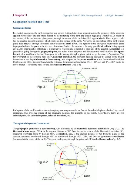
<strong>The</strong> geographic position <strong>of</strong> a celestial body, GP, is defined by the equatorial system <strong>of</strong> coordinates (Fig. 3-2). <strong>The</strong><br />
Greenwich hour angle, GHA, is the angular distance <strong>of</strong> GP from the upper branch <strong>of</strong> the Greenwich meridian (0°),<br />
measured westward from 0° through 360°. Declination, Dec, is the angular distance <strong>of</strong> GP from the plane <strong>of</strong> the<br />
equator, measured northward through +90° or southward through –90°. GHA and Dec are geocentric coordinates<br />
(measured at the center <strong>of</strong> the earth). <strong>The</strong> great circle going through the poles and GP is called hour circle (Fig. 3-2).
GHA and Dec are equivalent to geocentric longitude and latitude with the exception that longitude is measured<br />
westward through −180° and eastward through +180°.<br />
Since the Greenwich meridian rotates with the earth from west to east, whereas each hour circle remains linked<br />
with the almost stationary position <strong>of</strong> the respective body in the sky, the Greenwich hour angles <strong>of</strong> all celestial<br />
bodies increase by approx. 15° per hour (360° in 24 hours). In contrast to stars (15° 2.46' /h), the GHA's <strong>of</strong> sun,<br />
moon, and planets increase at slightly different (and variable) rates. This is caused by the revolution <strong>of</strong> the planets<br />
(including the earth) around the sun and by the revolution <strong>of</strong> the moon around the earth, resulting in additional apparent<br />
motions <strong>of</strong> these bodies in the sky. In many cases, it is useful to measure the angular distance between the hour circle <strong>of</strong><br />
a celestial body and the hour circle <strong>of</strong> a reference point in the sky instead <strong>of</strong> the Greenwich meridian because the angle<br />
thus obtained is independent <strong>of</strong> the earth's rotation. <strong>The</strong> sidereal hour angle, SHA, is the angular distance <strong>of</strong> a body<br />
from the hour circle (upper branch) <strong>of</strong> the first point <strong>of</strong> Aries (also called vernal equinox, see below), measured<br />
westward from 0° through 360°. Thus, the GHA <strong>of</strong> a body is the sum <strong>of</strong> the SHA <strong>of</strong> the body and GHA Aries, the GHA<br />
<strong>of</strong> the first point <strong>of</strong> Aries, :<br />
GHA = SHA +<br />
(If the resulting GHA is greater than 360°, subtract 360°.)<br />
<strong>The</strong> angular distance <strong>of</strong> a body eastward from the hour circle <strong>of</strong> the vernal equinox, measured in time units (24h =<br />
360°), is called right ascension, RA. Right ascension is mostly used by astronomers whereas navigators prefer SHA.<br />
[ ° ]<br />
Fig. 3-3 illustrates how the various hour angles are interrelated.<br />
GHAAries<br />
SHA<br />
RA[ h ] = 24<br />
h −<br />
⇔ SHA<br />
15⋅<br />
15<br />
[ ° ] = 360°<br />
− RA[<br />
h ]<br />
Declinations are not affected by the rotation <strong>of</strong> the earth. <strong>The</strong> declinations <strong>of</strong> sun and planets change primarily due to the<br />
obliquity <strong>of</strong> the ecliptic, the inclination <strong>of</strong> the earth's equator to the ecliptic. <strong>The</strong> latter is the plane <strong>of</strong> the earth's orbit<br />
and forms a great circle on the celestial sphere. <strong>The</strong> declination <strong>of</strong> the sun, for example, varies periodically between ca.<br />
+23.5° at the time <strong>of</strong> the summer solstice and ca. -23.5° at the time <strong>of</strong> the winter solstice. (Fig.3-4).<br />
<strong>The</strong> two points on the celestial sphere where the great circle <strong>of</strong> the ecliptic intersects the celestial equator are called<br />
equinoxes. <strong>The</strong> term equinox is also used for the time at which the apparent sun, moving westward along the ecliptic,<br />
passes through either <strong>of</strong> these points, approximately on March 21 and on September 23. Accordingly, there is a vernal<br />
equinox (first point <strong>of</strong> Aries, vernal point) and an autumnal equinox. <strong>The</strong> former is the reference point for measuring<br />
sidereal hour angles (Fig. 3-5).
When the sun passes through either <strong>of</strong> the equinoxes (Dec ≈ 0), day and night have (approximately) the same length,<br />
regardless <strong>of</strong> the observer's position (Lat. aequae noctes = equal nights).<br />
Fig. 3-5<br />
Winter Solstice<br />
Declinations <strong>of</strong> the planets and the moon are also influenced by the inclinations <strong>of</strong> their own orbits to the ecliptic. <strong>The</strong><br />
plane <strong>of</strong> the moon's orbit, for example, is inclined to the ecliptic by approx. 5° and makes a tumbling movement<br />
(precession, see below) with a cycle <strong>of</strong> 18.6 years (Saros cycle). As a result, the declination <strong>of</strong> the moon varies between<br />
approx. -28.5° and +28.5° at the beginning and at the end <strong>of</strong> the Saros cycle, and between approx. -18.5° and +18.5° in<br />
the middle <strong>of</strong> the Saros cycle.<br />
Further, sidereal hour angles and declinations <strong>of</strong> all bodies change slowly due to the influence <strong>of</strong> the precession <strong>of</strong> the<br />
earth's polar axis. Precession is a slow, tumbling movement <strong>of</strong> the polar axis along the surface <strong>of</strong> an imaginary double<br />
cone. One revolution takes about 26000 years (Platonic year). As a result, the equinoxes move westward along the<br />
celestial equator at a rate <strong>of</strong> approx. 50'' per year. Thus, the sidereal hour angle <strong>of</strong> each star decreases at about the same<br />
rate. In addition, the polar axis makes a small elliptical oscillation, called nutation, which causes the equinoxes to travel<br />
along the celestial equator at a periodically changing rate, and we have to distinguish between the ficticious mean<br />
equinox <strong>of</strong> date and the true equinox <strong>of</strong> date (see time measurement). Accordingly, the declination <strong>of</strong> each body<br />
oscillates. <strong>The</strong> same applies to the rate <strong>of</strong> change <strong>of</strong> the sidereal hour angle and right ascension <strong>of</strong> each body.<br />
Even stars are not fixed in space but move individually, resulting in a slow drift <strong>of</strong> their equatorial coordinates (proper<br />
motion). Finally, the apparent positions <strong>of</strong> bodies are influenced by the limited speed <strong>of</strong> light (light time, aberration),<br />
and, to a small extent, by annual parallax [16]. <strong>The</strong> accurate prediction <strong>of</strong> geographic positions <strong>of</strong> celestial bodies<br />
requires complicated algorithms. Formulas for the calculation <strong>of</strong> low-precision ephemerides <strong>of</strong> the sun (accurate<br />
enough for celestial navigation) are given in chapter 15.<br />
Time measurement in navigation and astronomy<br />
Ecliptic<br />
Vernal Equinox<br />
Earth<br />
Autumnal Equinox<br />
<strong>Celestial</strong> Equator<br />
Due to the rapid change <strong>of</strong> Greenwich hour angles, celestial navigation requires accurate time measurement, and<br />
the time at the instant <strong>of</strong> observation should be noted to the second if possible. This is usually done by means <strong>of</strong> a<br />
chronometer and a stopwatch. <strong>The</strong> effects <strong>of</strong> time errors are dicussed in chapter 16. On the other hand, the earth's<br />
rotation with respect to celestial bodies provides an important basis for astronomical time measurement.<br />
Coordinates tabulated in the Nautical Almanac refer to Universal Time, UT. UT has replaced Greenwich Mean<br />
Time, GMT, the traditional basis for civil time keeping. Conceptually, UT (like GMT) is the hour angle <strong>of</strong> the fictitious<br />
mean sun, expressed in hours, with respect to the lower branch <strong>of</strong> the Greenwich meridian (mean solar time, Fig. 3-6).<br />
Sun<br />
<strong>Celestial</strong> Sphere<br />
Summer Solstice
UT is calculated using the following formula:<br />
UT<br />
[ h ] = GMT [ h ]<br />
(If UT is greater than 24 h, subtract 24 hours.)<br />
By definition, the GHA <strong>of</strong> the mean sun increases by exactly 15° per hour, completing a 360° cycle in 24 hours. <strong>The</strong><br />
unit for UT (and GMT) is 1 solar day, the time interval between two consecutive meridian transits <strong>of</strong> the mean sun.<br />
<strong>The</strong> rate <strong>of</strong> change <strong>of</strong> the GHA <strong>of</strong> the apparent (observable) sun varies periodically and is sometimes slightly greater,<br />
sometimes slightly smaller than 15° per hour during the course <strong>of</strong> a year. This behavior is caused by the eccentricity <strong>of</strong><br />
the earth's orbit and by the obliquity <strong>of</strong> the ecliptic. <strong>The</strong> time measured by the hour angle <strong>of</strong> the apparent sun with<br />
respect to the lower branch <strong>of</strong> the Greenwich meridian is called Greenwich Apparent Time, GAT. A calibrated sundial<br />
located at the Greenwich meridian, for example, would indicate GAT. <strong>The</strong> difference between GAT and UT (GMT) is<br />
called equation <strong>of</strong> time, EoT:<br />
EoT varies periodically between approx. −14 and +17 minutes (Fig. 3-7). Predicted values for EoT for each day <strong>of</strong> the<br />
year (at 0:00 and 12:00 UT) are given in the Nautical Almanac (grey background indicates negative EoT). EoT is<br />
needed when calculating times <strong>of</strong> sunrise and sunset, or determining a noon longitude (see chapter 6). Formulas for the<br />
calculation <strong>of</strong> EoT are given in chapter 15.<br />
<strong>The</strong> hour angle <strong>of</strong> the mean sun with respect to the lower branch <strong>of</strong> the local meridian (the meridian going through the<br />
observer's position) is called Local Mean Time, LMT. LMT and UT are linked through the following formula:<br />
LMT<br />
<strong>The</strong> instant <strong>of</strong> the mean sun passing through the local meridian (upper branch) is called Local Mean Noon, LMN.<br />
A zone time is the local mean time with respect to a longitude being a multiple <strong>of</strong> ±15°. Thus, zone times differ by an<br />
integer number <strong>of</strong> hours. In the US, for example, Eastern Standard Time (UT−5h) is LMT at −75° longitude, Pacific<br />
Standard Time (UT−8h) is LMT at −120° longitude. Central European Time (UT+1h) is LMT at +15° longitude.<br />
<strong>The</strong> hour angle <strong>of</strong> the apparent sun with respect to the lower branch <strong>of</strong> the local meridian is called Local Apparent<br />
Time, LAT:<br />
LAT<br />
<strong>The</strong> instant <strong>of</strong> the apparent sun crossing the local meridian (upper branch) is called Local Apparent Noon, LAN.<br />
=<br />
GHAMeanSun<br />
15<br />
EoT = GAT − UT<br />
[ h ] = UT [ h ]<br />
[ h ] = GAT [ h ]<br />
Lon<br />
+<br />
Lon<br />
+<br />
[ ° ]<br />
[ ° ]<br />
15<br />
[ ° ]<br />
15<br />
+ 12
Time measurement by the earth's rotation does not necessarily require the sun as the reference point in the sky.<br />
Greenwich Apparent Sidereal Time, GAST, is a time scale based upon the Greenwich hour angle (upper branch) <strong>of</strong><br />
the true vernal equinox <strong>of</strong> date, GHA Aries (see Fig. 3-3).<br />
GAST<br />
<strong>The</strong> values for GHA Aries tabulated in the Nautical Almanac refer to the true equinox <strong>of</strong> date.<br />
GAST is easily measured by the Greenwich meridian transit <strong>of</strong> stars since GAST and the right ascension <strong>of</strong> the observed<br />
star are numerically equal at the moment <strong>of</strong> meridian transit.<br />
<strong>The</strong> Greenwich hour angle <strong>of</strong> the imaginary mean vernal equinox <strong>of</strong> date (traveling along the celestial equator at a<br />
constant rate) defines Greenwich Mean Sidereal Time, GMST. <strong>The</strong> difference to GMST is called equation <strong>of</strong> the<br />
equinoxes, EQ, or nutation in right ascension. EQ can be predicted precisely. It varies within approx. ±1s.<br />
GMST is <strong>of</strong> some importance for it is the actual basis for UT. Since time measurement by meridian transits <strong>of</strong> the sun is<br />
not accurate enough for many scientific applications, Universal Time is by definition calculated from GMST. This is<br />
possible because there is a close correlation between GMST and mean solar time at Greenwich. <strong>The</strong> time thus obtained<br />
is called UT0. Applying a small correction (milliseconds) for the effects <strong>of</strong> polar motion (a quasi-circular movement <strong>of</strong><br />
the earth's crust with respect to the axis <strong>of</strong> rotation) yields UT1, commonly called UT.<br />
Due to the earth's revolution around the sun, a mean sidereal day (the time interval between two concecutive meridian<br />
transits <strong>of</strong> the mean equinox) is slightly shorter than a mean solar day:<br />
24 h mean sidereal time =<br />
In analogy with LMT and LAT, there is a Local Mean Sidereal Time, LMST, and a Local Apparent Sidereal Time,<br />
LAST:<br />
LMST<br />
[ h ] = GMST [ h ]<br />
Lon<br />
+<br />
15<br />
Solar time and sidereal time are both linked to the earth's rotation. <strong>The</strong> earth's rotational speed, however, decreases<br />
slowly (tidal friction) and, moreover, fluctuates in an unpredictable manner due to random movements <strong>of</strong> matter within<br />
the earth's body (magma) and on the surface (water, air). <strong>The</strong>refore, neither <strong>of</strong> both time scales is strictly uniform. Many<br />
astronomical applications, however, require a linear time scale. One example is the calculation <strong>of</strong> ephemerides since the<br />
motions <strong>of</strong> celestial bodies in space are independent <strong>of</strong> the earth's rotation.<br />
International Atomic Time, TAI, is the most precise time standard presently available. It is obtained by statistical<br />
analysis <strong>of</strong> data supplied by a great number <strong>of</strong> atomic clocks all over the world. Among others, two important time<br />
scales are derived from TAI:<br />
Today, civil life is mostly determined by Coordinated Universal Time, UTC, which is the basis for time signals<br />
broadcast by radio stations, e. g., WWV or WWVH. UTC is controlled by TAI. Due to the varying rotational speed <strong>of</strong><br />
the earth, UT tends to drift away from UTC. This is undesirable since the cycle <strong>of</strong> day and night is linked to UT.<br />
<strong>The</strong>refore, UTC is synchronized to UT, if necessary, by inserting (or omitting) leap seconds at certain times (June 30<br />
and December 31) in order to avoid that the difference, ∆UT, exceeds the specified maximum value <strong>of</strong> ±0.9 s.<br />
UT = UTC + ΔUT<br />
UTC = TAI −<br />
N is the cumulative number <strong>of</strong> leap seconds inserted until now (N = 32 in 2004.0). Due to the occasional leap seconds,<br />
UTC is not a continuous time scale! Predicted values for ∆UT (= UT1-UTC) are published by the IERS Rapid Service<br />
[15] on a weekly basis (IERS Bulletin A). <strong>The</strong> IERS also announces the insertion (or omission) <strong>of</strong> leap seconds in<br />
advance (IERS Bulletins A + C).<br />
Terrestrial Time, TT (formerly called Terrestrial Dynamical Time, TDT), is another derivative <strong>of</strong> TAI:<br />
TT<br />
[ h ]<br />
=<br />
GHAAries<br />
15<br />
N<br />
= TAI + 32.<br />
184s<br />
[ ° ]<br />
EQ =<br />
GAST − GMST<br />
23h<br />
56 m 4.<br />
090524s<br />
[ ° ]<br />
LAST<br />
mean solar time<br />
[ h ] = GAST [ h ]<br />
Lon<br />
+<br />
15<br />
[ ° ]
TT has replaced Ephemeris Time, ET. <strong>The</strong> <strong>of</strong>fset <strong>of</strong> 32.184 s with respect to TAI is necessary to ensure a seamless<br />
continuation <strong>of</strong> ET. TT is used in astronomy (calculation <strong>of</strong> ephemerides) and space flight. <strong>The</strong> difference between TT<br />
and UT is called ∆T:<br />
ΔT<br />
= TT −UT<br />
At the beginning <strong>of</strong> the year 2004, ∆T was +64.6s. ∆T is <strong>of</strong> some importance since computer almanacs require TT<br />
(TDT) as time argument (programs using UT calculate on the basis <strong>of</strong> extrapolated ∆T values). A precise long-term<br />
prediction <strong>of</strong> ∆T is impossible. <strong>The</strong>refore, computer almanacs using only UT as time argument may become less<br />
accurate in the long term. ∆T values for the near future can be calculated with the following formula:<br />
Like UT1-UTC, TAI-UTC (cumulative number <strong>of</strong> leap seconds) is published in the IERS Bulletin A.<br />
A final remark on GMT:<br />
<strong>The</strong> term GMT has become ambigous since it is <strong>of</strong>ten used as a synonym for UTC now. Moreover, astronomers<br />
used to reckon GMT from the upper branch <strong>of</strong> the Greenwich meridian until 1925 (the time thus obtained is<br />
sometimes called Greenwich Mean Astronomical Time, GMAT). <strong>The</strong>refore, the term GMT should be avoided in<br />
scientific publications, except when used in a historical context.<br />
<strong>The</strong> Nautical Almanac<br />
( TAI −UTC<br />
) − ( UT UTC)<br />
ΔT = 32.<br />
184s<br />
+<br />
1−<br />
Predicted values for GHA and Dec <strong>of</strong> sun, moon and the navigational planets with reference to UT are tabulated for<br />
each whole hour <strong>of</strong> the year on the daily pages <strong>of</strong> the Nautical Almanac, N.A., and similar publications [12, 13].<br />
GHA Aries is tabulated in the same manner.<br />
Listing GHA and Dec <strong>of</strong> all 57 fixed stars used in navigation for each whole hour <strong>of</strong> the year would require too much<br />
space. Since declinations and sidereal hour angles <strong>of</strong> stars change only slowly, tabulated values for periods <strong>of</strong> 3 days are<br />
accurate enough for navigational purposes.<br />
GHA and Dec for each second <strong>of</strong> the year are obtained using the interpolation tables at the end <strong>of</strong> the N.A. (printed on<br />
tinted paper), as explained in the following directions:<br />
1.<br />
We note the exact time <strong>of</strong> observation (UT), determined with a chronometer, for each celestial body. If UT is not<br />
available, we can use UTC. <strong>The</strong> resulting error is tolerable in most cases.<br />
We look up the day <strong>of</strong> observation in the N.A. (two pages cover a period <strong>of</strong> three days).<br />
2.<br />
3.<br />
We go to the nearest whole hour preceding the time <strong>of</strong> observation and note GHA and Dec <strong>of</strong> the observed body. In case<br />
<strong>of</strong> a fixed star, we form the sum <strong>of</strong> GHA Aries and the SHA <strong>of</strong> the star, and note the tabulated declination. When<br />
observing planets, we note the v and d factors given at the bottom <strong>of</strong> the appropriate column. For the moon, we take v<br />
and d for the nearest whole hour preceding the time <strong>of</strong> observation.<br />
<strong>The</strong> quantity v is necessary to apply an additional correction to the following interpolation <strong>of</strong> the GHA <strong>of</strong> moon and<br />
planets. It is not required for stars. <strong>The</strong> sun does not require a v factor since the correction has been incorporated in the<br />
tabulated values for the sun's GHA.<br />
<strong>The</strong> quantity d, which is negligible for stars, is the rate <strong>of</strong> change <strong>of</strong> Dec, measured in arcminutes per hour. It is needed<br />
for the interpolation <strong>of</strong> Dec. <strong>The</strong> sign <strong>of</strong> d is critical!
4.<br />
We look up the minute <strong>of</strong> observation in the interpolation tables (1 page for each 2 minutes <strong>of</strong> the hour), go to the<br />
second <strong>of</strong> observation, and note the increment from the respective column.<br />
We enter one <strong>of</strong> the three columns to the right <strong>of</strong> the increment columns with the v and d factors and note the<br />
corresponding corr(ection) values (v-corr and d-corr).<br />
<strong>The</strong> sign <strong>of</strong> d-corr depends on the trend <strong>of</strong> declination at the time <strong>of</strong> observation. It is positive if Dec at the whole hour<br />
following the observation is greater than Dec at the whole hour preceding the observation. Otherwise it is negative.<br />
v -corr is negative for Venus. Otherwise, it is always positive.<br />
We form the sum <strong>of</strong> Dec and d-corr (if applicable).<br />
We form the sum <strong>of</strong> GHA (or GHA Aries and SHA <strong>of</strong> star), increment, and v-corr (if applicable).<br />
SHA values tabulated in the Nautical Almanac refer to the true vernal equinox <strong>of</strong> date.<br />
Interactive Computer Ephemeris<br />
5.<br />
Interactive Computer Ephemeris, ICE, is a computer almanac developed by the U.S. Naval Observatory (successor <strong>of</strong><br />
the Floppy Almanac).<br />
ICE is FREEWARE (no longer supported by USNO), compact, easy to use, and provides a vast quantity <strong>of</strong> accurate<br />
astronomical data for a time span <strong>of</strong> almost 250 (!) years. In spite <strong>of</strong> the old design (DOS program), ICE is an extremely<br />
useful tool for navigators and astronomers.<br />
Among many other features, ICE calculates GHA and Dec for a given body and time as well as altitude and azimuth <strong>of</strong><br />
the body for an assumed position (see chapter 4) and sextant altitude corrections. Since the navigation data are as<br />
accurate as those tabulated in the Nautical Almanac (approx. 0.1'), the program makes an adequate alternative,<br />
although a printed almanac (and sight reduction tables) should be kept as a backup in case <strong>of</strong> a computer failure. <strong>The</strong><br />
following instructions refer to the final version (0.51). Only program features relevant to navigation are explained.<br />
1. Installation<br />
Copy the program files to a chosen directory on the hard drive or to a floppy disk.<br />
2. Getting Started<br />
Go to the program directory (or floppy disk) and enter "ice". <strong>The</strong> main menu appears.<br />
Use the function keys F1 to F10 to navigate through the submenus. <strong>The</strong> program is more or less self-explanatory.<br />
Go to the submenu INITIAL VALUES (F1). Follow the directions on the screen to enter date and time <strong>of</strong> observation<br />
(F1), assumed latitude (F2), assumed longitude (F3), and your local time zone (F6). Assumed latitude and longitude<br />
define your assumed position.<br />
Use the correct data format, as shown on the screen (decimal format for latitude and longitude). After entering the above<br />
data, press F7 to accept the values displayed. To change the default values permanently, edit the file ice.dft with a text<br />
editor (after making a backup copy) and make the desired changes. Do not change the data format. <strong>The</strong> numbers have to<br />
be in columns 21-40. An output file can be created to store calculated data. Go to the submenu FILE OUTPUT (F2) and<br />
enter a chosen file name, e.g., OUTPUT.TXT.<br />
3. Calculation <strong>of</strong> Navigational Data<br />
From the main menu, go to the submenu NAVIGATION (F7). Enter the name <strong>of</strong> the body. <strong>The</strong> program displays GHA<br />
and Dec <strong>of</strong> the body, GHA and Dec <strong>of</strong> the sun (if visible), and GHA <strong>of</strong> the vernal equinox for the date and time (UT)<br />
stored in INITIAL VALUES.
Hc (computed altitude) and Zn (azimuth) mark the apparent position <strong>of</strong> the body as observed from the assumed position.<br />
Approximate altitude corrections (refraction, SD, PA), based upon Hc, are also displayed (for lower limb <strong>of</strong> body). <strong>The</strong><br />
semidiameter <strong>of</strong> the moon includes augmentation. <strong>The</strong> coordinates calculated for Venus and Mars do not include phase<br />
correction. <strong>The</strong>refore, the upper or lower limb (if visible) should be observed. ΔT is TDT-UT, the predicted difference<br />
between terrestrial dynamical time and UT for the given date. <strong>The</strong> ΔT value for 2004.0 predicted by ICE is 66.1s, the<br />
actual value is 64.6s (see below).<br />
Horizontal parallax and semidiameter <strong>of</strong> a body can be extracted, if required, from the submenu POSITIONS (F3).<br />
Choose APPARENT GEOCENTRIC POSITIONS (F1) and enter the name <strong>of</strong> the body (sun, moon, planets). <strong>The</strong> last<br />
column shows the distance <strong>of</strong> the center <strong>of</strong> the body from the center <strong>of</strong> the earth, measured in astronomical units (1 AU<br />
= 149.6 . 10 6 km). HP and SD are calculated as follows:<br />
HP<br />
r E is the equatorial radius <strong>of</strong> the earth (6378 km). r B is the radius <strong>of</strong> the body (Sun: 696260 km, Moon: 1378 km, Venus:<br />
6052 km, Mars: 3397 km, Jupiter: 71398 km, Saturn: 60268 km).<br />
<strong>The</strong> apparent geocentric positions refer to TDT, but the difference between TDT and UT has no significant effect on HP<br />
and SD.<br />
To calculate times <strong>of</strong> rising and setting <strong>of</strong> a body, go to the submenu RISE & SET TIMES (F6) and enter the name <strong>of</strong><br />
the body. <strong>The</strong> columns on the right display the time <strong>of</strong> rising, meridian transit, and setting for the assumed location<br />
(UT+xh, according to the time zone specified).<br />
<strong>The</strong> increasing error <strong>of</strong> ΔT values predicted by ICE may lead to reduced precision when calculating navigation data for<br />
the future. <strong>The</strong> coordinates <strong>of</strong> the moon are particularly sensitive to errors <strong>of</strong> ΔT. Unfortunately, ICE has no option for<br />
editing and modifying ΔT. <strong>The</strong> high-precision part <strong>of</strong> ICE, however, is not affected since TDT is the time argument. To<br />
extract GHA and Dec, the following procedure is recommended:<br />
1. Compute GAST using SIDEREAL TIME (F5). <strong>The</strong> time argument is UT.<br />
2. Edit date and time at INITIAL VALUES (F1). <strong>The</strong> new time argument is UT+ΔT. Compute RA and Dec using<br />
POSITIONS (F3) and APPARENT GEOCENTRIC POSITIONS (F1).<br />
3. Use the following formula to calculate GHA from GAST and RA (RA refers to the true vernal equinox <strong>of</strong> date):<br />
Add or subtract 360° if necessary.<br />
[ km]<br />
[ km]<br />
rE<br />
rB<br />
= arcsin SD = arcsin<br />
distance<br />
distance<br />
[ ° ] = 15⋅<br />
( GAST [ h ] + 24h<br />
RA [ h ] )<br />
GHA −<br />
[ km]<br />
[ km]<br />
High-precision GHA and Dec values thus obtained can be used as an internal standard to check medium-precision data<br />
obtained through NAVIGATION (F7).


