Venus Earth Mars - Earth and Space Sciences
Venus Earth Mars - Earth and Space Sciences
Venus Earth Mars - Earth and Space Sciences

You also want an ePaper? Increase the reach of your titles
YUMPU automatically turns print PDFs into web optimized ePapers that Google loves.
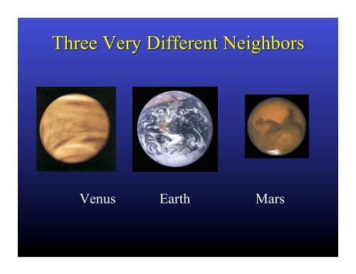
<strong>Venus</strong> <strong>Earth</strong> <strong>Mars</strong>
Mean Orbital Radius: 0.72 AU<br />
Equatorial Radius: 0.95x<strong>Earth</strong> Radius<br />
Mean Surface Temperature: 462C (864F)<br />
Mean Surface Atmospheric Pressure: 92 bar, <strong>and</strong> parched
Mean Orbital Radius: 1.00 AU<br />
Equatorial Radius: 6378 km<br />
Mean Surface Temperature: 15C<br />
Mean Surface Pressure: 1 bar, swimming in water
Mean Orbital Radius: 1.50 AU<br />
Equatorial Radius: 0.53x <strong>Earth</strong> Radius<br />
Mean Surface Temperature: -63C (-81F)<br />
Mean Surface Atmospheric Pressure: 0.006 bar, <strong>and</strong> parched
<strong>Venus</strong> was supposed (ca. mid-20 th century) to be an exotic,<br />
steamy jungle beneath its clouds.<br />
<strong>Mars</strong> was supposed to be Barsoom, or at least “Taos without<br />
the tourists” (Burkhard Bilger, “The Martian Chroniclers”, The<br />
New Yorker, 22 April 2013, http://www.newyorker.com/reporting/<br />
2013/04/22/130422fa_fact_bilger)
<strong>Mars</strong> was an unfortunate runt (maybe prevented from growing<br />
by Jupiter – Walsh et al., “A low mass for <strong>Mars</strong> from Jupiter’s<br />
early gas-driven migration”, Nature 475, 206-209, 2011).<br />
It got cold early, lost it’s early dynamo <strong>and</strong> associated magnetic<br />
field.<br />
The Sun blew away it’s atmosphere <strong>and</strong> with it a lot of its water.<br />
All this happened by ~ 3.5 billion years ago – maybe a billion<br />
years before widespread oxygenic photosynthesis on <strong>Earth</strong>.
Formation of Glaciers<br />
by Atmospheric<br />
Precipitation at High<br />
Obliquity, Forget et al.,<br />
Science 311, 2006.<br />
Buried ice on <strong>Mars</strong>:<br />
Radar evidence for<br />
remnant glaciers in<br />
the southern midlatitudes,<br />
Holt, et al.,<br />
Science, 2008.<br />
.<br />
Relict ice deposits, geological evidence of<br />
flowing glaciers in past
Dynamic Ice Reservoirs<br />
• On 100,000 to 5M yr. (obliquity)<br />
time scales (J.W. Head III et al.,<br />
“Recent Ice Ages on <strong>Mars</strong>”,<br />
Nature 426, 2003)<br />
• Perhaps on 25,000 yr.<br />
(precessional) time scales (R.M.<br />
Haberle, Eos Trans. AGU 84(46),<br />
Fall Meeting Suppl. Abstract<br />
P42C-04, 2003.<br />
• Decadale-scale variation in global<br />
temperature driven by dust-related<br />
albedo change (Fenton,Geissler<br />
<strong>and</strong> Haberle, Nature 446, 2007)
What Can We Learn from <strong>Mars</strong>’ Polar Ice Caps<br />
Dale P. Winebrenner 1, Michelle Koutnik 1 , Edwin D. Waddington 1 , Asmin V.<br />
Pathare 2 , Shane Byrne 3 , <strong>and</strong> Bruce C. Murray 4<br />
1<br />
University of Washington<br />
2<br />
Planetary Science Institute<br />
3<br />
University of Arizona<br />
4<br />
California Institute of Technology
Stratification exposed on scarps -- layers of differing dustiness<br />
deposited in differing climate episodes
Figure from Clifford et al. (2000) Icarus 144, 210-242.<br />
ca. 600 km across, on exceptionally flat<br />
northern plains<br />
Up to 3 km thick, but low elevation wrt<br />
global mean geoid (base ca. -5100 m)<br />
Volume approx 1.5x10 6 km 3 (about half<br />
that of Greenl<strong>and</strong>, 1/20th that of<br />
Antarctica)<br />
Mean annual T s : 162K (-111C), basal heat<br />
flux unknown (30 mW/m 2 )<br />
Water ice exposed on young surface<br />
Some evidence for underlying, dustcovered<br />
deposit (of ice)<br />
Incision by strange troughs, <strong>and</strong> an<br />
enormous chasma (Chasma Boreale)<br />
Note Titania Lobe/Gemina Lingula
(Bamber, 2004)<br />
On <strong>Earth</strong>:<br />
• Long, near-linear ridge lines with near-uniform gradient along their<br />
length are characteristic of flow divides on deforming ice sheets
St<strong>and</strong>ard shadedrelief<br />
MOLA DEM<br />
Shaded to make<br />
high elevations<br />
with low slopes<br />
st<strong>and</strong> out<br />
• Resemblance is not identity, but let’s test.<br />
• Feature is cut relatively little by troughs.<br />
• Troughs apparently expose internal layers.
On <strong>Earth</strong>, flow thins layers at depth,<br />
so “reading” stratigraphy requires<br />
correction for strain.<br />
Do Martian ice caps flow<br />
• Of course! How could they not<br />
• The question is: How fast (in<br />
comparison to rates of other processes<br />
that might sculpt the caps)
Ice always “flows”…<br />
We can consider if flow controls the surface shape relative to other processes.<br />
Flow number:<br />
Surface mass exchange<br />
with the atmosphere<br />
Move ice over the length<br />
of the glacier by flow<br />
F > 1: flow controls surface shape<br />
Winebrenner et al. (2008)
Estimation of Pre-Trough Surface Topography<br />
1) Exclude places where<br />
slope exceeds 0.015<br />
radians.<br />
2) Exclude places in bottoms<br />
of troughs where slope is<br />
near-zero.<br />
3) Bridge<br />
troughs by<br />
linear<br />
interpolation.<br />
4) Smooth.
Surface with Troughs Interpolated <strong>and</strong> Smoothed<br />
Aspect<br />
Contours
C<strong>and</strong>idate Flow Lines AS IF Troughs Were Filled with Ice<br />
Aspect<br />
Contours
Simple, Steady-State Ice-Flow Model for Topography<br />
• steady-state flow equilibrates surface mass fluxes<br />
• flat bed (at -5100 m), no sliding (cold)<br />
• 2 spatial dimensions<br />
• incompressible, non-Newtonian fluid – flow law exponent n.<br />
• temperature constant over depth<br />
• neglect longitudinal stresses <strong>and</strong> vertical velocities<br />
• works surprisingly well in East Antarctica
Steady-State Ice-Flow Model for Topography<br />
• steady-state flow equilibrates surface mass fluxes<br />
• flat bed (at -5100 m), no sliding (cold)<br />
• 2 spatial dimensions<br />
• incompressible, non-Newtonian fluid – flow law exponent n.<br />
• temperature constant over depth<br />
• neglect longitudinal stresses <strong>and</strong> vertical velocities<br />
accumulation, c<br />
⎛⎛<br />
⎜⎜<br />
⎝⎝<br />
h<br />
H<br />
2+<br />
⎞⎞<br />
2 n ⎛⎛ c ⎞⎞<br />
⎟⎟ + ⎜⎜ 1+ ⎟⎟<br />
⎠⎠ ⎝⎝ a⎠⎠<br />
1<br />
n<br />
⎛⎛ x ⎞⎞<br />
⎜⎜ ⎟⎟<br />
⎝⎝ L⎠⎠<br />
1+ 1 n<br />
=1<br />
H<br />
x = 0<br />
h(x)<br />
equilibrium line<br />
€<br />
x = L<br />
x = R €<br />
ablation, a<br />
⎛⎛<br />
⎜⎜<br />
⎝⎝<br />
h<br />
H<br />
⎞⎞<br />
⎟⎟<br />
⎠⎠<br />
2<br />
⎛⎛<br />
= 1+ a ⎞⎞ n +1⎛⎛<br />
x ⎞⎞<br />
⎜⎜ ⎟⎟ ⎜⎜ 1− ⎟⎟<br />
⎝⎝ c ⎠⎠ ⎝⎝ L⎠⎠<br />
Flux balances integrals of mass<br />
balance, so shape insensitive to<br />
details of spatial pattern<br />
1
Fits in Places with Seemingly Ablated Topography Don’t Fit<br />
a Flow model (one of the 11, not one of the 40)<br />
RMS Difference 44 m (<strong>and</strong> greater)
But Everywhere with Extensive ‘Relict’ Topography Does<br />
Fit, With Consistent (Inferred) Parameters
Again
And Again
Inferred Terminus Positions <strong>and</strong> Even Equilibrium<br />
Line Positions Tell a Consistent Story
The shape of an F~1 ice mass is generic.<br />
Gemina Lingula<br />
East Antarctica: F~1<br />
Gemina Lingula: F~1<br />
Meighen Ice Cap, Arctic Canada: F
Interpretation<br />
Climate<br />
Change<br />
1. Flowing Ice Sheet<br />
with Accumulation<br />
<strong>and</strong> Ablation Zones<br />
(Sometime in the<br />
Past)<br />
2. Flow (<strong>and</strong> Accumulation)<br />
Largely Stopped
3. Trough Incision in Stopped Ice Sheet Produces Present-Day<br />
Topography of Titania Lobe
Relict Surface<br />
Claim: The present-day topography of Titania<br />
Lobe preserves evidence of flow prior to trough<br />
formation.
In the Accumulation Zone: NO intersection of subsurface<br />
layers with surface ALONG FLOW LINES<br />
In the Ablation Zone: Layers expected to intersect surface<br />
ALONG FLOW LINES
23<br />
25
Relict<br />
topography<br />
near<br />
terminus
PRESENT DAY<br />
MOLA along<br />
Gemina Lingula<br />
Surface in<br />
steady state with<br />
present-day conditions
PRESENT DAY<br />
Surface temperature = 170 K:<br />
Ablation rate = 8 × 10 -6 mm/yr<br />
Volume response time = 232 Gyr<br />
!!!<br />
Ablation rate = 0.2 mm/yr:<br />
(Pathare <strong>and</strong> Paige, 2005)<br />
Surface temperature = 228 K<br />
Volume response time = 9.5 Myr
Phillips et al., Science 2008<br />
• Almost impossible to warm base of NPLD to 240K via surface<br />
temperature increase, even at high obliquity (A .V. Pathare, pers. comm.)<br />
• Lack of isostatic compensation of NPLD indicates a very cold, stiff<br />
mantle (Phillips, Zuber et al., Science, 2008), indicating small geothermal<br />
heat fluxes<br />
SO HOW DID THE ICE GET WARM ENOUGH TO FLOW
Credit: C.A. Raymond
€
€
Figure 2 of Holt et al., Nature 465, 27 May 2010|, doi:10.1038/nature09050
‘proto-GL’<br />
600-800 m<br />
thick beneath<br />
GL dome<br />
€<br />
extends with<br />
thicknesses<br />
< 400 m into<br />
‘flowtopography’<br />
region (1600m<br />
dividethickness)<br />
Figure S4, Holt et<br />
al. (2010)