Introduction to Natural Hazards - heltschl
Introduction to Natural Hazards - heltschl Introduction to Natural Hazards - heltschl
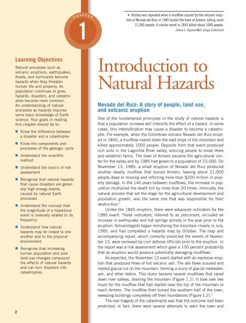
Learning Objectives Natural processes such as volcanic eruptions, earthquakes, floods, and hurricanes become hazards when they threaten human life and property. As population continues to grow, hazards, disasters, and catastrophes become more common. An understanding of natural processes as hazards requires some basic knowledge of Earth science. Your goals in reading this chapter should be to: ■ Know the difference between a disaster and a catastrophe ■ Know the components and processes of the geologic cycle ■ Understand the scientific method ■ Understand the basics of risk assessment ■ Recognize that natural hazards that cause disasters are generally high-energy events, caused by natural Earth processes ■ Understand the concept that the magnitude of a hazardous event is inversely related to its frequency ■ Understand how natural hazards may be linked to one another and to the physical environment ■ Recognize that increasing human population and poor land-use changes compound the effects of natural hazards and can turn disasters into catastrophes 2 C H A P T 1 E R History was repeated when a mudflow caused by the volcanic eruption of Nevado del Ruiz in 1985 buried the town of Armero, killing some 21,000 people. A similar event in 1845 killed about 1000 people. (Steve L. Raymer/NGC Image Collection) ▼ Introduction to Natural Hazards Nevado del Ruiz: A story of people, land use, and volcanic eruption One of the fundamental principles in the study of natural hazards is that a population increase will intensify the effect of a hazard. In some cases, this intensification may cause a disaster to become a catastrophe. For example, when the Colombian volcano Nevado del Ruiz erupted in 1845, a mudflow roared down the east slope of the mountain and killed approximately 1000 people. Deposits from that event produced rich soils in the Lagunilla River valley, enticing people to move there and establish farms. The town of Armero became the agricultural center for the valley and by 1985 had grown to a population of 23,000. On November 13, 1985, a small eruption of Nevado del Ruiz produced another deadly mudflow that buried Armero, leaving about 21,000 people dead or missing and inflicting more than $200 million in property damage. In the 140 years between mudflows, the increase in population multiplied the death toll by more than 20 times. Ironically, the natural process that set the stage for the agricultural development and population growth, was the same one that was responsible for their 1 destruction. Unlike the 1845 eruption, there were advanced indicators for the 1985 event. These indicators, referred to as precursors, included an increase in earthquake and hot springs activity in the year prior to the eruption. Volcanologists began monitoring the mountain closely in July, 1985, and had completed a hazards map by October. The map and accompanying report, which correctly predicted the events of November 13, were reviewed by civil defense officials prior to the eruption. In the report was a risk assessment which gave a 100 percent probability that an eruption would produce potentially damaging mudflows. As expected, the November 13 event started with an explosive eruption that produced flows of hot volcanic ash. The ash flows scoured and melted glacial ice on the mountain, forming a slurry of glacial meltwater, ash, and other debris. This slurry became several mudflows that raced down river valleys, draining the mountain (Figure 1.1). It took over two hours for the mudflow that had started near the top of the mountain to reach Armero. The mudflow then buried the southern half of the town, 2 sweeping buildings completely off their foundations (Figure 1.2). The real tragedy of the catastrophe was that the outcome had been predicted; in fact, there were several attempts to warn the town and
- Page 3 and 4: 4 Chapter 1 Introduction to Natural
- Page 5 and 6: 6 Chapter 1 Introduction to Natural
- Page 7 and 8: 8 Chapter 1 Introduction to Natural
- Page 9 and 10: 10 Chapter 1 Introduction to Natura
- Page 11 and 12: 12 Chapter 1 Introduction to Natura
- Page 13 and 14: 14 Chapter 1 Introduction to Natura
- Page 15 and 16: 16 Chapter 1 Introduction to Natura
- Page 17 and 18: 18 Chapter 1 Introduction to Natura
- Page 19 and 20: 20 Chapter 1 Introduction to Natura
- Page 21 and 22: 22 Chapter 1 Introduction to Natura
- Page 23 and 24: 24 Chapter 1 Introduction to Natura
- Page 25 and 26: 26 Chapter 1 Introduction to Natura
- Page 27 and 28: 28 Chapter 1 Introduction to Natura
Learning Objectives<br />
<strong>Natural</strong> processes such as<br />
volcanic eruptions, earthquakes,<br />
floods, and hurricanes become<br />
hazards when they threaten<br />
human life and property. As<br />
population continues <strong>to</strong> grow,<br />
hazards, disasters, and catastrophes<br />
become more common.<br />
An understanding of natural<br />
processes as hazards requires<br />
some basic knowledge of Earth<br />
science. Your goals in reading<br />
this chapter should be <strong>to</strong>:<br />
■ Know the difference between<br />
a disaster and a catastrophe<br />
■ Know the components and<br />
processes of the geologic cycle<br />
■ Understand the scientific<br />
method<br />
■ Understand the basics of risk<br />
assessment<br />
■ Recognize that natural hazards<br />
that cause disasters are generally<br />
high-energy events,<br />
caused by natural Earth<br />
processes<br />
■ Understand the concept that<br />
the magnitude of a hazardous<br />
event is inversely related <strong>to</strong> its<br />
frequency<br />
■ Understand how natural<br />
hazards may be linked <strong>to</strong> one<br />
another and <strong>to</strong> the physical<br />
environment<br />
■ Recognize that increasing<br />
human population and poor<br />
land-use changes compound<br />
the effects of natural hazards<br />
and can turn disasters in<strong>to</strong><br />
catastrophes<br />
2<br />
C<br />
H<br />
A<br />
P<br />
T<br />
1<br />
E<br />
R<br />
His<strong>to</strong>ry was repeated when a mudflow caused by the volcanic eruption<br />
of Nevado del Ruiz in 1985 buried the <strong>to</strong>wn of Armero, killing some<br />
21,000 people. A similar event in 1845 killed about 1000 people.<br />
(Steve L. Raymer/NGC Image Collection)<br />
▼<br />
<strong>Introduction</strong> <strong>to</strong><br />
<strong>Natural</strong> <strong>Hazards</strong><br />
Nevado del Ruiz: A s<strong>to</strong>ry of people, land use,<br />
and volcanic eruption<br />
One of the fundamental principles in the study of natural hazards is<br />
that a population increase will intensify the effect of a hazard. In some<br />
cases, this intensification may cause a disaster <strong>to</strong> become a catastrophe.<br />
For example, when the Colombian volcano Nevado del Ruiz erupted<br />
in 1845, a mudflow roared down the east slope of the mountain and<br />
killed approximately 1000 people. Deposits from that event produced<br />
rich soils in the Lagunilla River valley, enticing people <strong>to</strong> move there<br />
and establish farms. The <strong>to</strong>wn of Armero became the agricultural center<br />
for the valley and by 1985 had grown <strong>to</strong> a population of 23,000. On<br />
November 13, 1985, a small eruption of Nevado del Ruiz produced<br />
another deadly mudflow that buried Armero, leaving about 21,000<br />
people dead or missing and inflicting more than $200 million in property<br />
damage. In the 140 years between mudflows, the increase in population<br />
multiplied the death <strong>to</strong>ll by more than 20 times. Ironically, the<br />
natural process that set the stage for the agricultural development and<br />
population growth, was the same one that was responsible for their<br />
1<br />
destruction.<br />
Unlike the 1845 eruption, there were advanced indica<strong>to</strong>rs for the<br />
1985 event. These indica<strong>to</strong>rs, referred <strong>to</strong> as precursors, included an<br />
increase in earthquake and hot springs activity in the year prior <strong>to</strong> the<br />
eruption. Volcanologists began moni<strong>to</strong>ring the mountain closely in July,<br />
1985, and had completed a hazards map by Oc<strong>to</strong>ber. The map and<br />
accompanying report, which correctly predicted the events of November<br />
13, were reviewed by civil defense officials prior <strong>to</strong> the eruption. In<br />
the report was a risk assessment which gave a 100 percent probability<br />
that an eruption would produce potentially damaging mudflows.<br />
As expected, the November 13 event started with an explosive eruption<br />
that produced flows of hot volcanic ash. The ash flows scoured and<br />
melted glacial ice on the mountain, forming a slurry of glacial meltwater,<br />
ash, and other debris. This slurry became several mudflows that raced<br />
down river valleys, draining the mountain (Figure 1.1). It <strong>to</strong>ok over two<br />
hours for the mudflow that had started near the <strong>to</strong>p of the mountain <strong>to</strong><br />
reach Armero. The mudflow then buried the southern half of the <strong>to</strong>wn,<br />
2<br />
sweeping buildings completely off their foundations (Figure 1.2).<br />
The real tragedy of the catastrophe was that the outcome had been<br />
predicted; in fact, there were several attempts <strong>to</strong> warn the <strong>to</strong>wn and
4 Chapter 1 <strong>Introduction</strong> <strong>to</strong> <strong>Natural</strong> <strong>Hazards</strong><br />
November 13, 1985 eruption<br />
Extent of glacial<br />
ice before eruption<br />
R. Guali<br />
Base surges—pyroclastic flows<br />
Maximum extent<br />
Direction of movement<br />
Mudflows<br />
R. Molinos<br />
R. Guali<br />
Q.<br />
Lisa<br />
Q. Aguacaliente<br />
R. Azufrado<br />
Q. Las Nereidas<br />
N<br />
0 5km<br />
Crater<br />
arenas<br />
NEVADO<br />
DEL RUIZ<br />
R. Recio<br />
R. Recio<br />
R. Lagunillas<br />
FIGURE 1.1 ERUPTION OF NEVADA<br />
DEL RUIZ Map of the volcano Nevado<br />
del Ruiz area, showing some features<br />
associated with the eruption of November<br />
13, 1985. Base surges and pyroclastic<br />
flows are hot clouds of gas,<br />
volcanic ash, and rock fragments that<br />
move down a volcano at high speeds.<br />
(Modified after Herd, D. G. 1986. The Ruiz<br />
volcano disaster. EOS, Transactions of the<br />
American Geophysical Union, May 13:457–60.)<br />
▼<br />
evacuate it. Unfortunately, the hazard maps circulated<br />
in Oc<strong>to</strong>ber were largely ignored. A comparison of the<br />
hazard map with the events that <strong>to</strong>ok place on November<br />
13, 1985, graphically illustrates the usefulness<br />
3<br />
of volcanic risk maps (Figure 1.3). Despite these<br />
warnings there was little response, and as a result<br />
approximately 21,000 people died. Had there been<br />
better communication lines from civil defense headquarters<br />
<strong>to</strong> local <strong>to</strong>wns and a better appreciation of<br />
potential volcanic hazards even 40 km (about 25 mi.)<br />
from the volcano, evacuation would have been possible<br />
for Armero.<br />
Early in 1986 a permanent volcano observa<strong>to</strong>ry<br />
center was established in Colombia <strong>to</strong> continue moni<strong>to</strong>ring<br />
the Ruiz volcano and others in South America. One<br />
can hope that the lessons learned from this event will<br />
help minimize the loss of life in volcanic eruptions and<br />
other natural disasters.<br />
(a)<br />
(b)<br />
FIGURE 1.2 NEVADO DEL RUIZ (a) In November of 1985 Nevado del Ruiz erupted. (b) Melting snow generated<br />
a mudflow that nearly destroyed the <strong>to</strong>wn of Armero, killing 21,000 people. ([a] Pho<strong>to</strong> El Espectador/Sygma;<br />
[b] J. Langevin/Sygma)<br />
▼
Why Studying <strong>Natural</strong> <strong>Hazards</strong> Is Important 5<br />
High ash-fall<br />
hazard<br />
Manizales<br />
Villamaria<br />
Actual extent<br />
of ash fall<br />
Herveo<br />
Azufrado<br />
Villa<br />
Hermosa<br />
Guali<br />
R<br />
River<br />
Guayabal<br />
Armero<br />
Mendez<br />
Moderate ash-fall hazard<br />
Recio River<br />
Langunillas River<br />
Sabandija<br />
River<br />
River<br />
Chinchiná R<br />
High lava-flow<br />
hazard<br />
Moderate lava-flow<br />
hazard<br />
Nevado<br />
del<br />
Ruiz<br />
El Libano<br />
Lerida<br />
La Sierra Ambalema<br />
0 15 KILOMETERS<br />
Venadillo<br />
EXPLANATION<br />
High pyroclasticflow<br />
hazard<br />
Moderate pyroclasticflow<br />
hazard<br />
Magdalena<br />
High mudflow<br />
hazard<br />
Mudflows from November 1985<br />
eruption of Nevado del Ruiz<br />
FIGURE 1.3 VOLCANIC HAZARD MAP<br />
Produced and circulated 1 month prior <strong>to</strong> the<br />
November 13, 1985, eruption of Nevado del<br />
Ruiz and mudflows that buried Armero,<br />
Colombia. Mudflows are mixtures of water,<br />
mud, and other debris. Lava flows are red hot<br />
flows of molten rock. Pyroclastic flows are<br />
hot clouds of gas, volcanic ash, and rock<br />
fragments that move at high speeds.<br />
(Wright, T. L., and Pierson, T. C., 1992. U.S. Geological<br />
Survey Circular 1073)<br />
▼<br />
From a review of the his<strong>to</strong>ry of Nevado del Ruiz we<br />
can conclude that (1) the 1985 eruption and mudflows<br />
were predicted, the hazard identified, and the risk evaluated;<br />
(2) population growth since the last mudflow in<br />
1845 greatly increased the number of people at risk;<br />
and (3) the tremendous loss of life could have been significantly<br />
reduced if warnings had been heeded.<br />
1.1 Why Studying <strong>Natural</strong><br />
<strong>Hazards</strong> Is Important<br />
Since 1995, the world has experienced a devastating<br />
tsunami in the Indian Ocean that was produced by one<br />
of the five largest earthquakes in recorded his<strong>to</strong>ry; catastrophic<br />
flooding in Venezuela, Bangladesh, and central<br />
Europe; the strongest El Niño on record; and deadly<br />
earthquakes in India, Iran, and Turkey. Since 1995,<br />
North America has experienced a deadly Category 5<br />
hurricane in Guatemala and Honduras; record-setting<br />
wildfires in Arizona and California; the worst outbreak<br />
of <strong>to</strong>rnadoes in Oklahoma his<strong>to</strong>ry; a record-matching<br />
series of four hurricanes within six weeks in Florida and<br />
the Carolinas; a paralyzing ice s<strong>to</strong>rm in New England<br />
and Quebec; record-setting hail in Nebraska; and an<br />
overall warming of the climate, most noticeably in Alaska<br />
and northern Canada. These events are the result of<br />
enormous forces that are at work both inside and on the<br />
surface of our planet. In this book we will explain these<br />
forces, how they interact with our civilization, and how<br />
we can better adjust <strong>to</strong> their effects. Although we will<br />
describe most of these forces as natural hazards, we can<br />
at the same time have an awe of and fascination with<br />
their effects.<br />
Processes: Internal and External<br />
In our discussion of these natural hazards we will use<br />
the term process <strong>to</strong> mean the physical, chemical, and<br />
biological ways by which events, such as volcanic eruptions,<br />
earthquakes, landslides, and floods affect Earth’s<br />
surface. Some of these processes, such as volcanic eruptions<br />
and earthquakes, are the result of internal forces<br />
deep within Earth. Most of these internal processes are<br />
explained by the theory of plate tec<strong>to</strong>nics, one of the<br />
basic unifying theories in science. In fact, tec<strong>to</strong>nic plates,<br />
large surface blocks of the solid Earth, are mapped by<br />
identifying zones of earthquakes and active volcanism.<br />
Other processes associated with natural hazards<br />
result from external forces that are at or very near<br />
Earth’s surface. For example, energy from the Sun<br />
warms Earth’s atmosphere and surface, producing<br />
winds and evaporating water. Wind circulation and<br />
water evaporation are responsible for forming Earth’s<br />
climatic zones and for driving the movement of water in<br />
the hydrologic cycle. These forces are in turn directly<br />
related <strong>to</strong> hazardous processes, such as violent s<strong>to</strong>rms<br />
and flooding, as well as coastal erosion. Still other external<br />
processes, such as landsliding, are the result of gravity<br />
acting on hillslopes and mountains. Gravity is the<br />
force of physical attraction <strong>to</strong> a mass—in this case the<br />
attraction of materials on Earth’s surface <strong>to</strong> the entire<br />
mass of Earth. Because of gravitational attraction,<br />
objects on hillslopes or along the bed of a river naturally<br />
tend <strong>to</strong> move downslope. As a result, water that falls<br />
as precipitation on mountain slopes moves down hill by<br />
gravity on its way back <strong>to</strong> the ocean.
6 Chapter 1 <strong>Introduction</strong> <strong>to</strong> <strong>Natural</strong> <strong>Hazards</strong><br />
Thus, the processes we consider <strong>to</strong> be hazards result<br />
from natural forces such as the internal heating of Earth<br />
or from external energy from the sun. The energy<br />
released by natural processes varies greatly. For example,<br />
the average <strong>to</strong>rnado expends about 1,000 times as much<br />
energy as a lighting bolt, whereas the volcanic eruption of<br />
Mount St. Helens in May 1980 expended approximately a<br />
million times as much energy as a lightning bolt. The<br />
amount of solar energy Earth receives each day is about a<br />
trillion times that of a lightning bolt. However, it is important<br />
<strong>to</strong> keep in mind that a lightning bolt may strike a tree,<br />
igniting a tremendous release of energy in a forest fire,<br />
whereas solar energy is spread around the entire globe.<br />
Events such as earthquakes, volcanoes, floods, and<br />
fires are natural processes that have been occurring on<br />
Earth’s surface since long before it was populated by<br />
humans. These natural processes become hazardous<br />
when human beings live or work in their path. We often<br />
use the terms hazard, disaster, or catastrophe <strong>to</strong><br />
describe our interaction with these natural processes.<br />
Hazard, Disaster, or Catastrophe<br />
A hazard, or natural hazard, is any natural process that<br />
poses a threat <strong>to</strong> human life or property.The event itself<br />
is not a hazard; rather, a process becomes a hazard when<br />
it threatens human interests. A disaster, or natural disaster,<br />
is the effect of a hazard on society, usually as an<br />
event that occurs over a limited time span in a defined<br />
geographic area. The term disaster is used when the<br />
interaction between humans and a natural process<br />
results in significant property damage, injuries, or loss of<br />
life. A catastrophe, simply put, is a massive disaster,<br />
requiring significant expenditure of time and money for<br />
recovery.<br />
<strong>Natural</strong> hazards affect the lives of millions of<br />
people around the world. All areas of the United States<br />
and Canada are at risk from more than one hazardous<br />
Earth process (Figure 1.4). Not shown in Figure 1.4<br />
are the areas prone <strong>to</strong> blizzards and ice s<strong>to</strong>rms, the<br />
coastlines that have experienced tsunamis during<br />
the past century, the areas regularly affected by wildfires,<br />
or the regions that have experienced drought,<br />
subsidence, or coastal erosion. No area is considered<br />
hazard free.<br />
During the past few decades, natural disasters such<br />
as earthquakes, floods, and hurricanes have killed<br />
several million people on this planet; the average<br />
annual loss of life has been about 150,000. Financial<br />
loss from natural disasters now exceeds $50 billion<br />
per year; that figure does not include social losses such<br />
as loss of employment, mental anguish, and reduced<br />
General Areas of Major Flooding:<br />
January 1993 - December 1997<br />
1<br />
3<br />
2<br />
>3<br />
Tornadoes:<br />
Highest<br />
High<br />
Earthquakes:<br />
Highest hazard<br />
Lowest hazard<br />
Hurricanes:<br />
Highest<br />
High<br />
Moderate<br />
Volcanic <strong>Hazards</strong>:<br />
(Based on activity in the last 15,000 years)<br />
High<br />
Volcano hazard<br />
Lower<br />
High<br />
Lower<br />
Ash fall hazard<br />
Landslides:<br />
High incidence<br />
High susceptibility/Moderate incidence<br />
Moderate incidence<br />
FIGURE 1.4 MAJOR HAZARDS IN THE U.S. Areas of the United States at risk for earthquakes, volcanoes, landslides,<br />
flooding, hurricanes, and <strong>to</strong>rnadoes. Almost every part of the country is at risk for one of the six hazards considered here.<br />
4<br />
5<br />
A similar map or set of maps is available for Canada. (U.S. Geological Survey)<br />
▼
Why Studying <strong>Natural</strong> <strong>Hazards</strong> Is Important 7<br />
FIGURE 1.5 KILLER CYCLONE Aftermath<br />
of the 1991 cyclone that devastated<br />
Bangladesh, killing approximately 145,000<br />
people. (Pablo Bartholomew/Getty Images)<br />
▼<br />
productivity. Two individual disasters, a cyclone accompanied<br />
by flooding in Bangladesh in 1970 and an earthquake<br />
in China in 1976, each claimed over 300,000 lives.<br />
The Indian Ocean tsunami in 2004 resulted in at least<br />
200,000 deaths, and another cyclone that struck<br />
Bangladesh in 1991 claimed 145,000 lives (Figure 1.5).<br />
An earthquake in Kobe, Japan in 1995 claimed over<br />
5000 lives, destroyed many thousands of buildings,<br />
and caused over $100 billion in property damage<br />
(Figure 1.6). These catastrophes were caused by natural<br />
processes and forces that have always existed. Cyclones<br />
are caused by atmospheric disturbance, and Earth’s<br />
internal heat drives the movement of tec<strong>to</strong>nic plates,<br />
which causes earthquakes and sometimes tsunamis. The<br />
impact of these events has been affected by human population<br />
density and land-use patterns.<br />
In an effort <strong>to</strong> address the increasing number of<br />
casualties and increased property damage from natural<br />
hazards, the United Nations designated the 1990s as the<br />
International Decade for <strong>Natural</strong> <strong>Hazards</strong> Reduction.<br />
The objectives of the U.N. program were <strong>to</strong> minimize<br />
loss of life and property damage resulting from natural<br />
hazards. Reaching this objective will require measures<br />
<strong>to</strong> mitigate both specific physical hazards and the biological<br />
hazards that often accompany them. The term<br />
mitigation, which means <strong>to</strong> reduce the effects of something,<br />
is often used by scientists, planners, and policy<br />
makers in describing disaster preparedness efforts. For<br />
FIGURE 1.6 DEVASTATING EARTHQUAKE<br />
The earthquake that struck Kobe, Japan, in<br />
January 1995 had a devastating effect on<br />
the people of the city, killing more than 5000<br />
people and causing in excess of $100 billion<br />
damage. (Mike Yamashita/Woodfin Camp and<br />
Associates)<br />
▼
8 Chapter 1 <strong>Introduction</strong> <strong>to</strong> <strong>Natural</strong> <strong>Hazards</strong><br />
example, after earthquakes and floods, water supplies<br />
may be contaminated by bacteria, increasing the<br />
spread of diseases. To mitigate the effects of this contamination,<br />
a relief agency or government may deploy<br />
portable water treatment plants, disinfect water wells,<br />
and distribute bottled water.<br />
Death and Damage Caused<br />
by <strong>Natural</strong> <strong>Hazards</strong><br />
When we compare the effects of various natural hazards,<br />
we find that those that cause the greatest loss of<br />
human life are not necessarily the same as those that<br />
cause the most extensive property damage. The largest<br />
number of deaths each year is associated with <strong>to</strong>rnadoes<br />
and winds<strong>to</strong>rms, although lightning, floods, and<br />
hurricanes also take a heavy <strong>to</strong>ll (Table 1.1). Loss of life<br />
from earthquakes can vary considerably from one year<br />
<strong>to</strong> the next, because a single great quake can cause<br />
tremendous human loss. For example, in 1994, the large,<br />
but not great, Northridge earthquake in the Los Angeles<br />
area killed some 60 people and inflicted $20 <strong>to</strong> $30<br />
billion in property damage. The next great earthquake<br />
in a densely populated part of California could inflict<br />
$100 billion in damages while killing several thousand<br />
6<br />
people.<br />
The property damage caused by each type of hazard<br />
is considerable. Floods, landslides, expansive soils<br />
that shrink and swell, and frost each causes in excess of<br />
$1.5 billion in damage each year in the United States.<br />
Surprisingly, expansive soils are one of the most costly<br />
hazards, causing over $3 billion in damages annually.<br />
<strong>Natural</strong> disasters cost the United States between<br />
$10 billion and $50 billion annually; the average cost of<br />
a single major disaster is as much as $500 million.<br />
Because the population is steadily increasing in highrisk<br />
areas, such as along coastlines, we can expect this<br />
7<br />
number <strong>to</strong> significantly increase.<br />
An important aspect of all natural hazards is their<br />
potential <strong>to</strong> produce a catastrophe, which has been<br />
defined as any situation in which the damages <strong>to</strong> people,<br />
property, or society in general are sufficient that recovery<br />
and/or rehabilitation is a long, involved process.<br />
8<br />
<strong>Natural</strong> hazards vary greatly in their potential <strong>to</strong> cause<br />
a catastrophe (Table 1.1). Floods, hurricanes, <strong>to</strong>rnadoes,<br />
earthquakes, volcanic eruptions, and large wildfires are<br />
the hazards most likely <strong>to</strong> create catastrophes. Landslides,<br />
because they generally affect a smaller area, have<br />
only a moderate catastrophe potential. Drought also<br />
has a moderate catastrophe potential because although<br />
it may cover a wide area, there is usually plenty of warning<br />
time before its worst effects are felt. <strong>Hazards</strong> with a<br />
low catastrophe potential include coastal erosion, frost,<br />
8<br />
lightning, and expansive soils.<br />
The effects of natural hazards change with time<br />
because of changes in land-use patterns. Urban growth<br />
can influence people <strong>to</strong> develop on marginal lands, such<br />
as steep hillsides and floodplains.This trend is especially<br />
a problem in areas surrounding major cities in developing<br />
nations. In addition <strong>to</strong> increasing population density,<br />
urbanization can also change the physical properties of<br />
Earth materials by influencing drainage, altering the<br />
steepness of hillslopes, and removing vegetation.<br />
Changes in agricultural, forestry, and mining practices<br />
can affect rates of erosion and sedimentation, the steepness<br />
of hillslopes, and the nature of vegetative cover.<br />
Overall, damage from most natural hazards in the United<br />
States is increasing, but the number of deaths from<br />
many hazards is decreasing because of better prediction,<br />
forecasting, and warning.<br />
TABLE 1.1<br />
Effects of Selected <strong>Hazards</strong> in the United States<br />
Occurrence<br />
Influenced by<br />
Catastrophe<br />
Hazard Deaths per Year Human Use Potential<br />
Flood 86 Yes High<br />
1<br />
Earthquake 50 + <br />
Yes High<br />
Landslide 25 Yes Medium<br />
1<br />
Volcano 61<br />
No High<br />
Coastal erosion 0 Yes Low<br />
Expansive soils 0 No Low<br />
Hurricane 55 Perhaps High<br />
Tornado and winds<strong>to</strong>rm 218 Perhaps High<br />
Lightning 120 Perhaps Low<br />
Drought 0 Perhaps Medium<br />
Frost and freeze 0 Yes Low<br />
1<br />
Estimate based on recent or predicted loss over 150-year period. Actual loss of life and/or property could be much greater.<br />
Modified after White, G. F., and Haas, J. E. 1975. Assessment of research on natural hazards. Cambridge, MA: MIT Press
Geologic Cycle 9<br />
1.2 Role of His<strong>to</strong>ry<br />
in Understanding <strong>Hazards</strong><br />
A fundamental principle for understanding natural<br />
hazards is that they are repetitive events, and therefore<br />
study of their his<strong>to</strong>ry provides much-needed<br />
information for any hazard-reduction plan. You will<br />
recall how his<strong>to</strong>ry played a role in the catastrophic<br />
mudflows from Nevado del Ruiz in Colombia.<br />
Whether we are studying floods, landslides, volcanic<br />
eruptions, or earthquakes, knowledge of his<strong>to</strong>ric<br />
events and recent geologic his<strong>to</strong>ry of an area is vital<br />
<strong>to</strong> our understanding and assessment of the hazard.<br />
For example, if we wish <strong>to</strong> evaluate the flooding<br />
his<strong>to</strong>ry of a particular river, one of the first tasks is<br />
<strong>to</strong> identify floods that have occurred in the his<strong>to</strong>ric<br />
and recent prehis<strong>to</strong>ric past. Useful information can<br />
be obtained by studying aerial pho<strong>to</strong>graphs and<br />
maps as far back as the record allows. In our reconstruction<br />
of previous events we can look for evidence<br />
of past floods in stream deposits. Commonly these<br />
deposits contain organic material such as wood or<br />
shells that may be radiocarbon dated <strong>to</strong> provide a<br />
chronology of ancient flood events. This chronology<br />
can then be linked with the his<strong>to</strong>ric record of high<br />
flows <strong>to</strong> provide an overall perspective of how<br />
often the river floods and how extensive the floods<br />
may be. Similarly, if we are studying landslides in<br />
a particular area, an investigation of both his<strong>to</strong>ric<br />
and prehis<strong>to</strong>ric landslides is necessary <strong>to</strong> better<br />
predict future landslides. Geologists have the <strong>to</strong>ols<br />
and training <strong>to</strong> “read the landscape” and evaluate<br />
prehis<strong>to</strong>ric evidence for natural hazards. Linking<br />
the prehis<strong>to</strong>ric and his<strong>to</strong>ric records extends our perspective<br />
of time when we study repetitive natural<br />
events.<br />
In summary, before we can truly appreciate the<br />
nature and extent of a natural hazard, we must study in<br />
detail its his<strong>to</strong>ric occurrence as well as any geologic<br />
features that it may produce or affect. These geologic<br />
features may be landforms, such as channels, hills, or<br />
beaches; structures, such as geologic faults, cracks, or<br />
folded rock; or Earth materials, such as lava flows,<br />
meteorites, or soil. Any prediction of the future<br />
occurrence and effects of a hazard will be more accurate<br />
if we can combine information about his<strong>to</strong>ric and<br />
prehis<strong>to</strong>ric behavior with a knowledge of present<br />
conditions and recent past events, including land-use<br />
changes.<br />
To fully understand the natural processes we call<br />
hazards, some background knowledge of the geologic<br />
cycle—processes that produce and modify Earth<br />
materials such as rocks, minerals, and water—is necessary.<br />
In the next few sections we will discuss the geologic<br />
cycle and then introduce five concepts that are<br />
fundamental <strong>to</strong> understanding natural processes as<br />
hazards.<br />
1.3 Geologic Cycle<br />
Geologic conditions and materials largely govern the<br />
type, location, and intensity of natural processes. For<br />
example, earthquakes and volcanoes do not occur at<br />
random across Earth’s surface; rather, most of them<br />
mark the boundaries of tec<strong>to</strong>nic plates. The location of<br />
landslides, <strong>to</strong>o, is governed by geologic conditions.<br />
Slopes composed of a weak rock, such as shale, are<br />
much more likely <strong>to</strong> slip than those made of a strong<br />
rock such as granite. Hurricanes, although not themselves<br />
governed specifically by geology, will have differing<br />
effects depending on the geology of the area they<br />
strike. An understanding of the components and<br />
dynamics of the geologic cycle will explain these relationships.<br />
Throughout much of the 4.6 billion years of Earth<br />
his<strong>to</strong>ry, the materials on or near Earth’s surface have<br />
been created, maintained, and destroyed by numerous<br />
physical, chemical, and biological processes. Continuously<br />
operating processes produce the Earth materials,<br />
land, water, and atmosphere, necessary for our survival.<br />
Collectively, these processes are referred <strong>to</strong> as the<br />
geologic cycle, which is really a group of subcycles that<br />
includes<br />
■ the tec<strong>to</strong>nic cycle<br />
■ the rock cycle<br />
■ the hydrologic cycle<br />
■ biogeochemical cycles<br />
The Tec<strong>to</strong>nic Cycle<br />
The term tec<strong>to</strong>nic refers <strong>to</strong> the large-scale geologic<br />
processes that deform Earth’s crust and produce landforms<br />
such as ocean basins, continents, and mountains.<br />
Tec<strong>to</strong>nic processes are driven by forces deep within<br />
Earth. To describe these processes we must use information<br />
about the composition and layering of Earth’s<br />
interior and about the large blocks of the solid Earth<br />
that we call tec<strong>to</strong>nic plates. The tec<strong>to</strong>nic cycle involves<br />
the creation, movement, and destruction of tec<strong>to</strong>nic<br />
plates.<br />
Earth’s Lithosphere and Crust The Earth has several<br />
internal layers that differ in composition or physical<br />
properties (Figure 1.7). The outermost or surface layer,<br />
called the lithosphere, is stronger and more rigid than<br />
deeper material. Below the lithosphere lies the<br />
asthenosphere, a hot and plastically flowing layer of relatively<br />
low strength rock that is present <strong>to</strong> an average<br />
depth of about 250 km (155 mi.). Through detailed<br />
study of ocean basins and continents, Earth scientists<br />
have established that the lithosphere averages 100 km<br />
(62 mi.) in thickness; it ranges from a few kilometers<br />
thick beneath the crests of mid-ocean ridges <strong>to</strong> 120 km
10 Chapter 1 <strong>Introduction</strong> <strong>to</strong> <strong>Natural</strong> <strong>Hazards</strong><br />
km<br />
0<br />
20<br />
40<br />
60<br />
80<br />
Sea level<br />
Continental<br />
crust<br />
Rigid Mantle<br />
Marine sediment<br />
Mohorovicic discontinuity<br />
Oceanic crust<br />
AVERAGE DENSITY, g/cm 3<br />
Continental crust 2.8<br />
Oceanic crust 2.9<br />
Mantle<br />
4.5<br />
Core<br />
10.7<br />
Entire Earth<br />
5.5<br />
Crust Asthenosphere<br />
Lithosphere<br />
0 km<br />
1000<br />
Mantle<br />
(a)<br />
2000<br />
3000<br />
FIGURE 1.7 EARTH AND ITS INTERIOR (a) Relief map of Earth as<br />
viewed from space. Elevation of the land increases as color changes<br />
from green <strong>to</strong> yellow <strong>to</strong> brown. Depths of the ocean floor increase as color<br />
changes from lighter <strong>to</strong> darker shades of blue. (National Geophysical Data<br />
Center, National Oceanic and Atmospheric Administration) (b) Idealized diagram<br />
showing the internal structure of Earth and its layers extending<br />
from the center <strong>to</strong> the surface. Notice that the lithosphere consists of the<br />
crust and part of the mantle, and the asthenosphere is located entirely<br />
within the mantle. Properties of the various layers have been estimated<br />
on the basis of patterns and velocities of shock waves produced by<br />
earthquakes, rocks thought <strong>to</strong> have risen from below by tec<strong>to</strong>nic processes,<br />
and meteorites, thought <strong>to</strong> be pieces of an old Earth-like planet.<br />
(From Levin, H. L., 1986. Contemporary physical geology. 2nd ed. Philadelphia:<br />
Saunders)<br />
▼<br />
(b)<br />
Outer core<br />
Inner<br />
core<br />
6000<br />
5000<br />
4000<br />
(75 mi.) beneath ocean basins <strong>to</strong> 400 km (250 mi.)<br />
beneath continents. The upper part of the lithosphere is<br />
the crust. On average, crustal rocks are less dense than<br />
the rocks below. Of the two types of crust, oceanic and<br />
continental, oceanic crust is somewhat denser than continental<br />
crust (Figure 1.7). Oceanic crust is also thinner—the<br />
ocean floor has an average crustal thickness of<br />
about 7 km (4 mi.), whereas continents are about 30 km<br />
(18 mi.) thick on the average and up <strong>to</strong> 70 km (43 mi.)<br />
thick beneath mountainous regions.<br />
Types of Plate Boundaries Unlike the asthenosphere,<br />
which is thought <strong>to</strong> be more or less continuous, the<br />
lithosphere is broken in<strong>to</strong> large pieces called lithospheric<br />
or tec<strong>to</strong>nic plates that move relative <strong>to</strong> one another<br />
9<br />
(Figure 1.8). Processes associated with the origin,<br />
movement, and destruction of these plates are collectively<br />
known as plate tec<strong>to</strong>nics. Both the formation and<br />
destruction of tec<strong>to</strong>nic plates takes place along their<br />
margins or boundaries. Plate boundaries may be divergent,<br />
convergent, or transform (Figures 1.9 and 1.10).<br />
10<br />
These boundaries are not narrow cracks but are zones of<br />
geologic faults that are tens or hundreds of kilometers<br />
across. It is at these boundaries that earthquakes and<br />
volcanoes occur.<br />
Divergent boundaries occur where plates are moving<br />
away from each other and new lithosphere is being<br />
produced. One place this separation occurs is along the
Geologic Cycle 11<br />
80°<br />
0°<br />
20°<br />
40°<br />
63<br />
PACIFIC PLATE<br />
JUAN DE FUCA<br />
PLATE<br />
San Andreas<br />
Fault<br />
PACIFIC<br />
OCEAN<br />
COCOS<br />
PLATE<br />
Equa<strong>to</strong>r<br />
141<br />
35<br />
NORTH AMERICAN PLATE<br />
NAZCA<br />
PLATE<br />
CARIBBEAN<br />
PLATE<br />
23<br />
ATLANTIC<br />
OCEAN<br />
SOUTH AMERICAN<br />
PLATE<br />
19<br />
AFRICAN PLATE<br />
33<br />
EURASIAN PLATE<br />
32<br />
49<br />
INDIAN<br />
PLATE<br />
INDIAN<br />
OCEAN<br />
72<br />
62<br />
AUSTRALIAN PLATE<br />
40°<br />
PHILIPPINE<br />
PLATE<br />
92<br />
PACIFIC<br />
PACIFIC PLATE<br />
OCEAN<br />
CAROLINE<br />
PLATE 0°<br />
FIJI<br />
PLATE<br />
40°<br />
91<br />
Convergent<br />
Divergent<br />
(spreading ridge<br />
offset by transform<br />
faults)<br />
25<br />
Transform fault<br />
Uncertain<br />
plate boundary<br />
Direction of<br />
plate motion<br />
(relative motion<br />
rates in mm/yr)<br />
0° 40° 80° 120°<br />
ANTARCTIC PLATE<br />
0 1,500 3,000 Miles<br />
0 1,500 3,000 Kilometers<br />
60°<br />
FIGURE 1.8 EARTH’S TECTONIC PLATES Map showing the major tec<strong>to</strong>nic plates, plate boundaries, and direction<br />
of plate movement. (Modified from Chris<strong>to</strong>pherson, R. W. 1994. Geosystems, 2nd ed. Englewood Cliffs, NJ: Macmillan;<br />
F. Press, R. Siever, J. Grotzinger, and T. H. Jordan. 2003. Understanding Earth, 4th ed. New York: W.H. Freeman)<br />
▼<br />
Divergent boundary<br />
Convergent boundary<br />
FIGURE 1.9 MODEL OF PLATE TECTONICS<br />
Diagram of the model of plate tec<strong>to</strong>nics. New oceanic<br />
lithosphere is being produced at the spreading ridge<br />
(divergent plate boundary). Elsewhere oceanic<br />
lithosphere returns <strong>to</strong> the interior of Earth at a<br />
convergent plate boundary (subduction zone).<br />
(Modified from Lutgens, F. and Tarbuck, E. 1992. Essentials of<br />
geology. New York: Macmillan)<br />
▼<br />
Transform fault<br />
Transform fault<br />
Transform fault<br />
Lithosphere<br />
Hot rock<br />
rising<br />
Oceanic<br />
spreading<br />
ridge<br />
Cool rock<br />
sinking<br />
Subduction<br />
zone<br />
Asthenosphere
12 Chapter 1 <strong>Introduction</strong> <strong>to</strong> <strong>Natural</strong> <strong>Hazards</strong><br />
SAN ANDREAS ANDREAS<br />
FAULT<br />
SAN ANDREAS<br />
FAULT<br />
SAN ANDREAS<br />
FAULT<br />
SAN ANDREAS<br />
FAULT<br />
FIGURE 1.10 SAN ANDREAS FAULT<br />
Map showing the San Andreas fault and<br />
<strong>to</strong>pography in California. Arrows show<br />
the relative motion of the two tec<strong>to</strong>nic<br />
plates on either side of the fault. (R. E.<br />
Wallace/National Earthquake Information Center.<br />
USGS)<br />
▼<br />
center of large, underwater mountain ridges known as<br />
mid-ocean ridges by a process known as seafloor<br />
spreading (Figure 1.9). In seafloor spreading, the midocean<br />
ridge develops a series of extension cracks more<br />
or less parallel <strong>to</strong> the ridge crest. Along these cracks the<br />
lithosphere breaks or rifts apart. Many of the cracks in<br />
this underwater rift zone are injected with molten rock<br />
from below. New lithosphere has formed as these cracks<br />
solidify, and the tec<strong>to</strong>nic plates on either side have<br />
spread apart at a rate of tens <strong>to</strong> a few hundreds of millimeters<br />
each year (Figure 1.9).<br />
Convergent boundaries occur where plates are colliding<br />
(Figure 1.9). During the collision, the higher density<br />
plate will sink beneath the lower density plate. The<br />
process of one tec<strong>to</strong>nic plate sinking below another is<br />
called subduction. Convergent boundaries of this type<br />
are called subduction zones and are characterized by<br />
deep-sea trenches on the ocean floor. However, if the<br />
leading edges of both plates are composed of material<br />
of relatively equal density, it is more difficult for subduction<br />
<strong>to</strong> start. In this case a continental collision<br />
boundary may develop where the edges of the colliding<br />
plates crumple in<strong>to</strong> mountains, such as the Himalayas in<br />
central Asia.<br />
Mapping of the sea floor indicates that mid-ocean<br />
ridges are not continuous but consist of a series of short<br />
rifts that are offset from one another (Figure 1.9).Along<br />
these offsets is the third type of plate boundary, a<br />
transform boundary. On transform plate boundaries the<br />
two tec<strong>to</strong>nic plates slide past one another along geologic<br />
faults known as transform faults. Although most<br />
transform boundaries occur in oceanic crust, some<br />
do occur on continents.A well-known continental transform<br />
boundary is the San Andreas fault in California,
Geologic Cycle 13<br />
where a segment of the Pacific plate on the west side of<br />
the fault is sliding horizontally past a segment of the<br />
North American plate on the east side of the fault<br />
(Figure 1.10).<br />
Hot Spots Not all tec<strong>to</strong>nic activity takes place at plate<br />
boundaries. In a number of places on Earth, volcanoes<br />
form within a tec<strong>to</strong>nic plate at locations known as hot<br />
spots. The molten rock reaching the surface at these hot<br />
spots is produced deep within the mantle, the compositional<br />
layer between the core and crust that makes up<br />
most of the interior of the Earth. Some long-lived hot<br />
spots may be fed by molten rock that originates at the<br />
boundary between the core and the mantle. The partly<br />
molten materials are hot and buoyant enough <strong>to</strong> move<br />
up through the mantle and through the overlying tec<strong>to</strong>nic<br />
plate. An example of a continental hot spot is<br />
11,12<br />
the volcanic region that includes Yellows<strong>to</strong>ne National<br />
Park. Other hot spots on land are in Africa. Hot spots<br />
occur on the ocean floor of the Atlantic, Pacific, and<br />
Indian Oceans.<br />
If a hot spot is anchored in the slow-moving deep<br />
mantle, then it will remain relatively fixed as the surface<br />
tec<strong>to</strong>nic plate moves over it. This motion will produce<br />
a line of volcanoes like those that form the Hawaiian–Emperor<br />
chain in the Pacific Ocean (Figure 1.11).<br />
Along this chain, volcanic rocks range in age from those<br />
forming <strong>to</strong>day on the big island of Hawaii (in the<br />
southeast), <strong>to</strong> volcanic rocks more than 78 million years<br />
ago near the northern end of the Emperor chain. With<br />
the exception of the Hawaiian Islands and rings of coral<br />
islands known as a<strong>to</strong>lls, the Hawaiian-Emperor chain<br />
consists of submarine volcanoes known as seamounts.<br />
Many of these seamounts are former islands that subsided<br />
after their volcano s<strong>to</strong>pped erupting.<br />
The Tec<strong>to</strong>nic Cycle and <strong>Natural</strong> <strong>Hazards</strong> The<br />
importance of the tec<strong>to</strong>nic cycle <strong>to</strong> natural hazards cannot<br />
be overstated. All of Earth’s inhabitants are affected<br />
by plate tec<strong>to</strong>nics. As plates slowly move, at an<br />
average rate of about 50 mm (2 in.) per year, so do the<br />
continents and ocean basins, producing zones of earthquakes<br />
and volcanoes. Tec<strong>to</strong>nic processes at plate<br />
boundaries largely determine the properties of the<br />
rocks and soils upon which we depend for construction<br />
and agriculture. In addition, plate motion over millions<br />
of years modifies the patterns of ocean currents; these<br />
modifications influence global climate as well as regional<br />
variations in precipitation.<br />
The Rock Cycle<br />
Rocks are aggregates of one or more minerals.A mineral<br />
is a naturally occurring, crystalline substance with<br />
defined properties. The rock cycle is the largest of the<br />
geologic subcycles, and it is linked <strong>to</strong> all the other<br />
subcycles. It depends on the tec<strong>to</strong>nic cycle for heat and<br />
energy, the biogeochemical cycle for materials, and the<br />
50˚N<br />
40˚N<br />
Kuril<br />
Trench<br />
Seamounts<br />
Emperor<br />
RUSSIA<br />
Aleutian<br />
78 MY<br />
Hawaiian–Emperor<br />
Bend<br />
Islands<br />
Alaska<br />
Aleutian Trench<br />
Volcanoes of Hawaiian–<br />
Emperor Chain<br />
Seamounts<br />
Subduction zone<br />
Present plate motion<br />
FIGURE 1.11 HAWAII HOT SPOT<br />
Map showing the Hawaiian–Emperor<br />
chains of volcanic islands and<br />
seamounts. The only true islands are<br />
Midway Island and the Hawaiian<br />
Islands at the end of the chain, where<br />
volcanoes are active <strong>to</strong>day. (Modified<br />
after Claque, D. A., Dalrymple, G. B., and<br />
Moberly, R. 1975. Petrography and K-Ar ages<br />
of dredged volcanic rocks from the western<br />
Hawaiian Ridge and southern Emperor<br />
Seamount chain. Geological Society of<br />
America Bulletin 86:991–98)<br />
▼<br />
30˚N<br />
43 MY<br />
PACIFIC<br />
OCEAN<br />
Hawaiian Ridge<br />
Hawai'i<br />
20˚N<br />
6 MY<br />
0<br />
0<br />
325 750 Miles<br />
325 750 Kilometers<br />
Present<br />
volcanic<br />
activity<br />
160˚E<br />
170˚E<br />
180˚<br />
170˚W<br />
160˚W
14 Chapter 1 <strong>Introduction</strong> <strong>to</strong> <strong>Natural</strong> <strong>Hazards</strong><br />
hydrologic cycle for water. Water is then used in the<br />
processes of weathering, erosion, transportation, deposition,<br />
and lithification of sediment.<br />
Although rocks vary greatly in their composition<br />
and properties, they can be classified in<strong>to</strong> three general<br />
types, or families, according <strong>to</strong> how they were formed in<br />
the rock cycle (Figure 1.12). We may consider this cycle<br />
a worldwide rock-recycling process driven by Earth’s<br />
internal heat, which melts the rocks subducted in the<br />
tec<strong>to</strong>nic cycle. Crystallization of molten rock produces<br />
igneous rocks beneath and on Earth’s surface. Rocks at<br />
or near the surface break down chemically and physically<br />
by weathering <strong>to</strong> form particles known as sediment.<br />
These particles vary in size from fine clay <strong>to</strong> very large<br />
pieces of boulder-size gravel. Sediment formed by<br />
weathering is then transported by wind, water, ice, and<br />
gravity <strong>to</strong> depositional basins such as the ocean. When<br />
wind or water currents slow down, ice melts, or material<br />
moving by gravity reaches a flat surface, the sediment<br />
settles and accumulates by a process known as<br />
deposition.The accumulated layers of sediment eventually<br />
undergo lithification (conversion <strong>to</strong> solid rock), forming<br />
sedimentary rocks. Lithification takes place by<br />
cementation and compaction as sediment is buried<br />
beneath other sediment. With deep burial, sedimentary<br />
rocks may be metamorphosed (altered in form) by heat,<br />
pressure, or chemically active fluids <strong>to</strong> produce<br />
metamorphic rocks. Metamorphic rocks may be buried <strong>to</strong><br />
depths where pressure and temperature conditions cause<br />
them <strong>to</strong> melt, beginning the entire rock cycle again. Like<br />
any Earth cycle, there are many exceptions or variations<br />
from the idealized sequence. For example, an igneous or<br />
metamorphic rock may be altered in<strong>to</strong> a new metamorphic<br />
rock without undergoing weathering or erosion<br />
(Figure 1.12), or sedimentary and metamorphic rocks<br />
may be uplifted and weathered before they can continue<br />
on <strong>to</strong> the next stage in the cycle. Finally, there are other<br />
sources of sediment that have a biological or chemical<br />
origin and types of metamorphism that do not involve<br />
deep burial. Overall, the type of rock formed in the rock<br />
cycle depends on the rock’s environment.<br />
The Hydrologic Cycle<br />
The movement of water from the oceans <strong>to</strong> the atmosphere<br />
and back again is called the hydrologic cycle<br />
(Figure 1.13). Driven by solar energy, the cycle operates<br />
by way of evaporation, precipitation, surface runoff, and<br />
subsurface flow, and water is s<strong>to</strong>red in different compartments<br />
along the way. These compartments include<br />
the oceans, atmosphere, rivers and streams, groundwater,<br />
lakes, and ice caps and glaciers (Table 1.2). The<br />
residence time, or estimated average amount of time<br />
that a drop of water spends in any one compartment,<br />
ranges from tens of thousands of years in glaciers <strong>to</strong><br />
nine days in the atmosphere.<br />
As you can see from studying Table 1.2, only a very<br />
small amount of the <strong>to</strong>tal water in the cycle is active<br />
Weathering<br />
FIGURE 1.12 THE ROCK CYCLE Idealized rock cycle showing the<br />
three families of rocks and important processes that form them.<br />
▼<br />
and erosion<br />
Sediments<br />
Weathering<br />
and<br />
Igneous<br />
rocks<br />
Metamorphism<br />
Internal<br />
Deposition<br />
erosion<br />
Melting<br />
heat<br />
Weathering<br />
near Earth’s surface at any one time.Although the combined<br />
percentage of water in the atmosphere, rivers, and<br />
shallow subsurface environment is only about 0.3 percent<br />
of the <strong>to</strong>tal, this water is tremendously important<br />
for life on Earth and for the rock and biogeochemical<br />
cycles. This surface or near-surface water helps move<br />
and sort chemical elements in solution, sculpt the landscape,<br />
weather rocks, transport and deposit sediments,<br />
and provide our water resources.<br />
Biogeochemical Cycles<br />
Lithification<br />
Sedimentary<br />
rocks<br />
Metamorphism<br />
and erosion<br />
Metamorphism<br />
Metamorphic<br />
rock<br />
A biogeochemical cycle is the transfer or cycling of an<br />
element or elements through the atmosphere (the layer of<br />
gases surrounding Earth), lithosphere (Earth’s rocky<br />
outer layer), hydrosphere (oceans, lakes, rivers, and<br />
groundwater), and biosphere (the part of the Earth where<br />
life exists). It follows from this definition that biogeochemical<br />
cycles are intimately related <strong>to</strong> the tec<strong>to</strong>nic,<br />
rock, and hydrologic cycles. The tec<strong>to</strong>nic cycle provides<br />
water from volcanic processes as well as the heat and<br />
energy required <strong>to</strong> form and change the Earth materials<br />
transferred in biogeochemical cycles.The rock and hydrologic<br />
cycles are involved in many processes that transfer<br />
and s<strong>to</strong>re chemical elements in water, soil, and rock.<br />
Biogeochemical cycles can most easily be described<br />
as the transfer of chemical elements through a series of<br />
s<strong>to</strong>rage compartments or reservoirs (e.g., air, soil, groundwater,<br />
vegetation). For example, carbon is exhaled by animals,<br />
enters the atmosphere, and is then taken up by<br />
plants. When a biogeochemical cycle is well unders<strong>to</strong>od,<br />
the rate of transfer, or flux, between all of the compartments<br />
is known. However, determining these rates on a<br />
global basis is a very difficult task. The amounts of such<br />
important elements as carbon, nitrogen, and phosphorus
Fundamental Concepts for Understanding <strong>Natural</strong> Processes as <strong>Hazards</strong> 15<br />
TABLE 1.2<br />
The World’s Water Supply (Selected Examples)<br />
Percentage of<br />
Location Surface Area 1km 2 2 Water Volume 1km 3 2 Total Water Estimated Average Residence Time<br />
Oceans 361,000,000 1,230,000,000 97.2 Thousands of years<br />
Atmosphere 510,000,000 12,700 0.001 9 days<br />
Rivers and streams — 1,200 0.0001 2 weeks<br />
Groundwater; shallow 130,000,000 4,000,000 0.31 Hundreds <strong>to</strong> many thousands of years<br />
<strong>to</strong> depth of 0.8 km<br />
Lakes (freshwater) 855,000 123,000 0.009 Tens of years<br />
Ice caps and glaciers 28,200,000 28,600,000 2.15 Up <strong>to</strong> tens of thousands of years and longer<br />
Data from U.S. Geological Survey<br />
in each compartment, and their rates of transfer between<br />
compartments, are known only approximately.<br />
1.4 Fundamental Concepts<br />
for Understanding <strong>Natural</strong><br />
Processes as <strong>Hazards</strong><br />
The five concepts described below are basic <strong>to</strong> an<br />
understanding of natural hazards. These fundamental<br />
concepts serve as a conceptual framework for our<br />
discussion of each natural hazard in subsequent chapters<br />
of this book.<br />
1. <strong>Hazards</strong> are predictable from scientific evaluation.<br />
<strong>Natural</strong> hazards, such as earthquakes, volcanic<br />
eruptions, landslides, and floods, are natural<br />
processes that can be identified and studied using<br />
the scientific method. Most hazardous events and<br />
processes can be moni<strong>to</strong>red and mapped, and their<br />
future activity predicted, on the basis of frequency<br />
of past events, patterns in their occurrence, and<br />
types of precursor events.<br />
Rain clouds<br />
Cloud formation<br />
Precipitation<br />
Surface runoff<br />
Infiltration<br />
Evaporation from vegetation<br />
Evaporation from land<br />
Evaporation<br />
ocean<br />
from<br />
Surface runoff<br />
Groundwater flow<br />
Ocean<br />
FIGURE 1.13 HYDROLOGIC CYCLE Idealized diagram showing the hydrologic cycle’s important processes and<br />
transfer of water. (Modified after Council on Environmental Quality and Department of State. 1980. The Global 2000 Report <strong>to</strong> the<br />
President. Vol. 2)<br />
▼
16 Chapter 1 <strong>Introduction</strong> <strong>to</strong> <strong>Natural</strong> <strong>Hazards</strong><br />
2. Risk analysis is an important component in<br />
our understanding of the effects of hazardous<br />
processes.<br />
Hazardous processes are amenable <strong>to</strong> risk analysis,<br />
which estimates the probability that an event will<br />
occur and the consequences resulting from that<br />
event. For example, if we were <strong>to</strong> estimate that in<br />
any given year Los Angeles has a five percent<br />
chance of a moderate earthquake, and if we know<br />
the consequence of that earthquake in terms of loss<br />
of life and damage, then we can calculate the potential<br />
risk <strong>to</strong> society.<br />
3. Linkages exist between different natural hazards as<br />
well as between hazards and the physical environment.<br />
Hazardous processes are linked in many ways. For<br />
example, earthquakes can produce landslides and<br />
giant sea waves called tsunamis, and hurricanes<br />
often cause flooding and coastal erosion.<br />
4. Hazardous events that previously produced disasters<br />
are now producing catastrophes.<br />
The magnitude, or size, of a hazardous event as well<br />
as its frequency, or how often it occurs, may be influenced<br />
by human activity. As a result of increasing<br />
human population and poor land-use practices,<br />
events that used <strong>to</strong> cause disasters are now often<br />
causing catastrophes.<br />
5. Consequences of hazards can be minimized.<br />
Minimizing the potential adverse consequences and<br />
effects of natural hazards requires an integrated<br />
approach that includes scientific understanding,<br />
land-use planning and regulation, engineering, and<br />
proactive disaster preparedness.<br />
<strong>Hazards</strong> are predictable<br />
from scientific evaluation<br />
Science and <strong>Natural</strong> <strong>Hazards</strong><br />
Science is a body of knowledge that has resulted from<br />
investigations and experiments, the results of which are<br />
subject <strong>to</strong> verification. The method of science, often<br />
referred <strong>to</strong> as the scientific method, has a series of steps.<br />
The first step is the formulation of a question.With respect<br />
<strong>to</strong> a hazardous event, a geologist may ask:Why did a landslide<br />
occur that destroyed three homes In order <strong>to</strong><br />
explore and answer this question, the geologist will spend<br />
time examining the slope that failed. She may notice that a<br />
great deal of water is emerging from the base of the slope<br />
and landslide. If the geologist also knows that a waterline<br />
is buried in the slope, she may refine the question <strong>to</strong> ask<br />
specifically: Did the water in the slope cause the landslide<br />
This question is the basis for a hypothesis that may be stated<br />
as follows: The landslide occurred because a buried<br />
water main within the slope broke, causing a large amount<br />
of water <strong>to</strong> enter the slope, reducing the strength of the<br />
slope materials, and causing the landslide. Often a series of<br />
questions or multiple hypotheses are tested.<br />
The hypothesis is thus a possible answer <strong>to</strong> our<br />
question and is an idea that may be tested. In our example,<br />
we may test the hypothesis that a broken water main<br />
caused a landslide by excavating the slope <strong>to</strong> determine<br />
the source of the water. In science we test hypotheses in<br />
an attempt <strong>to</strong> disprove them. That is, if we found that<br />
there were no leaking water pipes in the slope on which<br />
the landslide occurred, we would reject the hypothesis<br />
and develop and test another hypothesis. Use of the<br />
scientific method has improved our understanding of<br />
many natural Earth processes, including flooding, volcanic<br />
eruptions, earthquakes, hurricanes, and coastal<br />
erosion.<br />
In our scientific study of natural processes we have<br />
identified where most of these processes occur, their<br />
range of magnitude, and how frequently they occur. We<br />
have also mapped the nature and extent of hazards.<br />
Coupled with knowledge of the frequency of past<br />
events, we can use such maps <strong>to</strong> predict when and where<br />
processes such as floods, landslides, and earthquakes<br />
will occur in the future.We have also evaluated patterns<br />
and types of precursor events. For example, prior <strong>to</strong><br />
large earthquakes there may be foreshocks and prior <strong>to</strong><br />
volcanic eruptions patterns of gas emissions may signal<br />
an imminent eruption.<br />
<strong>Hazards</strong> Are <strong>Natural</strong> Processes<br />
Since the dawn of human existence, we have been obligated<br />
<strong>to</strong> adjust <strong>to</strong> processes that make our lives more difficult.<br />
We humans apparently are a product of the<br />
Pleis<strong>to</strong>cene ice ages, which started over 1.8 million years<br />
ago (Table 1.3).The Pleis<strong>to</strong>cene and following Holocene<br />
Epoch have been characterized by rapid climatic<br />
changes—from relatively cold, harsh glacial conditions<br />
as recently as a few thousand years ago <strong>to</strong> the relatively<br />
warm interglacial conditions we enjoy <strong>to</strong>day. Learning <strong>to</strong><br />
adjust <strong>to</strong> harsh and changing climatic conditions has<br />
been necessary for our survival from the very beginning.<br />
Events we call natural hazards are natural Earth<br />
processes. They become hazardous when people live or<br />
work near these processes, and when land-use changes<br />
such as urbanization or deforestation amplify their<br />
effect. To reduce damage and loss of life, it is imperative<br />
<strong>to</strong> identify potentially hazardous processes and make<br />
this information available <strong>to</strong> planners and decision<br />
makers. However, because the hazards that we face are<br />
natural and not the result of human activities, we<br />
encounter a philosophical barrier whenever we try <strong>to</strong><br />
minimize their adverse effects. For example, when we<br />
realize that flooding is a natural part of river dynamics,<br />
we must ask ourselves if it is wiser <strong>to</strong> attempt <strong>to</strong> control<br />
floods or <strong>to</strong> simply make sure that people and property<br />
are out of harm’s way when they occur.
TABLE 1.3<br />
Era Period Epoch<br />
Cenozoic<br />
Mesozoic<br />
Paleozoic<br />
Paleogene Neogene<br />
Quaternary<br />
Tertiary<br />
Cretaceous<br />
Jurassic<br />
Triassic<br />
Permian<br />
Carboniferous<br />
Devonian<br />
Silurian<br />
Ordovician<br />
Cambrian<br />
Precambrian<br />
time<br />
Geologic Time with Important Events<br />
Holocene<br />
Pleis<strong>to</strong>cene<br />
Pliocene<br />
Miocene<br />
Oligocene<br />
Eocene<br />
Paleocene<br />
Million Years<br />
before Present<br />
0.01<br />
1.8<br />
5.3<br />
23<br />
34<br />
56<br />
65<br />
146<br />
200<br />
251<br />
299<br />
359<br />
416<br />
444<br />
488<br />
542<br />
2500<br />
3500<br />
4000<br />
4600<br />
Life<br />
Extinction event<br />
Modern humans<br />
Early humans<br />
Grasses<br />
Whales<br />
Extinction event<br />
Mammals expand<br />
Dinosaur extinction 1 , extinction event<br />
Flowering plants<br />
Events<br />
1 Some scientists believe that not all dinosaurs became extinct but that some dinosaurs evolved <strong>to</strong> birds.<br />
Birds<br />
Mammals<br />
Dinosaurs<br />
Extinction event<br />
Reptiles<br />
Coal swamps<br />
Extinction event<br />
Trees<br />
Land plants<br />
Extinction event<br />
Fish<br />
Explosion of organisms with shells<br />
Multicelled organisms<br />
Free oxygen in atmosphere and<br />
ozone layer in stra<strong>to</strong>sphere<br />
Primitive life (first fossils)<br />
Ice<br />
Age<br />
Ice Age<br />
Earth<br />
Rocky Mountains form<br />
Formation of<br />
Transverse Ranges, CA<br />
Formation of Andes Mountains<br />
Collision of India with Asia<br />
forming Himalayan Mountains and<br />
Tibetan Plateau<br />
Emplacement of Sierra Nevada<br />
granites (Yosemite National Park)<br />
Supercontinent Pangaea<br />
begins <strong>to</strong> break up<br />
Ice Age<br />
Appalachian Mountains form<br />
Ice Age<br />
Oldest rocks<br />
Age of Earth<br />
Million Years<br />
before Present<br />
1.8<br />
65<br />
251<br />
542<br />
True Scale<br />
(Million Years<br />
before Present)<br />
Mesozoic<br />
Paleozoic<br />
Cenozoic<br />
Precambrian<br />
4600 4600<br />
Fundamental Concepts for Understanding <strong>Natural</strong> Processes as <strong>Hazards</strong> 17
18 Chapter 1 <strong>Introduction</strong> <strong>to</strong> <strong>Natural</strong> <strong>Hazards</strong><br />
Although it is possible <strong>to</strong> control some natural hazards<br />
<strong>to</strong> a certain degree, many are completely beyond<br />
our control. For example, although we may have some<br />
success in preventing damage from forest fires by using<br />
controlled burns and advanced firefighting techniques,<br />
we will never be able <strong>to</strong> prevent earthquakes. In fact, we<br />
may actually worsen the effects of natural processes<br />
simply by labeling them as hazardous. Rivers will<br />
always experience floods. Because we choose <strong>to</strong> live and<br />
work on floodplains, we have labeled floods hazardous<br />
processes.This label has led <strong>to</strong> attempts <strong>to</strong> control them.<br />
Unfortunately, as we will discuss later, some flood-control<br />
measures actually intensify the effects of flooding,<br />
thereby increasing the very hazard we are trying <strong>to</strong> prevent<br />
(Chapter 4). The best approach <strong>to</strong> hazard reduction<br />
is <strong>to</strong> identify hazardous processes and delineate the<br />
geographic areas where they occur. Every effort should<br />
be made <strong>to</strong> avoid putting people and property in harm’s<br />
way, especially for those hazards, such as earthquakes,<br />
that we cannot control.<br />
Prediction and Warning<br />
Learning how <strong>to</strong> predict disasters so we can minimize<br />
human loss and property damage is an important<br />
endeavor. For some natural hazards we have enough<br />
information <strong>to</strong> forecast events accurately. When there is<br />
insufficient information <strong>to</strong> make accurate predictions,<br />
the best we can do is locate areas where disastrous<br />
events have occurred and infer where and when similar<br />
future events might take place. If we know both the<br />
probability and the possible consequences of an event<br />
at a particular location, we can assess the risk that the<br />
event poses <strong>to</strong> people and property, even if we cannot<br />
accurately predict when it will next occur.<br />
The effects of a hazardous event can be reduced if it<br />
can be forecast and a warning issued. Attempting <strong>to</strong> do<br />
this involves most or all of the following elements:<br />
■ Identifying the location of a hazard<br />
■ Determining the probability that an event of a given<br />
magnitude will occur<br />
■ Identifying any precursor events, predicting the<br />
event, and issuing a warning<br />
Location For the most part, we know where a particular<br />
kind of event is likely <strong>to</strong> occur. On a global scale, the<br />
major zones for earthquakes and volcanic eruptions<br />
have been delineated by mapping (1) where earthquakes<br />
have occurred, (2) the extent of recently formed<br />
volcanic rocks, and (3) the locations of recently active<br />
volcanoes. On a regional scale, we can use past eruptions<br />
<strong>to</strong> identify areas that are likely <strong>to</strong> be threatened in<br />
future eruptions. This risk has been delineated for several<br />
Cascade volcanoes, such as Mt. Rainier, as well as<br />
for several volcanoes in Japan, Italy, Colombia, and<br />
elsewhere. On a local scale, detailed mapping of soils,<br />
rocks, groundwater conditions, and surface drainage<br />
may identify slopes that are likely <strong>to</strong> fail or where<br />
expansive soils exist. In most cases we can predict where<br />
flooding is likely <strong>to</strong> occur from the location of the floodplain<br />
and from mapping the extent of recent floods.<br />
Probability of Occurrence Determining the probability<br />
of a particular event in a particular location within a<br />
particular time span is an essential part of a hazard prediction.<br />
For many rivers, we have sufficiently long records<br />
of flow <strong>to</strong> develop probability models that can reasonably<br />
predict the average number of floods of a given<br />
magnitude that will occur in a decade. Likewise, droughts<br />
may be assigned a probability on the basis of past rainfall<br />
in the region. However, these probabilities are similar <strong>to</strong><br />
the chances of throwing a particular number on a die or<br />
drawing an inside straight in poker—the element of<br />
chance is always present.Although the 10-year flood may<br />
occur on average only once every 10 years, it is possible<br />
<strong>to</strong> have several floods of this magnitude in any one year,<br />
just as it is possible <strong>to</strong> throw two straight sixes with a die.<br />
Precursor Events Many hazardous events are preceded<br />
by precursor events. For example, the surface of the<br />
ground may creep (that is, move slowly for a long period<br />
of time) prior <strong>to</strong> an actual landslide. Often, the rate of<br />
creep increases up <strong>to</strong> the final failure and landslide.Volcanoes<br />
sometimes swell or bulge before an eruption,<br />
and often earthquake activity increases significantly in<br />
the area. Foreshocks or unusual uplift of the land may<br />
precede earthquakes.<br />
Identification of precursor events help scientists<br />
predict when and where a major event is likely <strong>to</strong> happen.<br />
Thus, documentation of landslide creep or swelling<br />
of a volcano may lead authorities <strong>to</strong> issue a warning and<br />
evacuate people from a hazardous area.<br />
Forecasting With some natural processes it is possible<br />
<strong>to</strong> forecast accurately when the event will arrive. Flooding<br />
of the Mississippi River in the spring, in response <strong>to</strong><br />
snowmelt or very large regional s<strong>to</strong>rm systems, is fairly<br />
predictable. In fact, the National Weather Service can<br />
often forecast when the river will reach a particular<br />
flood stage. When hurricanes are spotted far out <strong>to</strong> sea<br />
and tracked <strong>to</strong>ward the shore, we can forecast when and<br />
where they will likely strike land. Tsunamis, large ocean<br />
waves generated by earthquakes below the sea floor<br />
and by other disturbances, may also be forecast. These<br />
forecasts are possible if there is a warning system in<br />
place <strong>to</strong> detect the waves and if there is sufficient distance<br />
between where the waves start and where they<br />
will wash on shore. A tsunami warning system has been<br />
fairly successful in the Pacific Ocean Basin, and in some<br />
instances the arrival time of the waves has been forecast<br />
precisely. Unfortunately, in 2004 the Pacific Ocean<br />
Basin was the only basin <strong>to</strong> have such a system.<br />
Warning After a hazardous event has been predicted<br />
or a forecast has been made, the public must be warned.<br />
The flow of information leading <strong>to</strong> the warning of a<br />
possible disaster—such as a large earthquake or
Fundamental Concepts for Understanding <strong>Natural</strong> Processes as <strong>Hazards</strong> 19<br />
Scientists<br />
Prediction<br />
review<br />
group<br />
D<br />
A<br />
T<br />
A<br />
W<br />
A<br />
R<br />
N<br />
I<br />
N<br />
G<br />
Local officials<br />
PUBLIC<br />
Regional<br />
officials<br />
P<br />
R<br />
E<br />
D<br />
I<br />
C<br />
T<br />
I<br />
O<br />
N<br />
FIGURE 1.14 HAZARD PREDICTION OR WARNING<br />
Possible flow path for issuance of a prediction or warning<br />
for a natural disaster.<br />
▼<br />
flood—should move along a predefined path (Figure<br />
1.14). The public does not always welcome such warnings,<br />
however, especially when the predicted event does<br />
not come <strong>to</strong> pass. In 1982, after geologists advised that a<br />
volcanic eruption near Mammoth Lakes, California, was<br />
quite likely, the advisory caused loss of <strong>to</strong>urist business<br />
and apprehension on the part of the residents.The eruption<br />
did not occur and the advisory was eventually lifted.<br />
In July 1986, a series of earthquakes occurred over a<br />
four-day period in the vicinity of Bishop, California, in<br />
the eastern Sierra Nevada, beginning with a magnitude<br />
3 and culminating in a damaging magnitude 6.1. Investiga<strong>to</strong>rs<br />
concluded that there was a high probability of a<br />
larger quake in the vicinity in the near future and issued<br />
a warning. Local business owners, who feared the loss of<br />
summer <strong>to</strong>urism, felt that the warning was irresponsible;<br />
in fact, the predicted quake never materialized.<br />
Incidents of this kind have led some people <strong>to</strong> conclude<br />
that scientific predictions are worthless and that<br />
advisory warnings should not be issued. Part of the<br />
problem is poor communication between the investigating<br />
scientists and the news media. Newspaper, television,<br />
Internet, and radio reports may fail <strong>to</strong> explain the<br />
evidence or the probabilistic nature of disaster prediction,<br />
leading the public <strong>to</strong> expect completely certain<br />
statements about what will happen. Although scientists<br />
are not yet able <strong>to</strong> predict volcanic eruptions and earthquakes<br />
accurately, it would seem that they have a<br />
responsibility <strong>to</strong> publicize their informed judgments.An<br />
informed public is better able <strong>to</strong> act responsibly than an<br />
uninformed public, even if the subject makes people<br />
uncomfortable. Ship captains, who depend on weather<br />
advisories and warnings of changing conditions, do not<br />
suggest that they would be better off not knowing about<br />
an impending s<strong>to</strong>rm, even though the s<strong>to</strong>rm might veer<br />
and miss the ship. Just as weather warnings have proved<br />
very useful for planning, official warnings of hazards<br />
such as earthquakes, landslides, and floods are also useful<br />
<strong>to</strong> people deciding where <strong>to</strong> live, work, and travel.<br />
Consider once more the prediction of a volcanic<br />
eruption in the Mammoth Lakes area of California. The<br />
location and depth of earthquakes suggested <strong>to</strong> scientists<br />
that molten rock was moving <strong>to</strong>ward the surface. In<br />
light of the high probability that the volcano would<br />
erupt and the possible loss of life if it did, it would have<br />
been irresponsible for scientists not <strong>to</strong> issue an advisory.<br />
Although the predicted eruption did not occur, the<br />
warning led <strong>to</strong> the development of evacuation routes<br />
and consideration of disaster preparedness. This planning<br />
may prove very useful, for it is likely that a volcanic<br />
eruption will occur in the Mammoth Lakes area in the<br />
future. The most recent event occurred only 600 years<br />
ago! As a result of the prediction, the community is better<br />
informed than it was before and thus better able <strong>to</strong><br />
deal with an eruption when it does occur.<br />
Risk assessment is an important<br />
component of our understanding<br />
of the effects of hazardous processes<br />
Before rational people can discuss and consider adjustments<br />
<strong>to</strong> hazards, they must have a good idea of the<br />
risk that they face in various circumstances. The field<br />
of risk assessment is rapidly growing, and its application<br />
in the analysis of natural hazards probably should be<br />
expanded.<br />
The risk of a particular event is defined as the product<br />
of the probability of that event occurring times the<br />
13<br />
consequences should it occur. Consequences (damages<br />
<strong>to</strong> people, property, economic activity, public service,<br />
and so on) may be expressed on a variety of scales.<br />
If, for example, we are considering the risk of earthquake<br />
damage <strong>to</strong> a nuclear reac<strong>to</strong>r, we may evaluate the<br />
consequences in terms of radiation released, which then
20 Chapter 1 <strong>Introduction</strong> <strong>to</strong> <strong>Natural</strong> <strong>Hazards</strong><br />
can be related <strong>to</strong> damages <strong>to</strong> people and other living<br />
things. In any such assessment, it is important <strong>to</strong> calculate<br />
the risks for various possible events—in this example,<br />
for earthquakes of various magnitudes. A large<br />
event has a lower probability than does a small one, but<br />
its consequences are likely <strong>to</strong> be greater.<br />
Determining acceptable risk is more complicated,<br />
for the risk that society or individuals are willing <strong>to</strong> take<br />
depends upon the situation. Driving an au<strong>to</strong>mobile is<br />
fairly risky, but most of us accept that risk as part of living<br />
in a modern world. On the other hand, for many<br />
people the acceptable risk from a nuclear power plant is<br />
very low because they consider almost any risk of radiation<br />
poisoning unacceptable. Nuclear power plants are<br />
controversial because many people perceive them as<br />
high-risk facilities. Even though the probability of an<br />
accident owing <strong>to</strong> a geologic hazard such as an earthquake<br />
may be quite low, the consequences could be<br />
devastating, resulting in a relatively high risk.<br />
On an individual level, it is important <strong>to</strong> recognize<br />
that you have some degree of choice regarding the<br />
level of risk you are willing <strong>to</strong> live with. For the most<br />
part, you can choose where you are willing <strong>to</strong> live. If<br />
you move <strong>to</strong> the North Carolina coast, you should<br />
realize you are putting yourself in the path of potentially<br />
deadly hurricanes. If you choose <strong>to</strong> live in Los<br />
Angeles, it is highly likely that in your lifetime you will<br />
experience an earthquake. So why do people live in<br />
hazardous areas Perhaps you were offered an excellent<br />
job in North Carolina, or the allure of warm<br />
weather, mountains, and the ocean drew you <strong>to</strong> Los<br />
Angeles. Whatever the case, we as individuals must<br />
learn <strong>to</strong> weigh the pros and cons of living in a given<br />
area and decide whether or not it is worth the risk.This<br />
assessment should consider fac<strong>to</strong>rs such as the level of<br />
potential devastation caused by an event, the frequency<br />
of the event, and the extent of the geographic area<br />
at risk, and it should compare these fac<strong>to</strong>rs <strong>to</strong> the<br />
potential benefits of living in the high-risk area. In this<br />
way we determine our own acceptable risk, which may<br />
vary from person <strong>to</strong> person.<br />
A frequent problem of risk analysis is lack of reliable<br />
data for analyzing either the probability or the consequences<br />
of an event. It can be very difficult <strong>to</strong> assign<br />
probabilities <strong>to</strong> geologic events such as earthquakes and<br />
volcanic eruptions, because the known record of past<br />
13<br />
events is often inadequate. Similarly, it may be very<br />
difficult <strong>to</strong> determine the consequences of an event or<br />
series of events. For example, if we are concerned with<br />
the consequences of releasing radiation in<strong>to</strong> the environment,<br />
we need a lot of information about the local<br />
biology, geology, hydrology, and meteorology, all of<br />
which may be complex and difficult <strong>to</strong> analyze. Despite<br />
these limitations, risk analysis is a step in the right direction.<br />
As we learn more about determining the probability<br />
and consequences of a hazardous event, we should<br />
be able <strong>to</strong> provide the more reliable analyses necessary<br />
for decision-making.<br />
Linkages exist between natural<br />
hazards and between hazards<br />
and the physical environment<br />
Linkages between natural processes that are hazardous<br />
<strong>to</strong> people generally fall in<strong>to</strong> two categories. First, many of<br />
the hazards themselves are linked. For examples, hurricanes<br />
are often associated with flooding, and intense precipitation<br />
associated with hurricanes can cause erosion<br />
along the coast and landslides on inland slopes. Volcanic<br />
eruptions on land are linked <strong>to</strong> mudflows and floods, and<br />
eruptions in the ocean are linked <strong>to</strong> tsunamis. Second,<br />
natural hazards are linked <strong>to</strong> Earth materials. Exposures<br />
of shale, a type of sedimentary rock composed of loosely<br />
cemented and compacted clay particles, are prone <strong>to</strong><br />
landslides. On the other hand granite, a type of igneous<br />
rock that is generally strong and durable, is prone <strong>to</strong> sliding<br />
along large fractures within the rock.<br />
Hazardous events that previously<br />
produced disasters are now<br />
producing catastrophes<br />
Early in the his<strong>to</strong>ry of our species, our struggle with<br />
Earth processes was probably a day-<strong>to</strong>-day experience.<br />
However, our numbers were neither great nor concentrated,<br />
so losses from hazardous Earth processes were<br />
not very significant. As people learned <strong>to</strong> produce and<br />
maintain a larger and, in most years, more abundant<br />
food supply, the population increased and became concentrated<br />
near sources of food. The concentration of<br />
population and resources also increased the effect of<br />
periodic earthquakes, floods, and other potentially hazardous<br />
natural processes. This trend has continued, so<br />
that many people <strong>to</strong>day live in areas likely <strong>to</strong> be damaged<br />
by hazardous Earth processes or susceptible <strong>to</strong> the<br />
effect of such processes in adjacent areas. Because an<br />
increase in population puts a greater number of people<br />
at risk and also forces more people <strong>to</strong> settle in hazardous<br />
areas, the need increases for planning <strong>to</strong> minimize<br />
losses from natural disasters.<br />
Examples of Disasters in Densely<br />
Populated Areas<br />
Mexico City is the center of the world’s most populous<br />
urban area. Approximately 23 million people are concentrated<br />
in an area of about 2300 km 2 1890 mi. 2 2.<br />
Families in this area average five members, and an estimated<br />
one third of the families live in a single room.The<br />
city is built on ancient lakebeds that amplify the shaking<br />
in an earthquake, and parts of the city have been sinking<br />
several centimeters per year from the pumping of
Fundamental Concepts for Understanding <strong>Natural</strong> Processes as <strong>Hazards</strong> 21<br />
groundwater. The subsidence has not been uniform, so<br />
the buildings tilt and are even more vulnerable <strong>to</strong> earthquake<br />
shaking. In September 1985, Mexico endured a<br />
14<br />
magnitude 8.0 earthquake that killed about 10,000 people<br />
in Mexico City.<br />
Another example comes from the Izmit, Turkey,<br />
earthquakes in 1999. These quakes killed over 17,000<br />
people because they <strong>to</strong>ok place near a heavily populated<br />
area where many buildings were poorly constructed.<br />
One reason that the Mexico City and Izmit earthquakes<br />
caused such great loss of life was because so<br />
many people were living in the affected areas. If either<br />
of these quakes had occurred in less densely populated<br />
areas, fewer deaths would have resulted.<br />
Human Population Growth<br />
The world’s population has more than tripled in the<br />
last 70 years. Between 1830 and 1930, the world’s population<br />
doubled from 1 <strong>to</strong> 2 billion people. By 1970 it<br />
had nearly doubled again, and by the year 2000 there<br />
were about 6 billion people on Earth (see Case Study<br />
1.1). This rapid increase in population is sometimes<br />
called the population bomb, because the exponential<br />
growth of the human population results in an explosive<br />
increase in numbers (Figure 1.15). Exponential growth<br />
means that the population grows each year not by the<br />
addition of a constant number of people; rather, it<br />
grows by the addition of a constant percentage of the<br />
current population. However, it is the exponential<br />
growth itself that is hazardous <strong>to</strong> our survival. With it<br />
comes more exposure <strong>to</strong> hazardous natural processes,<br />
increased pollution, reduced availability of food and<br />
clean drinking water, and a greater need for waste disposal.<br />
The question is: Will our planet even be able <strong>to</strong><br />
support that many people<br />
There is no easy answer <strong>to</strong> the population problem,<br />
but the role of education is paramount. As people (particularly<br />
women) become more educated, the population<br />
growth rate tends <strong>to</strong> decrease. As the rate of<br />
literacy increases, population growth is reduced. Given<br />
the variety of cultures, values, and norms in the world<br />
<strong>to</strong>day, it appears that our greatest hope for population<br />
15<br />
control is, in fact, through education.<br />
Magnitude and Frequency<br />
of Hazardous Events<br />
The impact of a hazardous event is in part a function of<br />
the amount of energy released, that is, its magnitude, and<br />
the interval between occurrences, that is, its frequency.<br />
Its impact is also influenced by many other fac<strong>to</strong>rs,<br />
including climate, geology, vegetation, population, and<br />
land use. In general, the frequency of an event is inversely<br />
related <strong>to</strong> the magnitude. Small earthquakes, for example,<br />
are more common than large ones (see Case Study 1.2).A<br />
large event, such as a massive forest fire, will do far more<br />
damage than a small, contained burn. However, such<br />
events are much less frequent than smaller burns. Therefore,<br />
although planners need <strong>to</strong> be prepared for large,<br />
devastating events, the majority of fires suppressed will<br />
be smaller ones.<br />
Latin<br />
America<br />
North<br />
America<br />
2000<br />
1990<br />
1980<br />
1970<br />
1960<br />
Growth of world population <strong>to</strong> the year 2000<br />
Europe<br />
and<br />
Oceania<br />
Africa<br />
USSR India China Other Asia<br />
3.7<br />
3.0<br />
4.5<br />
5.3<br />
6.1<br />
FIGURE 1.15 THE POPULATION BOMB<br />
U.S. Department of State)<br />
▼<br />
(Modified after<br />
Year<br />
1930<br />
1900<br />
2.0<br />
1.6<br />
Population<br />
(In billions)<br />
1830 1.0<br />
The population bomb
22 Chapter 1 <strong>Introduction</strong> <strong>to</strong> <strong>Natural</strong> <strong>Hazards</strong><br />
1.1 CASE STUDY<br />
Human Population through<br />
His<strong>to</strong>ry<br />
The increase in the number of people on our planet can be<br />
related <strong>to</strong> various stages of human development (Table<br />
1.4). When we were hunter-gatherers, our numbers were<br />
very small and growth rates were very low. With agriculture,population<br />
growth rates increased by several hundred<br />
times as the result of a stable food supply. During the early<br />
industrial period (1600 <strong>to</strong> 1800 A.D.) growth rates<br />
increased again by about 10 times. Since the Industrial<br />
Revolution, with modern sanitation and medicine, the<br />
growth rates increased another 10 times. Human population<br />
reached 6 billion in 2000, and by 2013 it will be 7 billion.<br />
That is 1 billion new people in only 13 years. By<br />
comparison, <strong>to</strong>tal human population reached 1 billion only<br />
about 1800 A.D., after over 40,000 years of human his<strong>to</strong>ry!<br />
Population Growth and the Future<br />
Because Earth’s population is increasing exponentially,<br />
many scientists are concerned that in the twentyfirst<br />
century it will be impossible <strong>to</strong> supply resources<br />
and a high-quality environment for the billions of people<br />
added <strong>to</strong> the world population. Increasing population<br />
at local, regional, and global levels compounds<br />
nearly all hazards, including floods, landslides, volcanic<br />
eruptions, and earthquakes.<br />
There is no easy answer <strong>to</strong> the population problem.<br />
In the future we may be able <strong>to</strong> mass-produce enough<br />
food from nearly landless agriculture or <strong>to</strong> use artificial<br />
growing situations. However, enough food does not<br />
solve the problems of the space available <strong>to</strong> people and<br />
maintaining or improving their quality of life. Some<br />
studies suggest that the present population is already<br />
above a comfortable carrying capacity for the planet.<br />
Carrying capacity is the maximum number of people<br />
Earth can hold without causing environmental degradation<br />
that reduces the ability of the planet <strong>to</strong> support<br />
15<br />
the population.<br />
Most of the population growth in the twenty-first<br />
century will be in developing nations. India will likely<br />
have the greatest population of all countries by 2050,<br />
which will be about 18 percent of the <strong>to</strong>tal world population;<br />
China will have about 15 percent. By 2050 these<br />
two countries will have about a third of the <strong>to</strong>tal world<br />
16<br />
population!<br />
The news regarding human population growth is<br />
not all bad—for the first time in the past 50 years the<br />
rate of increase in human population is decreasing.<br />
Growth may have peaked at 85 million people per year<br />
in the late 1980s, and by 1995 the increase was reduced<br />
<strong>to</strong> 80 million new people per year. This reduction is a<br />
miles<strong>to</strong>ne in human population growth and is encouraging.<br />
From an optimistic point of view, it is possible<br />
17<br />
that our global population of 6 billion persons in 2000<br />
may not double again. Although population growth is<br />
difficult <strong>to</strong> project because of variables such as agriculture,<br />
sanitation, medicine, culture, and education, by the<br />
year 2050 human population is forecast <strong>to</strong> be between<br />
7.3 and 10.7 billion. Population reduction is most likely<br />
related <strong>to</strong> education of women, the decision <strong>to</strong> marry<br />
later in life, and the availability of modern birth-control<br />
methods. However, until the growth rate is zero, population<br />
will continue <strong>to</strong> grow. If the rate of growth is<br />
reduced <strong>to</strong> 0.7% per year, that is, one-half the current<br />
rate of 1.4%, human population will still double in<br />
100 years.<br />
TABLE 1.4<br />
How We Became 6 Billion <br />
40,000–9,000 B.C.: HUNTERS AND GATHERERS<br />
Population density about 1 person per 100 km 2 of habitable areas * ; <strong>to</strong>tal population probably less than a few million; average annual growth<br />
rate less than 0.0001% (doubling time about 700,000 years)<br />
9,000 B.C.–A.D. 1600: PREINDUSTRIAL AGRICULTURAL<br />
Population density about 1 person per 3 km 2 of habitable areas (about 300 times that of the hunter and gatherer period); <strong>to</strong>tal population<br />
about 500 million; average annual growth rate about 0.03% (doubling time about 2300 years)<br />
A.D. 1600–1800: EARLY INDUSTRIAL<br />
Population density about 7 persons per 1 km 2 of habitable areas; <strong>to</strong>tal population by 1800 about 1 billion; annual growth rate about 0.1%<br />
(doubling time about 700 years)<br />
A.D. 1800–2000: MODERN<br />
Population density about 40 persons per 1 km 2 ; <strong>to</strong>tal population in 2000 about 6.1 billion; annual growth rate in 2000 about 1.4% (doubling<br />
time about 50 years)<br />
…<br />
Habitable area is assumed <strong>to</strong> be about 150 million square kilometers (58 million square miles).<br />
Modified after Botkin, D. B. and Keller, E. A. 2000. Environmental science, 3rd ed. New York: John Wiley and Sons.
Fundamental Concepts for Understanding <strong>Natural</strong> Processes as <strong>Hazards</strong> 23<br />
1.2 CASE STUDY<br />
The Magnitude-Frequency<br />
Concept<br />
The magnitude-frequency concept asserts that there is<br />
generally an inverse relationship between the magnitude<br />
of an event and its frequency. In other words, the<br />
larger the flood, the less frequently such a flood occurs.<br />
The concept also includes the idea that much of the<br />
work of forming Earth’s surface is done by events of<br />
moderate magnitude and frequency, rather than by<br />
common processes with low magnitude and high frequency<br />
or extreme events of high magnitude and low<br />
frequency.<br />
As an analogy <strong>to</strong> the magnitude-frequency concept,<br />
consider the work of logging a forest done by resident<br />
termites, human loggers, and elephants. The<br />
termites are numerous and work quite steadily, but<br />
they are so small that they can never do enough work<br />
<strong>to</strong> destroy all the trees. The people are fewer and work<br />
less often, but being stronger than termites they can<br />
accomplish more work in a given time. Unlike the termites,<br />
the people can eventually fell most of the trees<br />
(Figure 1.A). The elephants are stronger still and can<br />
knock down many trees in a short time, but there are<br />
only a few of them and they rarely visit the forest. In<br />
the long run the elephants do less work than the people<br />
and bring about less change.<br />
In our analogy it is humans who, with a moderate<br />
expenditure of energy and time, do the most work and<br />
change the forest most drastically. Similarly, natural<br />
events with a moderate energy expenditure and moderate<br />
frequency are often the most important shapers<br />
of the landscape. For example, most of the sediment<br />
carried by rivers in regions with a subhumid climate,<br />
like most of the eastern United States, is transported by<br />
flows of moderate magnitude and frequency. However,<br />
there are many exceptions. In arid regions, for example,<br />
much of the sediment in normally dry channels may be<br />
transported by rare high-magnitude flows produced by<br />
intense but infrequent rains<strong>to</strong>rms. Along the barrierisland<br />
coasts of the eastern United States, high-magnitude<br />
s<strong>to</strong>rms often cut inlets that cause major changes in<br />
the pattern and flow of sediment.<br />
FIGURE 1.A HUMAN SCALE OF CHANGE Human beings, with our<br />
high technology, are able <strong>to</strong> down even the largest trees in our oldgrowth<br />
forests. The lumberjack shown here is working in a national forest<br />
in the Pacific Northwest. (William Campbell/Sygma Pho<strong>to</strong> News)<br />
▼<br />
Land use may directly affect the magnitude and frequency<br />
of events.Take the Mississippi River, for example.<br />
For years we have tried <strong>to</strong> reduce the threat of floods by<br />
building levees along the river. However, the effect of<br />
levees has been <strong>to</strong> constrict the width of the river, and the<br />
reduced width creates a bottleneck that raises the height<br />
of floodwaters upstream. In effect, our efforts <strong>to</strong> reduce<br />
floods may actually be causing larger, more frequent<br />
floods upstream.<br />
Two of the deadliest catastrophes resulting from<br />
natural hazards in recent years were Hurricane Mitch<br />
and the flooding of the Yangtze River in China, both in<br />
1998. Hurricane Mitch, which devastated Central<br />
America, caused approximately 11,000 deaths, whereas<br />
the floods in the Yangtze River resulted in nearly<br />
4,000 deaths. Land-use changes made the damage from<br />
these events particularly severe. For example, Honduras<br />
has lost nearly one-half of its forests, and an<br />
11,000 km 2 14,247 mi. 2 2 fire occurred in the region<br />
prior <strong>to</strong> the hurricane. As a result of deforestation and<br />
the fire, hillsides washed away and with them went<br />
farms, homes, roads, and bridges. In central China the<br />
s<strong>to</strong>ry is much the same; in recent years the Yangtze<br />
River basin has lost about 85% of its forest as a result<br />
of timber harvesting and conversion of land <strong>to</strong> agriculture.<br />
As a result of these land-use changes, flooding on<br />
the Yangtze River is probably much more common<br />
18<br />
than it was previously.<br />
These and other catastrophes caused by natural<br />
processes may be an early warning of things <strong>to</strong> come. It
24 Chapter 1 <strong>Introduction</strong> <strong>to</strong> <strong>Natural</strong> <strong>Hazards</strong><br />
is apparent that human activities are likely increasing<br />
the effects of natural disasters. In recognition of this,<br />
China has banned timber harvesting in the upper<br />
Yangtze River basin, prohibited unwise use of the<br />
Yangtze floodplain, and has allocated several billion<br />
dollars for reforestation. The lesson being learned is<br />
that if we wish <strong>to</strong> minimize damages from natural hazards,<br />
we need <strong>to</strong> rehabilitate land with the goal of<br />
achieving sustainable development. This approach will<br />
ensure that future generations have equal access <strong>to</strong> the<br />
18<br />
resources that our planet offers. In many parts of the<br />
world this goal will be difficult <strong>to</strong> achieve given the<br />
pressure of human population growth.<br />
Consequences of hazards<br />
can be minimized<br />
The ways in which we deal with hazards are <strong>to</strong>o often<br />
primarily reactive—following a disaster we engage in<br />
search and rescue, firefighting, and providing emergency<br />
food, water, and shelter. There is no denying that these<br />
activities reduce loss of life and property and need <strong>to</strong> be<br />
continued. However, a move <strong>to</strong> a higher level of hazard<br />
reduction will require increased efforts <strong>to</strong> anticipate<br />
disasters and their effects. Land-use planning that limits<br />
construction in hazardous locations, hazard-resistant<br />
construction, and hazard modification or control (such<br />
as flood control channels) are some of the adjustments<br />
that anticipate future disastrous events and may reduce<br />
6<br />
our vulnerability <strong>to</strong> them.<br />
Reactive Response: Impact<br />
of and Recovery from Disasters<br />
The effect of a disaster upon a population may be either<br />
direct or indirect. Direct effects include people killed,<br />
injured, dislocated, or otherwise damaged by a particular<br />
event. Indirect effects are generally responses <strong>to</strong> the<br />
disaster. They include emotional distress, donation of<br />
money or goods, and the paying of taxes levied <strong>to</strong><br />
finance the recovery. Direct effects are felt by fewer<br />
individuals, whereas indirect effects affect many more<br />
19,20<br />
people.<br />
The stages of recovery following a disaster are<br />
emergency work, res<strong>to</strong>ration of services and communication<br />
lines, and reconstruction (Figure 1.16). We<br />
can see these stages in recovery activities following<br />
the 1994 Northridge earthquake in the Los Angeles<br />
area. Res<strong>to</strong>ration began almost immediately with<br />
the repair of roads and utilities using funds from<br />
federal programs, insurance companies, and other<br />
sources that arrived in the first few weeks and<br />
months after the earthquake. The damaged areas then<br />
moved quickly from the res<strong>to</strong>ration phase <strong>to</strong> the<br />
Periods Emergency Res<strong>to</strong>ration<br />
Capital<br />
s<strong>to</strong>ck<br />
Normal<br />
activities<br />
Maximal<br />
Coping<br />
activity<br />
Minimal<br />
Disaster<br />
event<br />
Damaged or<br />
destroyed<br />
Ceased or<br />
changed<br />
Patched<br />
Res<strong>to</strong>ration of<br />
major urban services<br />
Return of refugees<br />
Rubble cleared<br />
Reconstruction I<br />
Rebuilt<br />
(replacement)<br />
Reconstruction II<br />
Major construction<br />
(commemoration,<br />
betterment development)<br />
.5 1 2 3 4 5 10 20 3040 100 200 300 400 500<br />
Time (in weeks following disaster)<br />
Completion of search<br />
and rescue<br />
End of emergency<br />
shelter or feeding<br />
Clearing rubble<br />
from main arteries<br />
Return and<br />
function<br />
Return at<br />
predisaster levels<br />
or greater<br />
Improved and<br />
developed<br />
Attain predisaster<br />
level of capital<br />
s<strong>to</strong>ck and<br />
activities<br />
Completion<br />
of major<br />
construction<br />
projects<br />
FIGURE 1.16 RECOVERY FROM<br />
DISASTER Generalized model of<br />
recovery following a disaster. The<br />
first 2 weeks after a disaster are<br />
spent in a state of emergency, in<br />
which normal activities cease or are<br />
changed. During the following 19<br />
weeks, in the res<strong>to</strong>ration phase, normal<br />
activities return and function,<br />
although perhaps not at predisaster<br />
levels. Finally, during<br />
reconstruction II, major construction<br />
and development is under way, and<br />
normal activities have returned.<br />
(From Kates, R. W., and Pijawka, D.<br />
1977. Reconstruction following disaster.<br />
In From rubble <strong>to</strong> monument: The pace<br />
of reconstruction, ed. J. E. Haas, R. W.<br />
Kates, and M.J. Bowden. Cambridge,<br />
MA: MIT Press)<br />
▼
Fundamental Concepts for Understanding <strong>Natural</strong> Processes as <strong>Hazards</strong> 25<br />
Reconstruction I period, which was estimated <strong>to</strong> last <strong>to</strong><br />
about the year 2000.<br />
As we now move in<strong>to</strong> the Reconstruction II period<br />
it is important <strong>to</strong> remember lessons from two past disasters:<br />
the 1964 Anchorage, Alaska, earthquake and the<br />
flash flood that devastated Rapid City, South Dakota, in<br />
1972. Res<strong>to</strong>ration following the Anchorage earthquake<br />
began almost immediately in response <strong>to</strong> a tremendous<br />
influx of dollars from federal programs, insurance companies,<br />
and other sources approximately one month<br />
after the earthquake. Reconstruction moved rapidly as<br />
everyone tried <strong>to</strong> obtain as much of the available funds<br />
as possible. In Rapid City, the res<strong>to</strong>ration did not peak<br />
until approximately 10 weeks after the flood, and the<br />
community <strong>to</strong>ok time <strong>to</strong> carefully think through the<br />
best alternatives.As a result, Rapid City <strong>to</strong>day uses land<br />
on the floodplain in an entirely different way, and the<br />
flood hazard is much reduced. Conversely, in Anchorage<br />
the rapid res<strong>to</strong>ration and reconstruction were<br />
accompanied by little land-use planning. Apartments<br />
and other buildings were hurriedly constructed across<br />
areas that had suffered ground rupture; the ground was<br />
prepared by simply filling in the cracks and regrading<br />
the land surface. By ignoring the potential benefits of<br />
careful land-use planning, Anchorage has made itself<br />
vulnerable <strong>to</strong> the same type of earthquake that struck in<br />
1964. In Rapid City, the floodplain is now a greenbelt<br />
with golf courses and other such facilities—a change<br />
8,19,20<br />
that has reduced the flood hazard.<br />
In the Northridge case, the effects of the earthquake<br />
on highway overpasses and bridges, buildings,<br />
and other structures have been carefully evaluated.<br />
The goal is <strong>to</strong> determine how more vigorous engineering<br />
standards for construction of new structures or<br />
strengthening of older structures can be implemented<br />
during the Reconstruction II period (Figure 1.16).<br />
Future moderate <strong>to</strong> large earthquakes are certain <strong>to</strong><br />
occur again in the Los Angeles area. Therefore, we<br />
need <strong>to</strong> continue efforts <strong>to</strong> reduce earthquake hazards.<br />
Anticipa<strong>to</strong>ry Response: Avoiding<br />
and Adjusting <strong>to</strong> <strong>Hazards</strong><br />
The options we choose, individually or as a society, for<br />
avoiding or minimizing the effects of disasters depend<br />
in part on our perception of hazards. A good deal of<br />
work has been done in recent years <strong>to</strong> try <strong>to</strong> understand<br />
how people perceive various natural hazards.<br />
This understanding is important because the success of<br />
hazard reduction programs depends on the attitudes of<br />
the people likely <strong>to</strong> be affected by the hazard.<br />
Although there may be adequate perception of a hazard<br />
at the institutional level, this perception may not<br />
filter down <strong>to</strong> the general population. This lack of<br />
awareness is particularly true for events that occur<br />
infrequently; people are more aware of situations such<br />
as brush or forest fires that may occur every few years.<br />
Standard procedures, as well as local ordinances, may<br />
already be in place <strong>to</strong> control damage from these<br />
events. For example, homes in some areas of southern<br />
California are roofed with shingles that do not burn<br />
readily, they may have sprinkler systems, and their lots<br />
are frequently cleared of brush. Such safety measures<br />
are commonly noticeable during the rebuilding phase<br />
following a fire.<br />
One of the most environmentally sound adjustments<br />
<strong>to</strong> hazards involves land-use planning. That is,<br />
people can avoid building on floodplains, in areas<br />
where there are active landslides, or in places where<br />
coastal erosion is likely <strong>to</strong> occur. In many cities, floodplains<br />
have been delineated and zoned for a particular<br />
land use. With respect <strong>to</strong> landslides, legal requirements<br />
for soil engineering and engineering geology studies at<br />
building sites may greatly reduce potential damages.<br />
Damages from coastal erosion can be minimized by<br />
requiring adequate setback of buildings from the<br />
shoreline or sea cliff. Although it may be possible <strong>to</strong><br />
control physical processes in specific instances, landuse<br />
planning <strong>to</strong> accommodate natural processes is<br />
often preferable <strong>to</strong> a technological fix that may or may<br />
not work.<br />
Insurance is another option that people may exercise<br />
in dealing with natural hazards. Flood insurance is<br />
common in many areas, and earthquake insurance is<br />
also available. Just because insurance is available, however,<br />
doesn’t mean it is practical (or ethical) <strong>to</strong> build in<br />
an earthquake-prone area, knowing that you will most<br />
likely have <strong>to</strong> use your insurance at some point. In fact,<br />
because of large losses following the 1994 Northridge<br />
earthquake, several insurance companies announced<br />
they would no longer offer the insurance.<br />
Evacuation is an important option or adjustment<br />
<strong>to</strong> the hurricane hazard in the states along the Gulf of<br />
Mexico and along the eastern coast of the United<br />
States. Often there is sufficient time for people <strong>to</strong> evacuate<br />
provided they heed the predictions and warnings.<br />
However, if people do not react quickly and the affected<br />
area is a large urban region, then evacuation routes<br />
may be blocked by residents leaving in a last-minute<br />
panic.<br />
Disaster preparedness is an option that individuals,<br />
families, cities, states, or even entire nations can implement.<br />
Of particular importance is the training of individuals<br />
and institutions <strong>to</strong> handle large numbers of<br />
injured people or people attempting <strong>to</strong> evacuate an<br />
area after a warning is issued.<br />
Attempts at artificial control of natural processes<br />
such as landslides, floods, and lava flows have had mixed<br />
success. Seawalls constructed <strong>to</strong> control coastal erosion<br />
may protect property <strong>to</strong> some extent, but they tend <strong>to</strong><br />
narrow or even eliminate the beach. Even the bestdesigned<br />
artificial structures cannot be expected <strong>to</strong> adequately<br />
defend against an extreme event, although<br />
retaining walls and other structures <strong>to</strong> defend slopes<br />
from landslides have generally been successful when
26 Chapter 1 <strong>Introduction</strong> <strong>to</strong> <strong>Natural</strong> <strong>Hazards</strong><br />
well designed. Even the casual observer has probably<br />
noticed the variety of such structures along highways<br />
and urban land in hilly areas. Structures <strong>to</strong> defend<br />
slopes have a limited effect on the environment and are<br />
necessary where artificial cuts must be excavated or<br />
where unstable slopes impinge on human structures.<br />
Common methods of flood control are channelization<br />
and construction of dams and levees. Unfortunately,<br />
flood control projects tend <strong>to</strong> provide floodplain residents<br />
with a false sense of security; no method can completely<br />
protect people and their property from<br />
high-magnitude floods.<br />
An option that all <strong>to</strong>o often is chosen is simply<br />
bearing the loss caused by a natural disaster. Many<br />
people are optimistic about their chances of making it<br />
through any sort of disaster and therefore will take little<br />
action in their own defense.This response is particularly<br />
true for those hazards—such as volcanic eruptions<br />
and earthquakes—that are rare in a given area.<br />
Regardless of the strategy we use <strong>to</strong> minimize or avoid<br />
hazards, it is imperative that we understand and anticipate<br />
them and their physical, biological, economic, and<br />
social effects.<br />
1.5 Many <strong>Hazards</strong> Provide<br />
a <strong>Natural</strong> Service Function<br />
It is ironic that the same natural events that take human<br />
life and destroy property also provide us with important<br />
benefits, sometimes referred <strong>to</strong> as natural service functions.<br />
For example, periodic flooding of the Mississippi<br />
River supplies nutrients <strong>to</strong> the floodplain and creates<br />
the fertile soils used for farming. Flooding, which causes<br />
erosion on mountain slopes, also delivers sediment <strong>to</strong><br />
beaches and flushes pollutants from estuaries in the<br />
coastal environment. Landslides may bring benefits <strong>to</strong><br />
people when their debris forms dams, creating lakes in<br />
mountainous areas. Although some landslide dams will<br />
collapse and cause hazardous downstream flooding, if a<br />
dam remains stable it can provide valuable water s<strong>to</strong>rage<br />
and an important aesthetic resource. Volcanic eruptions<br />
have the potential <strong>to</strong> produce real catastrophes;<br />
however, they also provide us with numerous benefits.<br />
They often create new land, as in the case of the Hawaiian<br />
Islands, which are completely volcanic in origin<br />
(Figure 1.17). Nutrient-rich volcanic ash may settle on<br />
existing soils and quickly become incorporated, creating<br />
soil suitable for both crops and wild plants. Earthquakes<br />
can also provide us with valuable services. When rocks<br />
are pulverized during an earthquake, they may form an<br />
impervious clay zone known as fault gouge along a geological<br />
fault. In many places, fault gouge has formed<br />
natural subsurface barriers <strong>to</strong> groundwater flow; these<br />
barriers then pool water or create springs that are<br />
important sources of water.Along some parts of the San<br />
Andreas fault in the arid Coachella Valley near Indio,<br />
California, this process has produced desert oases with<br />
pools of water surrounded by native palm trees (Figure<br />
1.18). In addition, earthquakes are also important in<br />
mountain building and thus are directly responsible for<br />
many of the scenic landscapes of the western United<br />
States.<br />
(a)<br />
(b)<br />
FIGURE 1.17 NEW LAND FROM VOLCANIC ERUPTION New land being added <strong>to</strong> the island of Hawaii. (a) The cloud of<br />
steam and acidic gases in the central part of the pho<strong>to</strong>graph is where hot lava is entering the sea. (b) Close up of an<br />
advancing lava front near the gas cloud. (Edward A. Keller)<br />
▼
Global Climate Change and <strong>Hazards</strong> 27<br />
(a)<br />
(b)<br />
FIGURE 1.18 OASIS ALONG A FAULT (a) Native palm trees along the San Andreas fault, Coachella Valley, California.<br />
The fault creates an underground “dam” that blocks groundwater flow for use by the trees. (b) In some cases the water<br />
forms surface pools and an oasis. (Edward A. Keller)<br />
▼<br />
1.6 Global Climate Change<br />
and <strong>Hazards</strong><br />
Global and regional climatic change, often associated<br />
with global warming, may change the incidence of hazardous<br />
natural events such as s<strong>to</strong>rms, landslides,<br />
drought, and fires. How might climatic change affect the<br />
magnitude and frequency of these events With global<br />
warming, sea level will rise as the warming expands the<br />
volume of ocean waters and increases the melting of<br />
glacial ice. As a result, coastal erosion will increase. Climate<br />
change may shift food production areas as some<br />
receive more precipitation and others receive less.<br />
Deserts and semiarid areas will likely expand, and<br />
warmer northern latitudes could become more productive.<br />
Such changes could lead <strong>to</strong> global population<br />
shifts, which might bring about wars or major social and<br />
political upheavals.<br />
Global warming will feed more energy from<br />
warmer ocean water in<strong>to</strong> the atmosphere; this energy<br />
may increase the severity and frequency of hazardous<br />
weather such as thunders<strong>to</strong>rms (with <strong>to</strong>rnadoes) and<br />
hurricanes. In fact, this trend may already be underway—1998<br />
set a new record for economic losses from<br />
weather-related disasters, which cost at least $89 billion<br />
worldwide. This figure represents a 48% increase over<br />
the previous record of $60 billion set in 1996.
28 Chapter 1 <strong>Introduction</strong> <strong>to</strong> <strong>Natural</strong> <strong>Hazards</strong><br />
Summary<br />
<strong>Natural</strong> hazards are responsible for causing significant death<br />
and damage worldwide each year. Processes that cause hazardous<br />
events include those that are internal <strong>to</strong> the Earth,<br />
such as volcanic eruptions and earthquakes that result from<br />
Earth’s internal heat, and those that are external, such as hurricanes<br />
and global warming, which are driven by energy from<br />
the sun.<br />
<strong>Natural</strong> processes may become hazards, disasters, or catastrophes<br />
where they interact with human beings. Central <strong>to</strong> an<br />
understanding of natural hazards is awareness that hazardous<br />
events result from natural processes that have been in operation<br />
for millions and possibly billions of years before humans<br />
experienced them.These processes become hazards when they<br />
threaten human life or property, and should be recognized and<br />
avoided.<br />
<strong>Hazards</strong> are repetitive events, and study of their his<strong>to</strong>ry<br />
provides much-needed information for hazard reduction. A<br />
better understanding and more accurate prediction of natural<br />
processes comes by integrating his<strong>to</strong>ric and prehis<strong>to</strong>ric information,<br />
present conditions, and recent past events, including<br />
land-use changes.<br />
Geologic conditions and materials largely govern the<br />
type, location, and intensity of natural processes. The geologic<br />
cycle creates, maintains, and destroys Earth materials by physical,<br />
chemical, and biological processes. Subcyles of the geologic<br />
cycle are the tec<strong>to</strong>nic cycle, rock cycle, hydrologic cycle,<br />
and various biogeochemical cycles. The tec<strong>to</strong>nic cycle<br />
describes large-scale geologic processes that deform Earth’s<br />
crust, producing landforms such as ocean basins, continents,<br />
and mountains.The rock cycle may be considered a worldwide<br />
rock-recycling process driven by Earth’s internal heat, which<br />
melts the rocks subducted in the tec<strong>to</strong>nic cycle. Driven by<br />
solar energy, the hydrologic cycle operates by way of evaporation,<br />
precipitation, surface runoff, and subsurface flow. Biogeochemical<br />
cycles can most easily be described as the<br />
transfer of chemical elements through a series of s<strong>to</strong>rage compartments<br />
or reservoirs, such as air or vegetation.<br />
Five fundamental concepts establish a philosophical<br />
framework for studying natural hazards.<br />
1. <strong>Hazards</strong> are predictable from scientific evaluation.<br />
2. Risk analysis is an important component in our understanding<br />
of the effects of hazardous processes.<br />
3. Linkages exist between various natural hazards as well as<br />
between hazards and the physical environment.<br />
4. Hazardous events that previously produced disasters are<br />
now producing catastrophes.<br />
5. Consequences of hazards can be minimized.<br />
Key Terms<br />
biogeochemical cycle (p. 14)<br />
catastrophe (p. 6)<br />
disaster (p. 6)<br />
forecast (p. 18)<br />
frequency (p. 21)<br />
geologic cycle (p. 9)<br />
hazard (p. 6)<br />
hydrologic cycle (p. 14)<br />
land-use planning (p. 25)<br />
magnitude (p. 21)<br />
mitigation (p. 7)<br />
risk (p. 19)<br />
rock cycle (p. 13)<br />
tec<strong>to</strong>nic cycle (p. 9)<br />
warning (p. 18)<br />
Review Questions<br />
1. What forces drive internal and external Earth processes<br />
2. What is the distinction between a natural hazard, disaster,<br />
and catastrophe<br />
3. Which natural hazards are likely <strong>to</strong> be more deadly,<br />
more likely <strong>to</strong> cause property damage, and more likely <strong>to</strong><br />
become catastrophes<br />
4. Explain why the effects of natural hazards are not constant<br />
over time.<br />
5. Why is his<strong>to</strong>ry so important in understanding natural<br />
hazards<br />
6. What kinds of information must be assembled <strong>to</strong> make<br />
hazard predictions<br />
7. Describe the components and interactions involved in<br />
the geologic cycle.<br />
8. What are the five fundamental concepts for understanding<br />
natural processes as hazards<br />
9. Explain the scientific method as it is applied <strong>to</strong> natural<br />
hazards.<br />
10. Explain why calling something a “natural” hazard may<br />
act as a philosophical barrier <strong>to</strong> dealing with it.<br />
11. What are the elements involved in making a hazard<br />
forecast and warning<br />
12. Explain why two 10-year floods might occur in the same<br />
year.<br />
13. What is a precursor event Give some examples.<br />
14. Explain the magnitude-frequency concept.<br />
15. How do risk and acceptable risk differ<br />
16. Explain how population growth increases the number of<br />
disasters and catastrophes.<br />
17. Describe the differences between direct and indirect<br />
effects of disasters.<br />
18. What are the stages of disaster recovery How do they<br />
differ<br />
19. Describe four common adjustments <strong>to</strong> natural hazards.<br />
20. What are natural service functions
Selected Web Resources 29<br />
Critical Thinking Questions<br />
1. How would you use the scientific method <strong>to</strong> test the<br />
hypothesis that sand on the beach comes from the nearby<br />
mountains<br />
2. It has been argued that we must control human population<br />
because otherwise we won’t be able <strong>to</strong> feed everyone.<br />
Even if we could feed 10 <strong>to</strong> 15 billion people, would<br />
we still want a smaller population Why or why not<br />
3. Considering that events we call natural hazards are natural<br />
processes that have been occurring on Earth for millions<br />
of years, how do you think we should go about<br />
trying <strong>to</strong> prevent loss of life from these events Think<br />
about the choices society has, from attempting <strong>to</strong> control<br />
and prevent hazards <strong>to</strong> attempting <strong>to</strong> keep people out of<br />
harm’s way.<br />
Selected Web Resources<br />
FEMA:<br />
www.fema.gov/ — homepage of the Federal Emergency<br />
Management Agency (FEMA)<br />
USGS: Geology:<br />
geology.usgs.gov/realtime.shtml/ — real-time hazard<br />
information from the U.S. Geological Survey (USGS)<br />
NASA Earth Observa<strong>to</strong>ry:<br />
earthobserva<strong>to</strong>ry.nasa.gov/<strong>Natural</strong><strong>Hazards</strong>/ —<br />
information on recent natural hazard events from the<br />
National Aeronautics and Space Administration<br />
(NASA)<br />
Earthweek:<br />
www.earthweek.com/ — weekly summary of natural<br />
disasters by an information service<br />
EarthWatch:<br />
www.disasterrelief.org/EarthWatch/ — worldwide disaster<br />
aid and disaster information from the American<br />
Red Cross<br />
International Strategy for Disaster Reduction:<br />
www.unisdr.org/ — from the United Nations program<br />
<strong>to</strong> build disaster resilient communities<br />
Canadian Centre for Emergency Preparedness:<br />
www.ccep.ca/ — non-profit organization for promoting<br />
disaster management<br />
CDC - Centers for Disease Control:<br />
www.cdc.gov/ — information about health aspects of<br />
natural hazards from the Department of Health and<br />
Human Services agency<br />
Public Safety and Emergency Preparedness Canada:<br />
www.psepc.gc.ca/ — from the Canadian federal agency<br />
responsible for natural hazard preparedness and<br />
mitigation<br />
<strong>Natural</strong> <strong>Hazards</strong> Data:<br />
www.ngdc.noaa.gov/seg/hazard/ — natural hazards<br />
information from the National Oceanic and Atmospheric<br />
Administration (NOAA) National Geophysical Data<br />
Center<br />
An Assessment of <strong>Natural</strong> <strong>Hazards</strong> and Disasters in<br />
Canada:<br />
www.crhnet.ca/docs/<strong>Hazards</strong>_Assessment_<br />
Summary_eng.pdf — summary of Canadian natural<br />
hazards from the Canadian <strong>Natural</strong> <strong>Hazards</strong> Assessment<br />
Project.


