ntambanana local municipality (kz 283) - KZN Development Planning
ntambanana local municipality (kz 283) - KZN Development Planning ntambanana local municipality (kz 283) - KZN Development Planning
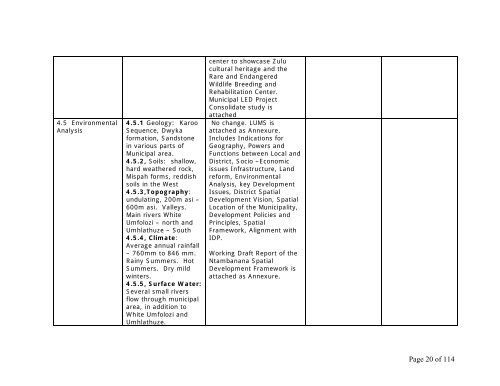
4.5 Environmental Analysis 4.5.1 Geology: Karoo Sequence, Dwyka formation, Sandstone in various parts of Municipal area. 4.5.2, Soils: shallow, hard weathered rock, Mispah forms, reddish soils in the West 4.5.3,Topography: undulating, 200m asi – 600m asi. Valleys. Main rivers White Umfolozi – north and Umhlathuze – South 4.5.4, Climate: Average annual rainfall – 760mm to 846 mm. Rainy Summers. Hot Summers. Dry mild winters. 4.5.5, Surface Water: Several small rivers flow through municipal area, in addition to White Umfolozi and Umhlathuze. center to showcase Zulu cultural heritage and the Rare and Endangered Wildlife Breeding and Rehabilitation Center. Municipal LED Project Consolidate study is attached No change. LUMS is attached as Annexure. Includes Indications for Geography, Powers and Functions between Local and District, Socio –Economic issues Infrastructure, Land reform, Environmental Analysis, key Development Issues, District Spatial Development Vision, Spatial Location of the Municipality, Development Policies and Principles, Spatial Framework, Alignment with IDP. Working Draft Report of the Ntambanana Spatial Development Framework is attached as Annexure. Page 20 of 114
Umhlathuze water is bulk water supplier. 4.5.6, Ground Water: Most fit for short-term use by animals and humans. Classes 1, 2, 3 exist. Obuka rural area relies on boreholes. Water to the north not consumable. 4.5.7, Aesthetics: Low levels of pollution and emissions. No industrial development. No major roads. Good air quality. 4.5.8, Waste management: No formal programme. Informal dumping. 4.5.9, Natural Vegetation: Moist Zululand Thornveld, moist hinterland African Ngongoni veld, Dry Zululand Thornveld. Bioresources Groups 3, 19, 20 prevalent. 4.5.10, Protected Species, See annexure. Source of Ref is KZN Wildlife 2000 4.5.11, Land Page 21 of 114
- Page 1 and 2: NTAMBANANA LOCAL MUNICIPALITY (KZ 2
- Page 3 and 4: E.14 Annexure E.14.1 Land Use Manag
- Page 5 and 6: 4.4 Economic Analysis 4.5 Environme
- Page 7 and 8: 26 October 2005: Consultant briefs
- Page 9 and 10: D. PROCESS REPORT outlining the pro
- Page 11 and 12: 1) Community Consultation 2) Steeri
- Page 13 and 14: CHAPTER 6 Section 38 (a) (iii) - PM
- Page 15 and 16: 10. Closing Prayer at 12h30 -Encour
- Page 17 and 18: E.DRAFT IDP REVIEW 2006/2007 Review
- Page 19: agriculture. 4.4.2 Employed: 7395.
- Page 23 and 24: 4.6 Spatial Analysis Edwaleni; Prim
- Page 25 and 26: 4.8 Alignment of National, Provinci
- Page 27 and 28: 4.9 Financial Analysis prioritize N
- Page 29 and 30: 5.3 DLGTA grants to DC and KZ in ne
- Page 31 and 32: 6.6 Poverty Alleviation and Gender
- Page 33 and 34: REVIEW ITEM 2005 / 06 STATUS 2006/0
- Page 35 and 36: 7.3 HIV/Aids 7.4 Disaster Managemen
- Page 37 and 38: 7.7 Tourism Plan Concentrated on ge
- Page 39 and 40: 7.9 Energy Sector Plan 7.10 Cemeter
- Page 41 and 42: 8.PROJECT REVIEW The following Proj
- Page 43 and 44: TOTAL (LED Projects) 124,144 NTAMBA
- Page 45 and 46: Total R 335 921,247 100 PROJECT-3 Y
- Page 47 and 48: acquisition and development Ward 1:
- Page 49 and 50: Projects -3 years REVENUE & EXPENDI
- Page 51 and 52: Ward 4 Enhlubeni ESKOM R100, 000 Wa
- Page 53 and 54: Ward 5 Nsimbakazi ESKOM R297, 000 R
- Page 55 and 56: D. PROJECT- 3YEARS REVENUE AND EXPE
- Page 57 and 58: PROJECTS -3 YEARS REVENUE AND EXPEN
- Page 59 and 60: PROJECT -3 YEARS REVENUE AND EXPEND
- Page 61 and 62: 2005/2008 and three year Total PROJ
- Page 63 and 64: Ward8: community fares in each sub-
- Page 65 and 66: Rural housing 1000 even) Ward 6 Bhi
- Page 67 and 68: The following Projects were priorit
- Page 69 and 70: Ward 3 Ward 7 (a) Bhadaza Market St
4.5 Environmental<br />
Analysis<br />
4.5.1 Geology: Karoo<br />
Sequence, Dwyka<br />
formation, Sandstone<br />
in various parts of<br />
Municipal area.<br />
4.5.2, Soils: shallow,<br />
hard weathered rock,<br />
Mispah forms, reddish<br />
soils in the West<br />
4.5.3,Topography:<br />
undulating, 200m asi –<br />
600m asi. Valleys.<br />
Main rivers White<br />
Umfolozi – north and<br />
Umhlathuze – South<br />
4.5.4, Climate:<br />
Average annual rainfall<br />
– 760mm to 846 mm.<br />
Rainy Summers. Hot<br />
Summers. Dry mild<br />
winters.<br />
4.5.5, Surface Water:<br />
Several small rivers<br />
flow through municipal<br />
area, in addition to<br />
White Umfolozi and<br />
Umhlathuze.<br />
center to showcase Zulu<br />
cultural heritage and the<br />
Rare and Endangered<br />
Wildlife Breeding and<br />
Rehabilitation Center.<br />
Municipal LED Project<br />
Consolidate study is<br />
attached<br />
No change. LUMS is<br />
attached as Annexure.<br />
Includes Indications for<br />
Geography, Powers and<br />
Functions between Local and<br />
District, Socio –Economic<br />
issues Infrastructure, Land<br />
reform, Environmental<br />
Analysis, key <strong>Development</strong><br />
Issues, District Spatial<br />
<strong>Development</strong> Vision, Spatial<br />
Location of the Municipality,<br />
<strong>Development</strong> Policies and<br />
Principles, Spatial<br />
Framework, Alignment with<br />
IDP.<br />
Working Draft Report of the<br />
Ntambanana Spatial<br />
<strong>Development</strong> Framework is<br />
attached as Annexure.<br />
Page 20 of 114


