Planning Applications - Runnymede Borough Council
Planning Applications - Runnymede Borough Council
Planning Applications - Runnymede Borough Council
Create successful ePaper yourself
Turn your PDF publications into a flip-book with our unique Google optimized e-Paper software.
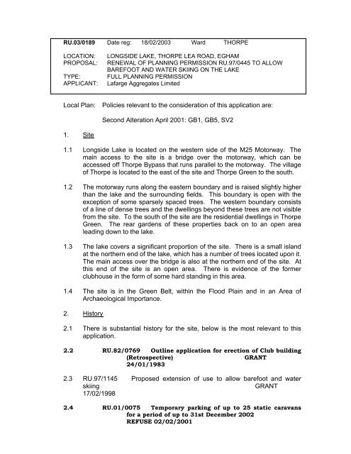
RU.03/0189 Date reg: 18/02/2003 Ward THORPE<br />
LOCATION:<br />
PROPOSAL:<br />
TYPE:<br />
APPLICANT:<br />
LONGSIDE LAKE, THORPE LEA ROAD, EGHAM<br />
RENEWAL OF PLANNING PERMISSION RU.97/0445 TO ALLOW<br />
BAREFOOT AND WATER SKIING ON THE LAKE<br />
FULL PLANNING PERMISSION<br />
Lafarge Aggregates Limited<br />
Local Plan:<br />
Policies relevant to the consideration of this application are:<br />
Second Alteration April 2001: GB1, GB5, SV2<br />
1. Site<br />
1.1 Longside Lake is located on the western side of the M25 Motorway. The<br />
main access to the site is a bridge over the motorway, which can be<br />
accessed off Thorpe Bypass that runs parallel to the motorway. The village<br />
of Thorpe is located to the east of the site and Thorpe Green to the south.<br />
1.2 The motorway runs along the eastern boundary and is raised slightly higher<br />
than the lake and the surrounding fields. This boundary is open with the<br />
exception of some sparsely spaced trees. The western boundary consists<br />
of a line of dense trees and the dwellings beyond these trees are not visible<br />
from the site. To the south of the site are the residential dwellings in Thorpe<br />
Green. The rear gardens of these properties back on to an open area<br />
leading down to the lake.<br />
1.3 The lake covers a significant proportion of the site. There is a small island<br />
at the northern end of the lake, which has a number of trees located upon it.<br />
The main access over the bridge is also at the northern end of the site. At<br />
this end of the site is an open area. There is evidence of the former<br />
clubhouse in the form of some hard standing in this area.<br />
1.4 The site is in the Green Belt, within the Flood Plain and in an Area of<br />
Archaeological Importance.<br />
2. History<br />
2.1 There is substantial history for the site, below is the most relevant to this<br />
application.<br />
2.2 RU.82/0769 Outline application for erection of Club building<br />
(Retrospective)<br />
GRANT<br />
24/01/1983<br />
2.3 RU.97/1145 Proposed extension of use to allow barefoot and water<br />
skiing<br />
GRANT<br />
17/02/1998<br />
2.4 RU.01/0075 Temporary parking of up to 25 static caravans<br />
for a period of up to 31st December 2002<br />
REFUSE 02/02/2001


