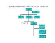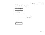
Final Adopted IDP - KZN Development Planning
Final Adopted IDP - KZN Development Planning
Final Adopted IDP - KZN Development Planning

You also want an ePaper? Increase the reach of your titles
YUMPU automatically turns print PDFs into web optimized ePapers that Google loves.
ensure cost-effectiveness. The depiction of the slope analysis within the Municipality<br />
on Plan 4 in Annexure C attached to this <strong>IDP</strong> review document indicates that the slope<br />
variants are evenly distributed throughout the municipal area, with most settlements<br />
located within the more evenly sloped areas.<br />
Precipitation<br />
The Ulundi Municipality has a mixture of two “precipitation sectors” linked to the<br />
varying topography within the municipal area. The two sectors receive average rainfall<br />
of between 722mm to 826 mm per annum, and 827 mm to 912 mm per annum,<br />
respectively. Selected pockets within the Municipality have a higher average rainfall of<br />
between 1012mm and 1251mm per annum. Precipitation within the Municipality is<br />
depicted on Map 4 included in Annexure C attached to this <strong>IDP</strong> review document.<br />
Water Bodies and Catchment Areas<br />
Catchments are the areas of land where rainwater drains downhill into a body of water,<br />
such as a river, lake or dam. The drainage basin includes both the streams and rivers<br />
that convey the water as well as the land surfaces from which water drains into those<br />
channels, and is separated from adjacent basins by a catchment divide. Ecological<br />
aspects need to be taken into account when considering catchment areas. Water that is<br />
accumulated within the catchment areas flows to water bodies such as rivers and dams<br />
which are ultimately utilised to provide potable water for household purposes.<br />
Subsequently it is necessary to consider the possible impacts from specific land uses<br />
(settlements and agriculture) on the quality of water. This will provide an indication, for<br />
example, as to where sanitation services are required to prevent the contamination of<br />
water sources by cholera. In cases where large scale agricultural activity can have a<br />
negative impact on the quality of water it is necessary to limit the use of pesticides.<br />
The spatial development framework of the Municipality is the instrument that needs to<br />
ensure that no land use is proposed in an area where the specific land use can have<br />
detrimental effects on the environment, and the environmental services provided. The<br />
presence of a large number of rivers and high volumes of water also implies that the<br />
safety of communities must be considered by locating them outside possible flood areas.<br />
River Eco-System Status<br />
The river eco-system status has been determined by Ezemvelo <strong>KZN</strong> Wildlife in<br />
conjunction with a programme called the River Health Programme of South Africa.<br />
Based on the assessment of the condition of biological communities in and around rivers<br />
this programme provides an integrated measure of the health of river systems. All of<br />
the rivers in the Ulundi municipal area are classified as vulnerable, which indicates that<br />
85