CalCOFI Reports, Vol. 30, 1989 - California Cooperative Oceanic ...
CalCOFI Reports, Vol. 30, 1989 - California Cooperative Oceanic ...
CalCOFI Reports, Vol. 30, 1989 - California Cooperative Oceanic ...

Create successful ePaper yourself
Turn your PDF publications into a flip-book with our unique Google optimized e-Paper software.
~ 2:48:031<br />
SMITH ET AL.: ZOOPLANKTON PAllERN ANALYSIS<br />
CalCOFl Rep.,<strong>Vol</strong>. <strong>30</strong>,<strong>1989</strong><br />
RELATIVE VELOCITY (cm/sec)<br />
-50 0 50<br />
A. Or<br />
APRIL 6, 1988<br />
2: 15:031<br />
I<br />
W<br />
60 -<br />
t 120 -<br />
n<br />
180 -<br />
Fore-Af t<br />
Port-<br />
Starboard<br />
% Good<br />
NAVIGATIONAL<br />
DEVICE<br />
LAT 32.8058<br />
LON - 1 17.6358<br />
DIR 319.9526<br />
VEL<br />
0.7838 kts.<br />
25 50 75 100 + PERCENT GOOD<br />
0 60 126 190 - AGC<br />
B. 0-1 APRIL 6, 1988<br />
21371035<br />
NAVIGATIONAL<br />
DEVICE<br />
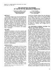
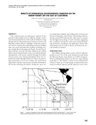
Figure 2. Diagram of the insonification pattern of an acoustic Doppler current<br />
profiler (RDI Inc. manual). Contrary to the diagram, the actual orientation<br />
of beams is 2 fore and aft and 2 left and right.<br />
msec). Since the near-field return data (4 m) were<br />
not collected, the first data on the water column<br />
acoustic backscatter were obtained from a depth of<br />
about 12 m (figure 3). All graphical zero depths actually<br />
refer to 12 m. For each pulse, the amplitude<br />
of the return and the estimated velocity of the layer<br />
were stored in 60 depth “bins,” each representing 4<br />
m. Following nearly a minute of pulses at 1-second<br />
intervals, the ensemble average of each bin was calculated,<br />
and this average was stored as a compact<br />
binary record on a floppy disk. The ensemble averages<br />
of the previous profile were also displayed at<br />
the operator’s console as the next ensemble was<br />
being taken (figure 3). Two of the four vertical profiles<br />
stored each minute are the velocities of the 4-m<br />
layers relative to ship’s motion, as a function of<br />
depth. One of these profiles displays current speed<br />
at right angles to the ship’s motion, and the other in<br />
the direction of the ship’s motion.<br />
There are two accessory profiles. One is the automatic<br />
gain control (AGC), which indicates echo<br />
amplitude with depth, and the second is the “percent<br />
good” value, which indicates the percentage of<br />
pings exceeding the signal-to-noise threshold. Note<br />
60<br />
0 60 126 190 -<br />
I 4l100 I I -<br />
25 50 75<br />
0 60 1<strong>30</strong> 200<br />
LAT 32.8125<br />
LON -1 17.6393<br />
DIR 348.1341<br />
VEL 2.4524 kts.<br />
+ PERCENT GOOD<br />
AGC<br />
I APRIL 6, 1988<br />
NAVIGATIONAL<br />
DEVICE<br />
LAT 32.8163<br />
i LON -117.6417<br />
’ DIR 29 1.6348<br />
180 % Good VEL 1.6274 kts.<br />
--L7<br />
k120L<br />
PERCENT GOOD<br />
* AGC<br />
Figure 3. Specimen profiles. A, The velocity curves extend from 0 to 200 m<br />
and represent the water-layer motion after the effect of ship’s motion in<br />
these planes has been removed. One velocity curve is the port-starboard<br />
velocity; the other is the fore-aft velocity. The curve labelled AGC is the<br />
automatic gain control. The last curve is the “percent good” value expressed<br />
as the percentage of pings in the ensemble that were analyzed for<br />
frequency at each 4-m depth interval. When this value drops below 25%,<br />
the analysis of velocities stops. 6, Profile taken 22 minutes later, showing<br />
the effect of targets on the AGC profile. Velocity curves have been removed<br />
for clarity. C, Profile taken after the targets had passed.<br />
in figure 3A that the AGC is primarily a decreasing<br />
function of depth and that “percent good” remains<br />
above 90% in the first 60 m below the ship, declines<br />
to 75% by 180 m, to 25% by 210 m, and to less than<br />
91