Site/Community Map - Kentucky Cabinet for Economic Development
Site/Community Map - Kentucky Cabinet for Economic Development Site/Community Map - Kentucky Cabinet for Economic Development
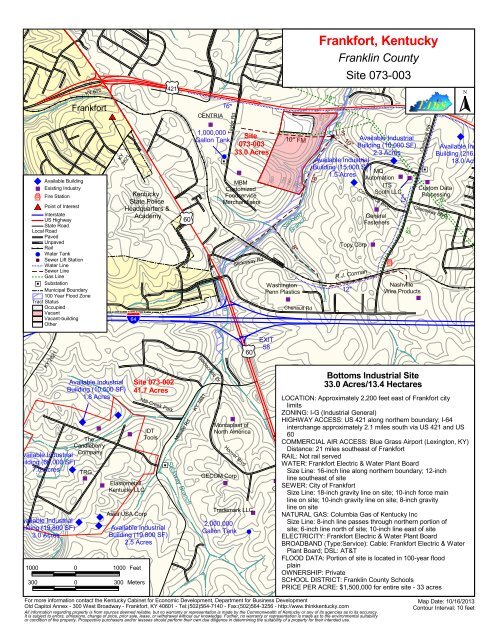
| | | | | | | | | | | | | | | | | | | | | | | | | | | | | | | | | | | | | | | | | | | | | || | | | | | | | | | | % Available Building % Existing Industry þ Fire Station $T Point of Interest Interstate US Highway State Road Local Road Paved Unpaved Rail # Water Tank % Sewer Lift Station Water Line Sewer Line Gas Line %[ Substation Municipal Boundary 100 Year Flood Zone Tract Status Occupied Vacant Vacant-building Other KY 676 Frankfort $T | | KY 2821 | | | | | Kentucky State Police Headquarters & Academy | | | | | | | || | | | 16" CENTRIA % 1,000,000 Gallon Tank Taylor Rd # %[ Site 073-003 33.0 Acres % MBM Customized Foodservice Merchandisers (/ 60 % (/ 60 Slickaway Rd 800 .-, 64 (/ 421 EXIT 790 10" FM 780 760 8" 740 Washington Penn Plastics % 18" Slickway Branch 780 Chenault Rd 760 | Frankfort, Kentucky | | % L.S. Available Industrial Building (10,000 SF) 2.3 Acres Available Industrial Building (15,000 SF) 1.5 Acres MQ Automation % % ITS South LLC || 10" 750 | | Franklin County Site 073-003 8" | | | | | || | | 10" | % | | | | | | | | | | | | | | | || Topy Corp R.J. Corman 12" % General Fasteners | | | | S Scruggs Ln Commerce Blvd % | || | | | % þ 12" 6" Chenault Rd | | | %[ | | Nashville Wire Products % | | | | | | | | | | | | % Custom Data Processing 6" Greenway Blvd 10" || | | | % N Available Indus Building (216,23 18.0 Acres KY 2821 | | | | | Available Industrial Building (10,500 SF) 41.7 Acres 1.8 Acres LOCATION: Approximately 2,200 feet east of Frankfort city limits ZONING: I-G (Industrial General) % HIGHWAY ACCESS: US 421 along northern boundary; I-64 % Montaplast of % IDT North America interchange approximately 2.1 miles south via US 421 and US The Tools 60 Candleberry COMMERCIAL AIR ACCESS: Blue Grass Airport (Lexington, KY) Available Industrial Company Distance: 21 miles southeast of Frankfort RAIL: Not rail served Building (60,000 SF) 7.0 Acres %[ WATER: Frankfort Electric & Water Plant Board TRG Size Line: 16-inch line along northern boundary; 12-inch % GECOM Corp % Elastometall % % line southeast of site Kentucky LLC Greenheck SEWER: City of Frankfort Fan Corp Size Line: 18-inch gravity line on site; 10-inch force main line on site; 10-inch gravity line on site; 8-inch gravity Aska USA Corp Trademark LLC line on site % NATURAL GAS: Columbia Gas of Kentucky Inc Available Industrial Building (19,800 SF) Available Industrial 2,000,000 Size Line: 8-inch line passes through northern portion of 3.0 Acres Building (19,800 SF) Gallon Tank # site; 6-inch line north of site; 10-inch line east of site ELECTRICITY: Frankfort Electric & Water Plant Board 2.5 Acres BROADBAND (Type:Service): Cable: Frankfort Electric & Water Plant Board; DSL: AT&T FLOOD DATA: Portion of site is located in 100-year flood 1000 0 1000 Feet plain OWNERSHIP: Private 300 0 300 Meters SCHOOL DISTRICT: Franklin County Schools PRICE PER ACRE: $1,500,000 for entire site - 33 acres For more information contact the Kentucky Cabinet for Economic Development, Department for Business Development Map Date: 10/16/2013 Old Capitol Annex - 300 West Broadway - Frankfort, KY 40601 - Tel:(502)564-7140 - Fax:(502)564-3256 - http://www.thinkkentucky.com Contour Interval: 10 feet % % % % % % Site 073-002 Mill Creek Park | | | | Millville Rd. Slickway Branch || || | | Democratic Dr KY 1681 | | Hoover Blvd 58 KY 1681 Bottoms Industrial Site 33.0 Acres/13.4 Hectares All information regarding property is from sources deemed reliable, but no warranty or representation is made by the Commonwealth of Kentucky or any of its agencies as to its accuracy. It is subject to errors, omissions, change of price, prior sale, lease, or withdrawal without our knowledge. Further, no warranty or representation is made as to the environmental suitability or condition of the property. Prospective purchasers and/or lessees should perform their own due diligence in determining the suitability of a property for their intended use. | | | | | |
|<br />
|<br />
|<br />
|<br />
|<br />
|<br />
|<br />
|<br />
|<br />
|<br />
|<br />
|<br />
|<br />
|<br />
|<br />
|<br />
|<br />
|<br />
|<br />
|<br />
|<br />
|<br />
|<br />
|<br />
|<br />
|<br />
|<br />
|<br />
|<br />
|<br />
|<br />
|<br />
|<br />
|<br />
|<br />
|<br />
|<br />
|<br />
|<br />
|<br />
|<br />
|<br />
|<br />
|<br />
|<br />
||<br />
|<br />
|<br />
|<br />
|<br />
|<br />
|<br />
|<br />
|<br />
|<br />
|<br />
% Available Building<br />
% Existing Industry<br />
þ Fire Station<br />
$T Point of Interest<br />
Interstate<br />
US Highway<br />
State Road<br />
Local Road<br />
Paved<br />
Unpaved<br />
Rail<br />
# Water Tank<br />
% Sewer Lift Station<br />
Water Line<br />
Sewer Line<br />
Gas Line<br />
%[ Substation<br />
Municipal Boundary<br />
100 Year Flood Zone<br />
Tract Status<br />
Occupied<br />
Vacant<br />
Vacant-building<br />
Other<br />
KY 676<br />
Frank<strong>for</strong>t<br />
$T<br />
| |<br />
KY<br />
2821<br />
|<br />
| |<br />
|<br />
|<br />
<strong>Kentucky</strong><br />
State Police<br />
Headquarters &<br />
Academy<br />
|<br />
|<br />
|<br />
|<br />
|<br />
|<br />
|<br />
||<br />
|<br />
|<br />
|<br />
16"<br />
CENTRIA<br />
%<br />
1,000,000<br />
Gallon Tank<br />
Taylor Rd<br />
#<br />
%[<br />
<strong>Site</strong><br />
073-003<br />
33.0 Acres<br />
%<br />
MBM<br />
Customized<br />
Foodservice<br />
Merchandisers<br />
(/ 60 %<br />
(/ 60<br />
Slickaway Rd<br />
800<br />
.-, 64 (/ 421 EXIT<br />
790<br />
10" FM<br />
780<br />
760<br />
8"<br />
740<br />
Washington<br />
Penn Plastics<br />
%<br />
18"<br />
Slickway<br />
Branch<br />
780<br />
Chenault Rd<br />
760<br />
|<br />
Frank<strong>for</strong>t, <strong>Kentucky</strong><br />
|<br />
|<br />
% L.S.<br />
Available Industrial<br />
Building (10,000 SF)<br />
2.3 Acres<br />
Available Industrial<br />
Building (15,000 SF)<br />
1.5 Acres MQ<br />
Automation % %<br />
ITS<br />
South LLC<br />
||<br />
10"<br />
750<br />
|<br />
|<br />
Franklin County<br />
<strong>Site</strong> 073-003<br />
8"<br />
|<br />
|<br />
|<br />
|<br />
|<br />
||<br />
|<br />
|<br />
10"<br />
|<br />
%<br />
|<br />
|<br />
|<br />
|<br />
|<br />
|<br />
|<br />
|<br />
|<br />
|<br />
|<br />
|<br />
| |<br />
|<br />
||<br />
Topy Corp<br />
R.J. Corman<br />
12"<br />
%<br />
General<br />
Fasteners<br />
|<br />
|<br />
|<br />
|<br />
S<br />
Scruggs Ln<br />
Commerce Blvd<br />
%<br />
|<br />
||<br />
|<br />
|<br />
|<br />
%<br />
þ<br />
12"<br />
6"<br />
Chenault Rd<br />
|<br />
|<br />
|<br />
%[<br />
| |<br />
Nashville<br />
Wire Products<br />
%<br />
| |<br />
|<br />
|<br />
|<br />
| |<br />
|<br />
|<br />
|<br />
| |<br />
%<br />
Custom Data<br />
Processing<br />
6"<br />
Greenway Blvd<br />
10"<br />
|| |<br />
|<br />
|<br />
%<br />
N<br />
Available Indus<br />
Building (216,23<br />
18.0 Acres<br />
KY 2821<br />
|<br />
|<br />
|<br />
|<br />
|<br />
Available Industrial<br />
Building (10,500 SF) 41.7 Acres<br />
1.8 Acres<br />
LOCATION: Approximately 2,200 feet east of Frank<strong>for</strong>t city<br />
limits<br />
ZONING: I-G (Industrial General)<br />
% HIGHWAY ACCESS: US 421 along northern boundary; I-64<br />
%<br />
Montaplast of<br />
% IDT<br />
North America interchange approximately 2.1 miles south via US 421 and US<br />
The<br />
Tools<br />
60<br />
Candleberry<br />
COMMERCIAL AIR ACCESS: Blue Grass Airport (Lexington, KY)<br />
Available Industrial Company<br />
Distance: 21 miles southeast of Frank<strong>for</strong>t<br />
RAIL: Not rail served<br />
Building (60,000 SF)<br />
7.0 Acres<br />
%[<br />
WATER: Frank<strong>for</strong>t Electric & Water Plant Board<br />
TRG<br />
Size Line: 16-inch line along northern boundary; 12-inch<br />
%<br />
GECOM Corp<br />
% Elastometall<br />
% % line southeast of site<br />
<strong>Kentucky</strong> LLC<br />
Greenheck SEWER: City of Frank<strong>for</strong>t<br />
Fan Corp Size Line: 18-inch gravity line on site; 10-inch <strong>for</strong>ce main<br />
line on site; 10-inch gravity line on site; 8-inch gravity<br />
Aska USA Corp<br />
Trademark LLC line on site<br />
% NATURAL GAS: Columbia Gas of <strong>Kentucky</strong> Inc<br />
Available Industrial<br />
Building (19,800 SF) Available Industrial 2,000,000 Size Line: 8-inch line passes through northern portion of<br />
3.0 Acres Building (19,800 SF) Gallon Tank # site; 6-inch line north of site; 10-inch line east of site<br />
ELECTRICITY: Frank<strong>for</strong>t Electric & Water Plant Board<br />
2.5 Acres<br />
BROADBAND (Type:Service): Cable: Frank<strong>for</strong>t Electric & Water<br />
Plant Board; DSL: AT&T<br />
FLOOD DATA: Portion of site is located in 100-year flood<br />
1000 0 1000 Feet<br />
plain<br />
OWNERSHIP: Private<br />
300 0 300 Meters<br />
SCHOOL DISTRICT: Franklin County Schools<br />
PRICE PER ACRE: $1,500,000 <strong>for</strong> entire site - 33 acres<br />
For more in<strong>for</strong>mation contact the <strong>Kentucky</strong> <strong>Cabinet</strong> <strong>for</strong> <strong>Economic</strong> <strong>Development</strong>, Department <strong>for</strong> Business <strong>Development</strong><br />
<strong>Map</strong> Date: 10/16/2013<br />
Old Capitol Annex - 300 West Broadway - Frank<strong>for</strong>t, KY 40601 - Tel:(502)564-7140 - Fax:(502)564-3256 - http://www.thinkkentucky.com<br />
Contour Interval: 10 feet<br />
%<br />
%<br />
%<br />
%<br />
%<br />
%<br />
<strong>Site</strong> 073-002<br />
Mill Creek Park<br />
|<br />
|<br />
|<br />
|<br />
Millville Rd.<br />
Slickway Branch<br />
||<br />
|| |<br />
|<br />
Democratic Dr<br />
KY 1681<br />
|<br />
|<br />
Hoover Blvd<br />
58<br />
KY 1681<br />
Bottoms Industrial <strong>Site</strong><br />
33.0 Acres/13.4 Hectares<br />
All in<strong>for</strong>mation regarding property is from sources deemed reliable, but no warranty or representation is made by the Commonwealth of <strong>Kentucky</strong> or any of its agencies as to its accuracy.<br />
It is subject to errors, omissions, change of price, prior sale, lease, or withdrawal without our knowledge. Further, no warranty or representation is made as to the environmental suitability<br />
or condition of the property. Prospective purchasers and/or lessees should per<strong>for</strong>m their own due diligence in determining the suitability of a property <strong>for</strong> their intended use.<br />
|<br />
| |<br />
| |<br />
|
ec<br />
å University/College e Local Airport<br />
Lock and Dam<br />
ÊÚ<br />
<strong>Kentucky</strong> State Capitol<br />
(/ 127 N<br />
Interstate<br />
US Highway<br />
State Road<br />
Paved<br />
Unpaved<br />
Rail<br />
Franklin County Career and Technical Center<br />
Elsinore<br />
Scenic Byways of <strong>Kentucky</strong><br />
#<br />
Municipal Boundary<br />
County Boundary<br />
(/ (/ 127 421<br />
#<br />
KY Lock<br />
Forks of<br />
å (/ 460 Elkhorn<br />
(/ 421 & Dam 4<br />
<strong>Kentucky</strong> State University<br />
å (/ 60<br />
(/ Building Available Industrial<br />
60<br />
1.5 (15,000 Acres<br />
SF)<br />
<strong>Site</strong> 073-003<br />
33.0 Acres Available Industrial<br />
#<br />
Bon Air Hills<br />
Building (216,235 SF)<br />
(/ 60<br />
18.0 Acres<br />
#<br />
Slickway<br />
(/ 127 ÊÚ Frank<strong>for</strong>t<br />
(/ 421<br />
Available Industrial<br />
Jett #<br />
(/ 60 Building (10,500 SF)<br />
1.8 Acres<br />
EXIT<br />
58<br />
%<br />
Available Industrial<br />
#<br />
Building (10,000 SF)<br />
2.3 Acres<br />
#<br />
.-, 64<br />
EXIT<br />
Available Industrial<br />
53<br />
Building (60,000 SF)<br />
7.0 Acres<br />
Available Industrial Duckers<br />
%<br />
Building (51,200 SF)<br />
<strong>Site</strong> 073-002<br />
4.0 Acres<br />
37.7 Acres<br />
Available Industrial<br />
Building (19,800 SF)<br />
Available Industrial<br />
2.5 Acres<br />
(/ 127 Building (19,800 SF)<br />
3.0 Acres<br />
Wood<strong>for</strong>d<br />
County<br />
Millville<br />
(/ 60<br />
Available Industrial<br />
#<br />
Franklin<br />
Available Industrial<br />
Building (25,885 SF)<br />
Building (19,800 SF)<br />
2.0 Acres County<br />
2.5 Acres<br />
#S Ohio<br />
Indianapolis<br />
#S Cincinnati<br />
Illinois Indiana<br />
Huntington<br />
Louisville<br />
#S<br />
Evansville #S<br />
#<br />
#S ÊÚ #S Lexington West<br />
Frank<strong>for</strong>t Virginia<br />
1 0 1 Miles<br />
Missouri<br />
Virginia<br />
1 0 1 Kilometers<br />
Nashville<br />
Tennessee #S<br />
Knoxville<br />
#S<br />
<strong>Map</strong> Date: 10/16/2013<br />
R.J.<br />
KY 1005<br />
pital City<br />
Airport<br />
e<br />
% Available Building<br />
Local Road<br />
Corman<br />
KY 676<br />
KY 420<br />
KY 420<br />
KY 420<br />
<strong>Kentucky</strong> River<br />
KY 1263<br />
KY 898<br />
KY 2261<br />
KY 1263<br />
KY 1659<br />
KY 1659<br />
KY 1900<br />
KY 2821<br />
KY 1964<br />
KY 676<br />
KY 2821<br />
KY 2822<br />
KY 1681<br />
Frank<strong>for</strong>t, <strong>Kentucky</strong><br />
Franklin County<br />
R.J. Corman<br />
For more in<strong>for</strong>mation contact the <strong>Kentucky</strong> <strong>Cabinet</strong> <strong>for</strong> <strong>Economic</strong> <strong>Development</strong>, Department <strong>for</strong> Business <strong>Development</strong><br />
Old Capitol Annex - 300 West Broadway - Frank<strong>for</strong>t, KY 40601 - Tel:(502)564-7140 - Fax:(502)564-3256 - http://www.thinkkentucky.com<br />
%<br />
% %<br />
% %<br />
%<br />
% %<br />
KY 3360<br />
All in<strong>for</strong>mation regarding property is from sources deemed reliable, but no warranty or representation is made by the Commonwealth of <strong>Kentucky</strong> or any of its agencies as to its accuracy.<br />
It is subject to errors, omissions, change of price, prior sale, lease, or withdrawal without our knowledge. Further, no warranty or representation is made as to the environmental suitability<br />
or condition of the property. Prospective purchasers and/or lessees should per<strong>for</strong>m their own due diligence in determining the suitability of a property <strong>for</strong> their intended use.<br />
South<br />
Elkhorn<br />
Creek<br />
KY 1681<br />
McKees Crossroa


